



Abstract
This paper examines how state territorial development strategies, financial and regulatory practices and architectural and engineering expertise shape ‘volumetric’ urban space. In doing so, it frames the built environment as being an envelope through which state accumulation strategies are materialized through both the technical manipulation of territory and the metrics that accompany it. It focuses on a key site of post-Independence Singaporean urbanism, the Marina Bay area, to examine how dimensional urban development has been combined with governance practices to produce and extract new territory. The paper illustrates this through three processes: the engineering of land platforms that could be developed to expand the logistical productivity of Singaporean territory; the deployment of ‘atmospheric engineering’ such as the use of air-conditioning technologies in creating controlled environments that maximize the value of interiorized territory; and the creation of a calculative regime for governing underground space. It describes how Singaporean state agencies have deployed experts in engineering, surveying and architecture, as well as implementing new legislation and regulation in producing these volumetric affordances. It is argued in conclusion that the calculative manipulation of key sites in the built environments of global cities such as Singapore should be accorded more significance within studies of nation-state territorial strategy, and the geopolitics of cities.
Introduction
This paper aims to reinterpret the production of global cities as urban territories, integrating a dimensional, material approach to the configuration of high-value urban space with political geography approaches to territory as based on extraction (Mezzadra and Neilson, 2017). State territoriality can be understood as being about the arrangement of more than just surface land plots, and the repertoire of state technologies that work to measure the qualities of land in a multidimensional way has grown, sometimes spectacularly (Easterling, 2014; Jackson and Delladora, 2009). As part of his significant work on the emergence of territoriality as a practice, Elden (2013: 49) argues that the volumetric could be fruitfully applied within geopolitical theorization: there is real potential in working out in detail its two aspects: the dimensionality implied by ‘volume’ and the calculability implied by ‘metric’. The political technology of territory comprises a whole number of mechanisms of weighing, calculating, measuring, surveying, managing, controlling and ordering. These calculative techniques – similarly to those employed in biometrics and geo-metrics – impact on the complexities of volume. In terms of the question of security, volume matters because of the concerns of power and circulation.
The paper draws on the example of Singapore as a means of exploring this argument. The aim of this paper is to examine how Singaporean state agencies, particularly the Urban Redevelopment Authority (URA), have drawn on technical expertise and various forms of calculative governance to expand the volume of Singaporean territory. It draws upon recent work within political geography about the volumetric manipulation of territory (for example, Elden, 2013; Steinberg and Peters, 2015). It views Singapore’s sociopolitical emergence as a global city as being intimately linked to how the state has extended and valorized its territory, an argument that has already been carefully delineated by several authors (for example, Bunnell et al., 2006; Shatkin, 2014; Yap, 2013). However, given the intensity of Singaporean land use, with its dense urban fabric of sub-surface development, preponderance of high-rise commercial and residential buildings and interlocking building envelopes, the paper proposes an approach that goes beyond a simple focus on ‘land’ development to provide a volumetric spatial politics of urban redevelopment. In other words, it argues that it is the recognition of the dimensions of urban space as a key part of the regimes of accumulation that have underpinned the city’s growth as a ‘developmental city-state’ (Olds and Yeung, 2004; Shatkin, 2014). Notably, the government has an additional stake in the outcomes of development because of how it uses its sovereign wealth fund, Temasek Holdings, to take significant shareholdings in some of Singapore’s major developers, such as CapitaLand and Keppel (40% and 21% respectively in 2010) (Shatkin, 2014: 121).
The paper begins by expanding discussion of volumetric spatial development in existing scholarly literature, bringing together recent political geographic theorizations of volume and territory, with work that has brought a Foucauldian perspective to the study of city governance. Singapore has emerged as one of the key theoretical sites for applying a governmentality optic, given the contiguous relationship with sovereign nation-state power, including biopolitical approaches (Lee K-W, 2013; Waldby, 2009). The remainder of the paper considers these issues through an examination of how Singapore’s territory has been altered in different ways. The empirical focus is on the redevelopment of Singapore’s Marina Bay, a sizeable area of largely reclaimed land which has acted as the centrepiece of the Singaporean government’s repositioning of the city-state within regional and transnational financial transactional space. The state’s comprehensive interventions in this area, from its large-scale land reclamation to the huge district cooling system that sits beneath its new cluster of skyscraper buildings, to its volumetrically remarkable Sands casino, hotel and retail complex, and the network of metro stations and walkway tunnels that constitute public space in much of the central city, makes this space highly challenging for conventional urban analysis. The paper examines this through three conceptual axes: the role of newly created land platforms in expanding the logistics of Singaporean territory, aimed at enhancing both territorial and extraterritorial (air, maritime) productivity; the importance of ‘controlled environments’ for maximizing the value of interiorized territory; and the creation of a calculative regime for governing underground space.
Towards a volumetric urbanism: the qualities of territory
Political geographers have made some important advances in thinking through how volume might be understood in the process of state- and nation-building. In his account of how scientific practices of geology became embedded with the governance of Canadian territory, Bruce Braun argues for a closer focus on Foucault’s observation that ‘one of the unique aspects of modern forms of political rationality was that the problem of population and its improvement necessarily brought the state directly into contact with its territory – and more precisely, with the qualities of this territory’ (Braun, 2000: 12). He picks out a precise statement of Foucault’s intent to support this: Government is the right disposition of things … I do not think this is a matter of opposing things to men, but rather of showing that what government has to do with is not territory but rather a sort of complex composed of men and things. The things with which in this sense government is to be concerned are in fact men, but men in their relations, their links, their imbrication with those other things which are wealth, resources, means of subsistence, the territory with its specific qualities, climate, irrigation, fertility, etc. (Foucault, 1991: 93, quoted in Braun, 2000: 1).
There has also been a growing political geography literature on the use and consequences of vertical air power on surface territory, and as an extension of territorial control (Adey, 2010; Elden, 2013; Graham and Hewitt, 2013), with some particularly striking studies of how this impacts the Israel–Palestine territorial struggles (Graham, 2016; Weizman, 2002, 2012). The key point, whether studying the above-ground or the subterranean, is that ‘practices of territory – of securing space to achieve particular ends – work through more than area alone’ (Bridge, 2013: 55). Steinberg and Peters (2015), reviewing this political geography literature, make an important distinction between how Weizman and Elden conceive of volume and verticality: For Weizman, the vertical is opened by ‘severing the territory into different, discontinuous layers’ (2002, emphasis added): the subterrain, the surface, the air. For Elden, by contrast, territory is constructed not just by projecting power upwards and downwards, between and across fundamentally horizontal surfaces. Rather, territory—a political technology that combines control of land and terrain with ideas about its capacity for organization through calculative rationality—is achieved through the control of volumes. (Steinberg and Peters, 2015: 251)
However, the scholarly literature on the architecture, design and development of volumetric space has been relatively sparse, perhaps reflecting the difficulty in reconciling an architectural focus on the individual building with the functionality of research in engineering and property. As Graham and Hewitt (2013: 75) have argued, existing urban concepts are insufficiently sensitive to the power of dimensions and so a fully volumetric urbanism is required which addresses the ways in which horizontal and vertical extensions, imaginaries, materialities and lived practices intersect and mutually construct each other within and between subterranean, surficial and suprasurface domains.
While there is a discernible literature which treats urban space as volume (e.g. Harris, 2015), there is also a separate literature that examines the measurement and metrics of land. A key reference point is Mitchell’s (2002) study of colonial Egypt, Rule of Experts, which demonstrates how various expert practices, such as land surveying, brought the modern Egyptian state into being. Generalizing from this, we can note that land development has its own techniques of calculative practice. First, there are those used in engineering and architecture to explain and measure technical performance of these volumes: the algorithms that measure the sway of a skyscraper, for example, which measure how the external force of wind or an earthquake relates to the stiffness of a building (measured in newtons per metre), the displacement of a building, its dynamic mass (in kilograms), velocity and acceleration (measured in metres per second), to calculate how much damping might be applied. The second set of calculations consist of different techniques of financial accounting as it relates to land development. These range from methodologies of land valuation (such as discounted cash flow modelling), cost of finance, marginal cost of adding additional floors and so on. Many of these calculations are governed by risk: they are difficult to calculate with precision in any large project as they may be subject to changing costs of material supply, changing interest rates or credit ratings.
The state has clear motivations in how it becomes involved with both of these calculative areas, particularly in its search to maximize the value of public land. Professional surveyors have always been key agents in the foundation of colonial states: as Mitchell (2002) notes, the ‘clerks in the survey office converted theodolite and chain readings from the field into distances to be drawn on the map’. These people, aggregated, were a ‘calculating apparatus’ with ‘the mechanical powers of a computer’. And so ‘the new world of modern politics is organized to manufacture the effect that this difficult, unstable, temporary distinction between hard and soft, physical and mental, real and representational, is a permanent, fundamental, and ontological divide’ (Mitchell, 2002: 117).
It is Mitchell’s contention that it is through these mechanical, calculative processes ‘that the economy is brought into being’ (p. 117). Similarly, Braun’s aforementioned study (2000) describes some early ways in which Canadian mining – a key element of early nation-building – was intrinsically linked to state-led land valorization. He cites the influence of the mining engineer Eugene Coste in setting out modes by which property rights could be understood below ground, a key element in the development of Canadian territory: In short, in order to optimize use of the nation’s ‘vertical’ territory, property regimes needed to include the internal architecture of the earth. Or, more to the point, the regulation of property had a new objective: to compel individuals to do with the nation’s geological resources what they ought. The first, most important step in that direction, Coste argued, was to separate surface from subsurface rights, since this would encourage prospecting where at present it was discouraged by existing forms of private property. Moreover, with this separation it would be easier to regulate mining through a series of leases and ‘good legislation’ that established the conditions (royalties, annual lease payments, penalties for unworked deposits, annual inspections, etc.) through which efficient mining could be encouraged. (Braun, 2000: 34)
The following sections examine the volumetric underpinnings of territory, with the intent of exploring how Singapore as a city has been partly built upon a heterogeneous set of extractive processes (Mezzadra and Neilson, 2017) for its reclaimed land platforms, its comfortably conditioned air and its subterranean strategic objectives. It is important to stress that Singapore, with its contiguous sovereign territory and ‘city’ master-planning and development strategies, has a certain singularity. However, as is discussed further in the conclusion, it is far from alone in its use of exceptional zoning and development powers to enhance the capacity of specific parcels of their territory to be used for the extraction of value.
Expanded ground, anticipatory geographies: Infrastructural platforms as national territory
Corporate and state power in the natural resource sector is commonly constituted through volumetric practices … the exercise of power involves technologies of calculation, visualization and manipulation around volume. Direct examples include the way proposals for new resource projects – an irrigation reservoir or gas field, for example – are often couched in technical languages associated with volume measurement; mandates to inventory the void-spaces and absences created by extraction (subsidence, flooding, safety hazards); and assessments of commercial value (acre-feet of water, billion cubic meters of gas) that establish whether a ‘bump in a geologists’ mind’ (as one oil company manager put it) becomes a going concern. I suggest, then, that volume is a primary metric of anticipation and potential: calculations of what space contains (cubic meters of gas, ounces of gold), and what contained materials mean that space could become, are essential to the performance of resource landscapes. (Bridge, 2013: 56; emphasis added)
Singapore’s ruling party has been highly effective in politicizing the governance and planning of space, as a means of shaping the national body politic (e.g. Shatkin, 2014). Through the linking of the material expansion of its ground plane through infrastructural platforms based on land reclamation, the government has actively manipulated its ground plane as a mode of anticipation of what the future Singapore might be as a resource landscape. As with natural resources, so do infrastructural platforms act, not just as engineering projects, but as calculated territories central to national growth strategies and narratives.
This has been a fairly common story in many Asian cities, one that has been increasingly charted by urban theorists. For example, Frampton et al.’s (2012) Cities Without Ground: A Hong Kong Guidebook makes a convincing case for understanding that city as being defined by its elevated planes: Ground is a continuous plane and a stable reference point … In cities like New York, great cultural significance is placed in being on the spatial ground … Hong Kong enhances three-dimensional connectivity to such a degree that it eliminates reference to the ground altogether. (p. 6)
Under the leadership of Lee Kuan Yew, Singapore separated from Malaysia in 1965 after a breakdown in political understanding between the two sides. Crucially, this meant that the hinterland upon which Singapore had long relied was no longer readily available, and – given the political control of ethnic majorities in each state (Chinese in Singapore, Malay in Malaysia) – this has always been a matter of some geopolitical tension. The survival of the state was thus based on maximizing its territorial resources, and government planners soon realized that it would need to expand its extraterritorial presence through the creation of a series of land platforms that would support various strategic economic developments (see de Koninck et al., 2008). These were of economic and infrastructural significance: the reclaimed Jurong and Tuas zones, which in total added 5000 hectares in surface area, zoned for much of the state’s heavy industries such as petroleum and petrochemicals; Changi Airport, based on 870 hectares of reclaimed sea and swampland; and Marina Bay, discussed further below. This was combined with external ‘enclave’ interventions in the Indonesian island of Bintan (Bunnell et al., 2006): The basic vision was for Singapore more effectively to manage the cross-border hinterlandization of its economy, providing capital and strategic direction while securing access to both Malaysian and Indonesian labour, land and water. Singapore, in short, was to supply the capital, and Johor and Riau were to provide the land and labour. (Sparke et al., 2004: 486)
With Changi, the land platform has over the years been used as a means of promoting business and passenger mobilities. However, as Lin (2014) shows, this has been tightly tethered to the need to successfully negotiate airspace capacity through advanced air traffic control technology, for example. There have been ‘three instances in which the city-state’s aeromobilities have been curtailed in the course of its post-Independence flying career—its (obstructed) procurement of air traffic rights; its inability to independently set air navigation rules; and its subjection to recent climate change debates and regulations’ (p. 94). These regulatory frameworks are, through the use of externally defined rules and standards, significant factors in territorial governance.
Regardless of its struggles to enter such globalized spaces, Changi, Jurong Tuas and Marina Bay are both emblematic of, and singularly important to, Singapore’s remarkable programme of territorial reconfiguration. While its surface footprint increased by 22% since 1965, from 58,000 to 71,000 hectares in 2015, largely through processes of land reclamation (Economist, 2015), it is these concentrated sites of value generation that have been key to the valorization of the wider territory. The development and protection of surface territory, of a ground plane, has always been a central element of nation-state-building strategy. However, the Singaporean state – through its powerful URA – has also engaged in territorial development of a different order, through the active production and integration of high-rise and subterranean planes of economic activity. Powerful ministries, such as the Ministry of Trade and Industry and its subsidiary Economic Development Board, and the Ministry of Finance’s (2010, 2014) Economic Strategies Committee, have placed territorial development projects at the heart of national growth strategies. The URA has thus been empowered to take the lead in shaping numerous megaproject developments marked by the significance of their leasable volume, on the one hand, and infrastructural efficiency, on the other. The URA, an executive land-use body, has jurisdiction over almost every aspect of land development in the city-state, and has had a huge impact on how Singapore has developed. The URA has grown in status due to the unchallenged political control of the government by the PAP, the People’s Action Party, which has formed the government since Independence, and which identified the control of Singapore’s built environment as one of the cornerstones of its political strategy (Shatkin, 2014).
The expansion of Singaporean territory through land reclamation had already been underway prior to Independence, indeed dating back to colonial interventions. The area at the mouth of the Singapore River, which had always been the main colonial port of the island, had been dredged and flattened for port facilities from the 1820s onwards, with further work in the 1920s creating the Telok Ayer area, which subsequently became the locus of the first financial district skyscraper cluster dating from the 1980s. After the transition to Malaysian Independence, and Singapore’s subsequent separation, the process of land reclamation restarted. Under the East Coast Reclamation Scheme, an array of new land platforms was created which were subsequently built and developed in a series of phases. The statutory establishment of the URA in 1974, under the Ministry of National Development, was a key stage in territorial development: ‘as part of Stages VI and VII of the East Coast Reclamation Scheme, three parcels of land – Marina Centre, Marina South and Marina East – were reclaimed to form a man-made bay’ (Yap 2013: 349; see also Chua, 1989). This was carefully measured and structured. As Yap describes, ‘Upon studying the successful waterfronts of Baltimore’s inner harbor, Sydney’s Darling Harbour and San Francisco’s Pier 39, state planners determined that the bay was too large and thus carried out further reclamation to reduce it from 1050 m by 780 m to 900 m by 400 m’ (Yap, 2013: 349; see also Chua, 1989).
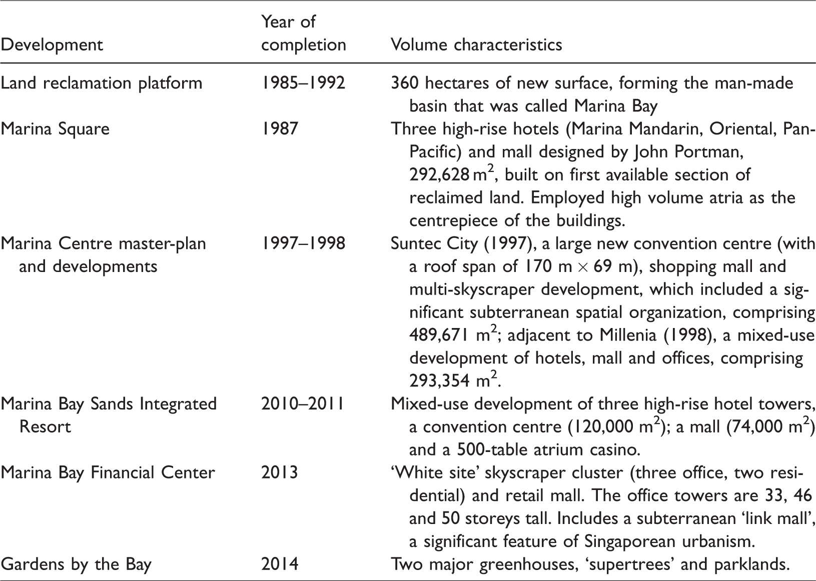
These practices of comparison and territorial calculation were thus important steps in the formation of Marina Bay (for a summary, see Table 1). The establishment of the Marina Bay Development Agency (MBDA) marked the beginnings of the commercial development of the area, which was to be undertaken through phases. This entailed a specific and conscious set of calculations as to how sites were defined and marketed. As Yap describes:
Key developments in Marina Bay.
The Government Land Sales (GLS) programme and the Land Acquisition Act enabled URA (and hence, the state) to effectively maintain control over these parcels of land even as they were sold to private developers at a profit (see Lee, 2010). By zoning Marina Bay into white sites or sites with unspecified uses as a grid pattern, URA was able to amalgamate or subdivide plots of land to accommodate various developments proposed. (Yap, 2013: 394)
The first phase of the development of Marina Bay was clearly geared towards the promotion of business tourism and the convention economy. Once fully built out, the area formed a cluster of five high-rise hotels (the Pan-Pacific, Marina Mandarin, Mandarin Oriental, Conrad and Ritz Carlton) and a huge convention centre, Suntec City, surrounded by five high-rise office towers with its own shopping mall. The hotels were part of a master-plan that included a surface pedestrian network, a series of underground connecting passages, and a series of modernist plazas.
In the 2000s, the government’s focus went beyond business tourism to include the leisure tourist and entertainment economy. This included an array of major projects – the Marina Bay Sands ‘integrated resort’, the huge-scale Gardens by the Bay parks and glasshouses, and an observation wheel (Yap, 2013). Adjacent to Sands, the government zoned for a cluster of ‘white site’ skyscraper commercial buildings. This was developed as the Marina Bay Financial Center, setting between Sands and the existing financial district. This was evidence of how the vertical accumulation of space required subterranean formation of ground several decades prior. As Prime Minister Lee revealed at the opening of the Center: We studied many hubs overseas – Canary Wharf of course; Hong Kong’s International Finance Centre; Shanghai’s Pudong, then just taking off. We identified the features we needed – large floor plates, at least 3,000 m2; double power feed; mixed use development, to work, live and play. None of these were then available in our prime office space. Eventually, after much discussion and debate as to how best it should be done, whether it should be done, we decided in 2003 to carve out a large land parcel on Marina South for a business and financial hub, and to put it on the Reserve List. (Lee HL, 2013)
In a similar vein, the construction of Marina Bay Sands, the hotel and casino ‘integrated resort’ complex that acts as a centrepiece of the new waterfront, was itself an important shift in how the state managed its land assets, involving selling land on the open market to casino developers. For Lee (2015), the state was faced with negotiating the morally complex question of the casino, balancing the return to the treasury through gambling revenues, calibrated against the arrangement of space that would maximize this return while minimizing the cultural impact of the casino within the development. This was followed through in the way in which value was, literally, engineered within the complex. Lee points out that ‘the casino occupies 3% of the floor area and 4% of the construction budget, but represents 81% of the total revenue and 40% of the jobs generated by the complex’ (p. 8). The casino design itself, embedded deep within the four-storey basement of the complex, had as its centrepiece a huge crystal chandelier, the weight of which posed significant design challenges: Composed of an intricate weave of high strength cables suspended from an undulating perimeter steel compression ring, the feature chandelier high above the main gaming room of the casino supports a network of 16 500 LED lights and over 130 000 precision-cut Swarovski crystals. With a footprint of 520 m2 and measuring approximately 24.4 m across and over 6 m deep, this signature piece is one of the largest installations of its kind anywhere in the world, nestled snugly between the finished ceiling above and a series of decorative ceiling ribs below. (Lai and McCafferty, 2012: 42) Given the compressed construction schedule of the project, the casino roof was erected and the ceiling ribs were being fabricated before the final configuration of the chandelier had been established by the architect. Arup was thus tasked with form-finding the fabrication geometry of the chandelier cable net and of analysing the complex buckling behaviour of the chandelier’s compression ring to within extremely tight tolerances. (Lai and McCafferty, 2012: 42)
The four decades of development of Marina Bay, from its first appearance on anticipatory government strategic plans to the opening of the high-rise or high-mass commercial developments of subsequent decades, reveal the extent to which the overall envelope of built space are conceived as central to overall national strategic planning. To maximize returns, however, required a further level of intervention in the built form, focused on creating and maintaining the ideal environment for indoor space use.
Atmospheric engineering: Indoor accumulation and the provision of thermal comfort
Air-conditioning was a most important invention for us; perhaps one of the signal inventions of history. It changed the nature of civilisation by making development possible in the tropics. One forgets this, living in North America or Europe or northern Asia. Without air-conditioning, you can work well only in the cool early morning hours, or at dusk. The first thing I did upon becoming prime minister was to install air conditioners in buildings where the civil service worked. This was key to public efficiency. (Lee Kuan Yew, 1999; quoted in Chang and Winter, 2015)
Lee Kuan Yew’s emphasis on the centrality of air-conditioning to Singaporean life, and hence nation-building, has gathered a degree of renown through his speeches and interviews with the international media (Chang and Winter, 2015). As a means of boosting national productivity, but also a means of ordering the Singaporean body politic, air-conditioning technology became a means of extracting value from Singaporean labour at the same time as putting it at rest, politically and corporeally. As such it can be added to Mezzadra and Neilson’s (2017) list of technologies that have moved beyond ‘literal extraction’ of natural resources to a similar logic of value extraction in the likes of data mining. In the case of air-conditioning, the humidity and heat which is extracted – and pumped back into the building peripheries as externalities – can be valorized through productivity gains.
The essence of such interior accumulation strategies is the enclosure of space, which has been a core part of megastructural developments from the 1960s, if not earlier. For Marvin and Rutherford, such ‘controlled environments’ have become increasingly prevalent and sophisticated within urban environments. Such environments produce a new socio-technical configuration underpinning food production, ecological conservation and human-leisure occupation through various overlapping logics including simulation-synthetic-artificial; secured-enclosed; precision-monitored capacities, etc. Thus, bringing the outside into specific strategic urban ‘insides’ explains why perhaps the ‘outside’ matters less. If infrastructural stretching can bring or replicate or simulate (engineer) important resources, components and processes into a manageable enclosed space then this inside may be seen as sufficient, and everything else as extraneous. (Marvin and Rutherford, 2018: 1147)
Singapore has been influential in Southeast Asia in its widespread adoption of norms of thermal comfort (Sahakian, 2014). As Hitchings and Lee (2008: 257) observe, by the mid-2000s air-conditioning in Singapore had largely reached the point where it was an expectation. In the public sphere, with regard to the office and the school, air conditioning was seen as essential not only for enhancing productivity but also as a courtesy towards employees and students who themselves worked hard to ensure the collective organizational success. the podium-tower typology formed a striking contrast to the low-rise, dilapidated and overcrowded shophouse typology that it displaced. Thus, the hermetically sealed air-conditioned office tower in Singapore was not simply a universal form. It was also a typology driven by and deeply entangled with the post-Independence Singapore state’s developmental agenda of modernising, sanitizing and rationalising the built environment. This new environment was in turn conceived by the state as a part of the larger project to socially engineer and discipline the population to turn them into modern subjects and productive workers. (Chang and Winter, 2015: 107) In the 1960s–70s we begin to clearly see the interdependence between building typology, architectural design, constructional systems and air conditioning. The introduction of the podium-tower typology locked the builders into the use of mechanical cooling, just as the proliferation of air-conditioned buildings led many designers to discard the external sun-shading devices and to use glass curtain walls as building envelopes. (Chang and Winter, 2015: 108) In the days when on-street parking was widespread, the most prominent shops faced the main roads, displaying the goods in wide and open windows for all to see. And there was plenty to see for pedestrians walking on five foot ways all along the main shopping roads. To a large extent it can be said that the road influenced the form and pattern of commercial development in the cities. (Ong, 1980) All of this is changing now with the development of large shopping complexes, office buildings and hotels, helped in no small way by the advent of mass transit systems … With the underground MRT [mass rapid transit] stations or car parks, pedestrians circulate within the building … The internal space has now become the new centre of human activity … The Peachtree Centre in Atlanta and the Embarcadero in San Francisco embody this new space concept with excellent results. This inside-out space design has created a new urban environment free from air and noise pollution and is safe from vehicular traffic. (Ong, 1980) In a very direct way, the geometric encoding of Portman’s ‘unconventional designs’ – i.e. the atrium – provided the calculus for financial evaluation. Yet it is important to read this financial calculation against the qualitative, affective dimension which was at the core of the Hyatt Regency Atlanta: through its spectacular spatial effects but also through its sheer size, the atrium captured what had been considered externalities – bars, restaurants, birdlife, nature – within the conditioned interior space of the hotel. (Rice, 2016: 41)
In Singapore, his projects during the first phase of Marina Bay built upon his experience in North American convention-based urban master-planning. Portman’s developments included a central shopping mall, Marina Square, linked to three high-rise hotels – Mandarin Oriental, Marina Mandarin and Pan-Pacific – and celebrated the idea of a completely encapsulated experience. This followed the typical North American business convention model, where corporate visitors are expected to not be seduced by the excitement of the host city except for organized ‘excursions’; in return, the hotel replicates a series of business seminar spaces at close proximity to the bedrooms, with restaurants and bars offering the other entertainment options (McNeill, 2005). These hotels were closely linked to the Suntec City convention centre, which was attached to a retail atrium and a set of five office skyscraper towers.
As a territorial affordance, the construction of the first phase of reclaimed land, consisting of the co-located ensemble of Suntec City mall and office towers, and the Marina Square mall and hotel cluster, were, for Lew and Chang (1999), key elements in Singapore’s establishment as Asia’s leading convention destination during the 1980s and 1990s: ‘The centre’s [Suntec’s] importance to the image of Singapore as a global tourism center was even recognized by its being featured on a postage stamp in 1996.’ Pow (2002) goes further in articulating how Suntec was an early example of Singaporean ‘urban entrepreneurialism’, which established the city in terms of defining a competitive advantage from other regionally proximate cities such as Kuala Lumpur, integrating the city with Hong Kong financial capital.
Through the various phases in the construction of Marina Bay, the provision of ‘scaled’ thermal comfort through district cooling schemes and ‘green’ building techniques has been key in the ability to produce comfortable, hence profitable, hybrids of public and private space. Suntec City, in particular, marked a significant change of scale in the adoption of large-scale integration of air-conditioning into megaprojects which ‘required a $400 million mechanical and electrical system with a central chilled-water plant of 23,500 refrigeration-ton capacity, the largest in Singapore and one of the biggest to be installed anywhere in Asia at that time’ (Chang and Winter, 2015: 115).
By the time of the development of Marina Bay East, state agencies were fully focused on rationalizing the volumetric arrangement of its key sites. An important example was the construction of a common services tunnel (allowing infrastructure maintenance at all times without surface disruption such as road-digging) and a district cooling system. District cooling is a form of large-scale storage cooling that had been disregarded in the 1970s for reasons of land scarcity, but which was revived in the 1990s when Singaporean planners studied its use in Yokohama, which had similarly integrated it into a major reclamation project (Arnold, 2002). However, the cost of investment would require locked-in clients, which meant that its adoption at Marina Bay required developers to contract to the cooling supply as a condition of purchase. The URA argued that this would generate revenue to offset cost: The DC [District Cooling] System supplies chilled water 24 hours daily through a piping network for air-conditioning of buildings. The DC System dispenses with the need for individual buildings to have stand-alone chiller plants and there is GFA [gross floor area] savings if the developments choose to take chilled water supply from the DC system. These space savings can then be converted to more usable space. (Urban Redevelopment Authority, 2014: §2.7.3, 4)
Subterraneanism: Renegotiating ground and underground
Perhaps the most obvious consequence of the geologizing of Canada’s territory was that it enabled such places as Canada’s west coast to be drawn into global circuits of extractive capital. (Braun, 2000: 24)
38. Just as Singapore has reclaimed land in advance to support economic growth in the past, the ESC [Economic Strategies Committee] recommends that the government acts early to catalyse the development of underground space. The government can take the lead by: a. Creating basement spaces in conjunction with new underground infrastructural developments (e.g. rail) to add to its ‘land bank’; b. Developing an underground master-plan to ensure that underground and aboveground spaces are synergized and better integrated with surrounding developments and infrastructure; c. Establishing a national geology office to collate underground information that will benefit both private and public sector efforts in underground development; d. Developing a subterranean land rights and valuation framework to facilitate underground development; and e. Investing in underground development R&D and directly investing in cavern level test-beds. (Ministry of Finance, 2014: 100)
Braun’s (2000) account of the ‘verticalization’ of Canadian territory unpacked various ways in which the Canadian state urged citizens to look at its sub-surface in various ways, understanding its mineralogical and geological properties, regulating and encouraging various types of economic relation and inculcating a new sense of visuality with regard to the underground. Interestingly, scholars have noted that there are struggles for control of the portals or ‘puncture points’ that lead to underground (Bridge, 2013). Several scholars have made the link between the extraction of natural resources and the construction of skyscrapers as both a means of sinking capital and coordinating that extraction (e.g. Brechin, 1999). In this context, we can see the significance of the Singaporean government’s enhanced interest in underground.
In 2014, the Singaporean Ministry of Finance identified the development of underground land as a core component of future Singaporean strategic planning (Amin, 2015) . Through the URA, the government subsequently announced its intention to develop a strategic plan for its underground land uses. For many years, the government had emphasized the importance of strategic underground planning, such as integrating the city’s underground pedestrian network with the MRT, partnering with property developers to co-fund underground pedestrian links (UPLs). In 1996, as part of their master-plan, Ideas for a City of Tomorrow, the URA published their idea of a ‘multi-tier pedestrian concept’, stacked levels of commercial and public space integrated within strategic planning strategy. By the early 2000s, large property developers such as Capitaland and Far East had opened link malls, an array of shop-lined tunnels of different proportions and qualities that sewed together existing shopping malls and further integrated walkways to MRT stations (Chang and Winter, 2015). As a 2016 urban design circular stated: Singapore’s city centre is planned as a pedestrian-friendly city, where pedestrians can move around seamlessly and in all-weather comfort. Central to this vision is the development of a comprehensive pedestrian network both below and above-ground that links developments in areas with high pedestrian traffic together and connects them to nearby Rapid Transit System (RTS) Stations … To further facilitate the development of a comprehensive underground pedestrian network within the city centre, URA introduced a Cash Grant Incentive Scheme in March 2004 to co-fund the construction of selected strategic UPLs within the Orchard Road and the Central Business District (CBD) areas, and revised the Scheme in 2012. (Urban Redevelopment Authority, 2016: 1) 4.17.1 The successful tenderer is to include a pedestrian link at the 2nd storey at the part of the development facing Shenton Lane, which will serve as part of the planned 2nd storey pedestrian network linking the development on the Land Parcel to Asia Square and ORQ, as well as the developments within the existing CBD along McCallum Street as shown on the Control Plans. The 2nd storey pedestrian link is to be maintained at a platform level of RL 110.0m and comprise a 6.0m wide pedestrian walkway and a 4.0m wide travellator corridor. (Urban Redevelopment Authority, 2014: 23)
In 2010, in its Economic Development Strategy, the government announced its intention to undertake a comprehensive review of Singapore’s subterranean land, which would ultimately lead to an underground masterplan. This represented the growing desire of the government to regularize the volumetric dimensions of Singaporean territory, and soon it moved to set up a clearer legislative framework surrounding sub-surface land. To this end, in 2015 Parliament considered and then approved two significant amendments to Singaporean law: the State Lands Act and the Land Acquisition Act. In the former case, the amendments ‘clarify that surface landowners own the underground space up to 30 metres under the Singapore Height Datum, unless otherwise specified in the State title’ (Ministry of Law, 2015). The Datum ‘is a level fixed across the whole of Singapore from which height measurements take reference. It is pegged to Singapore’s historical mean sea level. All private landowners will have 30m or more of underground space for development’ (Ministry of Law, 2015). The amendment to the latter Act made it easier for the state to reserve land for specific purposes.
This standardisation is significant, given the cost calculations required for subterranean development in Marina Bay Sands. For example, a significant challenge in the production of developable territory was its material basis, predominantly soft marine clay. Consulting engineers and designers from the project contractor, Arup, summarized their role as follows: The 15.5ha MBS development is founded on the underlying very stiff-to-hard OA [Old Alluvium] layer using a forest of barrettes and 1m–3m diameter bored piles. The average basement excavation depth was around 20m, and with over 40% of the concrete construction occurring 18m–35m underground, the required timetable was only made possible by Arup’s innovative approach to excavation in the first year. Overall, some 2.8M m3 of fill and marine clay was taken from the site, ie about 800 trucks a day for two years! The development also required Arup to engineer a 35m deep cut-and-cover tunnel for the Downtown Line 1 (DTL1) extension to Singapore Mass Rapid Transit rail next to the Benjamin Sheares Bridge, which links the island’s east and west routes and had to remain operational throughout construction. (Iskandar et al., 2012: 12)
As a calculative regime this aligns with a recent scholarly interest in extractivism, which has become a dominant mode of understanding anthropocentric urbanism (Mezzadra and Neilson, 2017). Here, the role of tunnelling as a means of unlocking value is supported by the strategic planning of underground space, a conventional narrative relating to Singaporean global capital aspirations. But the underground strategy also raises some interesting questions about the nature of Singaporean territorial identity: it is such a young polity when compared with other cities such as Rome, London and even New York, which each have highly articulated pasts and the underground reveals sedimented sociospatial stories. The Singaporean strategy has much to do with the awkward ‘burial practices’ identified by Kearnes and Rickards (2017: 50), where subterranean territory is – contra Braun’s account of abundance – a place of emptiness: ‘Models and visualisations that render the underground visible, even into the distant future, provide the intellectual and financial basis for projections of vast, geologically stable underground repositories waiting to be profitably filled with all manner of human by-products, righting what is sometimes cast as their otherwise “wasteful” “emptiness”.’ The underground, in its various guises, thus becomes a key frontier in Singaporean territorial strategy.
Conclusions: Volumetric urbanism and cities as national potential
This paper has reviewed distinct means through which the Singaporean government has worked in various ways to arrange and organize volume as part of a wider process of expanding the state’s territorial base. The material organization of surface, vertical and subterranean reveal the state’s interest in the ‘qualities’ of territory: the vertical is an artifice to negate gravity through the insertion of solid floors often hundreds of metres into the air, via skyscraper mobility technology, protected by the increasingly sophisticated facades that define skyscraper performance; the surface, still dominated by the street as an organizing principle, is augmented and sometimes entirely substituted by crowds moving from high floors into an underground train without exiting into the city street; the subterranean defined by the need to re-engineer solid matter, and to overcome the absence of natural light. This is in line with Mitchell’s (2002) analysis of the importance of expertise in nation-building, especially in territorial formation. Throughout the production of the various spatial typologies considered here, the state has engaged various volumetric experts, from Portman’s distinctive architectural formats, to the air-conditioning engineering specialists behind the district cooling scheme, to the landscape and botany specialists of the glasshouses at Gardens by the Bay.
This suggests that territorial formation is now a highly differentiated process of ‘regimes of expertise’, where engineers, engineering firms and engineering practices are arguably the foundational agents in the production of territory. As Björkman and Harris (2018: 246) suggest in their introduction to a set of papers that seeks to advance this case, urban theory needs to attend to ‘engineering’s central and integral role in processes of urban statecraft, in the fabrication of modern ideals of the orderly and healthy metropolis, and in creating new forms of globalized space’. These technical interventions have been tightly related to calculative processes of territorial shaping. For example, the Singaporean government’s establishment of a National Geological Office has a long historical genealogy in modern state-building (Braun, 2000; Mitchell, 2002). The legislative changes that restructured subterranean legal regimes can be interpreted as a formal recognition that the more efficient use of existing sub-surface territory was more feasible than long-term land reclamation. Along with its other mode of ‘archipelago’ territoriality, creating land platforms for the urban economy, using various modes of manipulating ‘ground’ – and integrating that into a strategic plan that connected underground, surface and vertical air developments – was more than just a technical element of urban planning, but a fundamental reconfiguration of Singapore’s territorial qualities.
This ‘plastic’ reconfiguration of urban territory is not limited to Asian city-states such as Singapore and Hong Kong. To take London Docklands as one example, this concentrated zone of real-estate investment was central to the Thatcherite regime of accumulation (Merrifield, 1993). Its stacking diagrams of large, unobstructed floor plates, a relative novelty in the UK at the time, were key technologies in realizing that accumulation. However, it was only with the adoption of a fuller volumetric engineering, first through the tunnelling that accompanied the Jubilee Line extension and then with the Crossrail project, that this calculative governance could be regarded a success. In Singapore, the combination of technologies – architectural, engineering, financial accounting – that delivered the likes of the World Financial Center and Marina Bay Sands can be seen as a very different outcome, one in which the government has micromanaged the development in a way that a volumetric approach – service tunnel, MRT, district cooling – were plumbed in far in advance and delivered concurrently.
Finally, it is important to identify the role of the metric in relation to the valuation and volume (Elden, 2013). As in Mitchell’s discussion of colonial Egypt, the establishment of a geological office is a precursor to the creation of ‘surveyed’ land, effectively producing new territory and allowing underground land to be confidently and transparently valued, traded and developed. The key ‘office’, the URA, has always been a key element of the Singaporean state project, and is known for its significant power and prominence as a branch of government far in excess of comparable city-development bodies in other polities (Shatkin, 2014: 116). However, the decision to formally plan – and hence valorize – its sub-surface provided an important shift in how planners understood the articulation of the vertical and surface elements of the Singaporean mainland, and what lay underneath, evidenced in the low-key, but significant, legislative changes to sub-surface land organization. While this is not a new territorial strategy – recall Braun’s (2000) account of how the Canadian government consciously valorized surface and sub-surface in different ways – it indicates the importance of the volumetric arrangement of the global city for the potential of contemporary nation-state-building.
Footnotes
Declaration of conflicting interests
The author(s) declared no potential conflicts of interest with respect to the research, authorship and/or publication of this article.
Funding
The author(s) disclosed receipt of the following financial support for the research, authorship, and/or publication of this article: Australian Research Council Discovery Project DP120102448, Cool Living Heritage in Southeast Asia.