
Abstract
Rock coasts are widespread in the tropics and exhibit particular morphologies that may be specific to their tropical, micro-tidal location. Notches are particularly well developed, often linked to onshore cliffs and fronted by subhorizontal platforms. Through a review of previously published data across the tropics, average cliff face erosion rates are calculated as 2.15 ± 2.62 mm a−1, intertidal erosion rates 3.03 ± 7.50 mm a−1 and subtidal erosion rates 0.96 ± 0.44 mm a−1. Intertidal erosion rates are variable within and across latitudinal ranges: within 10°N and S of the equator average rates are 1.42 ± 1.22 mm a−1; between latitudes of 10°and 20°, 0.88 ± 1.16 mm a−1 and between latitudes of 20°and 30°, 2.04 ± 2.57 mm a−1. A consideration of temporal variations in intertidal erosion rates provides insights into the potential impacts of climate change on the erosion dynamics of rock coasts in the tropics. This paper highlights some of the interactions over time and space between process and measurement that continue to limit our understanding of, and ability to model, the erosion dynamics of tropical rock coasts. It concludes by identifying potentially fruitful areas for future research.
Keywords
I Introduction
Rock coasts are widely distributed around the world (Bird, 2004; Emery and Kuhn, 1982; Sunamura, 1992; Trenhaile, 1987). They are common in the tropics where, it has been suggested, they may exhibit morphological features that are different compared to those of other climatic regimes (Fairbridge, 2004; Finkl, 2004). Recently it was suggested that the development of rock coast landforms in tropical environments has received limited attention (Dasgupta, 2011). This paper addresses that concern by reviewing literature on rock coasts in the tropics in order to assess present understanding of their erosion rates and dynamics. As a consequence, future research directions are identified.
The tropics correspond to the Tropical rainforest (Af ), Tropical monsoon (Am ) and Tropical savannah (Aw ) categories in the Köppen and the updated Köppen-Geiger climate classifications, with the mean temperature of the coldest month being more than 18°C, rainfall in the driest month exceeding 60 mm and a mean annual rainfall of more than 2000 mm (Bird and Hopley, 1969; Peel et al., 2007). Reading et al. (1995) extend the latitudinal limits of the tropics up to approximately 30°N and S of the equator, in line with Tricart (1972). This paper also uses these limits and so includes large areas of Africa, Asia, Central and South America and Oceania where rock coasts are widespread (Bird, 2004; Emery and Kuhn, 1982). The most northerly study included is in Bermuda, in the North Atlantic Ocean located off the east coast of the United States, at approximately 32°N. The most southerly study is Norfolk Island, located in the South Pacific Ocean between the east coast of Australia and New Zealand, at approximately 29°S. Both continental and island coasts are included. Island coasts are an important component of tropical rock coasts, with an estimated approximately 45,000 tropical islands (Arnberger and Arnberger, 2001). About 7000 of these are in the Atlantic Ocean and the remainder in the Indian and Pacific Oceans. Most fall within the geographical limits considered in this paper. For example, of the 38,000 islands surveyed by Arnberger and Arnberger (2001) in the Indian and Pacific Oceans, only approximately 130 lie outside the latitudinal limits considered in this paper. Both island and continental coasts vary in lithology and include coral, Mesozoic sedimentary rocks, limestones, basalts and granites. They also differ according to their longer-term vertical land movements, associated with plate heating, cooling and reheating, and according to their horizontal movements associated with plate divergence, convergence and collision (Spencer et al., 1987). In addition, there are marked regional variations in sea-level change for the most recent post-glacial period (10 ka to present; Spencer and Viles, 2002). In areas of Australasia, the SW Pacific Ocean and eastern Indian Ocean, present sea level was reached, and in some areas exceeded for a time, approximately 6 ka BP (e.g. Chappell, 1983; Pirazzoli and Montaggioni, 1988; Woodroffe et al., 1990). In the Caribbean Sea, however, present sea level was reached only within the last thousand years (Lighty et al., 1982). This will have influenced not only the formation of intertidal notches on cliffed profiles but also the relative importance of vertical versus lateral growth of corals and carbonate sedimentation and lithification processes (Spencer and Viles, 2002). Notch depth, for example, is likely to be influenced not only by the duration of exposure to marine processes but also by the extent to which the shoreline is sheltered by coral reefs that may provide protection from direct wave attack.
It is generally agreed that, because of their relatively high temperatures and annual rainfall amounts, the humid tropics experience more intense and rapid weathering than other climate regimes (e.g. Reading et al., 1995; Thomas, 1994). Also, the high annual rainfall levels mean that the rivers of the humid tropics deliver approximately 51% of the world’s total river discharge to the oceans (Meybeck, 1993). Because of smaller seasonal variations in precipitation, these freshwater inputs are generally more uniform throughout the year than for mid- to high-latitude rivers (Nittrouer et al., 1995). Although tropical coasts are generally characterized by micro-tidal, low wave energy regimes (Davies, 1964), some can be classified as exposed, e.g. northeast South America, eastern Madagascar and those parts of central east Africa not sheltered by Madagascar, and, seasonally, west- and east-facing coasts of India and southeast Asia (Trudgill, 1985). Trade winds, monsoons and tropical cyclones play an important role in influencing the wave energy to which tropical rock coasts are exposed (Davies, 1980). There is a particular interest in the potential impacts of tropical storms and hurricanes on coral reefs (e.g. Gardner et al., 2005; Graham et al., 2011; Harmelin-Vivien, 1994; Lugo-Fernández and Gravois, 2010; Riegel, 2007). It is recognized that physical disturbances, such as changes in sea surface temperatures or cyclone frequencies associated with El Niño-Southern Oscillation (ENSO) events, influence tropical rock coastal ecosystem structures and there is an interest in linking these changes to rock coast geomorphology (Spencer and Viles, 2002).
The key geomorphological characteristics of rock coasts of the tropics include cliffs, intertidal notches and quasi- or subhorizontal platforms that often terminate with a steep low tide cliff or ramp (Sunamura, 1992; Trenhaile, 1980, 2002, 2010). The intertidal notches and platforms of tropical rock coasts are commonly used as evidence of former sea levels (e.g. Bhatt and Bhonde, 2006; Pirazzoli, 1996; Smithers, 2011; Tija, 1996; Woodroffe and Horton, 2005). In such cases they are generally considered to be associated with wave erosion (e.g. Blanchon and Jones, 1995) although the role of weathering is sometimes given more importance (e.g. Trenhaile, 2002, 2004, 2008). Rock type is also thought to be important in this context, with features associated with limestone coasts said to provide more reliable indicators than those associated with granite because of the lack of published data on rates of notch formation in granite (Pedoja et al., 2008). Tropical rock coasts are also becoming increasingly popular tourist destinations. They provide not just attractive backdrops but also vantage viewpoints and they are becoming increasingly popular sites for the location of resorts (Wong, 1990, 1998, 2000, 2003). In some cases the cliff erosion hazard is considered to be moderate to high. For example, on the limestone coast of Antigua it is recommended that new buildings be set back 15 m from the cliff edge to protect against erosion for a period of 30 years (Day, 2007).
II Morphology
Rock coasts in the tropics typically have an intertidal notch that may have a cliff to the landward side and a gently sloping platform to the seaward side. There has been some discussion as to the occurrence of true marine cliffs, formed by active marine erosion at the cliff toe, in the tropics. It is suggested that they are inherited, rather than active, as evidenced by relatively low angled, well vegetated slopes (e.g. Bird and Hopley, 1969; Tricart, 1959) and that they owe their shape more to subaerial than to marine processes (e.g. Bird, 1985; Pomel, 1979; Swan, 1971). Guilcher (1985), on the basis of evidence from the coast of northeast Brazil, argued that this view needed to be reassessed. Working in the same region, Santos et al. (2011) and Vital et al. (2004) support Guilcher’s (1985) view by providing evidence of active cliff erosion caused by marine attack at the cliff toe. Trenhaile (1987) suggests that cliffed coasts of the wet and dry tropics be distinguished on the basis of morphology: limited cliffing and gentle, vegetated slopes being associated with the humid tropics either due to weak wave activity or deep weathering contributing to mass movements; steep, unvegetated cliffs being associated with the hot, dry tropics. This is with the proviso that ‘the form of coastal cliffs in the tropics actually depends upon a number of factors, including whether the rocks are weathered or not, the degree of shelter of the site, and the rock type’ (Trenhaile, 1987: 171). The importance of subaerial weathering is again emphasized by Fairbridge (2004: 158), who noted that in ‘tropical latitudes hard rocks are typically reduced to etchplains in interior, subaerial situations, but nearer the coast they are usually dissected into inselbergs’. This may be the case for igneous or metamorphic rocks, e.g. Johnson and Baarli (2005), but it is unlikely to be the case on purer, monominerallic, sedimentary rocks such as limestone. Steep coastal cliffs are commonly associated with drowned limestone landscapes, which are widespread throughout Southeast Asia (Bird, 2004; Gillieson, 2005). The steep slopes of tropical limestone towers, Turmkarst, are maintained by the development of basal notches that are not necessarily associated with marine processes (McDonald and Twidale, 2011). In coastal settings, however, the steep sides of such towers are thought to be maintained by marine undercutting through the development of deep cliff foot notches (e.g. Kiernan, 1994; Waltham, 2005).
Pirazzoli (1986: 361) describes a marine notch, or nip, as an indentation or undercutting, a few centimetres to several metres deep, at or close to mean sea level, in coastal rocks. Higgins (1980) differentiates the two, describing notches as being deep, with horizontal or nearly horizontal roofs, and nips as being shallower and characterized by flaring roofs that slope upward and outward at an angle. The upper rock may protrude over the recess below, often alluded to as a ‘visor’, as it can have the appearance of a raised, opened visor on the helmet of a suit of armour (Trudgill, 2011a). Nips, notches and visors are all prominent features on limestone coasts in the warm, microtidal seas of the tropics where marine processes are concentrated in a narrow zone (Sunamura, 1992; Trenhaile, 1987; Trudgill, 2011a). Notches are typically developed in the mid-littoral zone and, although as many as six notch profile types have been recognized (Takenaga, 1968), they generally have a characteristic morphology with recumbent V-shaped or U-shaped profile forms and a point of maximum retreat located near to mean sea level (Figure 1). The point of maximum erosion is considered to be the apex of the U or V, and the vertical distance between the floor of the notch and the outer edge of its roof is thought to increase with tidal range and with exposure to wave action (Christiansen, 1963; Hodgkin, 1970; Kelletat, 1988; Newell, 1961; Pirazzoli, 1986, 1996; Sunamura, 1992; Takenaga, 1968; Trenhaile, 1987). Notches may be fronted by flared slopes and platforms. Although these features are often associated with intertidal erosion on tropical rock coasts, they may also be formed solely by subaerial weathering and revealed by regolith stripping, e.g. in sandstone (see Wray, 1997) and granite (see Kelletat, 1988; Twidale and Bourne, 1976). In some cases it is suggested that, rather than being instrumental in their formation, marine erosion may simply reveal these features (Twidale, 1986; Twidale et al., 2005). Arguably the shore platforms that develop on ancient, stable, cratonic mainland coasts may not be related to mean sea level at all but rather to the depth of subaerial weathering penetration. For example, shore platforms in the Darwin region of Australia that lie within a height range of just below mean sea level to approximately 5 m above mean sea level are considered by Nott (1994) to be linked to depths of subaerial weathering penetration. ‘Etched shore platforms tend to be largely restricted to those sections of coast where the weathering front lies at or above sea level, and they preferentially occur along stretches of coast composed of alternating deeply weathered and relatively unweathered strata’ (Nott, 1994: 513).

Model tidal notch profile, used as evidence of former sea levels showing: top (A), retreat point (B), base (C), depth (D), cliff slope (i), roof and floor height (HR and HF) and roof and floor depth (DR and DF) and elevation (E0) at the time of measurement (T0)
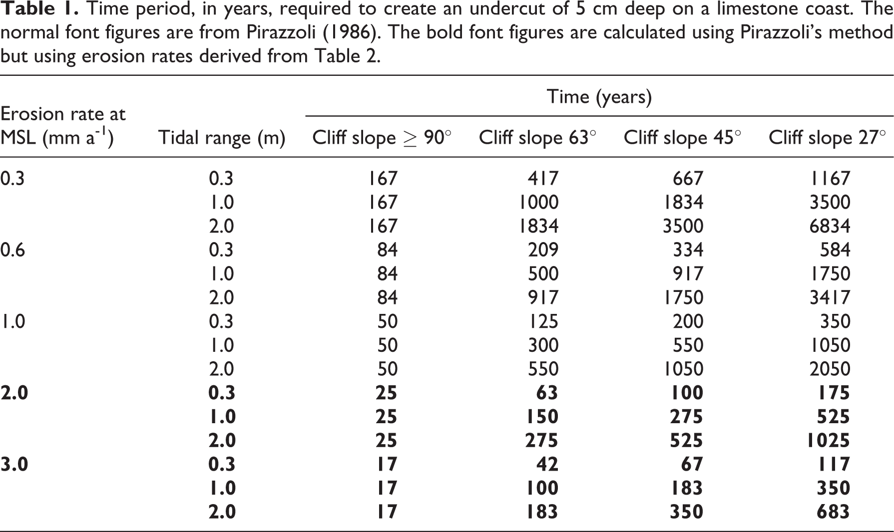
On limestone coasts, however, intertidal notches are thought to be more directly and closely associated with sea level, hence their frequent use as indicators of sea-level change and of tectonic movement (Nunn et al., 2002; Pedoja et al., 2011; Pirazzoli, 1996; Ramírez-Herrera et al., 2004; Tija, 1996). However, Dickinson (2001) notes that within the Pacific Ocean, the French Polynesian literature relating to the southern Pacific Ocean islands links the inland apex of the notch with mean sea level while in the central and southwest Pacific it is linked with the high tide level. He suggests that this is because the much greater tidal range in the southwest Pacific makes it possible to distinguish between mean sea level and high tide level. Pirazzoli (1986) provides a very detailed classification of notches, mainly for the purposes of field identification. Two types of mid-littoral notch are defined: tidal notches, which are the most common and most useful sea-level indicators (Figure 1), associated with sheltered coasts and cut wholly or partly in the intertidal zone; and surf notches, usually cut above high tide level and associated with exposed sites and the presence of a surf bench that protrudes seawards up to as much as 2 m above high tide. Infralittoral notches are also identified and are linked to erosion of the floor of tidal notches such that the overall profile extends up into the infralittoral zone. Supralittoral notches are linked to cavernous salt weathering of granular magmatic rocks and sandstones rather than to direct marine erosion. In addition to these, Pirazzoli (1986, 1996) also identifies structural notches that are more closely linked to differential erosion of weak structural layers than to tidal position, and abrasion notches that can form at any level reached by waves containing granular sediments. Pirazzoli’s classification closely reflects the work of Focke (1978) who, as the result of his research on the limestone coasts of the Netherlands Antilles in the Caribbean Sea, linked notch profile form with degree of exposure to wave action (Figure 2). In open, quiet seawater a simple undercut is generated, the depth of which increases with exposure to increased water turbulence. This is equivalent to Pirazzoli’s (1986, 1996) tidal notch. Greater water turbulence also facilitates a more pronounced zonation of organisms and the build-up of organic accretions, predominated by vermitid gastropods and coralline algae. As these accretions become more pronounced a seaward protruding bench may form, dividing the notch into two separate features and protecting the rock surface behind it. The terms ‘trottoir’ and ‘corniche’ are also used to describe these organic protrusions (Trenhaile, 1987). The notch above the organic accretion is equivalent to Pirazzoli’s (1986, 1996) surf notch. Eventually the upper limit of the spray zone is thought to rise beyond the upper limit of the notch such that the cliff face is degraded by weathering and the notch is replaced by a zone of rugged karren. The notch below the organic accretions shown on the last two stages of Focke’s (1978) model (Figure 2) is equivalent to Pirazzoli’s (1986, 1996) infralittoral notch. Sunamura (1992) noted that Focke’s model is restricted to plunging limestone cliffs because a vertical cliff is assumed as the initial boundary condition and commented that ‘no studies have been made of the influence of the initial landform on morphological features … notch-shaped models applicable to gently sloping limestone coasts are not yet available’ (Sunamura, 1992: 188). Pirazzoli (1986) had, however, presented a series of models to illustrate the influence of cliff slope on notch development on limestone coasts (Figure 3). These models suggest that the angle at which a cliff presents to the sea may exert a very strong influence not only on the shape of the notch but also on the length of time that it takes for notches to develop (Table 1). Pirazzoli’s (1986) models are for tidal notches in sheltered environments and do not, therefore, incorporate the development of organic accretions that may protect the rock from erosion, as outlined in Focke’s (1978) model. Both models are for limestone coasts and the extent to which they are representative of other rock types has yet to be assessed.
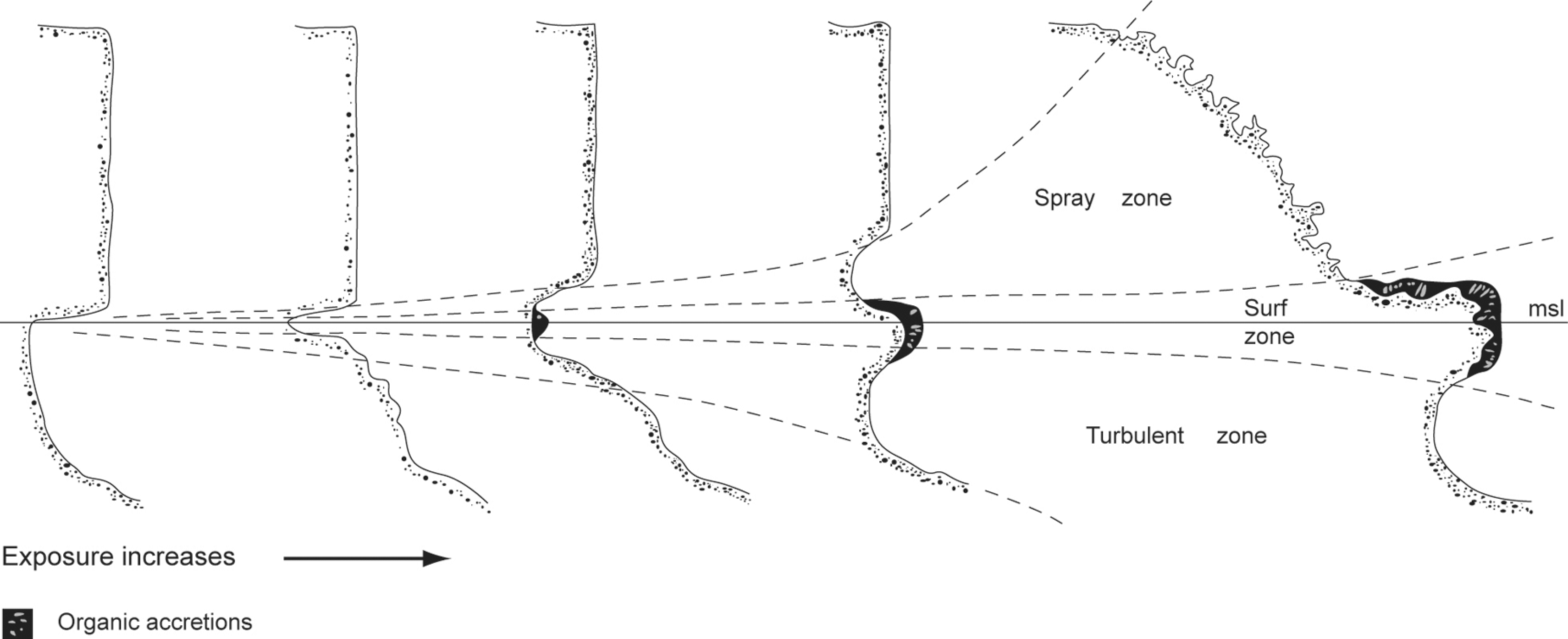
Morphological variation of limestone cliffs as a function of water turbulence.
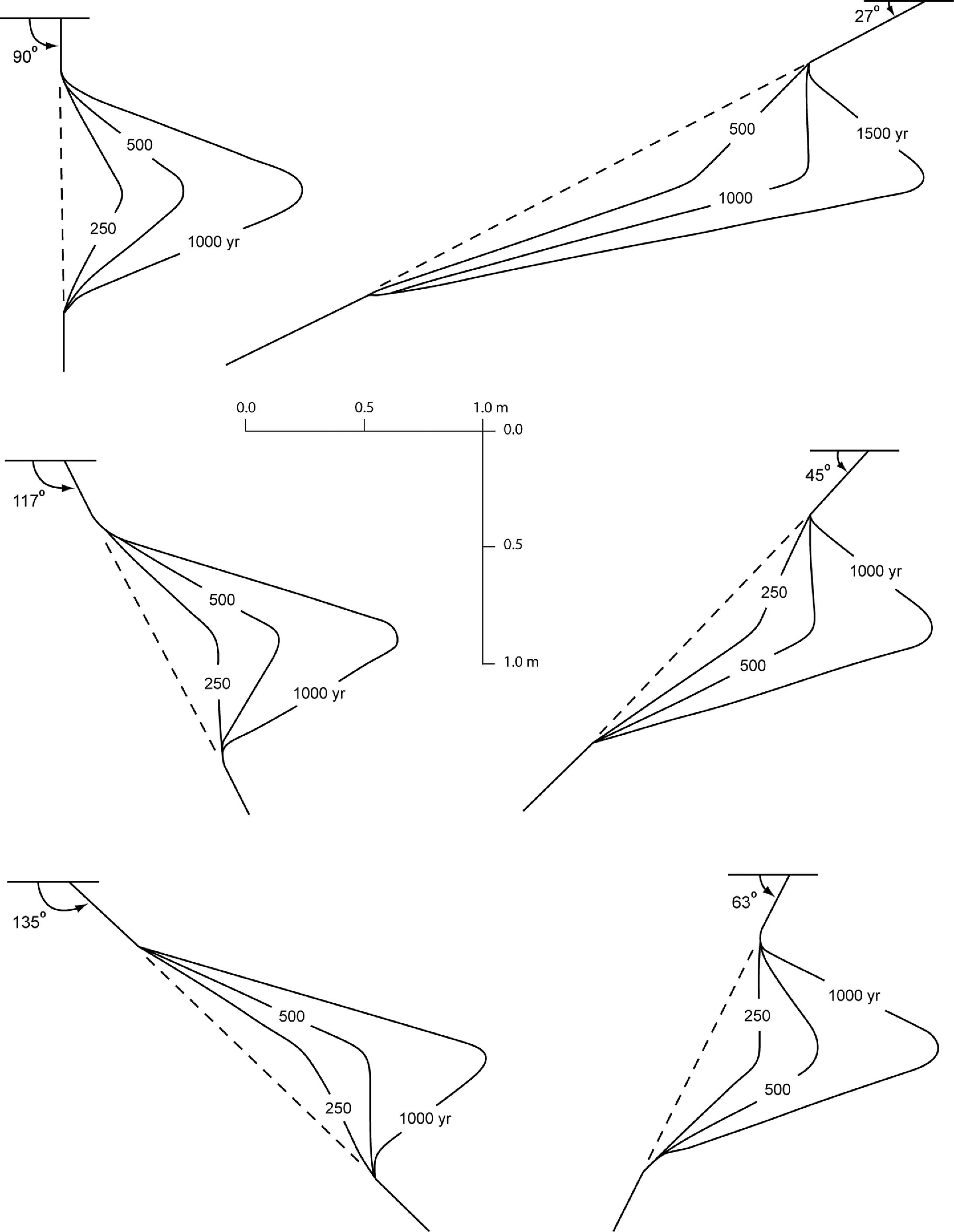
Influence of cliff slope on the development of corrosion notches in a sheltered setting (tidal range is 1.0 m and the rate of erosion at mean sea level is 1.0 mm a−1.
Time period, in years, required to create an undercut of 5 cm deep on a limestone coast. The normal font figures are from Pirazzoli (1986). The bold font figures are calculated using Pirazzoli’s method but using erosion rates derived from Table 2.
Trenhaile’s models sometimes include micro-tidal environments, but they are more specifically concerned with shore platform development than with notch formation (e.g. Trenhaile, 2010; Trenhaile and Byrne, 1986). Trenhaile (2002), for example, notes that, although there is no consensus on the way in which platforms are produced by weathering, the origin of the quasi-horizontal platforms of microtidal tropical environments that terminate abruptly seawards in low-tide cliffs is ascribed primarily to subaerial weathering rather than mechanical wave erosion. Occasionally at the foot of the low tide cliff there is a notch, the origin of which is ascribed to a prior sea level (Dickson, 2006; Sunamura, 1992). Dickson (2006) describes this kind of gross morphology for basalt and calcarenite platforms around Lord Howe Island in the southwest Pacific but is unable to draw conclusions about the role of subaerial versus wave erosion in their formation. He does, however, suggest that platforms develop sequentially from notches. Notch development is held to be responsible for platform initiation such that cliff collapse beyond a threshold notch depth, followed by removal of the cliff talus by wave action, exposes an incipient platform. Although wider platforms were linked to a higher exposure to wave action in some cases, his study was unable to identify any real evidence of an over-arching relationship between exposure and width (Dickson, 2006). There is an interest in linking notch development with cliff retreat in order to assess the periodicity of the rockfalls that may contribute to the development of incipient platforms (Kogure and Matsukura, 2010; Kogure et al., 2006). The macromorphologies of cliffs, notches and platforms have superimposed upon them a series of micromorphologies that are well described and whose zonation is generally linked to the degree of exposure to wave action and to biological processes (see, for example, Fairbridge, 1968; Fischer, 1990; Hopley and MacKay, 1978; Moses, 2003; Spencer, 1988). The process mechanisms and interaction of processes responsible for the development of rock coasts in the tropics remain a subject for discussion.
III Process
Although the traditional debate in the study of rock coasts is concerned with the relative contributions of subaerial and marine processes (Stephenson and Finlayson, 2009; Sunamura, 1992; Trenhaile, 1997), there remains uncertainty about the mechanisms and operation of marine weathering and erosion processes. For example, deep notches are particularly dominant on limestone coasts in the tropics (e.g. Dickinson, 2001; Pirazzoli, 1996; Tija, 1996; Trenhaile, 1987) and it is thought that as much as a third of all tropical coastlines are composed of rocky carbonate substrates (Spencer and Viles, 2002). As a consequence, because of the wide distribution and solubility of carbonate rocks and limestones in particular, there has been much debate about the relative importance of solution and whether it can occur in warm seas. Although sea water is saturated with calcium carbonate, and generally alkaline, a number of mechanisms that would allow solution to take place have been suggested. For example, much of the Ca2+ causing seawater to appear saturated may be complexed or hydrated and thus may not be available for reaction (Revelle and Emery, 1957); undersaturated water may enter the nearshore environment from land drainage or groundwater, or as heavy precipitation falling directly onto the sea (Furlani et al, 2009; Higgins, 1980); the presence of organisms in rock pools may cause increased carbon dioxide levels at night during respiration and hence a fall in pH and an increase in the potential for solution (Emery, 1946; Trudgill, 1976, 1985, 2011b); breaking waves reduce seawater to a foam in which ion ratios are displaced; runoff of a very thin film of water could enhance CO2 exchange with the air and reduce the saturation level such that solution is more intense in thinner films and slower flows; seawater may be undersaturated in respect of the finest grains of a fine-grained micrite and the projecting edges of particles (Schneider, 1976). Trenhaile (1987) suggests that solution may be less effective in tropical waters, while Trudgill (2011b) suggests that it may be more effective in some tropical inshore waters such as in mangrove areas where inshore waters may become acidic if a peat substrate accumulates. Trenhaile’s (1987: 63) conclusion that, although it is possible to quantify the role of solution on limestone coasts, there are ‘insufficient data with which to compare the efficacy of corrosional processes in different [coastal] morphogenic environments’ is still the case. More detailed discussions of the relative importance of solution on rock coasts may be found in Ford and Williams (1989, 2007), Pirazzoli (1986), Revelle and Fairbridge (1957), Sweeting (1972), Trenhaile (1987) and Trudgill (1985, 2011b).
It is a difficult task to isolate the relative contribution of different processes to total erosion rates through field measurements. Spencer (1985a, 1985b) and Trudgill (1972, 1976, 1983) have, however, endeavoured to do this using direct microerosion meter (MEM) measurements combined with weight loss tablets. Rock tablets, representative of the site lithologies, were encased in meshes of different sizes: wide mesh to include all processes, 63 µm mesh to exclude abrasive particles and wire grazing exclusion cages to exclude everything except solution and wetting-drying. These design variations facilitated a quantitative assessment of the relative contributions of bioerosion, abrasion and weathering to the total erosion measured. Their results indicated that bioerosion and abrasion are dominant in intertidal erosion and that solution is of relatively minor importance. Although working on sites with different tidal regimes and wave exposure, both also noted an increase in erosion rates with exposure to wave action. On Aldabra Atoll, Indian Ocean, Trudgill (1972, 1976, 1983) showed that erosion rates increased as much as eightfold with exposure to the dominant South-East Trades. Spencer’s (1985b) measurement sites were in more sheltered locations on the Cayman Islands, West Indies, but he nonetheless noted a sixfold increase in erosion rates from reef-protected to open coasts. Trudgill (1976) suggested that the increase in erosion rates is due to the dominance of physical erosion, including salt weathering, wave quarrying and wetting-drying. Spencer (1985b), however, argued that bioerosion is dominant and subsequently detailed the associated process mechanisms (Spencer, 1988; see also Hutchings, 2011). Spencer (1985b) uses tidal range to explain the differences in observed processes between the two places. Macrotidal regimes, typical of Aldabra (>3 m), he suggests disperse water contact while microtidal regimes, typical of Grand Cayman (0.55 m), provide a more effective sea water pumping action such that physical processes, e.g. wetting-drying and salt weathering, are relatively unimportant (Spencer, 1985b). Both Spencer and Trudgill also found that the presence of sand increases the erosion rate and that the predominance of abrasion over other processes suppresses their operation. Spencer (1985a, 1985b) noted that sand abrasion is the dominant subtidal erosion process whereas biological activity dominates in the intertidal zone. Trudgill (1976) noted that sand abrasion appeared to subdue intertidal bioerosion. Where sand was present bioerosion accounted for 36% of the total erosion and where absent its contribution to the total erosion increased to 64%. These are the main quantitative studies that have attempted to assess the relative contributions of different processes to intertidal erosion on tropical rock coasts and they indicate that solution is of minor importance.
There are situations, however, where field evidence suggests that solution, rather than marine or biological processes, is the dominant process in notch development. For example in Ha Long Bay, Vietnam, where intertidal notches are particularly well developed, Waltham (2005) notes that there is no variation in the notch size in relation to exposure to wave action. Others suggest that the vertical distance between the floor of the notch and the outer edge of its roof should increase with exposure to wave action and marine processes (Christiansen, 1963; Hodgkin, 1970; Newell, 1961; Pirazzoli, 1986, 1996; Sunamura, 1992; Takenaga, 1968). The uniformity of notch dimensions across Ha Long Bay is thought to indicate that solution is the dominant process and that this has been facilitated by the mixing of fresh water, mostly supplied by two large rivers discharging into the bay, with sea water, and also by the chemical corrosion effects of algae (Khang, 1985; Waltham, 2005). Other forms of bioerosion are not discussed. Like Aldabra, Ha Long Bay has a macrotidal range but the limestones are much older. Both Trudgill’s and Spencer’s studies were carried out on geologically recent reef limestones while Ha Long Bay is formed in limestones of Carboniferous to Devonian age (Fenart et al., 1999; Waltham, 2005). This means that the limestones of Ha Long Bay are much harder rocks that are likely to be more resistant to marine erosion processes, including wave impact and abrasion. Also, they are pure, crystalline limestones that are more likely to dissolve directly than via the solutional disintegration that has been noted on the reef limestones of Aldabra (Trudgill, 1976). The proposed solution of notches in Ha Long Bay by mixing of fresh water and sea water or by direct chemical corrosion by algae is not substantiated with geochemical data. Others have drawn on theory and laboratory experiments combined with field observation and geochemical analyses of water samples to substantiate the occurrence of mixing-corrosion in coastal carbonate aquifers (e.g. Romanov and Dreybrodt, 2006; Singurindy et al., 2004; Smart et al., 1988). Similarly, although bioerosive organisms are known to have a widespread occurrence on harder limestones in the tropics (Kázmér and Taboroši, 2012), such as those of Ha Long Bay, their erosive or protective roles in this context have received limited attention.
IV Rates of erosion
Tropical rock coast erosion rates for a range of latitudes within approximately 30°of the equator and measured on a range of rock types, are shown in Table 2. Other authors also provide erosion rate data, e.g. for bioerosion globally (Trenhaile, 1987) and for coral reefs and reef limestones (Spencer, 1988; Trudgill, 1985, 2011b). They present rates that are expressed in a variety of units, including g a−1, cm3 a−1, g m2 a−1 or g d−1, which makes direct comparison difficult. Table 2 reports the results of studies that measure and/or calculate and report erosion in mm a−1 so that direct comparisons can be made. The majority of studies have measured only intertidal erosion encompassing all intertidal processes, while some have focused on the erosive activities of specific organisms such as chitons, gastropods and fish. There are very few measurements of subtidal erosion rates and the author could locate only one study that directly measured cliff face erosion rates in the supratidal zone. The majority of rock types studied are relatively young reef limestones, beachrocks and aeolianites and a range of methods have been used. Some studies have used direct measurement techniques including erosion pins (e.g. Bird et al., 1979; Hodgkin, 1964), measurements against surfaces of known ages (e.g. Kaye, 1959; Stephenson, 1961; Trudgill, 1983; Warthin, 1959) and microerosion meters (MEMs; e.g. Spencer, 1981, 1983, 1985a, 1985b; Trudgill, 1976; Woodroffe et al., 1983). Others have used indirect methods such as weight loss tablets (e.g. Neumann, 1966; Spencer, 1983; Trudgill, 1972) and calculations based on the depths of notches of a known or estimated age (e.g. Hodgkin, 1970; Pirazzoli, 1986; Tija, 1985; Verstappen, 1960). Studies that have measured bioerosion rates have mostly done so using theoretical calculations that incorporate data derived from the chemical analysis of faecal pellets combined with measured grazing densities (e.g. Glynn, 1973; Rasmussen and Frankenberg, 1990; Taylor and Way, 1976) or by measuring borehole depths and dividing them by the ages of organisms (e.g. Vita-Finzi and Cornelius, 1973). Most authors are very clear about their methodology but some are not, e.g. Revelle and Fairbridge (1957). The most reliable rates are likely to be those derived from direct measurement using erosion pins and MEMs, although they are usually specific to a particular very short time period of no more than two to three years’ duration. The difficulties of extrapolating such short-term data, noted by Viles and Trudgill (1984), means that individual studies may not be representative of longer time periods. However, where there are a series of consecutive studies these may give insights into changes in tropical rock coast erosion associated with changing sea levels and climate. Also, much longer time periods, usually of thousands of years, are in theory covered by the erosion rates calculated on the basis of measurements of the depths of notches of a known or estimated age.
Tropical rock coast erosion rates from prior work (MEM denotes microerosion meter).
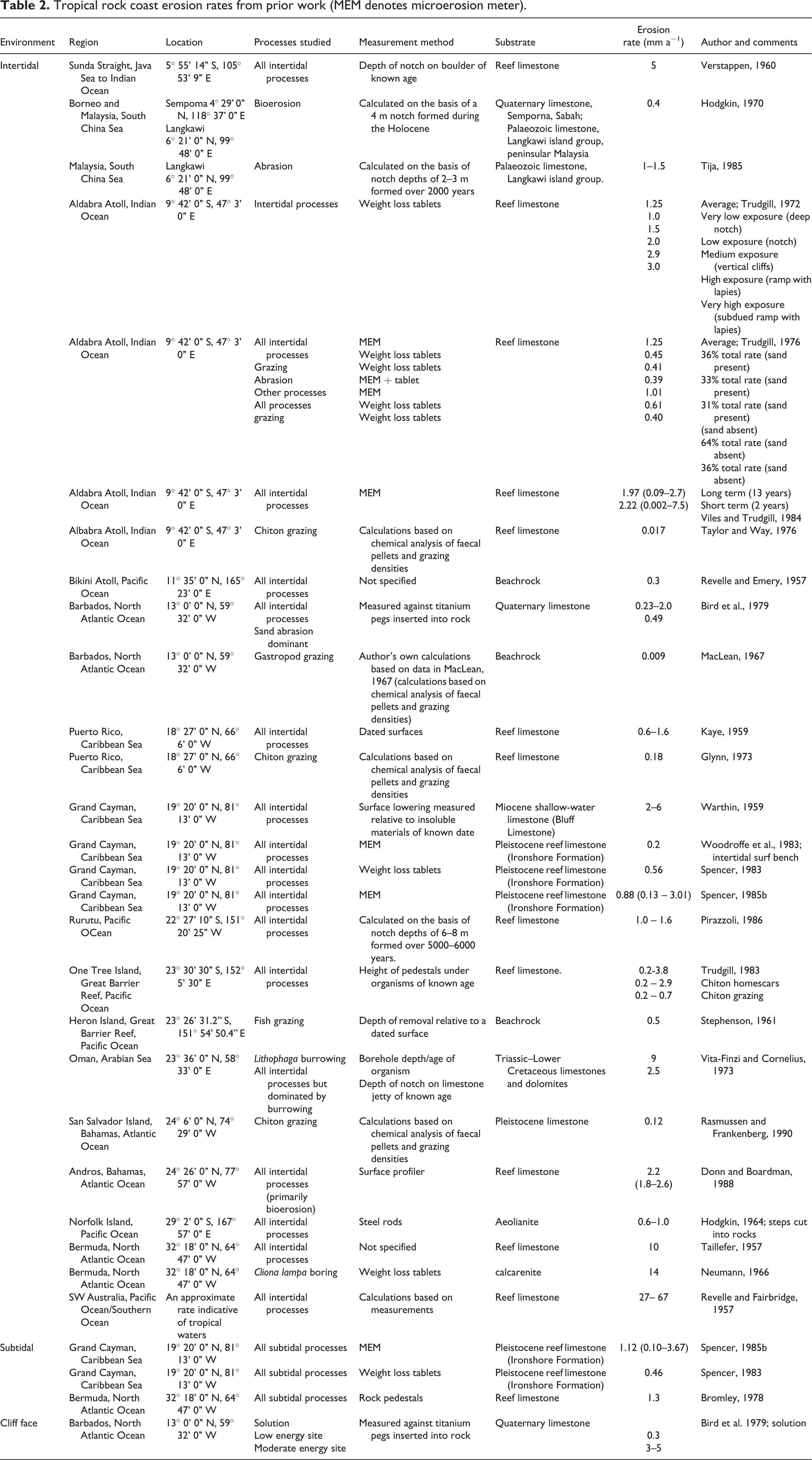
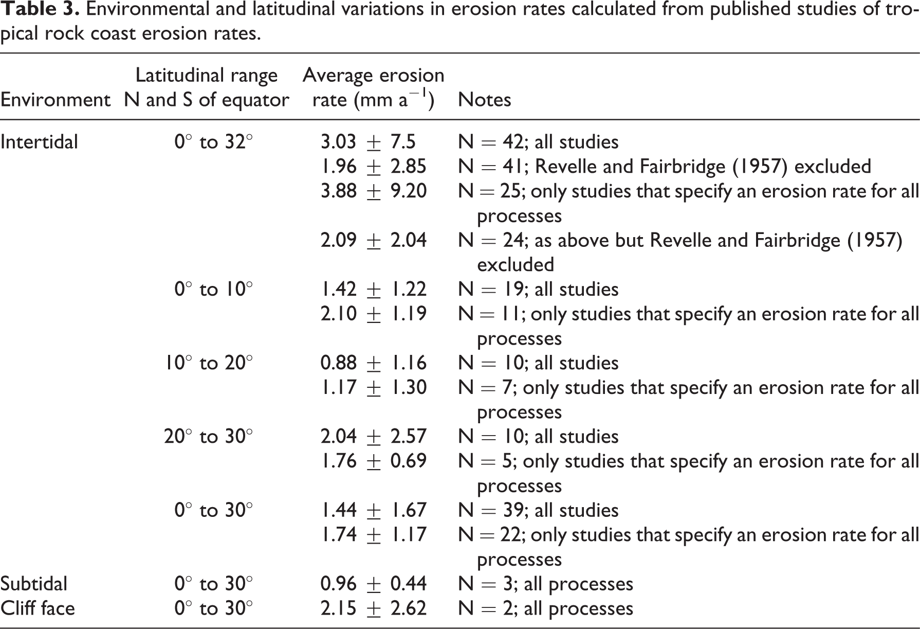
Table 3 presents, for different latitudinal bands, average erosion rates, expressed in mm a−1 and calculated in a variety of ways using available published data. Together, all of the studies over the full latitudinal range included in this paper (up to 32°N and S of the equator) give an average intertidal erosion rate of 3.03 mm a−1 (± 7.50). Exclusion of the unusually large figure provided by Revelle and Fairbridge (1957; Table 2 in this paper) reduces the average to 1.96 ± 2.85 mm a−1. Including only figures from studies that specify erosion rates for all, rather than specific, processes gives an average of 3.88 ± 9.20 mm a−1, which is reduced to 2.09 ± 2.04 mm a−1 by excluding the Revelle and Fairbridge (1957) figure. In comparison, when figures only for studies within 30° of the equator specifying an erosion rate for all processes are included then the average is 1.74 ± 1.17 mm a−1. Average subtidal erosion is 0.96 ± 0.44 mm a−1 and average cliff face erosion 2.15 ± 2.62 mm a−1. The differences between these values are not statistically significant. Intertidal erosion rates appear to vary with latitude but, again, the differences are not statistically significant. Although the majority of rock types are carbonate, the range of methods used to measure erosion over a wide variety of wave energy and tidal settings results in a highly variable data set. Almost all of the studies that measure erosion rates directly are short-term studies. Only Viles and Trudgill (1984) report longer-term MEM measurements recorded over a 13-year period on Aldabra Atoll, Indian Ocean, and discuss comparisons of rates collected over 2- and 11-year periods. Although they found no consistent time trend and cautioned against using short-term data for interpretation and extrapolation, a tendency for the higher, short-term erosion rates to become lower rates in the longer term was noted. This was thought to reflect a cycle of granular disintegration, with periods of rapid grain dislodgement followed by periods of surface stability. Viles and Trudgill (1984) also suggested that a previous interpretation of the short-term results, that the most rapid erosion was in the upper intertidal (Trudgill, 1976), had been erroneous and that erosion focused instead on lower and mid-intertidal wave action and abrasion. Theirs is the only study to have directly measured erosion rates over a time period of at least a decade.
Other studies have measured longer-term erosion rates by measuring surface recession relative to a datum of known age or on the basis of the depth of notch of known age (Table 2). These range from 0.4 mm a−1 to 6 mm a−1 and average 2.0 ± 1.6 mm a−1. Short-term average erosion rates, calculated only from studies that report direct measurements recorded using either erosion pins or an MEM range, is 1.3 ± 0.7 mm a−1 but with values as high as 7.5 mm a−1 (reported by Viles and Trudgill, 1984; Table 2 in this paper). The difference between these longer- and short-term values is not statistically significant. The high variability of the data available from studies of rock coast erosion in the tropics and the lack of published studies reporting directly measured erosion rates since the mid-1980s make it very difficult to examine temporal changes in erosion rates that might be linked to climate change. Average intertidal erosion rates calculated using all published values appear to show a decrease since the mid-1970s, from 2.06 ± 1.55 mm a−1 to 1.28 ± 0.68 mm a−1. Similarly, averages calculated using only studies that report direct measurements also show a reduction from 1.9 ± 1.28 mm a−1 to 1.16 ± 0.79 mm a−1. Neither are statistically significant and so may be only speculatively linked to a climate shift in 1976–1977 when the Pacific Decadal Oscillation (PDO) changed to a warm phase that lasted until at least the mid-1990s; a climate shift that influenced tropical monsoons such that there was an overall decrease in the annual range of rainfall and a decreasing trend in area-average precipitation (IPCC, 2007). Some studies suggest that the reduced storm activity associated with this phase is linked to a reduced coastal sediment movement (e.g. on the coast of Hawaii, central Pacific Ocean; Rooney and Fletcher, 2005). Perhaps a decline in sediment movement has resulted in less intertidal abrasion on rock coasts in the tropics between 1976–1977 and the mid-1990s. Similarly, the decline in annual rainfall may have contributed to a reduced opportunity for mixing-corrosion to occur. There have been no published studies measuring tropical rock coasts erosion since the mid-1980s and so it is not possible to assess the impact of changing storm patterns. It is likely, however, that changes in sea surface temperature and storm activity linked to the El Niño–Southern Oscillation (ENSO) phenomenon in the tropical Pacific Ocean may perhaps increase tropical rock coast erosion in several ways: damage to coral ecosystems may leave rock coasts more exposed to wave attack such that intertidal erosion rates increase, as noted by Spencer (1985b); bioerosion rates may alter, as noted by Spencer and Viles (2002); warmer seas may cause an increase in rate of solution as the rate of carbonate solution is known to increase with temperature (Ford and Williams, 2007).
A more detailed speculation on the possible effects of climate change on tropical rock coasts is beyond the scope of this paper. The average erosion rates presented in Table 3 do, however, have some implications for modelling tropical rock coast evolution. For example, Kogure et al. (2006) have investigated the periodicity of cliff collapse linked to intertidal notch development. On the basis of a notch erosion rate of 1 mm a−1 and cliff failure at a notch depth of 6 m, they predicted the periodicity of cliff collapse to be 6000 years. Their predictions were based on notch erosion rates from three studies, only two of which had been conducted on tropical coasts. This paper indicates that notch erosion may be up to three, or four, times faster and so the periodicity of cliff retreat may be less than 2000 years. Similarly, Pirazzoli’s (1986) models of notch development may operate much more rapidly in the tropics, as is shown in Table 1.
Environmental and latitudinal variations in erosion rates calculated from published studies of tropical rock coast erosion rates.
V Concluding remarks
This review has sought to assess the present understanding of the dynamics of tropical rock coasts, specifically rates of development of notches and platforms. This is important in the context of increasing construction in their proximity and for assessing and predicting the impacts of climate change and sea-level rise. There are a number of key findings: first, that sea cliff erosion in the tropics is understudied as there is a dearth of information on erosion rates and dynamics. The majority of studies have focused on the development of intertidal notches rather than either the cliffs that may back them or the platforms that may front them. Second, there is considerable scope to improve understanding of the relative contributions of different processes to tropical rock coast erosion rates – not just marine versus subaerial but individual marine processes, such as wave impact and abrasion. If, as Wong (2003) suggests, beach volumes are declining in the tropics, the consequences for rock coast erosion rates are currently unknown. For example, if beach volumes are no longer sufficient to absorb wave energy, thereby protecting the underlying rock, then erosion rates may increase. However, a reduction in beach volumes may mean that there is less sand available for abrasion, thus lowering erosion rates. Alternatively, the lower sand volumes may be more mobile and therefore cause greater abrasion. The potential impact of reduced beach volumes may also depend on the relative importance of solution and biological action, particularly on harder coastal lithologies. Third, understanding of tropical rock coast dynamics is largely limited to relatively young lithologies, such as beachrock and reef limestone. Granite coasts may be special cases, formed by subaerial rather than marine processes, but understanding of the erosion dynamics of other rock types, including basalts and harder sedimentary rocks remains limited for tropical coasts. Finally, there is considerable scope to improve models of tropical rock coast development. Models of tropical intertidal notch development, for example, have been devised predominantly on the basis of studies conducted on limestone coasts and their applicability to other rock types is not known. The extent to which tropical rock coasts are sensitive to changes in climate and associated sea level is not well understood. The fact that published rates are from different sites, often from quite different rock types and measured using methods of highly variable accuracy, together with the lack of studies quantifying erosion rates after the mid-1980s, makes a detailed assessment difficult. There remain a number of challenging and unanswered questions about the erosion dynamics and evolution of rock coasts in the tropics. A comprehensive longer-term monitoring programme on a range of lithologies would help to fill some of the knowledge gaps and help to begin to answer some of these questions.
Footnotes
Acknowledgements
The author would like to thank John Barlow and David Robinson for comments on an earlier draft and Della Murton for drawing the diagrams. Reviews by Alan Trenhaile, Stephen Trudgill and Heather Viles helped to broaden the scope of the paper.
Funding
This research received no specific grant from any funding agency in the public, commercial, or not-for-profit sectors.