
Abstract
Understanding Greenland ice sheet (GrIS) hydrology is essential for evaluating response of ice dynamics to a warming climate and future contributions to global sea level rise. Recently observed increases in temperature and melt extent over the GrIS have prompted numerous remote sensing, modeling, and field studies gauging the response of the ice sheet and outlet glaciers to increasing meltwater input, providing a quickly growing body of literature describing seasonal and annual development of the GrIS hydrologic system. This system is characterized by supraglacial streams and lakes that drain through moulins, providing an influx of meltwater into englacial and subglacial environments that increases basal sliding speeds of outlet glaciers in the short term. However, englacial and subglacial drainage systems may adjust to efficiently drain increased meltwater without significant changes to ice dynamics over seasonal and annual scales. Both proglacial rivers originating from land-terminating glaciers and subglacial conduits under marine-terminating glaciers represent direct meltwater outputs in the form of fjord sediment plumes, visible in remotely sensed imagery. This review provides the current state of knowledge on GrIS surface water hydrology, following ice sheet surface meltwater production and transport via supra-, en-, sub-, and proglacial processes to final meltwater export to the ocean. With continued efforts targeting both process-level and systems analysis of the hydrologic system, the larger picture of how future changes in Greenland hydrology will affect ice sheet glacier dynamics and ultimately global sea level rise can be advanced.
Keywords
I Introduction
The Greenland ice sheet (GrIS) has been experiencing increasing surface melt (Bhattacharya et al., 2009; Box, 2013; Fettweis et al., 2011) and accelerated freshwater runoff to the ocean (Dyurgerov et al., 2010), contributing to global sea level rise (Bamber and Riva, 2010; Rignot et al., 2011; Shepherd and Wingham, 2007; Shepherd et al., 2012) and influencing estuarine and ocean circulation (Bamber et al., 2012; Fichefet, 2003; Marsh et al., 2010; Straneo et al., 2010). While understanding of recent meltwater contributions to the ocean has become clearer due to an increase in available data from satellite remote sensing, projecting plausible future scenarios remains highly uncertain because of a lack of understanding of the processes that control sea level rise, particularly an unstable ice sheet (Milne et al., 2009; Nicholls and Cazenave, 2010). Paleoclimatic reconstructions have shown contribution of meltwater amounting to sea levels that are meters above modern sea level in response to modest warming, with peak rates possibly exceeding 1 m/century, cautioning that the rate of future melting and sea level rise may be much higher than currently thought (Overpeck et al., 2006). However, studies have also shown that glaciological conditions required for such a large increase in sea level are unlikely (Pfeffer, 2011; Pfeffer et al., 2008), and estimate that Greenland’s contribution to sea level rise by the end of this century will be ∼22 cm (Bindschadler et al., 2013), with a possible rate of ∼0.7–0.8 mm/yr (Fettweis et al., 2008). A large unknown in such projections is the role of meltwater: how it contributes to dynamic changes in outlet glaciers and what fraction of meltwater produced on the surface of the GrIS becomes runoff into the ocean (Rennermalm et al., 2013a).
Ice sheet surface melting has been observed through automatic weather stations (AWS) on the ice surface and through remote sensing, employing radar and thermal data to detect surface and/or near-surface presence of meltwater or surface temperatures above the melting point. Melt records from the satellite era have shown positive trends in melt extent since 1972 (Abdalati and Steffen, 2001; Mernild et al., 2011b; Mote, 2007) and a pronounced trend in winter surface temperatures (Box, 2013; Hall et al., 2008; Hanna et al., 2012; van As, 2011). Models combined with AWS data have shown an overall dominant warming since 1840, with a cooling period from 1932 to 1992, and a very significant warming trend since 1994 attributed to intensifying anthropogenic warming and decreasing sulfate cooling from volcanic eruptions (Box, 2013). Additionally, this recent warming trend began with a step-like increase of both melt extent and temperature coinciding with a sign reversal in the North Atlantic Oscillation (NAO) index (Bhattacharya et al., 2009). The increase in melt extent has been dominated by strong warming in the western GrIS rather than the eastern portion (Abdalati and Steffen, 2001; Hanna et al., 2012; Steffen and Box, 2001), with the northwestern sector showing the highest annual trend in surface temperature (Hall et al., 2013; van As, 2011). Over the period 1982–2011, observations at Summit, Greenland, suggest a warming rate six times the global average (McGrath et al., 2013). Satellite data have shown a string of record-setting years in the recent decade, from the melt anomalies of 2002, 2007, and 2010 (Mernild et al., 2011b; Mote, 2007; Steffen et al., 2004; Tedesco et al., 2008) to the most recent extreme 2012 melt event that covered 98% of the GrIS surface (Bennartz et al., 2013; Hall et al., 2013; Nghiem et al., 2012; Tedesco et al., 2013).
Mass of the GrIS is gained from snowfall and lost by melt and iceberg calving. Surface mass balance (SMB) refers to mass exchanges at the surface of the ice sheet, where accumulation occurs through snowfall as well as refreezing of meltwater, and ablation of the surface consists of melt as well as sublimation. Mass balance measurements quantify these processes and are directly linked to the meteorological parameters that govern accumulation and ablation. While SMB varies spatially, a broad upper region of mass surplus is the accumulation zone, and a broad lower region of mass deficit is the ablation zone, with the boundary between the two zones defined as the equilibrium line altitude (ELA; Figure 1). Together, SMB and ice discharge through calving represent total mass balance, which has become increasingly negative, driven by two main components increasing dramatically in the first decade of the 21st century: ice discharge and melt (Allison et al., 2009; van den Broeke et al., 2009). While interannual variability in mass balance is mostly accounted for by variation in accumulation through precipitation, anomalies in ice discharge and meltwater runoff significantly exceed decadal variability of precipitation. These anomalies led to a general trend of mass loss (Sasgen et al., 2012; van den Broeke et al., 2009), yet consensus on exactly how much mass has been lost has not been reached, due to different accounting methodologies and varying time spans (Cazenave, 2006; Shepherd et al., 2012; Vernon et al., 2013).

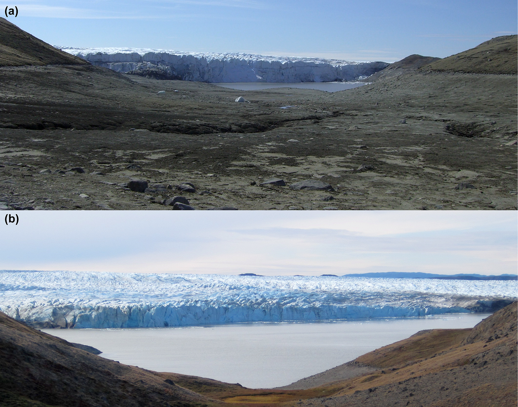
Elements of the Greenland ice sheet hydrologic system. (a) In the accumulation zone above the equilibrium line altitude (ELA), water percolating through the snow/firn can pool into slush regions and channelize into supraglacial streams. In the ablation zone beneath the ELA, meltwater pools in supraglacial lakes and flows through streams into crevasses and moulins, entering englacial and subglacial conduits emerging into proglacial rivers and lakes. As meltwater moves through the system, erosional debris increases sediment concentration making glacial-melt lakes and rivers sediment-rich (leaving precipitation and snowmelt lakes clear of sediment). Finally, meltwater entering the ocean produces a buoyant sediment plume in the fjord. (b) Differences for marine-terminating glaciers lie in meltwater outlet mechanisms. Sediment-rich subglacial discharge released tens to hundreds of meters below the water surface either rises to form a buoyant plume or forms a turbidity current beneath the surface.
New satellite measurements have allowed a more robust understanding of Greenland SMB and ice discharge. In particular, gravimetry measurements from the Gravity Recovery and Climate Experiment (GRACE) provide observations of mass loss independent of other remote sensing estimates and models (Cazenave et al., 2009; Chen et al., 2006; Harig and Simons, 2012; Velicogna, 2009; Velicogna and Wahr, 2005; Wouters et al., 2008), and have shown agreement with other assessments (Rignot et al., 2011; Shepherd et al., 2012; van den Broeke et al., 2009). From 2002 to 2011, the GrIS experienced an average –240±18 Gt/yr of ice mass loss as measured by GRACE, similar to the –240±18 Gt/yr from modeled SMB and remotely sensed ice discharge (Sasgen et al., 2012). Increasing accumulation in the ice sheet interior and southeast (Box et al., 2006; Burgess et al., 2010; Miège et al., 2013) has mostly been exceeded by losses in the marginal ablation zone (Ettema et al., 2009; Luthcke et al., 2006; Zwally et al., 2011). Further supporting that mass loss is regionally dominated by different components, two regions with high rates of mass loss show very different characteristics: the southeast is dominated by ice discharge and the southwest by melting and runoff (Sasgen et al., 2012; van den Broeke et al., 2011). Each remotely sensed or modeled mass loss component contains large uncertainties, and therefore it is important to partition mass loss into an ice dynamics component and meltwater runoff component, particularly for regional analyses.
Dynamic changes to outlet glacier velocity, calving rate, and ice thickness are main contributors to increasing GrIS mass losses. Losses are exponentially higher at the margin (van de Wal et al., 2008) with rapid thinning of both outlet glaciers and the ice sheet itself (Krabill, 2004; Pritchard et al., 2009; Thomas et al., 2009). Outlet glaciers are categorized into land-terminating glaciers and marine-terminating glaciers, most of which lie in deep channels with beds below sea level and end either as a floating glacier tongue or by joining an ice shelf (Cuffey and Paterson, 2010). Marine-terminating outlet glaciers have shown increases in total ice discharge (Howat et al., 2007; Rignot, 2004) and velocity (Moon et al., 2012; Rignot and Kanagaratnam, 2006), with velocity speedups recently extending to the northwest (Khan et al., 2010). Ocean interactions with marine-terminating glaciers include destabilized calving fronts (Nick et al., 2010; Thomas, 2004) and enhanced ice-bottom melting from warm ocean waters (Holland et al., 2008; Rignot and Steffen, 2008). These dynamic changes to outlet glaciers and the GrIS margin are primary concerns for modeling reasonable projections of future mass losses. Possible feedbacks from increasing meltwater input could further accelerate mass loss, but meltwater transport processes are much less studied than changes in outlet glacier velocity, ice discharge, and thickness.
Meltwater runoff possibly accounts for more than half of GrIS mass loss (Sasgen et al., 2012; van den Broeke et al., 2009), yet the complex pathways transporting meltwater from the ice sheet surface to the ice edge and the ocean are still not well understood. Runoff is important for ice sheet mass loss as direct input to sea level rise, but also in its interaction with englacial and subglacial channels, affecting ice dynamics (Bartholomew et al., 2012). Remote sensing provides robust measures of meltwater production on the ice surface, showing increasing melt extent and intensity over the last decade (Bhattacharya et al., 2009; Fettweis et al., 2011; Mernild et al., 2011b; Mote, 2007; Tedesco et al., 2011), but models are still required to account for complete surface energy balance and to fully explain the process of meltwater becoming runoff. Model variation in accounting for meltwater retention and refreezing in firn complicates estimates of true runoff from the ice sheet (Bøggild et al., 2005; Pfeffer and Meier, 1991; Reijmer et al., 2012). Models have shown increased runoff from regional drainage basins as well as for the entire ice sheet over the last half-century (Box, 2013; Box et al., 2006; Dyurgerov et al., 2010; Ettema et al., 2009; Mernild et al., 2008, 2010a, 2010b), yet significant increases in runoff have mostly been offset by increased precipitation in mass balance estimates (Hanna, 2005; Hanna et al., 2008). However, projections of 21st-century mass balance show that runoff increases may exceed increased precipitation (Tedesco and Fettweis, 2012). A key and unknown process scientists seek to understand is how increased meltwater input into englacial and subglacial drainage systems affects ice dynamics.
Changes in meltwater input to englacial and subglacial environments are widely shown to be related to ice dynamics, and questions remain about how changing meltwater input volumes affect englacial and subglacial network organization. Short-term speedups of both land-terminating portions of the ice sheet (Bartholomew et al., 2010; Palmer et al., 2011; Zwally et al., 2002) and fast-moving marine-terminating outlet glaciers (Andersen et al., 2011; Joughin et al., 2008b; Shepherd et al., 2009) have been observed following increased meltwater production as well as from rapid drainage of supraglacial lakes (e.g. Das et al., 2008). These observations prompted the hypothesis that increased ice sheet surface meltwater entering the subglacial environment can increase glacier flow through basal lubrication of the ice-bedrock interface (e.g. Zwally et al., 2002). Basal sliding is tied to englacial and subglacial drainage organization. Less developed subglacial networks are inefficient at draining large volumes of meltwater and can be overwhelmed to cause short-term increases in ice motion (Colgan et al., 2011a). However, examination of drainage network development throughout the melt season shows greater drainage efficiency as subglacial conduits develop with increasing meltwater input, causing instead decreased basal sliding, as inferred from observations of velocities responding to seasonal melting (Schoof, 2010; Sundal et al., 2011). With discrete meltwater pulses shown to increase short-term basal sliding, yet seasonal increases in meltwater production shown to decrease basal sliding, the question of how ice dynamics will respond to future warming scenarios is tied to englacial and subglacial drainage organization and development.
Meltwater produced on the ice surface is transported from its origin in a variety of ways. Meltwater can move through supraglacial stream networks and lakes and potentially connect to englacial and subglacial pathways through moulins and crevasses that drain supraglacial water features. Alternatively, meltwater that is not routed from the surface can be retained through refreezing or become stored interannually in supraglacial lakes and water-filled fractures (Figure 1). Supraglacial lakes have gained widespread scientific interest with their propensity to drain rapidly into the ice sheet and trigger short-term velocity changes and sustained uplift (Das et al., 2008; Doyle et al., 2013). To this end, numerous studies have mapped the occurrence and seasonal evolution of supraglacial lakes and have modeled lake depth and volume (Banwell et al., 2012; Box and Ski, 2007; Chu et al., 2009; Fitzpatrick et al., 2013; Georgiou et al., 2009; Hoffman et al., 2011; Johansson and Brown, 2012; Krawczynski et al., 2009; Lampkin, 2011; Leeson et al., 2012; Liang et al., 2012; Lüthje et al., 2006; McMillan et al., 2007; Selmes et al., 2011; Sneed and Hamilton, 2007; Sundal et al., 2009; Tedesco and Steiner, 2011; Tedesco et al., 2012). Supraglacial streams are a dominant feature of the GrIS ablation zone and can deliver a constant supply of water to moulins during the melt season, thereby playing an important role in contributing water to the englacial and subglacial environments. Despite the importance of supraglacial streams in understanding ice sheet hydrology, they remain poorly studied due to inadequate spatial resolutions of available satellite imagery and logistical difficulty in obtaining spatially varied in situ measurements of stream properties. Crucial to addressing the proportion of meltwater moving off the ice sheet is a review of the progress made in understanding processes of meltwater generation, retention, and export.
This paper summarizes the current understanding of the GrIS surface water hydrologic system, with an emphasis on recent findings and highlighting remaining gaps in knowledge. Supraglacial hydrology, in particular, is given the most thorough treatment as it is the area of research with the most to gain from new satellite data. There are a number of thorough reviews of glacial hydrology for various types of glaciers and for various components therein, including alpine glaciers (Fountain and Walder, 1998; Hooke, 1989; Hybbard and Nienow, 1997), polythermal glaciers (Irvine-Fynn et al., 2011b), water-filled englacial channels known as Röthlisberger channels (Walder, 2010), jökulhlaups (Björnsson, 2010; Roberts, 2005), glacier storage (Jansson et al., 2003), calving (van der Veen, 2002), subglacial water in ice sheets (Bell, 2008), and melt-induced influences on dynamics of the GrIS (Mair, 2012). None of these reviews focuses uniquely on GrIS hydrology as a system, and the emphasis on the linkages between supraglacial and proglacial environments presented here, essentially a ‘snow-to-sea’ approach, is particularly novel. A recent article argues for the importance of studying various components of the GrIS hydrology as a multi-scaled system (Rennermalm et al., 2013a), and this review assesses the current state of knowledge of GrIS hydrology in a similar fashion with the following structure: ice sheet surface meltwater production (section II); supraglacial storage and drainage (section III); englacial and subglacial networks and conduits (section IV); ice dynamics (section V); proglacial environments (section VI); and ocean interactions with meltwater runoff and outlet glaciers (section VII).
II Ice sheet surface meltwater production
Melting of snow and ice, driven by the net flux of energy from the atmosphere to the ice sheet surface, primarily accounts for ablation of the GrIS. The ablation zone is where the ice sheet surface loses mass by the end of the year and generates meltwater runoff. Surface melt that occurs in the accumulation zone can infiltrate through snow and firn to either refreeze or possibly become runoff. Firn is snow that has survived for at least a year, an intermediate step between newly fallen unsaturated snow and glacier ice. The accumulation zone can be categorized into three typical glacier facies with varying hydrologic processes: (1) the dry snow zone where no melting occurs in the interior; (2) the percolation zone, where surface meltwater percolates into snow and firn before refreezing; and (3) the wet snow zone, where all the snow deposited since the previous summer has warmed to 0°C by the end of the melt season. In the lower wet snow zone, meltwater can pool into slush regions beneath the slush limit, the highest point from which mass escapes the glacier as flowing water (Figure 1; Cuffey and Paterson, 2010). Size and distribution of different facies are governed by elevation, seasonal progression, and annual variations in accumulation and melt extent.
Surface meltwater production is given by the energy balance at the ice sheet surface:

where
Melting of the snowpack increases snow grain size, in turn decreasing surface albedo, and further enhancing melting in a feedback mechanism, which has been demonstrated over 97% of the GrIS and can account for more than half of the overall increase in melting (Box et al., 2012; Tedesco et al., 2011). Decreased surface albedo, resulting from both the temperature-albedo feedback and the presence of dust, can enhance melting rates and increase runoff. As snow melts, the ice surface is exposed, and this darker ice surface has a lower albedo that increases the amount of solar energy absorbed, thereby further decreasing albedo through increased meltwater production. This feedback between meltwater accumulation and decreased albedo corresponds to a darkening of the GrIS surface in the late summer (Greuell, 2000). GrIS surface darkening is also strikingly visible as dark wavy bands seen in the western ablation zone (Figure 2; Wientjes et al., 2011) and also in the northeast (Bøggild et al., 2010). These bands are caused by seasonal melting of old ice revealing a surface layer of dust previously deposited higher on the ice sheet, with a pattern typical for the outcropping of stratified layers. Deposition of wind-blown dust can also contribute to this debris layer, but is a much smaller source (Wientjes et al., 2011).
Distinct albedo zones on the ice surface, with cleaner high-albedo bare ice on the left contrasting low-albedo bare ice with outcropping dust on the right.
The aggregation of dust particles can form clusters of sediment that enhance ice melt because of lowered albedo and create water-filled cryoconite holes (MacDonell and Fitzsimons, 2008). Studies in other polar regions find that the presence of cryoconite holes represents the transition between a melting ice cover common on temperate and polythermal glaciers and the frozen surface of the interior, with these features contributing to runoff as they grow and lose their isolation, joining in supraglacial stream networks (Fountain et al., 2004; Irvine-Fynn et al., 2011a). Microorganisms flourish in cryoconite holes as the interaction between the sediment and water creates a nutrient source, and, as the organic matter has a high light absorbency, further decreases albedo (Wientjes et al., 2011). These impurities significantly affect the albedo of the GrIS surface, with uniform dust layers showing albedos of ∼0.3 and large cryoconite holes showing albedos of ∼0.1 (Bøggild et al., 2010). The potential for dust and biotic factors to enhance melting via reduction in albedo is still an important unknown and will greatly affect modeled estimates of meltwater production (Stibal et al., 2012).
Complex firn processes of melting and refreezing govern the proportion of surface meltwater production that becomes meltwater runoff. As the melting season progresses, metamorphic processes transform firn into ice, thereby closing void spaces and turning permeable firn into a layer impermeable to water flow. Competing processes of pore refreezing from vertical flow and superimposed ice formation from refreezing of horizontal water flow both contribute to water storage (Bøggild et al., 2005; Humphrey et al., 2012). The percolation zone is a region of high interest for studying initiation of runoff, and is where much of the increased surface melt is occurring. While perennially covered by snow and firn, surface meltwater can penetrate depths of 10 m or more of cold firn and can persist for many months to either refreeze or migrate down-glacier to become runoff (Humphrey et al., 2012). Generally, water at higher elevations percolating into underlying subfreezing firn will refreeze, releasing latent heat and raising the temperature of the firn to the point where meltwater can start to percolate and drain freely. Below the ELA, firn that becomes superimposed ice is thus melted twice before running off. If this is not accounted for in modeling the energy expenditure on the surface, models will show much more water leaving the system than is actually observed (Cuffey and Paterson, 2010).
Another aspect of meltwater retention is firn densification, which reduces firn volume but increases its density, and increases with time and depth. This process is mainly controlled by meltwater refreezing that intensifies with both increasing mean annual temperature and accumulation rate (Braithwaite and Laternser, 1994; Hörhold et al., 2011). Field studies have found considerable meltwater infiltration contributing to densification in the percolation zone (Brown et al., 2012), and modeling shows highest possible retention in the lower percolation zone and the wet snow zone near the ELA (Fausto et al., 2009). Translating short-term elevation changes into mass changes can be misleading without accounting for densification (Reeh, 2008), and future predictions of sea level rise can overestimate levels by 5 cm over 150 years without incorporating refreezing process (Pfeffer and Meier, 1991).
While meltwater percolation and refreezing can release heat to warm the surrounding snow and firn at the beginning of the melt season, meltwater may also cause a sustained warming on ice temperatures when it does not completely refreeze during the winter, in a process known as cryo-hydrologic warming (Phillips et al., 2010). This provides a mechanism for rapid thermal response of the GrIS to climate warming. Phillips et al. (2013) included this mechanism in their model of ice velocity and showed that increased velocities in the southern Greenland inland wet snow zone over 2001–2007 matched observations better than without cryo-hydrologic warming built in. This ice speedup is due to an increase in the extent of basal sliding permitted by temperate bed conditions (Phillips et al., 2013), which adds another mechanism by which a warming climate may affect ice dynamics.
III Supraglacial storage and drainage
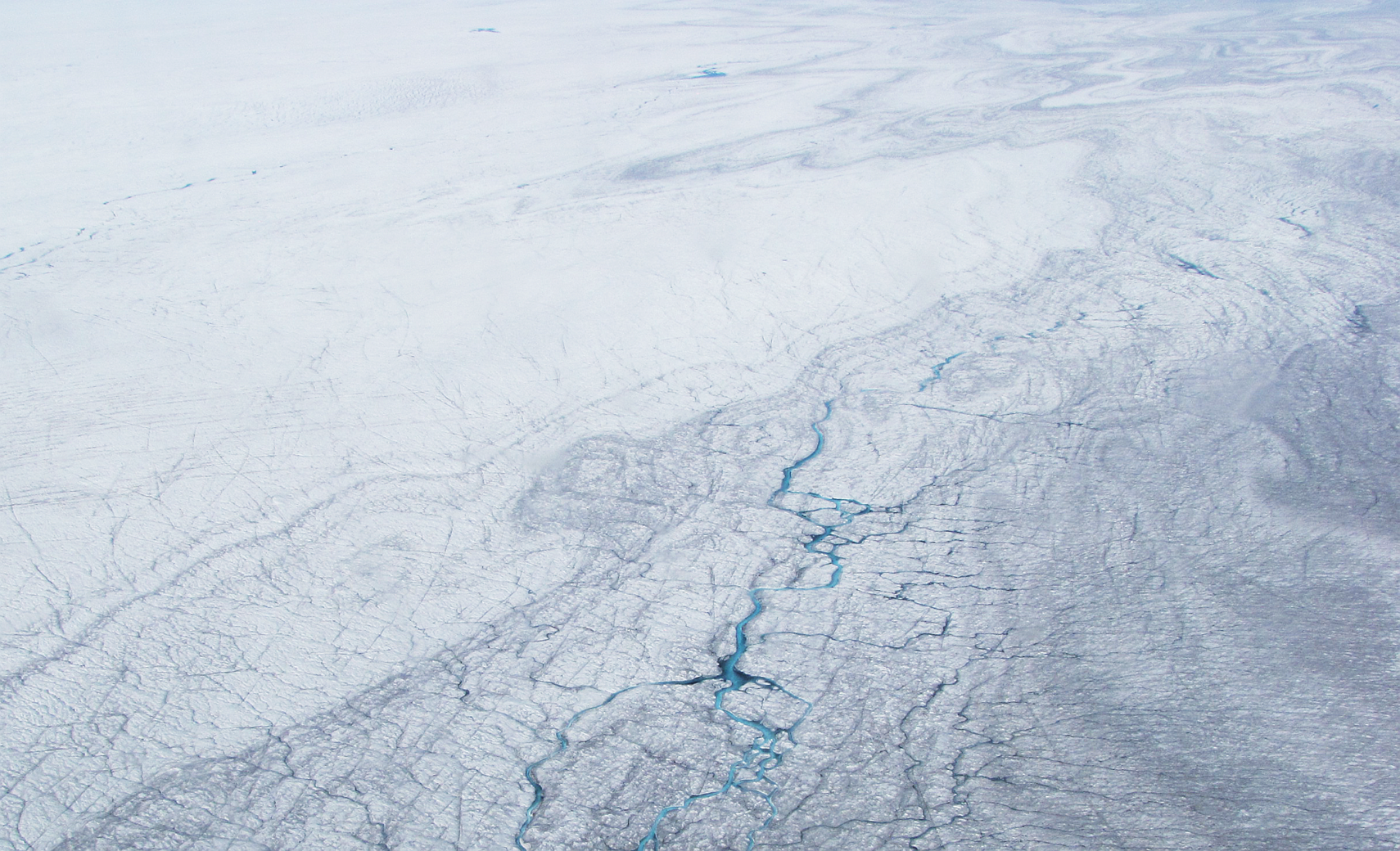
Surface meltwater generated at the beginning of the melt season percolates through snow and firn to refreeze at depth. This process of percolation and refreezing increases the rate of transformation from surrounding snow and firn to ice, and gradually forms a saturated firn layer. Low relief areas accumulating meltwater when thin firn saturates to the surface forms slush zones and supraglacial lakes. This water storage may feed arborescent stream networks as channels incise and connect, representing a change from a system dominated by water percolation to a system dominated by channelized stream flow, punctuated by ponding lakes and drainage into the ice sheet through fractures and moulins (Figure 1). Satellite images show the western ablation zone littered with supraglacial melt ponds and dense networks of streams developing throughout the melt season (Figure 3). While the role of supraglacial lakes and streams as temporary storage for meltwater is important for diurnal and seasonal hydrologic cycles, sudden drainage of lakes and streamflow through cracks and moulins plays an important role in rapidly transporting meltwater into the GrIS. Understanding the spatial distribution and seasonal progression of these hydrologic features is an ongoing process of mapping and modeling with increasingly finer resolutions and greater spatial coverage, allowing for a broader understanding of ice sheet-wide reactions to increased melting.

The supraglacial hydrologic network in the southwest GrIS ablation zone showing supraglacial streams flowing into a lake, with a large output stream to the left of the image.
1 Supraglacial lakes
Meltwater can pond in depressions over imper-meable ice or dense firn to establish supraglacial lakes that appear over multiple years in the same locations and can inject large amounts of meltwater into the ice sheet through fast drainage events. Supraglacial lakes tend to reform in the same locations over the lower ablation zone from year to year, with seasonal progression showing lake formation at progressively higher elevations as well as increasing lake drainage frequency in lower elevations. Numerous studies have mapped the occurrence and seasonal evolution of lakes in various regions, with the high temporal resolution of MODIS playing a pivotal role in examining lake dynamics (Box and Ski, 2007; Chu et al., 2009; Fitzpatrick et al., 2013; Leeson et al., 2012; Liang et al., 2012; Selmes et al., 2011; Sundal et al., 2009). These studies have shown that lake location and area are driven by time of season, elevation, and topography (Lüthje et al., 2006): numerous small lakes cluster in low elevations near the margin (but above crevasse fields); large lakes form in the same locations over multiple years at higher elevations (∼1000–1200 m) and are less clustered; and sparse underdeveloped lakes form above ∼1200 m (Lampkin, 2011; Liang et al., 2012). Since lake area is more controlled by topography than melt rate, lake development will likely accelerate in a warmer climate because of melting at higher elevations where surface slopes are small (Lüthje et al., 2006). Tracking lake development and drainage, especially in the context of a warming climate, is crucial for assessing lake importance in meltwater storage and transport.
Interest in supraglacial lakes has been particularly high since 2006, with numerous studies on lake distribution and drainage showing their importance in delivering large quantities of meltwater to the englacial and subglacial systems, causing short-term velocity changes and sustained uplift (Bartholomew et al., 2011a; Box and Ski, 2007; Das et al., 2008; Doyle et al., 2013; Hoffman et al., 2011; Palmer et al., 2011). Das et al. (2008) provided the first known observation of a meltwater pathway through thick, cold ice, showing that a lake emptying with a drainage rate of 8700 m3/s resulted in uplift and ice velocity increases within 24 hours. Additionally, Doyle et al. (2013) showed that horizontal ice motion during rapid lake drainage is dominated by ice tectonic deformation related to the opening and closing of multiple fractures. In a study tracking lake area in three regions (southwest, north, and northeast), Sundal et al. (2009) found a high correlation between annual peak total lake area and modeled annual runoff. However, Selmes et al. (2011) also tracked rapidly draining lakes for the entire GrIS and showed an inverse relationship between the occurrence of rapid drainages and regional mass loss, indicating that dynamic mass losses in the southeast and northwest have little to do with rapid lake drainages (Figure 4). For example, the southeast has relatively few, small lakes, yet exhibits significant mass loss, possibly explained by steep slopes (Selmes et al., 2011; Sundal et al., 2009). These studies have advanced our knowledge of supraglacial lakes as a mechanism for rapid response to surface meltwater changes that increase short-term ice velocities through decreased basal friction, discussed further in section V.

Distribution of lakes and rapid drainage events over 2005–2009 from MODIS satellite imagery. The total area of lakes (dark gray) and total area of lakes that drained suddenly (light gray) are mapped for six regions of the GrIS (circles show mean area). Bar plots show interannual variation with melt intensity superimposed.
Assessing the potential storage or influx of meltwater into the ice sheet through rapid drainage requires modeling lake depth and volume. Algorithms range from physically based retrievals of lake bathymetry (Georgiou et al., 2009; McMillan et al., 2007; Sneed and Hamilton, 2007; Tedesco and Steiner, 2011) to empirical models relating remotely sensed reflectance to depth (Box and Ski, 2007; Fitzpatrick et al., 2013). Lake bottom melting rates are partly controlled by albedo, and a positive feedback from increased water depth reduces lake surface albedo, increasing shortwave radiation absorption. The ablation beneath lakes is estimated to be ∼100–116% greater than the nearby bare ice from in situ measurements (Tedesco et al., 2012) and ∼110–170% from models (Lüthje et al., 2006). Typical assumptions of a homogenous ice substrate and therefore uniform bottom albedo within a lake and for all lakes (Sneed and Hamilton, 2007) have been shown to be very limiting due to the presence of dark cryoconite (Tedesco and Steiner, 2011), and this is a caveat of many reflectance-depth parameterizations (Box and Ski, 2007).
To understand how much water is necessary to initiate the process of lake drainage, studies have found that lake diameters between 0.25 and 0.8 km (Krawczynski et al., 2009) and lake volumes of at least 31.5×10⁶ m3 (Box and Ski, 2007) contain sufficient water to hydrofracture through ice. However, this does not indicate that there exists a critical lake volume threshold to initiate rapid drainage, and Fitzpatrick et al. (2013) found that lake size does not influence its drainage mechanism.
2 Supraglacial streams
The understanding of supraglacial streams presented in this section primarily originates from studies of glaciers, as limited research has occurred on streams of the GrIS. Supraglacial streams form when meltwater incises surface channels once thermal erosion exceeds surface ablation. From early season ponding of water in lakes and slush, meltwater in areas of higher slope drains down-glacier through the snowpack, forming rills that combine into channels, progressing towards more efficient transport in an arborescent network as more ice is exposed and channels are enlarged (Cuffey and Paterson, 2010). Contributions to stream runoff include flows from saturated slush and channel erosion, precipitation, surface melting, and spillover from water-filled moulins, crevasses, and supraglacial lakes (Marston, 1983). Factors distinguishing supraglacial streams from terrestrial streams are the lack of available sediment, rapid form adjustment, and thermal and frictional melting of a channel that add to its discharge (Knighton, 1981). Particularly unusual is the fact that discharge rapidly increases downstream due to both inflow from tributaries and melting of the channel, but is also highly variable because of complex drainage patterns and seepage from streams not deeply incised (Knighton, 1981).
The dependence on ice and snow melt allows stream discharge to show a very pronounced diurnal cycle compared to terrestrial streams, with a rapid decline in streamflow at low sun angles (Ferguson, 1973; Knighton, 1972, 1985). High discharge in the beginning of the melting season can prompt meanders to develop as well as modify existing channels (Ferguson, 1973), but if channels survive for more than a year discharge may not be as important in channel morphology (Hambrey, 1977). Streams are either annual, forming each year, or perennial, reforming in the same channels over multiple years (McGrath et al., 2011). Perennial streams are typically large, incised streams that are covered in snow bridges at the beginning of the melt season with a main trunk width of ∼1–30 m (Knighton, 1981; Yang and Smith, 2013). While supraglacial streams are unique in carrying little or no sediment load on surfaces without debris (the glacier margin is an exception), streams do carry an ice load that could influence flow behavior, but very little research has been conducted on its effects (Knighton, 1985).
Stream formation is initiated when down-cutting by surface channels exceeds surface ablation rates. Channel incision is driven mostly by thermal erosion, but 25–50% is forced by shortwave radiation and sensible heat flux, with stream temperatures as low as 0.005–0.01°C able to incise channels at rates of 3.8–5.8 cm/day (Marston, 1983). The main parameters that drive channel incision rates are temperature loss to the ice, meltwater discharge, and channel slope (Jarosch and Gudmundsson, 2012). A theoretical treatment of channel incision rate for water-filled channels with round cross-sections is shown in Isenko et al. (2005) as:
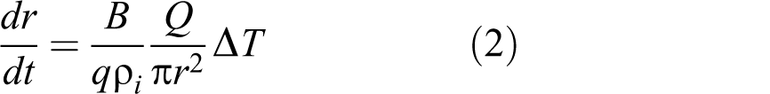
where dr is the thickness of melted ice, B equals 2.64×10³ J/m3/K for turbulent flow at 0°C, q is the latent heat of melting (3.35×10⁵ J/kg), ρi
is the ice density, Q is discharge, r is the channel radius (of the round cross-section), and T is temperature. This formulation focuses on changes in incision rate due to changes in temperature. Another estimate of incision rate of supraglacial channels is presented in Fountain and Walder (1998):
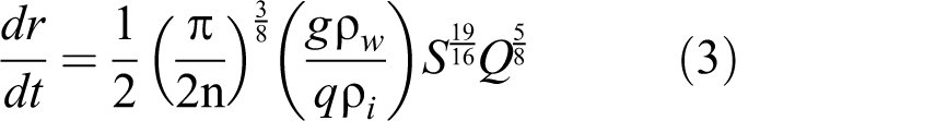
where n is Manning’s roughness (∼0.01 s/m1/3 for ice), g = 9.8m/s2, ρw is the water density, and S is slope. This treatment does not take into account ice deformation and vertical ice motion, but calculations using typical glacier values for n and S show that incision rates are proportional to Q0.6 (Fountain and Walder, 1998).
Hydraulic geometry is an empirical theory linking changes in width (w), depth (d), and velocity (v) both downstream and at cross-sections to discharge (Q) (e.g. Kostrzewski and Zwolinski, 1995; Leopold and Maddock, 1953):

where
The majority of studies conducting extensive supraglacial field measurements over time outside the GrIS focus on meandering tendency and channel incision, comparing them to alluvial streams (Hambrey, 1977). Despite differences from alluvial streams, particularly the ability to rapidly adjust stream form and the lack of sediment load, Knighton (1972) found a general similarity between the form of meanders developed in alluvial valleys and on ice, indicating the larger importance of hydrodynamics in meander formation. This is echoed by Parker (1975), showing that while hydrodynamic considerations alone cannot produce meandering in alluvial rivers without sediment transport, meandering in supraglacial streams can occur as long as flow is supercritical. Straight channels are restricted to areas with strong structural control from cracks and crevasses or very steep glacier slopes (Marston, 1983). Channel roughness in supraglacial streams, indicated by Manning’s n, is generally lower compared to terrestrial streams, but the wide range of values (0.14–0.39; Kostrzewski and Zwolinski, 1995; Marston, 1983) calls into question the characterization of supraglacial streams as homogeneous and smooth, specifically with a Manning’s n value of 0.01 typically used for modeling supraglacial stream flow (Irvine-Fynn et al., 2011b).
Understanding stream processes on the GrIS has not been a priority in remote sensing or field studies until very recently. While there are numerous field studies of supraglacial streams on Arctic glaciers (Dozier, 1976; Knighton, 1972; Marston, 1983) or in the laboratory (Isenko et al., 2005), very few exist for the GrIS. McGrath et al. (2011) provided a detailed study of one moulin-drained stream catchment in the Sermeq Avannarleq region of western Greenland, with a main stream of 1–4 m in width, 1–6 m in depth, and incision rate of 3.3±0.47 cm/day over the 15-day study period in August 2009. In modeling the mass budget of the basin, moulin drainage was found to comprise 52% of the total water output (McGrath et al., 2011). Small-scale field studies like this are crucial for understanding meltwater transport processes and fluxes. Mappings of supraglacial streams have not been attempted until recently due to the limitations in satellite spatial resolutions. Recent availability of high-resolution commercial satellite imagery, such as WorldView-2 (∼2 m multispectral resolution), over the western GrIS allows mapping streams with widths varying between a meter to tens of meters (Yang and Smith, 2013). As more data become available, providing wider spatial and higher temporal coverage, automated methods to delineate streams will be required (Yang and Smith, 2013) due to the time intensity of manually delineating dense stream networks, which has only been done for small study areas (Colgan et al., 2011b; McGrath et al., 2011).
3 Crevasses and moulins
Crevasses and moulins connect supraglacial and englacial environments, providing pathways for surface water to drain into the ice sheet when intersecting streams and lakes. Crevasses are fractures formed from tension, and their patterns are controlled by the directions of the principal stresses, opening in the direction of maximum tension which is typically perpendicular to a glacier’s longitudinal stress field (Colgan et al., 2011b; Cuffey and Paterson, 2010; van der Veen, 1998). Ice movement can then rotate and bend crevasses depending on velocity gradients. For example, Colgan et al. (2011b) found that crevasse fields near Jakobshavn Isbrae have rotated 45% between 1985 and 2009, possibly due to an acceleration of the glacier that has increased southbound flow at the expense of westbound flow in the area. The study also found a 13% increase in crevasse extent, proposing that the changes in extent and orientation are due to overall thinning and steepening of the western ablation area.
Crevasse fields are abundant in the lower ablation zone and allow for a spatially distributed drainage of meltwater into englacial channels, with drainage rates highly correlated with areal extent (Lampkin et al., 2013). McGrath et al. (2011) found that crevasse drainage accounted for 48% of total meltwater output from a moulin-drained basin at a rate of (1.40±1.13)×104 m3/day, and showed that crevasses dampened the diurnal cycle of meltwater input. This translates to a slower and steadier discharge over the short term compared to rapid meltwater injection from moulins, which has consequences for ice dynamics (McGrath et al., 2011). Since most observations of ice uplift and increased velocity are in response to discrete meltwater from either rapid lake drainage or short-term melt pulses (Bartholomew et al., 2012; Das et al., 2008; Zwally et al., 2002), crevasse-dominated drainage may not result in a similar response. Slower drainage into the englacial and subglacial environments may allow for efficient adjustment of meltwater input, rather than basal sliding from overwhelmed subglacial conduits.
In contrast to the spatially distributed, slower meltwater drainage through crevasse fields, moulins provide rapid, near-vertical drainage of larger upstream areas of surface meltwater into englacial and subglacial systems (McGrath et al., 2011). A crevasse that opens across a supraglacial stream can propagate down to intersect englacial channels, and when the water-filled crevasse closes as it is advected into an area of compression the energy in the meltwater can keep a pathway open and enlarge it into a moulin; in other words, crevasses precondition the ice for moulin formation (Holmlund, 1988). Moulins are also created from episodic supraglacial lake drainages, with fractures beneath lakes possibly breaching the full ice thickness (Das et al., 2008), but are less common (Phillips et al., 2011). In fact, a strong correlation between modeled moulin locations and elevated along-flow tension (which produces crevasse fields) rather than supraglacial lake location shows that moulins are more commonly formed through stream intersection with crevasses rather than forming underneath lakes (Catania et al., 2008). New crevasses can intersect supraglacial streams upstream of existing moulins to form new moulins, and this can occur near-annually, leaving a string of moulins with increasing ages going down-glacier (Holmlund, 1988; McGrath et al., 2011). While modeled crevasse drainage shows dampened diurnal variations, slower transfer times (representing sustained meltwater input), and low meltwater drainage per crevasse, moulins allow for rapid pulses of meltwater draining a large, well-developed catchment (Colgan et al., 2011b; McGrath et al., 2011). This elevates the importance of moulins as an immediate and relatively undampened transfer of water into the ice sheet with a potential to overwhelm the subglacial hydrologic system, causing uplift and increased basal sliding.
Repeat aerial photography and high-resolution satellite imagery are useful in conjunction with digital elevation models (DEM) for tracking crevasse and moulin distributions. Mapped crevasses between 1985 and 2009 in the western ablation zone showed high positional stability as well as little overlap between crevasse fields and areas with supraglacial lakes and streams (Colgan et al., 2011b). Moulin distribution in the same area was modeled using slope, elevation, and aspect, and validated with locations from the field and from high-resolution imagery, showing that moulins occurred with interannual locational stability, between 300 m asl and 800 m asl and a density of ∼12/km2 (Phillips et al., 2011). Using ice-penetrating radar to monitor moulin properties, Catania and Neumann (2010) found that moulins persist for multiple years (average ∼11 years) and drain the volumetric equivalent of multiple lakes per year, possibly contributing to an established network of englacial channels.
IV Englacial and subglacial drainage
Englacial conduits fed by meltwater from crevasses and moulins connect the supraglacial environment to the subglacial network. Similar to the research on supraglacial streams, much of the theory presented here is from studies of other Arctic and temperate glaciers. Supraglacial stream incision and subsequent roof closure by ice deformation has been proposed as a possible mechanism for englacial conduit formation, called cut and closure (Gulley et al., 2009a). Fountain and Walder (1998) describe this process whereby surface channels melt down into the ice very quickly as they steepen; then they reach a point where the steam is so deeply incised that the overlying ice can close above the channel, forming a tunnel. This tunnel, which still has a water source, can continue to deepen and steepen until hitting the bed of an over-deepened basin, which is a topographical depression in the bedrock where a lake would likely form if there was no ice above it. At this point, the channel slope will decrease because the frictional energy of the water can only deepen up-glacier of the bedrock. Finally, a stable channel is established when channel wall melt rates balance ice deformation closure rates.
The theory behind channelized englacial flow was developed by Röthlisberger (1972) and Shreve (1972), establishing that englacial conduits are sustained when meltwater enlargement overcomes the tendency for closure from the inward creep of ice. Their papers also discussed whether englacial networks are fast drainage systems composed of large tunnels or slow drainage systems with distributed networks of linked cavities (Figure 5; Fountain and Walder, 1998; Hooke, 1989). The term Röthlisberger-channel (R-channel) flow has come to represent the physical model of conduit flow through large channels (Röthlisberger, 1972), with conservation of energy describing the balance between a source (frictional dissipation of energy in flowing water) and two sinks (energy absorbed by water and energy that melts ice walls), and conservation of momentum described as the relationship between discharge, channel size, and hydraulic gradient (Walder, 2010).
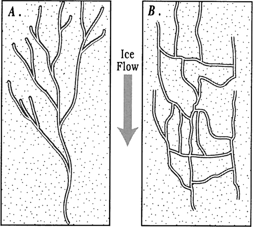
(a) Idealized plan view of a fast arborescent drainage system. (b) A slow non-arborescent drainage system with linked cavities.
Shreve (1972) concluded that the englacial system is an arborescent network of fast flow (consistent with R-channels), likening them to supraglacial channel networks (Irvine-Fynn et al., 2011b; Walder, 2010). Additionally, dye-tracing experiments have shown that there is a rapid transition from distributed to channelized drainage in parts of the drainage system closed by ice deformation in winter (Cowton et al., 2013). However, field studies have shown that these theoretical models of conduit flow may not conform to reality. Boreholes drilled in Storgläciaren, Sweden, predominantly intersect hydraulically connected englacial fracture-like features that are smaller, and with slower water velocities, than traditional conduits, suggesting that englacial water is transported through an interconnected network of fractures rather than large conduits (Fountain et al., 2005). Further field studies are needed to modify theoretical models of englacial drainage.
Englacial conduits can only exist if the tendency for closure, from the inward creep of ice, is balanced by channel enlargement from the energy dissipated by moving meltwater (Fountain and Walder, 1998). While crevasse and moulin propagation can occur without being water-filled as long as the tensile stresses are higher than the ice-overburden stresses, the presence of water allows for more efficient propagation through hydrofracturing. The rate of hydrofracture propagation, u, is controlled by inflow, where a large amount of discharge is needed to maintain water pressure to continue the fracture process (Alley et al., 2005):
Equation (6) describes deepening velocity, u, where Q is discharge, M = 5×10⁹ Pa, df
is fracture depth,

where pw is water pressure, pi is ice-overburden pressure, t is time, and refreezing is not included. Surveys of englacial conduits in various glacial environments show that conduits can only penetrate through thick ice to the bed when intersected by supraglacial water features (Gulley et al., 2009b). Since water flux is more important for propagation than tensile stress, supraglacial lakes and streams become important sources and links for increasing fracture depths to the bed.
High-volume water flow from supraglacial lake drainages and streamflow into moulins can increase pressures and sustain englacial conduits. Lake drainages may be able to drive hydrofractures through thick, cold ice (∼980 km thickness; Das et al., 2008), but large volumes of water are needed for meltwater to penetrate to the bed (Krawczynski et al., 2009). Krawczynski et al. (2009) modeled the water volume and crack geometry necessary to drive cracks through 1–1.5 km of subfreezing ice, and found that lakes larger than ∼0.25 km in diameter are sufficient for hydrofracturing. As a large majority of lakes along the western margin of Greenland are larger than this threshold, there is great potential for rapid transport of water to the bed (Selmes et al., 2011). Dissipation of frictional energy from flowing meltwater converts potential energy to heat such that crevasses and moulins can be maintained and propagated to greater depths. Without continued meltwater input, refreezing and plugging off water at the base of moulins and englacial channels reduce the probability of further downward water propagation (Boon and Sharp, 2003).
Subglacial drainage organization is largely inferred from observations of ice velocity changes in response to seasonal melt input, indicating a seasonal switch from linked cavities to channel-dominated subglacial drainage (Bartholomew et al., 2011b; Chandler et al., 2013; Schoof, 2010; Sundal et al., 2011). Indeed, subglacial drainage systems take on two stable organizations: one of slow flow through linked cavities and another of fast flow through large channels (Bell, 2008; Kamb, 1987). Larger channels will tend to grow at the expense of smaller ones, and linked cavities will coalesce into a less complicated network with fewer, larger conduits (Figure 5A; Hock and Hooke, 1993). However, a sustained water source is needed in order for water pressure to overcome ice-overburden pressure, similar to englacial channels. Measurements of subglacial drainage are highly limited, with only a handful of borehole studies assessing distribution and monitoring networks at a process level. Borehole measurements have shown basal water pressure to be 95% of the ice-overburden pressure, and small changes in basal water pressure can account for almost 40% of a glacier speedup (Sugiyama et al., 2011). Field studies also show that basal crevasses can extend many tens of meters above the bed, enabling them to possibly modulate basal water pressure (Harper et al., 2010).
In contrast to channel development in the englacial environment, channels in the subglacial environment are affected by a debris layer on the bedrock, providing obstacles to flow, and friction between sediment and bedrock. Channels can incise into the bedrock with permeable bed sediments, but hydraulic conductivity is low because of melting under pressure (Fountain and Walder, 1998). Subglacial erosion, measured from sediment fluxes derived from meltwater exiting outlet glaciers, also provides an indicator of surface meltwater contact with the bed. Measurements of subglacial erosion are limited for the GrIS, and previous estimates of ∼0.01 mm/yr from east Greenland (Andrews et al., 1994) are low compared to ∼0.1–10 mm/yr from temperate glaciers (Hallet et al., 1996). However, recent estimates of subglacial erosion rates in west Greenland were found to be 1.6–2.7 mm/yr, a significant increase over previous estimates and suggesting that where surface meltwaters are able to access the bed, the rate of erosion by ice sheets is comparable to rapid erosion observed at temperate alpine glaciers (Cowton et al., 2012). Efficiency of both englacial and subglacial drainage networks are important unknowns affecting the response of ice dynamics to increased meltwater drainage.
V Ice dynamics
Dynamic changes refer to increased ice sheet and outlet glacier velocities that can increase calving, retreat, and thinning, which in turn can enhance melting as ice moves to lower elevations with higher temperatures. Meltwater penetrating to the bed and causing basal sliding and short-term ice velocity speedups is a main mechanism for GrIS surface meltwater to influence ice dynamics. This is one of the greatest concerns for future scenarios of climate change and understanding the GrIS’s contributions to sea level rise, because the possibly non-linear relationship between increased melting and dynamic changes is not given proper treatment in current ice dynamics models (Meehl et al., 2007). The greatest difficulty in assessing current hypotheses of outlet glacier response to increased meltwater input is the lack of field data for training models. While the availability of satellite data allows for estimates of outlet glacier and ice sheet velocities (e.g. Joughin et al., 2010; Moon et al., 2012), questions still remain about the processes driving these velocity changes.
1 Outlet glacier velocity changes and peripheral thinning
Changes in outlet glacier velocities and calving rates are a main contributor to the increasing ice mass losses. Outlet glaciers have shown increases in total ice discharge (Howat et al., 2007; Rignot, 2004) as well as velocity (Rignot and Kanagaratnam, 2006), with velocity speedups recently extending to the northwest (Khan et al., 2010). These dynamic changes to outlet glaciers and the ice sheet margin are the primary concern for modeling reasonable projections of future mass losses because of their unstable nature and possible feedbacks from increasing meltwater input.
Dynamic thinning of both fast-moving outlet glaciers and the general ice sheet periphery is tied directly and indirectly into mass loss. Thinning brings the ice surface to lower elevations with higher temperatures, contributing to a feedback of enhanced melting. Losses are exponentially higher at the margin (van den Broeke et al., 2008) due to rapid thinning of near-coastal outlet glaciers (Csatho et al., 2008; Krabill, 2004; Pritchard et al., 2009; Sole et al., 2011; Thomas et al., 2009). Tracking the ice-front position of Jakobshavn Isbrae to before the satellite era shows intermittent thinning (Thomas, 2004) and periods of ice front retreat. Dynamics of marine-terminating glaciers are highly sensitive to glacier width and bed topography, with wider glaciers grounded over deeper basal depressions tending to be closer to floatation and less sensitive to retreat from thinning (Enderlin et al., 2013). For outlet glaciers with extensive floating tongues, ocean interactions may be more important in driving dynamic changes (see section VII.2).
Velocity changes have shown complex spatial patterns over the last decade, with distinct variations between land-terminating glaciers and marine-terminating glaciers. Sole et al. (2008) found that land-terminating glacial outlets have thinning rates comparable to ablation rates, but marine-terminating glacial outlets experience much higher rates of thinning. Similar results in Pritchard et al. (2009) showed that fast-flowing areas thin more rapidly than slow-flowing areas, particularly in the two areas experiencing highest mass losses: the northwest and southeast. This suggests that thinning of land-terminating glaciers is primarily driven by temperatures, while marine-terminating glaciers are more susceptible to dynamic thinning from changes at the calving front (Sole et al., 2008). Modeling studies, even combined with remote sensing observations, are limited by coarse resolutions and broad scales, making them inadequate for resolving complex behaviors of individual glacier outlets. For example, the scale of most outlet glaciers is small (<5 km width), and means that models cannot accurately represent location topography, fjord water circulation, terminus sea ice, or local climatic variations given the coarse spatial resolution of modeling studies (Moon et al., 2012).
2 Response of ice dynamics to inputs of supraglacial meltwater
Increased meltwater inputs to the ice sheet through surface melting and supraglacial lake drainages have been linked to rapid changes in ice dynamics. Both fast-moving outlet glaciers (Andersen et al., 2010; Joughin et al., 1996, 2008b) and the slower moving ice sheet (Bartholomew et al., 2012; Joughin et al., 2008a; Palmer et al., 2011; Shepherd et al., 2009; van de Wal et al., 2008; Zwally et al., 2002) have shown short-term seasonal speedups in response to enhanced melting or discrete meltwater pulses from lake drainages. Under future warming scenarios, models suggest enhanced sensitivity of ice sheet movement in response to high melting, retreat, and thinning (Parisek and Alley, 2004).
However, other recent studies have alternately hypothesized that basal sliding will not simply increase with more meltwater input despite sensitivity to discrete meltwater pulses. Schoof (2010) modeled subglacial conduit formation and closure in response to meltwater flow and found that water input variability, not just mean input, was the primary driver of short-term glacier velocity increases. This suggests that discrete and rapid meltwater input changes are necessary to trigger a dynamic response, such as those inputs derived from large supraglacial lake drainages or a particularly enhanced diurnal melt cycle (Schoof, 2010; Selmes et al., 2011). Sundal et al. (2011) echoed this argument and found peak velocities positively correlated to melting, yet also found that glaciers slow down after a velocity threshold of 1.4 cm/day is exceeded and that overall speedups over the second half of the summer are 62% slower in warmer years. This slowing effect is not expected if basal lubrication is the primary mechanism by which meltwater interacts with ice dynamics, but instead fits the model of subglacial drainage becoming more efficient, switching from linked cavity to channel drainage systems and reducing melt-induced speedups (Sundal et al., 2011). This hypothesis of decreased basal sliding and efficient subglacial drainage with more meltwater input supports observations of decreasing mean annual velocities (Colgan et al., 2011b; van de Wal et al., 2008), even with melt-induced acceleration from discrete meltwater pulses. Furthermore, observations of discrete melt inputs from supraglacial lake drainages show speedups lasting for ∼1 day, if detected at all, suggesting that even with perturbation of the subglacial environment the system can drain large volumes of water relatively efficiently (Hoffman et al., 2011). Observations also show that longitudinal coupling is not observed at distances greater than 10 km (Bartholomew et al., 2010), with outlet glacier sensitivity to variations in meltwater input decreasing exponentially with distance from the calving front (Andersen et al., 2011).
The seasonal progression of GrIS dynamic changes in response to meltwater variability illustrates both cases of inefficient and efficient drainage. Basal sliding through meltwater lubrication can be thought of as a special case linking ice sheet dynamic changes to englacial and subglacial drainage organization, where conduits are not as developed and inefficient at draining large volumes of meltwater. This concept of the englacial and subglacial system is representative of the beginning of the melt season, where the first wave of high meltwater input rates can overwhelm subglacial water pressures and cause a rapid response in glacier uplift and movement. Velocities increase when subglacial water storage increases enough to pressurize conduits and cause basal sliding (Bartholomaus et al., 2008). The seasonal progression of meltwater influx aids in the evolution of efficient channelized englacial and subglacial environments. Sustained meltwater inputs enlarge conduits and connect networks to a point where meltwater is efficiently drained through the system without overwhelming it. At this point, sudden large increases in meltwater input can be diffused more easily into higher subglacial discharge and offset with further conduit enlargement, but could still cause speedups by overwhelming the subglacial capacity if meltwater input is very large. Meltwater inputs decrease as the melt season draws to a close, and in conjunction with the now efficient subglacial system, resulting in lower basal water pressures and a gradual slowdown (Bartholomew et al., 2010; Lüthi, 2010; Schoof, 2010). Therefore, while discrete meltwater pulses can cause short-term changes in ice velocity and uplift, future warming scenarios mainly focus on longer summer melting seasons and warmer temperatures which may not affect ice dynamics as much if the englacial and subglacial systems can efficiently evacuate that meltwater from the GrIS to rivers and/or fjords of the proglacial zone.
VI Proglacial environments
The GrIS proglacial hydrologic environment consists of rivers and lakes draining the ice margin as well as non-glacially influenced rivers and lakes formed from snowmelt and precipitation (Figure 1). Of the 434 proglacial meltwater outlets from land-terminating portions of the ice sheet, 75% exit through rivers into fjords and 25% end in lakes (Lewis and Smith, 2009). Some proglacial lakes function as reservoirs dammed by the ice sheet edge, and occasionally drain catastrophically in events referred to as jökulhlaups (Roberts, 2005). The hundreds of coastal fjords around Greenland also include ∼400 possible meltwater outlets from marine-terminating glaciers (Lewis and Smith, 2009). Because these outlets are typically subglacial, their number cannot be determined with certainty. Both land-terminating and marine-terminating glacier environments reveal meltwater export through buoyant plumes of sediment in fjords, discussed in section VII.1. The southwest margin contains the largest proglacial region, a ∼1,000 km long section rich in braided rivers formed from high sediment loads. Suspended sediment load changes signify meltwater export from the ice sheet, with meltwater gathering fine sediments from glacier erosion as well as from fluvial and aeolian erosion. Terrestrial river time series of discharge are particularly useful for calibrating and validating surface mass balance models (Mernild et al., 2011a; van As et al., 2012), providing information about seasonal development of the supra- and subglacial drainage systems (Bartholomew et al., 2011b; Bhatia et al., 2011; Palmer et al., 2011), and potentially capturing jökulhlaups (Russell et al., 2011).
1 Jökulhlaups
Jökulhlaups are sudden releases of meltwater originating from water impounded by or stored within a glacier that result in significant increases in discharge lasting minutes to several weeks (Cuffey and Paterson, 2010; Roberts, 2005). These floods occur because of the positive feedback between melt and the ability of drainage paths to convey water. Discharge increases melt through frictional heating and this increased melting enlarges channels and further increases discharge until a significant depletion of volume or pressure of the source water occurs (Cuffey and Paterson, 2010). There are generally two main processes that drive ice-dammed and subglacial lake drainage. Drainage may begin by expanding already existing conduits in a slow process where the water pressure remains lower than ice-overburden pressure at the dam, or it may be initiated by increasingly high lake levels that can bring the ice dam into flotation and open up a gap for water flow (Björnsson, 2010; Roberts, 2005).
An ice-dammed lake near Kangerlussuaq in southwest Greenland has experienced successive drainage events from 2007 to 2012, following 20 years of stability (Russell et al., 2011). A catastrophic drainage in August of 2007 (Mernild, 2008) reinstated a regime of fairly consistent late summer drainage up to the latest in August of 2012 (Figure 6). The proximity to Kangerlussuaq and its logistical support base allows a unique opportunity for detailed field studies of controls on jökulhlaup magnitude and frequency. Detailed assessments of local processes suggest that onset of this new cycle of ice-dammed lake drainages is caused by ice-margin changes in advance/retreat as well as ice thickness and a hydrologic response to lowered mass balance (Russell, 2009; Russell et al., 2011). While peak jökulhlaup discharge in this system is primarily controlled by lake volume (Roberts, 2005; Tweed and Russell, 1999), Russell et al. (2011) find that peak discharge is much higher than predicted in models because of an unusually short englacial/subglacial pathway. Furthermore, a feedback of glacier advance after the lake drainage produces lower discharge with each successive drainage (Russell et al., 2011). This is illustrated with the second drainage in 2008 occurring when the lake was not full, indicating different trigger mechanisms or a weakened ice dam (Mernild and Hasholt, 2009). Though jökulhlaups are most often studied in the field, Larsen et al. (2013) showed that potential jökulhlaup lakes in Greenland can be identified through remote sensing of lake surface area and analysis of temporal anomalies in surface area.
An ice-dammed lake near Russell Glacier in southwest Greenland has recently experienced numerous jökulhlaups when high lake levels breach the ice dam. (a) The lake as seen in June 2008 from the perspective of the dry lake bed, almost a year after a jökulhlaup occurred on 31 August 2007 and before the jökulhlaup on 31 August 2008, with current water levels seen in comparison to the high-water shoreline. (b) The lake as seen in August 2010 with a larger lake volume.
2 River discharge
Monitoring discharge from streams and rivers draining the GrIS allows not only for assessing actual meltwater losses but also for inferring englacial/subglacial drainage network organization. Proglacial runoff measurements integrate a variety of drivers, such as surface melt rate and transport and meltwater transport through englacial and subglacial drainage networks. However, such observations are very rare (Mernild and Hasholt, 2009; Mernild et al., 2010a; Rasch et al., 2011; Rennermalm et al., 2012) due to the logistical difficulties in such remote areas, and often rely on modeling efforts for understanding meltwater output (Bøggild et al., 1999; Mernild et al., 2011a, 2010b). Particularly for questions about melt-enhanced basal lubrication, monitoring outflows in comparison to both inflows and velocity changes is needed. River discharge coupled with simultaneous observations of tracers can be used to establish travel time and infer subglacial drainage efficiency (Chandler et al., 2013). Covington et al. (2012) focused on the effects of englacial conduit system organization on proglacial river discharge, finding that changes in storage in englacial/subglacial networks on short timescales are much smaller than their ability to transmit water and thus do not have a significant effect on discharge.
These field studies are crucial for modeling the water budget of both proglacial and ice sheet catchments to assess seasonal water storage and release. Over multiple years, contrasts in indicators of ablation can infer differences in storage (Jansson et al., 2003). In particular, Rennermalm et al. (2012) compared three years of proglacial discharge measurements at three different sites draining a single ice sheet catchment near Kangerlussuaq to modeled ice sheet surface meltwater production, and found that the water budget could not be closed. Instead, their study suggests that 12–53% of ice sheet surface runoff is retained within the glacier each melt year. Furthermore, another study found evidence of meltwater escape during the cold season, indicating that the hydrologic network may remain open and active beyond the melt season (Rennermalm et al., 2013b), which has been suggested in other studies outside of Greenland (Hagen et al., 2003; Wadham et al., 2000).
VII Ocean interactions
The ocean plays a large part in in influencing mass loss for marine-terminating outlet glaciers through interactions with floating tongues via ocean warming and circulation (Joughin et al., 2012). High sea surface temperatures, low sea ice concentrations, and reduced ice mélange formation at the calving front have triggered multi-year retreats of large glaciers (Howat et al., 2010). Calving icebergs and sediment-rich subglacial discharge contribute to a stratification of cold, fresh meltwater overlying warm, salty subtropical water, which in turn affects fjord circulation that can transport heat to outlet glaciers (Straneo et al., 2011). For marine-terminating outlet glaciers, meltwater runoff can govern total ice discharge through increased calving susceptibility and submarine melting from forced marine convection (Box and Colgan, 2013). Land-terminating segments of the GrIS interact with the ocean through glacial meltwater outflows mixing in fjord waters. This meltwater is visible from space as buoyant sediment plumes, which is a useful indicator of ice sheet surface meltwater loss to the ocean.
1 Direct meltwater input into fjords
While ice sheet surface hydrology can be assessed using river discharge, the scarcity of such data requires other indicators of meltwater runoff to be explored, such as buoyant sediment plumes in fjords of outlet glaciers and rivers draining the ice sheet. Suspended sediment from glacial erosion is transported from the basal environment in meltwater runoff, with concentrations affected by glaciological variables such as glacier size, sliding speed, ice flux, and meltwater production (Hallet et al., 1996; Hasholt et al., 2006). Sediment-rich meltwater entering fjords from both marine-terminating outlet glaciers and land-terminating glaciers (via rivers) can become buoyant on the water surface, creating a clear sediment plume visible in satellite imagery through its contrasting spectral signature from clear marine water (Figure 7). These sediment plumes represent a linkage between meltwater produced on the ice sheet surface and meltwater released to the ocean (Chu et al., 2009; McGrath et al., 2010; Tedstone and Arnold, 2012). Plume development is controlled by a complex combination of factors both on land and after entering the fjord, but is still predominantly driven by the kinetic energy of river discharge in the upper fjord environment where rivers first enter the coastal zone (Syvitski et al., 1985). The presence of sediment plumes in outlet glacier fjords signals freshwater release from the ice sheet to the ocean, with plumes showing lower salinity and higher suspended sediment concentration (SSC) (Chu et al., 2009). In particular, the study by Chu et al. (2009) in Kangerlussuaq Fjord in southwest Greenland was the first attempt to use sediment plumes as an indicator of meltwater output, and introduced remote sensing of plumes as a viable tool for assessing meltwater release in comparison to surface meltwater production as a primary driver.

Buoyant sediment plume, entering the fjord from the left, representing an outburst of sediment-rich freshwater from the ice sheet.
High spatial covariance between ice sheet surface melting and fjord plume SSC indicates that regions with high melt produce more sediment (Figure 8; Chu et al., 2012). However, outlet glacier environments also provide insight into the physical mechanisms by which sediment is dispersed from glacier outlets to fjords. Buoyant plumes are most readily detected downstream of rivers draining land-terminating glaciers, owing to high SSC and minimal obstruction by calving ice (Figure 1a). Although sediment plumes can also be detected and traced to ice sheet meltwater release from marine terminating glaciers, they are restricted to fjords with minimal iceberg calving and sea ice influence (Figure 1b; Chu et al., 2012; Tedstone and Arnold, 2012). Furthermore, for sediment-rich meltwater to form a buoyant plume at an outlet of a marine-terminating glacier, the meltwater released subglacially hundreds of meters beneath the fjord surface jet must become buoyant, which is typically the case if SSC does not exceed ∼40,000 mg/L (Mugford and Dowdeswell, 2011; Mulder and Syvitski, 1995). Regardless of environment, as buoyant plumes move farther down fjord, sediment dispersal and settling rates are further influenced by tides (Bowers et al., 1998; Castaing and Allen, 1981; Dowdeswell and Cromack, 1991; Halverson and Pawlowicz, 2008), wind (Stumpf et al., 1993; Whitney, 2005), and sea ice (Hasholt, 1996). Even with potential iceberg obstruction of satellite remote sensing of fjord surface sediment, the ability to detect and monitor plumes from space represents one of the few ways to observe hydrologic release of meltwater from the Greenland ice sheet over large spatial scales. Sediment plumes remain an opportunity for detecting meltwater output, and future studies should explore meltwater routing to assess lag times, fjord circulation dynamics, and the proportion of subglacial discharge jets becoming buoyant plumes.
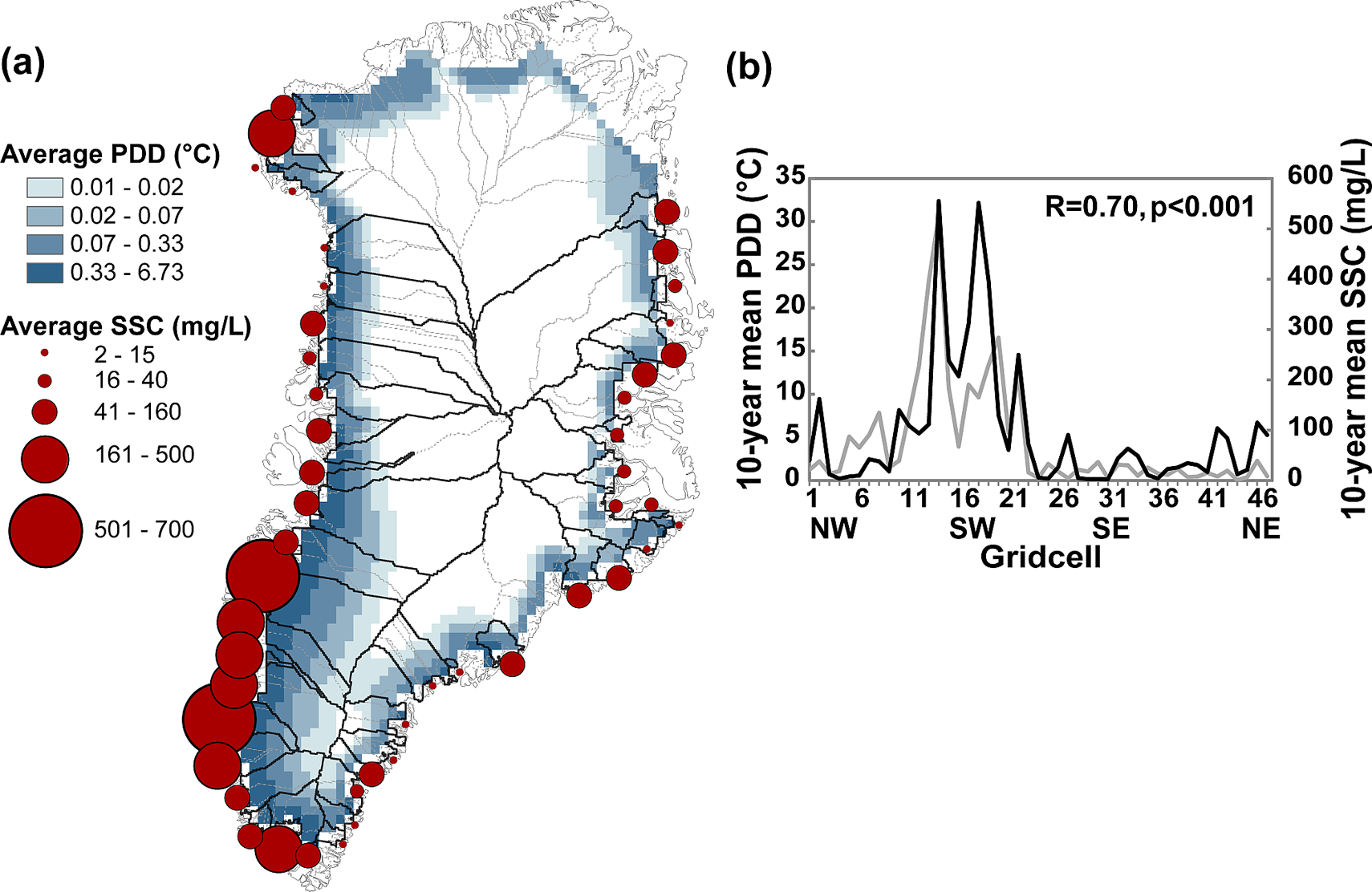
(a) Map of 10-year mean ice sheet meltwater production for 2000–2009 as represented by positive degree days (PDD) and fjord plume suspended sediment concentration (SSC, circles) for drainage basins with available data. (b) Spatial variation of 10-year mean PDD (gray line) and SSC (black line), starting in the northwest and going counterclockwise towards the northeast.
2 Ocean warming effect on tidewater glaciers
While basal lubrication from enhanced meltwater input is the dominant mechanism for increased velocities on land-terminating glaciers and some marine-terminating glaciers, calving effects and the interactions with the ocean may be more of a driving force for marine-terminating outlet glaciers with an extensive floating tongue. Floating tongues and ice shelves provide a buttressing back-stress transmitted to the upstream ice flow from drag exerted by lateral walls, slower-flowing ice, and basal resistance on grounded spots (Cuffey and Paterson, 2010). Floating tongue breakup can reduce the buttressing effect and propagate force perturbations up-glacier that are sustained by thinning (Howat et al., 2005; Thomas, 2004).
The fjord of Jakobshavn Isbrae has been shown to exert great control over the outlet glacier’s calving and velocity. Calving and ice discharge on the outlet glacier has experienced rapid increases, particularly from a change in flow dynamics around 1998 after half a century of terminus stability (Sohn et al., 1998; van der Veen et al., 2011) with velocity increases of 30% during that time (Thomas, 2004). The loss of a substantial portion of the floating tongue can decrease the buttressing effect and trigger these anomalous speed increases due to a reduced amount of back-force (Joughin et al., 2004; Thomas, 2004; Thomas et al., 2003), with similar observations in Helheim Glacier (Howat et al., 2005) and smaller southeastern glaciers (Howat et al., 2008). Collapse of the floating tongue and over 10 km of retreat during 1997–2001 have been observed (Csatho et al., 2008), suggesting that the lower parts of the glacier respond to local surface summer melting as well as breakup of sea ice and icebergs (Sohn et al., 1998). However, decreased back-stress from floating tongue loss is not the only control on calving rates, and van der Veen et al. (2011) hypothesized that weakening ice or change in bed properties could have caused velocity shifts in Jakobshavn Isbrae. Another large calving event in 2010 that caused 25% of the floating tongue of Petermann Glacier in northwest Greenland to break off illustrates similar circumstances, but there was no corresponding glacier speedup, suggesting that for some of these glaciers melt-enhanced basal lubrication may still be a prominent driver of dynamic changes (Nick et al., 2012).
The most direct indicator of ocean influence is the thinning and glacier acceleration associated with ocean temperature and circulation. Thinning occurs both at the surface from warm air temperatures as well as along the bottom of their submerged faces from warm ocean waters (Holland et al., 2008; Motyka et al., 2011). Ocean warming and inflow of subtropical waters is shown to be related to periods of glacier retreat (Christoffersen et al., 2011; Straneo et al., 2010; Walsh et al., 2012). Walsh et al. (2012) measured thinning, retreat, and velocity of central eastern Greenland marine-terminating glaciers, finding a synchronicity in changes and a distinct difference between glacier retreat north and south of 69°N latitude, which corresponds to the northern limit of transported subtropical waters. The greater velocities and rates of thinning for glaciers south of 69°N interacting with warmer ocean waters indicate that coastal heat transport is a primary driver of marine-terminating glacier changes (Straneo et al., 2010; Walsh et al., 2012).
Bottom melting is a very significant mechanism for mass loss, both from direct melting and from deep incisions forming bottom channels in the ice, affecting grounding-line stability of the floating tongue (Rignot and Steffen, 2008). Submarine melting rates have been measured to be two orders of magnitude larger than surface melt rates, but comparable to rates of iceberg discharge (Rignot et al., 2010). This large control that sea surface temperature and ocean circulation have on dynamic changes in outlet glaciers suggests that in future warming scenarios with warmer oceans, glacier thinning and retreat may become enhanced. Furthermore, decreasing sea ice extent, which can increase ocean heating, is a possible driver for enhanced GrIS melting through onshore advection of the warmer air (Rennermalm et al., 2009).
VIII Conclusion
The most pressing limitation in predicting GrIS contributions to sea level rise is the uncertainty arising from the effect of increased meltwater input into englacial and subglacial environments and subsequent response of ice velocities. The understanding of GrIS hydrology presented here is mainly inferred from alpine and Arctic glaciers, with the assumption that the processes will scale up to the ice sheet. Numerous studies refer to rapid uplift and increased glacier velocities from changes in meltwater input as an analogue of GrIS outlet glacier dynamic response to increasing meltwater (Bartholomew et al., 2010; Colgan et al., 2011a; Sundal et al., 2011). While peak ice flow velocities are higher in high-melt years than in low-melt years, annual velocities may be unrelated to annual surface melt due to englacial and subglacial drainage organization development throughout the melt season, which increases efficiency of meltwater transport and dispersal. Both processes, melt-induced acceleration through basal lubrication and velocity slow-down with evolution of englacial and subglacial efficiency, occur simultaneously over a melting season. It is an open question as to whether one process will dominate over the other in the future, and whether increased melting can change these mechanisms.
Reliance on surface observations and theoretical models makes it difficult to study englacial and subglacial environments. While englacial and subglacial conduit network development most likely varies spatially, inferences from surface meltwater production and ice movement are not sophisticated enough to establish the exact nature of englacial and subglacial hydrology. Temporal and spatial development of these internal networks remains poorly understood and yet is a key factor in determining annual glacier velocity cycles. This linkage between surface melting and ice dynamics is the most compelling knowledge gap in the pursuit of understanding future GrIS contributions to sea level rise, yet all components of the GrIS hydrologic system influence this mechanism and require a better understanding.
A string of extreme melt events between 2007 and 2012 brings to the forefront questions of how albedo changes will affect melting, and how this increased meltwater translates into either increased water retention through refreezing and storage or increased runoff. The positive feedback between increasing melt and decreasing albedo can be enhanced by earlier melt onset exposing bare ice prematurely, meltwater pooling into supraglacial lakes, and the presence of dust on the ice surface. This dust is typically exposed through the melting of outcropping ice, but an important unknown is the contribution from enhanced dry or wet deposition of wind-blown dust to albedo feedbacks.
With surface meltwater able to penetrate cold firn before refreezing or migrating down-glacier, partitioning meltwater into runoff becomes a key problem. While there is a general understanding that refreezing occurs at higher elevations and runoff forms at lower elevations, the processes of meltwater percolation, refreezing, and firn densification are not well parameterized. Furthermore, meltwater retention and movement at depth show that runoff initiation is controlled by at least the upper 10 m of the firn layer rather than just surface conditions (Humphrey et al., 2012), limiting the capability of near-surface remote sensing to identify runoff initiation. Better models of firn densification and meltwater retention are needed to aid remotely sensed studies of runoff formation, though this will require more in situ process studies of these phenomena. Models lacking accurate treatments of these processes may lead to an overestimation of sea level rise.
As knowledge of hydrologic processes becomes more integrated with ice dynamics, the importance of supraglacial meltwater transport and drainage through streams, lakes, moulins, and crevasses has become heightened. In particular, the question of the importance of supraglacial lakes compared to moulins and crevasses in delivering water to the englacial and subglacial environments needs to be quantified and understood. While fast supraglacial lake drainages can provide meltwater directly to the bed to locally influence ice dynamics, they cannot account for spatially extensive dynamic changes in mass loss and glacier velocity. Field investigations have been limited to the western GrIS and may not be representative for the entire GrIS. Therefore, models need to incorporate the spatial diversity that drives hydrologic and ice dynamic responses regionally. Studies are only beginning to address the spatial and temporal influx of meltwater into the ice sheet through moulins and crevasses aided by the increasing availability of high-resolution satellite imagery.
In contrast to the strong body of research focusing on supraglacial lakes, there is very little unique work about GrIS supraglacial streams, moulins, and crevasses, and knowledge about their morphology is primarily inferred from research on glaciers. This lack of attention is mostly owing to inadequate spatial resolutions of commonly available satellite imagery for capturing their small size and logistical difficulties in fieldwork. However, the over-emphasis on supraglacial lake drainages as a key factor in rapidly injecting large volumes of meltwater to the bed has been detrimental to understanding how meltwater leaves the GrIS surface. The few studies of GrIS supraglacial hydrologic features show that moulins provide rapid drainage of large upstream areas into englacial and subglacial systems, while crevasses provide a slower, more spatially distributed drainage. In contrast to the intermittent meltwater supply from lake drainages into moulins, supraglacial streams provide a steady supply of large volumes of meltwater into moulins during the melt season, leaving them as some of the most important and unstudied features for understanding hydrologic inputs to the ice sheet and to the ocean. Advancing techniques in mapping supraglacial stream networks will aid in assessing stream morphology, channel efficiency, and melt-water flux. The lack of understanding of the proportion of meltwater produced at the surface that moves into channelized streams and rivers to drain into the ice sheet through fractures and moulins hinders more accurate assessments of future ice sheet response to warmer temperatures.
Proglacial environments provide a great opportunity for assessing true meltwater flux into the ocean through river discharge. Monitoring proglacial river discharge in Greenland is one of the few ways to quantify meltwater flux from land-terminating outlet glaciers, and the handful of existing river discharge data sets have provided evidence for meltwater retention, jökulhlaups, and subglacial drainage organization. However, these observations are rare because of logistic challenges and inaccessibility of most proglacial rivers. Moving forward requires development of remote sensing techniques for quantifying discharge, with studies in other areas showing that remotely measuring width in braided rivers can be used to retrieve discharge, given knowledge of hydraulic geometry relationships and parameters (e.g. Ashmore and Sauks, 2006; Smith et al., 1996).
Buoyant sediment plumes remain a viable yet largely unexplored tool for assessing meltwater export at large spatial scales due to their presence around the ice sheet in fjords draining both land- and marine-terminating glaciers. Visible in remote sensing imagery, their seasonal presence broadly correlates with surface melting around the GrIS, with higher melt regions producing plumes with higher sediment concentrations that persist longer in the fjords. The main limitation in linking plumes to surface melt lies in the different controls of sediment output from different outlet glacier types. Fast-flowing marine-terminating glacier outlets are more challenging for plume observations due to calved icebergs obstructing detection and the dependence on subglacial discharge rising hundreds of meters to form buoyant plumes. While remote sensing of proglacial river discharge and fjord sediment plumes is still in its infancy, advancements in assessing these two components comprising meltwater runoff would greatly improve understanding of the GrIS’s future contributions to sea level rise.
Increasingly, available remote sensing technologies and interest in GrIS hydrologic components have improved understanding of ice sheet response to future warming scenarios. Transformative studies have come out of data from satellites launched during the 2000s, with GRACE providing independent estimates of mass loss and MODIS offering high-temporal resolution for tracking supraglacial lake dynamics, for example. Remote sensing is the most reasonable technique for merging small-scale in situ observations with coarser-scale models because of greater spatiotemporal coverage from satellite imagery. However, difficulties lie in obtaining spatially extensive in situ observations and particularly in integrating small-scale field studies with coarse large-scale model outputs. Site-specific field studies on the GrIS are rare in comparison to measurements from small Arctic or alpine glaciers due to the logistical difficulties in working on the ice sheet (and even proglacially), even with a number of field research sites offering science support. Despite these limitations, an intense interest shown by the scientific community to understand GrIS vulnerabilities in future warming scenarios, particularly with hydrologic implications, provides great opportunities for overcoming these challenges.
Footnotes
Funding
This work was supported by the NASA Cryospheric Sciences Program grant NNG05GN89G, managed by Thomas Wagner.
Acknowledgments
I greatly appreciate the thoughtful and constructive reviews from A. K. Rennermalm and an anonymous referee, detailed proofreading from C. J. Gleason, and helpful comments from L. C. Smith, all of which have led to substantial improvements of this paper. I also thank M. Zebrowski for his graphic art assistance on Figure 1, and to N. Selmes, A. G. Fountain, and J. S. Walder for use of Figures 4 and ![]() .
.