
Abstract
Among the more complex and devastating interactions between climate and hydromorphological processes in mountain environments are landslide lake outburst floods (LLOFs), resulting from mass movements temporarily blocking a drainage system. This work reviews these processes in the Himalayas and highlights the high frequency of this type of phenomenon in the region. In addition, we analyse two recent catastrophic trans-national LLOFs occurring in the Sutlej river basin during 2000 and 2005. Based on high resolution satellite images, Tropical Rainfall Measuring Mission (TRMM), Moderate-Resolution Imaging Spectroradiometer (MODIS) derived evolution of snowline elevation and discharge data we reconstruct the timing and hydrometeorological conditions related to the formation and failure of landslide dams. Results showed that the 2005 flood, originating from the outburst of the Parchu Lake, was not related to heavy precipitation, but was likely enhanced by the rapid and late snowmelt of an unusually deep and widespread snowpack. The flood in 2000 was triggered by the outburst of an unnamed lake located on the Tibetan plateau, identified here for the first time. In this case, the outburst followed intense precipitation in the lake watershed, which raised the level of the lake and thus caused the breaching of the dam. As stream gauges were damaged during the events detailed discharge data is not available, but we estimated the peak discharges ranging between 1100 m3 s−1 and 2000 m3 s−1 in 2005, and 1024 m3 s−1 and 1800 m3 s−1 in 2000. These events caused significant geomorphic changes along the river valleys, with observed changes in channel width exceeding 200 m. Results also demonstrate that remotely-sensed data enables valuable large-scale monitoring of lake development and related hydrometeorological conditions, and may thereby inform early warning strategies, and provide a basis for flood risk reduction measures that focus on disaster preparedness and response strategies.
I Introduction
Flood and landslide disasters are common in the Himalayan region, owing to the unfavourable interaction of climate, topography and seismicity (Nadim et al., 2006). This natural predisposition is exacerbated by anthropogenic processes, including land use changes, urbanization, and population growth within landslide affected areas (Petley, 2010). However, hydrogeomorphic processes and related disasters in the Himalayan mountain system are relatively poorly known compared with many other physical environments (Worni et al., 2012, 2013). This is in part due to their inaccessibility, their topographic, climatic and geomorphic complexity, and general lack of long-term monitoring activities (Shroder and Bishop, 1998).
Among the more complex and devastating interactions between climate and geomorphic processes in such mountain environments are catastrophic landslide lake outburst floods (LLOFs), resulting from landslides or other mass movements (e.g. rock falls) temporarily blocking or damming a river valley (Hewitt, 2006a; Jakob et al., 2016). These dams can form lakes which can breach at timescales varying from days to years after their formation (Li et al., 1986), producing some of the largest known catastrophic floods (O’Connor et al., 2013). The resulting dam geometry and the hydrogeomorphic characteristics of the upstream catchment area are primary factors determining the stability and longevity of landslide dammed lakes, with some lakes becoming permanent new landscape features (Korup, 2004). However, landslide dams may threaten locations at significant distances up- or downstream of the original emplacement site. Such off-site impacts include backwater ponding, catastrophic outburst floods and debris flows, draw-down induced secondary landslides, or reservoir displacement waves (Schuster, 2000). The propagation of these impacts is associated with long-term effects of channel instability, avulsions, and river metamorphosis due to overloading with landslide-derived sediment (Korup, 2005).
Most parts of the region between the main Himalayan range and the Tibetan Plateau are not very densely populated. However, the high connectivity between hillslopes and river channels introduces the potential for impact translation within the drainage network. Therefore, even if landslides occur in remote areas, the subsequent flood-related impacts are transferred very long distances downstream, and potentially become transnational events. Moreover, with development attracting more people and bringing increasing wealth and infrastructure into exposed downstream regions, the LLOF risk is likely to increase in the Himalayas (Schwanghart et al., 2016b). However, LLOF risk assessment is hampered by difficulties in slope stability analyses, and lack of information about the occurrence and triggering mechanism of past landslides and related lake formation and failure (Hewitt, 2006a).
The aim of this work is to provide a first comprehensive review of LLOF studies both in the broader Hindu Kush–Karakoram–Himalayan (HKH) region and more specifically at our study site, the Upper Sutlej River basin, so as to explore the frequency of this type of events in the past. We also focus specifically on two important trans-national LLOFs occurring in the Sino-Indian Sutlej river basin during 2000 and 2005. These events were analysed by Gupta and Sah (2008) who reported the first data and impacts of the floods in terms of economic damage. Here we extend their work by reconstructing the hydrometeorological conditions leading to the formation and failure of the landslide dams and by assessing some of the geomorphic imprints relating to these flood events. In addition we report here the source of the flood in 2000 (an unnamed lake), which was previously unidentified.
II LLOFs in the Hindu Kush–Karakoram–Himalayas
Numerous catastrophic outburst floods have occurred during the Holocene in many areas of the Tibet-Himalayan orogeny (Figure 1; Cenderelli and Wohl, 2003; Hewitt, 1988, 1998; Richardson and Reynolds, 2000; Shroder, 1998; Shroder et al., 1993; Vuichard and Zimmerman, 1986; Yamada, 1998). More recently, in the early 1980s, several catastrophic rock slope failures were recognised in the Karakoram (Hewitt, 1988) and in the Nanga Parbat range (Shroder et al., 1989). The works presented by Hewitt (1982, 1998) provided an extensive record of natural river damming in the Karakoram region, with thirty-five outburst floods recorded in the past two hundred years. Among the earliest studies reporting mass movements in the HKH region, many of them damming valleys, are those by Costa and Schuster (1987, 1991) and Shroder and Bishop (1998). Costa and Schuster (1987) were also the first to classify the type of dams and fans formed after landslides. Throughout the 1990s, surveys pointed to the existence of more than 200 landslides in the Upper Indus basin (Hewitt, 2002b). In a subsequent study, Hewitt (2006b) described 161 mass movements damming rivers in the Indus River Basin and defined the concept of ‘naturally fragmented rivers’. Over the last decade, many other studies reported LLOFs in the HKH region (Dunning et al., 2007; Mitchell et al., 2001; 2007; Petley, 2010; 2011; Sangode et al., 2011; Schneider et al., 2013; Seong et al., 2008; Walsh et al., 2012; Weidinger et al., 2002), highlighting the importance of this type of cascading process in the region.

(a) Catastrophic LLOFs in the Himalayan Range extracted from bibliography and (b) observed dams and the two LLOF analysed in this work in the Upper Sutlej River Basin.
The causes and triggers of landslides and dam formation vary significantly (Schneider et al., 2013) and in some cases are still widely debated (Hewitt, 2001). Weidinger (1998a), for instance, studied modern lake-damming landslides in the Birahi Ganga Valley and in western Nepal, and discussed the importance of tectonic, lithological, morphological, and climatic conditions for landslide triggering. Furthermore, their study highlighted the immediate and high risk of flooding downvalley in the event that landslide-produced dams were to break catastrophically. Paul et al. (2000) showed that most major landslides, which are completely or partially blocking the drainage, occur during the monsoon season in the Kali Ganga Valley of Kumaun Himalaya. Barnard et al. (2001, 2004a, 2004b) examined natural and human-induced landslides in a study area in the Garhwal Himalaya of northern India. Natural river damming landslides occurred in this region as a consequence of earthquakes and were controlled by the geological setting (i.e. foliation in metamorphic rocks). On the other hand, human activities have initiated and accelerated landsliding in this region primarily via the undercutting and removal of the toe of slopes for the cutting of roads and paths, thereby reducing slope cohesion and strength. Arnaud-Fasseta et al. (2005) showed the significant influence of land use changes and man-made structures during floods. They pointed out that the existence of protective structures such as river dikes or road embankments, may result in more sensitive (i.e. more vulnerable or with a potentially higher risk) torrential systems even during minor events. Although they illustrated these issues analysing a catastrophic flood in the French Alps, their results can be extrapolated to any other mountain region.
The geomorphic consequences of dam breaking are massive erosion, sediment transport, and the formation of flood terraces downvalley (Morche and Schmidt, 2012). The fluvial response might be marked enough to be recognised in the river profile for long time periods (Korup et al., 2006), possibly even over thousands of years (Hewitt et al., 2011). Prehistoric rockslide dams offer insights into such fluvial responses over a range of timescales through characteristic assemblages of hillslope, fluvial, and lacustrine landforms and sediments (Fort et al., 2009; Hewitt, 2002a; Pratt-Sitaula et al., 2004; Schwanghart et al., 2016a; Weidinger and Ibetsberger, 2000). In this case, landslide interruption of trunk streams is responsible for the segmented and terraced insets that formed during successive episodes of aggradation and trenching related to changes in the local base level (Cornwell et al., 2003; Shroder and Bishop, 1998).
More recent events, such as the 1893 Gohna Tal rockslide dam on the Birahi Ganga, a tributary of the Alaknanda River (Weidinger, 1998b), also exemplify the long-term response of historic events. Although overtopping and catastrophic failure occurred in 1894, forming four terraces on the flanks and downstream of the eroded dam, the lake did not empty completely. The remnant lake took 78 years to infill and although the river fully incised the dam, it has not yet cut down through the alluvial sediments and still meanders on top of the deposits before it enters the breach channel. High rates of infill were also estimated for the rockslide dams of Jagat (formed between 1962 and 1979) and Labubesi (1968) on the Buri Gandaki River, Manaslu-Kutsang-Ganesh Himal, Nepal. Both landslides formed ephemeral lakes which were infilled within 17 years (Jacobsen, 1990). Although the dams were subsequently dissected, both dam-breach channels have not yet fully cut through the aggraded material, thus forming 50-m high prominent steps in the longitudinal profile.
Therefore, the stability conditions (in terms of mechanical and dynamic properties) after dam formation are crucial in the assessment of the likelihood for the dam to fail and potentially trigger catastrophic flooding (Carrivick, 2010; O’Connor and Beebee, 2009). Weidinger (2006a, 2006b) distinguished different categories of landslide dams in the Indian and Nepal Himalayas and in China based on their shape, volume, and composition of the deposited landslide material, as well as in the size and life span of their formerly dammed lakes. Schneider (2009) rated dams according to the probability of failure. However, most of the research has so far been site-specific, and therefore partly reflects the difficulty of acquiring accurate or representative geomorphometric data of past events (Costa and Schuster, 1991; Korup, 2002, 2013).
In general terms, landslide dams may cause two different types of floods (Schuster and Evans, 2011): (i) upstream floods due to the backwater effect with flooding taking place as impoundment fills (e.g. Hunza disaster in Northern Pakistan) and (ii) downstream flooding resulting from dam failure. In this work, we focus on the latter type of events, and analyse two landslide-dammed lakes that triggered catastrophic floods downstream due to the breaching of their dams.
III Study site
The upper Sutlej River Basin (alternatively called Satlej or Satluj) is the easternmost tributary of the Indus River. The entire Sutlej River basin is transboundary. It has its source and headwaters in Tibet, in the Kailash mountain range (Western Tibet), then flows west to enter India in the state of Himachal Pradesh, from where it later crosses into Pakistan. The Sutlej River is 1536 km long and has a catchment area of 75,369 km2 (NDMA-UNDP, 2010). In this study, we focus on the upper section of the Sutlej River upstream of Bhakra dam and close to the city of Nangal in Himachal Pradesh (Figure 1). The Upper Sutlej River, i.e. the basin area investigated here, has a drainage surface of 47,970 km2, with more than 40% located within Tibet. Elevation ranges between 5786 m a.s.l. and 927 m a.s.l., and the total length of the main river channel is 460 km. The two main tributary rivers of the Sutlej River within the study area are the Spiti and Baspa Rivers.
The high arid landscapes of the study area are typically covered by a thin layer of regolith which only supports sparse grasses and small shrubs (Bhattacharyya, 1989). The region contains deeply incised valleys, exhibits extreme relief (with local relief typically in the order of 1000–2000 m), extensive glaciation, and ubiquitous mass movements. Geologically, the study area comprises thick successions of medium to high-grade metamorphic rocks and their sedimentary cover. The succession is emplaced by granite intrusions of varying ages. The sedimentary succession is represented by fluvio-lacustrine deposits of laminated clays, silty clays and horizontally bedded sands (Joshi, 2010). The presence of lacustrine deposits also suggests that neotectonic movements along the numerous faults were responsible for blocking the river basin, ensuing landslides and forming lakes. Especially, active paraglacial processes and postglacial rock debuttressing have induced landslides, with outburst floods occurring at lower altitudes within this zone. Rates of denudation are thought to be high in this region given the extensive relief. Erosion surfaces, more aptly termed ‘relict landscapes’, represent remnants of fluvially sculpted and sometimes glacially modified surfaces. Active river incision and uplift produced fluvial-fill and fluvial-incision (strath) terraces (JoshiOwen, 1989).
The steep and unstable valley sides, including bedrock and glacial deposits, provide large volumes of sediment that is reworked by streams and debris flows to form active alluvial fans. Large alluvial fans are common where tributaries enter the main valley; they also conjugate to form series of coalescing alluvial fans (or bajadas) at some sites. Most sediment fans are terraced due to trenching by floods or debris flows. The alluvial fans deposited by debris flows are generally composed of boulder to pebble material, typically steep (5–10°) and radiate from narrow valleys (Hewitt et al., 2011).
In climatological terms, the area has been divided into three zones, namely, a semi-arid to arid temperate zone (dry zone), a sub-humid to humid temperate zone, and a humid zone (wet zone; Gupta et al., 1993). The ranges of the Greater Himalayan range restrict most summer monsoon circulation from reaching the study area (Bookhagen et al., 2005). In spite of this, the monsoon dominates regional moisture transport and precipitation (Brown et al., 2003; Gasse et al., 1996). Average annual precipitation is 200 mm in the semi-arid to arid temperate zone, 200–800 mm in the sub-humid to humid temperate zone and 800 mm in the wet zone. In addition, the region is affected, at various temporal and spatial scales, by the mid-latitude westerlies, the Indian (or South Asian) monsoon, the East Asian monsoon, the El Niño Southern Oscillation (ENSO) and North Atlantic Oscillation (NAO), the Arctic Oscillation (AO) and local weather systems (Cuo et al., 2014; Hudson and Quade, 2013; Yao et al., 2013).
The fluvial regime of the Sutlej River is characterized by large diurnal and seasonal variations in discharge relating to glacier meltwater, although rivers are well fed during the summer by both glacier meltwater and monsoonal rainfalls. In the monsoon dominated portions of the basin, precipitation mainly occurs between May and October, whereas in the areas dominated by the westerlies, the seasonal pattern of precipitation varies showing two peaks in spring and summer, respectively. As a result, streamflow is concentrated during May–October and peaks in July–August (Guan and Chen, 1980).
1 LLOFs in the upper Sutlej River Basin
Many LLOFs during the Quaternary period have been identified in the Sutlej River valley and its tributaries (Chauhan et al., 2014; Dortch et al., 2009; Gupta and Sah, 2008). Active and palaeolandslides observed in the area indicate that mass-movement activity and associated outburst and flash floods are common in the Sutlej catchment (Figure 2) and that they have operated since geological times. These processes are directly related to the disposition of Quaternary deposits in the form of lacustrine sediments, alluvial terraces, debris fans, and different morphological zones observed in the area.

Examples of LLOF evidence in the Upper Sutlej River Basin: (a) alluvial fan with recent debris-flow deposits and rock slide/avalanche occurred in 1997 (Pabbar River hillslopes); (b) debris flow fan deposit, with dam likely formed between 2010 and 2012 (Pin River basin); (c) ancient alluvial fans in Spiti River valley located close to Kaza. Images are from Google Earth 2014. Dam types referred to the geomorphic classification by Costa and Schuster (1987).
Figure 2 shows examples of river damming events in the Pabbar, Pin, and Spiti Rivers. According to the classification proposed by Costa and Schuster (1987), most of the river dams are types I, II, III and V (i.e. tributary valley source and main valley source with upvalley and downvalley lobes with a T shape). For the most recent decades, documentary evidence provides a record of several major LLOF events in the region (Table 1). At least nine events in the Sutlej River basin occurred since 1973, and these events occurred both as a result of seismic and from aseismic triggering. In the following we will focus our analyses on the recent, devastating and trans-national events of 2000 and 2005.
Reported recent LLOFs in the upper Sutlej River Basin between 1973 and 2010. Some more details are described in Sharma (2006a, b). In grey the two events analysed in detail in this work.
IV Material and methods used to reconstruct the 2000 and 2005 LLOF events
Satellite imagery, available DEM data and other remotely-sensed products were combined to overcome the lack of ground-based monitoring of landslide dam formation and failure processes in the study region. Remote sensing using multi-temporal satellite images enabled us to analyse LLOFs by comparing images from before and after the events. Available high-resolution Google Earth imagery from the past decade was analysed, and in those cases where Google Earth imagery was not available, or of poor quality (e.g. snow or cloud covered) for the study sites and/or specific years (i.e. the years before the LLOFs) we used Landsat images. Landsat images at 30 m resolution extend back until the early 1980s with images taken every 16 days, while the higher resolution Google Earth imagery (available for a few dates only) provide additional information for the most recent period (since about 2000).
In the absence of local ground-based measurements, the reconstruction of precipitation during the months leading up to the breaching of the landslide dammed lakes in 2000 and 2005 is based on data from the Tropical Rainfall Measuring Mission (TRMM), using version 7 of the daily precipitation rates (3B42 v7 derived). In both case studies, data is extracted and averaged across all 0.25° (∼25 km) grid cells within the watershed area of each landslide dammed lake. Although it should not be considered a substitute for actual station data, TRMM 3B42 is a valuable source of information in view of the lack or scarcity of ground-based rainfall measurements, and has been used previously for Himalayan flood and landslide analyses (Allen et al., 2015; Durga Rao et al., 2014; Martha et al., 2015; Mathew et al., 2014).
To reconstruct and quantify changes in snow cover and thereby the possible role of snowmelt preceding the landslide lake outburst floods, Moderate-Resolution Imaging Spectroradiometer (MODIS) derived snow cover data was extracted for the lake watershed areas. We used the MODIS/Terra Snow Cover 8-Day product (MOD10A2, algorithm version 5, 500 m resolution) which provides a large-scale snow cover record extending from 2000–2014. Methods described in Allen et al. (2015) are followed to reconstruct the mean snowline elevation within each lake watershed over a 4-month period starting 30 March.
Available discharge data from three stream gauges installed along the Sutlej River were provided by the Indian Institute of Hydrology and used to analyse the magnitude of the events. Daily discharge data are from Khab (data for the period 1976–2005), Kasol (1964–2013) and Rampur (1963–2014; Table 2). The upper-most stream gauge, located in Khab, was of limited use as it was damaged during both the 2000 and 2005 flood events. In addition, some inconsistences appeared in the data when compared with values provided by Gupta and Sah (2008). The peak discharge of these two events was therefore reconstructed by correlating records of the other two stations located downstream (Kasol and Rampur). However, this approach and the insufficient temporal resolution (i.e. daily) of discharge data provided much lower values than has been previously reported, and therefore, the exact magnitude of the events remains uncertain. We analysed all sources and provide here a comprehensive summary.
Summary of the three stream gauges installed along the Sutlej and used in this study.
*To the confluence of Parchu and Sutlej rivers.
**Except year 2000.
For the two events we made a flood frequency analysis (FFA) based on available annual maximum discharge at Khab station, using a Bayesian Markov Chain Monte Carlo (MCMC) procedure (Reis and Stedinger, 2005). This approach can handle information from instrumental observations in a straightforward way through adequately defined likelihood functions and, more importantly, can account for uncertainties in hydrologic extremes as it provides estimates of confidence bounds for the estimated quantiles (Gaál et al., 2010). We used the code based on the nsRFA package (non-supervised regional frequency analysis) of the R statistical software (Viglione, 2009) which was specifically developed for FFA. An in-depth description of the method and the fitting procedure can be found in Gaál et al. (2010) and Gaume et al. (2010). In our case we are not adding historical information but the reconstructed discharge of the LLOFs to the systematic data series, in order to examine the effect that the inclusion of this data has on the FFA.
V Results and discussion
1 Dam formation and failure
Parchu Lake (32°19′36.13′′N; 78°43′10.42′′E; also called Parechu, Paree Chu or Parachu) formed on the Tibetan Plateau, in the Parchu River basin (Zhagong Wopuda) which is a tributary of the Spiti River. The Spiti valley is a desert mountain valley located at high altitudes in the Himalayan Mountains, in the north-eastern part of the Indian state of Himachal Pradesh, and is a tributary of the Sutlej River.
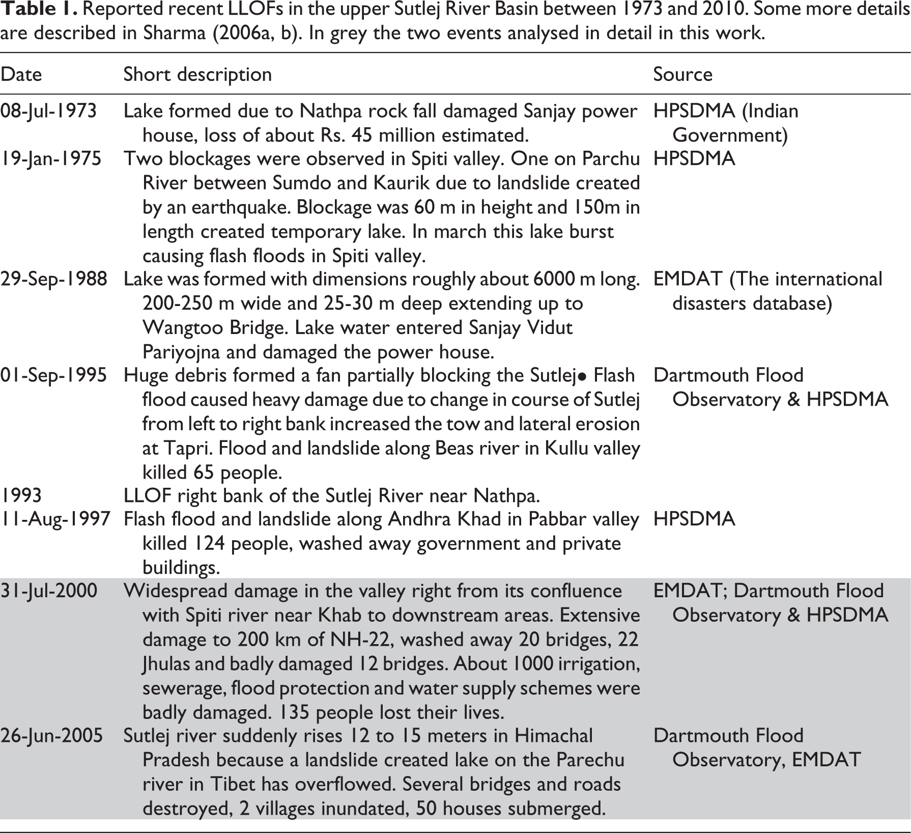
Based on satellite image interpretation, the formation of the landslide dam first becomes evident between 13 and 29 June 2004. The resulting dust and deposit from the slope failure, and already significant lake formation is seen clearly in a Landsat image taken on July 15 of the same year (Figure 3).
Series of Landsat images showing the formation of the landslide dam and filling of Parchu Lake (32°19′36.13′′N; 78°43′10.42′′E) in late April 2004 (a), and catastrophic failure of the dam and outburst flood in 2005, followed by subsequent enlargement of the lake again in June 2013. The landslide deposit which formed the dam is clearly evident as a lighter coloured deposit on 15 July 2004 (see arrow in b). Outflow from the lake is clearly visible on 2 July 2005, nearly 1 week after the catastrophic breaching of the dam (d). Over subsequent years the lake remained either empty or with a small volume of water accumulating (e). In June 2013 local authorities had renewed concern as the lake volume increased again to significant levels (f).
Distinctive horizontal margins on the sides of the lake basin provide evidence of previous lake levels within the basin. These former lake shorelines provide a clear reference against which the significant increase in lake water level during 2004 can be observed. Already in late July, 2004, India media reported overflow from the lake which caused flood alerts to be sounded, and hydropower projects were temporarily shut down due to the increased sediment load in the river. Some seepage and/or possible overtopping of the lake dam is evident when the lake appears at near full capacity in September 2004 (Figure 3(c)), but the lake level remains constant through until the following spring. Following the catastrophic failure of the dam on 26 June 2005, the first cloud-free satellite image is available nearly one week later on 2 July, by which time the lake level has dropped by approximately 30–40 m, the dam area appears to be completely eroded, and considerable outflow is visible downstream (Figure 3(d)). At the upstream end of the lake, sediments become increasingly visible as the lake water receded slowly over subsequent years, until only some remnant water remains pooled at the downstream end of the lake (Figure 3(e)). Local authorities became concerned when rising water levels were observed in the lake again in late June 2013, although outflow from the lake at this time appeared to be unobstructed and the lake level never reached the levels seen in 2004/05 (Figure 3(f)).
The exact source of the flash flood that damaged villages along the Sutlej valley in the Indian district of Kinnaur in July 2000 was previously unknown, although landslide damming and subsequent breaching of a lake somewhere in the Tibetan headwaters of the Sutlej River was suspected (Gupta and Sah 2008). Based on satellite image interpretation, we have identified the source as an unnamed landslide dammed lake (31°36′56.61′′N; 79°29′49.99′′E) located approximately 100 km upstream from the Indo-China boarder (Figure 1). The distinctive light coloured landslide deposit which dammed the river first became evident between images taken June 1992 and late May 1993, with the lake rapidly filling over the subsequent months (Figure 4(a) to (c)). Large blocks still remaining from the landslide deposit are visible in Google Earth imagery. The landslide dammed lake persisted for several years, generally reaching maximum capacity in July–August of each year, following the onset of monsoon precipitation in the region (e.g. Figure 4(d)). At maximum capacity the lake extended upstream for ∼2.5 km, and had a total area of ∼0.5 km2. Estimated depths measured from profiles taken across the former lakebed in Google Earth (based on SRTM 90 m), range from 10–20 m, giving an estimated lake volume in the range of 5–10 million m3. At the beginning of June 2000, prior to any onset of seasonal rainfall, the lake is somewhat below full capacity (Figure 4(e)), and no seepage or overtopping of the dam is evident. Some overtopping and breaching of the dam may have initiated already at the end of June, followed by the complete failure of the dam towards the end of July. A Landsat image on 5 August 2000, 5 days after peak discharge was measured (see next section), shows the dam to have breached with considerable outflow evident (Figure 4(f)).
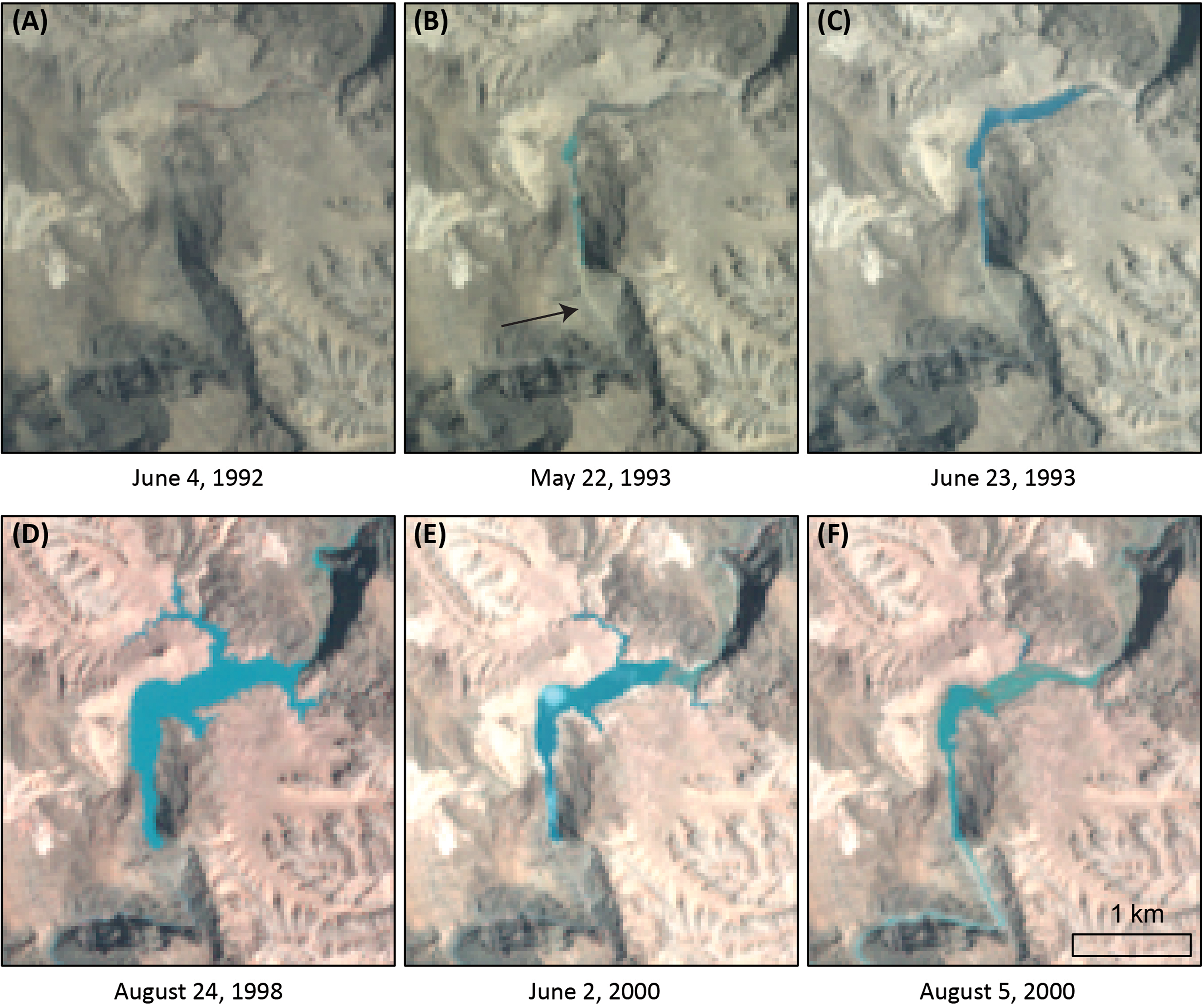
Series of Landsat images showing the formation of the landslide dam and unnamed lake (31°36′56.61′′N; 79°29′49.99′′E) between 1992 and 1993, and subsequent failure of the dam and outburst flood in 2000. The landslide deposit which formed the dam is first evident as a lighter coloured deposit on 22 May 1993 (see arrow in b). Over the subsequent years, the lake is seen to reach its largest size toward the end of each monsoon season (e.g. d), where some seepage also becomes occasionally evident below the dam area. On 2 June 2000, the lake appears somewhat smaller prior to the onset of seasonal rainfall (e), and subsequent failure of the dam area and outflow from the lake is clearly evident on 5 August 2000 (f).
2 Hydrometeorological conditions
Satellite imagery shows that Parchu Lake and its inflow and outflow channels were frozen during winter 2004/05. Significant and unusually high precipitation (∼128 mm) was recorded in the catchment area over the three-week period from 21 January through to 10 February 2005 (Figure 5). As a consequence of this heavy winter precipitation, snowline elevations remained around 700 m below average at the beginning of April, suggesting an unusually deep and widespread snowpack, with snowlines subsequently rising rapidly over the following weeks to reach more normal levels (at around 5000 m a.s.l.) by the end of April (Figure 6(a)). However, snowline elevations were approximately 200 m lower than average throughout May and June, suggesting an overall slower spring snowmelt during 2005, consistent with cooler spring temperatures across much of the Himalayan region (NCEP/NCAR reanalysis – http://www.esrl.noaa.gov/).

Tropical Rainfall Measurement Mission (TRMM) area averaged daily precipitation over the watershed area of Parchu Lake: (a) Daily measurements during 2005 and 2013 are compared to the longer-term (1998–2014) mean, maximum, and 90th percentile values. (b) Accumulated daily precipitation in 2005 is compared to the longer-term mean, and with daily stream discharge measurements at Khab during 2005. Also indicated is the accumulated daily precipitation during 2013.

MODIS derived evolution of snowline elevation within the watershed area of (a) Parchu Lake, and (b) the unnamed Tibetan lake. Values measured during (a) 2005 and (b) 2000 are compared to the longer-term range and mean values for the years 2000–2014.
Only modest precipitation amounts were recorded over the subsequent months, including 12 mm (25 and 26 June) immediately preceding the outburst flood (Figures 5 and 7(a)). Interestingly, the seasonal accumulation of precipitation through winter and into spring 2013 (i.e. at the time when the lake again reached threatening levels) followed a remarkably similar pattern as 2005, although spring 2013 was tail-ended by a significant precipitation event in mid-June (Figure 5(b)).
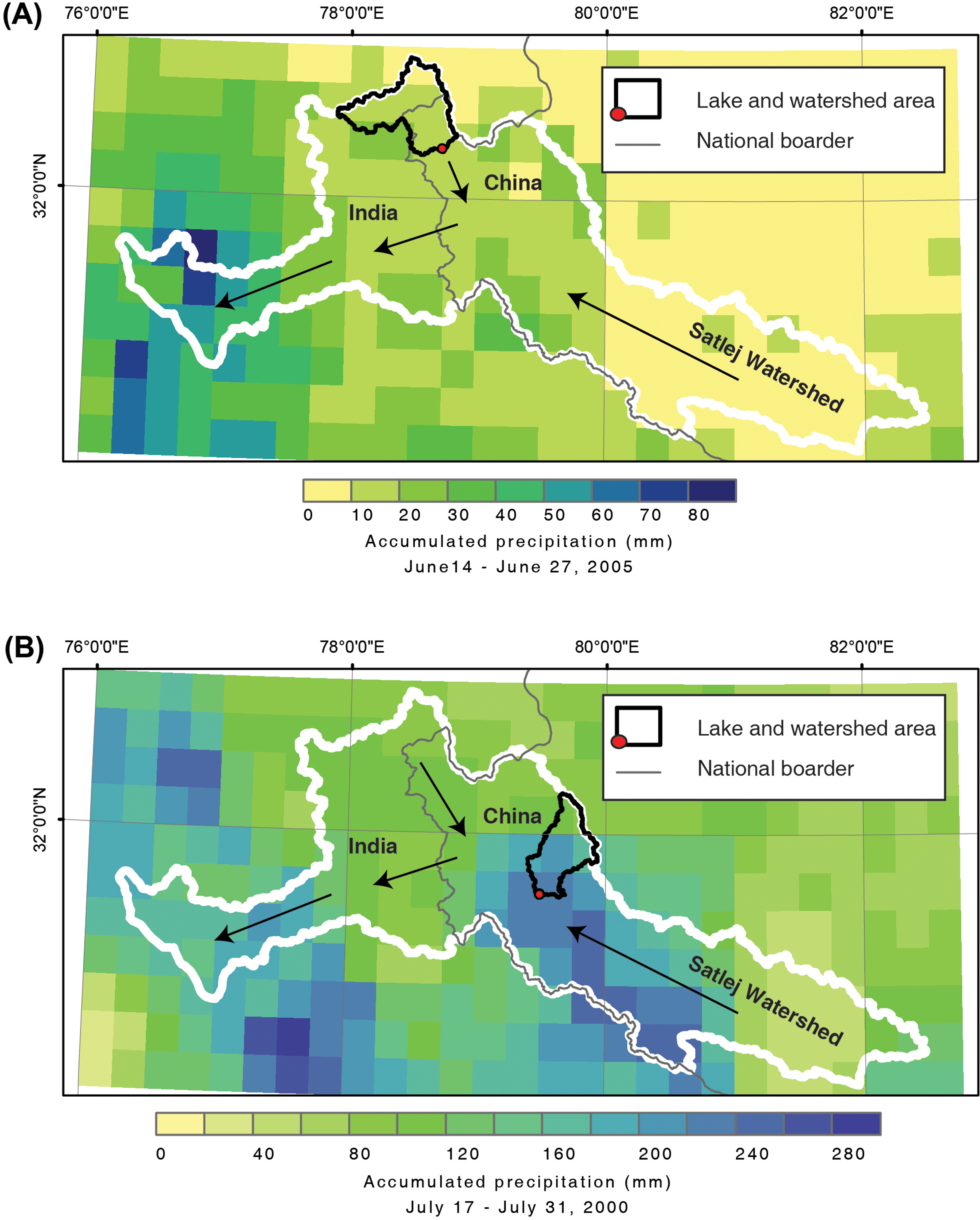
TRMM accumulated precipitation over the Sutlej basin (white outline) during the 2-week period leading to the LLOF from (a) Parchu Lake in 2005, and (b) the unnamed lake in 2000. Arrows indicate the main drainage direction within the Sutlej basin.
In the year 2000, precipitation during winter and spring had been about average (Figure 8), with snowline elevations mostly positioned higher than normal throughout April and June (Figure 6(b)). These observations are consistent with stream discharge on the Sutlej River being more or less normal at this time (Gupta and Sah, 2008). However, throughout June and July, the catchment area of the unnamed lake received sustained and occasionally very heavy precipitation, with 320 mm in total measured over these 2 months (compared to 144 mm as a longer-term average over the same period; Figure 8). Particularly in the latter half of July, rainfall intensities significantly increased, coinciding with the arrival of the monsoon front centred over the upper Sutlej basin (Figure 7(b)). The exponential increase in accumulated precipitation over the unnamed lake catchment broadly corresponds with the increase in Sutlej discharge measured during July 2000 (Figure 8(b)).

TRMM area averaged daily precipitation over the watershed area of the unnamed Tibetan lake: (a) Daily measurements during 2000 are compared to the longer-term (1998–2014) mean, maximum, and 90th percentile values. (b) Accumulated daily precipitation in 2000 is compared to the longer-term mean and with daily stream discharge measurements at Khab during 2000.
Analysis of the available discharge data shows inconsistent and incomplete values for the 2000 and 2005 flood events (Figure 9). However, we should reiterate that the most upstream station at Khab was damaged during both events and did not record the outburst floods properly. Our reconstruction based on the correlation with other stations resulted in a lower value equal of 731 m3 s−1 with an upper limit of 1100 m3 s−1 for the event in 2005, and a range between 676 m3 s−1 and 1024 m3 s−1 for the 2000 flood. These values are relatively low as compared to reported data and the values provided by Gupta and Sah (2008), with a maximum discharge close to 2000 m3 s−1 in 2005 and 1800 m3 s−1 in 2000 (plotted against our records in Figure 9).

Annual maxmum discharge series and 2000/2005 daily discharge recorded in the Sutlej River at Khab (a, b, c); Rampur (d, e, f) and Kasol (g, h, i). Data of peak discharges in 2000 and 2005 at Khab are based on reconstructions and data from Gupta and Sah (2008). Mean shows the mean value for the common period 1980-2000.
The discharge recorded at Rampur in 2005 was not significantly high, while at Kasol the flood in 2005 was the second highest after an earlier event recorded in 1964 (Figure 9(a), (d) and (g)). Inconsistencies between the two lower stream gauges suggest they might also have been damaged during the floods. In Rampur the maximum discharge recorded during the 2000 LLOF was the highest since 1963, although data shows a similar event in 1965. In Kasol, the highest value was recorded in 1965. Again these inconsistencies, together with the lack of sub-daily data, make it difficult to extract definitive conclusions about the exact magnitude of the 2000 event, but we assume that the range 1024–1800 m3 s−1 is the best estimation existing to date, accounting for all the uncertainties related to this type of extreme event.
Daily discharge data from 2005 reveals a notable increase starting already in early June, at all three downstream stations (Figure 9(c), (f) and (i)), despite the lack of any notable precipitation falling over this time (Figure 5). This strongly suggests that despite a relatively cold spring, snow and ice melt was the critical factor in raising water volume in Parchu Lake to catastrophic levels. The overall quantity of meltwater draining from the catchment area was likely larger than normal, owing to the significant precipitation events recorded during January and February.
The daily discharge measurements show greater fluctuations leading up to the 2000 LLOF event. As reported by Gupta and Sah (2008), average daily discharge at the beginning of June 2000 was 80 m3 s−1 (Figure 9), and after mid-June it started rising to reach maximum values of 126 m3 s−1 by the end of the month. In July a near-continuous increase in discharge was observed immediately before the peak LLOF event.
The FFA was applied to three constellations and with different types of data for the Sutlej River basin: (i) in-situ frequency analysis for the Khab data series (1977–2004) without the extreme LLOF events in 2000 and 2005, (ii) a frequency analysis adding the two events with estimated discharge ranges to the data series; and (iii) adding a threshold of 1100 m3 s−1 which was reached at least two times over the last 100 years as we report here (Figure 10).
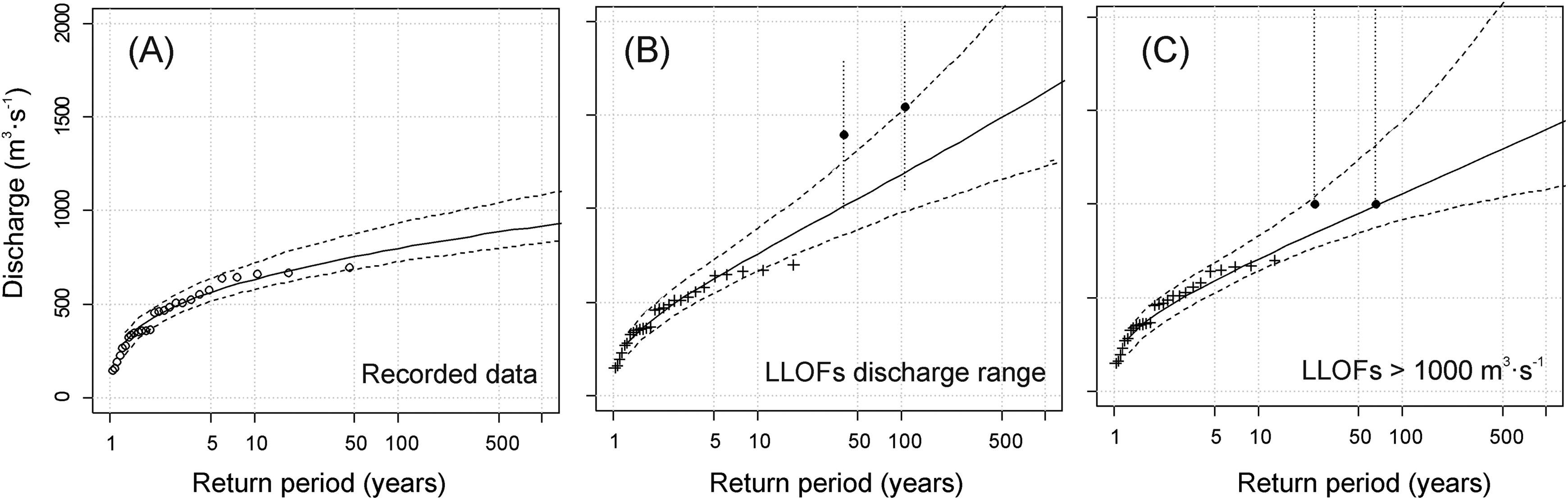
Fitted log-Pearson type III distributions of return periods of specific discharges based on the instrumental data at Khab (a) without the estimated discharge in 2000 and 2005; (b) adding the two events with the estimated ranges to the data series and (c) adding the threshold of 1100 m3 s−1 which was reached at least two times over the last 100 years.
The main observation extracted from the FFA analysis is that the quantiles for extreme events – usually used for flood risk assessments – increased significantly when the LLOFs events are included in the analysis. The 100-year flood increased from 724 to about 946 m3 s−1 (ranging between 914 m3 s−1 and 977 m3 s−1). This means that more extreme floods might be considered to happen more frequently, so the counter measures to reduce flood hazard and risk should be reconsidered. However, the frequency of the landslides that caused the floods might be very different from the frequency of a flood triggered by other factor (i.e. intense precipitation), and the frequency estimated by this method does not consider different triggers of floods. A catastrophic outburst flood can only occur if sufficiently large amounts of water have been retained behind a landslide dam in the first place. Furthermore, a dam failure mechanism (e.g. overtopping, displacement wave) must provide the opportunity for large water masses to escape in a relatively short time (Worni et al., 2013). Overtopping of the dam crest may occur during high-magnitude floods, and thus needs to be formulated as a function of flood frequency. By contrast, landslide-induced displacement waves are rather dependent on the probability of landsliding from the lateral slopes bounding the reservoir. Therefore, adding the recorded discharge data at the streamgauge to estimate flood frequency might result in unrealistic quantiles as floods are not necessarily caused by the same triggers. However, in order to asses potential LLOF hazard and risk the frequency of events is required. But the frequency (or probability) of such an event depends on the combination of the probability of a landslide event, the probability of a dam and lake formation given the landslide event and the probability of failure and of a landslide-dam and outburst (Korup, 2005).
3 Legacies of LLOFs in the upper Sutlej River basin
Even though we could not reconstruct the magnitude of the recent LLOF events in the Sutlej River basin with certainty, we easily observed the geomorphic imprint, especially for the event in 2005 for which high-resolution satellite imagery was available. As field work was out of the scope of this study, our geomorphic analysis had to rely on remotely-sensed data.
Figure 10 shows the significant geomorphic imprint that the 2005 LLOF left on the Parchu River (tributary of the Sutlej River), upstream of one of the most affected and heavily populated areas. The river widening was on average about 65 m in this reach, ranging locally between 50 and 150 m. Terraces and alluvial fans were completely eroded (such as T1 and T2, and the most downstream alluvial fan in Figure 11) and the flood deposited large amounts of (fine) sediment and boulders.
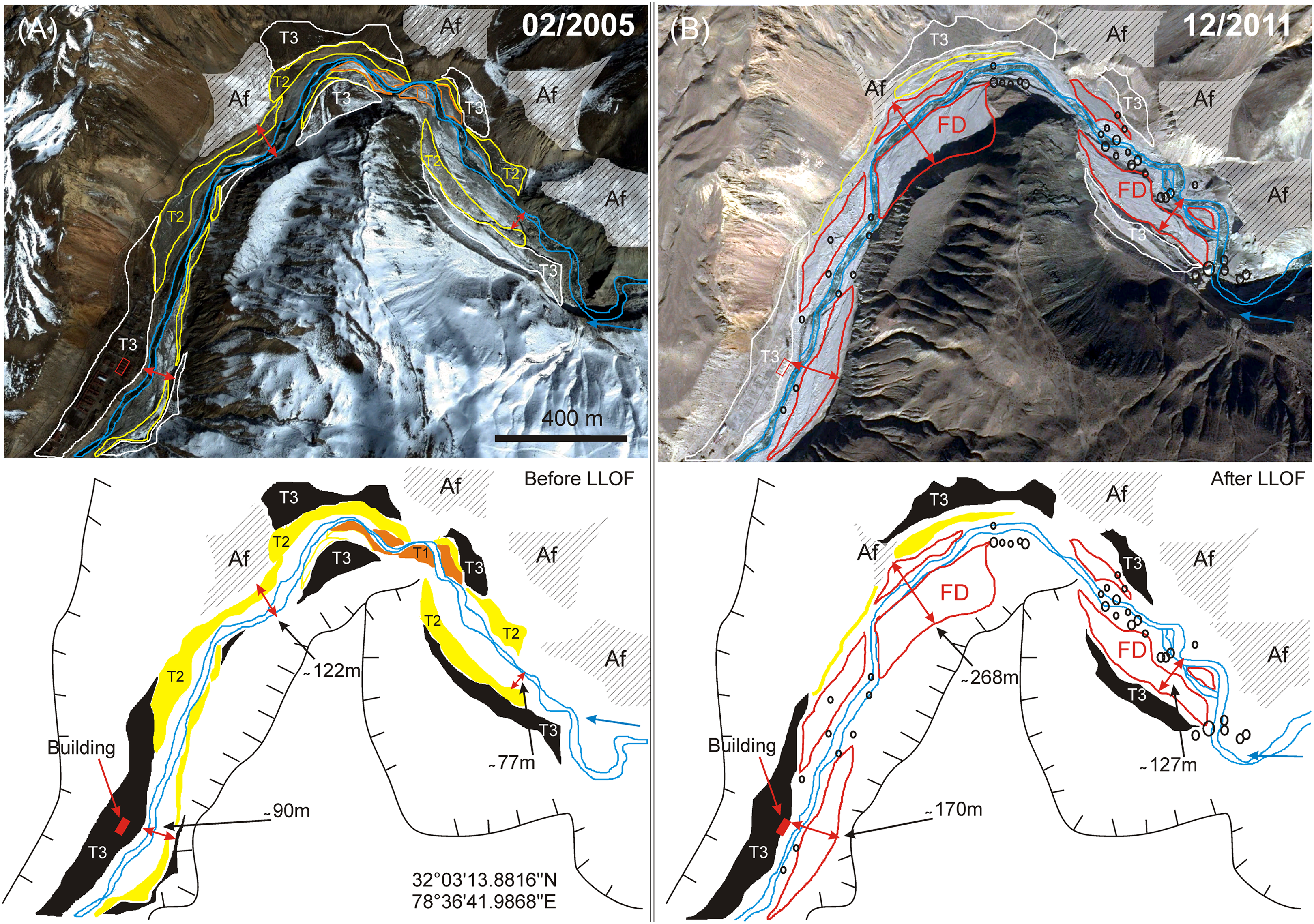
Geomorphic maps of the Parchu River upstream from its confluence with the Spiti River, close to Samdo village (a) in February 2005 (before the LLOF) and (b) in December 2011 (after the LLOF). T1, T2 and T3 are different levels of terraces; FD are flood deposits after the 2005 LLOF; small black circles are big boulders transported during the LLOF; red arrows indicate river widening during the LLOF and approximate values are shown; AF are alluvial fans; the blue line represents the low flow channel. Small red square shows a building in the most severely affected, populated area (there were several more). Images are from Google Earth.
Other affected areas were the reach upstream from the village of Chulusonggiecun, where three bridges were completely washed away, the main road damaged and river widening of up to 90 m eroded banks and terraces. The village of Gemupa was also significantly damaged, with many buildings, bridges and roads being totally destroyed. In this reach the river widened by about 90 m. In addition, landslides have been observed at Pawari and Shongtong as a result of toe erosion.
The analysis of satellite imagery also revealed that the valley floor morphology and, therefore, sediment transport and deposition processes in the Upper Sutlej River Basin, are strongly influenced by landslide dams, and this is not only true for the two cases analysed in this work. As observed in other regions (Whitehouse, 1983), we observed differences in channel morphology downstream and upstream of dams with lower river gradients above the deposit, along with marked aggradation, whereas incised streams and gorges occur below or at the level of the deposit. Connectivity between hillslopes and the river makes landslides and debris flows the main sediment sources to the river. Figure 12 shows, by way of example, how sediment dynamics may work as a result of river damming in the Spiti River.
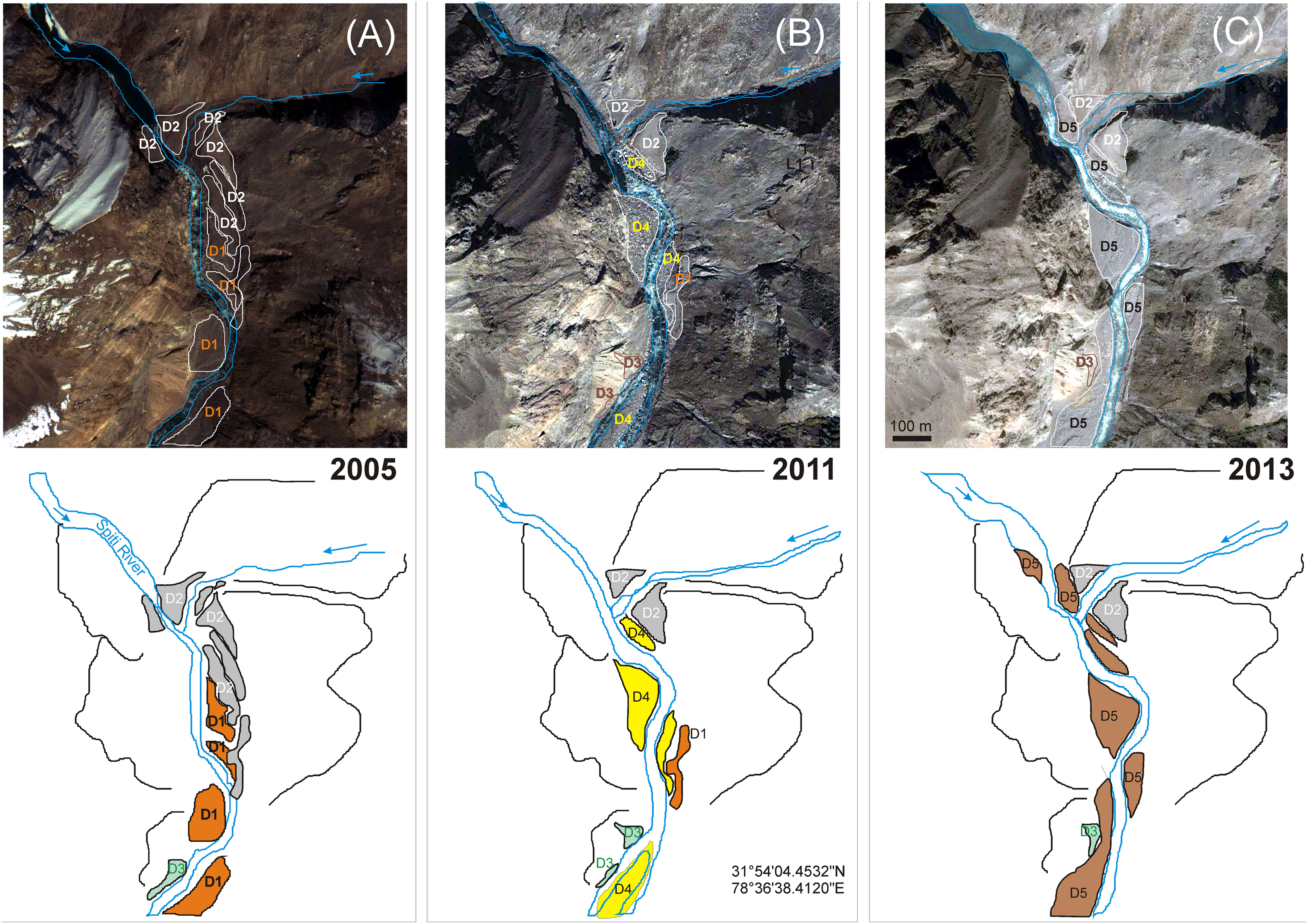
Small debris flow fan damming of the Spiti River close to Leo (downstream confluence with the Parchu River): (a) river damming prior to 2005 leaving deposits here referred to as D2; (b) between 2005 and 2011 when the river shifted and removed most of the D1 and D2 deposits but leaving new deposits (D4); (c) in 2013, most of the D4 sediment is eroded but sediment is supplied from upstream the tributaries such that the river aggradated between 2011 and 2013, forming a series of new bars (D5). Images are from Google Earth.
4 Implications for flood hazard and risk assessments
The stability of landslide dams, the possibility of catastrophic failure and subsequent outburst floods have received much attention in the past (Clague and Evans, 2000; Costa and Schuster, 1988; Schuster, 2000) and are obviously important for hazard and risk assessment in regions with considerable relief and significant landslide activity, such as HKH. Recent progress has been made in predicting where co-seismic landslide deposits may constrict and dam a fluvial system (e.g. Fan et al., 2014), but these approaches must be coupled in the future with comprehensive landslide susceptibility mapping that is generally lacking for remote areas of the HKH. In any case, most if not all upper catchments in the HKH are likely susceptible in some degree to the occurrence of landslides and subsequent dam formation. Therefore, local authorities may rather focus on rapid identification of new lakes, monitoring of persistent hazards, and subsequent early warning and risk reduction strategies in the event of a dam breach. In this regard, and despite that fact that several questions remain, lessons may be drawn from the contrasting events of 2000 and 2005 in the upper Sutlej basin.
In addition, the dramatic channel changes and the geomorphic role of these large floods caused by dams breaching are not always analysed in detail despite the relevance of such process on flood hazard. A sound flood hazard and risk assessment should include the expected channel dynamics (i.e. bank erosion and river bed incision/aggradation) occurring during extreme floods (Rinaldi et al., 2016; Surian et al., 2016), as these can both substantially modify the flooding pattern and cause direct damages to buildings and infrastructures (as in the analysed events in this work).
In the case of the 2000 LLOF, any documented record of the unnamed lake forming in the upper Sutlej catchment some 7–8 years prior to the flood was clearly missing, such that this major perturbation of a fluvial system and associated hazards to downstream communities seems to have passed unnoticed, at least by relevant authorities. While a vast majority of dams (>80%) fail within one year of formation (Ermini and Casagli, 2003), the persistence of the threat from the unnamed lake would have enabled ample time to install monitoring equipment, implement early warning systems, and prepare downstream communities for any eventual outburst. In early June 2000, as accumulated precipitation over the lake catchment area started to rise above normal levels, authorities would have been in a position to intensify any monitoring activities and raise downstream alert levels. As most of the associated fatalities originated some 100 km downstream, beyond the Sino-Indian boarder, immediate awareness of the dam breach would have given sufficient warning time to evacuate the area which has indeed been affected by the flood.
In the case of the 2005 LLOF, the breach occurred approximately 12 months after landslide activity had dammed the outflow from Parchu Lake. Due to the previous devastating LLOF from the same lake in 1975, authorities were likely aware of an ongoing threat from instability in the steep-sided gorge draining from the lake. In any case, a partial breach of the re-dammed lake in August 2004 triggered flood alerts, and ensured renewed attention to the threat (The Tribune, 2004). Hence, the lake was closely monitored over the subsequent 12 months, and when the full breach occurred in June 2005, communities were successfully evacuated from the banks of the Sutlej river in a way that ensured loss of life was prevented. Significant snowmelt from a deep and low-lying snow cover (resulting primarily from an extremely large precipitation event in late January to early February) was likely the crucial hydrometeorological factor leading to the dam breach, given that discharge from the Sutlej River increased steadily throughout the preceding weeks despite the lack of significant rainfall. When the lake again rose to a threatening level in June 2013, significant precipitation in the preceding winter was again a precursory factor, followed by extremely heavy rainfall that affected most of north western India in late June (Figure 5(b) – see also Allen et al., 2015).
For such extreme events, it may not be feasible or efficient to ensure built infrastructure meets the required design specifications (based just on a flood-frequency analysis). Predicting the stability of landslide dams is challenging because of the many internal and external factors controlling breach-triggering mechanisms and intrinsic dam stability (Costa and Schuster, 1988; Ermini and Casagli, 2003; Korup, 2004; Dunning et al., 2005; O’Connor et al., 2013). Therefore, flood risk reduction measures may also focus on disaster preparedness and response strategies instead (or at least in addition to any sophisticated geotechnical work). Remotely sensed approaches have been demonstrated in this study to enable valuable large-scale monitoring of lake development and related hydrometeorological conditions, and may thereby inform early warning strategies concerned with breaching of landslide-dammed lakes or any other unstable lake reservoirs (e.g. moraine-dammed lakes; Worni et al., 2012, 2013). Particularly for lake reservoirs that pose trans-national hazardous events, remotely-sensed approaches may overcome political sensitivities that can limit access to, and exchange of field-derived data. Where hazards are recognised, cooperation and information sharing across political frontiers are essential to ensure that potentially far-reaching disasters are avoided (Khanal et al., 2015).
VI Summary and concluding remarks
The formation and catastrophic failure of moraine dammed lakes is clearly a widespread phenomenon throughout the Himalaya, bringing devastation to infrastructure and communities in densely populated valleys, and leaving long-lasting geomorphic imprints on the river systems. In the upper Sutlej river basin alone, at least nine significant LLOF events have been reported over the past 40 years, of which two most recent events from 2000 and 2005 have been further investigated in this study. The results have demonstrated the effectiveness of remotely sensed information for identifying landslide dammed lakes in the first instance, and for characterising key hydrometeorological variables at the catchment scale to understand likely factors that have led to catastrophic lake outburst flooding. Particularly for those situations that originate across national boundaries, such information may be better utilised in the future to enable near real-time monitoring of emerging hazards, providing a basis for early warning or other risk reduction strategies.
Footnotes
Acknowledgements
Landsat images and MODIS data were acquired through the USGS Earth Explorer and NASA Reverb portals, respectively. TRMM data were extracted from the NASA Giovanni portal. High resolution satellite images were acquired through Google Earth. Code for automated extraction of snowline elevations from MODIS imagery was developed and kindly provided by Phillip Rastner. The authors acknowledge the financial support from the Indian Himalayas Climate Adaptation Programme (IHCAP; ![]() ) of the Swiss Agency for Development and Cooperation (SDC). We thank the two anonymous reviewers for their constructive comments which helped to improve the early version of this paper.
) of the Swiss Agency for Development and Cooperation (SDC). We thank the two anonymous reviewers for their constructive comments which helped to improve the early version of this paper.
Declaration of conflicting interests
The author(s) declared no potential conflicts of interest with respect to the research, authorship, and/or publication of this article.
Funding
The author(s) received no financial support for the research, authorship, and/or publication of this article.
References
Supplementary Material
Please find the following supplemental material available below.
For Open Access articles published under a Creative Commons License, all supplemental material carries the same license as the article it is associated with.
For non-Open Access articles published, all supplemental material carries a non-exclusive license, and permission requests for re-use of supplemental material or any part of supplemental material shall be sent directly to the copyright owner as specified in the copyright notice associated with the article.