
Abstract
Paleotempestology, the study of past tropical cyclones (TCs) using geological proxy techniques, is a growing discipline that utilizes data from a broad range of sources. Most paleotempestological studies have been conducted using “established proxies,” such as grain-size analysis, loss-on-ignition, and micropaleontological indicators. More recently, however, researchers have been applying more advanced geochemical analyses, such as X-ray fluorescence core scanning and stable isotopic geochemistry, to generate new paleotempestological records. In this paper we begin by providing a list of paleotempestological studies for the western North Atlantic Basin and illustrate the spatial coverage of these studies. We then review the premises behind both established and new proxies and discuss their strengths and limitations at resolving past hurricane activity. Lastly, we suggest future directions for paleotempestological research based on our review of the literature that we argue will ultimately lead to a better understanding of TC dynamics under future climate change scenarios.
Keywords
I Introduction
Tropical cyclones (TCs) have devastating consequences for the Eastern North American seaboard, the Caribbean, and the interior coast of the Gulf of Mexico. The wind, precipitation, and storm surges associated with TCs can cause major impacts on local and regional landscapes and ecosystems (e.g. Hurricane Katrina in 2005; Burton and Hicks, 2005). Moreover, the effects of TCs on humans and infrastructure are also closely intertwined; for example, damage to roads, buildings, and ports can lead to homelessness, disruptions in manufacturing and transport, and an increase in insurance premiums, as seen in New Orleans and many other locations (Romero-Lankao et al., 2014).
Paleotempestology, a term first coined by Dr. Kerry Emanuel of the Massachusetts Institute of Technology (MIT), is the field of science that studies past TC activities using a wide range of proxy techniques conducted in a number of different environments (Liu, 2004). Despite paleotempestology being an active area of research for several decades, we still know relatively little about past TC frequencies and intensities in the Atlantic Basin (which we define as including adjacent regions such as the Gulf of Mexico and Caribbean). Given increasing North Atlantic coastal populations (Hippensteel, 2010), it is critical to study past TC activity in this area to better understand how TC activity will change under current climate warming scenarios.
Reliable and continuous historical and observational records of TCs date back only to the last century in many regions (Liu, 2013), making long-term trends difficult to identify. This is especially true for category 4 and 5 hurricanes which are rare. Reconstructions showing long-term trends aid in better identifying the underlying signal from noise in the data series. These types of analyses help hydroclimatologists better understand how large scale mechanisms such as sea-surface temperatures and ocean-atmospheric teleconnections influence TCs through the comparison of paleotempestological reconstructions to other proxy data and climate models (Liu, 2013). Extending historical records into the past through the use of geological proxies will help us understand how these extreme storms may change in the future (Liu and Fearn, 1993).
The purpose of this paper is to: (1) describe the various proxy techniques and dating methods used in paleotempestological research in the western Atlantic Basin; and (2) discuss their utility and limitations in paleotempestological research, with a view to help guide future research efforts. To meet these objectives, we begin this review by presenting a detailed list of paleotempestological studies from the western North Atlantic Basin and identify where these studies were undertaken geographically and what proxy and dating methods they employed. We then briefly discuss “established” methods, which we define as being sedimentology-based proxies of past TC events, and then review newer geochemical-based techniques (including XRF core scanning and stable isotope geochemistry). In addition, we discuss the advantages and limitations of each technique in order to suggest approaches for future research in this rapidly growing field. It is our hope that this review will be helpful to future researchers as a guide to help them better understand how various proxies are used in paleotempestology, and will complement other recent reviews that examine paleotempestology more generally (Liu, 2013; Wallace et al., 2014).
II Data sources and the spatial distribution of paleotempestological studies
Observations of past TC activities arise from two main sources. First, instrumental data from satellites covering the last 50 years provide considerable detail and spatial coverage (Vecchi and Knutson, 2008). Prior to this, the pre-satellite monitoring era can be divided into two periods: before 1944 where the only recordings were from ships at sea or storm landfalls, and the period 1944–1965 when planes went on reconnaissance flights to validate ship sightings (Vecchi and Knutson, 2008). Second, historical archives are based on observational records from sources such as ship logs, newspapers, diaries and colonial records, and extend back in time several hundred years, although are sometimes characterized by incomplete or ambiguous information on past TC activities (Chenoweth, 2006; Landsea et al., 1999; Liu, 2013; Mock, 2004).
Over the last several decades, a number of researchers including Dr Kam-Biu Liu (Louisiana State University) and Dr Jeffrey Donnelly (Woods Hole Oceanographic Institution) and their students have dedicated much of their time to advancing the field of paleotempestology over centennial to millennial time-scales. In addition to their efforts, a number of other research groups have undertaken paleotempestological investigations. A comprehensive (but not necessarily exhaustive) list of peer-reviewed papers for the western North Atlantic Basin is provided in Table 1 (note this list does not include summary papers, e.g. Frappier et al., 2007a; Wallace et al., 2014, or rebuttals of published studies, e.g. Otvos, 2011).
List of original peer-reviewed publications on paleotempestology in the western North Atlantic Basin.
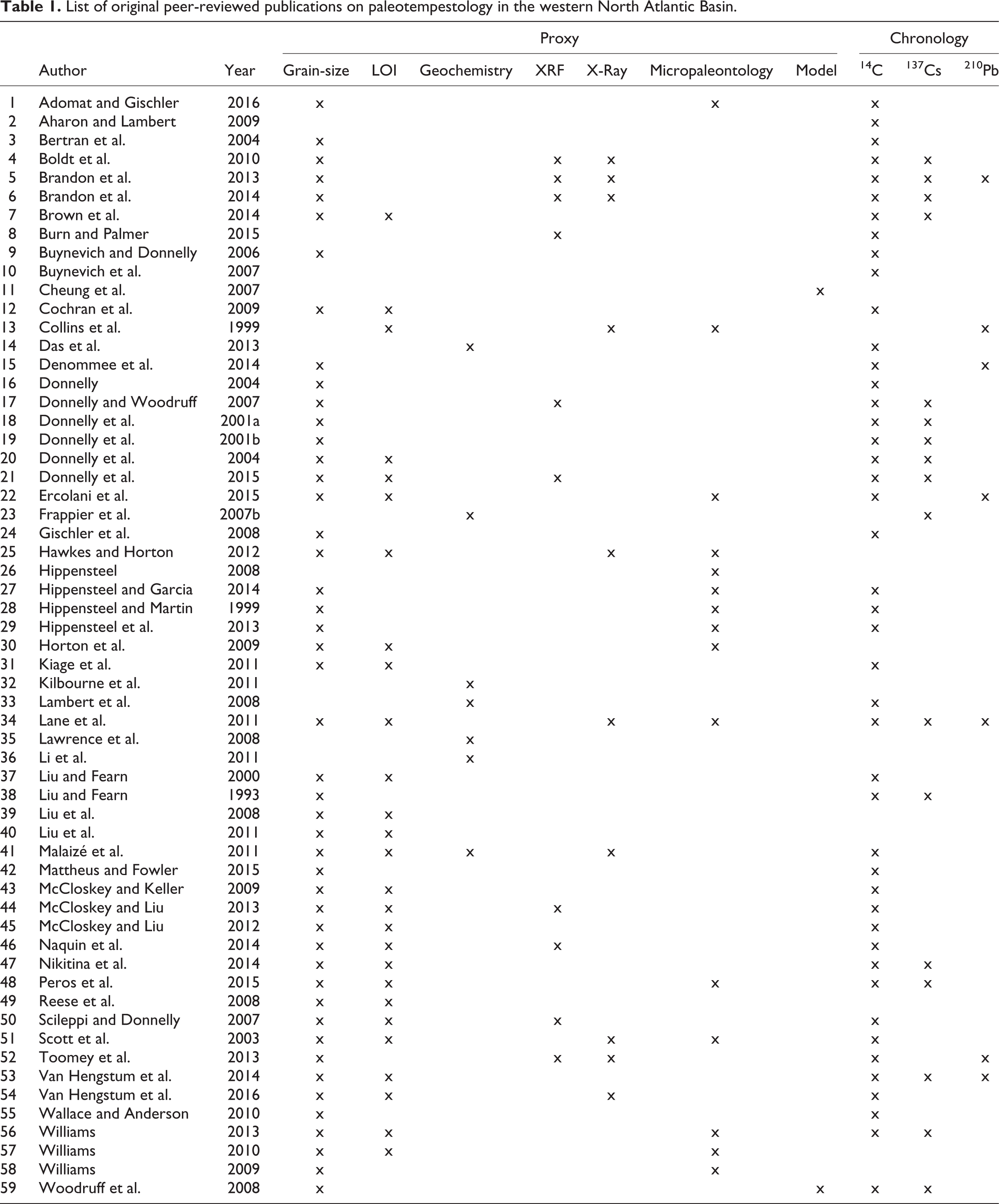
This list shows that 59 peer-reviewed papers presenting original data have been published on the paleotempestology of the western North Atlantic. Table 1 also identifies the specific proxy indicators and dating methods used in those studies. A majority of TC reconstructions (n = 47, or 80%) use grain-size analysis and/or the organic content of sediment cores (defined here as established proxies), while comparatively fewer studies have used other indicators, such as elemental composition as determined by X-ray fluorescence (XRF) (n = 9, or 15%), geochemical (n = 7, or 12%), and micropaleontological evidence (n = 15, or 25%).
A map of the spatial distribution of study sites (Figure 1) shows that they tend to cluster along the north coast of the Gulf of Mexico, the Carolinas, the north-eastern United States, and Belize, and that noticeable gaps are present along the Atlantic and Gulf of Mexico coasts of Florida, the islands of Cuba and Hispaniola, the Lesser Antilles and the Caribbean coast of Honduras (Figure 1). This distribution may reflect a combination of factors, such as the presence of suitable sampling locations, the likelihood of TC landfall, and even proximity to research institutions with staff focused on paleotempestological research (e.g. Louisiana State University, Baton Rouge, LA and the Woods Hole Oceanographic Institution, Cape Cod, MA). Moreover, no paleotempestology studies have been published along the North American coast north of Maine (Figure 1) (Buynevich et al., 2007) apart from federal government research inferring past hurricane activity based on soil profiles and forests (Ponomarenko, 2009).
Map of peer-reviewed study sites from Atlantic tropical cyclone. Red squares represent studies that used XRF, blue triangles are studies that used geochemistry, and the green circles represent studies that primarily used more established methods. Number corresponds to study ID (Table 1). Red areas are identified spatial gaps.
III Established proxies
1 Grain-size analysis
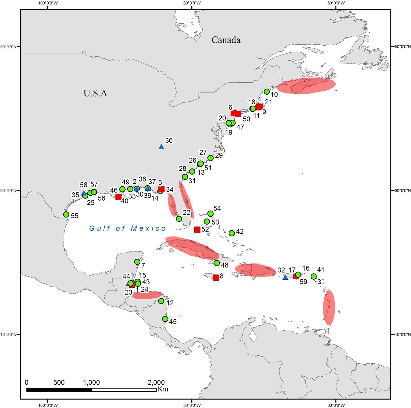
Grain-size analysis along a core can reveal much about past environmental changes, particularly as they relate to energy transport conditions (Donnelly and Woodruff, 2007; Liu, 2013). Normally-deposited material in low-energy environments such as coastal lakes and marshes is typically fine, organic-rich sediment. Coarser sediment layers are commonly used as evidence of an energy shift in the environment, such as sediment overwashing a barrier due to a storm surge coupled with intense wave activity (Figure 2) (Donnelly and Webb, 2004; Donnelly et al., 2001a, 2001b, 2004; Liu, 2013).

Effects of an advancing TC: storm surge breaching a barrier and bringing overwash into a freshwater coastal setting. Clouds carrying 18O depleted precipitation moving inland from the storm.
Researchers have used several techniques to generate grain-size data. Some have used a more qualitative approach which includes describing the presence of visible sand layers which are then attributed to past hurricane strikes, often based on a comparison of the timing of these sand layers with historically documented TCs (Donnelly et al., 2001a, 2001b, 2004; Hansom and Hall, 2009; Liu and Fearn, 2000; Liu et al., 2008, 2011; Scott et al., 2003). On a quantitative level, the sieving method, which works to separate particles into size fractions (often greater or less than 63 µm), is widely used (Brandon et al., 2014; Donnelly et al., 2015; Hippensteel and Martin, 1999; Kiage et al., 2011; Lane et al., 2011; Mattheus and Fowler, 2015; McCloskey and Keller, 2009; McCloskey and Liu, 2013; Reese et al., 2008; Williams, 2009, 2010, 2013) and can be an efficient way of determining key grain-size fractions, such as percent sand, in a sample. Laser particle size analyzers (LPSA) are a newer, more costly, yet more precise method for grain-size analysis and their advantage lies in their ability to generate a complete grain size distribution from a small sample in fractions much finer than what is possible with mechanical sieving (Boldt et al., 2010; Brown et al., 2014; Donnelly and Woodruff, 2007; Hawkes and Horton, 2012; Horton et al., 2009; Malaizé et al., 2011; McCloskey and Liu, 2012; Naquin et al, 2014; Nikitina et al., 2014; Peros et al., 2015; Toomey et al., 2013; Van Hengstum et al., 2014). When sieving or using a LPSA, most researchers have attempted to isolate the mineral (carbonate and siliciclastic) components so as to not bias a sample with organic particles which may not be related to the energy level.
One point that emerges from a review of the literature is that there is no standardized approach for the removal of organic matter; Boldt et al. (2010), for example, combusted their samples at 550°C in a furnace to remove organic matter before undertaking grain-size analysis, whereas Malaizé et al. (2011) used hydrogen peroxide (H2O2) to digest organic matter. There are no known studies assessing the effects of the use of different methods for the removal of organic matter on particle size distributions in paleotempestological research, and a comparative study examining the potential effects would be worthwhile. For example, the combustion of samples in a furnace is often used (e.g. Boldt et al., 2010), but it is unclear to what extent this may fuse fine particles together, especially in samples containing clay, potentially skewing grain size distribution results toward coarser particles (Vaasma, 2008).
2 Organic matter analysis
Loss-on-ignition (LOI), used to quantify the organic matter, total carbonate, and siliciclastic content (as a function of sediment dry weight), is another common method that has been used to provide information on past storm events based on the premise that a storm overwash layer will have less organic content than lagoon sediments deposited during periods of normal, low-energy sedimentation (McCloskey and Liu, 2012, 2013). All of the studies which analyzed organic content by LOI used a similar method laid out by Ball (1964), Dean (1974), or more recently by Heiri et al. (2001), which involves combustion in a high-temperature furnace followed by weighing the residue with a high-precision balance to estimate the mass lost in the sample. The only exception was Malaizé et al. (2011) who removed organic matter from their samples by pyrolysis (oxygen-less combustion).
3 Micropaleontological analysis
The most commonly used micropaleontological proxy in paleotempestology is benthic foraminifera (Hippensteel and Martin, 1999; Lane et al., 2011; Liu et al., 2008; Peros et al., 2007). Foraminifera are small (usually <1 mm) shelled amoeba, that include both benthic (bottom dwelling) and planktonic (water-column dwelling) species (Scott et al., 2001). Many benthic species are known to live in marginal marine habitats such as coastal marshes, mangroves, estuaries and lagoons. Storm surges transport and deposit offshore foraminifera into normally freshwater or brackish coastal settings such as lagoons and marshes where they are often preserved (Adomat and Gischler, 2016; Hippensteel and Martin, 1999; Murray, 2006) and it is the presence of these species that are used as indicators of past hurricane strikes (Collins et al., 1999; Hawkes and Horton, 2012; Hippensteel and Garcia, 2014; Hippensteel and Martin, 1999; Hippensteel et al., 2013; Horton et al., 2009; Lane et al., 2011; Scott et al., 2003; Williams 2009, 2010, 2013). The only species known in freshwater environments is Allogromiida, but many thrive in brackish marginal environments, so it is important to understand the salinity of the environment to differentiate allochthonous marine species from those that may form naturally in the wetland (Gupta, 1999). Some have also argued for the use of samples from unaffected sections of marshes as control markers for differentiating TC-deposited species to autochthonous species (Hippensteel and Martin, 1999; Hippensteel et al., 2013). A potential limitation in the use of foraminifera (and other micropaleontological indicators, see below) is based on salinity change in coastal wetlands—which results in a shift in species assemblages—unrelated to TC activity (Peros et al., 2015). For example, short-duration droughts or marine incursions related to the breaching of the barrier may result in an increase in lagoon salinity and a shift to species whose ecological tolerance is more typical or high salinity conditions (Peros et al., 2015). Such changes can be common in coastal environments and the interpretation of paleotempestological records can be facilitated through the use of multiple proxies.
Dinoflagellate cysts (a type of eukaryote marine phytoplankton) are another micropaleontological indicator that have been used to identify marine inputs into fresh- to brackish coastal wetlands based on their presence in lagoon deposits (Liu et al., 2008, 2011). In addition, the salinity at the time of deposition in a sediment core can be reconstructed using dinoflagellates as species inhabit environments with differing salinities, which can be useful to help reconstruct the evolution of the lagoon or wetland system in response to long-term changes in sea level and climate (Liu and Fearn, 2000). An understanding of how such systems change is critical to the interpretation of proxy indicators as the detectability of a TC may vary as the depositional environment changes (Hippensteel et al., 2013). Finally, in addition to dinoflagellates, other studies have also relied upon diatoms (Hansom and Hall, 2009; Liu and Fearn, 1993, 2000; Liu et al., 2008; McCloskey and Keller, 2009; McCloskey and Liu, 2012), pollen (Liu et al., 2008; 2011; McCloskey and Liu, 2012), ostracods (Malaizé et al., 2011), or bivalves (Van Hengstum et al., 2014) to identify or validate storm-surge-generated overwash layers.
IV Chronology building
According to the list of studies (Table 1), the three main absolute dating methods used in paleotempestological research are carbon-14 (14C), cesium-137 (137Cs), and lead-210 (210Pb). In many cases, 14C is used in conjunction with either 137Cs or 210Pb (or both) to establish a reliable core-chronology. Most studies which used 137Cs and 210Pb also relied upon 14C (Boldt et al., 2010; Brandon et al., 2014; Brown et al., 2014; Denommee et al., 2014; Donnelly and Woodruff, 2007; Donnelly et al., 2004, 2015; Liu and Fearn, 1993; Nikitina et al., 2014; Peros et al., 2015; Toomey et al., 2013; Williams, 2013; Woodruff et al., 2008). One paper solely used 210Pb dating (Collins et al., 1999) and one paper only used 137Cs (along with layer counting; Frappier et al., 2007b). Three studies utilized all three dating methods (Brandon et al., 2013; Lane et al., 2011; Van Hengstum et al., 2014).
Donnelly et al. (2001, 2015) and Nikitina et al. (2014) showed that bulk lead pollution can also be used to validate chronological findings for the historic period, without needing to use the specific 210Pb isotope. Others studies have used other independent means for validating their chronologies, for example the use of marine microfossils (Williams, 2013), pollen (Donnelly et al., 2001a, 2001b, 2015), and other elemental concentrations (Ti) (Woodruff et al., 2008). Brandon et al. (2014) and Williams (2013) have shown that 137Cs can also be used effectively to date individual TC events near the 1963 bomb pulse. Modern radiometric dating can also bring more insight into the depositional environment, as Denommee et al. (2014) used varying 210Pb activities to validate non-linear sediment accumulation rates, which is what would be expected in a sediment core preserving high magnitude depositional events, such as TC-induced sedimentation.
These radiometric techniques come with potential limitations as well. For example, in radiocarbon dating, one fundamental limitation is the reservoir effect, or old-carbon error. The reservoir effect happens when the sample has less 14C relative to the abundance of the isotope in the environment leading to an older radiocarbon age (Yu et al., 2007). In coastal settings in particular, where paleotempestological records are most likely to be generated, it is also essential to take into consideration the marine radiocarbon reservoir effect, which is the offset in radiocarbon age between terrestrial organisms and those who have marine derived carbon (e.g. mollusks) (Ascough et al., 2005). Limitations in 210Pb dating include, but are not limited to, the choice of model with which to calculate ages based on 210Pb activities. The two main models are the constant initial concentration (CIC) and constant rate of supply (CRS) models. The CIC model is used for sites with constant sedimentation rates and the CRS model is used when there are changes in the rates of modern sedimentation. Using the CIC model will yield erroneous results for cores with varying sedimentation rates (Ghaleb, 2009), which, as discussed, may be common in paleotempestological studies (Ghaleb, 2009).
V Geochemical methods
1 X-ray fluorescence (XRF) core scanning
In addition to the established proxies outlined above, the past decade has seen the introduction of a number of geochemical-based proxies in paleotempestological research. One of the analytical procedures used to generate such data is the use of XRF core scanning, which is essentially the use of a well-established analytical technique (X-ray fluorescence) arranged in a manner to enable sediment cores (and other materials, like speleothems) to be scanned at high precision (Kylander et al., 2011). One of the most widely used XRF core scanning systems is the Swedish built Cox Analytical Systems ITRAX (Boldt et al., 2010; Donnelly and Woodruff, 2007; Donnelly et al., 2015; Toomey et al., 2013). These machines typically provide sub-mm scale resolution of up to 62 elements in the range of aluminum to uranium, in addition to core x-radiography (Kylander et al., 2011). The high cost and infrastructure requirements of these units have also meant that smaller, faster, portable XRF systems (pXRF; such as the Olympus Delta Mining and Geochemistry handheld XRF Analyzer; McCloskey and Liu, 2013) have been used in the field (Weindorf et al., 2014) for paleotempestological research. These devices produce data at much lower spatial resolution (usually mm- to cm-scale) but have the advantage of being considerably cheaper and can be easily used in the field for exploratory work (Naquin et al., 2014).
The use of XRF technology has been applied to paleotempestological studies in three primary ways: (1) to develop an X-ray of the core to differentiate denser from less dense sections, with the former generally reflecting higher mineral-content and therefore TC-overwash material (Boldt et al., 2010; Brandon et al., 2014); (2) to generate very high-resolution elemental data with which to identify TC overwash events directly (Woodruff et al., 2009; Naquin et al., 2014); and (3) to date sections of the core (usually near the core top) based on the identification of increases in elements related to human activities such as mercury, or lead, which itself can be dated using the historical record (e.g. Brandon et al., 2014; Donnelly et al., 2015).
Core X-radiography has been shown to be a useful aid to help support grain-size based data, especially in cores where visual evidence of TC overwash events are not discernible (Toomey et al., 2013). However, this technique by itself is not fool-proof, as some cores show no evidence of either changes in grain size or density (e.g. Toomey et al., 2013), requiring the use of other techniques to detect hurricane-induced events. Thus, it is usually used as supporting proxy data, but is automatically generated by most XRF core scanning systems so it requires little time to be invested in data generation.
The use of elemental geochemical data to identify storm overwash layers rests on the assumption that hurricane storm surges transport and deposit allochthonous material with a different elemental signature than that contained in the low-energy autochthonous sediments. Research using this technique appears to be better developed in other basins (e.g. Pacific, Mediterranean). For example, Woodruff et al., (2009) showed that Sr (normally abundant in marine shells and other materials) was a good indicator of marine overwash in two coastal lakes in southern Japan. In addition, Sabatier et al. (2012) used ratios of Si/Al and Zr/Al to identify storm events in cores on the south coast of France, and showed that increases in these ratios were highly correlated with increases in sediment grain size. In the Atlantic Basin, Naquin et al. (2014) interpreted decreases in terrestrial indicators such as Ti, Fe, and Zn as evidence of TC overwash, although this data was only used to support LOI and grain size data already available for the core. In addition, McCloskey and Liu (2013) argued that increases in Fe, Ti, and Zn (again, identified as having a terrestrial origin) were associated with hurricane overwash in organic-rich peat sediments, possibly due to the reworking of terrestrial sediments by hurricane storm surges.
Finally, the use of XRF core scanning as a dating technique relies on the detection of a change in an element which can be linked to past human land use or industrial activities (much the same way as the “Ambrosia rise” is used in pollen analysis; McAndrews, 1988). This approach has been successfully applied to cores from locations such as in the northeastern United States (Boldt et al., 2010; Donnelly et al., 2015) where human impacts have been large and the timing of their initiation is well known. However, while this approach may be effective in some areas (e.g. Donnelly and Woodruff, 2007), it is not clear to what extent it would be applicable in more remote areas where the land use history is not well established or where human impacts have been gradual, rather than more abrupt, making the attribution of an increase in a certain element difficult to establish (Han et al., 2002). Nevertheless, this is a useful application of XRF technology to help refine historic-scale chronologies where Pb-210 data is unavailable.
Thus, at this stage, the use of very high resolution XRF data as an indicator of hurricane activity is still relatively uncommon. The reasons for this are unclear, but they may be due to: (a) the effectiveness of established methods (e.g. grain size) in paleotempestological study; (b) the lack of a clear understanding of which elements or element ratios best detect overwash; or (c) the lack of access to an XRF core scanning unit. It should also be emphasized that XRF elemental results have the potential to be used as a proxy of grain size itself; research such as Sabatier et al. (2012) and Cuven et al. (2010) has shown that sediment grain size is often correlated with certain elements (e.g. K, Fe, and Ti) and XRF core scanning may be a fast technique to estimate grain size without the effort of LPSA and potential problems associated with the removal of organic material (see above). XRF-generated grain size estimates would also be available at considerably higher resolution that most LPSA results, which are usually generated at 0.5 or 1 cm resolution, making the detection of much finer or shorter duration events possible (and thus it may enable cores of lower sedimentation rate to yield more data). The disadvantage of this approach is that at present, the use of XRF core scanning as a proxy for grain size is mostly qualitative and does not provide the full distribution of grain sizes possible with LPSA, which might be informative about past energy conditions and sediment source areas (Cuven et al., 2010).
Other limitations with XRF core scanning lie in the composition of the core. Cores composed of highly variable organic content (Löwemark et al., 2011) or inhomogeneous water content (Weindorf et al., 2014) or grain size (Weltje and Tjallingii, 2008) will change the composition of material that can be measured and cause the measured elemental data to vary, which may call for the data to be normalized (Löwemark et al., 2011) or calibrated (Weltje and Tjallingii, 2008). The effect of gaps, cracks and uneven sample surfaces in the core can also cause erroneous results and affect the overall quality of the data (Löwemark et al., 2011).
2 Stable isotopic geochemical indicators
TCs tend to have a unique isotopic signature, with hurricane rainwater being depleted of heavier oxygen isotopes by up to 10‰ compared to normal rainwater (Figure 2; Lawrence and Gedzelman, 1996), making the use of stable isotope chemistry an important technique in paleotempestological research (Frappier et al., 2007b; Kilbourne et al., 2011; Kolodny et al., 2009; Lawrence et al., 2008; Li et al., 2011). Some researchers have also analyzed isotopes of carbon, nitrogen, or a combination of these elements (Das et al., 2013; Frappier et al., 2007b; Lambert et al., 2008; Li et al., 2011, Malaizé et al., 2011). The materials typically analyzed for isotope geochemistry include calcareous microfossils (such as ostracodes) in sediment cores (Das et al., 2013; Lawrence et al., 2008; Malaizé et al., 2011), stalagmites (Frappier et al., 2007b), corals (Kilbourne et al., 2011), rock samples (Kolodny et al., 2009), organic material extracted from sediment cores (Lambert et al., 2008), and tree ring cellulose (Li et al., 2011). Here we focus on their use in (i) tree rings, (ii) speleothems, and (iii) coastal sediments, as we believe these represent potentially important new areas of research that should be the focus of additional work by the paleotempestological community.
Tree rings
Time series of oxygen isotopes have shown decadal to multi-decadal variations in TC activity (Lawrence and Gedzelman, 1996; Miller et al., 2006). Since oxygen isotope values in tree ring cellulose mainly reflect the source water used by the tree, TC water depleted in δ18O should be discernable in the stable isotopic signature of tree rings (Miller et al., 2006). As precipitation from a TC infiltrates the soil it will be assimilated by the tree, leaving its isotopic signature within the cellulose that fed off that specific event. However, depending on local edaphic and geomorphic conditions, this TC water may only be captured in the cellulose up to a few weeks after an event (Miller et al., 2006). Tree species with shallow root systems, such as most Pinus (pine) species, will be more affected by soil water, making them particularly sensitive species for detecting TC activity (Anderson et al., 2002). Many factors can affect the amount of TC-derived water which will be incorporated into tree ring cellulose, such as the amount of precipitation available in the immediate vicinity of the tree and the infiltration and drainage capacity of the soil (Miller et al., 2006). Because of these factors, the isotope values can be a reliable proxy of TC past frequency, but not of intensity (Miller et al., 2006). In addition, certain physiological effects can affect the isotope values, such as carbonyl and water interactions that happen during biosynthesis, water-sucrose exchanges through the xylem, and oxygen fractionation due to leaf transpiration (Anderson et al., 2002). Luckily, these physiological effects are typically consistent within the same species, meaning that they can be largely controlled for by undertaking a species-specific tree-ring analysis (Anderson et al., 2002, Miller et al., 2006). Moreover, tree ring isotopic records are sensitive to dating uncertainties due to false and missing rings, but these problems can be mitigated for by developing a large dataset (often 50–100 trees) and cross-dating to develop a master chronology (Speer, 2010) to help select the most reliable samples for isotopic analysis.
Speleothems
Like tree rings, speleothems also represent a promising, albeit little-used, source of stable isotopic data of past TC strikes that is of high temporal resolution (Frappier et al., 2007b; Malmquist, 1997). Speleothems are accretions formed by the dissolution of limestone or dolomite in karstic subterraneous caverns, passages and water basins which are formed by soil water percolating and infiltrating underground (Ford and Williams, 2007). The limestone drip solution solidifies in layers, which in regions with well-defined seasonal precipitation can produce annual-scale features. In the case of TCs, the δ18O depleted precipitation will leave its isotopic signature in the speleothems (McDermott, 2004). For example, Frappier et al. (2007b) reconstructed a 23-year record of TC activity using a rapidly forming calcite stalagmite in Belize. The δ18O and δ13C data generated from this stalagmite covered the period AD 1977 to 2000 at weekly to monthly resolution. The study showed that excursions in δ18O and δ13C were highly correlated with known TC strikes, indicating that the method likely has utility in longer (pre-instrumental) speleothem records (Frappier et al., 2007b).
The use of speleothems for paleotempestology has many advantages, not the least of which is the high temporal resolution possible. In addition, karstic environments can be completely sheltered from exterior meteorological factors such as temperature and humidity, meaning that changes in stable isotopic ratios are more likely to be associated with TCs (McDermott, 2004). Moreover, caves are generally humid, limiting the evaporation of the precipitated water, thus limiting kinetic fractionation (McDermott, 2004). Despite this, not all caves and speleothems are appropriate for sampling. Frappier (2008) defined a screening process to help identify the most sensitive speleothems for paleotempestological research, which consisted of the following criteria: (1) sampling fast-growing speleothems to ensure short-lived hurricane events are recorded; (2) sampling in caves surrounded by thin soils to enhance the infiltration of TC rainwater; and (3) analyzing speleothems that have had minimal recrystallization or disturbance.
Organic chemical proxies
The use of organic geochemical proxies (OGPs) in paleotempestology is an understudied area but it may bring important new insight where established proxies cannot (Das et al., 2013; Lambert et al., 2008). OGPs can be used to identify the source of the organic matter in sediment cores, such as whether it is terrestrial, lacustrine or marine, and in doing so identify changes in the state of a wetland that might be related to TC activity (Das et al., 2013). Specifically, an isolated coastal freshwater lake will have organic matter with relatively lower δ13C and δ15 N values than organic matter from a state in which it is flooded or inundated after a storm surge (Das et al., 2013). Nutrient supplies from marine water intrusion and enhanced light penetration will stimulate algal growth (i.e. eutrophication; Lambert et al., 2008), and the marine organic matter entering the basin will have higher δ13C, δ15 N, and C/N values compared to lacustrine organic matter (Das et al., 2013; Lambert et al., 2008). These proxies were investigated at Lake Shelby, Alabama, and excursions in those isotopic ratios correlated closely with hurricane-generated sand layers at this site (Lambert et al., 2008). Indeed the results of this study showed that 11 catastrophic hurricanes hit the Lake Shelby coast over the last 682 years and that the ability to detect severe hurricanes using this isotopic method was significantly increased over the established proxies (Das et al., 2013).
VI General limitations
In addition to proxy limitations, paleotempestological reconstructions can also be hampered by the characteristics of the study site, sea level change, and other processes (Wallace et al., 2014). At the site level, long-term changes in barrier height and width can affect the ability of overwash to enter a lagoon, with increases in these dimensions (due to geomorphic processes such as enhanced sedimentation) reducing the sensitivity of a site to overwash and hence appearing as though fewer hurricane strikes occurred (Otvos, 2011). In addition, other processes that result in the deposition of coarse grained material, such as floods due to (non-hurricane) high energy precipitation events, aeolian processes, high tides, and sediment winnowing, might help concentrate coarser particles and yield a “false positive” (i.e. a sand layer not deposited by a hurricane; Otvos, 2009, 2011). Relative sea level rise is also a potentially complicating factor, as lower past sea level positions would decrease the sensitivity of a lagoon or a coastal lake to overwash as the shoreline would have been located in a more seaward position in the past (Liu and Fearn, 2000). It is therefore helpful to understand local relative sea level history at a given site when interpreting long paleotempestological records to assess whether an apparent decrease in coarse layers with time is due to a real decrease in hurricane activity or a different past shoreline position. In addition, the question of tsunamis is frequently raised in the literature (e.g. Toomey et al., 2013), and there are no clear methods for differentiating between tsunami- and hurricane-generated deposits (McCloskey and Keller, 2009). Despite this, the occurrence of tsunamis is much less frequent than that of hurricanes, at least in the western North Atlantic basin (McCloskey and Keller, 2009), and tsunamis are unlikely to be significant contributors to coastal sedimentary deposits. Finally, anthropogenic factors can disrupt sedimentation in coastal environments (Lane et al., 2011; McCloskey and Liu, 2012) making the detection of recent hurricanes in the sedimentological record difficult.
VII Future directions
Based on the work in this paper, we suggest three areas where we believe the paleotempestological community could focus its research efforts.
1 The development of an online paleotempestological database
We argue that the building of a searchable, publically and freely available, online database archiving the raw data from these studies would greatly enhance research efforts in this field. The database need not be restricted to the western North Atlantic region but could be global and would include information on the proxy data (e.g. grain size measurements, isotopic values), chronologies and age-depth models, details about the sampling site (e.g. physiographic information about lagoon barrier height and width, vegetation, etc.), and the technology used to collect the sample (e.g. coring equipment). The methodologies used, even though often available in publications, would allow researchers to better understand the potentials and limitations of the data from each site. The availability of this information would also facilitate the comparison of records within and between sites, providing more information on spatial and temporal variability in paleotempestological records. Some online resources do already exist; for example, the National Climatic Data Center (NCDC) of the National Oceanic and Atmospheric Administration (NOAA) has a “Paleotempestology Resource Center” page (http://www.ncdc.noaa.gov/paleo/hurricane/links.html), although it was last updated in February 2012 and contains few datasets. It should also be noted that some paleotempestological records are also available through the Paleoclimatology Data Search engine of the NCDC website (and researchers who have contributed data should be thanked), but a single database devoted to paleotempestology would be effective for researchers in this field. One possibility would be to model such a database after the Neotoma Paleoecology Database, which in addition to searchable data also includes information on news highlights, events, and public outreach activities in the area of paleoecology (http://www.neotomadb.org/about/category/about).
2 Regional-scale syntheses of paleotempestological data
Given the recent proliferation of paleotempestological records from individual sites (Table 1) and the increasing spatial density of coverage in the western North Atlantic region (Figure 1), we argue that it is time to go beyond just the generation of individual paleotempestological records and their comparison to other datasets in papers (e.g. Peros et al., 2015) to begin to more systematically analyze temporal and spatial differences in paleotempestological records. How consistent are the presence of “active” hurricane periods identified at some sites (e.g. Donnelly and Woodruff, 2007) across space? If these periods occur elsewhere, is their occurrence synchronous or do they occur in a time-transgressive manner? A time-transgressive model of enhanced hurricane activity has been proposed that involves a latitudinal migration of the Intertropical Convergence Zone (ITCZ) as a driving mechanism during the middle to late Holocene (McCloskey et al., 2012; Van Hengstum et al., 2016). Testing of hypotheses related to identifying the main drivers of centennial- to millennial-scale hurricane patterns would be enhanced by generating a time-series of region-wide maps highlighting active versus inactive period variability. Such maps would be analogous to fossil pollen-based reconstructions of North American temperature anomalies (Viau et al., 2006) and would more easily permit potential driving factors (e.g. sea surface temperatures, ITCZ position) to be compared to the paleotempestological data in order to better understand the causes of long-term hurricane variability.
3 The generation of new paleotempestological records from areas on the margins of hurricane tracks
The space in which North Atlantic hurricanes occupy today is shown in Figure 3. The southern boundary of this zone is approximately parallel to the north coast of South America whereas the northern boundary is more diffuse and extends north of the Canadian Atlantic Provinces. Most paleotempestological reconstructions have been undertaken at sites near the center of this zone, such as the northern Gulf of Mexico coast (e.g. Liu and Fearn, 2000), Belize (e.g. McCloskey and Keller, 2009), and the Bahamas (e.g. Van Hengstum et al., 2016). We propose that it would be beneficial to the understanding of long-term processes controlling hurricane frequencies and patterns to also examine sites at the margins of this zone, as different atmospheric and oceanic circulation patterns in the past (i.e., warmer sea surface temperatures) may have increased the space over which this zone occurs, particularly at its northern limit. For this reason, we suggest that an investigation of sites in the Canadian Atlantic Provinces and the southern Caribbean would be advantageous. A cursory analysis of potential coring locations, based on some of the criteria outlined by Wallace at al. (2014), indicates the presence of a few potential sites on the islands of Bonaire and Grenada (Figure 3). Likewise, there are many coastal lakes and ponds located on the Atlantic coast of Nova Scotia that could be examined. One potential difficulty that may be encountered at high latitude sites could be differentiating TCs from mid-latitude winter storms (i.e. “nor’easters”) in the paleotempestological record but this can be accomplished by selected coring locations that are oriented such that winter storms have minimal impact (Boldt et al., 2010). Indeed, the idea of examining hurricane track boundaries is analogous to the concept of studying major ecological boundaries (i.e. “ecotones”) in paleoecology and palynology as it is in these locations that change is expected to be most prominent and detectable in the fossil record (McAndrews, 1966; Williams et al., 2009).
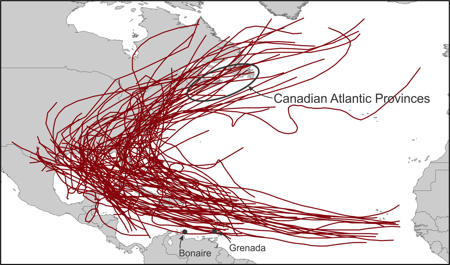
Paths of all tropical cyclones and major hurricanes from 1851 to 2004 that crossed the United States (National Oceanic and Atmospheric Administration, Tropical Prediction Center/National Hurricane Center).
VIII Conclusion
When Hippensteel (2010) writes about the pursuit of the perfect proxy for paleotempestology reconstructions, he focuses on sedimentary- and ecological-based indicators. Sedimentary research related to the identification of coarse sand layers, ecological work identifying offshore foraminifera, and the use of other proxies such as loss-on-ignition, are still indispensable and robust methods for paleotempestological research and have helped advanced the field considerably. However, new technologies (e.g. XRF core scanning) and non-established paleoenvironmental archives (at least as applied to paleotempestology, such as tree rings) provide an opportunity to expand the scope of paleotempestological research to new sites and to generate records at considerably higher temporal resolution, sometimes at the annual or even seasonal scale.
For example, researchers have begun to use stable isotope geochemistry (Das et al., 2013; Frappier et al., 2007b; Kilbourne et al., 2011; Lawrence et al., 2008; Li et al., 2011), XRF core scanning (McCloskey and Liu, 2013; Naquin et al., 2014), and X-radiography (Boldt et al., 2010; Hawkes and Horton, 2012; Lane et al., 2009) to study past TC variability. Stable isotopes from tree rings have the potential for increasing both the spatial and temporal (i.e. seasonal) resolution of paleotempestological studies, although they have not yet been widely applied, and it is unclear if long (e.g. 1000 year) timescales can be generated with them. Analyzing the geochemical properties of speleothems is also a very promising method for studying paleotempestology but it is an area of research that remains in its infancy. However, the sampling protocol for speleothems described by Frappier (2008) opens the door to potentially seasonal-scale resolution at much longer (>10,000 years) timescales than many other existing methods allow.
In this paper we also reviewed the spatial distribution of paleotempestological studies in the Atlantic Basin and showed that many gaps exist along the coast of eastern North America, in the Gulf of Mexico, and in the Caribbean. There are a number of reasons for this, but the use of a wider range of proxy indicators by the paleotempestological community will help fill these gaps by increasing the number of potential sites from which data can be generated. Such efforts will help to develop a more comprehensive and spatially homogenous coverage of paleotempestological records to be able to better test hypotheses concerning the factors that drive TC frequency changes in the Atlantic Basin (e.g. ITCZ hypothesis; McCloskey et al., 2012; Van Hengstum et al., 2016). In addition, synoptic-scale analyses of TC variability will also be assisted with the building of publically-available online databases where paleotempestological records can be housed, accessed, and analyzed, with the view to producing regional-scale syntheses.
Footnotes
Declaration of conflicting interests
The authors declared no potential conflicts of interest with respect to the research, authorship, and/or publication of this article.
Funding
The authors disclosed receipt of the following financial support for the research, authorship, and/or publication of this article: Funding support to M.Peros from the Canada Research Chairs program and to A. Viau and M. Peros from NSERC is greatly appreciated.