
Abstract
Geomorphic context refers to the geomorphic setting of a river reach, which is defined as a length of river with consistent valley and channel geometry. Context includes spatial dimensions of geometry, location within a drainage basin, and location within a global context. Context also includes temporal dimensions of the frequency and duration of specific processes influencing the river reach and the historical sequence of natural and human-induced processes that continue to influence process and form in the river reach. These spatial and temporal characteristics interact to create a geomorphic context that governs the contemporary form of the river corridor, the rates and processes by which diverse materials move through the corridor, and the adjustments of form and process in response to disturbances. Context matters for both basic understanding and effective management of river corridors. Examples of widely used formal articulations of geomorphic context include a bedform-based classification of mountain streams, geomorphic process domains, and river styles. Each has been applied to understanding and predicting longitudinal variations in stream power, sediment budgets, habitat and biotic communities, resilience to disturbance, and other characteristics of rivers. The three Cs of rivers—complexity (or spatial heterogeneity), connectivity, and context—provide a conceptual framework for river research and management.
I What is context?
This paper is the third and final in a series of progress reports focusing on different aspects of contemporary understanding of rivers. Rivers here include the features sometimes described as a river corridor (Harvey and Gooseff, 2015): the active channel(s), floodplain, riparian zone, and hyporheic zone. The first paper examined spatial heterogeneity as a component of river geomorphic complexity (Wohl, 2016). The second paper reviewed connectivity in rivers (Wohl, 2017). This paper takes up the third C of rivers—context. Considerations of context have a long history in fluvial geomorphology. This paper briefly reviews that history and some of the recent literature that emphasizes the importance of context in understanding and managing river process and form.
Context here refers to the geomorphic setting of a river. Geomorphic setting includes both spatial and temporal components (Figure 1). Spatial dimensions describe the geometry of a river reach, the location of that reach within a drainage basin, and the location of that drainage basin within a global context of climate, lithology, tectonics, and biome. River reach refers to a length of river corridor with consistent valley and channel geometry. A reach could be 10 m long for a small river and 103–104 m long for large rivers.
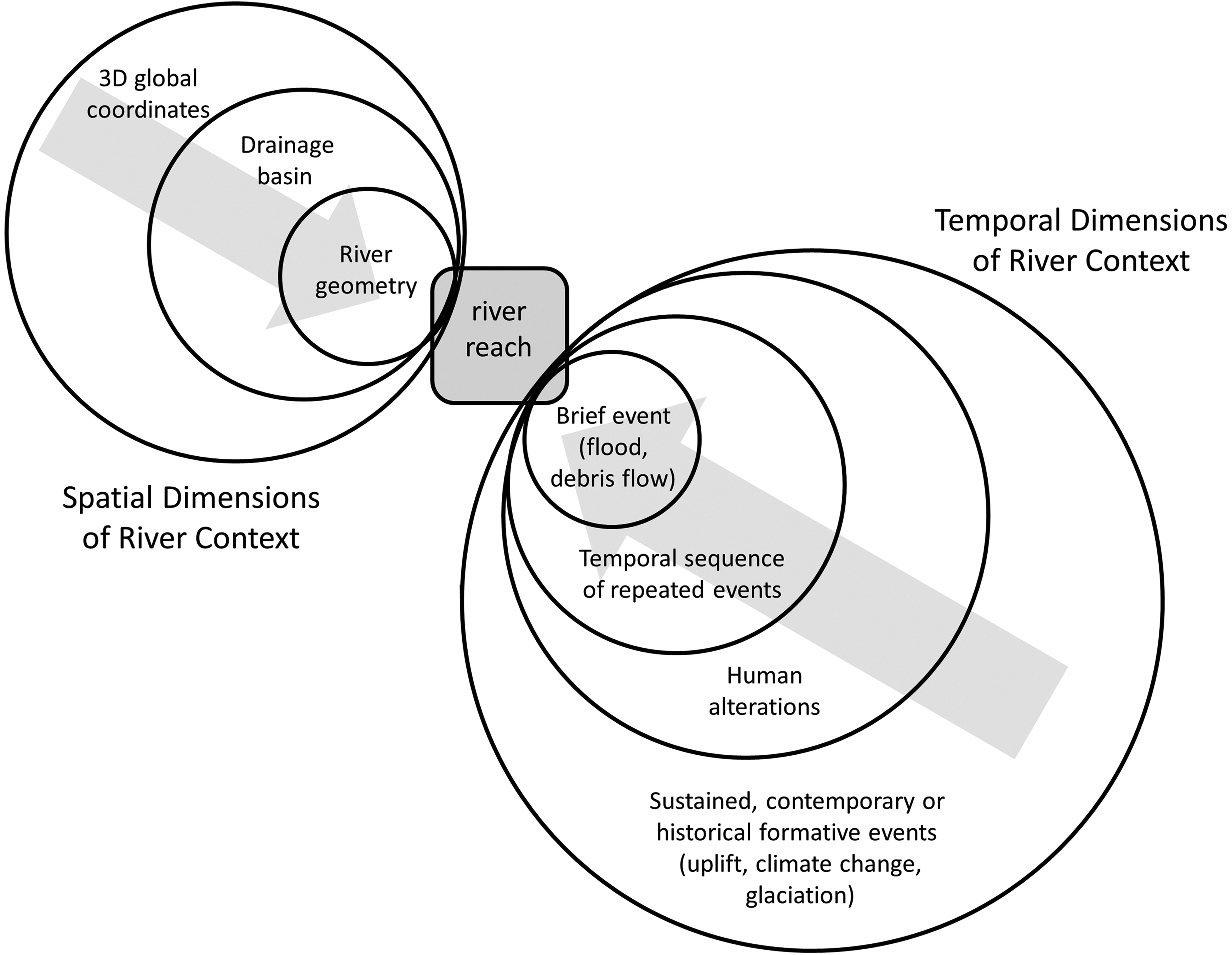
Schematic representation of the two components of geomorphic context for a reach of river corridor. With respect to the spatial dimension, a river reach includes valley and channel geometry of the reach; drainage basin represents location of the reach within a river network; 3d global coordinates indicate latitude, longitude, and elevation of the river reach, which locates the river reach in a specific environment with respect to climate, lithology, tectonics, and biome. The gray arrow crossing the nested circles represents the understanding that variables acting at multiple spatial scales affect an individual river reach. With respect to the temporal dimension, the history of recent, relatively brief events; the magnitude and frequency of repeated events; human alteration; and sustained events such as climate change or tectonic uplift all influence contemporary process and form in the river reach. The gray arrow crossing the nested circles represents the continuing influence of events that occurred at differing times throughout history.
Temporal dimensions describe the frequency and duration of specific processes influencing the river corridor from outside the corridor (e.g., mass movements from adjacent uplands) and within the river corridor (e.g., floods, recruitment of large wood from the floodplain). Processes here refer primarily to dynamics (inputs, transport, storage, and outputs) of water, sediment, and, in forested drainages, large wood. Temporal dimensions also include the history of formative events that continue to influence form and process within a river reach after the event ceases.
1 Spatial dimensions of context
Geomorphologists have long recognized the importance of spatial context for river process and form. Leopold and Maddock (1953) used the framework of downstream hydraulic geometry to describe progressive downstream changes in width, depth, and velocity of flow in response to changes in contributing area and discharge. Schumm (1977) described longitudinal zonation of drainage basins with respect to primarily source, transport, and depositional zones and Church (2002) built on these ideas to describe a characteristic sequence of morphological types present from uplands to distal channels and separated by thresholds of process and form. Others have emphasized discontinuities or interruptions of longitudinal trends associated with tributary junctions (Benda et al., 2004; Rice, 1998), knickpoints (Berlin and Anderson, 2009; Stock and Montgomery, 1999), or hydroclimatic boundaries (Grimm et al., 1995). Whether the emphasis is on progressive downstream trends or on spatial contingency—dependence on local conditions (Gregory and Lewin, 2014)—recognition of the importance of location as an influence on river process and form is explicit.
With respect to the three spatial dimensions of context in Figure 1, the geometry of a river reach includes the physical configuration of both channel and valley, as characterized by metrics such as the ratio of channel to floodplain width, presence of landforms such as alluvial fans that influence connectivity (Fryirs et al., 2007), downstream gradient, channel planform, and channel bedforms. The geometry of a river reach strongly influences both the form and process of a river corridor at any given moment and the manner in which the river corridor adjusts to disturbances such as floods (Figure 2). A steep, narrow geometry, for example, limits energy dissipation during large floods and is likely to correspond to predominantly erosion, whereas a wider, lower gradient geometry is likely to correspond to deposition during floods (e.g., Shroba et al., 1979).
The concept of disturbance comes from ecologists, who define disturbances as relatively discrete events in time that disrupt ecosystem, community, or population structure and change resources, substrate availability, or the physical environment (White and Pickett, 1985). In physical geography, disturbance commonly refers to a discrete physical event such as an intense rainstorm, landslide, or flood. The adjustment of a river corridor to disturbances can be expressed as resilience, which includes both resistance of the river corridor to change (Webster et al., 1975) and the rate and completeness with which the river corridor returns to pre-disturbance conditions (Holling, 1973). A resilient river corridor resists change and/or recovers quickly to pre-disturbance conditions. Use of the term resilience, which originated in ecology, is now common in physical geography (e.g., Biron et al., 2014; Fryirs and Brierley, 2000; Gilvear, 1999).
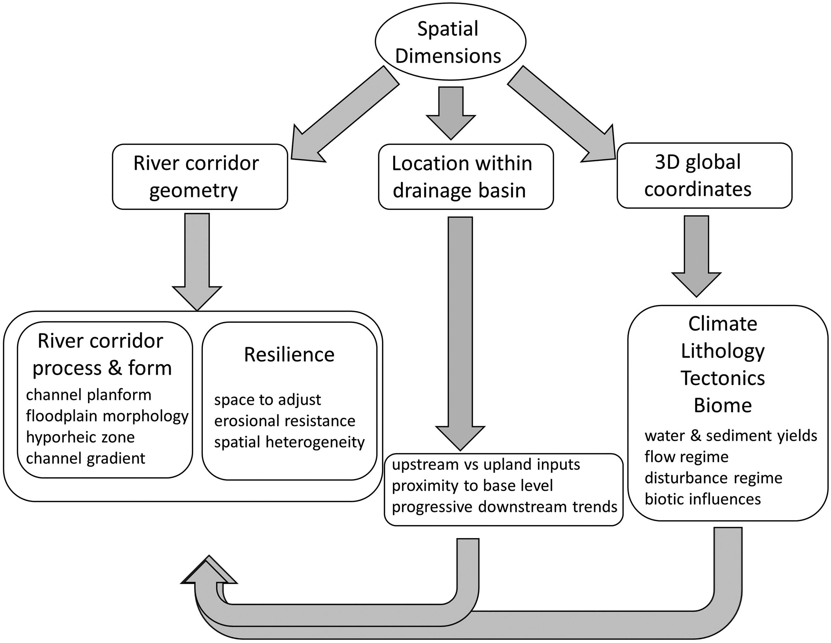
Schematic illustration of the different characteristics that constitute the spatial dimension of river context and their interactions with each other.
Earlier descriptions of resilience include landscape sensitivity and transient and persistent landforms (e.g., Brunsden and Thornes, 1979; Fryirs, 2017; Harvey, 2001; Thomas, 2001). Transience and persistence, which are commonly defined in terms of the duration of a specific landform relative to the frequency of the process creating that landform, also involve consideration of the temporal dimensions of context (i.e., recurrence interval of disturbances). In a fluvial context, a braided planform created by a flood is persistent if the river maintains a braided planform until a flood of similar magnitude recurs, and transient if the planform changes before a flood of similar magnitude recurs (e.g., Friedman and Lee, 2002). A related conceptual framework is that of equilibrium, disequilibrium, and nonequilibrium landforms. Equilibrium landforms exhibit a constant relation between input and output or form, toward which the landform either tends or around which it fluctuates in time (Renwick, 1992). Disequilibrium landforms tend toward equilibrium but have not had sufficient time to reach such a condition, whereas nonequilibrium landforms do not tend toward equilibrium even with long periods of environmental stability, but instead repeatedly undergo frequent and large changes in form (Renwick, 1992; Tooth and Nanson, 2000).
Continuing with the different components of spatial context in Figure 1, the location of a river reach within a drainage basin can be understood in terms of position along the longitudinal profile. Position along the profile can reflect progressive downstream trends in channel substrate (Frings, 2008), lateral extent of floodplain (Ralph and Hesse, 2010), valley and channel gradient (Leopold et al., 1964), discharge, stream power (Knighton, 1999), channel dimensions (Leopold and Maddock, 1953), and the magnitude of diverse forms of connectivity (Brierley and Fryirs, 2005; Wohl, 2017). Position along the profile can influence proximity to base level and thus rate and magnitude of adjustment to changes in relative base level (Berlin and Anderson, 2009; Wobus et al., 2006). Position along the profile can also influence the relative importance of inputs from tributaries and upstream portions of the river network versus inputs from adjacent uplands (Gomi et al., 2002; Meade, 2007; Walling and Collins, 2008). Finally, position along the profile can be considered in terms of position relative to other river reaches. The first lower gradient, less laterally confined reach downstream from a steep, narrow river reach, for example, is likely to accumulate material (coarse sediment, large wood) that was readily transported through the upstream reach (e.g., Wohl and Cadol, 2011).
Location of a drainage basin within a global context reflects climate, lithology, tectonics, and biome. These factors together influence water and sediment yields from uplands, flow regime, disturbance regime, and biotic influences such as beaver, large wood, and riparian vegetation (Figure 2).
2 Temporal dimensions of context
As noted earlier, temporal dimensions include the frequency and duration of specific processes influencing the river corridor and the history of occurrence of those processes. Geomorphic recognition of the importance of temporal dimensions of context includes Schumm and Lichty’s (1965) formulation of how relations among variables change in relation to timescale. The gradient of a river reach, for example, can be an independent variable over short timescales but a dependent variable over longer timescales. Concepts of transient versus persistent (Brunsden and Thornes, 1979) and equilibrium versus disequilibrium landforms (Renwick, 1992) are inherently tied to timescales. Historical contingency describes how contemporary process or form can be dependent on past events (Gregory and Lewin, 2014). Historical contingency can include inheritance, path-dependence, or dependence on initial conditions (Phillips, 2006).
Historical contingency recognizes the continuing importance of past formative events. Starting with the most recent history, a formative event could be the last large flood or debris flow. Over longer timespans, the sequence of processes that have influenced the river corridor from outside (e.g., base level drop) and within (e.g., downstream movement of sediment inputs) the corridor also create geomorphic context. The temporal sequence of repeated disturbances such as floods or debris flows can strongly influence the adjustment of a river reach to the most recent disturbance (Hooke, 2015). Large floods are less likely to create geomorphic changes in river corridor form, for example, where a flood of similar magnitude has occurred relatively recently (e.g., Cenderelli and Wohl, 2003; Harvey, 1984). Analogously, high-magnitude rainfall may result in lower yields of sediment and large wood from adjacent uplands if a previous storm has stripped uplands of sediment and vegetation too recently for weathering and vegetation regrowth to restore upland supplies (Soja and Starkel, 2007).
History also includes historical human alterations such as changes in land cover associated with agriculture or flow regulation and sediment storage associated with dams. A well-documented example comes from the Upper Mississippi Valley Hill country of the north-central USA, where nineteenth-century clearance of native vegetation for agriculture triggered increased sediment yields that gradually moved downstream through watersheds, causing aggradation and incision that were asynchronous along a channel and between the main stem and tributaries. These changes in river process and form continued for decades after the upland vegetation recovered (Trimble, 2013). Another striking example comes from abandoned eighteenth and nineteenth century milldams in the Mid-Atlantic Piedmont region of the USA. Closely spaced dams stored upland sediment eroding from croplands. This resulted in complete burial of floodplain wetlands and shallow, multi-channel valleys, transforming the valley bottoms into sinuous, gravel-bed rivers bordered by thick alluvial floodplains, a configuration that persists today despite substantial bank erosion (Walter and Merritts, 2008).
The history of human alterations can also influence temporal dimensions of processes by altering disturbance regime. Examples include drainages where wildfire suppression results in less frequent but more severe wildfires that change water and sediment yields from uplands to river corridors (Shakesby and Doerr, 2006) or flow regulation suppresses large floods (e.g., Magilligan et al., 2003).
Finally, history includes singular, formative events that are no longer active but which continue to influence aspects of context such as topographic relief in the drainage basin or valley geometry. Examples include continuing adjustment to relative base level change, expressed as bedrock knickpoints that persist for millennia following base level stabilization (Loget and Van Den Driessche, 2009), and Pleistocene valley glaciation that created differences in valley geometry and river form that persist for millennia after the glaciers retreat (Amerson et al., 2008; Anderson et al., 2006; Livers and Wohl, 2015).
3 Examples of the influence of context
Differentiating spatial and temporal dimensions of context is to some extent artificial because of the interconnectedness of these dimensions. Spatial characteristics strongly influence temporal dimensions, for example, because location influences frequency and duration of inputs to a river corridor. The highest values of discharge per drainage area, for example, occur where steep topography is present and regional atmospheric conditions produce large precipitation volumes (O’Connor and Costa, 2004). As another example, a headwater river reach in a high-relief drainage basin is likely to have more frequent mass movements of sediment and large wood into the river corridor than a river reach farther downstream in the drainage (Benda et al., 2003). Differences in frequency and duration of processes in turn influence river corridor process and form, as well as resilience. In a forested catchment, a river reach that frequently receives large wood from upstream and from adjacent hillslopes is more likely to have an alluvial bed and function as a sediment storage zone than a river reach that lacks large wood inputs (Brooks et al., 2003; Montgomery et al., 2003).
In summary, the spatial and temporal characteristics of a river reach interact to create a geomorphic context that governs the contemporary form of the river corridor, the rates and processes by which diverse materials move through the corridor, and the adjustments of form and process in response to disturbances. This can be illustrated using the two contrasting examples in Figure 3.
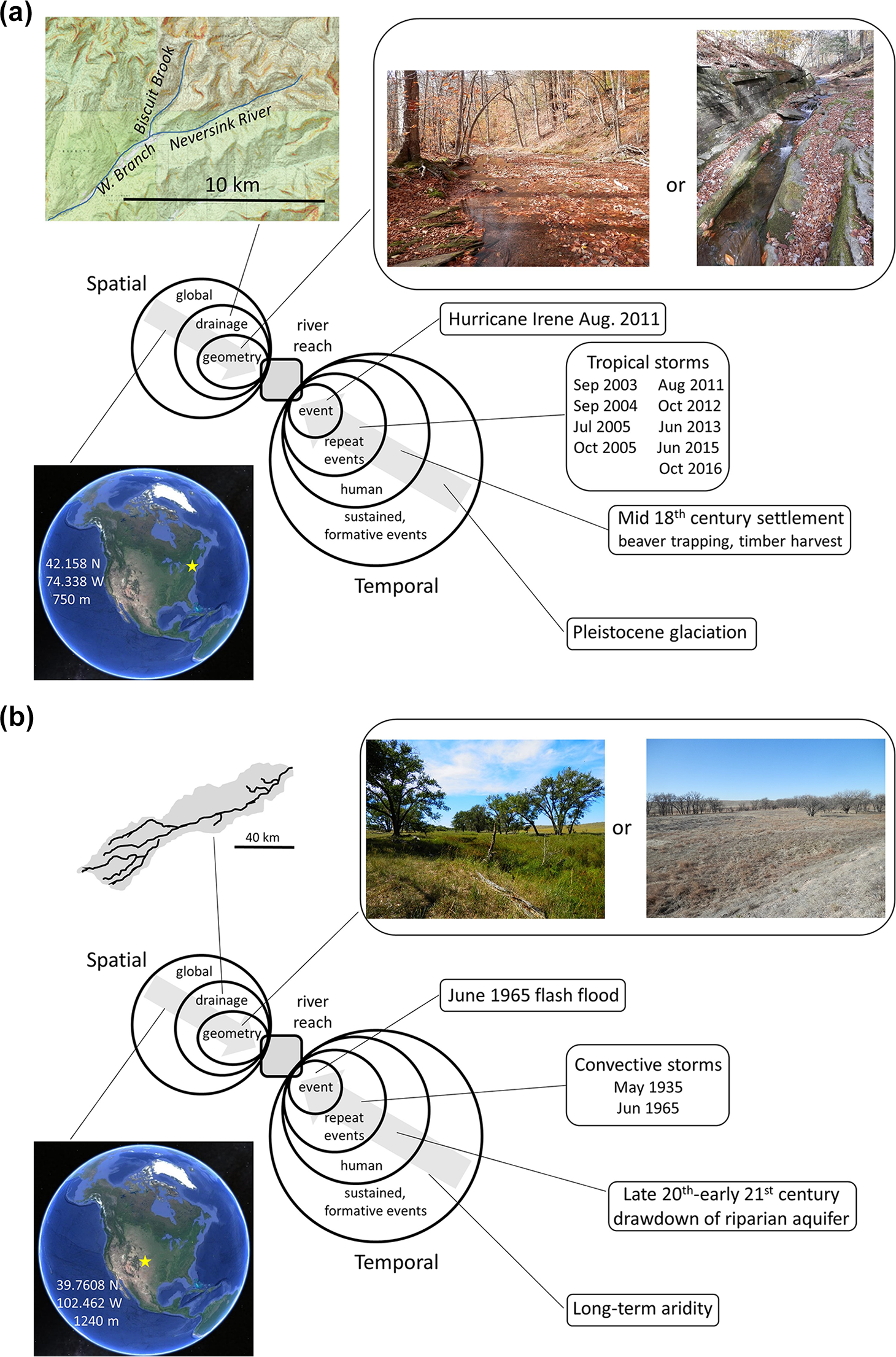
Illustration of spatial and temporal dimensions of geomorphic context. (a) Biscuit Brook in New York, USA. (b) Arikaree River, Colorado, USA. See text for discussion.
Biscuit Brook (Figure 3(a)) drains 10.7 km2 within the Neversink River drainage in the Catskill Mountains of New York, USA. Mean annual precipitation is approximately 1600 mm including snow. At the reach scale, valley geometry alternates downstream between relatively wide, low gradient, alluvial reaches (left photo at upper right) and narrow, steep, bedrock reaches (right photo at upper right). The entire length of the valley, however, is confined relative to comparably sized drainages in low-relief environments. Biscuit Brook is a headwater tributary of the West Branch Neversink River and the Biscuit Brook watershed has steep valley slopes that are highly connected to the river corridor. The entire drainage is located at 42°N, with a humid temperate climate, and is covered in deciduous forest that yields abundant wood to the river corridor.
River corridors throughout the region were strongly affected by Hurricane Irene in 2011, with erosional and depositional features created during 2011 flooding still present along river corridors. River corridor form also continues to reflect the influences of multiple tropical storms that have occurred since the start of the twenty-first century: the large floods and hillslope inputs associated with tropical storms create depositional features such as terraces (Kochel et al., 1987). River corridor form also reflects eighteenth–twentieth century timber harvest, beaver trapping, and continuing removal of instream wood and beaver dams, and confinement of river corridors by roads and urban encroachment. All of these activities have simplified and homogenized river corridors, changing braided or multichannel systems with floodplain wetlands to single channel systems (Nagle, 2007). The entire region was covered by the Laurentide Ice Sheet during the latest Pleistocene.
Each of these components of geomorphic context influences process and form along Biscuit Brook. The river corridor is resilient both because of bedrock reaches and relatively frequent sediment inputs and mobilization. The bedrock reaches limit the incision rate for the entire watershed and effectively transmit hillslope inputs of sediment and wood downstream for at least temporary storage in the alluvial reaches, which mediate fluxes from Biscuit Brook to the larger watershed. Precipitation and high winds during tropical storms cause episodic tree mortality and hillslope failures, and the presence of glacial lacustrine clays facilitates localized hillslope instability. The resulting episodic inputs of wood and sediment to the river corridor are stored in the alluvial reaches until mobilized by a flood associated with a tropical storm. The relatively wet climate ensures continuous vegetation cover and thick, well-developed soils that limit rapid runoff into river corridors except during extreme rainfall. The response gradients to disturbance along Biscuit Brook thus reflect both spatial context (bedrock vs alluvial reaches) and temporal sequence of hillslope inputs and mobilization within the channel during large floods.
The Arikaree River (Figure 3(b)) is a major tributary of the Republican River basin that drains 4477 km2 in the semiarid steppe of eastern Colorado, USA. Mean annual precipitation is 460 mm. Most stream flow is derived from the Ogallala aquifer, but infrequent, intense floods caused by summer convective storms create high flow variability. Eight flows greater than 200 m3/s caused by summer storms have occurred during the 84-year-record of flows at the river mouth (Scheurer et al., 2003). The drainage basin has negligible relief. Stream gradient averages 0.001 m/m and channel substrate is predominantly silt and sand. The river corridor, which averages 200–300 m wide, is outlined by mature cottonwoods (Populus spp.) that date to the last major floods in 1935 and 1965. The channel alternates downstream between relatively narrow, sinuous reaches with alternating pools and runs and beaver dams bordered by dense willow (Salix spp.) and cottonwood gallery forest (left photo at upper right, Figure 3(b)), and wider, shallower reaches with few willows (right photo at upper right). Pools and beaver ponds in the narrower reaches retain water throughout the year, whereas the other channel reaches are mostly dry.
Longitudinal connectivity within the Arikaree River is limited to periods of surface flow. Surface flow has become progressively shorter in duration and in length along the channel as a result of groundwater withdrawal for irrigated agriculture during the past few decades (Falke et al., 2011). Lateral connectivity partly reflects base flow conditions and groundwater withdrawal, but is also strongly influenced by the history of large floods associated with convective storms. These floods commonly create a braided planform and provide a recruitment opportunity for cottonwood trees, followed by gradual channel narrowing and minimal subsequent cottonwood recruitment during intervening decades until the next large flood (Friedman and Lee, 2002). Vertical connectivity is higher than in Biscuit Brook because of the regional topographic setting and much greater depth of alluvium within the river corridor. The region has been semiarid throughout the Quaternary because of the rain-shadow created by the Rocky Mountains.
As with Biscuit Brook, each of these components of geomorphic context influences process and form along the Arikaree River. However, the geomorphic context of the Arikaree River is very different than that of Biscuit Brook. The aridity of the catchment limits upland vegetation to bunchgrasses and woody shrubs with exposed soil between plants, creating high sediment yields during infrequent rainfall. The low relief of the catchment facilitates a wide valley bottom with space to develop a braided planform during large floods. The river corridor lacks resilience as a result of both natural and human influences. Channel change caused by extreme floods persists for decades and human-induced groundwater lowering is progressively drying the river corridor and endangering native fishes (Falke et al., 2011). The temporal context of a flash flood generated by a convective storm every few decades creates a response gradient in which the channel becomes braided and then gradually transitions to meandering with time after the flood. The spatial context of a semiarid, alluvial channel creates a response gradient in which the river becomes progressively more longitudinally disconnected and intermittent as groundwater pumping lowers the regional water table.
II Why does context matter?
Context matters for both basic understanding of river characteristics and for effective management of river corridors. With respect to basic understanding, the underlying physics of water and sediment moving downstream within a channel are consistent between different locations, but the details—magnitude, location, and timing of water and sediment inputs, the way in which fluxes of water and sediment interact with the physical channel boundaries and with riparian and aquatic organisms, and the ways in which history shapes the contemporary river corridor and its response to disturbances—substantially influence the expression of the underlying physics. Consequently, there is no “one size fits all” for rivers and our ability to quantitatively describe and predict river process and form is limited by site-specific characteristics (Brierley and Fryirs, 2009). Explicit consideration of the context of a river reach improves understanding of contemporary process and form, resilience and trajectories of change (Brierley et al., 2008; Fryirs et al., 2012), and the relative importance of specific disturbances and control variables external to the river corridor (e.g., wildfire, topographic relief) and within the river corridor (e.g., floods, riparian vegetation).
Characterizing context at the river reach scale can help to determine the relative importance of longitudinal segmentation of variables versus progressive downstream trends. Examples come from consideration of stream power, downstream fining of sediment, and instream wood loads. Knighton (1999) predicts that progressive downstream increases in discharge and decreases in channel gradient will result in total stream power peaking approximately midway down a river, whereas unit stream power peaks closer to the headwaters, depending on how channel width varies downstream. This pattern may be present in alluvial channels within moderate- to low-relief environments (Knighton, 1999). However, high-relief environments with strong longitudinal segmentation of channel gradient exhibit such strong downstream variations in total and unit stream power (Fonstad, 2003; Pike et al., 2010; Reinfelds et al., 2004) that reach-scale stream power values, as opposed to longitudinal trends, correspond best with patterns of erosion and deposition (Baker and Pickup, 1987; Cenderelli and Wohl, 2003; O’Connor et al., 1986; Wohl, 1992).
Another example of the significance of reach-scale river context comes from downstream fining of channel-bed sediment, which is a well-documented characteristic of rivers (e.g., Frings, 2008; Sternberg, 1875). However, overall trends can be interrupted by spatial variation in dominant sediment transport process (e.g., Brummer and Montgomery, 2003) or hydroclimatic regime (Grimm et al., 1995), or by inputs from tributaries and adjacent uplands (Chatanantavet et al., 2010; Rice, 1998). Consequently, it may be more useful in some contexts to conceptualize downstream trends in grain size in terms of a sequence of sedimentary links (Rice, 1998) rather than a single, uninterrupted progression.
Analogously, the volume of large wood within the active channel might be expected to decrease progressively downstream as mobility of wood increases with discharge and channel width (e.g., Gurnell et al., 2002). However, limited network-scale studies of wood distribution indicate substantial longitudinal variation in wood loads as a result of spatial variations in wood recruitment, transport, and storage that correspond more strongly to local valley geometry than to progressively increasing drainage area (Scott and Wohl, 2018; Wohl and Cadol, 2011).
With respect to management of river corridors, context can be used to identify and/or predict the location of river reaches of disproportionate importance with respect to sensitivity to natural and human-induced disturbances (e.g., Gran and Czuba, 2017). Steeper reaches with step-pool bedforms may be relatively resistant to loss of peak flows as a result of flow diversion, for example, whereas lower gradient pool-riffle reaches may experience vegetation encroachment, channel narrowing, and fining of bed substrate (Ryan, 1997). Wider, lower gradient river reaches commonly have higher stream metabolism and nutrient uptake because of greater spatial heterogeneity and connectivity between channel and floodplain and channel and hyporheic zone (Buffington and Tonina, 2009; Wohl, Lininger et al., 2017). Wider valley reaches can also be sites for enhanced storage of organic carbon associated with more extensive floodplain wetlands (Wohl et al., 2012), as well as greater abundance and diversity of habitat and biota (Bellmore and Baxter, 2014; Wohl et al., 2007). Context can also be highly useful in predicting likely river response to specific management actions such as environmental flow releases or gravel augmentation. In the Cotter River of Australia, increased flow results in more abundant fish habitat in moderate gradient river reaches, for example, but decreased habitat in steep, narrow reaches, so that the effect of environmental flows on aquatic habitat depends strongly on spatial context (Maddock et al., 2004). Using the example of the Trinity River in California, Brown and Pasternack (2008) discuss how engineered channel reaches do not respond to gravel augmentation as desired because constrained, constant channel width in the engineered reaches prevents spatial heterogeneity and associated development of low-velocity zones necessary to the survival of the fish species for which gravel augmentation was implemented. Again, reach-scale spatial context becomes critical in understanding and predicting the effects of a specific management action.
Returning to the concepts explored in the first two progress reports, geomorphic context strongly influences spatial heterogeneity (Wohl, 2016) and connectivity (Wohl, 2017). River corridor geometry governs the room available for spatial heterogeneity associated with features such as in-channel bars, secondary channels, or floodplain wetlands. Location within a drainage basin and a global context influences inputs of water, sediment, and large wood that create and maintain erosional and depositional features and associated spatial heterogeneity. Some river reaches are naturally relatively uniform, such as steep, narrowly confined bedrock canyons, whereas a low-gradient river reach with a broad valley bottom and periodic overbank floods can include substantial spatial heterogeneity. Similarly, river corridor geometry and associated space and heterogeneity strongly influence the characteristics of connectivity. A low gradient, laterally unconfined river reach such as some portions of the Arikaree River, for example, may have substantial lateral hydrologic connectivity between channel(s) and floodplain because the floodplain is well developed, and vertical connectivity between the surface and hyporheic zone because substantial alluvial storage in the valley bottom permits development of a hyporheic zone. This same river reach can have limited longitudinal connectivity as a result of barriers such as beaver dams (Burchsted et al., 2010) or alluvial fans (Fryirs et al., 2007). Conversely, Biscuit Brook has high longitudinal hydrologic connectivity and high lateral connectivity with uplands, but minimal vertical connectivity because of limited alluvial storage along the river corridor. Location within a drainage basin can influence connectivity in that headwaters are typically more connected to adjacent uplands than are downstream portions of a drainage basin (Gomi et al., 2002). Global context can influence connectivity by governing the magnitude of inputs, for example: tropical regions with intense and abundant rainfall more frequently experience episodes of high lateral (landslides into river corridor) and longitudinal (floods) connectivity throughout the river network (e.g., West et al., 2011).
III Characterization of context
Three examples of formally articulated and widely used recent conceptualizations of context are mountain stream bedforms, geomorphic process domains, and the river styles framework. The foundational paper for the bedform classification in steep streams (Montgomery and Buffington, 1997) describes five channel types in which dominant bedforms reflect specific hydraulic roughness configurations adjusted to the relative magnitudes of sediment supply and transport capacity. Subsequent studies demonstrate that bedform channel type can be remotely predicted using reach-scale channel gradient (Wohl et al., 2007) and that individual channel types correlate with significant differences in characteristics such as responsiveness to changes in discharge (Ryan, 1997; Wohl and Dust, 2012), aquatic habitat (Buffington and Tonina, 2009), and connectivity (Wohl, Rathburn et al., 2017). The bedform classification reflects the spatial component of context by explicitly linking channel form to longitudinal variations in valley geometry and sediment supply, and reflects the temporal component of context by emphasizing differences in channel response to fluctuations in water and sediment yield through time (Montgomery and Buffington, 1997).
The foundational paper for process domains (Montgomery, 1999) describes these domains as “spatially identifiable areas characterized by distinct suites of geomorphic processes” and explains how channel networks can be divided into discrete process domains in which ecological “community structure and dynamics respond to distinctly different disturbance regimes” (Montgomery, 1999: 397). This conceptual framework has subsequently been applied to understanding topographic signatures in relation to past and currently active geomorphic process domains (Brardinoni and Hassan, 2006; Collins and Montgomery, 2011); spatial patterns of sediment dynamics (Wohl, 2010); channel geometry (Livers and Wohl, 2015); riparian vegetation (Polvi et al., 2011); the structure and function of aquatic ecosystems (Bellmore and Baxter, 2014); and the relative importance of potential control variables on process domains (McCleary et al., 2011). The variables used to identify and spatially differentiate process domains, as well as the numerical values of categories within a variable, differ between studies, but commonly used variables include channel bedforms (Montgomery and Buffington, 1997), erosional regime (e.g., glacial vs fluvial, colluvial vs fluvial), and the ratio of valley-bottom width to channel width. The concept of process domains emphasizes the importance of spatial context in terms of the spatial differentiation of domains and temporal context in terms of the magnitude and frequency of disturbances.
The foundational description of the river styles framework (Brierley and Fryirs, 2000) describes river styles as a “length of channel within which the constraints on channel form are uniform so that a characteristic assemblage of geomorphic units results” (Brierley and Fryirs, 2000: 664). This definition is essentially the same as that given above for river reach. This conceptual framework has subsequently been applied to understanding diverse aspects of river management and stream biotic communities (Brierley et al., 2002; Brierley and Fryirs, 2005; Fryirs and Brierley, 2013; Thomson et al., 2004), including how availability of stored sediment influences river response to land cover change (Marçal et al., 2017), how distribution of river styles within a watershed is likely to influence response to restoration (O’Brien et al., 2017), and how river style influences evolutionary trajectory of a river reach and the range of potential future trajectories (Brierley and Fryirs, 2016). The concept of river styles explicitly recognizes spatial differentiation within a drainage basin, as well as how physical configuration and recent and historical formative events influence ongoing process and form within a river reach.
Fundamentally, any classification of floodplains (Nanson and Croke, 1992), channel planform (Schumm, 1981), or other aspects of river corridors is based on specific components of context. Commonly, such classifications distinguish categories based on form, but observed forms reflect the processes that create and maintain them, as articulated in many classifications. Nanson and Croke (1992) distinguish three categories of floodplains, for example, based on the relations between a river’s ability to entrain and transport sediment and the erosional resistance of the floodplain alluvium. Similarly, Schumm (1981) differentiates nine basic channel types based on sinuosity and number of channels, but these forms reflect relative lateral stability, proportion of sediment transported as bedload, total sediment load, and sediment size. In each of these examples, spatial context—valley geometry, position within a drainage network as this influences sediment supply—and the temporal context of fluctuations in water and sediment yield through time create distinctive categories of river form. Because natural systems do not necessarily fit exactly within categories, Cullum et al. (2016, 2017) propose the use of archetypes, which are conceptualizations of an entire category or class of objects.
IV Where next?
Quantifications of how specific parameters vary in relation to river context are among the most useful tools for enhancing basic understanding and management of rivers. Recent examples include identifying hot spots of geomorphic change with respect to sediment dynamics and channel geometry (Gran and Czuba, 2017). These hot spots occur where a sediment pulse moving through a river network arrives at an over-capacity reach, typically just upstream from a knickpoint. Sediment going into storage in the over-capacity reach promotes higher lateral migration rates and greater rates of lateral exchange between the channel and floodplain. In this example, the spatial context created by the presence of a knickpoint corresponds to distinctive channel adjustment and connectivity.
Another example of quantifying parameters related to context involves identifying sources and characteristics of spatial heterogeneity that influence river function. In the forested watersheds of the Southern Rockies, river reaches that store large wood have greater spatial heterogeneity (Livers and Wohl, 2016) and lateral and vertical connectivity as a result of logjams that create backwater pools and multi-channel planforms (Wohl, 2011). These reaches also have greater aquatic and riparian biomass (Herdrich et al., 2018; Venarsky et al., 2018) and higher organic carbon stocks in downed wood and floodplain soils (Wohl et al., 2012). The important spatial dimensions of context are the geometry of the river reach and its position relative to other reaches: lower gradient valley bottom with wider floodplains, attenuation of peak flows, and loss of transport capacity relative to steep, narrow reaches upstream. The location of these reaches can be remotely mapped using digital elevation models and field-calibrated categories of reach-scale channel gradient and valley-bottom width. Management designed to foster biodiversity can then preferentially target these reaches.
A third example of using knowledge of context to understand and manage rivers involves identifying the spatial context conducive to features such as beaver dams or valley constrictions that limit longitudinal connectivity of sediment (Burchsted et al., 2010; Fryirs et al., 2007), water, and solutes (Wegener et al., 2017). Management designed to foster attenuation of downstream fluxes in order to improve water quality, for example, can then target these reaches for protection or restoration.
Although many of the longitudinal variations in process and flux identified in these and other studies are intuitive for river scientists, continuing developments in the ability to quantify and predict such longitudinal variations will likely incorporate rapidly developing remote sensing techniques (e.g., Tamminga et al., 2015) and numerical models (e.g., Gran and Czuba, 2017), as well as basic field data obtained through more traditional, ground-based methods. Quantification of contemporary characteristics and changes through time will greatly enhance the ability to predict future characteristics of any river reach, which is of particular importance in a time of changing climate and increasing human demands for river resources such as clean water. As Phillips (2006: 731) summarizes the situation, “…spatial and historical contingency [are] inevitable: geography and history matter.” Phillips (2006) goes on to note that the dynamic instability of many geomorphic systems indicates that initial variations, local disturbances, and history—geomorphic context—matter.
Synthesizing the three progress reports, river form and process can be most effectively understood if explicit attention is given to: (a) the sources and forms of spatial heterogeneity (complexity) in the river corridor; (b) the connectivity within the river reach and between the reach and the larger drainage basin and landscape; and (c) the geomorphic context of the river reach as this influences inputs to the river corridor and constraints on adjustments within the river corridor. These three Cs of rivers are closely intertwined with one another and can support conceptual and quantitative frameworks for river research.
Footnotes
Acknowledgements
This paper benefited from review comments by Katherine Lininger, Dan Scott, and three anonymous reviewers. I thank Jennifer Miller for the invitation to write this series of progress reports.
Declaration of conflicting interests
The author(s) declared no potential conflicts of interest with respect to the research, authorship, and/or publication of this article.
Funding
The author(s) received no financial support for the research, authorship, and/or publication of this article.