
Abstract
Although agricultural influence on sediment runoff is well known, determining what sources of sediment contribute most to stream impairment has remained challenging in agricultural watersheds across the world. Therefore, methods to distinguish the sources of sediment in streams are warranted, particularly methods that incorporate information on anthropogenic practices that affect sediment runoff. In this study we examined how variations in conservation practices contributed to unidentified sources of sediment in an agricultural watershed, where 49% of sediment was sourced from agricultural fields that were assumed to have little erosional runoff. We found that variations in the way no-till agriculture is practiced significantly affected estimates of erosion in the watershed and also led agency managers to overlook sources of sediment in the watershed. In doing this research, we provide a methodological framework that may be useful to researchers who are attempting to identify sources of sediment erosion in watersheds impacted by variations in agricultural conservation practices.
I Introduction
Agricultural conservation management techniques and programs are used nationally and globally to prevent soil erosion and preserve water quality. Yet, the US Environmental Protection Agency (EPA) lists sediment among the top pollutants in US waterways (EPA, 2012), and agriculture is frequently listed as a major source of sediment in streams (Blake et al., 2012; Walling and Fang, 2003). While researchers know that agricultural practices are the most significant contributors to sediment runoff, the ability to identify sources of sediment and what practices may be affecting sediment runoff remain elusive in many landscapes. Part of the challenge in identifying sources of sediment arises from a need for developing frameworks and models that can specify provenance (Houben et al., 2009; Wainwright et al., 2011). This need could be assisted by approaches that consider how variations in human practices affect sediment runoff, and many researchers (e.g., Doyle et al., 2015; Fryirs, 2013; Rhoads et al., 2016; Richter, 2007) are increasingly highlighting the need to incorporate humans as major geomorphological agents. With this in mind, we decided to use a mixed-methods approach, which included an analysis of human conservation practices, to determine how variations in the conservation practice of no-till agriculture led to insufficient efforts to reduce sediment delivery to streams in an agricultural watershed.
1 Concerns over no-till agriculture
For this research, we chose to study the Fifteenmile Watershed in Wasco County, Oregon. We chose this location because no-till agriculture has been used to reduce sediment delivery to streams in approximately 93–96% of the watershed since the late 1990s to early 2000s after several large floods caused widespread damage to crops and washed out many roadways (Natural Resources and Conservation Services (NRCS), 2016). Among many other benefits to farmers including increased soil moisture and increased soil biodiversity, no-till is a popular agricultural conservation method for reducing sediment delivery to streams across the United States, and compilations of data from around the world show that no-till reduces soil erosion several times to several orders of magnitude (Montgomery, 2007).
The terms “no-till” and “direct seed,” while technically different, are used interchangeably among farmers (meaning farmers use different names for the same practice) in the Fifteenmile Watershed and much of the Pacific Northwest. Both no-till and direct seed are forms of conservation agriculture that refer to the practice of minimal tillage or no tillage that can cause up to 15% of soil disturbance within a row width (NRCS, 2006), which generally is achieved by the use of farm equipment that minimizes the area of disturbance during planting and harvesting activities (Friedrich and Kassam, 2012). To sow seeds for crops, farmers use specially designed seeders that penetrate the residue to the undisturbed soil below, where the seeds can germinate and surface as the new crop.
Wade et al. (2016) have shown that conservation practices under the broad umbrella of no-till and direct seed vary by crop and by region in the United States, and the need for methodologies to understand how variations in no-till and other forms of conservation agriculture may affect erosional sources has been raised by numerous researchers (Huggins and Reganold, 2008; Margulies, 2012; Montgomery, 2007). For example, some studies (e.g., Barker, 2017; Rincon-Florez et al., 2016; Schlegel and Holman, 2018; Wortmann et al., 2010) suggest that the use of tillage in otherwise long-term no-till fields to remove ruts or eliminate herbicide-resistant weeds that commonly arise in no-till systems, is not detrimental to fields in no-till systems. In contrast, Stavi and Owens (2011) found that even 1 year of tillage in an otherwise long-term no-till field system could have adverse effects on soil quality and erosion. With this in mind, the question about no-till is not whether or not it is effective, as multiple studies (e.g., Fernandez-Conejo et al. 2013; Fu et al., 2006; Schreiber et al., 2001; Williams et al., 2014) have shown that it does greatly reduce erosion, but rather how variations in its practice can affect sediment runoff. This question is becoming more urgent as the adoption of no-till expands. By recent estimates, approximately 40% of land in the United States is managed with no-till (United States Department of Agriculture, Economic Research Service, 2017) and approximately 5% of global cropland is managed under no-till systems (Margulies, 2012).
In the Fifteenmile Watershed, farmers and governing agencies in the watershed have claimed that no-till has eliminated major sources of sediment runoff to streams since the widespread conversion to the practice in the late 1990s to early 2000s. However, of the Fifteenmile Watershed’s 585 km of stream, 104 km are specifically impaired for sediment by the Oregon Department of Environmental Quality (DEQ) (EPA, 2015) (Appendix A), and none of these streams have been de-listed by the DEQ since they were added approximately two decades ago. Relative Bed Stability (RBS) measurements conducted from 2005 to 2016 by the Oregon Department of Agriculture (ODA) and DEQ, as well pebble counts conducted since the early 2000s by the US Forest Service (USFS) have also not indicated stream sediment delivery to streams has improved.
2 Objectives
The results of previous physical studies on the Fifteenmile Watershed revealed that more complex studies that incorporated an analysis of anthropogenic practices were needed (Jessup, 2016; NRCS, 2015). Therefore, our research team used a mixed-methods approach, which incorporated interviews and surveys, as well as a cesium-137 analysis, to determine what sources of sediment in the watershed had been overlooked, and why no-till practices had failed to reduce sediment delivery to streams. While we used both physical and social methodology to understand where sediment comes from in the watershed, we dedicate most of the Results and discussion section to the social practices that are leading to these outcomes in order to emphasize the need for incorporating these methods into more geomorphological studies. As variations in no-till systems are so prevalent and contribute to the uncertainty surrounding sources of sediment in many agricultural watersheds, we felt that this approach would be useful to other researchers who are conducting similar research.
The authors would also like to note that this research was conducted as part of a larger study over the years 2013 to 2017 that examined cultural farming practices, sediment erosion using cesium-137 analysis, herbicide use, and agricultural policies. Because this would be beyond the scope of one journal article, we specifically focus on the portion of the study that examined variations in no-till practices, and therefore, do not specifically focus on the results of the other studies (i.e., Malone, 2017; Malone and Foster, 2019).
II Study area
The research was conducted in wheat fields of the Fifteenmile Watershed in Wasco County, Oregon (Figure 1). The Fifteenmile Watershed is an approximately 649 km2 drainage area mostly in northern Wasco County with some headwaters in Hood River County. Fifteenmile Creek is the main river within the Fifteenmile Watershed, and it terminates into the Columbia River. Many of the tributary streams associated with Fifteenmile Creek have steep gradients (8 –16%) and most farmland directly slopes into adjacent streams throughout the watershed. Agriculture, mostly wheat, accounts for approximately 72% of the land base (Fifteenmile Watershed and Council, 2018). The remainder of the watershed is used primarily for forestry and recreational activities, which occur in the westernmost 16 km of the watershed.

Study Area. Wasco County is shown in red (a) and the Fifteenmile Watershed is shown on the right hand-side (b) with the main stream, Fifteenmile Creek, and its tributaries.
III Materials and methods
This study employed a mixed-methods approach to understand which conservation practices affected sediment erosion in the watershed and to identify potential sediment sources. We used a combination of information from a cesium-137 sampling study by Malone (2017) (that was part of the larger study mentioned in the introduction of this paper) and interviews and survey questionnaires for these purposes.
1 Determining source contributions with cesium-137
During the 1950s and 1960s, atmospheric nuclear tests distributed radioactive fallout of cesium-137 around the world, where it was deposited onto and adsorbed by soil (Nagle and Ritchie, 2003). Because of its widespread distribution, multiple studies have used cesium-137 for tracing sediment sources in agricultural lands (e.g., Nagle and Ritchie, 2003; Stout et al., 2014; Zhang et al., 2016). We provide a brief overview of how cesium-137 was used in the study by Malone (2017) so that the reader may understand how the sources of sediment were determined and the potential limitations of this method.
Five different properties (comprised of multiple farm fields throughout the watershed) under no-till management were sampled for cesium-137. In total, 166 soil and sediment samples were collected from cultivated agricultural fields under no-till management, channel banks along the side of streams, and sediment on the bottom of stream beds. The number of samples collected from these locations and the mean contributions of sediment from each location is presented in Table 1.
Mean contributions of sediment from different source areas with calculated standard errors of the mean. These contributions were calculated using Equation 1 referenced below (Peart and Walling, 1988; Wallbrink and Murray, 1996).
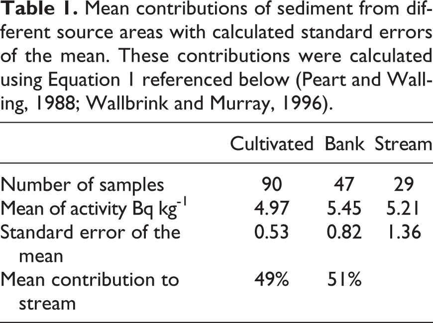
Using Equation 1 in this study, Malone (2017) found that 49% of sediment came from fields managed under the broad term of no-till (meaning a wide variety of terms that farmers use for no-till) and 51% came from eroding channel banks. To determine these percentages, the mean values of cesium-137 analysis were input into a simple mixing model represented in Equation 1 (Peart and Walling, 1988; Wallbrink and Murray, 1996), which allows for comparison of radioactivity among the samples. The percentage of cultivated source materials (Cs) is calculated by taking the difference between the stream sediment (Pr = 5.21) and bank soil (Pb = 5.45). This number is divided by the difference between the cultivated soil (Ps = 4.97) and the bank soil (Pb = 5.45). Equation 1 for the model is as follows:

where
Cs = contribution from cultivated surface sources (%);
Pr = mean value of property for stream bottom sediment [Bq kg-1];
Ps = mean value of property for cultivated soil [Bq kg-1]; and
Pb = mean value of property for bank material [Bq kg-1]
97) and the bank soil (Pb = 5.45).
Figure 2 shows the locations where cesium-137 samples were collected throughout the watershed. Samples were collected from three transects on the upper, middle, and toeslope positions of hillsides above channel banks and from stream bottom sediments and channel banks alongside streams throughout the watershed.
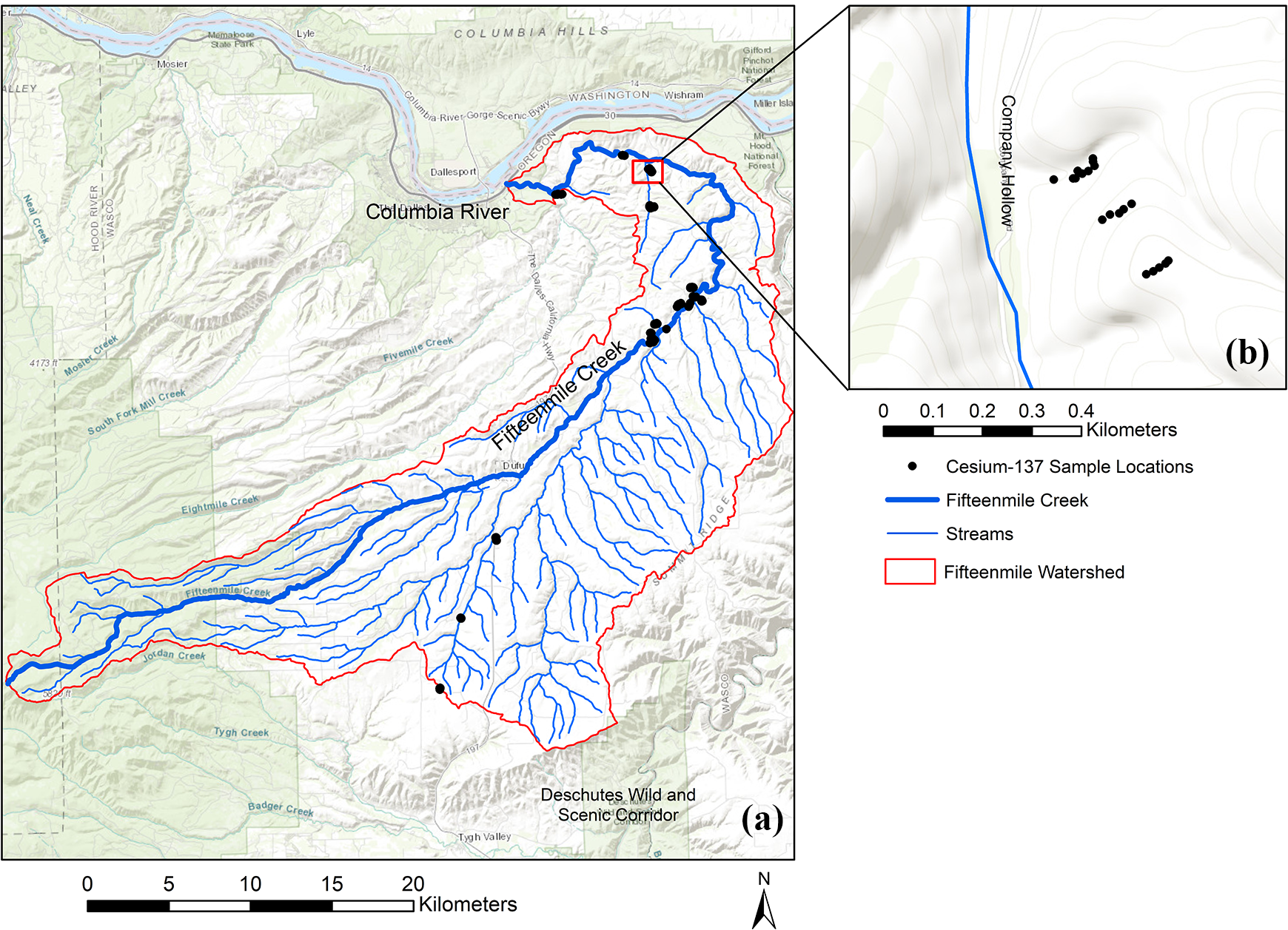
Locations of cesium-137 sampling. (a) The distribution of sampling locations, with the Fifteenmile Watershed outlined. (b) An example of the sampling scheme.
While we feel confident in the results of the study conducted by Malone (2017), we do wish to address the limitations of cesium-137 studies for this paper. Although cesium-137 has been used for a number of sediment studies in watersheds (e.g., Nagle and Ritchie, 2003; Olley et al., 2013; Wallbrink, 2004) it does have limitations. The first of these limitations is the inherent assumption that the cesium-137 concentration in each sediment source area is normally distributed over the landscape. We felt safe in applying this assumption because the soil in each of the Fifteenmile Watershed source areas (e.g., agricultural fields, channel banks, and sediment beds) followed predicted patterns of cesium-137 deposition summarized by Zapata (2003). For example, Zapata (2003) indicates that in locations where cesium is normally distributed, the landscape positions where the cesium-137 inventories are smaller are interpreted as eroded and the positions where they are greater are interpreted as deposition sinks (see Fulajtar et al., 2017; Zapata, 2003). The concentration of cesium-137 in the Fifteenmile Watershed followed this pattern. The actively eroded surface (agricultural fields) had the least amount of cesium-137 (cultivated mean of 4.97 Bq kg-1) due to erosion from agricultural practices and naturally occurring processes, such as wind and water erosion, while the channel banks (5.45 Bq kg-1) and streams (5.21 Bq kg-1) had higher concentration levels because of ongoing erosion and downward migration over time. The second limitation of cesium-137 studies is that watersheds are often characterized by a small number of samples (e.g., <25) (Olley et al., 2013). In the cesium-137 study on the Fifteenmile Watershed, 166 samples were collected, a number large enough to produce statistically reliable results. Finally, the third limitation of cesium-137 studies is that it assumes that the researcher has accounted for all sources of sediment in the model. While other sources of sediment could be present in the watershed, previous erosion studies in the Fifteenmile Watershed, such as the aforementioned RBS studies and pebble counts, indicated that the sources of sediment in the Fifteemile Watershed portion of Wasco County were different from sediment in other locations (e.g., upstream sediment from recreational forestland, and roads in the watershed) (Jessup, 2016).
2 Interviews and surveys
In order to determine why 49% of the sediment in the watershed was derived from fields in no-till agriculture, we sent surveys to, and conducted interviews with, farmers who have been farming in the study area in the range of three to five decades. Ten farmers, who represent about one-third of the farmers in the watershed, responded to surveys with varying levels of detail provided about past farm practices and known modifications to streams. These surveys were distributed by the local Soil and Water Conservation District (SWCD) by mail and were useful for determining what agricultural practices could be resulting in sediment erosion in the watershed. We asked the following questions: How long has your property been in no-till or direct seed? Please specify which form of agriculture was used, starting and end dates, and locations. What other forms of agriculture have been used on the property in the past (e.g., straw/mulch till, conventional till, etc.)? Please indicate years if known and locations. What are the plow depths on the property and what type of equipment is used on the property? Please indicate the size of equipment and plows used. Did any major erosion occur on your properties from wind, rain, overland flow or gullies or rills? If known, please indicate the years when erosion occurred on a frequent basis and/or years of erosional events that were more severe. Please indicate locations.
The level of detail supplied in the surveys varied, with most farmers noting general trends of land use, as opposed to specific locations of management practices. However, more detailed information was provided by the informal semi-structured interviews that we conducted with six farmers who, cumulatively, are amongst the highest recipients of subsidy and conservation payments in the watershed related to no-till practices (EWG, 2017a; EWG, 2017b). While we acknowledge that this is a small sample number of interviews, these farmers have managed the majority 1 of the Fifteenmile Watershed for at least three to five decades and were an appropriate sample size for this case study. During these interviews, we asked specific questions about no-till practices that allowed us to determine how no-till had changed sediment runoff in the watershed. We conducted interviews with farmers during their time working in the field, and interviews ranged from 1–3 h at a time, depending on the availability of the farmer. We also conducted interviews with nine other key informants, including two NRCS employees, one DEQ employee, two ODA employees, one Oregon Department of Fish and Wildlife employee, one extension agent, and two local SWCD employees. Interviews with these key informants took place in office settings or over the phone and usually lasted 1–2 h. Each key informant was interviewed at least once, and NRCS employees were interviewed over the course of at least two sessions to verify specific details about erosion estimates.
The specific interview questions, along with the purpose for asking the questions, are located in Appendix B. In some instances, we asked the same question to different types of key informants (e.g., farmers and agency members) in order to determine what knowledge discrepancies exist in the watershed. For example, we posed the same question about the definition of no-till to all of the key informants to determine whether there was variability in its definition. Asking the same question to different key informants also allowed us to identify knowledge gaps in the community about sources of sediment.
Interviews with farmers and other key informants were recorded (with their permission) and then transcribed using a transcription service. We then coded the transcribed interviews for specific themes that helped us to determine whether there were variations in no-till practices and to try to understand what sources of sediment may be unaccounted for in the watershed (such as farmland not managed with no-till conservation methods). We specifically coded interviews for the following themes: Variability in the use of equipment, no-tillage practices, and other forms of tillage practices (e.g., what type of equipment is used for no-till, years that no-till was practiced, how no-till is practiced). Agency oversight of no-till practices to determine whether no-till practices were monitored for consistent practices. Definitions of no-till and other conservation practices to understand how each key informant or farmer interprets/defines no-till and conservation techniques used in the watershed.
The combination of these interviews and the cesium-137 analysis provided information that revealed what sources of sediment erosion were overlooked and underestimated in previous erosion studies in the watershed. This approach also allowed us to explain why almost half of sediment was derived from soil in fields managed under the loose term of no-till.
IV Results and discussion
1 Variations in no-till practices influence sediment runoff
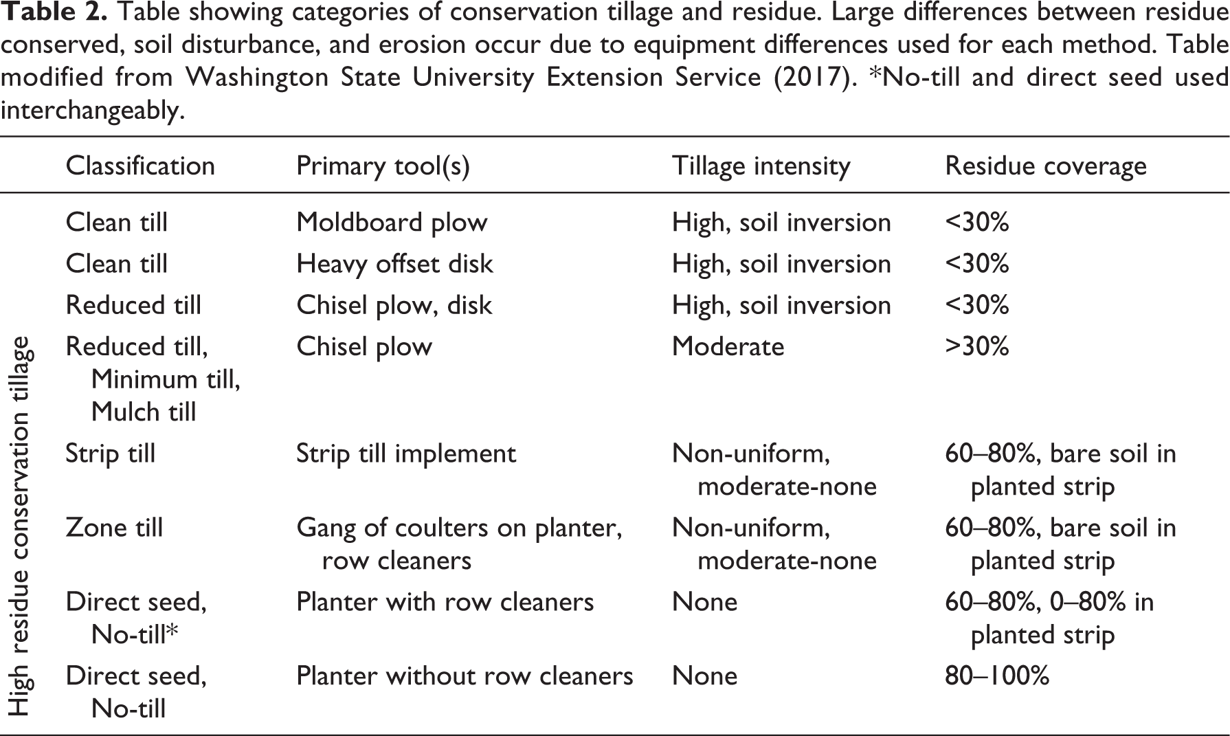
Our surveys and interviews with farmers revealed that variations in the way no-till currently is practiced has an effect on sediment runoff into streams, and explains why 49% of sediment is still derived from agricultural fields in the watershed under no-till management. After a major flood in 1996, many farmers upgraded their equipment to various types of direct seed equipment that was authorized under government contracts that they had access to during the late 1990s and early 2000s. According to the six farmers interviewed and one local NRCS employee, as long as farmers purchased equipment that met the criteria for direct seed, then farmers who enrolled in conservation contracts and converted their land to no-till were considered to be in compliance with the amount of disturbance allowed and would receive payments for the duration of their contracts (usually 3–5 years). However, the transition to no-till took place over approximately 8 years and the six farmers we interviewed indicated that farmers in the watershed gradually converted acreage from conventional tillage to some sort of reduced tillage or what is often referred to as minimum tillage (see Table 2). True no-till practices, as defined by the NRCS office (NRCS, 2006), have a soil tillage intensity rating (STIR) of <10, which translates to approximately 15% disturbance of row width during planting. However, one NRCS employee indicated that equipment that has been accepted for contracts for enrolling into no-till programs in the watershed has included equipment that contains hoe/chisel openers and drills, which can cause as much as 30% disturbance to row widths during planting and is in the moderate range of tillage intensity (NRCS, 2006). The variation in equipment that farmers used in the watershed was reflected in the interviews with farmers we conducted. Four of the six farmer interviewees indicated that they use air drills and knives with their direct seed equipment, keeping row disturbance closer to 15%. The other two farmers indicated that they use other types of hoe openers that fall within the acceptable range of disturbance but are not true no-till hoes. None of the farmers who submitted surveys indicated the specific type of equipment they used.
Table showing categories of conservation tillage and residue. Large differences between residue conserved, soil disturbance, and erosion occur due to equipment differences used for each method. Table modified from Washington State University Extension Service (2017). *No-till and direct seed used interchangeably.
2 Gaps in agency oversight
We also noted variability in the oversight of no-till implementation in the watershed. According to one NRCS employee, one DEQ employee, and all farmers we interviewed, initially, when farmers signed up for no-till contracts, some farms (number not indicated by interviewees) were checked for compliance with this STIR value on their properties. However, limited resources and labor restricted the government’s ability to confirm that the amount of disturbance occurring across the watershed actually met the STIR value criteria. Further, since most farms are now out of contract for these conversions to no-till, and overseeing agencies (ODA and NRCS) assume that most farmers have direct seed equipment, the actual percentage of disturbance on each tract of land is unknown on a watershed scale, leading to confusion over what type of no-till practices are occurring.
The number of farmers practicing true direct seed as opposed to some other form of conservation tillage is extremely important, because of the effect it can have on surface erosion in cultivated soils otherwise assumed to be minimally disturbed. In 2015, NRCS used the Revised Universal Soil Loss Equation (RUSLE) 2 to determine how much sediment was eroded in the Fifteenmile Watershed and uses it as its current estimate for erosion in the Fifteenmile Watershed (NRCS, 2015) (Table 3). The NRCS assumes that 328 km2 in the watershed is managed with no-till or true direct seed techniques, which amounts to approximately 25,000 metric tons of soil erosion per year, and is more than an order of magnitude less than the amount of soil eroded under conservation tillage or conventional tillage (Table 3). However, once variations in disturbance are factored in (e.g., the variations in practice we determined from our interviews with six farmers), the amount of erosion occurring increases substantially, as shown in Table 4. The table shows a range of possibilities for erosion given the variability of farmers’ responses during interviews. If it is assumed that approximately 5% of users still practice conventional tillage (the mean value of those left over if it is assumed that between the 93–96% of users practice some form of no-till), then 156,200 metric tons of soil are eroded each year. This is much higher than the estimate shown in Table 3 if all users practice no-till/direct seed as technically defined.
Differences between erosion rates based on type of tillage used. Erosion rates were calculated by NRCS in Wasco County using RUSLE 2. The amount of metric tons of soil lost per year assumes that there are 328 km2 of cultivated land in the watershed.

Differences between erosion rates based on variations in the range of users of a particular method. The results are compiled from six farmer interview responses (n = 6). These six farmers represent the majority of ownership in the watershed, and 4/6 farmers (or 2/3) practice no-till and direct seed, accounting for the 63% of no-till/direct seed users.
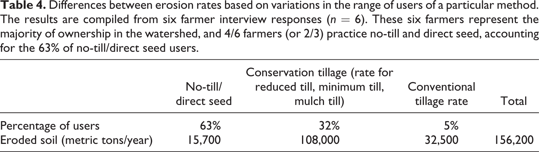
If the information supplied during the six informal interviews is applied to the watershed as a whole—a reasonable assumption given that the six farmers interviewed manage the majority of the watershed—and four out of six people (or 63%) practice direct seed as it is technically defined, then approximately 15,700 metric tons of soil erosion per year can be attributed to the current version of no-till practices. The remaining 32% of users practicing some form of conservation tillage produces almost 108,000 metric tons of soil erosion, and those still practicing conventional tillage produce over 32,500 metric tons of soil erosion, with a total amount of over 156,200 metric tons of soil eroded per year. While this estimate is below what would be eroded if everyone practiced conventional till (649,000 metric tons of soil per year), it is still significantly higher than the estimated 25,000 metric tons of soil eroded per year were all farmers practicing true direct seed, and is likely a reason that higher sediment loads in streams persist.
3 Definitions of no-till vary
Beyond interviews with farmers and NRCS, interviews with other agencies (ODA, DEQ, local SWCD) and an extension agent with knowledge of the region corroborated much of the variability that is occurring over definitions of no-till in the watershed. One DEQ agency employee stated in an interview that every farmer has his own definition for what constitutes no-till and that this definition varies between farmers, with most farmers considering some form of high residue tillage (e.g., reduced till, strip till, mulch till, and zone till; see Table 2) as no-till. The DEQ agency employee also indicated that many farmers are able to practice no-till or direct seed that meet the requirements for maximum residues and minimal disturbance in two or three of their crop rotations, but also might have to incorporate a form of conservation tillage another year due to field conditions or other environmental factors that do not permit adherence to true no-till practices. For this reason, many farmers use the term “no-till” interchangeably with conservation tillage, even though they may not be consistently meeting the requirements of true no-till or direct seed practices. All farmers that we interviewed indicated that these variations occur as well.
One extension agent also indicated that a small number of farmers (exact number unknown) in the county and the Fifteenmile Watershed had returned at least part of their land back into some form of conventional tillage or minimum tillage after practicing no-till. These conversions were due to a variety of issues related to difficulties with herbicide resistance, difficulties managing crop stubble, and changes in weather patterns that made predicting farming difficult. The extension agent explained that under conventional tillage, farmers could “farm by the calendar,” meaning that there was a set schedule and time by which preparatory work and ongoing management of farming occurred. With no-till, on the other hand, the extension agents and six farmers noted that even though they were getting better at no-till practices, they were still trying to figure out the best timing for some practices. This trial-and-error approach has sometimes proven difficult, especially during times when changing weather patterns have been prevalent in the region and the state. The return to conventional plowing methods from no-till due to herbicide resistance has been observed in other studies (e.g., Bain et al., 2017; Neuman and Pollack, 2010) and this includes plowing fields to eradicate resistant weeds, thereby reducing the use of minimum and no-till farming. Three farmers even raised climate change as a contributing factor to their difficulties with management, but the majority indicated that conditions under no-till were better overall than when they practiced conventional tillage or other forms of conservation tillage as distinguished from their current definition of no-till practice. However, all six farmers interviewed indicated that the implementation of no-till, varied from farm to farm and farmer to farmer.
4 Faulty knowledge systems lead to inaccurate sources of information
In conducting this study, we believe that inaccurate erosion estimates in the watershed, as well as overlooked sources of sediment were likely the result of persistent, yet fallible, forms of what Nerbonne and Lentz (2003) refer to as “knowledge exchanges and systems” that are common to many watersheds where environmental management occurs. These knowledge systems are embedded in knowledge communities, in which a dynamic network of actors constructs knowledge through the processes of exchanging ideas (Raedeke and Rikoon, 1997). These systems can be helpful in many watersheds, especially where multiple parties are interested in implementing more sustainable management.
However, as Fazey et al. (2013) indicate, the accumulation of knowledge and information is not enough: the effectiveness of environmental management depends greatly on how knowledge is exchanged, with whom it is exchanged, and how it is used (Cash et al., 2003; Francis and Goodman, 2010; Pullin and Knight 2001). We determined in our interviews that no-till was widely supported in the community of the Fifteenmile Watershed, but different practices and variations in its implementations were also common, and no knowledge about how it was practiced from farmer to farmer was available, as indicated by all interviewees. Our survey and interviews were the first studies to actually use social data in the watershed to determine how much land was under no-till, while the RUSLE 2 model used by NRCS was only based on the number of square meters in the watershed, and the percentage of square meters that was assumed to be managed under no-till systems (95%).
At the time of this study, the only challenges to the knowledge system that no-till was working were the ongoing and continued Total Maximum Daily Load exceedances and the RBS and pebble studies that indicated that no-till was actually not improving sediment runoff. Because these data were contradictory to the narrative that no-till had worked, the Fifeenmile Watershed Council (comprised of various farmers in the watershed) requested scientific proof (e.g., the RUSLE 2 model) that showed no-till was effective in the watershed.
The request for scientific narratives and proof that sustainable practices are working in agricultural watersheds with strong environmental management is common to many watersheds (Krzywoszynska, 2019). For example, Krzywoszynska (2019) argues that farmers often use scientific narratives about the general benefits of sustainable soil management practices to justify their decisions, which also relieves them of the burden of providing quantifiable “proof” about these practices. She writes that in these scenarios scientists and researchers become the primary authority on what sustainable soil management methods work, while paradoxically the farmers in the watershed know it is difficult to prove that their sustainable practices are working. As a result, farmers often request that scientists study the effects of sustainable soil management (in our case no-till) in order “legitimise their commitment to it through the scientific method, which is seen as objective and universal and therefore authoritative” (Krzywoszynska, 2019).
Much of this scenario was tangible in our study on the Fifteenmile Watershed. For example, an interagency council (partially comprised of farmers) in the watershed asked us, as researchers, to scientifically determine where excess sediment in the watershed was coming from in the watershed, and to support the findings of the RUSLE 2 research model that NRCS used. However, upon reviewing the results of the cesium-137 study (which were included in the larger study on the Fifteenmile Watershed), and the findings of the pebble count and RBS studies conducted by DEQ and USFS (Jessup, 2016), we determined that there was enough physical data to ascertain that sediment conditions in the watershed were not improving, and instead sought to determine what anthropogenic activity was likely contributing to sediment runoff issues. In doing so, our findings were controversial with the NRCS employees in the watershed, because they expressed concern that our analysis should be mostly based on physical analysis as opposed to the social data we collected from our interviews and surveys. Unfortunately, this reflects a trend in many studies on soil erosion, where studies that take into account the anthropogenic factors relating to soil degradation are not looked at favorably, and “even in studies on basic soil formation, human intervention has rarely featured as intrinsic to the story” (Engel-Di Mauro, 2014).
After we shared the results of the study with members of the watershed in 2018, it was unclear as to whether or not any modifications to no-till practices would occur because the knowledge system of the success of no-till had been widely promoted. As researchers at independent institutions outside of the Fifteenmile Watershed, we were unlikely to change everyone’s practices. However, as a result of this research, agency employees at the ODA are trying to determine which properties in the watershed may still be contributing runoff to the streams. DEQ is also conducting further studies on sediment runoff, and is attempting to gather information that would give more specific data about practices people use in their fields. Our research team and the DEQ also tried to compare our data with NRCS over the duration of this research, but NRCS would not share with our research team or the DEQ what specific portions of land are assumed to be under no-till production that was used in the RUSLE 2 model, citing specific laws related to farmer protection. This also contributes to ongoing gaps in the knowledge system that make it difficult to determine who and what practices are contributing to sediment exceedances in the watershed.
These barriers to knowledge and information exchange between agencies working in watershed are common in the United States and are often the result of greater overarching policies that allow one agency to monitor the conditions of a watershed, while not allowing that same agency to practice any enforcement (Doyle et al., 2013; Harrison, 2008). Further, in the Fifteenmile Watershed, despite the many agencies involved, no single agency has the capacity to check that farmers in the watershed are actually practicing no-till as prescribed. This problem is, again, representative of larger policy issues, as states have reported having insufficient funds, inadequate monitoring programs, and limited staff to collect and analyze sediment data related to water quality (Government Accountability Office, 2011).
Besides these challenges, our research also indicates that barriers to sharing data arise from what Nerbonne and Lentz (2003) refer to as “inherent power dynamics.” At present, the belief that no-till systems solved the majority of sediment runoff in the watershed is strong, partially because it took so much labor and money to get no-till implemented in the first place. According to all of the key informants and the farmers we interviewed, the transition to no-till was widely supported by frequent educational meetings and was sponsored by the local SWCD, ODA, and grant programs associated with US Farm Bills during the late 1990s and early 2000s. These efforts amounted to almost USD 26 million (NRCS personal communication). As farmers managed to implement no-till into their practices, it generated the belief and knowledge systems that no-till was also successfully eliminating most of the watershed’s sediment exceedances, and the agency members who were most involved in promoting no-till (e.g., NRCS, ODA, local SWCD) also expressed that the conditions in the Fifteenmile Watershed must have improved because of the large sums of money and resources that went into its implementation. These comments reflect a vested interest in no-till succeeding in the watershed, as so much capital and educational resources went into promoting no-till. In addition, three agency members (in charge of oversight of no-till) indicated that they were reluctant to check what the farmers were actually practicing in the watershed, because they felt that some amount of effort on the farmer’s part was better than no effort at all. Each of these interviewees indicated that they wanted to see no-till succeed despite the known issues in its variability. These issues further complicate the implementation of no-till, as each individual actor is working within a hierarchy of power dynamics at play in the watershed. As Nerbonne and Lentz (2003) argue, the individual farmer makes management choices while influenced by local farmer networks, which in turn are affected by the larger social, political, and economic system instituted by managing agencies in the watershed. As such, the narrative surrounding the success of no-till has become a societal norm in the watershed, and it is not easily challenged because of the inherent power dynamics that make challenging its success unpopular. Although our research team highlighted a source of sediment that had not been considered before, we expect slow change to occur, as “social movements are most often the result of both institutional and extra-institutional action aimed at challenging an accepted societal norm” (Nerbonne and Lentz, 2003).
V Conclusions
In this study, we used a mixed-methods approach, involving the use of cesium-137 and interviews and surveys to determine how estimates of erosion overlooked both physical data sources and social data sources that explained exceedances of sediment in a watershed managed by no-till agriculture. In particular, this study highlighted the need for social engagement and analysis of farming communities for sediment issues in watersheds using conservation practices associated with no-till. Using this approach, we found that there are large disparities between the erosion that is currently estimated in the Fifteenmile Watershed with the RUSLE2 model and that variations in no-till practices are contributing to the 49% of sediment sources that are eroding in the watershed.
While our study illuminated the many issues with the variations in no-till management, we wish to clarify that this study’s findings do not indicate that no-till farming, if practiced as defined by the NRCS, causes additional problems with erosion of sediment. It has been well documented that no-till practices reduce erosion rates from dryland agricultural watersheds (e.g., Fernandez-Cornejo et al. 2013; Fu et al., 2006; Schreiber et al., 2001). Rather, this study finds that the amount of disturbance and amount of erosion varies widely by the way no-till is practiced in the watershed, and that more effort should be put into finding out what practices are causing different amounts of erosion in the watershed through social engagement and analysis of knowledge systems alongside physical data analysis. This could be achieved by a more detailed engagement with farmers in the community to assess how much disturbance their machinery causes to the landscape and working on practices that could improve and minimize erosion on the landscape, but also on collaboratively working on knowledge systems between researchers, farmers, and managing agencies, to determine the best course of action for conservation management systems. This would be beneficial for the entire community, as many of the farmers involved in this study expressed their pride in being involved in conservation programs and were genuinely interested and engaged in practices that would improve stream conditions.
Further, it should also be noted that the farmers in this study and throughout the watershed were encouraged to participate in no-till through a variety of government programs and contracts that were made available to them. The information supplied to them by NRCS about no-till and how much it improves farming conditions and what their practices should be, should have significantly improved stream quality, but has not for the following reasons: 1) conservation programs associated with farm bills often have loosely defined requirements for how to improve environmental conditions, 2) lack of resources (both in labor and time) available to government employees who are instructing farmers how to use no-till limit the amount of critical evaluation of how effectively a given conservation is being practiced, and 3) continued misinformation provided to farmers and the community perpetuate the idea that environmental conditions are improving when they are not. This last point is most damaging and frustrating for farmers that are engaged in conservation practices as, on the one hand, they are encouraged to practice a method that is said to improve their environment, while on the other, they are regulated when the methods they think they are using correctly do not work as intended. When one makes these observations, it is clear that the persistence of sediment in the watershed is more a reflection of inadequate policies and instruction derived from an institutional level than any one practice that a farmer may be practicing on his property, and strategies to identify how conservation methods could be improved should be discussed.
Supplemental material
Supplemental Material, Appendix_A - A physical and social analysis of how variations in no-till conservation practices lead to inaccurate sediment runoff estimations in agricultural watersheds
Supplemental Material, Appendix_A for A physical and social analysis of how variations in no-till conservation practices lead to inaccurate sediment runoff estimations in agricultural watersheds by Melanie Malone and Viktor Polyakov in Progress in Physical Geography: Earth and Environment
Supplemental material
Supplemental Material, Appendix_B - A physical and social analysis of how variations in no-till conservation practices lead to inaccurate sediment runoff estimations in agricultural watersheds
Supplemental Material, Appendix_B for A physical and social analysis of how variations in no-till conservation practices lead to inaccurate sediment runoff estimations in agricultural watersheds by Melanie Malone and Viktor Polyakov in Progress in Physical Geography: Earth and Environment
Footnotes
Declaration of conflicting interests
The author(s) declared no potential conflicts of interest with respect to the research, authorship, and/or publication of this article.
Funding
The author(s) disclosed receipt of the following financial support for the research, authorship, and/or publication of this article: This material is based upon work supported by National Science Foundation IGERT Grant #0966376: "Sustaining Ecosystem Services to Support Rapidly Urbanizing Areas. Any opinions, findings, and conclusions or recommendations expressed in this material are those of the authors and do not necessarily reflect the views of the National Science Foundation.
Supplemental material
Supplemental material for this article is available online.
Note
References
Supplementary Material
Please find the following supplemental material available below.
For Open Access articles published under a Creative Commons License, all supplemental material carries the same license as the article it is associated with.
For non-Open Access articles published, all supplemental material carries a non-exclusive license, and permission requests for re-use of supplemental material or any part of supplemental material shall be sent directly to the copyright owner as specified in the copyright notice associated with the article.