



Abstract
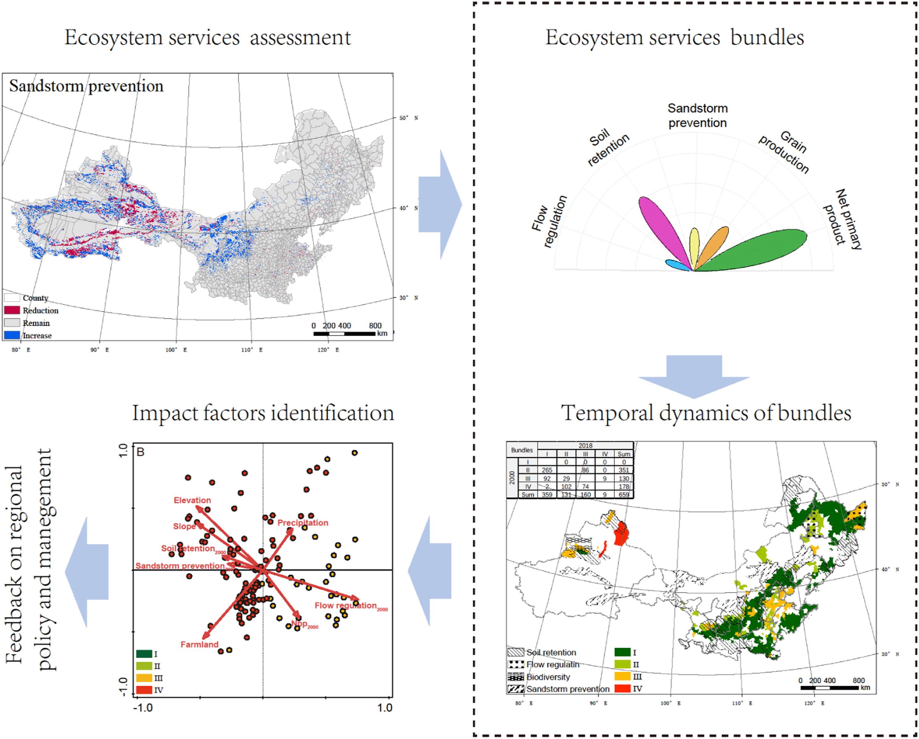
Understanding the spatiotemporal distribution of multiple ecosystem services (ESs) and their complex internal relationships is crucial for regional collaborative sustainable development. The lack of research on the temporal dynamics of multiple ESs and their internal relationships limits the effective management of ecosystem services. Based on spatial patterns and temporal dynamics, we mapped the changes in five key ESs and assessed the internal relationships over 1324 counties in northern China from 2000 to 2018. The spatial differences in ES relationships were clustered into four distinct ES bundles, and we quantified the driving force of spatiotemporal pattern changes in ES bundles. Our results showed that the relationships among ESs changed with time. From 2000 to 2018, the ES bundle pattern changed mainly in the east. The relationship of some counties changed from the trade-off between provisioning and regulating ESs to synergy, while the others changed from low synergy to high synergy. The identification of impact factors of the service cluster pattern showed that the dominant force factor for improving ecosystem service synergy in northern China is the initial condition, and the contribution of human land management and economic development is approximately 11.0% in the high-level synergy bundles and greater than 20.0% in other bundles. By addressing the spatiotemporal change in ES bundles, we clearly identified the direction and strength of the ES response to ecosystem management and provided a basis for large-scale land management evaluation and effective information for future policy making in northern China and other areas with similar natural conditions.
Keywords
Highlights
(1) Spatiotemporal characteristics of ecosystem services are crucial for local sustainable development. (2) Dynamic relationships among key ecosystem services have been assessed at county scale in northern China. (3) The relationship changed from trade-off to synergy in the east, while remained constant in the west. (4) Impact factors of spatiotemporal changes of ecosystem service bundle have been qualified.
I Introduction
Ecosystem services (ESs) are the conditions and processes through which natural ecosystems, and the species that make them up, sustain and fulfill human life (Daily, 1997). Compared to the growing demand for science regarding the need to manage multiple ESs, we still have relatively little understanding of the ecology behind the provision and variation in ESs (Bennett et al., 2009; Kremen and Ostfeld, 2005; Potschin and Haines-Young, 2011). As a vital role in bridging human society and with natural ecosystems (Mandishona and Knight, 2022; Peng et al., 2017; Wang et al., 2021), the internal relationships of ESs and their external driving patterns are complex (Bennett et al., 2009; Torralba et al., 2018; Wu, 2013). Synergy and trade-off are the typical features presented by ESs, of which the former is the inner way to maximize the benefits of ESs, and the latter plays an important role in the protection, restoration, and sustainable management of the ecosystem (Chen et al., 2020; Power et al., 2010; Raudsepp-Hearne et al., 2010; Zhao et al., 2022). To characterize the spatio-temporal dynamics of ESs trade-offs and synergies is the key to maintain regional sustainable development.
In the ecosystem, trade-offs and synergies usually coexist and interact on spatiotemporal scales between different types of ESs (Bennett et al., 2009; Qiu et al., 2021). ES trade-offs always occur between supporting, regulating, and provisioning services and are mainly due to the spatial and temporal heterogeneity of the supply and demand of ESs (Cord et al., 2017; Li et al., 2015; Peng et al., 2017). Correspondingly, synergistic patterns usually exist between ES types that do not require long-distance provision of natural resources (Li et al., 2021; Peng et al., 2017). For humans, nature can be viewed as a cluster of ESs, and it is suggested that an ES bundle approach could represent the magnitudes and detect the variation in relationships of ESs (Kareiva et al., 2007; Renard et al., 2015). Therefore, it should be a useful tool for revealing the inner relationship between ESs and improving ES management, especially in areas with multifunctional landscapes (Dittrich et al., 2017; Raudsepp-Hearne et al., 2010; Spake et al., 2017).
Numerous studies have studied the ESs bundles and their impact factors (Bi et al., 2021; Chen et al., 2020; Feng et al., 2017; Raudsepp-Hearne et al., 2010; Renard et al., 2015). Most cannot truly address these critical challenges because they have focused less on temporal perspectives (Kong et al., 2018; Nicholson et al., 2009), which are important for detecting the underlying causes and rate of change. Compared to the long-term impacts of climate and topography, human activities, particularly large-scale land management, can have a significant effect on the spatiotemporal pattern of ESs via land surface cover change (Daily et al., 2009; Smith et al., 2019; Turner et al., 2016) and further on the structure of bundles in a short time (Li et al., 2019; Yang et al., 2019). For a better understanding of the complex relations among ESs, the temporal dynamic between bundles and qualifying the contribution of impact factors not only help improve human well-being derived from ESs but are also conducive to sustainable ecosystem development (Balvanera et al., 2022; Buytaert et al., 2014; Renard et al., 2015).
Northern China is an important national ecological security shelter from the perspective of location and geographical conditions (Ouyang et al., 2006; Suo and Cao, 2021; Zhang et al., 2016). The region includes multiple ecosystems (e.g., forest, grassland, and bare land), topography types (e.g., plains, plateaus, and mountains), and climates (e.g., arid zone—cold steppe/desert, cold zone—dry winter—hot/warm/cold summer) (Liu, 2010). Under diverse natural conditions, ES relations also vary in time and space with large-scale land management (Koch et al., 2009; Qiu et al., 2018). Identifying the characteristics of internal ES changes is critical for subsequent land management and regional sustainable development (Kong et al., 2018; Renard et al., 2015). In this study, we identified patterns of interactions among four major ESs and net primary productivity (NPP) through ES bundle analysis in northern China from 2000 to 2018, with the following objectives: (1) identify spatial variation and interrelationships among different ESs; (2) clarify the characteristics of ES bundles and their changes from 2000 to 2018; and (3) explain the impact factors of the spatiotemporal variation in ES bundles. The results can not only improve the understanding of the complex interactions among ESs in the northern regions but also provide a reference for the management of large-scale land management.
II Methodology
2.1 Study area
The regions involved in this study include 14 provinces, covering the northern and north-western regions of China (Figure 1). This area is separated from the rest of China by the Kunlun–Qilian–Hengduan Mountains in the southwest and the Qinling–Huaihe River in the southeast. The terrain in northeast China is mainly plains, with plateaus and mountains. The climate is temperate monsoon, with an annual precipitation amount between 400 and 800 mm (Liu, 2010). Because rain is associated with temperature and the soil is fertile, this area is suitable for crop growth and has a high proportion of farmland. Northwest China is dominated by plateaus, basins, and mountains. The climate is arid, with precipitation decreasing from 400 mm in the east to less than 50 mm in the west. The land-use changes from grassland in the east to Gobi and dunes in the west. From 2000 to 2018, the obvious changes in land area in the study area involved forest land and farmland, in which forest land was mainly converted from farmland, while farmland was mainly converted from natural ecosystems (e.g., forest, grass, and wetland). Since the 1980s, large-scale land management has been implemented across the area, including the Three-North Shelter Forest Program, Beijing-Tianjin sandstorm source control, and Grain for Green Project. The main objectives of these projects are sandstorm prevention and control, dust reduction, and soil and water conservation (Gálos et al., 2013; Gao et al., 2008; Ma et al., 2022; Zhu et al., 2016). In addition, urbanization has intensified since 2000, while farmland must be maintained, which also requires considerable land management (Jiang and Lin, 2012; Yu, 2019). Study area and land-use pattern in 2018. The subgraph is the transformation of land use from 2000 to 2018.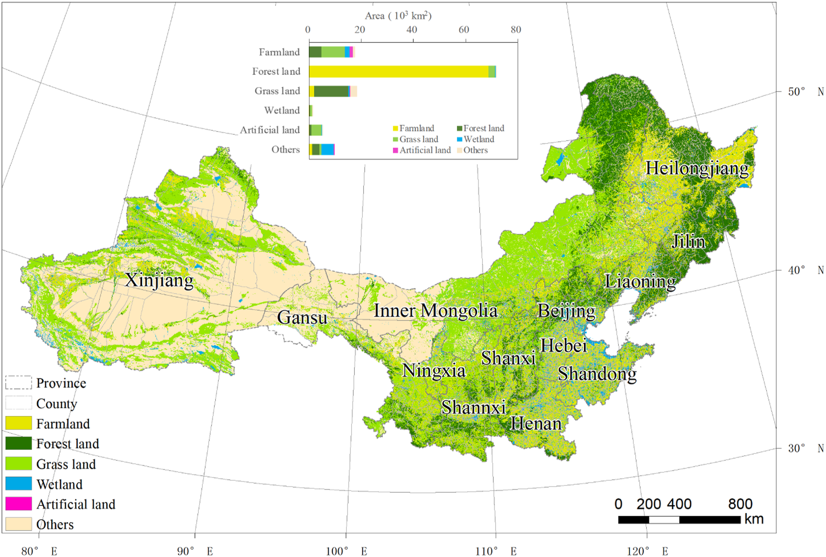
2.2 Data sources
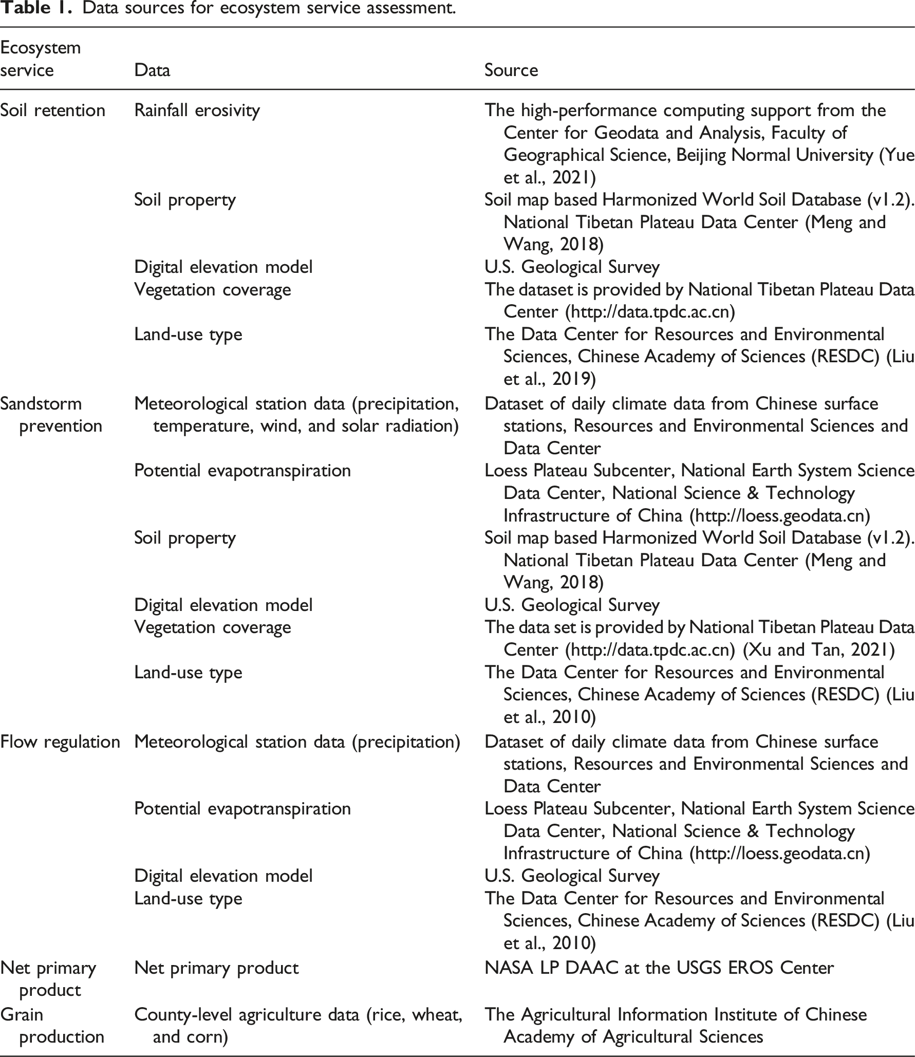
Data sources for ecosystem service assessment.
2.3 Ecosystem service assessment
According to the regional physical geographical characteristics and the objectives of ecosystem restoration, the following major ESs, including soil retention, sandstorm prevention, flow regulation, grain production, and NPP, were selected to represent the regulating and provisioning aspects.
2.3.1 Soil retention
The soil retention service is the difference between the potential soil erosion and the actual soil erosion of the ecosystem, which is described by the general soil loss equation (Renard et al., 1994):
2.3.2 Sandstorm prevention
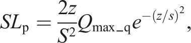
Considering the accuracy and historical comparability of the results, the availability of data, and the wide range of applications, we used the RWEQ to quantify sandstorm prevention services (Fryrear et al., 2000). The formulas are as follows:



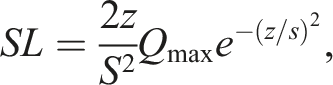

2.3.3 Flow regulation
The flow regulation service is defined as the proportion of runoff in the dry season to the annual flow, which is used to represent the regulation ability of different land covers on runoff. The larger the proportion of runoff in the dry season is, the stronger the regulation ability is. The formula is as follows: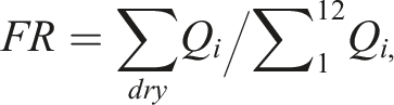
2.3.4 Major Grain production
We chose the total yield of major grain crops (rice, wheat, and corn) to indicate the grain production service for each county. The formula is as follows:
2.3.5 Net primary production (NPP)
As an important component of the surface carbon cycle, NPP directly reflects the productivity of vegetation communities under natural environmental conditions and represents the quality of terrestrial ecosystems, which could also indicate the influence of land management.
2.4 Correlation analysis and impact factors identification of ecosystem services
Based on the ArcGIS platform, the raster data were counted as the average to the county scale, and major grain production was counted as the total amount of each county. Finally, each type was standardized from 0 to 1 for the next analysis. Spearman analysis was used for correlation between services based on RStudio. The Spearman method was better for data compatibility and suitable for linear relationships (Chok, 2010). To avoid the interference caused by outlier data in large-scale data, the k-medoids method was used to cluster ESs at the county scale (Kong et al., 2018). Redundancy analysis (RDA) was used to identify the relationship between the main environmental impact factors in the changing region of ES bundles. Based on the understanding of previous studies of regional ESs (Li et al., 2021; Ouyang et al., 2006), the environmental factors mainly included the following categories: (1) ESs in 2000, namely, the initial value; (2) meteorological factors, for example, precipitation, temperature, wind, and evapotranspiration; (3) terrain factors, for example, elevation and slope; (4) land-use variation; and (5) socioeconomic factors, for example, population and gross domestic product (GDP).
III Results
3.1 Spatial changes and correlations of ecosystem services
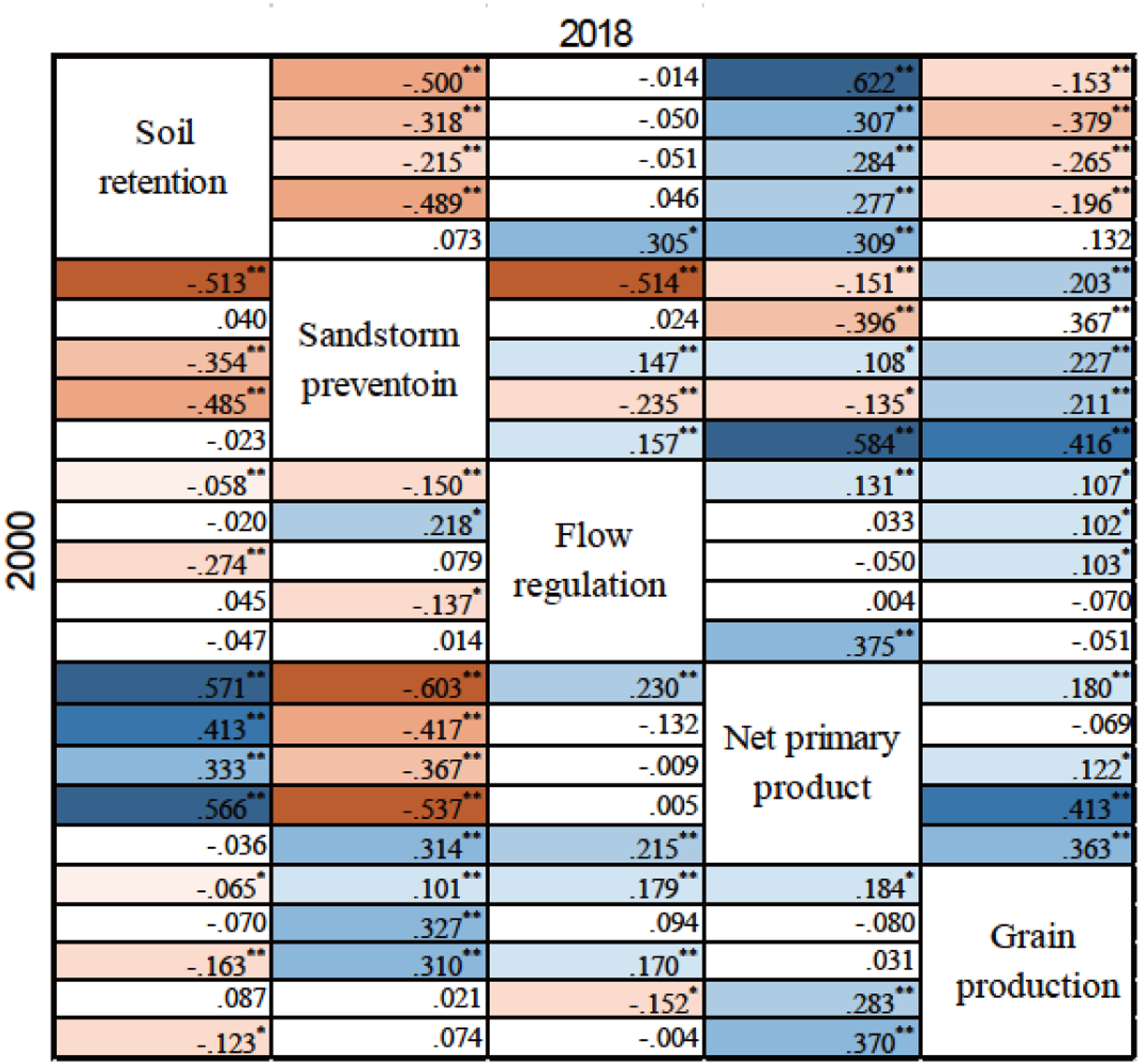
The spatial changes in ESs and NPP from 2000 to 2018 can be divided into three patterns (Figure 2). The first is soil retention and sandstorm prevention, which remained unchanged in most areas, increased locally, and decreased in fewer areas. The areas of soil retention increased significantly in the south-eastern margin of the Inner Mongolia Plateau, Loess Plateau, and Tian Shan Mountains, while sandstorm prevention services increased in the southern Yinshan Mountain, Tian Shan Mountain, and Junggar Basin. The second was NPP and major grain production, which were increasing in most regions. The areas with constant NPP were mainly located in the desert areas of Xinjiang and western Inner Mongolia, while the regions with constant major grain production were mainly located in Beijing–Tianjin–Hebei and other urban agglomerations. The last pattern was for flow regulating service, which presented a relatively balanced distribution of rising and falling. The areas with a reduction were mainly distributed in plains and basins in the northeast and northwest, while the areas of increase were mainly distributed in the plateau and mountain regions. At the county scale, seventy percent of ES correlations showed a synergistic trend from 2000 to 2018 (a significantly negative correlation weakened or a significantly positive correlation increased). In addition, sandstorm prevention with major grain production and NPP and soil retention with major grain production showed opposite trends, which all occurred between different types of ESs (Figure 3). Changes in ESs in northern China from 2000 to 2018. Spearman correlation matrix between ecosystem services. *p < 0.05; **p < 0.01. The bold font represents the entire area, and the successive regular font represents Bundles I, II, III, and IV. The blue and red backgrounds represent significant positive and negative correlations, respectively, and the depth represents the magnitude of the correlation.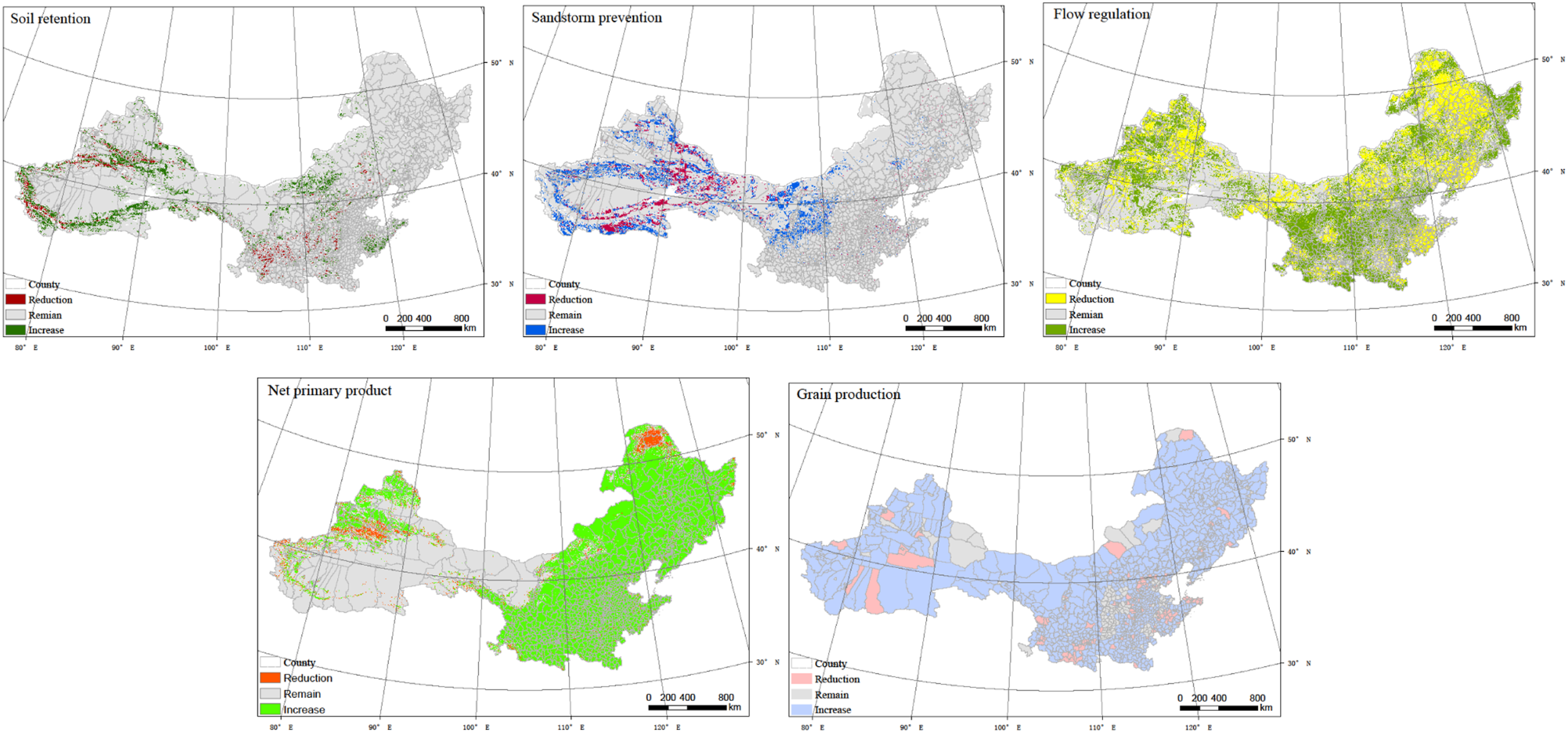
3.2 Spatial pattern of ecosystem bundles
There were four bundles clustered at the county level jointly in 2000 and 2018. Each bundle was composed of similar-magnitude ES structures that were spatially clustered (Figures 4(A) and (B), p < 0.05). According to the regional characteristics presented by ESs, the bundles could be named “I, synergy-high soil retention,” “II, synergy-high NPP,” “III, trade-off-high grain production,” and “IV, trade-off-high sandstorm prevention” (Figure 4 (C)). Bundle I has high soil retention service and the second highest vegetation coverage with an increasing county number, mainly distributed in the Qingling Mountain, the Greater Hinggan, the Lesser Hinggan, and the Changbai Mountain ranges. Bundle II has high vegetation coverage and relatively high soil retention and has expanded from the Northeast Plain and Jiaodong Peninsula in 2000 to the North China Plain and Gannan region in 2018. Bundle III had the highest major grain production service and flow regulation, mainly distributed in the North China Plain, Northeast Plain, and southern Shaanxi Plain. Bundle IV has the highest wind erosion prevention service and the lowest other services and is the most widely covered, mainly distributed in the Inner Mongolia, Ningxia, Gansu, and Xinjiang regions. Map of ecosystem service (ES) bundles between 2000 and 2018. (A) ES bundles in 2000; (B) ES bundles in 2018; (C) bundle type based on 2000 and 2018.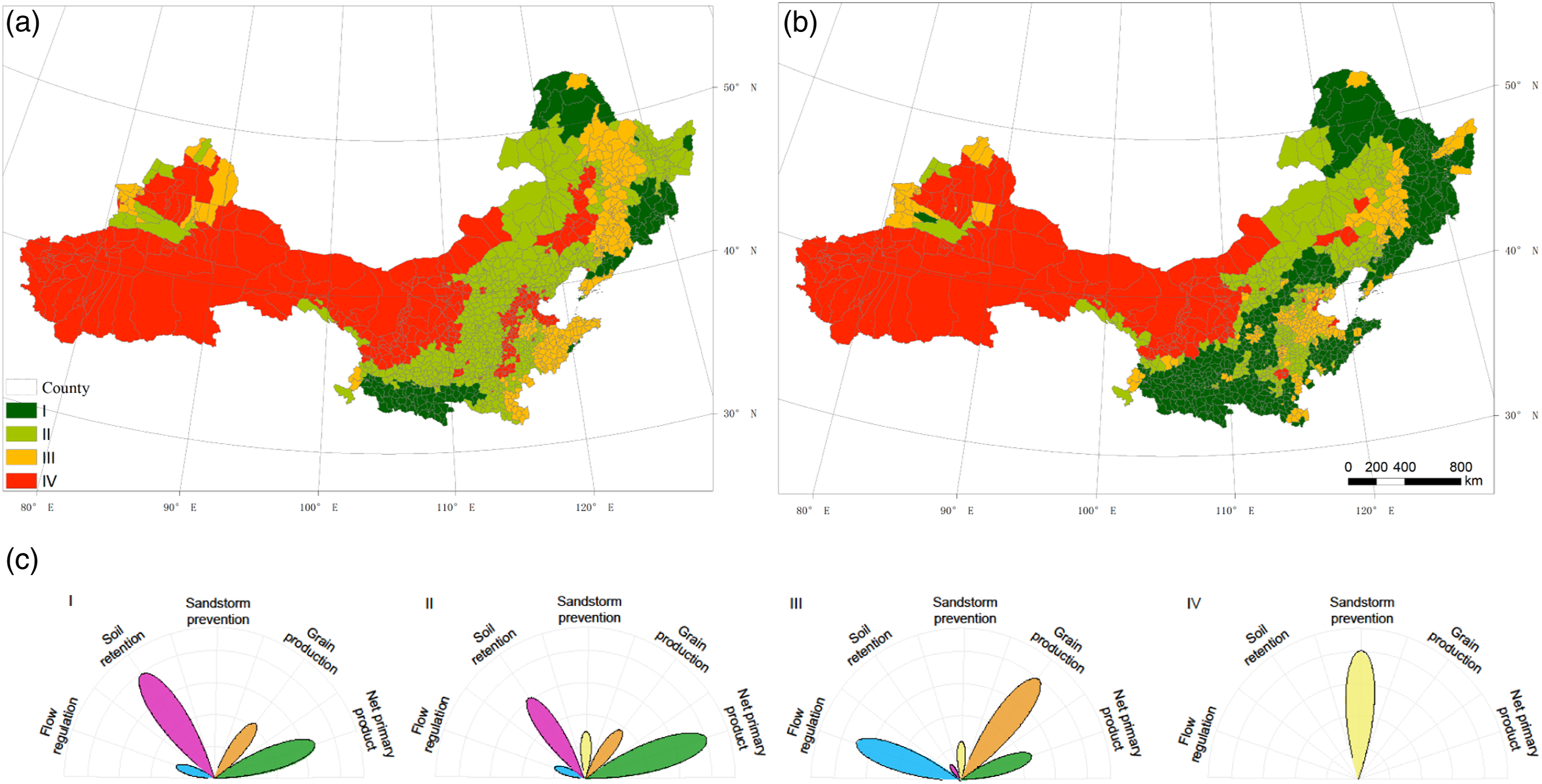
3.3 Changes and impact factors of ES bundles
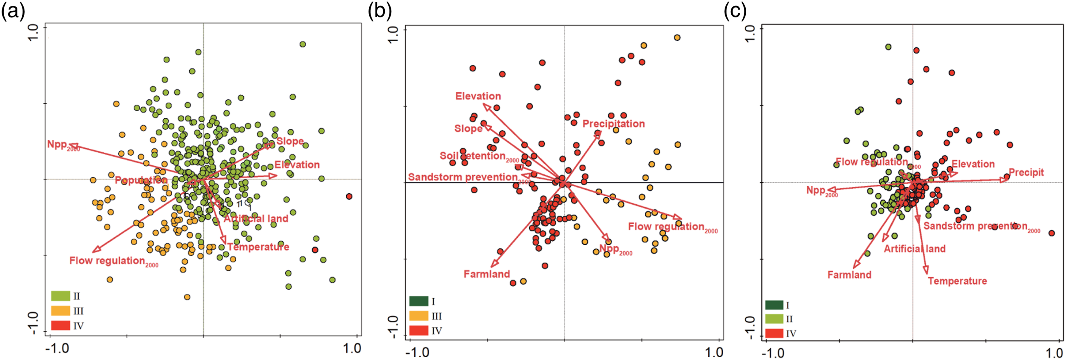
There were 659 counties with ES bundle changes, accounting for 49.7% of the total number, among which Bundle II transferred out the most (351 counties), followed by IV and II, while Bundle I didn’t transfer out (Figure 5). The area of variation accounted for 25.8% of the entire region, most of which occurred in the Northeast Plain, North Plain, and Loess Plateau. In the northern China, there are 27 key ecological function reserves, and the conservation objectives are soil retention, flow regulation, biodiversity, and sandstorm prevention. The changed ES bundles covered 253,400 km2 of soil conservation function reserves, and most counties in the region were converted to Bundle I, which indicated that soil conservation services were significantly improved. For flow regulation reserves, bundle changes occurred in an area of 87,957 km2, among which 68.04% of the regional flood regulation capacity was improved. The variation of sandstorm prevention and biodiversity function reserves were relatively stable, accounting for less than 15.0%, and all of them are transformed into more synergy bundles. In view of the limited counties transformed into IV, the redundancy analysis (RDA) focused on regions transformed into the other three bundles. The results (Figure 6) showed that the major factors that impact the spatial change in the synergy ecosystem bundles were initial ESs and NPP (accounting for 72.9% and 37.7%, respectively), of which NPP in 2000 contributed the most. For the first type (Figure 6(A)), meteorology and topography were the second most important contributing factors, accounting for 9.2% and 6.9%, respectively, while topography (24.1%) and human land-use management (23.3%) were the second most contributors for the second type (Figure 6(B)). Meteorology (36.5%) and initial ESs (29.1%), followed by human land-use management (20.5%), are the primary factors of the third type of change (Figure 6(C)). The main impact factors varied with the initial bundle type. To Bundle I, counties from Bundle II were mainly affected by topography and Bundle III was mainly affected by initial ESs. To Bundle II, counties from Bundle III were mainly affected by NPP and flow regulation and Bundle IV was affected by topography and land-use management. Bundle III was mainly derived from Bundles II and IV, which were subject to initial ESs and elevation, respectively. Changes in ES bundle classification from 2000 to 2018. Dark green, light green, orange, and red indicate other types that have changed to Bundles I, II, III, and IV, respectively. The subgraph is the number of transfer matrices for the counties of change from 2000 to 2018. The marked regions are the major ecological function reserves in northern China. RDA of ES bundle changes and significant impact factors (explanation: (A) (to Bundle I), 70.83%; (B) (to Bundle II), 68.02%; (C) (to Bundle III), 65.26%, p < 0.05).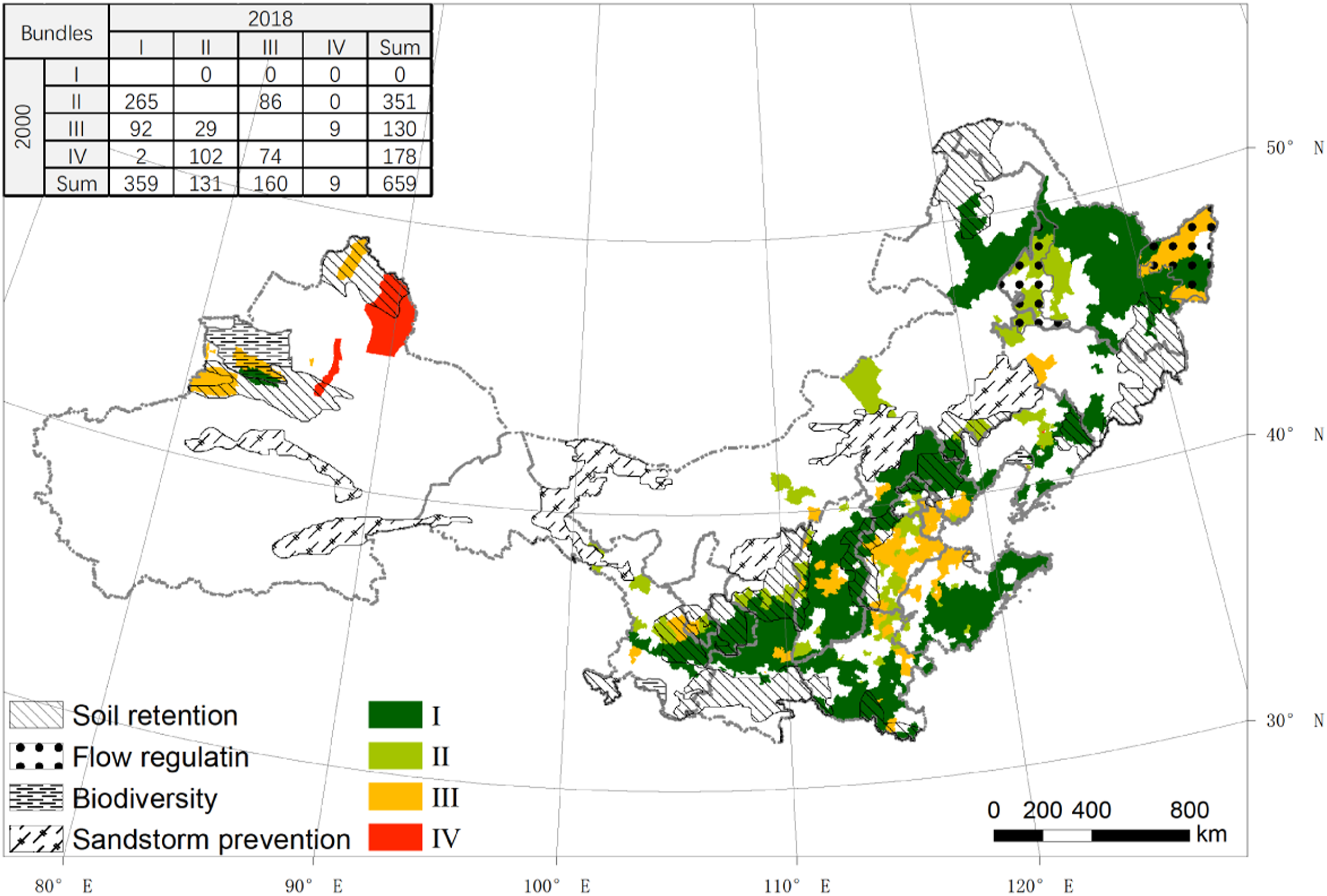
IV Discussion
4.1 Regional characteristics of ESs and correlations
The regional characteristics and correlations between ESs could reflect the relations of trade-offs and synergies (Renard et al., 2015), and comprehensive analysis is conducive to the management of ecosystems and the rational utilization of ESs (Kong et al., 2018; Peng et al., 2017). Our results showed that ESs had obvious differences in space, but an overall positive trend in temporal dynamics (Figure 2), and there were significant spatial differences in the trade-offs and synergies of ESs (Figure 3), which should be clarified for subsequent management.
The results of the assessment of key ESs in northern China are consistent with the spatial pattern of the National Ecological Function Zoning (MEE and CAS, 2015). The western region mainly focused on sandstorm prevention, the eastern mountainous region payed more attention to flow regulation and soil conservation, and the eastern plain region focused on grain production. From the perspective of the temporal dynamics of ESs and ESs bundle, the ecosystem in northern China is gradually entering a virtuous cycle under the protection of ecological policies and restoration projects. But there are still conflicts between ESs in some areas.
Normally, a higher NPP improves the overall regulating ESs (Song et al., 2015; Wei et al., 2017), but the significant stimulation was reflected only on soil retention and flow regulation in the northwest (Bundle III or IV). The reason could be attributed to the regional ecological restoration, for example Three-North Shelter Forest Program and Beijing–Tianjin sandstorm prevention Project, which increased NPP in the northwest, and made the regulating services present a generally positive correlation; while in the southeast, the NPP increased mainly to rely on farmland expansion, and the improvement on agricultural technology, combined with the regional fast urbanization, made only the dry season runoff and grain production increase significantly. Most provisioning services have a significant trade-off with regulating services (Peng et al., 2017), but there were only significant negative correlations between grain production and soil retention in this study. The improvement in the negative relationship was generally attributed to large-scale ecological restoration, for example, the Grain to Green and north-western afforestation projects, which significantly improved the regulating services in eco-fragile areas and offset the negative effects caused by farmland and urban area expansion. In addition, our results showed that the correlation between sandstorm prevention and other regulating services was not spatially synchronized; significant synergies occurred only in Bundles II and IV with flow regulation, while significant trade-off in Bundles II and III with soil retention. This result indicates that the synergistic effects of large-scale vegetation restoration in arid and semiarid regions may not be as good as expected, especially as water consumption may lead to regional trade-offs (Cao et al., 2020; Ma et al., 2022).
4.2 Characteristics and changes in ES bundles
Identifying ES bundles can reveal the differences and deficiencies in the natural conditions of ecosystems, and understanding the changes in ES bundles can help clarify the effectiveness of ecosystem management (Kong et al., 2018; Nelson et al., 2009). Our results of four distinct ES bundles and their changes in northern China well reflect the effects and shortcomings of previous relevant policies.
The results show that from 2000 to 2018, the spatial changes in ecosystem service relationships in northern China mainly occurred in the east, with the changes from trade-off to synergy in most regions, and from trade-off to synergy in local agriculture plains. The changes reflected both the difference in natural background and the spatial differentiation of human interference. From the perspective of regional policies and human activities in northern China, the farmland is mainly focused on the development of intensive agriculture and expanded in the southern foothill of Lesser Khingan Mountains and Songnen Plain (Zhang, 2016), which decline the local regulating services. The southeast region (especially around the agro-pastoral ecotone) is relied on the implementation of ecological afforestation and soil conservation project, which have been significantly improved (Huang et al., 2020), leading to the regional harmonious. For the western part of northern China, the natural condition is worse, and long-term land disturbance is desertification control, so the relationship between ecosystem services is relatively stable.
In 2000, Bundle IV, which takes sandstorm prevention as the absolute advantage, occupied most of the western region; while Bundle III dominated by grain production was the main type in the Northeast plain and the North Plain. By 2018, the spatial pattern of bundles has changed dramatically in the east. The middle-east was dominated by Bundles I and II, which were leading in regulating services and vegetation. The east has shifted to Bundle III with high grain production. From the perspective of bundle variation, the highest sandstorm prevention bundle (Bundle IV) was concentrated in the northwest due to the reforestation that began in the 1980s and has not changed in 18 years subject to harsh natural conditions (Li et al., 2013; Liu, 2010). Some counties with Bundle III (near the 400 mm precipitation line) changed to Bundles I and II in the east due to the afforestation under suitable hydrothermal conditions (Liu, 2010). Bundles I and II are two types of ESs that were relatively balanced and experienced the largest growth in area from 2000 to 2018. Bundle I has the highest soil retention and second highest vegetation productivity and is distributed over the south and east mountainous areas. Bundle II has the highest NPP and relatively high soil retention and grain production and is located in the Northeast Plain and Jiaodong Peninsula. By 2018, Bundles I and II expanded rapidly in the North China Plain, Taihang Mountain, and Loess Plateau and mainly changed from Bundles II and IV, indicating the achievements of ecological restoration, for example, Grain for Green, which greatly enhanced the synergy of regional ESs. Bundle III had the largest grain production, and the distribution was largely concentrated in the Northeast Plain, some of which was converted from Bundles I and II in 2018. This change indicated an intensification of trade-offs in ESs within the region, driven primarily by human constant demand for food production (Fukase and Martin, 2016), which resulted in the degradation of black soil (Li et al., 2021; Xu et al., 2010).
4.3 Regional impact of driving forces on large-scale land-use management
The study of ES bundles can evaluate the effect of ecosystem restoration, and further identification of the driving forces can provide regional reference and practical information for subsequent policies (Li et al., 2021; Yang et al., 2018). The impact factors of our study showed spatial differences in bundles, but the initial ESs, especially NPP, were always important (Figure 6).
The initial ES, representing the local natural conditions, is a comprehensive reflection of climate and geography, as well as the implemented ecological restoration; moreover, it is the most important restriction in the process of improving ESs (Yu et al., 2021). In the eastern mountain region with better natural conditions, climate (9.2%) and topography (6.9%) were the second most important impact factors that drove the bundle change to better soil retention services (Bundle I). In the eastern and northern plains (Bundle II), the contribution of farmland decrease increased to approximately 18.9%, which indicated the impact of the returning farmland to forest and wetland policy. The influence of land management culminated in the change to Bundle III (20.5%), and the increased forest regardless of hydrothermal conditions was the second most influential factor, following urban expansion.
From the perspective of the role of land management in the spatial changes in ES bundles, land management played a more significant role in plain areas than in mountainous regions and was more important in the north and east than in the west. The spatial heterogeneity of bundle change and impact factors also indicated that large-scale land management, especially ecological restoration, must combine regional differences. From the perspective of the spatial pattern of National Ecological Function Zoning, the spatio-temporal changes of ES bundles indicated that the ecological functions have been well maintained and improved. This not only shows the rationality of function zoning but also shows the effectiveness of land management and ecological restoration policies in the past 20 years. However, there are still anxieties of intensifying ESs trade-off in local area. Based on our results and previous studies, it can be concluded that in northern China, especially in the Northeast Plain, where high provisioning service (grain production) is pursued, great attention should be given to the maintenance of soil retention and the utilization efficiency of water resources in future land management design (Kumar et al., 2019; Mao et al., 2019). Although few areas have changed into Bundle IV, this process still warns us of the importance of matching afforestation with hydrothermal conditions, especially in the semiarid to subhumid zone. The good news is that increasing attention has been focused on this issue and will provide more useful information for regional land management (Cao et al., 2020; Li et al., 2021).
V Conclusion
Our study analyzed the spatial pattern and temporal variation in ESs in northern China. Based on the correlation, the study identified the ES bundles and their changes from 2000 to 2018. We focused on the crucial regulating and provisioning ESs, as well as the NPP in northern China, and we discussed the spatial differences between impact factors leading to the changes in ES bundles at the county scale. The results indicated that four distinct types of bundles could be found in northern China, which could be mainly attributed to natural conditions and land-use management. We found that in the western part, trade-offs occur not only between regulation and provision but also within regulating services; this trend gradually decreased from west to east. The change in bundles mainly occurred in the eastern region, and the initial ESs and climate were the main impact factors. The contribution of land management factors gradually increased from southeast to northwest, reaching a maximum of 23.3% at the semiarid and semi-humid boundary. Based on the results, attention should be given to subsequent land management or ecological restoration to offset ES trade-offs: (1) strengthen the regulating services of black soil areas and prevent overexpansion of farmland in Northeast China; (2) prevent over-afforestation and urban expansion from exacerbating the trade-offs between regulating services and provisioning services or within regulating services in the west, especially at the boundary of semiarid and subhumid regions; and (3) maintain the mode and intensity of ecosystem restoration in North China, focus on regional soil retention capacity, and promote further coordination between regulating and provisioning services.
Footnotes
Declaration of conflicting interests
The author(s) declared no potential conflicts of interest with respect to the research, authorship, and/or publication of this article.
Funding
The author(s) disclosed receipt of the following financial support for the research, authorship, and/or publication of this article: This work was supported by the 10.13039/501100001809; National Natural Science Foundation of China; 41871218 and 41901257.
