



Abstract
This study describes and analyzes the recovery of transportation systems damaged by flooding and landslides in 2018 on the island of Kaua’i, Hawai’i. Following describing the record-setting rainfall and massive landslides that closed the major highway connecting the North Shore communities with the rest of the island, the challenges of “building back better” are investigated. While there was an urgency to finish the roadway repairs as quickly as possible, there was also a need to reduce future risks from flooding and landslides. Strong leadership, coordination, communications, and resource sharing helped improve pre-existing traffic, congestion, parking, and accessibility concerns for residents and tourists. There are important lessons learned concerning the need for timely, accurate data and information. Mitigation and adaptation projects that go beyond simply replacing and repairing assets before the storm are also analyzed. Opportunities to utilize greener, nature-based, and context-sensitive design, engineering, and planning solutions to mitigate and adapt highways to climate-induced extreme events remain challenging even in a community known for scenic beauty, pristine natural areas, and rich cultural heritage. While the community-led efforts to implement improvements to the State park at the end of the road were exemplary, there are still ongoing challenges of increased climate threats and inflexible, limited systems for funding—not just in disaster recovery but also investments in community resilience.
Keywords
This case study describes and analyzes the recovery of the transportation system on the North Shore of Kaua`i, Hawai’i, following a severe flooding disaster in 2018. The event provided lessons for emergency managers and transportation planners grappling with climate-induced extreme weather, flooding, and disruption of transportation and critical infrastructure. With approximately 70,000 residents, the county of Kaua’i is the smallest of the four counties in Hawai’i. It faces challenges similar to other rural communities with limited resources and remote locations, hindering mutual aid from outside sources. While this community has experienced disasters before, including Hurricane Iniki (1992) and the Kaloko Dam collapse (2006), there are unique challenges from the 2018 flood that warrant a deeper investigation. This paper focuses on transportation impacts because of their importance to disaster response and recovery and the community’s functioning, vitality, and well-being. While the North Shore of Kaua’i has dealt with flooding for generations, the April 2018 flood set new records for the amount of rainfall and damage to the built and natural environments.
The recovery was exacerbated by other disasters, including the COVID-19 pandemic and a volcano disaster in a neighboring county. The demands for increased resilience and capabilities to manage and recover from simultaneously occurring disasters have never been greater ( 1 ). In the spring of 2021, after the highway reopened, the same area was hit by another landslide, forcing road closures and a repeat of disruptions to the community. Despite the huge investments, these disasters are likely to happen again.
This paper focuses on transportation infrastructure because it is such an essential public good for response and recovery and provides indicators for the severity, duration, and extent of the disaster, which can evaluate recovery and resilience ( 2 ). Extreme weather events challenge State departments of transportation to address the impacts from floods, hurricanes, other weather events, and secondary impacts ( 3 ). Events are happening at scales beyond the prior scope of experience, making strong communication and increased coordination with federal, State, local, and other agencies and resources very critical ( 3 ). Transportation assets are critical to search and rescue, emergency response, evacuation, and recovery activity, including debris removal, repair of damaged structures, mitigation projects, restarting shuttered businesses, and social activities ( 4 – 7 ). In this disaster, landslides blocked the main highway connecting the North Shore communities from Hanalei to Hā`ena, and the road was closed for more than a year. Because of the extensive damage and repair work, it was necessary to establish roadblocks, checkpoints, scheduled traffic convoys, and a permitting system to restrict traffic flow during the project’s construction phase.
The paper is structured as follows. First, a description of the storm, flooding, landslides, and impacts to the community is provided. Next, the impacts on the transportation system are summarized. The strategic recovery actions for damaged roadways and efforts to mitigate flooding and landslides are described. Responses including the management of traffic and the restoration of services, including public transit, parking, and the visitor industry, are described. Large disasters generate responses by federal, State, and local agencies, the volunteer sectors, and community organizations, requiring effective communications, coordination, resource sharing, and top-down and bottom-up approaches to response and recovery. There was reliance on standard operating procedures and innovative, flexible, improvisational actions to save lives and rebuild the communities. The lessons and takeaways for emergency managers and transportation planners are summarized in a concluding section. In addition to connecting the research to other disasters, the paper highlights actions for State and local agencies and those involved in the planning and design of resilient transportation systems. The objective of this research is to connect transportation resilience to post-disaster recovery ( 8 ) and to focus on the important requirements, capabilities, and actions by the transportation sector to support response and recovery.
The 2018 Flood
The disaster on Kaua’i started on April 14, 2018, with three periods of intense rainfall and flash flooding. Waipā, on the North Shore of Kaua’i, received a record-breaking 49.69 in. of rainfall over 24 h ( 1 ). The 2018 flooding damaged homes and businesses and produced landslides that blocked the main highway and secondary roads. Bridges and other infrastructure, including ditches, culverts, drainage, wastewater, electricity, communications, parks, and facilities, were severely damaged. Community activities, including school and social activities, were also disrupted by the storm. The main economic activities—agriculture and tourism—were also significantly impacted. While Hawai’i conjures images of swaying palms and white sandy beaches, this region also contains precious natural and cultural resources with its verdant green valleys and spectacular mountain vistas. Farming and taro production were curtailed because of the flooding and destruction of fields, orchards, and lo’i kalo (taro fields).
Study Area
While other areas of Kaua`i and the State were damaged by the 2018 flooding, the study area is from the east end of the Napali Coast (Kē’ē Beach) to the eastern ridge of Hanalei Bay (Figure 1). This region is one of the most scenic areas globally, with steep mountain ridges, waterfalls, pristine streams, lush lo’i kalo, white sandy beaches, and sea cliffs. The North Shore is highly prone to flooding, landslides, and coastal hazards.

The topography and climate are typical of north/northeast-facing Hawai’ian watersheds. High precipitation destabilizes mountainous slopes and, over time, cuts deep valleys creating steep cliffs and tall mountain ridgelines that demarcate sub-watersheds. The valley walls are steep, nearly vertical, up to the ridges of Mt. Wai’ale’ale, the highest peak on the island. The base of these steep cliffs transitions to moderately sloped valley hills continuing seaward toward the coast. Although the valley slopes are highly vegetated, the large amount of rainfall provides water and sediment, which flow to the lower reaches of the valley, creating floodplains in low-lying areas. These conditions have supported the production of rice, taro, and other crops. The terrain and hydrology of the region have provided the assets and natural resources for the social, cultural, and economic development of the region ( 12 ).
Climate and rainfall in Hawai’i are influenced by the Pacific Subtropical Anticyclone, which generates northeasterly “trade winds” toward the islands. Rainfall on the North Shore is typically formed on the northeastern slopes because of orographic effects. During the winter season, the trade winds are interrupted by mid-latitude frontal systems, upper-level troughs, and cutoff lows in the upper-level subtropical westerlies, locally known as Kona storms ( 13 ). These three mechanisms generate widespread rainfall, and are the major sources of wet-season rainfall for the North Shore ( 12 ). The annual precipitation cycle in Hawai’i has been characterized as having two six-month seasons: Kau (May to October), which is the dry season, and Ho’oilo (November to April), which is the wet season ( 14 ). The average annual rainfall in Hanalei and Hā`ena is 96.24 in., and Wainiha is 114.04 in., respectively. Precipitation peaks in March, and the region is driest in September ( 15 ). Heavy rainfall in the upper reaches can often result in flash flooding in the low-lying valley and coastal areas.
Most of the development and urbanization in the North Shore has occurred in the coastal plains and beach zones, as evident from aerial imagery, land use maps, and the location of roads and other infrastructure ( 16 ). Agricultural lands occupy the coastal plains and areas near rivers and streams are used for taro cultivation. Taro, a staple of the Hawai’ian diet, is significant to the culture and economy of the State. The North Shore is the primary taro-producer region in the State, providing 71% of Hawai’i’s taro ( 17 ). The large taro fields are popular scenic attractions for visitors to Kaua`i. Conservation lands contain most of the upper reaches of the valley and the steep ridges and walls, which are lush with vegetation. The main communities in the study area include Hā`ena, Wainiha, and Hanalei.
Before the pandemic, there were approximately 1,285,443 visitor arrivals to Kaua`i in 2018, with an estimated 3,000 visitors per day traveling to the North Shore ( 18 , 19 ). Popular visitor destinations include the Kalalau Trail, Ke’e Beach, Hā`ena State Park, Lumahai Beach, and Hanalei Bay. Recreational activities include sunbathing, camping, picnicking, gathering, walking, swimming, snorkeling, surfing, and shoreline fishing. Kaua`i County has tried to limit visitor accommodations from Hanalei to Hā`ena to preserve the rural character of the North Shore. There are legal and illegal transient vacation rental (TVR) units throughout the North Shore. Managing tourist capacity is a major concern for those who want TVRs converted back to housing for local people and stabilizing the declining North Shore resident population ( 19 ).
The popularity of tourism has led to transportation problems and a deterioration of environmental quality. While tourism is an important generator of jobs and economic activity, “there is a sentiment among residents that the North Shore is more burdened by tourist impacts than other areas of the island, as popular sites are overrun, and residents must compete with tourists for parking” ( 20 ).
The 10-mi stretch of Kūhiō Highway (State Highway 560) between Princeville and Kē’ē Beach has been listed on the National Register of Historic Places since February 11, 2004 ( 21 ). It is characterized by its narrow lanes, winding roads, rickety looking single-lane bridges, and scenic views. This 10-mi stretch of Kūhiō Highway is the only remnant of the Belt Highway system on Kaua’i to retain a high degree of integrity ( 22 ). Driving the road itself is a principal activity for visitors to Kaua`i. Residents also value the pristine rural and scenic views of the North Shore and have worked vigorously to protect and preserve historical cultural assets ( 20 ). Before the 2018 flooding, the historic roads and bridges had weight and capacity limits (8 tons) based on its size and span. In addition to preserving cultural and scenic assets, the limits also kept large tour buses from entering the area. The single-lane bridges and weight limitations were not able to support large emergency and construction vehicles necessary for cleanup and reconstruction. Although damaged bridges were rebuilt to hold a slightly larger capacity than 8 tons, the signs still show the 8-ton limitation, and bridges were built back to resemble the bridges before the floods. Speed limits are 10 mph approaching the single-lane bridges, but 25 mph elsewhere. The roadway is neither bicycle- nor pedestrian-friendly, and it was not built to handle the heavy volume of visitor traffic. A shuttle system has been implemented to reduce traffic and parking, which carries visitors from the Waipa Park and Ride to Haena State Park.
Under normal conditions, the annual average daily traffic (AADT) for the North Shore ranges from 4,470 vehicles in Hanalei to 2,200 vehicles in Hā`ena ( 23 ). The estimated capacity of a two-lane highway is 1,700 vehicles per hour per lane ( 19 ), which is generally sufficient for the overall travel demand. Yet, routine congestion occurs because of slower vehicle speeds and frequent stops at many scenic and recreational spots along the highway. Vehicle flow is also disrupted by tour buses, bicycles, and pedestrian traffic sharing narrow, windy roads and single-lane bridges. Parking is a recurring problem exacerbating congestion and aggravating residents. Parking lots have limited stalls and are often unmarked, which leads to vehicles being parked illegally on the highway and private property. In addition to the competition for limited parking space, there are safety concerns over the parking lots being filled beyond capacity and illegal parking alongside the highway. Pedestrians walking along and across the streets create safety hazards and slow vehicle movements. Parking, traffic congestion, and the carrying capacity of the region top the list of concerns for this small, rural community.
A rapid integrated damage assessment method to determine the extent and location of impacts from flooding, support response and recovery, prioritize planning and budgetary needs, and identify partners to facilitate recovery and long-term resilience (Figure 2). This approach uses existing GIS data (e.g., road network, building footprints, flood maps, census, businesses, land use, TMK parcels, and other existing data) to model exposure and vulnerabilities. It integrates hazard models (e.g., HAZUS, SLOSH) to estimate impacts and risks to areas exposed to flooding and landslides. Imagery from satellite, airplanes, drones, terrestrial-based imagery using 360 panoramic cameras, and machine learning classification algorithms are used to categorize types of damage for both confirmatory analyses and to support response and recovery efforts.

Rapid Integrated Damage Assessment framework.
This approach is flexible and adjustable to diverse hazards that may damage transportation infrastructure.
Impacts of the Flood on Transportation
There were three rainfall events over the 24 h starting on April 14, 2018. The initial impacts to the road network started after the first rainfall event, when the Hanalei Bridge became impassable because of rising floodwaters. Based on rainfall information and estimated water levels from the National Weather Service, the Kaua`i Emergency Management Agency (KEMA), and the State Department of Transportation (DOT) will decide whether to close Hanalei Bridge and order evacuations or sheltering-in-place for affected residents. A stream gauge in the back of the valley monitors water levels, which take approximately 45 min to reach Hanalei Bridge. In addition to the technical challenges of detection, alert, and warning systems, good emergency response requires effective communications and coordination between federal, State, and local agencies. Despite the sudden onset of the flooding, there were no fatalities.
Landslides occurred on a 2-mi stretch of Kūhiō Highway between Waikoko and Wainiha. Figure 3 shows the location of the flooding and the extent of flooding and roadway impacts in Wainiha and Hanalei. The flood extent map was based on reports of damaged homes, infrastructure, and wastewater systems. The flood extent map does not capture the full impacts on the transportation system. Much of the damage to Kūhiō Highway occurred on steep or unstable land saturated by intense rainfall. Rainfall washed away and undermined foundations and retaining walls protecting the roadway in up- and down-slope locations. Debris covered the roads, shoulders, culverts, utility poles, revetments, and blocked streams and drainage canals. The lack of access in and out of communities left residents and visitors stranded and isolated from the rest of the island. The most isolated communities were Wainiha and Hā`ena, with a combined resident population of 749 ( 1 ). The estimated resident population in the three communities of Hanalei, Wainiha, and Hā`ena is 1,199 people. There are an estimated 211 permitted visitor accommodations on the North Shore ( 24 ). There are also many illegally operating visitor accommodations that are difficult to track, creating additional challenges for evacuation, response, and recovery ( 20 ).

Roadway network: 2018 flooding.
Because the heavy rainfall occurred during the rainy season, soils were already saturated, and low-lying areas were quickly inundated. Flooding damaged 350 homes, with 11 completely destroyed ( 1 ). Recreational areas were also damaged or destroyed from floodwater or sinkholes, and beaches were polluted with sediment, debris, and wastewater contamination. Facilities at Ke’e Beach Park and Hanalei’s Black Pot Beach Park were the most heavily damaged. While no lives were lost, this was the worst natural disaster on Kaua`i, based on impacted people, damaged structures, and economic losses since Hurricane Iniki in 1992.
The flood extent in Figure 3 is based on the HAZUS single discharge model. The figure shows the extent of flooding for Wainiha and Hanalei Town. The highest recorded flow at Hanalei Bridge was 32,700 CFS, with the highest watermark at the Hanalei Elementary School (13 ft).
Although the flood extent and intensity were significant, no mandatory evacuation orders were issued, because the rapid onset rainfall event occurred in the middle of the night at approximately midnight on April 14, 2018, limiting evacuation actions. Most people sheltered in their place of residence or evacuated to nearby homes of family and friends. Visitors sheltered in hotels or rental properties. Residents of the North Shore are accustomed to heavy rainfall. They have developed formal and informal systems for sharing information and resources for warning, detection, alert, evacuation, and sheltering. Shelters were established shortly after the rainfall events for those who needed shelter, assistance, or supplies. One of the first shelters was Hanalei Colony Resort, which provided supplies, a shelter to those in need, and established essential services (counseling, health, government service, etc.) to isolated populations.
Because of the flooded roadways and blocked highways, air evacuations via helicopter were ordered for stranded residents and visitors. Approximately 475 people were rescued by helicopter at evacuation points located at Camp Naue and Hanalei Colony Resort in Hā`ena and also Waioli Park and Ohiki Road in Hanalei ( 1 ). Twenty-five out of the 475 people were evacuated at Kalalau Beach. There was also self-organized volunteer assisted evacuations, using boats to transport people and emergency supplies in and out of the isolated areas. Based on discussions with first responders and emergency managers involved in the response efforts during the 2018 April flood, it was estimated that a total of 1,046 people were evacuated from the North Shore. This number may include repeat evacuees since some people made their way back to the area to bring back family members and others, pets, and belongings after being initially evacuated. Re-entry to damaged areas can create safety problems as flood-damaged buildings and infrastructure can be hazardous, putting more people at risk of injury and harm.
The damages to Kūhiō Highway are summarized in Figure 4. Landslides occurred at 15 different locations between Waipā and Wainiha, which damaged approximately 2350 ft of the Kūhiō Highway along the 6-mi road from Hanalei to Hā`ena. Three single-lane bridges (Waikoko, Wainiha, and Waipā Bridges) and ford crossings for seasonal streams were also damaged. Floodwaters reached 8 ft near Hanalei town, closing and damaging other sections of Kūhiō Highway. County roads were damaged and closed, including Weke Road at Black Pot Beach, Waikoko Road, Lei O Papa Road, and Kalihiholo Road. There were 17 damage repair project sites and four bridge projects along Kūhiō Highway. In addition to these State highway projects, seven county roads in the North Shore were heavily damaged, which were identified by the project manager from the State of Hawaii DOT ( 25 ), and others during a focus group meeting held on October 25, 2019, with KEMA and response agencies.

Landslide and bridge damage repair locations: Kūhiō highway.
Repair sites and landslides along Kūhiō Highway were mapped based on data from the Hawaii DOT. The DOT defined landslides as slope repairs on the mauka (mountain) side of the highway, while repair sites were defined as on-road damages and slope repairs occurring on the makai (seaward) side of the highway. Major landslides occurred on Kūhiō Highway, which runs along Lumahai’s sea cliffs.
Kūhiō Highway is the only road connecting the North Shore communities to the rest of the island. During the initial debris removal and temporary rebuilding of the roadway, Wainiha and Hā`ena were inaccessible by vehicle. Later the road was opened only at specific hours by scheduled convoys. A permitting system was also implemented to limit access to authorized residents, contractors, and others involved in repair and reconstruction from the disasters. Authorized vehicles had to display placards to pass through checkpoints. Access was closed to tourists and the general public from April 15, 2018, to June 17, 2019 (14 months), except for roadway rebuilding and mitigation work. The Mayor’s Emergency Rules for the disaster also prohibited vacation rentals in the recovering communities on the North Shore ( 26 ). Because of the travel restrictions, even those businesses that were not damaged by the flood suffered the closure of the Kūhiō Highway for approximately 14 months ( 27 ).
Recovery Efforts
Figure 5 shows an overall timeline centered on the recovery of transportation assets. The key activities have been categorized according to short-, intermediate, and long-term activities common to disaster recovery ( 28 ). Figure 6 illustrates the recovery efforts before and after the landslides and damage to the highway. The top priority was fixing Kuhio Highway to reconnect Wainiha and Hā`ena so that residents and businesses could repair damaged structures and businesses. The most costly projects were the large road sections damaged by landslides and three bridges (Waioli, Wainiha, and Waikoko). Smaller projects included ford crossings, facilities in Hā`ena State Park, and debris removal near Hanalei Bridge. The Hawaii DOT was the lead agency overseeing the highway projects. Damage assessments and debris removal began immediately after the flood. Debris removal and quick fixes were implemented to allow single-lane access from Waikoko to Wainiha on April 28, 2018, with limited local access for Hā`ena and Wainiha residents beginning on May 4, 2018. Access was controlled by implementing scheduled convoys which permitted non-construction vehicles to travel only a few times each day. This restriction of traffic allowed work at repair sites to proceed without interference. Project sites were cleared of debris, and major repairs began in October 2018. Work at landslide locations included slope scaling, reinforcement, and stabilization using slope walls, revetments, soil nails, repair of drainage and culverts, guardrail, and other damaged assets. Waikoko and Waipā bridges were replaced, and the Waioli bridge at the east end of Hanalei Bay was rehabilitated. Severe storms delayed the completion of repairs until June 2019. Kūhiō Highway was reopened 14 months after the 2018 flood. The total cost for the repair of the highway was estimated at $77 million.

Timeline for 2018 North Shore Kaua`i flood recovery ( 28 ).

A photographic timeline of repairs at one of the repair sites occurred at a landslide location along Kūhiō Highway ( 29 ).
While Kūhiō Highway repairs were underway, Kaua`i County was focused on repairing local roads damaged by erosion, sinkholes, and floodwaters on Weke Road, Waikoko Road, Lei O Papa Road, Kalihiholo Road, and Black Pot Beach Park. Extensive repairs were made to approximately 340 linear ft of Weke Road and the Black Pot Beach Park parking area, comfort station, and community parks that were destroyed by inundation and erosion. A new parking lot with 50 stalls and an overflow field for additional parking, prohibited beach parking, and flood-mitigation design strategies are among the major changes to Black Pot Beach Park. The county also acquired a 1.5-acre beachfront lot west of Black Pot Beach for open-space and flood-mitigation purposes. The county spent approximately $6 million to repair and renovate Black Pot Beach Park, which was opened to the public in July 2019.
At the west end of Kūhiō Highway, Ha’ena State Park suffered major damage from the flood repairs done in cooperation with the Hawaii DOT and the Department of Land and Natural Resources (DLNR). Repairs and upgrades were made to Hā`ena State Park to be more resilient to flooding, address public safety, and improve accessibility. The park was renovated to accommodate the new Hā`ena State Park Master Plan that was approved just days before the flood and was drafted over two decades with input from local residents and stakeholders. The plan was designed to reduce the number of daily park visitors by implementing a controlled parking and entry system to address environmental, cultural, and community issues caused by overuse. Improvements to Hā`ena State Park included a redesigned parking lot, visitor shuttle system, pedestrian walkways, and flood mitigations. The renovation of Hā`ena State Park cost approximately $3.5 million. Still, restoring the natural asset to the community was necessary and is an integral part of the desired transportation scheme to alleviate north shore traffic and be more resilient to future floods.
Funding of repair costs followed the sequence of disaster recovery phase events. Kaua`i County received $25 million of quick-release funds from the State for immediate disaster response and recovery. These funds were spent on emergency response, debris removal, immediate repairs on critical infrastructure and facilities, and emergency services for those in need. Reconstruction and reinforcement of the damaged sections of Kūhiō Highway were initiated by State funds and reimbursed by Federal Assistance. Repairs and renovations to Hā`ena State Park and Black Pot Beach Park were mostly funded by DLNR and DOT disaster funds.
The total cost for Kūhiō Highway repairs from the April 2018 flood is estimated at $77 million. See Table 1 for a summary of the transportation system recovery costs.
Summary of Funding and Spending for Flood Recovery.
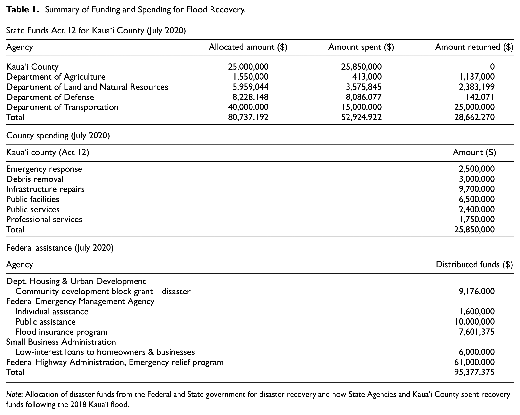
Note: Allocation of disaster funds from the Federal and State government for disaster recovery and how State Agencies and Kaua`i County spent recovery funds following the 2018 Kaua`i flood.
Approximately 90 % of the repair costs were covered with the Federal Highway Administration (FHWA) Emergency Relief Program, which assists states with repair and reconstruction costs from extensive damage caused by natural disasters ( 27 ). Approximately $61 million has been allocated from FHWA. The remaining costs of transportation repairs were made with funds from the State’s Act 12 funds made available on May 10, 2018. The measure set aside a total of $100 million to finance disaster recovery and mitigation efforts on Kaua`i and other islands from recent natural disasters. Additional post-disaster recovery funds for Kaua`i County also came from the Department of Housing and Urban Development (HUD), the Federal Emergency Management Agency (FEMA), and the Small Business Administration. Funding from foundations, community organizations, and insurance has supported and financed recovery from this disaster.
In addition to the disaster recovery funds for physical repairs and improvement to infrastructure, the North Shore Shuttle program was initiated with a $1.5 million grant from the county’s emergency flood-relief funds. The North Shore Shuttle program is also part of planning and management for Hā`ena State Park. The plan ( 19 ) addresses long-standing traffic and parking problems. The plan manages travel demand by implementing a reservation system and providing reserved parking for park visitors. Before the April 2018 flood, visitor counts in Hā`ena State Park were approximately 3,000 visitors per day. Improvements to the parking lot and implementation of the parking reservation system reduced visitors to approximately 900 per day ( 30 ). Another project to reduce traffic congestion and parking is the implementation of the North Shore Shuttle, which provides transit service to Hā’ena State Park, Ke’e Beach, and the Kalalau Trail access for those without parking reservations. The shuttle ran for 10 months from June 2019 until the COVID-19 pandemic resulted in a shutdown of visitor arrivals to the State ( 31 ). The shuttle plays an important role in reducing traffic and parking demands on the North Shore and providing other environmental and social benefits for residents and visitors.
Discussion
Transportation systems are critical assets for the response and recovery from disasters. The landslides and flooding, which closed the main highway, meant that vital emergency services, police, fire, EMS (Emergency Medical Services), and also crucial lifeline systems for power, water, communications, waste management, and other health and safety functions were disrupted, threatening health and safety and the quality of life for residents and visitors to the North Shore. The helicopter evacuation of stranded residents and visitors was costly and difficult to manage and implement. The need for community-based and volunteer actions to save lives and support rescue, evacuation, mass care, sheltering, and recovery is also evident. Efforts to increase preparedness and planning and support communications before, during, and after hazardous events will save lives and hasten the recovery processes.
There are familiar lessons in after-action reports and recovery evaluation studies, including the need for strong cooperation and support of government and community-based emergency response groups and timely turnaround for disaster response and recovery that can be applied to pre-and post-disaster recovery plans ( 8 , 32 ). There are also pragmatic and operational procedures for managing evacuation, coordinating volunteer efforts, and managing re-entry to damaged communities ( 7 ). While, on the one hand, priority must be given to visitors to return home, there are also urgent needs for vulnerable, at-risk, fragile residents with medical conditions and limited mobility. The concerns for special needs populations must also be addressed when normal systems for paratransit, public transit, and other transportation services have been compromised and travel modes shift suddenly to helicopters or marine vessels ( 33 , 34 ).
Another takeaway from the Kaua`i case is the need for deep local knowledge of the underlying exposures, vulnerabilities, and risks based on where people live, work, and engage in social activities. Understanding land use, urban development, human activities, trip generation, and movements within and between neighborhoods are essential to effective evacuation, search and rescue, and the recovery of damaged areas ( 35 ). Better integration between risk and hazard mapping and assessing damage to roadways and travel networks is essential to prioritizing response and recovery actions. Real-time situation awareness, predictive modeling, and understanding movements across time and space support efficient and effective disaster management ( 6 , 36 ). The loss of power, telecommunications, and the damage to facilities and equipment located in the community required establishing a mobile command and control center and staffing and supporting incident command, search and rescue, damage assessments, and service restoration. Response efforts required coordination across the county, State, national agencies, and non-government organizations (NGOs). Pre-existing agreements, protocols for mutual aid, and coordination between a neighborhood and island-wide and off-island actors are essential to response and recovery ( 37 ). Rural communities often have close-knit relationships between neighbors and local businesses, which are the first lines of defense and response during hazard events. More attention to social capital—bonding, bridging, and linking capabilities—supports clean-up, debris-management, and recovery from disasters ( 38 ). The importance of these relationships between government agencies and agriculture, resorts, construction, building trades, and other industries involved in clean-up and recovery was often mentioned by informants familiar with Kaua`i’s flood recovery.
More attention should focus on mitigation and adaptation to reduce the risks of flooding and landslides, such as advanced warning systems and hydrological and geological models, or resilient design, construction, and materials ( 6 , 39–41). It is costly and difficult to implement pre-disaster mitigation plans, and often there are other priorities and problems that take precedence over investment in hazard mitigation projects. The ongoing concerns over traffic, parking, and managing externalities associated with mass tourism can divert attention from addressing the risks of climate change, flooding, and natural hazards. Yet, the high financial costs and disruption to the community may encourage greater attention to resilience planning and mitigation of hazards and threats. Communities often wait for disasters to occur to address mitigation and longer-term adaptation needs ( 42 ). FEMA’s Hazard Mitigation Grant Program ( 43 ) provides resources for mitigation projects. Still, these grants are linked to disasters that have occurred, and funding is based on the total amount of FEMA spending for both individual-assistance and public-assistance projects. More attention to ensuring that recovery projects build back what existed before the disaster and include improvements and changes to increase the mitigation, adaptation, and resilience is recognized. Still, it remains a tall order given the laws, regulations, policies, and procedures for authorizing, spending, and evaluating disaster recovery projects ( 42 ).
It is clear from this case and others ( 3 ) that there needs to be greater coordination and alignment between FHWA, FEMA, HUD, and other federal agency disaster recovery programs and State and local initiatives to allowable expenses, reimbursement, accounting, auditing, and reporting requirements. While disaster declarations and emergency orders facilitate spending and actions for clean-up and emergency repair work, many concerns were raised over contracting, procurement, allowable expenses, liabilities, and compliance with environmental, OSHA, and other State and federal regulations. County, State, and national systems for procurement need to be better aligned and harmonized ( 3 , 44 ). Concerns over liabilities and the potential for fines and penalties for non-compliance with regulations and policies were often raised as the principal causes for delay, inaction, or not attempting novel or innovative actions for disaster recovery.
Large disasters generate uncertainties as to how and when systems will recover ( 44 ). It is also clear that recovery is more complicated, lengthy, and involves many stakeholders than response functions. The diversity of actors also means competing priorities, alternative approaches, technologies, and systems to establish broad goals and implement and finance specific actions. While reopening the highway was a universally shared overarching goal, the processes and procedures mainly relied on established, conventional, standard approaches with a high likelihood of approval and reimbursement from the U.S. DOT, FHWA, and other federal agencies. While the State legislature appropriated $100 million to support the recovery efforts, the principal motivating factors focused on ensuring reimbursement from the federal government rather than implementing novel or innovative actions to enhance the resilience of the transportation system. The roadway alignment was largely unchanged. Conventional tactics using imported materials, technology, and labor for hillside stabilization and flood control were implemented. Implementation of nature-based, green infrastructure solutions was limited because of uncertainties about their effectiveness and the likelihood of federal reimbursement. Nature-based solutions and green infrastructure use natural materials and processes to reduce impacts such as erosion, wave damage, flooding, and landslides and provide alternatives to conventional, concrete systems for drainage, hillside stabilization, and transportation assets protection ( 45 ). In Hawai’i and it’s community, there is strong awareness of climate change and an increased frequency of extreme rainfall and flooding events, but opportunities to design, test, and implement new systems such as permeable pavements, detention and retention systems, and other green infrastructure tools ( 41 ) have been rather limited.
While a focus on urgency and reliability in engineering practice and federal reimbursements of spending is understandable, the need for more context-sensitive design, planning, and engineering for resilience seems too apparent. Although a State highway runs through the region, the North Shore of Kaua`i is still a somewhat secluded community that is reluctant to change to increase visitor traffic and the environment. Thus, efforts need to be made to consider the safety from floods and landslides and the communities and lands through which the highways pass. Planning, designs, and engineering of the highway safety improvements should be sensitive to the community.
Additional research is needed to improve rural transportation systems as well as weather and climate resilience and environmental quality. Context-sensitive design, environmental impact assessment, geotechnical analyses, infrastructure planning, maintenance and operations, recovery support functions, improved predictive capabilities, transportation health and safety, and addressing needs of tribal and other underserved communities should all be part of the roadmap to rural resilience ( 46 ).
Integrating resilience efforts into transportation agency core functions including planning, engineering, construction, maintenance, operations, and administration remains an ongoing challenge ( 47 ). Three challenges for transportation agencies include (i) lack of understanding of how resilience is related to risk assessment and management, (ii) few metrics to measure and operationalize transportation resilience and the return on resilience investment, and (iii) a lack of connection between resilience and broader transportation goals including safety, infrastructure health, and system functionality ( 47 ).
The recovery was also challenged by changes in leadership at the local and national levels and the emergence of the pandemic and other disasters, which have strained resources, attention, and focus. The challenges are not unique to Kaua`i and are likely to persist because of climate change and the difficulties of planning and managing uncertainty.
A bright spot of the recovery was the Hā`ena State Park Plan, which had strong local leadership, planning, and coordination of assets and resources. The involvement of local actors, from the community, who are deeply aware of the needs and concerns of the community, supported recovery efforts. In addition to addressing ongoing, persistent transportation problems, the lessons in regard to the management of travel demand, largely but not entirely from visitors, as well as addressing the long-standing parking and congestion problems through parking lot improvements, registration system, and the shuttle bus, is an exemplary case of “building back better.” In addition to planning, engagement, communications, coordination, and resource sharing, the approach shows the value of travel demand management. Coupled with enforcement of illegal parking, proposed earmarking of fines to support transportation improvements, and building robust data systems for monitoring traffic and shuttle bus ridership, the pandemic also created a “quasi-experimental design” where researchers and the community could collect data and observe conditions with and without the visitors. This is a clear example where data from traffic sensors and other traffic information was of critical value in planning and monitoring system performance. Part of the strategy for “building back better” is to use local knowledge to envision what “better” means for traffic, what transportation looks like, and how to learn from disruptions and disasters.
Conclusions
There are limitations to this research. It was conducted largely during the pandemic, and travel and meetings with informants were restricted. The research is based on limited site visits and communicating with planners and engineers preoccupied with important recovery efforts. Yet, the team was able to travel and conduct site visits four times and to hold in-person meetings and workshops to review the initial findings. Many email and virtual meetings were also conducted, and presentations on the methods and platforms have been disseminated at national meetings and conferences. The findings and conclusions have been reviewed by project managers, community leaders, and other informants. Some of the observations are unique to Hawai’i and of limited value to other communities worldwide but the general findings concerning the reluctance to implement novel solutions or strong adaptation projects are relevant to other communities. The research contributes to case studies and an improved understanding of theory and practices on disaster recovery ( 8 , 42 , 48 ). There are, however, common findings and research gaps arising from other weather disasters, such as the Superstorm Sandy (2012), flooding in Iowa (2011), and Tennessee (2010), which have shown that “reimbursement from federal programs drive State practices, and also that investments in training facilitate response and recovery” ( 3 ). Recent research in Puerto Rico following Hurricane Maria points to the importance of addressing social equity especially related to jobs and livelihoods during recovery ( 49 ) and the challenges of supply chain management for materials and equipment needed for rebuilding, especially for island states ( 50 ). In this case, as with others, the need to support the reopening of businesses and other economic activities in the community increased pressures to complete repair work as quickly as possible. There was less attention to “building back better” than restoring highway operations as quickly as possible because of the importance of livelihoods and activities. While there were opportunities for improving environmental justice and enhancing social equity, the focus was more narrowly prescribed by allowable expenses and reimbursements from the federal government. While the researchers have worked closely with traffic engineers, transportation planners, architects, and those in the construction industry, there was little opportunity for broader participation and engagement with roadway users and those directly affected by the disruption of the transportation system and the challenges of recovery.
While there was success in restoring the functionality of the highway using conventional engineering and the community was successful in addressing longstanding parking and congestion problems, more work needs to be done in developing and transferring technology to support rapid damage assessment and integration with disaster recovery planning, with a strong focus on transportation assets and systems.
Future research will examine processes and procedures related to evacuation and managing roadway access during disasters and recovery. There were valuable lessons from implementing the scheduled convey system and other strategies for managing control, access, and re-entry to communities damaged or cut off by disasters. Hazard events requiring robust and responsive transportation systems will likely arise again ( 2 , 3 , 37 ). There is a need to go beyond initial after-action reports to investigate and disseminate longer-term lessons and improvements to support response and recovery. Robust mapping and visualization tools developed for this project (ArcGIS storyboard [https://storymaps.arcgis.com/stories/6ee73d72139d436f8f2dd8a78503245c] and a modified Google StreetView platform [https://www.sitetour360.com/ndptc/#node13269,0.01,0,70,4]) provide useful assets to support risk assessment, situational awareness, and planning for response and recovery. Advances in technology ( 6 , 36–38), as well as further attention on green infrastructure ( 41 ) and addressing underserved populations (33–35, 49 ), need to be part of the research agenda.
There were also valuable lessons in conducting workshops with stakeholders, focusing on both describing what happened and comparing the modelled and estimated damage to the work, drawings, and feedback from engineers and project managers working at repair sites. The visualization tools used by the university team also provided a basis for emergency managers, first responders, and community leaders to make recommendations as to how best to improve response and recovery. The comments and recommendations were notated on maps and documented as part of the research process. Bringing together satellite imagery, aerial imagery, and imagery collected by the team supported understanding as to what happened and how to mitigate and “build back better.”
More research on longer-term climate adaptation and the planning, design, and construction of nature-based transportation assets will be part of the work in Hawai’i and other states prone to flooding and landslides. The FHWA has developed an implementation guide to assist practitioners how and where to best use nature-based solutions to improve the resilience of coastal roads and bridges ( 45 ). This guide covers nature-based solutions in the planning process, conducting site assessments to determine whether nature-based solutions are appropriate, identification of key engineering and ecological design parameters, permitting approaches, construction techniques, and monitoring and maintenance strategies ( 45 ). With this guide, further research was conducted to identify potential areas that would be benefit from green infrastructure or nature-based transportation solutions. The research team investigated and developed a framework for the use of vetiver grass—Chrysopogon zizanioides (L.) Roberty—as a cost-effective control and mitigation solution to reduce erosion, landslides, and flooding along the transportation corridors of Kuhio Highway ( 51 ).
There is a need for more attention on climate change impacts in mountainous areas ( 52 ) and for developing new methods of estimating the impacts of extreme events on transportation infrastructure, which will rely on additional case materials and evaluations of recovery projects ( 53 ) and extending the analysis of both risk assessment and asset management ( 54 ). A major undertaking is sorting through the different resilience measures ( 55 ), as applicable to not just recovery metrics but also stronger mitigation and adaptation, which are difficult to implement given the urgency to restore damaged systems and the difficulty of implementing novel solutions as demonstrated in this case. The lessons from Kauai are just as difficult to learn and implement as they are in Puerto Rico ( 49 , 50 ) or other states ( 3 , 8 , 55 ). The need for standards, guidance, and best practices that can be applied in unique local settings with widely varying ecological and resource constraints is apparent.
In addition to risk assessment and quantifying returns on hazard mitigation investments, data on disaster recovery spending must be made more widely available. Testing tools and technologies to support flood and landslide detection, risk reduction, and roadway resilience are underway. Research and training to support transportation and community resilience are central to the National Disaster Preparedness Training Center (ndptc.hawaii.edu) and the Pacific Urban Resilience Lab at the University of Hawai`i. Greater collaborative efforts across disciplines and between those who construct, repair, maintain, and manage transportation assets and the communities they serve will support increased resilience and quality of life. One approach being investigated is the formation of an after-action review to examine the planning and decision-making that occurred in compressed time to better understand alternative mitigation strategies and the reduction of barriers and constraints based on the actions taken in response to the 2018 flooding. The opportunity for further evaluation and deliberation of resilient recovery approaches would be valuable to Hawai’i and beyond.
Footnotes
Acknowledgements
The authors would like to acknowledge Kaua`i County, the State of Hawai’i Legislature, and the Governor’s Office for their support throughout this project. The authors acknowledge the support of the team from the National Disaster Preparedness Training Center and the Pacific Urban Resilience Lab at the University of Hawai’i and RM Towill Corporation and Oceanit, Inc. The authors are especially grateful to Ford Fuchigama, Larry Dill, Elton Ushio, Lyle Tabata, Jeremy Lee, Mike Dahlig, Joel Guy, Darcie Yukimura, Makaala Kaaumoana, Sarah Henley-Shepard, Mina Morita, Chipper Wichman, Mehana Vaughn, Rob Porro, Nadine Nakamura, Ron Kouchi, and many others who provided information and support of the research.
Author Contributions
The authors confirm contribution to the paper as follows: study conception and design: K. Kim, J. Chun, E. Yamashita; data collection: K. Kim, J. Chun, E. Yamashita; analysis and interpretation of results: K. Kim, J. Chun, E. Yamashita; draft manuscript preparation: K. Kim, J. Chun, E. Yamashita. All authors reviewed the results and approved the final version of the manuscript.
Declaration of Conflicting Interests
The author(s) declared no potential conflicts of interest with respect to the research, authorship, and/or publication of this article.
Funding
The author(s) received no financial support for the research, authorship, and/or publication of this article.

The authors are responsible for any errors or omissions from the study.