
Abstract
There is some degree of inaccuracy around the ethnic and kinship categories frequently assigned (eighteenth to nineteenth centuries) to Paposo colonial local groups on the Atacama Desert coast (25°S). Furthermore, the data referring to colonial Paposo does not give a clear insight into the number of settlements that formed it, its exact geographical location, and its occupational frequencies due to how inaccessible this Chango indigenous enclave was to the Spanish crown. This problem has been analyzed with a documented genealogy of the native coastal families and a review of Atacama's Estancia and mining colonization paradigms.
Introduction
The inaccuracy regarding the population in the early colonial Paposo on the Atacama Desert coast could be pointing to an overlooked phenomenon related to the imprecise and variable ethnical, genealogical, and kinship descriptions present in the first censuses of the native population, because some of them account for monogamous mestizo families, much in line with the Christian family structure form the Inquisition, whereas in others we see the presence of an indigenous natural filiation together with syndiasmic 1 categories like the “aggregates.” 2
From a regional and geographic perspective (Figure 1), this is a fact that probably reflects the nature of these population censuses as written sources in the Atacama Desert coast since the seventeenth century until the implementation of the Civil Registry in 1789, 3 in which we know about the variable categories that notaries assigned to ethnic and kinship indigenous attributes, with individuals and families that were indistinctly classified as “Indians,” “mestizos,” or “cholos,” and even some descriptive terms that are hard to interpret, like “coquina” and “cotinti.” 4 In this regard, in the Libro de Varias Ojas (sic) record from the Chiuchiu parish (1611–1698), we see names from families described as “mestizo” for Cobija, which lies 167.7 miles to the north from Paposo, but in other population records, from the seventeenth and eighteenth centuries at coastal Tarapacá and Antofagasta, we see families with the same surnames described as “Indians.” 5 These variations in the Atacama coastal population records of localities like Paposo could have been essential for producing this information that contemporary censuses deem contradictory. 6
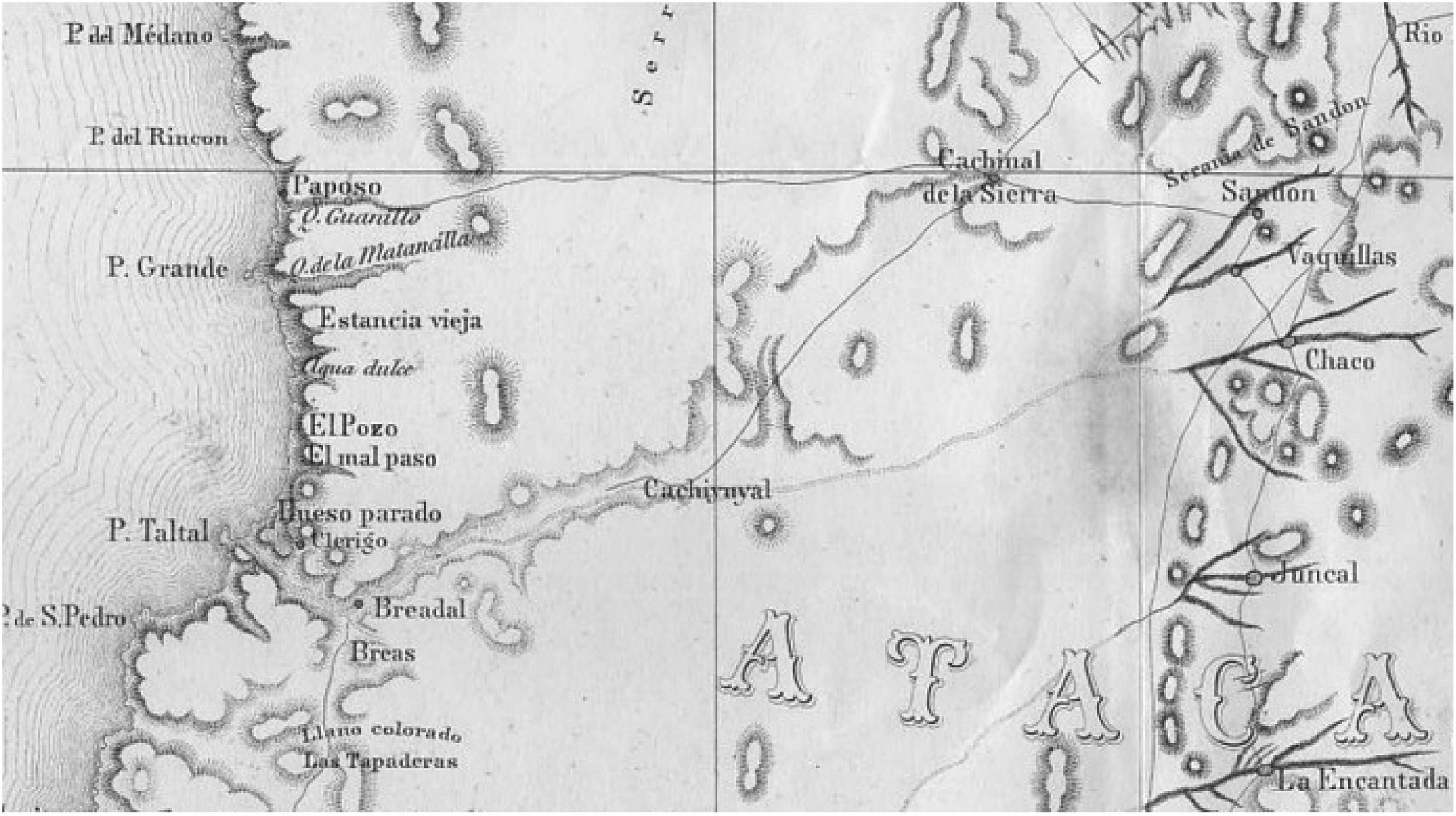
Map of Philippi (1860) for the area of Paposo. (Achieved from https://www.geovirtual2.cl/Desierto-Atacama-1/Atacama-Salitre-materiales-historico-01.htm, November 13, 2022, 0.05 h).
As we have pointed out, 7 the cause of these inaccuracies is directly related to the inaccuracies in the location of the current Paposo cove, at the coast of Taltal in the Atacama Desert, which partially matches the site and the extension assigned to the colonial Paposo area during the Spanish administration and the emerging republican life of Chile and Bolivia between the seventeenth and nineteenth centuries. According to ethnohistoric and ethnographic sources, the so-called “historical Paposo” or “colonial Paposo” was a population core spread between three settlements and several coves with semi-permanent occupation along the coast of the territory named Estancia de Paposo, a concession of land and encomienda of “Indians” granted by the Spanish crown to the Chileans who were the descendants of Spanish conquistadors. However, its location and population have not been confirmed by any of that time's censuses and ethnographical descriptions (de la Cerda, 1792; Almendares, 1793; Araya and de la Barrera, 1803–1806, and Valdivieso, 1841) (Figure 1). 8
According to the researchers Lazo and Téllez, 9 what caused this population scattering in Paposo was the high mobility adopted by the Changos or native coastal groups due to the colonization and the mining boom, especially among the male adults (a behavior also seen in other native cultures of the Atacama Desert region, like the Likanantai and the Aymara, among whom there are even categories of absence 10 ), which lead to highly variable colonial censuses. Thus, the censuses carried out in Paposo since 1782 and onward do not give accurate numbers for the population in that Andean enclave, which was around 140–150 inhabitants according to Governor Avilés in 1782, 152 according to Almendares in the report to Governor O'Higgins of 1793, 232 for Araya and de la Barrera at the beginning of the nineteenth century, 400 for Mellet in 1824, 200 for Fitz Roy in 1832–1833, 190 for Valdivieso in 1841, and 500 for Philippi in 1853. 11
This research seeks to explore ethnohistoric, ethnographic, and ecclesiastical primary and secondary sources that discuss aspects tied to the confusion over the population estimations written down by notaries and travelers until the nineteenth century and confirm the potential relationship with the imprecise location of Paposo and the reasons which could have led to this. And above all, the goal of this study is to comment on the demographic context of colonial Paposo and other neighboring localities regarding the scattering and the genealogical roots of the southern native coastal groups in the Andes region, first classified as Camanchacas, Proanches, or tributary Indians, and, since the eighteenth century, treated homogeneously as Changos, which adds to the discussion data about the genealogies of the native families.
The Coastal Population at the Beginning of the Colonial era in the Andes Region
It seems that “Camanchacas,” or “Camanchas,” was a widely spread ethnonym in chronicles and public documents used to speak about native groups located between Arequipa and Cobija until the seventeenth century, as it is stated in the Pleito de Ocurica from 1572 in Arica, the Probanza de Méritos by Francisco de Otal (1622–1652), the Libro de Varias Ojas (LVO) record since 1611, and the Tasa de Santillán of 1558, 12 among other documents. South of this coastal territory, at Cobija, the LVO from 1646 to 1662 also accounts for individuals categorized as “Proanches.” All of them were indigenous peoples from the southern Andean coast between Cobija and Caldera. 13 In this coastal stretch, some native groups began to be called “Chiangos” in the seventeenth century, 14 which later became a widespread denomination, as “Changos” in the documentation of the eighteenth century. 15
Some of these first depictions of the native coastal groups date from the sixteenth century with Geronimo de Bibar and corsairs like Drake, Cavendish, and Hawkins. 16 However, it was not until 1605 that they were described in more detail and called “camanchacas” for the first time by the Spanish Dominican priest Reginaldo de Lizárraga in his work Descripción breve de toda la tierra del Perú, Tucumán, Río de la Plata y Chile. For Lizárraga, “From here [Atacama] one enters the big Despoblado of 120 leagues ranging from here to Copiapó, which is the first repartimiento of the Realm of Chile (…) in this stretch of land there are some small coves with a small amount of salty water, where some Indian fishermen have retreated, poor and almost naked (…) These Indians are called Camanchacas because their faces and the leathers they wear have turned into some sort of red and hard crust.” 17
However, significant information about the Camanchacas is provided in the Tasa de Santillán document of 1559. 18 According to his visit to the Chilean north in 1558, Hernando de Santillán describes the caciques who led Indian towns in the Copiapó Valley, who in turn were under the jurisdiction of the encomienda of Francisco de Aguirre. There were six caciques or principales, Francisco, Don Diego, Tiquitiqui, Don Alonso, Hernando, and Ticalcañaca, all with indigenous people ready to work in mining, agriculture, home care, textiles, and fishing. Nevertheless, only two of these had groups of Camanchacas under their control: Francisco with a group of Camanchacas fishermen on the coast of Copiapó and another on the north coast of the Atacama, and the cacique Don Diego with a group of Camanchacas in the port (probably Caldera or Morro Moreno). According to other sources, from Cobija the cacique Pedro Liquitai also commanded, around the year 1591, a group of Atacamas and Camanchacas settled in Atacama Desert coast region, the latter engaged in the exchange of dried fish (charquecillo). 19
In addition, just as Liquitai, the cacique Don Alonso reportedly had three indigenous people called “fishermen” or “challwacamayos” under his control, who are not classified as Camanchacas. Could this differentiation have its origin in differentiated taxation? Without a doubt, this is a point that should be further explored in the future. 20
As a part of the southern Andean coast and according to the Chilean civil records, the settlement of the Paposo area carried out by the Spanish Crown started with an encomienda and a land grant of a coastal stretch to Francisco Cisternas Villalobos, an influential creole from Copiapó that later became chief magistrate. 21
The encomienda of Paposo was paid with fourteen media anata pesos by Cisternas Villalobos to the general captain of the Crown, Juan Henríquez, in 1679. His descendants imposed on the local population an Estancia system based on farming and mining. The document of the encomienda to Cisternas notes that “he obtained it in the 4th of July of 1679, with an extension of one thousand and five hundred blocks distributed by equal quantities at the points called Guanillo, Quebrada de Camarones and Lomas de Llampi [Llompi], and its boundaries are the seas and the mountain range from West to East, the Miguel Díaz gorge to the North, and the Guanillo gorge to the South.” 22 A pioneering group of Spaniards and creoles from the Copiapó valley settled in a small estate at the Llompi hills, next to the Junquillar aguada, and established the administrative center of the Estancia Paposo (Figure 2). 23
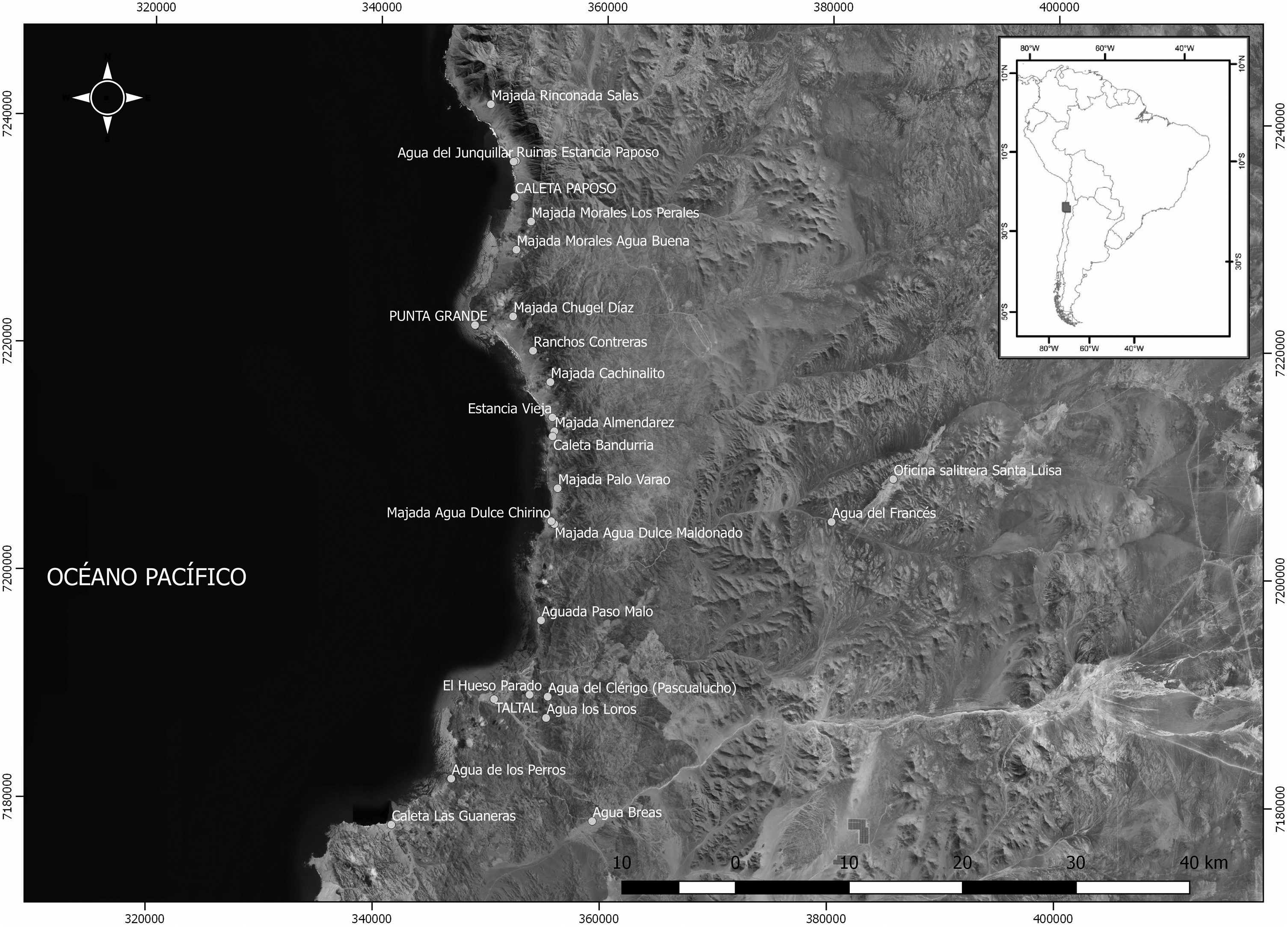
Historical/pre-modern toponymy for Paposo and its surroundings (data from Castelleti and Torres, “Territorio y genealogía,” 2023).
The settlement of Paposo was the result of an active coastal network. As many authors point out, 24 the growth of the mining industry in the Atacama Desert during the nineteenth century and the first half of the twentieth century entailed a sprawl of pirquineros (independent miners), and a high mobility and settlement in the region, especially among the adult males, which is written down in various civil and ecclesiastical records from their population centers. 25 However, before the mining boom and the development of the modern cities of Antofagasta and Taltal, and prior to the nineteenth century, the locality of Paposo and its town was one of the most important settlements on the southern Andean coast. In this context, and as we will explore later: What happened, genealogically speaking, with the traditional population centers like Paposo since the expansion of the mining industry in the Atacama Desert, or even before that time? 26
After the independence from the Spanish crown in 1813, the First Government Junta of Chile commanded an official census for the entire country, which revealed a population of 570 inhabitants in the cove of Paposo, one of the few villages with a native population in the Atacama Desert. 27 Between 1808 and 1820, the French citizen Julian Mellet depicted the nineteenth-century Paposo in his journal Viajes por el interior de la América meridional as a “village inhabited by tributary Indians that is governed by a subdelegate and a cacique (…) The population of Paposo is approximately 400 inhabitants.” 28
Other documents from that era are more specific than the journal from Mellet. For instance, Captain Robert Fitz Roy, in his second reconnaissance trip for the English crown in 1835, depicts Paposo in the following way: …at a latitude of 25.02° S, we find Paposo, the northernmost village on the shores of Chile. This is a miserable place with around 200 inhabitants, with a mayor; the huts are scattered and are not easy to distinguish from the hills in the background because they have the same color. (…) The mines are 7 or 8 leagues away to the south, but only a few have been exploited. Timber and water can be obtained in reasonable amounts (…). The ships heading this way will enter the parallel 25.01, and when they are 2 or 3 leagues away, they will see the white islet in front of Punta Rincon and, afterward, the white hill of Paposo.
29
At Paposo, we had the chance to observe the Indians from the Chango tribe, a peculiar remainder of the primitive population. All the Changos are fishermen; they ask the sea to provide the food they cannot get from the desert, which starts at the beach and extends indefinitely.
30
However, it was Philippi, in 1853, who consistently depicted the administrative Estancia Paposo (24°57′), a walled bastion located approximately 700 m away from the Junquillar water body, where the administrators and other settlers lived, and which featured the warehouse where a room for the parish was built; there also was an “Atracadero” (quay) for boats located at 25°0′2'’, about 1.9 miles to the south of the Estancia and closer to the Paposo ravine, and in this last place, according to Philippi, there were around twenty Chango houses next to the aguada. 31 That quay or “atracadero” was probably the area that captain Fitz Roy described between 1834 and 1835 as “Paposo” (25°02′), with around 200 inhabitants. 32
The mining boom at the Estancia Paposo was the direct result of its lease to the Copiapó resident José Antonio Moreno in 1853, who performed the first mining requests for the area of Paposo and Caleta el Cobre, thus laying the foundations for the current port of Taltal, 33.5 miles to the south from the Paposo cove.
33
Between 1853 and 1854, Rodulfo Amando Philippi systematized the information about the coastal section of the desert or “Despoblado de Atacama” inhabited by native settlers gathered around Paposo, an area that he visited himself: The amount of people living on the coast is about 500. Men and women live apart most of the year; the former devote themselves to fishing or mining jobs, and the latter keep themselves busy feeding the goats and constantly moving from one place to another as they find pasture and water. When the raging sea does not allow fishing, men go hunt guanacos in winter. There are no true marriages between these people (…). Children stay with their mothers until the males are old enough to perform men's jobs.
34
For Philippi, the Paposo area of 1853 consisted of a group of about twenty Chango houses located in a plain next to the quay, plus the Estancia with its perimetral mining grounds a few miles to the north, where the administrators José María and Mariano Zuleta lived (Figures 1 and 2). Some houses were used as a parish and a warehouse, and there were also Chango ranches at the Junquillar aguada next to it. 35
Regarding the Christian evangelization on the coast of Paposo, the early missions, all of questionable nature, 36 precede the first missionary Rafael Andreu Guerrero who stayed in Paposo for short periods between 1796 and 1799, followed by Araya and de la Barrera during 1803–1804, 37 and Rafael Valdivieso in 1841. 38 This situation only changed by the end of the nineteenth century when the vice-parish of Taltal was established. 39
Lazo and Téllez (1984) suggest that in 1806, for about two months, the priests Tomás Araya and Isidoro de la Barrera went to the parish in Paposo to convert their 233 mestizos who lived within sixty leagues. 40
Subsequently, Santiago Rafael Valdivieso, the priest from the diocese of Santiago, arrived in 1841 to carry out an evangelizing mission for a month with the military chaplain Joaquín Vera and José Ignacio Víctor Eyzaguirre. The report from Valdivieso in 1841 accounts for the location of Paposo in detail, at 25°03′ and 70°30′. 41 Valdivieso mentions that the total population in the territory of this Estancia was 190 people in twenty families (Zuleta, Almendarez, Velásquez, Castillo, Díaz, Maldonado, Aracena, Sandoval, Maturana, Cotaypi, and Contreras, among others). 42
According to this author, in the half of the nineteenth century, “Junquillar” is at the center of the entire Paposo estate, and here is where the houses of the administrator are.
43
However, he also mentions that the accommodations for priest Rafael Andreu Guerrero were not at Junquillar nor by the quay but at the “Estancia Vieja,” three leagues (12.4 miles) to the south from Junquillar, which was another known coastal settlement in the area. Three leagues to the south from Junquillar, at the place called Estancia Vieja, are the remains of the house inhabited by the distinguished Mr. Rafael Andreu Guerrero before he became the Bishop of Epifanía […] It is said that there were plans for creating a village here.
44
Non-Consanguineous “Aggregates” among the Coastal Families in Paposo
Several ethnohistoric data allow us to discuss essential aspects from the daily life of the families in Paposo during the eighteenth and nineteenth centuries and to contextualize them regionally (Tables 1 and 2). Although the first Western depictions of the Atacama Desert coast region were made for Cobija, 167.7 miles to the north from Paposo, besides the brief descriptions of the Chango groups made here by Bauver in 1707, Feuilleé in 1709 and d'Orbigny in 1828,
45
the most detailed depictions of the native coastal families appeared in 1825, in the journal Voyages aux îles du grand Océan by the French-Belgian diplomat and explorer Jacques-Antoine Moerenhout. Moerenhout hands essential data about the traditional family organization of these groups, which was usually structured as a nucleus joined by marriage and with some potential “aggregates”: In our journey through the coastline, outside the locality called Cobija, we encountered several Indian families whose houses had sea dog hides hanging on four sticks […] One of these families was formed by two men of middle age, two women, and several children, and they all slept in the same hut with nothing more than two covers in bad shape.
46
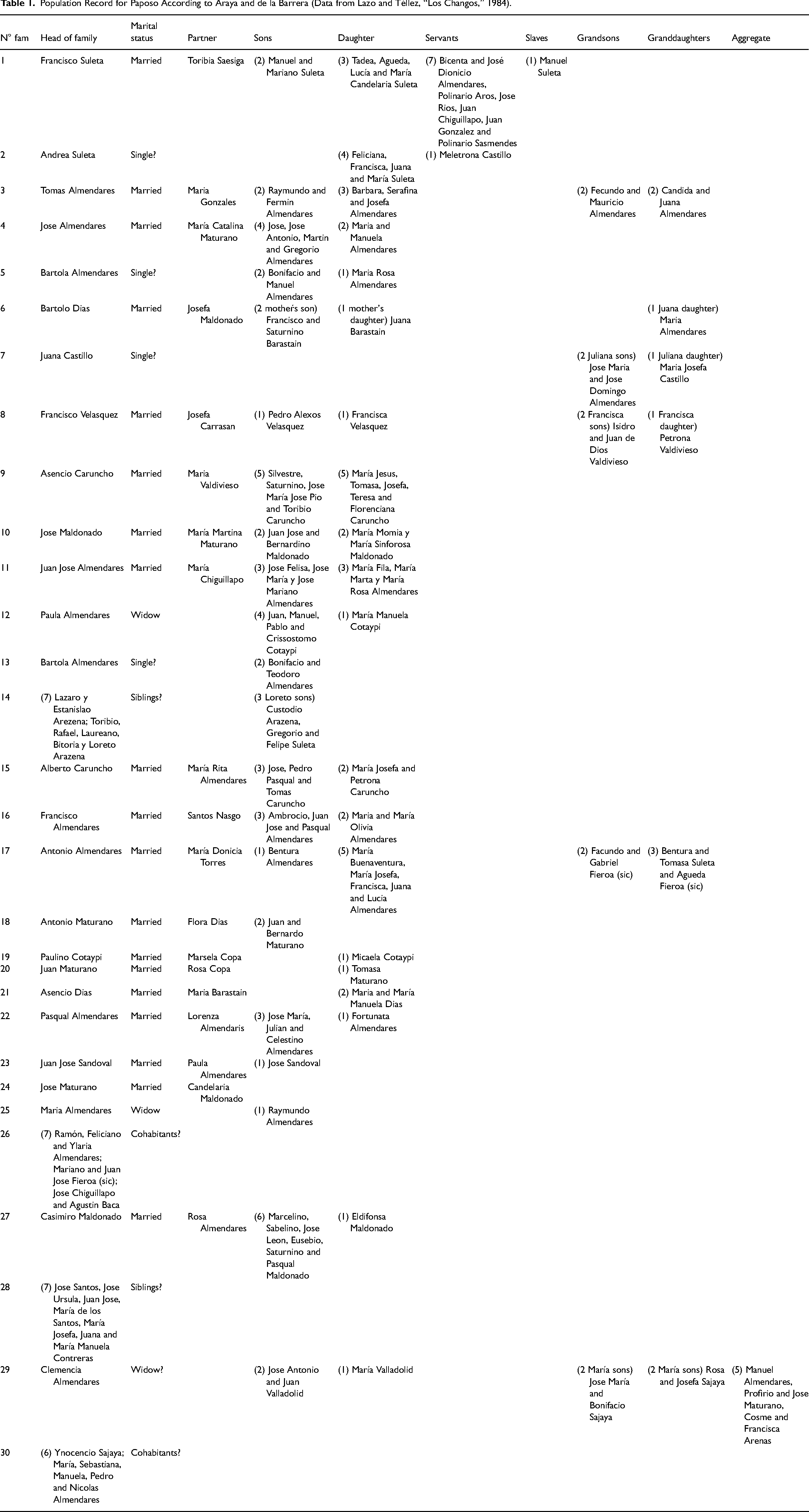
Population Record for Paposo According to Araya and de la Barrera (Data from Lazo and Téllez, “Los Changos,” 1984).
Detail from the Indian Census by Eduardo De la Cerda in Paposo, 1792 (Data from Cortés Larravide, “Algunos datos,” 2019).
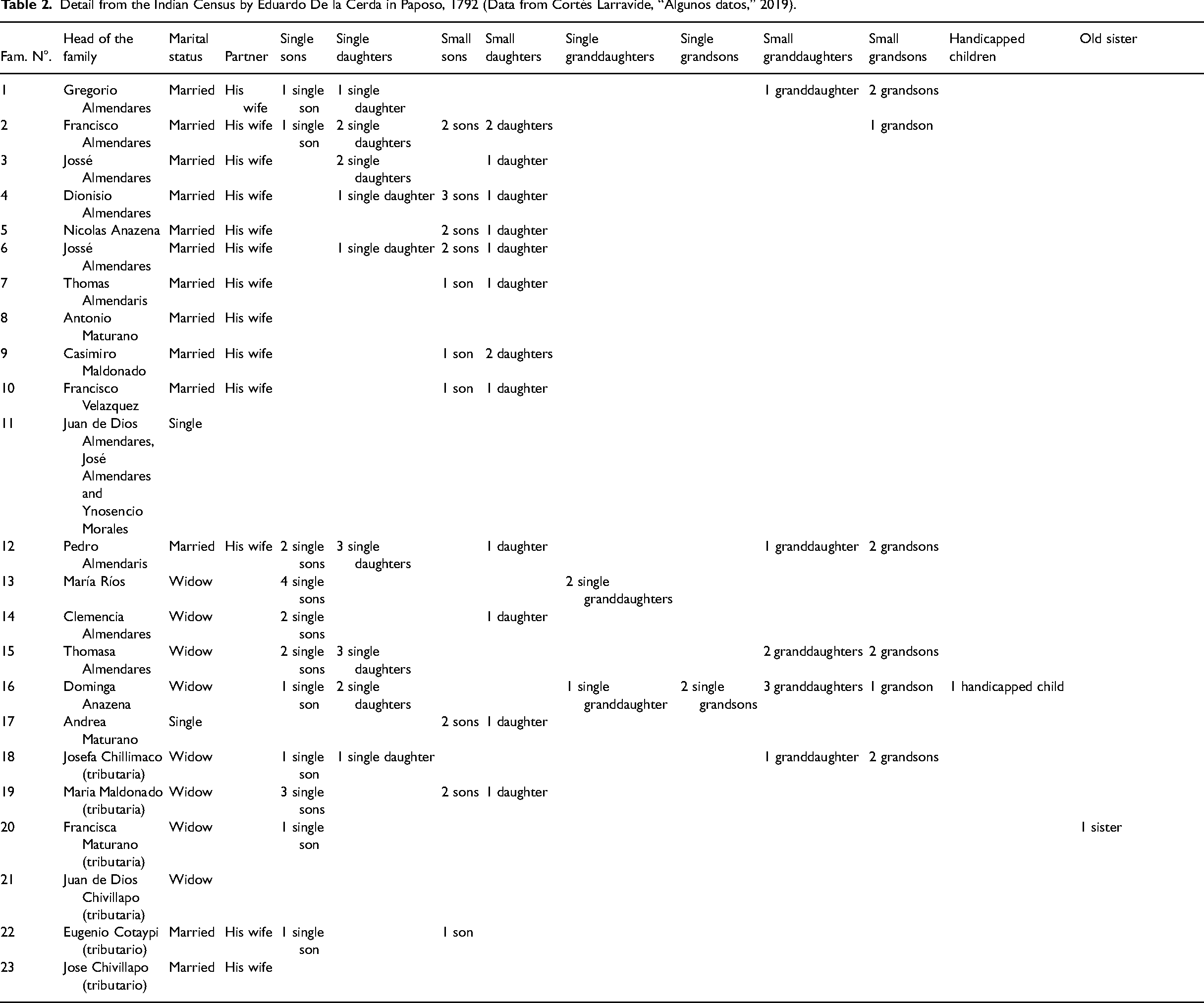
Nevertheless, another recently published ethnohistoric document states that in 1792 the Royal Sub delegation of Copiapó commended the census of Paposo to Eduardo de la Cerda, who informed seventeen families and six tributary groups, with 106 individuals in the first group and twenty-three in the second one 50 (Table 1). This registry does not account for the non-consanguineous family categories that Araya and de la Barrera describe ten years later 51 (Table 2), thus opening the controversy around this problem in the studies of Chango kinship.
Discussion
The review of ethnohistorical and census records for the Estancia de Paposo points out a lack of accuracy in explaining the difference in population frequencies from the different primary sources and the disparity of the information in each census for this locality, in addition to the unsystematic genealogical records in which we see some surnames with variable spelling, different ethnic categories, and complex definitions for kinship relations among the native families. This could be the result of the poorly described populated cores, in terms of location, and the extension of the boundaries of Paposo during the Colonial and early Republican periods. 52
The scarcity of documentary records about genealogical aspects in Paposo drove us to search for other primary sources to characterize the kinship structure from these groups, allowing us to track specific surnames. Although population frequencies in Paposo grew from 1792 until now, it would be feasible to associate these evident statistical variations with the high mobility, migration, and dispersal among the native families triggered by the Estancia system since the seventeenth century and the mining industry starting from the nineteenth century. Those documents show us that, while the records about the families in Paposo account for the insertion of non-consanguineous members into the local families, these families maintained their traditional matrilineal kinship structure during the eighteenth and nineteenth centuries, and this led to more complex marriage strategies and parental filiation, which included consanguinity, patrifocality and the addition of external individuals. 53
A basic element to discuss regarding the settling of Paposo is the ethnic affiliation of its native population. The variables used for the censuses starting in 1792 leave some questions about the assigned categories of “Indian,” “mestizo,” or others. However, some of the data is meaningful. In the first place, the six “tributary Indians” in the report from de la Cerda in 1792, which had surnames of the native families of Paposo like Maturano and Maldonado, is a key aspect, especially if we consider that 100% of the ethnographic descriptions for the local groups in this period identify them as “Indians” or “Changos,” as it is confirmed by Mellet (1824), Bresson (1840), and Espinoza (1897) in the nineteenth century, and by Latcham and Capdeville in the twentieth century. 54
So, what could have been the territory of Paposo, in which the censuses were carried out, during the eighteenth and nineteenth centuries? In this regard, the accounts of Philippi (1860), Matte Varas (1981) and Hanisch (1984) 55 clearly state that the Estancia Paposo was a land and an encomienda of Indians granted in 1679 by the Spanish crown to Francisco Cisternas Villalobos and his descendants. 56 However, besides the Llompi hills, the administration houses of the Estancia, and the quay 3.7 miles to the south, the rest of the local population centers seem to be highly variable in number and permanence, as stated by the civil workers and travelers in their reports. In 1794, the seafarer Alejandro Malaspina confirmed this dispersion that occurred before the mining industry boom in the nineteenth century. He counted forty-nine groups of native fishermen in Paposo, nineteen in Cachinaldo, 57 146 between Caldera, Morro, and Obispo, and thirty-seven in Huasco. 58 Later on, in 1828, Willian Bollaert sailed to the coast of the Atacama Desert, visiting Cobija at 22°28'S, where he visited native groups he called Changos, also fishermen who settled in the coves around Paposo. In addition to Cobija, Bollaert also encountered native groups in the open sea, where he tells us that three Changos “came off in a seal-skin balsa out of Caleta de Cordon, bartering their dried conger fish for flour and coca. On the twelfth day, three more Changos came off from El Rincon (a fishing cove), and on that day, I anchored in Paposo, where I found a few families, people of Copiapo, who were here to barter for dried fish with the Changos. (…) At Punta Grande were three or four families of Changos, and at Agua Dulce, half a dozen more, who had a few goats and asses. Having traversed the dangerous Mal Paso, I came to Hueso Parado, 25°30′ (this spot was shown to me as the divisional point with Bolivia). At Salinas, I found four or five families of Changos.” 59
This account seems to indicate that, before the mining industry boom in the area, which started in 1853 when the Estancia Paposo was leased to Juan Antonio Moreno, not only the western population nuclei were scattered between two or even three places which were 13.6 miles away from each other. To the usual (mostly male) mobility among the Chango groups, we must add that the Chango households also followed a mobility pattern, which could be a direct cause of why many of these encampments were not registered or just partially accounted for by the civil or religious officials.
The context described above could have been why many Changos were not registered as “Indians” or “tributaries.” As Bollaert pointed out in 1828, “the Changos move from one cove to another; they told me they belonged to the district of Copiapo but paid no tribute. (…) I saw about one hundred, I allow fifty more fishing north of Cobija, and another hundred traveling in the interior would make two hundred and fifty souls.” 60
The European colonization scenario in Paposo first entailed the establishment of a cattle farm to provide charquecillo to Potosi (seventeenth and eighteenth centuries) and later the mining industry boom in the nineteenth century. 61 This resulted in a sprawl of encampments for mining exploitation and processing, in addition to the majadas that were part of a complementary crop and livestock production, as indicated by the historical pattern of exploitation in the Atacama Desert. 62 Thus, a single-product production system was imposed on the native families. This context for the local groups encouraged the development of new mobility strategies to avoid being registered and paying tribute altogether, as well as new kinship alliance strategies that could ensure necessary resources for the families, which included the addition of non-consanguineous members to the families of Paposo along with a potential cohabitation due to marriage between groups of non-related brothers and polygamous practices while keeping the traditional matrilineal structure. 63
With the foundation of the Estancia Paposo in 1679, it is possible that the practice of passing down the surname was imposed on the native Changos in the area. 64 This was, without a doubt, one of the objectives of the first visits recorded for the diocese of Copiapó, to which Paposo belonged, carried out by the bishop Juan Bravo de Rivera in 1743 and by Alday in 1757. 65 Among the first census records for the population of the Estancia Paposo, in 1792, 1793, 1803/1806, and 1813, we see high frequencies for families with the names Almendares, Maturano, Castillo, and Caruncho (Tables 1 and 2), which Mellet (1808), Bollaert (1828), Bresson (1840), and Philippi (1853) would describe culturally and ethnically as “Changos” or native inhabitants. 66 This cultural identity remained alive even at the beginning of the twentieth century, as stated by Latcham y Capdeville. 67
This recorded pattern of continuity and high frequencies among the Almendares, and, to a lesser extent, other families with Spanish and indigenous names that appear in the early documents about Paposo, before and during the mining boom in the Atacama Desert, suggests that this surname could be related to other groups registered as Almendares (Almendariz) at Cobija from 1622 to 1698 in the Libro de varias ojas of the Chiuchiu parish. These documents also contain Spanish surnames of groups that were apparently mestizo and related to the Almendares, like the Acosta, Castillo, Díaz, Gutiérrez, Mondaca de Cisternas, Mundaca, and Morales, as well as other names belonging to indigenous or native families like the Jaguaña, Sajaña, and Cotaypi. 68 In this context, coastal family names like Maturano, Maldonado, and Castillo seem relevant. The Castillo could be found at an ayllu in the port of Yqueyque (Iquique) and was explicitly described as “camanchaco” in the Baptisms and marriages Book 1 of San Lorenzo de Tarapacá parish (1689), in association with the native surname Camachí: “María Rosa, [from] Camanchaca ayllu (…) the legitimate daughter of Juan Castillo and María Camachi,” and “María Camanchaca, (…) natural daughter of María Castillo.” 69
A relevant aspect of the Camanchaco ayllu found in Yqueyque since the seventeenth century, as stated in the baptismal records of the parishes of San Lorenzo de Tarapacá (1685–1706) and Santo Tomás de Camiña (1653–1695), 70 is that their marriage alliances have the same “aggregates” structure recorded in Paposo and probably in Cobija, with individuals that arrive at the coast from the interior, showing that the camanchaco local families like Chocoi, Usinco, Caiona, Pacoma, Sillai, and Castillo, who pass down their surname preferably through female lines, integrate a masculine element from the inner altiplano with surnames like Caio, Choque, Mamani, Saplau, Gualchar, Guaitari, and Quispe, who probably were drawn to Iquique due to work on the silver mines of Huantajaya, 7.4 miles to the interior from the port.
The situation for the Caruncho families is more complex. According to some recent genealogical studies, this name could have arrived at the Valley of Pica in Tarapacá with the Galician subject Francisco Caruncho Rey in 1660, who in 1665 married Micaela de Aller, who would later change her surname to Díaz. Thus, the Caruncho established marital bonds in Pica before the nineteenth century with families of Spanish names like Morales, Capetillo, Salazar, Ramírez, Hidalgo, Elgueta, and Ríos, among others, as well as with indigenous families like Huarcaya, Colquema, Cayo, and Payta. 71 The lack of earlier genealogical records for the Caruncho in the study of Roa y Ursúa (1535–1810) and the LVO from the seventeenth century support this hypothesis. 72 According to the genealogical tree for the Caruncho in Pica, we could suppose that there was some crossbreeding when this family moved to other areas of the Atacama Desert-like Paposo, where the earliest record for Caruncho appears between 1803 and 1806. 73 As we can see in the records, at Paposo, the Caruncho, and the Almendares had a close family relationship since the beginning of the civil and ecclesiastical registries in the nineteenth century. 74 Some recent ethnographic accounts 75 describe Humberto Almendares, an inhabitant of the Estancia Vieja until he died in 2018, and Mario Caruncho Almendares, an inhabitant of Taltal, who stated that the gorges of El Hueso and Los Loros were colonized by Pasqual Caruncho Almendares, the renowned sea otter hunter (chungunguero) 76 whose descendants were called the “Pascualucho,” a family dedicated to horticulture and raising goats in that area for almost two centuries. It can be seen in the first baptismal records between July 14 and August 24 of 1879 from the parish of Taltal (Table 3) 77 in which, among the fifty-three children baptized in Paposo that year, plus a dozen at the majadas, seven were Caruncho and twenty were Almendares, with natural filiation in all cases but for one Caruncho-Camplanchai alliance, and two Caruncho-Almendares unions that were then crossed out and their offspring registered as natural children.
Libro I (1879) de Bautismos, San Francisco Javier de Taltal parish (Data from ACDEAA [Archivo Central del Arzobispado de Antofagasta], 1879, Baptisms Book 1, San Francisco Javier de Taltal parish).
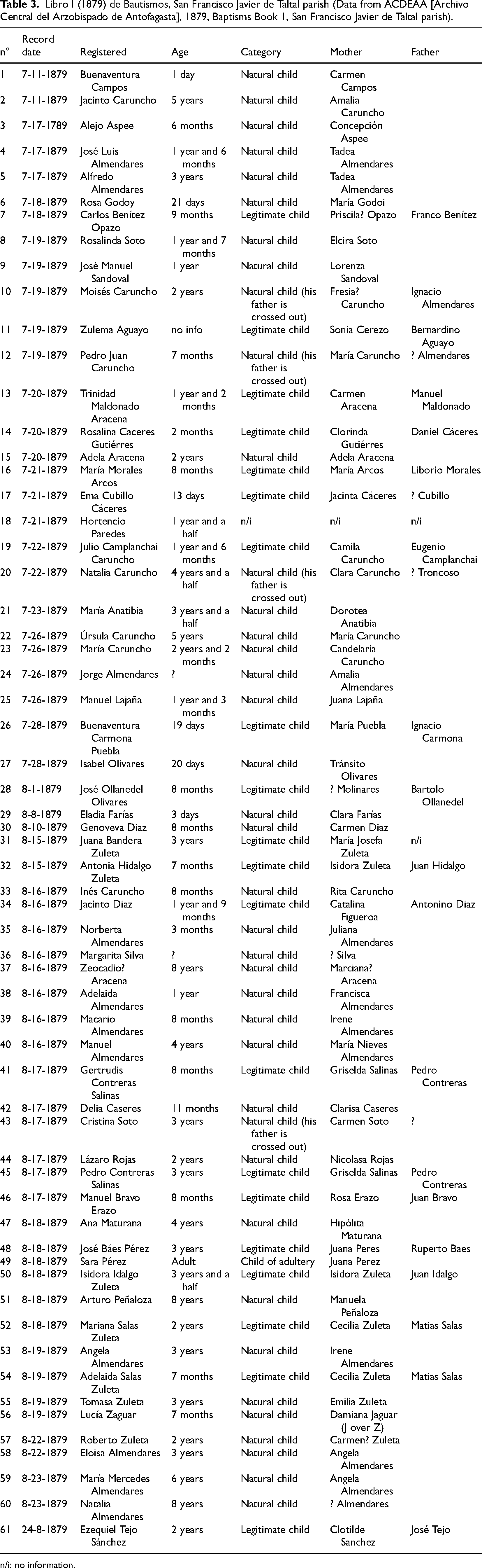
n/i: no information.
As the report from the delegate Gregorio Almendares of 1793 states, the people registered in Paposo that year had kinship relations with the inhabitants of Cobija. 78 This allows us to confirm the relationship between the Almendares, Maturano, Sajaya, and Chivillapo families in several fishing coves from the southern Andean coast, but it also adds new information on the origins of allied groups like the Caruncho, who became a mestizo family in Paposo and other localities. 79
All this information suggests a very particular phenomenon regarding the relationship between some of the foundational Andean coastal families, like the Sajaya, from the Loa to Cobija, the Almendares, located between Cobija, Paposo, and Caldera, the Aracena, from Taltal to Huasco, and the Alvarez, from Huasco to the south. 80 For the Almendares, although no records have been found to clarify the prehispanic genealogical background of these coastal families, the historical accounts suggest that in the seventeenth and eighteenth centuries, they led the kinship networks of the indigenous families on the shores of Cobija and Paposo and to the south 81 since the eighteenth century within a context of multicultural and multi-ethnic interaction. 82 In this process, while the coastal families engaged in endogamic practices, 83 frequent alliances by marriage, godfatherhood, and probably the addition of non-consanguineous “aggregates,” this was performed in an exogamous context, which until today has produced alliances with foreign and local families while keeping the matrilineality and, with this, their origin tradition. 84 In the case of Paposo, this fact becomes patent when we check the details of the alliances and kinship affiliation in the civil and ecclesiastical records from the eighteenth and nineteenth centuries, where the Almendares and other common groups would usually expand their lineages by natural filiation and by alliances and cohabitation by marriage with members from other families like the Caruncho, Maturano, Gutiérrez, Chivillapo, or Copa (some of them were of indigenous origin). Under this context, they settled new territories with groups formed by the new generations, and this was possible due to the traditional patrifocality. 85
For Paposo, one of the main triggers of the dynamic historical kinship scenario for the native coastal families was the establishment of the Estancia Paposo in 1679, which was a Western nucleus that imposed a system of tribute and commerce to the local population based on single-product activities like the making of charquecillo, goat and mule farming, and mining. 86 Due to this, the ancestral territoriality shifted into the modern settlement pattern seen in their families, which includes majadas as shelters of semi-permanent occupation, areas of coastal exploitation, and the permanent settling of a populated center (Paposo and/or Taltal). The Estancia Paposo further developed the dynamic Andean coastal process of social interaction and commerce routes, especially after the mining boom of the nineteenth century defined the geography of the scattering and traditional family alliances present until our days in that territory, with the Almendares representing the main group at Paposo, Estancia Vieja and their surroundings, the Caruncho at El Hueso, the Chirino at Palo Varao, the Castillo and the Gutiérrez at Cachinales, the Contreras at Matancillas, the Díaz at Aguabuena, the Morales at El Guanillo, and the Salas at El Rincón. All these groups merged with other families from the cove of Paposo, the town of Taltal, and several local beaches and coves (Figure 2). 87
This data seems to be very relevant when we review the available ethnographic and ethnohistoric information from primary sources about the scattering of native family names that now live in the territory of Paposo/Taltal, like the Almendares, Gutiérrez, Morales, Castillo, and Zuleta (Suleta), 88 as seen in the records of the Chiuchiu and San Lorenzo parishes from the beginning of the seventeenth century. 89 We also notice this scattering pattern in Cobija, where some Almendares families interacted between the seventeenth and eighteenth centuries with other groups, like the Maturana, González, Otal, Ligero, Yaychas (Ayta, Aytas), Cotaypy, Saxaya (Sajaia, Sacaia), Chuquina, Chaylli, Chivillapo, and Chacón. 90 In these parish records, we can see that during the seventeenth century and probably until the beginning of the eighteenth century, some Spanish surnames acquired by the coastal families at Cobija coexisted in a daily multiethnic context with surnames registered as “Camanchaca” (Chucho, Liquena, Cauallolo, Caun, Ycotan, Collama, Chilloco, and Chuquina), 91 and even with some classified as “Proanche,” mainly between 1646 and 1652, who belonged to the coast, between Morro oy Cerro Moreno and Copiapó, like Alaguana or Jaguaña, Chacaguaina, Anchuño, Clapiche (Chalpiche), Cancota, Coimas, Cherepe, Chamalco, Chiquin, Lacmor, Laicor, Maqueta, Quilama, and Sacaya (Sajaya, Sacalla). 92 What parental relationship led the family groups on the southern Andean coast? Although we do not know, the cause is undoubtedly linked to genealogical regulations.
As Lehnert explains 93 in his study about the evolution of surnames in the Libro de Varias Ojas, in this record, we can see an evident graphical instability for names and surnames, especially among the indigenous individuals, in which we see how the indigenous names progressively get replaced by Spanish denominations. For Lehnert, in addition to the ethnic description of some of the registered individuals, one striking aspect of the LVO is the high frequency of certain qualifiers in the seventeenth-century records, like “coquina,” which was added to the name-surname combination. Its meaning is unknown but could refer to productive roles and/or kinship categories. 94
The above finally resulted in the high territorial dispersion seen in their family groups, which probably was, as we said, connected to the high mobility of some of their familial segments based on the family alliances with local and foreign groups.
The historical context of the Chango groups’ dispersal along the southern Andean coast and the genetic studies of the native population of Paposo carried out by Rothhammer have confirmed a prehispanic genetic footprint as old as the Chinchorro groups (ca. 7000–4000 BP) and later genetic links with the Aymara and Likanantai. 95 The analysis of the population scattering in Paposo allows us to draw a complex alliances background between coastal native groups and others from the inner Andean regions by means of exogamous and endogamous practices within the estate and mining systems that were implemented in Atacama since the seventeenth century, creating a regional kinship network that in Paposo was sustained by a—consanguineous or not—matrilineality among the traditional families that prevailed over the variable patrifocality or marital cohabitation forms that were changing. 96
The access to the baptism and marriage records (seventeenth and eighteenth centuries) from the Chiuchiu and San Lorenzo parishes in Tarapacá 97 allows us to see the real nature of these alliances among the indigenous and mestizo coastal groups and thus compare the indigenous branches associated with families like the Almendares. Although we usually see alliances with Spanish ancestors in coastal localities frequently described as multiethnic since first contact, like Cobija, Puerto del Loa, Yqueyque, Guayna Pisagua, and Paposo, if we rule natural filiation out (which is the most frequent kind among the coastal families), certain alliances are key to understand the origins of the Almendares, like the Almendares-Chivillapo, Almendares-Caques, Sajaya-Almendares, and Guacante-Almendares alliances, whose members were classified as “Indians” in parish records. This regional crossbreeding pattern is also noted among the individuals categorized as “Proanche” in Cobija, with mestizo alliances like the Delgado-Cherepe (1618) or Chamaico-Guaita (1662), to which we must add the categories of “coquina,” “cholo,” and the seemingly unknown label of “continti” (cf., Francisco Continti Chacalla “legitimate son of Vicente cholo continti and Magdalena Sacalla, his wife”). 98
According to Casassas,
99
the initial Almendares reference dates from 1654, and it belongs to Lorenzo Almendariz, registered as Lorenzo Almendaris the old in 1705 when her widow Magdalena Alicanto was still alive.
100
Since that moment, we find records of alliances between the Almendares (Almendaris) and Spanish and indigenous surnames. We have, for instance, the case of Martina Chivillapo Almendares, whose name was registered in Cobija in 1744. The Chiuchiu parish record indicates that she is the “…legitimate daughter of Pasqual Chivillapo and María Almendares, natural Indians from this port of Covija….”
101
Pasqual Chivillapo must have been an interesting individual, as he also appears in the parish record from 1748, which states that he had already baptized María because there was no priest: “…Pasqual Chivillapo, Indian, had already poured the water, and I made him appear before me to testify if he had performed a true sacrament. And being in great doubt, I baptized her, and as it was said, she is the legitimate daughter of Simon Maturano, mestizo.”
102
Chivillapo also poured the baptismal waters on another newborn child registered as María, chola, of one year, who “…is the daughter of Andrea Almendares, mestiza, single, from this port of covija, and Bernardo de Abalos tributary and from San Francisco de Chiuchiu….”
103
Also, sometime before 1747, at Cobija, he did the same with María chola …Pasqual Chivillapo, Indian, also poured the water in a situation of need, and not having any certainty of him performing a True Sacrament (…) I baptized her (…) her godparents of oil and water were Joseph Almendaris and Ysidora Maturano [and] she is the legitimate daughter of Pasqual Maldonado mestizo and Josefa Chivillapo Indian from this port…
104
Regarding the Almendares-Caques alliance, we see a record from 1719 in the parish of San Lorenzo about Diego, an Indian from Iquique, “of four months, the legitimate son of Domingo Almendares and Josepha Caques, Indians from said port….” 107 In 1732, the Libro 1 de bautismos record from the parish of San Lorenzo de Tarapacá accounts for the birth of “…a creature of fifteen days who I named María [Indian], the legitimate daughter of Lorenzo Almendares and Josepha Caques….” 108 Finally, we have the Almendares-Guacante, who, although registered in 1924 in the parish of Mamiña, to the interior of Iquique, show how far the indigenous alliances with the Almendares from Paposo and Taltal spread. On that occasion, we see the marriage of “Juan Bautista Guacante, from Mamiña, the legitimate son of María Guacante and Vicente García, with María Almendares, born and baptized in Taltal, residing in Mamiña, the legitimate daughter of José Almendares and María Amalia Caruncho….” 109
Conclusions
The historical disaggregated ubiquity of Paposo and its population are two of the elements of the coastal landscape that, since the seventeenth century, strongly defined the features of the inhabited coves and localities of the southern and central-southern Andean shores, which were openly multiethnic, as pointed out by historical accounts 110 and suggested by prehistorical sources. 111
However, it is in the kinship melting pot conformed by the families from the coast of Paposo and its neighboring localities where we clearly see the nature that this process adopted, which characterized the Chango groups scattered along the Atacama Desert coast, and that the various sources show evident discrepancies in its registration.
Notwithstanding these differences, in this area, there are registered families that, from an ethnographic perspective, are the base of the native population of Paposo, like the Almendares, Maturano, Castillo, and Morales, as the contrasted sources show. These groups have widespread roots that link them with well-known indigenous families throughout the region, like the Sajaya-Chillpa from Puerto del Loa, the Chivillapo from Cobija, the Caques, and the Camachí from Yqueyque, and the Cotaypi from Pisagua. All of them were matrilineal and resorted to natural filiation, and until today they are categorized as Changos, who, during the early colonial era, were related to families classified as Camanchacas and Proanches.
Footnotes
Declaration of Conflicting Interests
The authors declared no potential conflicts of interest with respect to the research, authorship, and/or publication of this article.
Funding
The authors received no financial support for the research, authorship, and/or publication of this article.