



Abstract
In this essay, I explore the city of Jerusalem, which not only lies at the heart of the Israeli-Palestinian conflict but is inextricably shaped by its developments. Nominally unified under Israeli sovereignty, Jerusalem nevertheless remains starkly divided between an Israeli west and an occupied Palestinian east and is best understood as a frontier city characterized by long-simmering tensions and quotidian conflict. With its future tied to the future of the conflict, Jerusalem remains caught between two options: the almost global preference for the city’s repartition in accordance with a ‘two-state solution’ and the Israeli desire to maintain the status quo. A closer look at contemporary Jerusalem, however, reveals the untenability of both options. In this essay, I seek to document how the reality of Israeli-Palestinian division sits alongside a dynamic of blurred separation in the city, which has forged an uneasy coexistence of sorts. Re-thinking the frontier as a site of both conflict and coexistence, I argue, is key to imagining future possibilities for the city that do not rest on the desire for ethnically-pure spaces, but are rather guided by a politics of co-presence that recognizes the impossibility of disentangling Arab and Jewish histories, memories and connections to the city.
Introduction
Every year around May, Israel celebrates Yom Yerushalayim (Jerusalem Day), a national holiday commemorating the Israeli victory in 1967’s Six Day War, which saw the country establish control over the Old City and ‘reunify’ Jerusalem. Close to 100,000 right-wing Israeli activists 1 spill onto the streets in marches supported by the Jerusalem municipality and escorted by police, following a route that takes them into the conquered Old City to the Western Wall (Kotel) and which, from 2011, has also included Jerusalem’s Palestinian neighbourhoods. Streets are closed to traffic and cordoned off for the thousands of white-shirted revellers and their sea of blue-and-white flags to march, chant and dance through the neighbourhood of Sheikh Jarrah to Damascus Gate (Bab al-Amoud), the main entrance of the Old City’s Muslim quarter, amassing along the narrow thoroughfare of al-Wad Street that leads to the Kotel. ‘Death to the Arabs’, ‘Mohammed was a pig’ and ‘Let your village burn’ are favoured slogans of the marchers, while Palestinian families lock themselves away in their houses, peering down from windows. Small business owners will shutter their shops, encouraged by Jerusalem’s police who are concerned about damage to property and the outbreak of clashes; a brave few will remain open, risking vandalism and assaults from the keyed up revellers. Culminating in the Western Wall plaza, the march turns into evening festivities. The sounds continue echoing into the night and over the rooftops of the Old City; its Palestinian residents fall asleep listening to the celebrations that mark their occupation.
The city of Jerusalem is, without doubt, one of the most lauded in the world. The celebrated birthplace of three monotheistic religions, it is a revered destination for the many pilgrims who come to wander the streets of the Old City, circumambulate the purported site of Jesus’ resurrection, touch the stones of the fallen Second Temple or pray in the al-Aqsa mosque, which holds its own in silver against the golden-blue Dome of the Rock. Yet, Jerusalem is also the political, geographical and cultural heart of the Israeli-Palestinian conflict (Makdisi 2010), something which is often missed by the tourists and pilgrims who marvel at its collection of photo opportunities and soft beauty. Indeed, for all the claims to its alleged ‘reunification’, the city remains starkly divided between an Israeli West and an occupied Palestinian East, and is the site of slow-simmering religious, political and cultural tensions between the two, effectively segregated, peoples. Jerusalem is quite evidently a frontier city, framed and shaped by intractable conflict and largely irreconcilable claims to ownership and sovereignty, and like all frontier cities it is characterized by both confrontation and contradiction (Pullan 2011). In many ways, the question of the city’s future is fundamentally a question about the future of the conflict; and like the conflict more broadly, the hegemonic terms of debate remained trapped between the Israeli state’s desire to maintain Jerusalem as its ‘united and complete’ capital and the global preference for the city’s repartitioning into an Israeli and Palestinian capital, as per the so-called ‘two-state solution’. Nevertheless, there is a burgeoning area of work sceptical of this dominant paradigm, with a number of scholars calling for more creative – and importantly, just – ways of imagining the city’s future (e.g. Dumper 2013; Makdisi 2010; Mendel 2013; Weizman 2007).
In this essay, I join these scholars in calling for new ways of thinking about contemporary Jerusalem. It is clear that the status quo/two-state paradigm is not only untenable, but unjust insofar as it is unlikely to solve the problems that have caused the conflict in the first place. On the one hand, Jerusalem’s ongoing divisions and tensions go very much against the Israeli claim to have ‘united’ the city, as does the persistent inequality that structures the lives and encounters of Palestinian Arabs and Israeli Jews. On the other hand, the notion that Jerusalem could be divided ‘in the middle to create a “pure” Jewish west and a pure “Palestinian” east’ is fallacious in light of the ‘facts on the ground’, which are connected not just to the 1967 occupation but also to the broader conflict (see Mendel 2013: 56).
My particular interest here is the ways in which this reality of Arab-Jewish division sits alongside a dynamic of blurred separation in the city, where Palestinian and Israeli space variously intermingles and overlays each other, forging an uneasy coexistence of sorts. Certainly, compared to the violence of the second Intifada (2000–5), which saw Arabs and Jews retreat into their separate quarters, present-day Jerusalem is characterized by a tentative, albeit asymmetrical and uneven, mixing as Palestinians and Israelis encounter each other more often in the urban fabric of the city. This, of course, is shaped by the varying regimes of dispossession and inequality that structure both the city and Israeli planning policies, something quite often (and quite rightly) pointed out by critics of various persuasions. Nevertheless, and as is my point of departure here, such regimes not only have unintended consequences that work against their underlying rationales, but also are never complete in the sense that they can do away with that they seek to ostracize (see also Busbridge in press). I take my inspiration from the idea of the frontier as a site of both contest and contact (Cavanagh 2011: 158). To emphasize only the former, as is often done in critical accounts of Jerusalem, is to reduce the frontier ‘from a zone of encounter and interaction to [merely] a zone of conflict’ (Rose and Davis 2005: iv) and is also to miss some of the more subtle – and arguably hopeful – elements of the contemporary city. As much as encounters cannot help but be shaped by the violence of the frontier, it is the possibilities of interaction and the reality of tentative coexistence that offers slivers of hope in an otherwise bleak landscape.
If Jerusalem reveals all that is most dysfunctional about the Israeli-Palestinian conflict, then, it is also in Jerusalem that the increasingly intertwined lives, histories and experiences of Israelis and Palestinians are most evident (e.g. Bashir 2011). It is the impossibility of disentangling Israeli and Palestinian space that I aim to document here through both text and image. In doing so, I make a call for a politics of co-presence in Jerusalem. In contrast to the never-ending search for roots and the desire for ethnically-pure spaces, this politics of co-presence seeks the more hopeful possibilities that lie at the interstices of blurred separation and uneasy coexistence. The only viable choice left for Jerusalem, I suggest, lies in the acknowledgement of the complexity of Palestinian-Israeli encounters, as well as their long and intertwined histories in and connections to the city which is now incontrovertibly and unavoidably both Arab and Jewish.
Borders and frontiers in Jerusalem
Despite its claim to be an ancient and eternal ‘holy city’, metropolitan Jerusalem is in fact a thoroughly modern creation and a particularly strange one at that. The borders of what is now known as ‘Greater Jerusalem’ seemingly make little sense: in the east, they are largely marked by the walls, barriers and checkpoints that supposedly separate the city from the West Bank; in the west, they fold out to the various red-roofed satellite towns that dot the hills on the way to the plains of Tel Aviv (Figure 1). As Yonatan Mendel describes, Jerusalem’s … boundaries extend far beyond its population centres, encompassing dozens of villages, barren hilltops, orchards and tracts of desert, as well as new-build suburbs with scant relation to the historical city; in the north, they stretch up, like a long middle finger, nearly to Ramallah, to take in the Old Qalandia airport, some 10 kilometres from the Old City walls, and bulge down almost to Bethlehem in the south. (2013: 36)
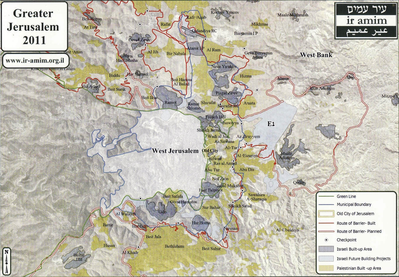
Map of Greater Jerusalem 2011. Courtesy of Ir Amin.
For all its apparent randomness, however, a closer look at the city reveals a particular logic to its urbanism – and one which is arguably not that unusual in terms of its history. Like the patchwork stone walls of the Old City, which speak to its razing and rebuilding by successive conquerors, modern-day Jerusalem wears the marks of its most recent victor; namely, Israel in the 1948 and 1967 wars, and its enduring project to claim the city as the capital of the Jewish state.
The 1947 United Nations Partition Plan (which sought to split Mandate Palestine into an Arab and a Jewish state) originally slated Jerusalem as a corpus separatum international city to be administered separately by the UN. The outbreak of war the following year, however, saw the original plan abandoned. Zionist forces conquered half of the city and Jerusalem was transformed into an Israeli west and a Jordanian-administered east, partitioned by the 1949 Armistice Line (the ‘Green Line’, so-called because of the colour of the pen used to draw it). Whereas the newly-established Israeli state formalized West Jerusalem as its official capital in 1950, the east largely languished under Jordanian rule as the Hashemite Kingdom sought to downgrade its status and also its Palestinian identity (see Shlaim 2000: 36). Its victory in 1967 saw Israel once again expand its control over the city, militarily occupying East Jerusalem as well as the broader West Bank. Subsequently, they enlarged East Jerusalem’s boundaries from the 6 sq km previously under Jordanian administration 2 by an additional 64 sq km, incorporating and annexing some 28 West Bank villages, their orchards and fields as well as wide swathes of desert into Jerusalem’s municipal limits (B’Tselem 2013a). In 1980, Israel enshrined in Basic Law Jerusalem as its ‘united and complete’ capital. For the rest of the world (including, importantly, the Palestinians themselves), East Jerusalem is illegally occupied territory and the status of West Jerusalem as the Israeli capital remains controversial.
In such a context, the Green Line as an administrative boundary between Israel as a sovereign entity and the Palestinian territories it occupies has largely lost significance in Jerusalem – from the perspective of the Israeli state at least (Newman 2012: 253). In some ways, the Green Line remains like a faint trace on the urban landscape of the city, particularly where the differences between Palestinian East Jerusalem (al-Quds) and Israeli West Jerusalem (Yerushalayim) are most evident. This is the case across Road 1 in the centre of the city, which separates the Palestinian neighbourhood of Bab al-Zahra outside the walls of the Old City from the Haredi (ultra-Orthodox Jewish) neighbourhood of Mea Shearim (Figure 2). Here, Jerusalem is experienced as two very different urban spaces, each with its own tongue, script and aesthetics. East Jerusalem remains discernibly Arab, with its Palestinian majority population and landscape punctuated by minarets and church towers; in Bab al-Zahra vendors tout coffee and kebabs, fruit and vegetables are sold in open-air markets and families relax in sheesha cafes (Figure 3). West Jerusalem is unmistakably Jewish, visually more European and home to an increasing religious Orthodox population who live in places like Mea Shearim, which is akin to an insulated Eastern European shtetl (Figure 4).
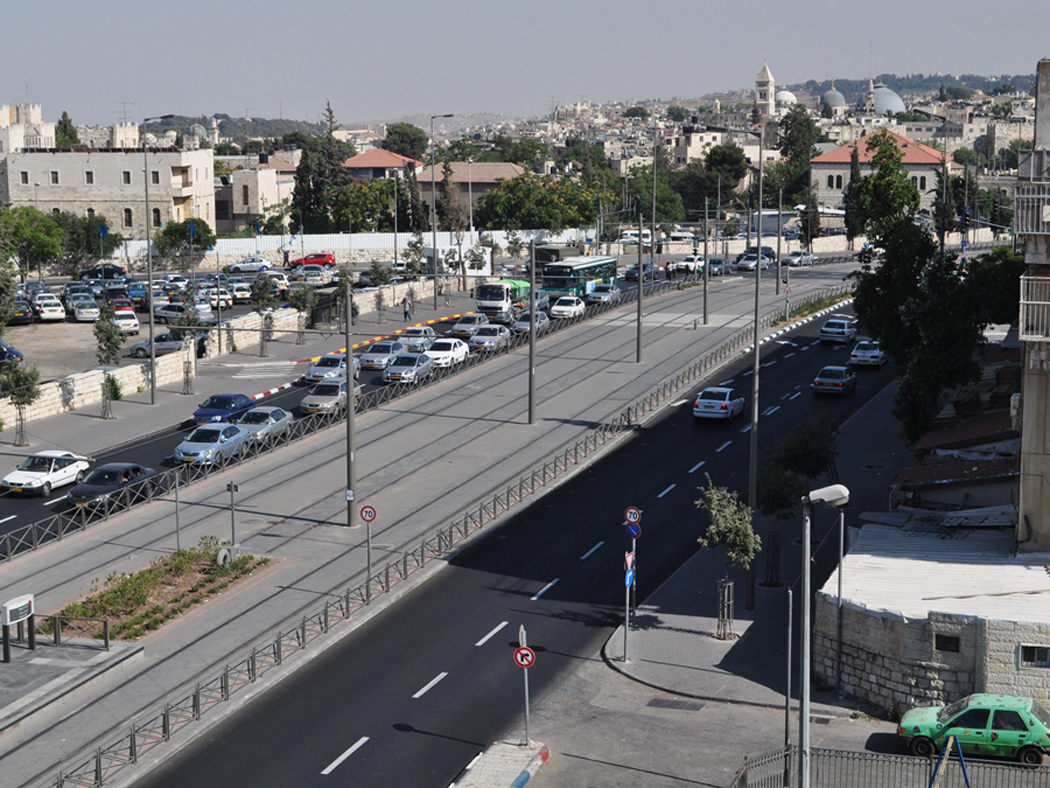
Road 1, separating East Jerusalem (left) from West Jerusalem (right).
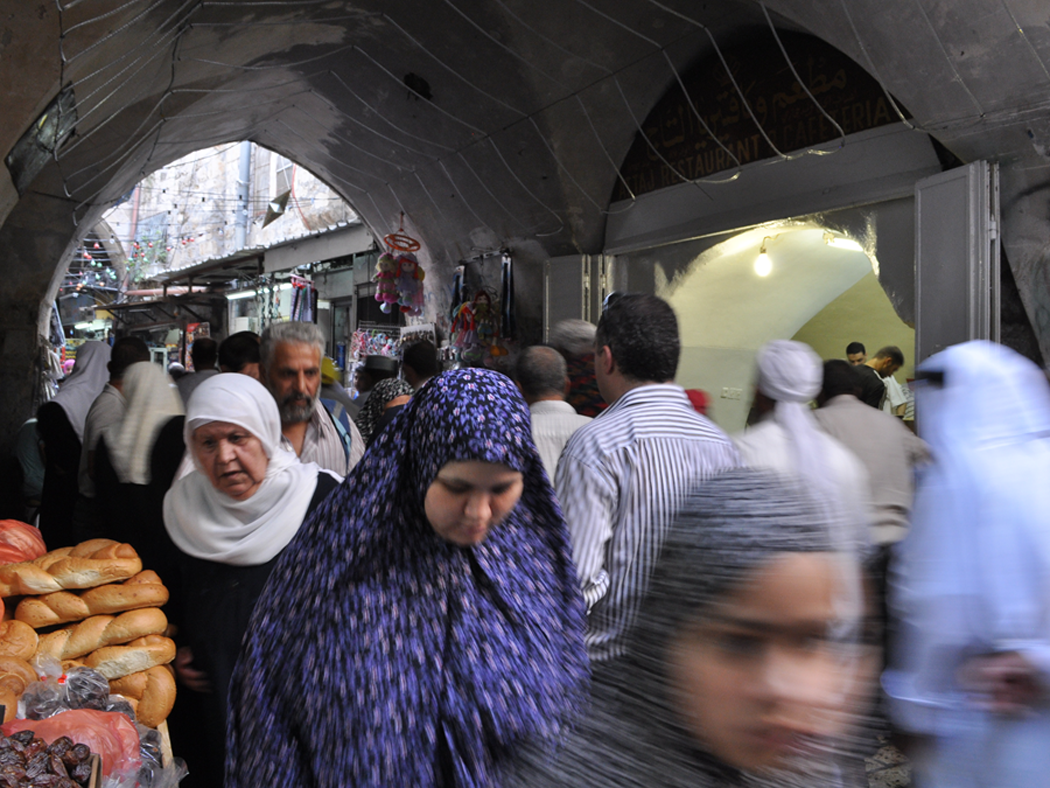
On the way to Friday prayers. Old City, East Jerusalem.
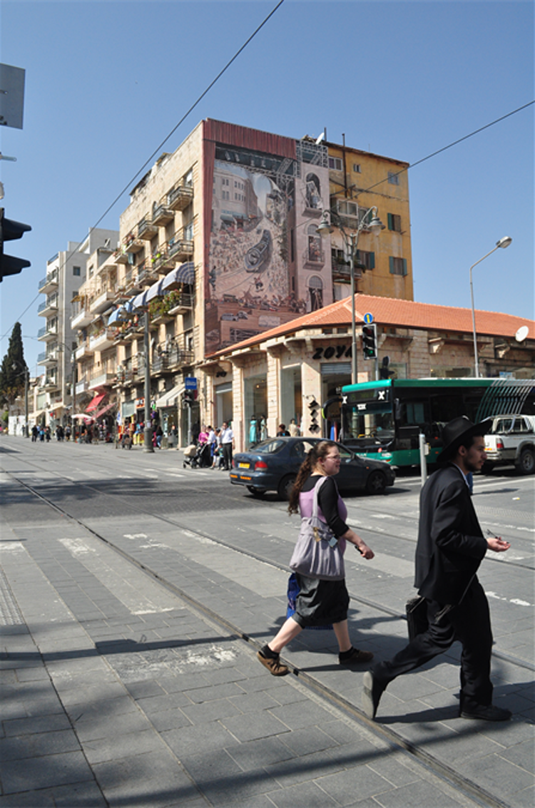
Jaffa Street, West Jerusalem.
Nevertheless, the Arab-Jewish separation that defines the city is far blurrier than is often presumed to be the case, and as much as the east-west divide is both palpable and meaningful, it should not be regarded simplistically. While it is common to imagine Jerusalem in terms of two different cities facing directly onto each other (e.g. Klein 2008), instances of clear-cut separation like that across Road 1 are not only anomalous, but largely illusory. The project to establish Jerusalem as the ‘eternal and indivisible’ capital of the Jewish state has rendered borders and boundaries equally spurious and tentative in Jerusalem, not least because it entails an active process in which Israel must simultaneously make Jerusalem Jewish and curtail Palestinian claims to the city. 3 This twin dynamic of Judaization and de-Arabization (Yiftachel 1999) is settler colonial in orientation, in the sense that it is premised on the logic of the elimination of the native and the acquisition of their land for exclusive ownership by the settler (see Wolfe 2006).
It is in this regard that understanding Jerusalem through the notion of the frontier is valuable. While borders and boundaries are traditionally conceived of as ‘lines separating sovereign territories’ (Newman and Paasi 1998), frontiers typically exist ‘when a state is taking possession of a territory, and therefore mark the expansion of state sovereignty’ (Prescott 1987: 36). Frontiers are far more uneven than are borders, and are asymmetrically tipped towards those doing the advancing. In Jerusalem, to frame the city through the east-west paradigm, or the framework of Israel versus Palestine, is to only tell part of the story. As is the case across Israel-Palestine more generally, the expansion of borders in Jerusalem has resulted in Palestinian loss of land, displacement and dispossession by virtue of Israel’s ethnic-exclusive definition as a Jewish state, which requires a Jewish demographic majority and entails differentiated rights for Jews and non-Jews. It is this settler colonial reality, and the various land, immigration, settlement and military policies that it entails, which has created a highly asymmetrical, segregated and stratified political geography in the contemporary city (Yiftachel 1999).
If the notion of the frontier points to the colonially-rooted unevenness and inequality that shapes Jerusalem, it also speaks to something critical about the relations between Israelis and Palestinians that constitute the human weave of the city’s urban geography. As I have emphasized earlier, the frontier is a site of ‘violence, replacement and nation-building’ (Evans 2009), and as such it is the place in which opposing identities appear irreconcilable – the battle at the frontier is, after all, a battle of life-and-death. Nonetheless, frontiers are ‘porous and sometimes largely imaginary’ spaces, where ‘intergroup relations [are] marked – even in conditions of unequal power – by negotiation and exchange as well as coercion and violence’ (Elkins and Pederson 2012: 2). The reality of the frontier as equally a place of encounter perhaps portends to alter the identities locked in conflict with each other, or at the very least blur them. Frontiers are never linear, formal or stabilized as we often imagine our social identities to be, but are rather ‘deep, shifting, fragmented and elastic spaces’ in which the distinction between ‘inside’ and ‘outside’ cannot be clearly marked (Weizman 2007: 4). Likewise, as much as settler colonialism seeks the elimination of the native, seemingly making ‘spatial coexistence anomalous’ (Russell 2001: 2), indigenous presence is never totally eradicated (Evans 2009; see also Guha and Spivak 1988). At the frontier, the trace of the other is always present.
What I see as most interesting about Jerusalem is the way in which the same settler colonial logic of the frontier, and its deep inequality, has manifested in quite different realities in both the east and west. It has also manifested in very different realities for the city’s Jewish population, which makes up 64 per cent of the city’s nearly 800,000 residents and is spread across the east and west, and the Palestinian population, which stands at 36 per cent and is located almost exclusively in the east (B’Tselem 2012). On the one hand, East Jerusalem is structured by the ongoing settlement enterprise with its brutal but simple modus operandi: maximum land for Jews with minimum Arabs. In the east, Palestinians find themselves pushed into ever-smaller spaces as more Israeli settlements are established and more land is claimed for Jewish use: indeed, in East Jerusalem, a mere 13 per cent is available for Palestinian construction and much of this is already built up, while 35 per cent has been expropriated for Israeli settlements (UN OCHA 2011). West Jerusalem, on the other hand, is seemingly established as fully Israeli, and yet urban space is largely constructed in such a way as to write out and over pre-1948 Palestinian history and replace Palestinian spaces with Jewish ones. Likewise, for all efforts to maintain the Jewishness of West Jerusalem, the deliberate de-development (Roy 1995) of the east has compelled an increasing Palestinian presence, even if only a fleeting one. It is these different realities, as well as their underlying connective logic, that I hope to elucidate in the remainder of this essay. Like the photographs themselves, this exploration offers merely snapshots. Yet, in first looking east then looking west, I want to journey through modern-day Jerusalem to examine the logics and dynamics of the city, as well as their transmutation into the realm of everyday life.
Looking east
For the most part, East Jerusalemite Palestinians who were unwillingly incorporated into ‘unified Jerusalem’ hold the status of permanent resident of the State of Israel, compared to Israeli residents of Jerusalem who hold citizenship. 4 This status positions East Jerusalemite Palestinians akin to foreign nationals who have freely chosen to migrate to Israel. As permanent residents, the main right afforded to Palestinians is the right to live and work in Israel, although this is subject to a number of highly restrictive conditions (see B’Tselem 2013a). Unlike citizens who may leave and return to the city at any given time, permanent residents may have their status revoked should they spend too long away from the city. Permanent residents have the right to vote in local municipal elections but not elections to the Knesset (national parliament). Furthermore, permanent residency status is not immediately handed down to one’s children and, should one have a non-resident partner, they must apply for a ‘family unification’ visa if their partner is to legally live in the city. For East Jerusalemite Palestinians, such conditions are exceedingly difficult to negotiate. Not only are family unification visas, for instance, very rarely granted, but they may be evicted from the city at any given time – it is not unusual that politically active East Jerusalemite Palestinians, especially those deemed ‘security threats’, are expelled to the West Bank or the Gaza Strip.
This permanent resident status is rendered all the more tenuous by the various policies to which Palestinians are subject by virtue of the occupation. As the Israeli human rights organization B’Tselem (2012) states, since East Jerusalem was annexed in 1967, the government of Israel’s primary goal in Jerusalem has been to create a demographic and geographic situation that will thwart any future attempt to challenge Israeli sovereignty over the city. To achieve this goal, the government has been taking actions to increase the number of Jews, and reduce the number of Palestinians, living in the city.
Jerusalem municipal policy identifies the ideal demographic balance in Jerusalem to be 72 per cent Jews to 28 per cent Arabs (Halper 2009). In order to achieve this, the municipality subjects Palestinians to a chaotic maze of planning policies, regulations and restrictions intended to thwart their presence in the city – a task accorded a particular sense of urgency because of the high Palestinian population growth rate, which is only rivalled by that of the Jewish Haredi (ultra-orthodox) community.
The settlement project plays an important role in establishing Israeli sovereignty over the east side of the city, which has undergone a striking process of demographic manipulation and urban transformation since 1967. This, as Eyal Weizman (2007: 25–6) details, was laid out in the 1968 Jerusalem master plan, the ‘first and cardinal principle’ of which was ‘to ensure [Jerusalem’s] unification’ by ‘build[ing] the city in a manner that would prevent its possibility of being repartitioned’. Central to this was the establishment of 12 remote Jewish ‘neighbourhoods’ in East Jerusalem, which function as settlement ‘fingers’ reaching in and between Palestinians neighbourhoods and villages, ghettoizing them and trapping their natural growth. The master plan also entailed the construction of a second, outer ring of so-called settlement ‘dormitory suburbs’, which were key to the expansion and enlargement of the city’s boundaries to create ‘Greater Jerusalem’. In order to weave together these disparately located settlements, a network of roads and infrastructure have been established to create the city as an organic whole; Road 1 mentioned above, for instance, connects the northern settlements of Pisgat Ze’ev, Ha Giva’a HaTzarfatit and Neve Yaacov to the southern settlements of East Talpiot, Gilo and Har Homa (Pullan et al. 2007: 178). Presently, some 200,000 Israelis live beyond the Green Line in East Jerusalem (B’Tselem 2012). 5
There are marked differences between Jewish and Palestinian areas. Palestinians pay equal taxes to Jews, and yet receive only 9–12 per cent of the municipal budget (Margalit 2010) – something that is quite evident in a brief tour of the city. Compared to Jewish suburbs in both West and East Jerusalem, which are well-serviced and often green and leafy (Figure 5), 6 Palestinian neighbourhoods in East Jerusalem are poorly serviced: trash is not collected regularly and so is often burnt in the streets, roads and footpaths are cracked or often not paved and infrastructure is limited and run-down (Figure 6). B’Tselem (2011) reports that almost 90 per cent of sewerage pipes, roads and sidewalks are found in West Jerusalem, with entire East Jerusalem neighbourhoods not connected to the sewerage system at all; West Jerusalem has 1000 public parks, 24 swimming pools, 26 libraries and 531 sports facilities, whereas East Jerusalem respectively has 45, three, two and 33. Furthermore, Palestinian areas are typically dense and overcrowded, due to a severe shortage of housing in the East Jerusalem Palestinian sector. While new Jewish settlements pop up regularly, the municipality is reluctant to grant building permits to Palestinians, which results in significant pressure for East Jerusalemite Palestinian families (Halper 2009). On the one hand, the lack of building permits means that many families build ‘illegally’ 7 and risk having their houses demolished; indeed, since 1967, the United Nations Office for the Coordination of Humanitarian Affairs estimates that some 2000 Palestinian homes in East Jerusalem have been demolished, with as many as 46 per cent of all homes currently deemed illegal by municipality zoning laws (UN OCHA 2009). On the other hand, the artificial housing shortage has inflated prices to the extent that many Palestinians are left with no option but to live in overcrowded conditions or move to the West Bank where property is cheaper. This is a precarious decision considering that permanent residents must prove their ‘continuing connection’ to the city or else face revocation of their status; as such, many Palestinians who move to the West Bank will keep a permanent Jerusalem address on which they continue to pay municipal taxes.
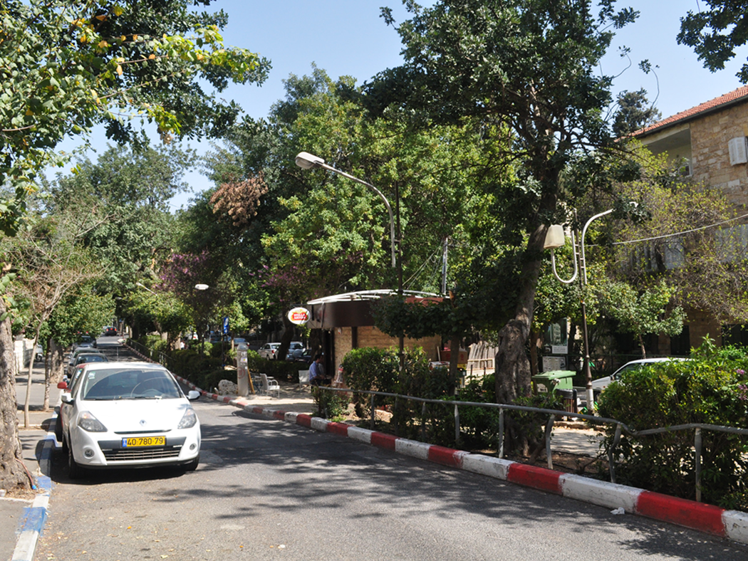
Street in Rehavia, West Jerusalem.
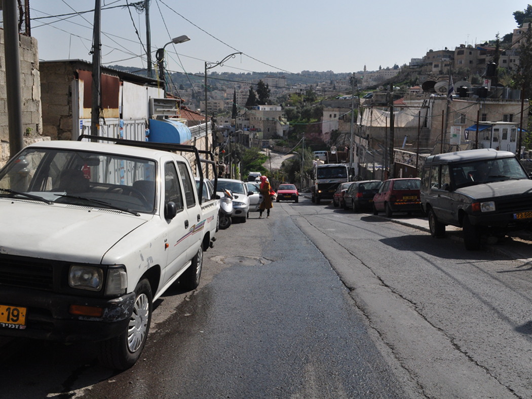
Street in Silwan, East Jerusalem.
The so-called ‘separation’ wall has arguably emerged as the dominant feature in the urban fabric of East Jerusalem, with its 8-metre-high concrete blocks dwarfing Palestinian roads, houses and buildings (Figure 7). While its construction began in 2002 as a ‘temporary security measure’ during the second Intifada, the wall is now a permanent fixture in Jerusalem, and plays a key role in designating municipal boundaries and therefore Jewish-Arab demography in the city. Tellingly, the wall’s route incorporates the settlements of the outer ring on the ‘Israeli’ side while relegating some 55,000 Palestinian residents of Jerusalem to the West Bank – and leaving approximately 1600 West Banker Palestinians inside the city’s de facto boundaries (UN OCHA 2011). This absurd situation of selective separation means that one or two Palestinian houses may be cut off from their village on the other side of the wall in a cynical calculation of land versus Arabs; at times, the wall even divides villages and neighbourhoods in two, such as in Abu Dis, or severs from the city outlying villages that previously relied on economic, social and institutional connections to Jerusalem, turning them into ghost towns. This is the case in Al-Ram (Figure 8), which lies just north of the city’s municipal boundaries and is home to 58,000 Palestinians, half of which hold permanent resident status (B’Tselem 2013b). Since the wall’s construction, several thousand have left to East Jerusalem and Al-Ram has become an enclave: many shops and businesses have closed, and the village is increasingly becoming the destination of choice for West Banker Palestinians exiled from their homes and villages elsewhere, many of whom are criminals or drug addicts. The dominance of the wall in shaping the everyday lives of Palestinians stands in contrast to its impact on Israeli settlers living in East Jerusalem. Not only does the wall’s path better facilitate their integration into the city and serve to separate them from Palestinian neighbourhoods, but it is typically landscaped where it snakes along Israeli areas or is only visible in the distance (Figure 9).
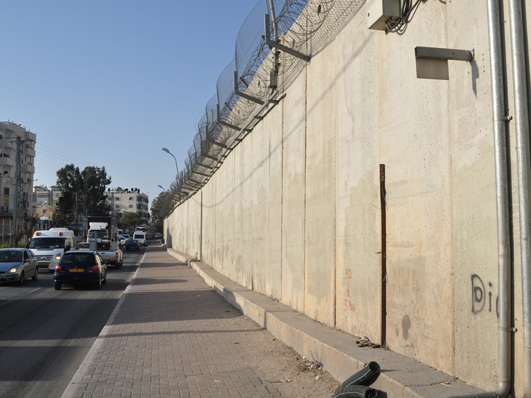
The ‘separation’ wall on the road to Ramallah, East Jerusalem.
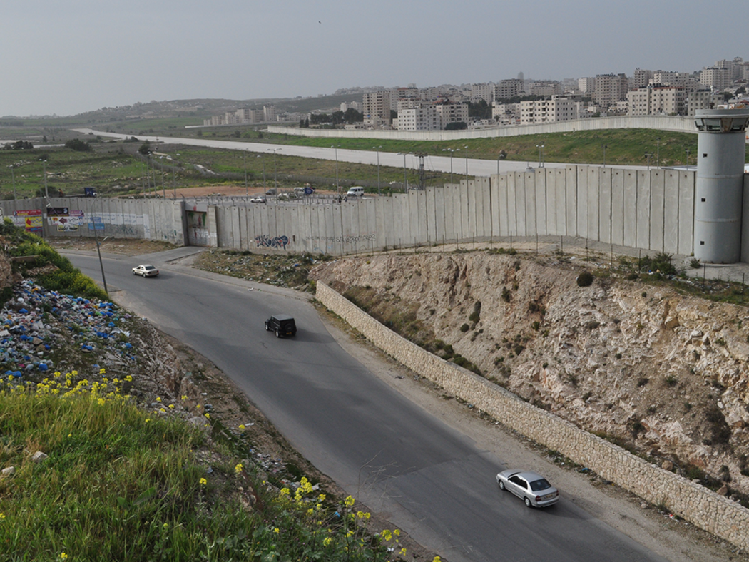
View from the other side (in Al-Ram).
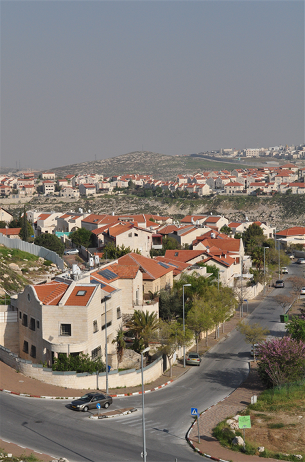
The Israeli settlement of Pisgat Ze’ev, East Jerusalem. In the background, the separation wall; behind that, the Palestinian village of ’Anata and the Shu’afat refugee camp.
As much as all Jewish Israelis living in East Jerusalem are considered settlers according to international law, it is important to point out that the relations between Palestinians and Israelis are variable. Some of the major settlement blocs like Ma’ale Adumim are exclusively Jewish gated communities; others, like HaGiva’a HaTzarfadit, see Palestinians and Jews living side-by-side, especially as rents and property prices escalate in Palestinian neighbourhoods. Certainly, the vast majority of Israelis living in East Jerusalem are considered ‘quality of life’ settlers, attracted by the cheaper cost of living and occasional government subsidies (Friedman and Etkes 2007). However, a small proportion of settlers (about 2000) are motivated by religious ideology and have established settler enclaves inside the Old City and its surrounding areas (the ‘Holy Basin’), entering into a hostile relationship with local Palestinian residents. The form these enclaves take is indicative of the haphazard, opportunistic and sometimes questionable way in which properties are procured by the right-wing settler organizations that organize them. 8 They may take the form of a building, a house, an apartment or sometimes just a single room, such as in the neighbourhood of Sheikh Jarrah where settlers have taken over the front room of a house while a Palestinian family continues to live in the rest. In the Muslim and Christian quarters of the Old City, Israeli flags, surveillance cameras and re-enforced steel doors mark Jewish settlements (Figure 10), which are guarded by private security guards paid for by the government and Jerusalem Municipality (B’Tselem 2011). Palestinian residents are intimidated, harassed and sometimes assaulted by settlers and settler guards alike, with the atmosphere of tension adding to the militarization of the Old City which is patrolled by police and regularly closed in response to violence in the West Bank or on Jewish holidays (Figure 11). For the Palestinian shopkeepers who make their living from tourists (Figure 12), these conditions have resulted in a lack of customers which, in conjunction with increasing municipal taxes, has led to the closure of at least 250 shops in recent years. 9

Al-Wad Street, in the heart of the Muslim Quarter, Old City, East Jerusalem. The Israeli flags mark a settlement.
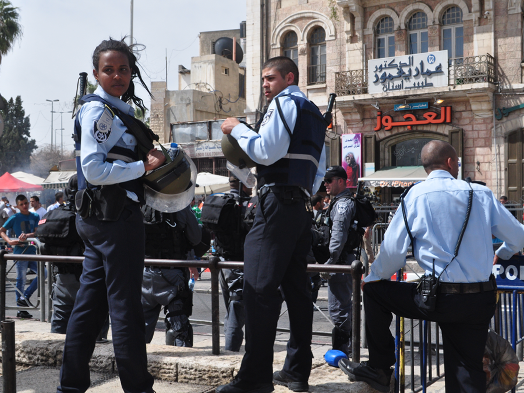
Israeli police checkpoint outside Damascus Gate. Old City, Jerusalem.
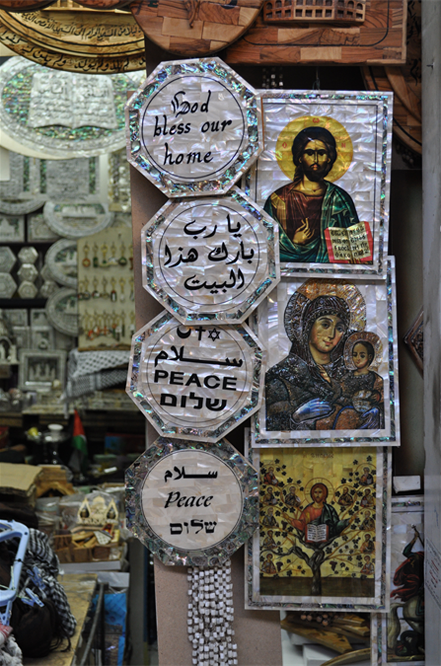
Shop selling to tourists in the Christian Quarter, Old City, East Jerusalem.
The Palestinian village of Silwan, which is located just underneath the Temple Mount/Haram al-Shariff outside the walls of the Old City, demonstrates the ways in which occupation, settlement and inequality intertwine in everyday life in East Jerusalem, and also, importantly, how Palestinian and Israeli space overlay each other in a particularly uneven configuration. Here, a settler enclave has sprung up as part of an archaeological dig: the City of David, believed to be the location of the biblical city of King David from 3000 years ago. Taking advantage of archaeology as a means to legitimize Israeli presence in occupied East Jerusalem (Abu-Haj 2007), the dig is run by the settler organization Elad who, with the support of the Israeli government, have deemed it a ‘national park’. There is in fact no way to separate the City of David from Silwan (Figure 13). The park sits in and runs through the heart of the neighbourhood, archaeological digs take place under people’s houses (resulting in the collapse of some) and a number of Palestinian residents have to cross through the park to go about their daily activities: it is not unusual, for instance, for the Israeli school groups or soldiers who visit the park as part of organized tours to run into a young girl on her way to school, or an old man carrying his shopping back from the souq. Some 400 settlers live in properties incorporated into the park by Elad and receive municipal services that the local Palestinians do not. While Silwan is one of the poorest villages in East Jerusalem, many settlers live along newly paved, well-lit streets; indeed, when settlements front onto Palestinian streets, newly-built footpaths absurdly end at the perimeter of their properties. With 80 houses in the al-Bustan neighbourhood slated for demolition to make way for the ‘King’s Garden’, which will function as a natural corridor between the settlements and West Jerusalem, it is not surprising that Silwan is one of the tensest areas of East Jerusalem. Violence flares up sporadically, especially between settler guards and local Palestinians, and stone-throwing youth frequently encounter tear gas and rubber bullets shot by border police.
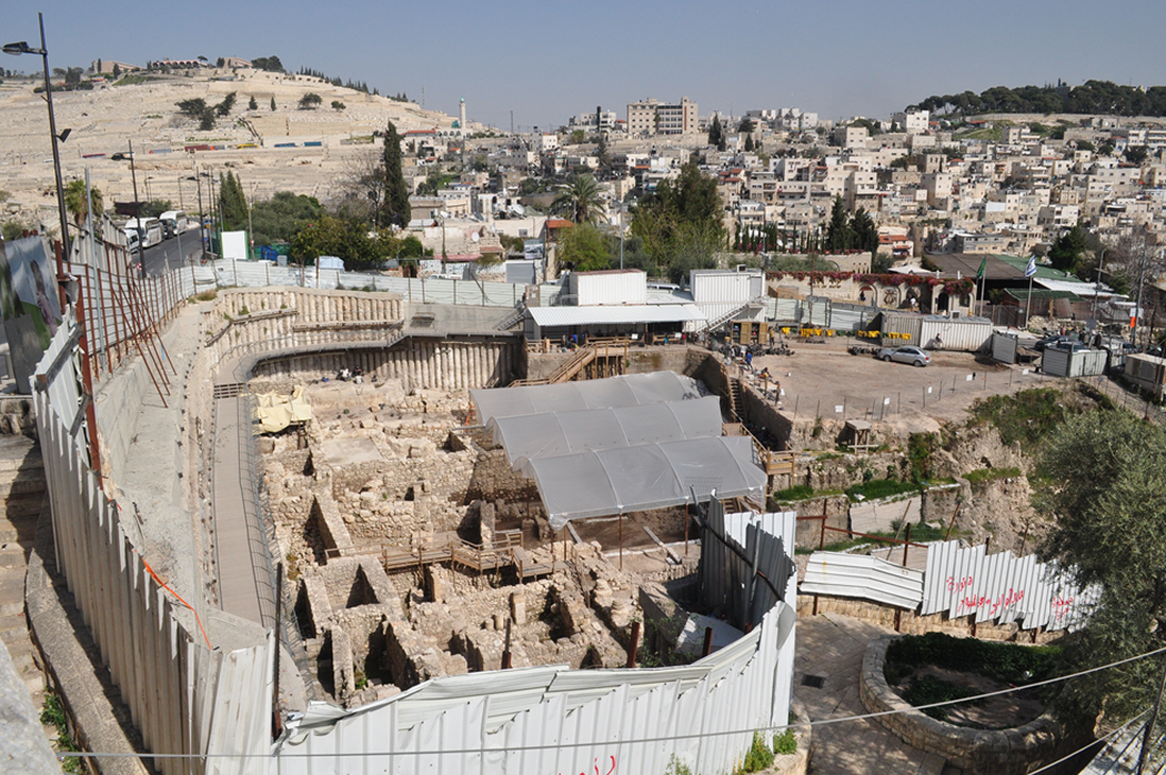
City of David archaeological park, Silwan, East Jerusalem.
Looking west
Whereas the pressures of the occupation combined with the close quarters in which Palestinians and Israeli often live make East Jerusalem a site of constant tension threatening to spill over into violence, West Jerusalem for the most part escapes the conflicts that structure daily life in the east. Public space is mostly Jewish, as is the population, and West Jerusalem has solidified itself as the internationally acceptable (as opposed to accepted) capital of the Israeli state. In many ways, West Jerusalem is a microcosm of broader Israeli society and the city is home to the same social divisions found across Israel. The city’s Ashkenazi (Eastern European), Mizrahi (Arab), Ethiopian and Russian Jewish populations remain largely segregated, frequenting ethno-specific restaurants and nightspots; the migrant worker population, too, has its own public spaces (albeit small), and one may see Nepalese or Filipinos gathering in West Jerusalem’s malls and thoroughfares to informally celebrate their own cultural events and holidays. The city’s religious significance manifests in the masses of young diaspora Jews on ‘Taglit – Birthright’ trips 10 who can be found filling its streets during the summer months, joining religious Jewry from abroad on their yearly vacations, making the distinction between ‘Jewish’ and ‘Israeli’ particularly apparent. The purchase of properties by French and American Jews in prime areas of the city, for instance, has driven up prices and made a handful of neighbourhoods populated only during summer, which has incited anger from Israeli-born Jerusalemites. However, the starkest division – and the one most dominant in West Jerusalem – is that of religious/secular (Figure 14). Jerusalem’s Jewish population is becoming increasingly religious, as the Haredi population grows significantly and secular Israelis move to satellite towns outside the city’s municipal limits (Alfasi et al. 2012). The contest between secular and religious Jews to shape public space has most recently manifested in contentions over gender-segregation on buses and the blacking out of images of women on billboards and advertisements. 11
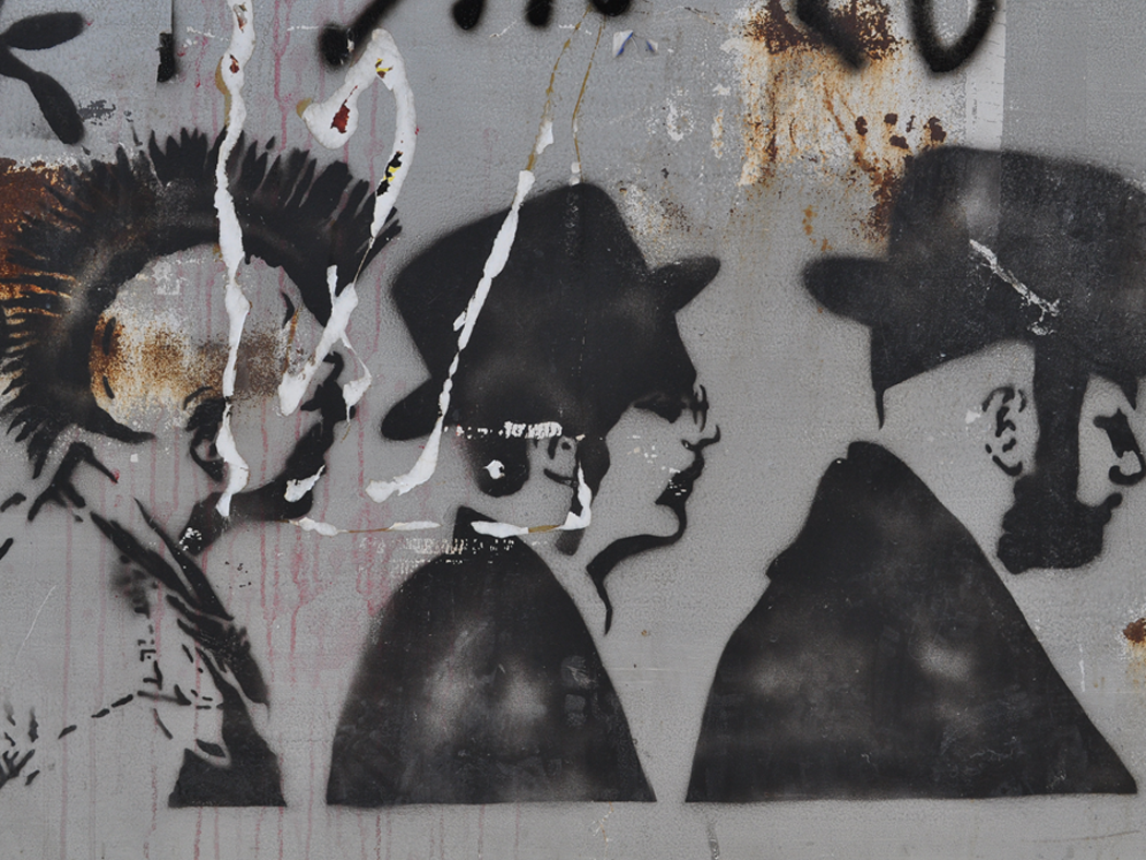
Graffiti, West Jerusalem.
While it may not be immediately evident, the conflict between Israel and the Palestinians is nevertheless present in West Jerusalem, shaping its geography and landscape as much as it does in the east. As Krystall (1998) explains, prior to 1948, the Palestinian community living in what was to become West Jerusalem numbered about 28,000 and was one of the most prosperous in the Middle East, living in often grand residences in neighbourhoods like Qatamon, Baq’a, Talbiyya and Musrara. Compared to the 95,000 strong Jewish community which owned 30 per cent of West Jerusalem lands in 1947, the ‘West Jerusalemite’ Palestinian population owned 34 per cent (excluding the Arab villages which were later incorporated into municipal limits) and typically rented to Jews living in mixed neighbourhoods. With the outbreak of war, the vast majority of West Jerusalem residents, Palestinian and Jewish, fled or were evacuated from their homes. Palestinians living in villages on the outskirts, in particular, were targeted by Jewish paramilitaries seeking to gain control over the city’s entrance on the main road to Tel Aviv. For instance, most residents of the village of Lifta – which now stands largely empty at the entrance to Jerusalem (Figure 15) – left the village after a series of attacks in late 1947, which resulted in seven deaths and a number of houses destroyed. Residents of other villages were expelled in similar ways, or fled following the infamous April 1948 massacre of civilians at Deir Yassin by the Stern Gang and Irgun paramilitary organizations. Upon the formal cessation of hostilities, Jewish residents were permitted to return to their homes in West Jerusalem; Palestinians were not and their homes were re-settled, mostly by new immigrants, but also by some Jewish families displaced from Jewish areas in East Jerusalem (such as Shimon HaTzadik). By 1948 the conflict had manifested in such a way that ‘all the neighbourhoods of Jerusalem – except for the Jewish Quarter in the otherwise Arab Old City – were exclusively Arab or Jewish, with virtually no communication between them’ (Krystall 1998: 9).

Lifta, a pre-1948 Palestinian village now located in West Jerusalem.
In addition to incorporating the vast majority of Jewish Jerusalem, with the exception of a handful of enclaves on the east side like the Hebrew University on Mount Scopus, newly-founded Israeli West Jerusalem also incorporated nine previously Arab villages and neighbourhoods into its bounds. These Palestinian histories remain present in West Jerusalem, as do many old Palestinian homes, even as they have been integrated into Israeli urban and suburban spaces. Many of the houses of Deir Yassin, for instance, were incorporated into an Israeli hospital for the mentally ill; in other places, it is not unusual to glimpse Arabic writing above a doorway or a crescent on an old iron gate. A number of the former Palestinian West Jerusalem neighbourhoods have been re-named as part of a process of Judaization – Talbiyya, for example, has formally become Komemiyut (even if it has failed to catch on) – and are highly sought-after real estate. Grand Arab residences are now marketed as Beit Aravi (in Hebrew: Arab house) by Israeli real-estaters who emphasize their authentic charm and character. 12 There are, however, a handful of sites that directly testify to their Palestinian character and which are yet to be Judaized. Lifta is one such site, and is in fact one of the few remaining Palestinian villages not demolished or re-populated with Jews after 1948. Nevertheless, Lifta’s future presently hangs in the balance, with Israeli developers seeking to turn the old Palestinian village into an exclusively Jewish luxury resort, complete with 212 housing units, a hotel, a shopping mall and open ‘green’ areas; the mosque would be converted into a synagogue, with the old houses incorporated into developments (see Busbridge in press).
Mamilla (Ma’man Allah) cemetery is another site in West Jerusalem that speaks to the Palestinian history of many of its spaces (Figure 16). Located just outside the walls of the Old City close to Jaffa Gate, Mamilla is the largest and most significant Muslim cemetery in historic Palestine, having been in use since the seventh century and believed to contain the remains of the Prophet Muhammad’s companions and warriors of Salah al-Din’s (Saladin’s) army (Makdisi 2010: 521). Since it was transferred to Israeli control in 1948, Mamilla cemetery has been progressively built over with a handful of carparks, and most significantly, Independence Park, which is the second largest park in Jerusalem. Currently, only a tiny portion of the once 50-acre-large cemetery is visible, albeit in a state of disrepair: the area is overgrown with weeds, trash is strewn between the head stones and tombs, which are themselves cracked and damaged. Controversially, a portion of Mamilla cemetery is the site of the planned Museum of Tolerance in Jerusalem, which is intended to be ‘a great landmark promoting the principles of mutual respect and social responsibility’. Since construction was first announced in 2004, it has been suspended on a number of occasions due to news breaking in 2006 that workers excavating had been discovering – and then disposing of – human remains (Makdisi 2010). Despite widespread criticism, as well as the withdrawal of various architects including Frank Gehry, who originally designed the building, construction continues today, albeit hidden behind the tall silver fence that surrounds the site and dominates what is left of Mamilla’s graves.

Mamilla cemetery, West Jerusalem. The fence at the back protects the site of the planned Museum of Tolerance.
As mentioned earlier, Palestinians are becoming increasingly more visible in West Jerusalem’s public spaces, although this presence is more transient than permanent. Whereas 200,000 Jewish Israelis live in settlements in East Jerusalem, very few Palestinians are permanent residents in West Jerusalem – and of these, the vast majority are Palestinian citizens of Israel coming from Arab towns in the north. Original Jerusalemite Palestinians remain unable to return to or claim compensation for their properties, despite a great many living only relatively short distances away in East Jerusalem or the broader West Bank. Other Palestinians who may be interested in purchasing property encounter a number of legal, bureaucratic and logistical hurdles that make it effectively impossible; 13 likewise, Jewish landlords are typically reluctant to rent to Palestinians, particularly in more conservative areas with strident anti-Arab sentiments. The Palestinians who are present are thus those who work in West Jerusalem, which is in fact one of the few options available to East Jerusalemites who encounter rampant poverty, unemployment and a severe lack of opportunities in that part of the city (see UNCTAD 2013). The vast majority are in the construction and service sectors, working variously as shop assistants, kitchen-hands, chefs, gardeners, construction workers and street cleaners (Figure 17) – thus literally engaged in the day-to-day servicing and building of West Jerusalem.
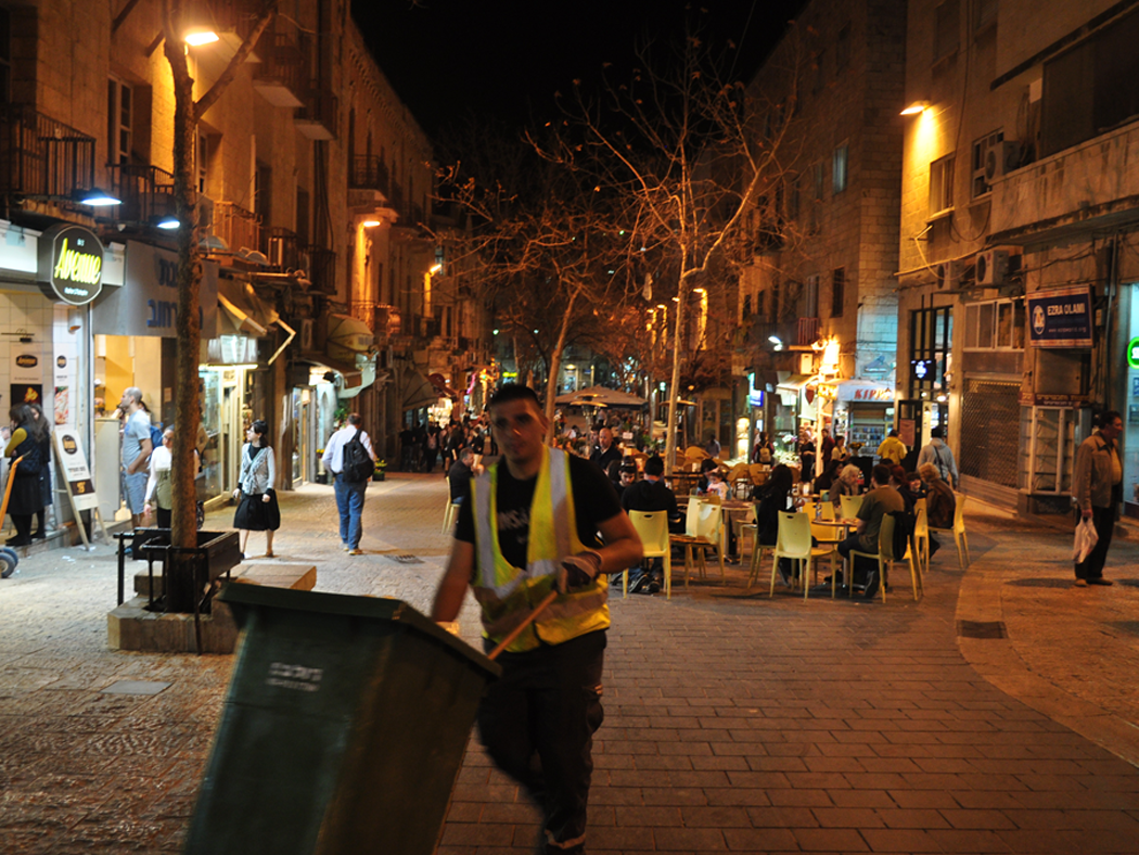
Palestinian street cleaner, Ben Yehuda mall, West Jerusalem.
Increasingly, East Jerusalemite Palestinians are opting to spend their leisure time in West Jerusalem too. This is a particularly new development, albeit one also connected to the occupation and the vast inequality that defines the east-west divide. On the one hand, the construction of the Jerusalem Light Rail, which connects Israeli settlements in the east with West Jerusalem, has made the west side of the city more accessible for Palestinians. As much as the Light Rail entrenches the occupation insofar as it enacts the Israeli claim to ‘united Jerusalem’ (it is also illegal as a measure undertaken by an occupying power to demographically-alter the territory it occupies), the train has emerged as one of a few sites of tentative coexistence unthinkable only a handful of years ago. Here, one can see Jews and Arabs sitting next to each other as equal patrons of the service, and all stops are announced in Hebrew, Arabic and English (although it is perhaps significant that many of the Arabic announcements are in fact Arabizations of Hebrew place names). On the other hand, the lack of public spaces in the east, including cultural centres and cinemas for example, means that many Palestinians choose to head to the west for leisure activities. As the west side is rendered more accessible, more and more East Jerusalemite Palestinians are entering West Jerusalem’s shopping malls and strips, restaurants and cafes as consumers; likewise, groups of young Palestinian men are increasingly choosing to congregate in parks or other public spaces in the west. The evidence of this growing Palestinian presence in the west pops up in often surprising ways, such as Palestinian-oriented graffiti, for example (Figure 18), but most stridently in terms of visible presence. While this has sometimes made for incidents of confrontation and violence, with Palestinians typically the target of assault (in 2012, for instance, three Palestinian youths were lynched by a mob of Jewish teenagers), 14 in most instances it has made for a cautiously shared public space (Figure 19).
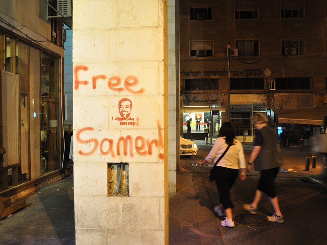
Graffiti in West Jerusalem demanding the release of the East Jerusalemite Palestinian hunger striker Samer Issawi. Issawi ended his nine month hunger strike in protest of the Israeli practice of administrative detention in April 2013.
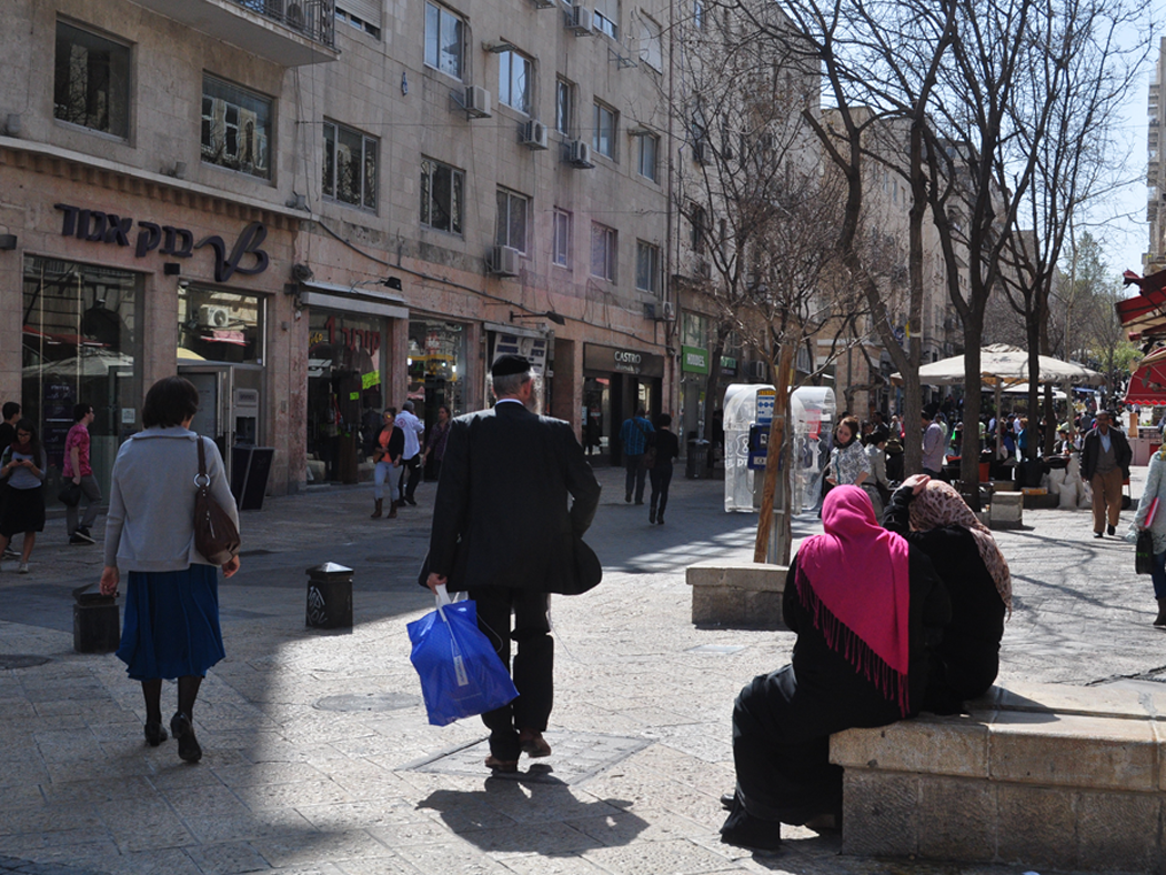
Palestinian women sitting in Ben Yehuda mall, West Jerusalem.
Re-imagining Jerusalem’s frontier
The project of re-imagining the frontier as a site of both contest and contact thus takes on a particular urgency in Jerusalem: not only because the city’s political future demands it, but also because to think only in terms of the former is to miss something important about the dynamics of the contemporary city. For me, what is most important about this task is that it compels us to examine the unforeseen and unanticipated outcomes of the settler colonial project, particularly when it comes to the question of relations between the parties respectively positioned as settler and native. The frontier, as I have sought to examine and illuminate here, is a site of conflict, contestation and dispossession, but it is also importantly that which binds the settler and native together. It is, to put it simply, the reality and hope of coexistence in settler colonial contexts, and the challenge herein is how to transform relations at the frontier. Jerusalem in this regard is particularly instructive, not least because the formal settlement project is unlikely to ever be ‘complete’, compared to, say, the settler colonial spaces of Australia and Canada where the defeat and domination of the native was achieved through the violent reality of genocide. Israeli hitnahulut (settlement), as Oren Yiftachel (1999) frames it, has not conquered Palestinian sumoud (steadfastness); instead, the two are locked in a seemingly endless battle with one other where neither is slated to emerge victorious. In contrast to the claims of ‘united Jerusalem’ or the desire to re-partition the city along ethnically pure lines, Jerusalem speaks to the unavoidable reality that not only must Israelis and Palestinians learn to live together, but that they already do. Much like the broader Israeli-Palestinian conflict, ‘east’ and ‘west’ are not only bound together in Jerusalem but are imbricated in each other. At the frontier of the city, it is thus the simple fact of presence of both Arab and Jew that compels us to think beyond the twin fantasies of ethnic separation and exclusive ownership.