
Abstract
Community wayfinding becomes more challenging with age and decrements in functioning. Given the growth in numbers of older adults, we need to understand features that facilitate or inhibit wayfinding in outdoor settings to enhance mobility and community engagement. This exploratory study of 35 short- (n = 14) and long-term (n = 21) residents in an ethnically diverse neighborhood identified relevant wayfinding factors. Data collection included an interview, map-drawing task, and walk along a previously audited, prescribed route to identify key wayfinding strategies. Most participants sought information from other people as a primary method of route planning. Street signs and landmarks were overwhelming favorites as helpful wayfinding features. When asked to recall the route following the walk, only half of participants gave completely correct directions. Findings reinforce the importance of landmarks and legible, systematic, and consistently available signage, as well as trustworthy person-to-person information sources. Findings also underscore the need for wayfinding research in diverse environments.
Community wayfinding is the everyday process whereby people orient themselves and find their way to destinations in the environment, whether on foot or by other modes of transportation (Lynch, 1960). Accordingly, wayfinding is essential to mobility, with influence on participation in community life and ultimately health and well-being (Hunter et al., 2013). Wayfinding requires that people plan a route, orient themselves, make correct turn-by-turn route decisions, remember their pathway, and recognize when they have arrived at a destination. Each step entails interaction between individuals and the environment, including design and natural features; point-of-decision aids and cues, such as street signs; and wayfinding support systems, such as street-naming and numbering conventions and signage for transit or roadway systems (Allen, 1999; Lynch, 1960). Wayfinding in familiar environments draws upon acquired knowledge and so-called “cognitive maps” (i.e., internal representations of the relevant environment) to aid in efficient and largely automatic navigation (Golledge, 1999). By contrast, wayfinding in unfamiliar environments is more challenging, requiring the individual to learn new routes, drawing upon aids, such as written directions, and environmental cues, such as landmarks. Consequences of poor wayfinding include increased risk of getting confused, compromising safety of self or others, and the possibility of getting lost or becoming isolated as mobility becomes restricted (Chiu et al., 2004; Lamont, Kenyon, & Lyons, 2013; Uc, Rizzo, Anderson, Shi, & Dawson, 2004; Wood et al., 2009).
Research suggests that wayfinding, a highly complex spatial navigation task, becomes more difficult as people age (Head & Isom, 2010; Klencklen, Despres, & Dufour, 2012; Moffat, 2009). Age-related decrements in vision, movement, and especially cognition may affect personal capacity for wayfinding and the ease with which individuals can make use of aids and cues in the environment to successfully navigate to and from destinations (Iaria, Palermo, Committeri, & Barton, 2009; Moffat, 2009; Owsley & McGwin, 2004; Wiener, Kmecova, & de Condappa, 2012). Relevant visual decrements include diminished static and dynamic visual acuity, sensitivity to glare and light, and useful field of view, whereas changes in movement are influenced by diminished lower extremity strength, as well as vestibular and proprioceptive changes (Moffat, 2009).
Age-related changes in cognitive function (i.e., cognitive aging) is a significant factor in alterations in older adult wayfinding performance, including orientation and navigation (Bates & Wolbers, 2014). To date, research has primarily been conducted in virtual environments, more recently with neuroimaging that has illuminated differences in brain activation between older and younger subjects in wayfinding tasks (Moffat, 2009). Whatever the underlying mechanism, declines in cognition can affect attention and working memory, in turn limiting recognition or recollection of landmarks that provide vital wayfinding cues, especially at decision points and for orientation (Omer & Goldblatt, 2007; Waller & Lippa, 2007). Changes in cognition may also influence capacity to form or interpret maps, link landmarks and other features to body turns, or follow a route (Bates & Wolbers, 2014; Jheng & Pai, 2009; Liu, Levy, Barton, & Iaria, 2011; Sheehan, Burton, & Mitchell, 2006; Simon, Walsh, Regnier, & Krauss, 1992; Wiener et al., 2012). In older adults, the cognitive demands of wayfinding may compete with sensorimotor demands while walking or the need to divide attention among multiple task areas while driving (Lovden, Schellenbach, Grossman-Hutter, Kruger, & Lindenberger, 2005; Wood et al., 2009).
Older adults are known to use different strategies than their younger counterparts while wayfinding. Older adults are more likely to employ egocentric approaches (i.e., approaches in which objects or locations in the environment are defined in terms of the self, for example, “behind or in front of me”; Rodgers, Sindone, & Moffat, 2012; Wiener, de Condappa, Harris, & Wolbers, 2013) and to rely on the advice of others (Fuchsberger et al., 2012). While such findings stem largely from virtual environment research, older adult self-reports also shed some light on strategy preferences. For example, older motorists often avoid unfamiliar routes and busy roadways where there is pressure for quick decisions with potentially bad consequences from missing a turn (Burns, 1999; Molnar et al., 2013). Older Dutch pedestrians revealed preferences for main routes and few turns, as well as a dislike of limited sight distances (Borst et al., 2009).
Our population’s aging is accompanied by an increase in individuals with chronic disease and age-related functional impairment who are more adversely affected by environmental challenges than other groups (Kochtitzky, 2011). Recently, Phillips, Walford, Hockey, Foreman, and Lewis (2013) called attention to the particular challenges of wayfinding in unfamiliar environments, noting that older adults have difficulty with poor signage, the absence of information pertaining to distance, and noisy or chaotic spaces. Other research highlights the importance of maintaining capacity with age, finding that strong spatial ability in older adults predicted neighborhood use, as measured by number of services used, total distance of unique trips, and average trip length (Simon et al., 1992).
We note that while some studies have been conducted with older adults in real world settings such as supermarkets, or in automobiles, few have been conducted outdoors in pedestrian wayfinding situations. Outdoor wayfinding, by definition, involves physical movement through space with numerous distractions and competing demands, conditions that are difficult to simulate in virtual environments where most research to date has been conducted. There are other factors that may have relevance to community wayfinding but have not been extensively tested, including (a) the relationship between the amount of one’s exposure to the specific environment and wayfinding self-efficacy, and (b) strategies and tools used by older adults in wayfinding. We might expect that exposure to the environment would augment environmental knowledge and wayfinding confidence or self-efficacy. One study has shown that environmental exposure via walking has been associated with walking self-efficacy in older adults (Mullen, McAuley, Satariano, Kealey, & Prohaska, 2012). Wayfinding tools such as maps or route navigation applications have been shown to facilitate wayfinding in adults with sensory or cognitive limitations (Vainio, 2011), but little is known about the extent to which older adults actually use such wayfinding tools or alternative strategies such as seeking information from other people.
The purpose of the current exploratory research was to identify the strategies and wayfinding aids and cues preferred and utilized by a community of ethnically diverse older adults, including both long- and short-term residents and those with and without a modest degree of cognitive limitation. Addressing the relative absence of studies of older adult wayfinding in outdoor settings, we also sought to generate hypotheses for future community-based research to better inform our understanding of outdoor wayfinding.
Method
We employed an integrated mixed methods approach, including neighborhood audit, in-person interviews, and community walks, in a geographic area where environmental wayfinding supports had previously been audited. The Institutional Review Board of the University of Illinois at Chicago approved all procedures.
Setting
The study took place in southeast Chicago in the community known as South Chicago, an area of low socioeconomic status with documented health disparities (Giachello et al., 2003). A diverse community consisting primarily of African Americans (72%) and Latinos (26%; Yonek & Hasnain-Wynia, 2011), South Chicago is bordered by Lake Michigan to the east, South Chicago Avenue to the west, 79th Street to the north, and 95th Street to the south.
Participants
We recruited a convenience sample of community dwelling adults, aged 65 or older, from independent living residences, community centers, and senior centers in South Chicago. Inclusion criteria included walking or wheeling independently in the community at least once a week, English language proficiency, and residence in the community for at least 1 year with no address change in the previous 6 months. We recruited persons both with and without self-reported memory problems, excluding those who were dependent on a caregiver who helped make decisions or manage daily activities (as a proxy for moderate to severe cognitive impairment). Exclusion criteria included myocardial infarction or unstable angina in the last 3 months, uncontrolled cardiovascular disease or diabetes mellitus, severe chronic obstructive pulmonary disease (COPD), recent healing or unhealed fracture, and hip or knee replacement in the past 6 months. Participants were compensated with US$75 for their participation in the study.
Procedures
There were two main procedural components, a preliminary neighborhood audit by trained auditors that was previously conducted, and the current participant session consisting of an interview, map-drawing task, and researcher accompanied walk. These components are described below.
Preliminary neighborhood audit
In summer 2011, research team members using the Centers for Disease Control and Prevention (CDC) Healthy Aging Research Network Environmental Audit Tool (Kealey et al., 2005) conducted a walking audit of selected residential and commercial areas known to be traversed by older adults in South Chicago. The tool provides data on the quality of the built environment from the perspective of older adults, including those with chronic disease or functional impairments. Using the tool, wayfinding aids, cues, and barriers for neighborhood street segments were systematically documented, along with factors related to safety, accessibility, comfort, appeal, land use, and availability of destinations. On the basis of audit data, street segments were rated as either high or low relative to the presence of wayfinding aids and cues. Segments characterized as “high” wayfinding included at a minimum legible street name signs, one or more landmarks, good visibility (being able to see not only immediate surroundings, but also vehicles, other people, signs, landmarks, and intersections in the distance), and an absence of barriers to accessibility. Segments characterized as “low” wayfinding were monotonous and/or missing a critical decision aid, such as a street name sign. These data were subsequently employed to identify a route for the participant walk (see below).
Interviews
Participants took part in face-to-face interviews of approximately 45 min duration at a senior center to explore their approach to and perceived self-efficacy for wayfinding in both familiar and unfamiliar surroundings. The interview included structured items, specifically demographic data, length of residence, use of personal and public transportation, health and functional status, usual physical activity, destination and leisure walking, social isolation/engagement, mobility, and self-efficacy for wayfinding. Semistructured and open-ended items elicited individual route planning and recollection and decision-making strategies, whether walking, driving, or traveling via public transportation. Interviewers recorded responses on an iPad or audio recorder.
Map drawing
To get a sense of participants’ perception of the community and environmental knowledge, each participant was asked to draw a map of South Chicago, “marking places you go and landmarks that are important to you.” When they had completed their maps, interviewers asked participants to explain their drawings. We audio recorded the responses and subsequently categorized the drawn maps as either route or survey maps, also noting the richness or complexity of their features. All drawings were reviewed by two reviewers and any differences resolved via discussion and consensus.
Walks
A graduate research assistant, supported by a lay research assistant well known in the neighborhood, accompanied each participant on a walk between the same two specific locations. To help decrease the potential for fatigue, we conducted the study in the mornings, before the weather was hot, and before the other activities of the day had a chance to fatigue the participants. Also, the community research assistant carried a portable chair in case the participant needed to take a break.
Using neighborhood audit results previously collected, we chose a route (Figure 1) of nine blocks round trip (a reasonable walking distance for older adults), with sections including both high and low wayfinding cue/aid availability, and absent of any conditions that would be dangerous to pedestrians. Directions were given as follows: “We are going on a short walk now. I will guide you, but I want you to pay attention so that you would be able to give directions to a friend who is unfamiliar with the area.” Participants were neither told their destination nor asked to find their way to the destination. Instead, they were guided on the walk. The experience was similar to what one would have in walking along with a friend to a new place while expecting to have to find your way back to the origin on your own, or to tell someone else how to meet you at the destination following the route you just traversed. Thus, to give the directions, they would have to recall the route that they took to get to their location. The purpose of the exercise was to solicit information about aids, cues, and strategies used by participants in wayfinding, and to ascertain what features they deemed most important in advising a friend to traverse the same route they had just traveled.

Navigational route walk.
Along the route, while the participant was stopped, the interviewer used prompts to elicit information about orientation, barriers, facilitators, and other factors of interest, such as boundary and landmark identification and strategies for decision making. At the end of the route, participants were asked to share the directions they would give to their friend (route recall). Participant responses were recorded. Each walk lasted approximately 45 min, a time considered long enough to gain the needed information, but not too long to fatigue older participants.
Data and Analysis
Measures
Personal characteristics
In addition to sociodemographic factors, we examined walking and other transportation-related behaviors and self-efficacy for walking and for wayfinding, all collected via participant self-report in the interview. Basic sociodemographic data were collected in the interview, and self-efficacy measures were selected from the Healthy Aging Research Network Walking Study protocol, in which degree of confidence was self-rated on a scale of 1 (not at all confident) to 10 (completely confident; Mullen et al., 2012).
Outcomes: route recall and orientation
Orientation was assessed via three queries over the course of the walk that required participants to locate themselves relative to a direction (e.g., North), or to another location (e.g., Commercial Avenue). They were also asked how they made the determination. Route recall was determined by participant recitation of “directions for a friend” upon arrival at the walk destination.
Environmental characteristics, strategies, and cues
Participants were queried about environmental characteristics, strategies, and cues used in route planning and en route travel and decision making. The research team subsequently categorized responses to open-ended queries. Identified categories of interest included universal and neighborhood-specific landmarks, street signs, land use, stores/businesses, transit stops, safety-related features, and idiosyncratic features.
Data Coding, Management, and Analysis
The protocol included several semistructured and open-ended questions that required coding after listening to audio-recorded responses. To address this need, we developed and tested a coding questionnaire, with all research team members coding a record and subsequently cross-checking and discussing to reach consensus and to ensure consistency across coders. We then listened to and coded files independently into a Survey Monkey database. Coder discrepancies were resolved, and coded data were exported to an SPSS (version 19) database for further analysis.
Given the exploratory nature of the study, data analysis was largely descriptive, including frequencies, cross-tabulations, and other descriptive measures. Data from the walk and interview were summarized to describe participant characteristics likely to influence wayfinding and preferred wayfinding strategies. Data from all five sources of information (i.e., participant screening, walk, map drawing, and both sections of the interview) were used to identify possible relationships between participants’ personal characteristics, environmental features, and correctness of route recall or orientation. Semistructured and open-ended responses were assessed with regard to commonalities and differences in participant perceptions and for recurrent themes. Pearson’s chi-square tests were used to test the independence of categorical variables, whereas means were used for continuous variables.
Results
Participant Characteristics
Of 43 older adults screened for the study, 8 were excluded based on residency, dependence on a caregiver, medical status, or lack of English proficiency. Table 1 presents characteristics of the 35 participants included. Fifteen were male and 20 female, with a mean age of 70.6 (±5.6) years. A total of 68.6% of participants self-identified as African American, 17.1% Latino, 8.6% White, and 5.7% Other. Ten of the 35 participants were reliant upon mobility aids (5 canes, 2 walkers, 1 wheelchair, 2 multiple aids). More than half of participants considered themselves low income; nearly two thirds had at least a high school education. Twenty-one participants were considered long-term residents, having lived in South Chicago for more than 4 years; remaining participants were short-term residents. Eleven participants were classified as having some minor cognitive limitations based on positive results from at least two of the following: the Mini-Cog measure (n = 9), self-reports of problems with memory (n = 7), or interviewer observations, that is, difficulty maintaining attention, staying on topic, or comprehending questions (n = 7; note that the groups were not mutually exclusive).
Characteristics of the Sample.

Participants’ physical activity engagement was well below the recommended level of 150 min per week of moderate intensity physical activity for older adults (U.S. Department of Health and Human Services [USDHHS], 2008), but on average participants walked or wheeled in the community 3.1 days per week. They predominately used public transit as opposed to private automobile. Among them, 71.4% rode a train or bus more than twice a month, while 45.7% never drove, and an additional 5.7% drove only once or twice a month. Wayfinding self-efficacy scores (confidence in ability to find one’s way under different circumstances) were consistently very high with mean scores of 9.9 and 8.6 on a scale of 1 to 10 (Table 1). This confidence was further reflected in responses to open-ended queries in the interview.
Wayfinding Strategies, Aids, and Cues
In interviews, participants identified sources of information for planning routes, how they choose the best route (for walking, public transportation, or driving), and the most helpful environmental wayfinding features. Table 2 summarizes their responses. More than 94% of participants indicated seeking information from others as a primary method of route planning (e.g., friends, someone at the location to be visited, or professionals such as transit officials). Police and transit staff were highly regarded information sources. Other participants explored on their own (31.4%), used maps (22.8%), or looked up directions (17.1%). Only two individuals reported using a vehicular global positioning system (GPS) or a mobile phone. Criteria for choosing the best route varied by participant, with some favoring speed, others directness of route or familiarity, and still others safety. Street signs (80.0%) and landmarks (77.1%) were overwhelming favorites as helpful wayfinding features, followed by numbers on buildings (48.6%), people to ask (37.1%), block numbers (25.7%), and advance street signs (signs that state which streets are upcoming; 8.6%).
Route Planning, Decision Making, and Environmental Facilitators.
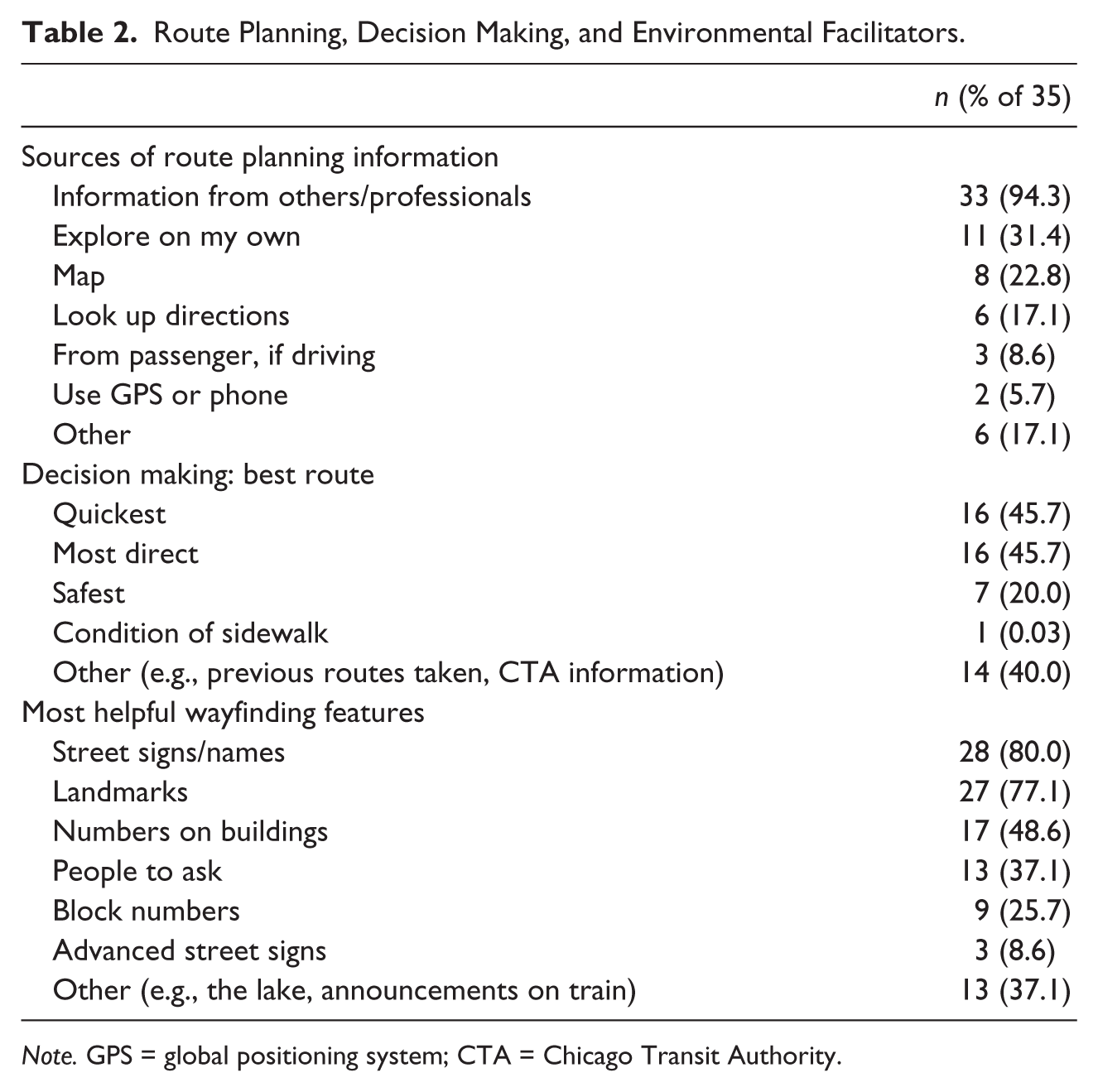
Note. GPS = global positioning system; CTA = Chicago Transit Authority.
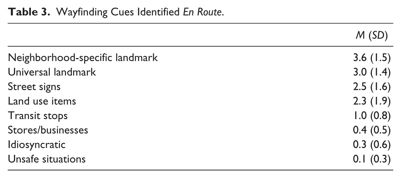
During the walk, participants identified environmental characteristics en route that they viewed as important to wayfinding. We classified their responses as universal landmarks (distinctive buildings or other features that anyone would notice, e.g., churches with a visually prominent steeple), neighborhood-specific landmarks (structures or other elements lacking distinctive feature that would be salient to a resident but would likely go unnoticed by nonresidents, for example, a place where a community event takes place), street name signs, land use items (e.g., railroad tracks), transit stops, idiosyncratic landmarks meaningful to an individual (e.g., house where I was born), and places where safety is a concern. Overall, landmarks (universal or neighborhood-specific) were the most frequently cited cues, followed by street signs, land use items, transit stops, stores/businesses, idiosyncratic cues, and safety issues (see Table 3).
Wayfinding Cues Identified En Route.
We additionally calculated cross-tabulations between the wayfinding cues identified en route (described above) and the individual participant characteristics, including length of residence (short- or long-term status), cognitive status (limitation or no limitation), perceived health (fair/good or very good/excellent), self-efficacy (low or high self-efficacy), amount of walking/exercise (<150 min per week or ≥150 min per week), and various special needs (e.g., problems with vision or not) to look for statistically significant associations. Only 3 of 104 comparisons were statistically significant (based on chi-square analysis and p < .05), and no more than one for any participant characteristic; thus, results are not reported here.
In open-ended queries, participants identified many barriers or confusing situations when wayfinding in a new place. Lack of familiarity was a basic issue, complicated by difficulty in judging distance, knowing when the destination was reached, and not yet knowing area landmarks. Places with “no good landmarks or missing signs” were seen as problematic. Some participants identified distractions (e.g., ringing phones, noise of train) and/or pressures (“impatient drivers behind you”) as contributors to wayfinding confusion. Others called attention to confusing street alignments, such as angled streets or intersections and dead ends. An additional barrier was a concern about which strangers could be safely asked for help: as one participant said, “[You] can’t ask just anybody.”
Participants shared preferred cues and strategies for keeping track and remembering the way back to their point of origin. Cues included landmarks (“to know where to turn”), smells, and other memorable features. As one person remarked, “I mark ‘spots’ to remember to come back that way; Look for signs, look for stores, look for something so you know you’re coming back the same way.”
Several participants referenced the logical street labeling system and the importance of being aware of cardinal directions and where streets are located in relationship to one another. With this knowledge, as one participant said, “I can go back a different way if I want to . . . it doesn’t matter.” Still others talked about the importance of committing the route to memory, for example, “I’m like an elephant—I don’t forget. I use my mind.” Others remarked on the need to write everything down to aid memory or if driving, to use GPS.
Orientation and Route Recall
Correct orientation and route recall were assessed in the walk. Orientation was considered correct if participants answered each of three orientation questions correctly. Eighty percent of participants gave correct orientation responses each time they were queried. Lake Michigan, the eastern boundary of the neighborhood, was identified as an important orientation support along with sun location and the Chicago street labeling conventions that provide information about direction and distance from a central point. For route recall, as determined by correct recitation of “directions for a friend,” just over half (51.4%) of participants gave completely correct directions. Of all the personal characteristics in Table 1, only limited versus unlimited vision (p = .02) appeared to affect the ability to accurately recall the route.
Wayfinding performance is likely to be facilitated by environmental knowledge, whether knowledge of the specific neighborhood or the underlying principles of the wayfinding system. In the map-drawing task, 16 participants created route maps and 19 participants created more complex survey maps providing more of a “bird’s-eye view” of the neighborhood. Almost all participants (n = 31, 88.6%) included landmarks or street names (n = 29, 82.9%), while few included blocks or other indicators of distance (n = 7, 20.0%) or boundaries (n = 5, 14.3%).
Safety and vulnerability are themes that arose throughout the interview queries, but only for some individuals. Safety was highlighted in different ways by different individuals (e.g., fear of crime, threatening people, teens, traffic, or dangerous sidewalks).
Discussion
The current findings provide a starting point for a closer look at community wayfinding supports with the long-term goal of identifying essential wayfinding elements that would facilitate older adult mobility and community engagement across the spectrum of function. Our findings reinforce previous work emphasizing the complexity of landmark use in older adult wayfinding (Lipman, 1991), especially highlighting the role of landmarks as orientation and associative cues and in providing a frame of reference (Chan, Baumann, Bellgrove, & Mattingley, 2012). For example, participants frequently referenced nearby Lake Michigan for orientation and for providing a general understanding of the geometry of the area. Both universal and neighborhood-specific landmarks were viewed as important in monitoring route progress and in aiding directional decisions. Participants consistently identified the same places as neighborhood-specific landmarks, for example, a local family-owned bar/restaurant. Other participants referenced landmark features that were completely specific to an individual, such as “the house where I was born.”
This raises the issue of how to best use this information to promote ease of wayfinding (Evans, Brennan, Skorpanich, & Held, 1984; Lipman, 1991). In monotonous areas without distinctive buildings, green spaces, or natural features, communities might consider investing in street art or encouraging property owners to distinguish their property in some way. Another strategy advocated is to include landmarks in paper, online, and streetside maps, with key landmarks depicted in directional signage as well. Such strategies might especially benefit visitors. Our findings, however, highlight the extensive use by residents of neighborhood-specific landmarks that would likely not be salient to outsiders. Additional research is needed to investigate the relative importance of universal and neighborhood-specific landmarks to older adults, as well as the impact on wayfinding as neighborhood-specific landmarks, such as older buildings, are replaced or modified.
Another striking finding was the degree of participant reliance on the advice of others as the foremost strategy for new-destination route planning. Reliance on the advice of others has been reported elsewhere (Fuchsberger et al., 2012), but not to the great extent reported in our study. Our participants viewed transit officials and police as trusted sources of information and also relied on the advice of friends and family and people at destinations to be visited. This reliance speaks to the need to continue to ensure person-to-person assistance as part of increasingly complex wayfinding systems.
Exploring on one’s own was the next most prominent strategy, with looking up directions and using a map less frequently cited. Whereas participants used maps and other print wayfinding materials, few used personal navigation technology, for example, smartphones or vehicular GPS. With the increasing availability of such devices, research into their role in older adult wayfinding is needed.
In discussing the most helpful wayfinding features, whether walking, taking public transportation, or driving, participants also referenced the importance of street name signs to find their way. We were struck by the high degree of confidence of South Chicago participants in not only wayfinding in the neighborhood, but also in venturing into other parts of metropolitan Chicago. Several participants were able to describe, with precision, how to get to an address they had never visited before, simply by drawing upon the very logical and transparent Chicago street-naming system. As one participant stated, “It’s a problem if you don’t know your streets.” In general, results indicate a community environment that supports older adult wayfinding via a transparent, logical, and consistently applied system.
We anticipated differences in wayfinding based on length of residence, cognitive status, and/or extent of walking within the community. However, our results do not support such distinctions, most likely as a consequence of our small sample size. Any effects of length of residence may have been negated by the transparency of the street-naming system. Also, “cognitive limitations” were not clinically diagnosed, and people with caretakers were excluded; thus, the differences in cognition between participants with and without “cognitive limitations” were likely not substantial. Further research is needed in these areas.
Limitations
Despite the innovative nature of this exploratory study, there are some limitations to be noted in addition to the small number of participants. This study was conducted in Chicago, a city organized on a grid with a logical and consistently applied system of naming streets. As such, it offers a relatively predictable wayfinding environment that helps travelers readily understand where they are and the direction in which they are moving. Findings regarding older adult wayfinding are likely to differ in communities with street-naming and numbering conventions that are less transparent or in communities without a grid-based organization. Moreover, we only used one walk route, and the use of other routes might have yielded different results. Related, our route did not have a large range of high and low wayfinding cue/aid visibility. It would be useful for future studies to conduct multiple walks in very different environments.
In our study, we do not have interrater reliability coefficients to report. However, when coding discrepancies arose, the coders involved discussed the discrepancy and then agreed upon a code. Also, our strategies for identifying participants with mild cognitive impairment were somewhat crude, and that may be one reason why we did not find any differences between identified participants and the larger group.
Given that only 51.4% of participants were able to accurately describe “for a friend,” the route traversed in the walk, the measure may not be the best appraisal of recall. We chose to ask many questions of participants along the way, and it may be that these were sufficiently distracting to make it difficult to remember the details of the route. It is also possible that fatigue was an issue for some participants; however, we did not observe fatigue and never had occasion to use the portable chair that we always carried should a participant tire. A better measure of route recall might be for participants to lead the way back along the route.
As noted above, this manuscript was intended as an exploratory, descriptive analysis. Although we did perform statistical tests, we lack the statistical power to have confidence that null findings (which are generally what we found) are true nulls. Understanding the relationship between personal characteristics, environmental features, and correctness of route recollection or orientation is viewed as a critical area for further research.
Conclusion
Supportive wayfinding environments are likely to help enable all older adults, regardless of their functional or sensory status, to remain mobile and engaged in the life of their communities for the longest possible time. Hence, it is important that we continue to gain greater insight into older adult wayfinding-related preferences and strategies, as well as optimal wayfinding features and environmental barriers or hazards that might be remedied. Our findings reinforce the importance of landmarks and legible, systematic, and consistently available signage, as well continued provision of person-to-person information assistance. Findings also point to the need for research in diverse communities and environments, assessment of strategies to reduce sources of confusion in the built environment, and the use of wayfinding aids.
Footnotes
Acknowledgements
The authors gratefully acknowledge the contributions of Angela Hurlock and Kate Graham of Claretian Associates, Crystal Rosales of The Victory Centre in South Chicago, Rich Melendrez of the South Chicago Neighborhood House, and Joel Jacinto, community research assistant.
Authors’ Note
The findings and conclusions in this article are those of the authors and do not necessarily represent the official position of the Centers for Disease Control and Prevention (CDC) or the National Association of Chronic Disease Directors (NACDD).
Declaration of Conflicting Interests
The authors declared no potential conflicts of interest with respect to the research, authorship, and/or publication of this article.
Funding
The authors disclosed receipt of the following financial support for the research, authorship, and/or publication of this article: This publication was supported by Grant/Cooperative Agreement U58DP002759-02 from the Centers for Disease Control and Prevention (CDC). Contractor acknowledges the contribution of the National Association of Chronic Disease Directors (NACDD) to this publication. Its contents are solely the responsibility of the authors and do not necessarily reflect the view of the CDC or NACDD. The project was conducted in collaboration with the CDC Healthy Aging Research Network (HAN). The HAN is a Prevention Research Centers program funded by the CDC Healthy Aging Program. Efforts were supported in part by cooperative agreements from CDC’s Prevention Research Centers Program: U48-DP-001911, 001936, 001938, and 001944.