
Abstract
We introduce a dataset that focuses on the delimitation of interstate borders under international law—the International Border Agreements Dataset (IBAD). This dataset contains information on the agents involved in (e.g. states, third-parties, and colonial powers), methods used during (e.g. negotiation, mediation, arbitration, adjudication, administrative decrees, post-war conferences, and plebiscites), and outcomes of (e.g. full and intermediate agreements) the border settlement process during the period 1816–2001. Our focus on international legal agreements and the process that produces them makes the IBAD valuable for those that study not only territorial conflict, but also international conflict, cooperation, law, and conflict management.
Keywords
Border settlement—that is, the agreement by neighboring states on the delimitation of their mutual land borders under international law—fundamentally changes the relationship between neighboring states (Gibler, 2012; Owsiak, 2012, 2013; Owsiak and Rider, 2013). 1 This suggests that de jure border settlement constitutes a watershed moment. The question therefore becomes: how do neighbors reach de jure border settlement? To help answer this question, our article introduces the International Border Agreement Dataset (IBAD). This dataset captures information for the period 1816–2001 on the agents involved in the border settlement process (including colonial powers and third parties), the methods used by these agents as they pursue settlement (including negotiation, mediation, arbitration, adjudication, post-war conferences, plebiscites, internal/administrative decrees, and force), and the outcomes of these agents’ efforts (including both full settlement and low(er)-level cooperative agreements).
The IBAD offers two broad contributions. First and foremost, it provides insight into how states manage one of their most contentious security issues: the delimitation of sovereign jurisdictions. The data therefore have clear applications to the study of territorial conflict, but also connect this subfield to the broader study of interstate cooperation and conflict management (e.g. negotiation or mediation). In addition, because the data contain details on colonial states’ involvement in de jure border settlement and because de jure border settlement occurs via interstate treaties, the IBAD might also be used to study asymmetric relationships, the systemic effects of major (i.e. colonial) power behavior, and the effectiveness of international law. We therefore suspect our data will be valuable to a wide array of scholars and policy-makers.
Second, the IBAD directly operationalizes a concept of increasing importance to those studying interstate conflict: border settlement. Many scholars interested in border settlement currently approach the topic indirectly. 2 Rather than asking what constitutes agreement upon interstate border delimitation, they instead rely upon evidence of its rejection—usually in the form of militarized disputes (e.g. Schultz, 2014; Vasquez, 2009) or territorial claims (e.g. Huth, 1996; Huth and Allee, 2002; Simmons, 2005). This, however, can be problematic. Most territorial disagreements do not involve military action, even when actors advance an official territorial claim (Hensel, 2001; Hensel et al., 2008). Moreover, territorial claims and unsettled borders are not synonymous. Dyads with unsettled borders need not have a claim (e.g. Kenya–Sudan or India–Bhutan), while those with settled borders may still subsequently raise territorial claims (e.g. Ecuador–Peru or China–Vietnam).
In sharp contrast, the IBAD concerns states’ explicit agreement upon border delimitations, regardless of claims and dispute behavior. This avoids the difficulties noted above and offers an operationalization of border settlement that directly captures the concept that scholars seek to study. Furthermore, by providing a measure of territorial threat grounded in international law but not in territorial claims, our dataset offers two additional advantages. First, it supplies a measure of “latent territorial threat” that might be used to investigate various research questions. Borders that remain un-delimited serve as fault lines at high risk of conflict. These latent threats may not always lead to claims or militarized behavior, but they separate places at higher risk of conflict (unsettled borders) from those at lower risk (settled borders). Second, the data allow researchers to examine whether a territorial claim or the context within which the claim occurs (i.e. existence of a legal settlement or not) most affects behavior (Most and Starr, 1989). The data therefore provide an opportunity not only to examine new topics (e.g. how de jure border settlement occurs), but also to revisit well-developed research programs (e.g. on territorial claims) and gain additional insight from them.
Conceptualizing and operationalizing border settlement
De jure border settlement exists when neighboring states agree upon their respective sovereign (land) jurisdictions under international law (Cukwurah, 1967; Gibler, 2012; Owsiak, 2012; Prescott and Triggs, 2008; Vasquez, 2009). This suggests that de jure settlement possesses three broad characteristics. First, settlement requires international border agreements. We have therefore gathered comprehensive data on such agreements, with particular attention to three noteworthy characteristics: agents, methods, and outcomes.
Agents denote the actors working toward agreement, as well as on whose behalf they do so. In most cases, neighboring states negotiate and sign such agreements on their own behalf (e.g. United Arab Emirates and Oman) or explicitly delegate their authority to a third party (e.g. the International Court of Justice or the Swiss Federal Council in the Colombia–Venezuela case). Two exceptions exist, however. First, colonial powers might negotiate or administratively determine borders on behalf of their dependent territories, producing border delimitations both across (e.g. the Berlin Conference of 1884) and within (e.g. Spanish viceroyalties in the Americas) colonial empires. Second, post-war conferences allow victorious states to impose new boundaries on the international system (e.g. Czechoslovakia’s emergence after the First World War). Our data capture the activities of each of these agents.
Methods concern the tools (or conflict management strategies) that agents use when working toward border delimitation. We capture data on eight of the most prominent strategies used in the delimitation process: (a) negotiation; (b) mediation; (c) arbitration; (d) adjudication; (e) post-war conference; (f) plebiscite; (g) internal (or administrative) decree; and (h) the use of force. 3 Two characteristics are worth mentioning about the use of these strategies. First, full border settlement rarely results from a single conflict management attempt. Only 29 of the 281 dyads (or 10.32%) in our dataset experience only one conflict management attempt concerning the delimitation of their border. Many of these 29 dyads, however, are anomalous; 11 settlements occur prior to 1914 in Europe (when missing data is higher; see below) and another eight occur during the post-First (1918) and Second World War (1945) periods (when major powers redrew the map). Second, the majority of dyads (60.85%) use more than one type of conflict management strategy during the settlement process (e.g. negotiation and mediation, rather than only negotiation). Thus, the border settlement process varies substantially across dyads.
Finally, outcomes refer to the products (if any) that result from settlement efforts. Outcomes fall into one of four categories: full settlement agreements, partial settlement agreements, post-settlement agreements, and no product. Full settlements exist when neighboring states have signed (an) international agreement(s) that delimit(s) the entirety of their mutual border(s). 4 Four considerations determine whether full settlement exists empirically. First, if a series of agreements each delimits segments of a border (e.g. see Afghanistan–Iran), then the border becomes fully settled after states sign the final agreement. Second, post-colonial states inherit the borders delimited by colonial powers if they exist (e.g. see Burkina Faso–Togo)—unless they contest those borders within the first year after independence. If contestation occurs (e.g. see Ghana–Ivory Coast) or colonial powers never delimited a border (e.g. see India–Bhutan), the border remains unsettled until the involved states sign an agreement. This reconciles the competing norms of uti possidetis (i.e. new states inherit the borders of the previous state to which they belonged) and self-determination (i.e. the right of groups to select the sovereign state to which they belong). Third, border settlement does not exist if one dyad member explicitly fails to ratify an agreement that requires ratification (e.g. see Honduras and El Salvador). Lastly, border settlement—as part of international law—is irreversible, even if a state abrogates an agreement (e.g. see Ecuador–Peru) or leaves and re-enters the international system (e.g. European states during the Second World War). 5
The remaining outcomes exist relative to de jure full settlements. Agreements short of full settlement constitute “partial” settlements (i.e. low-level cooperation). These agreements include: agreements to arbitrate that the signatories may not execute (e.g. Colombia–Venezuela); treaties of friendship or alliance that delay a final border delimitation (e.g. Colombia–Peru); modus vivendi that define a temporary status quo until final border delimitation occurs (e.g. Argentina–Bolivia); or agreements obtained via third parties that the disputants reject (e.g. Spanish arbitration in Colombia–Venezuela; on all partial agreements, see Ireland, 1938). In contrast, post-settlement agreements appear after de jure settlement. 6 These typically concern the demarcation process (i.e. marking the delimited border physically on the ground) or re-iterate agreed upon boundaries. Colonial states, for example, often sign the latter to reassert acceptance of their colonial boundary (i.e. uti possidetis) via a bilateral agreement with their post-colonial neighbor. Finally, in addition to reaching an agreement, states regularly create no product (or agreement) as a result of their border settlement efforts.
A second characteristic of de jure border settlement is that it cannot be undone easily under international law, even by post-colonial states (Kegley and Raymond, 1990; Kocs, 1995; Lissitzyn, 1967; see also Part A.3 of our Online Appendix). We recognize that some scholars will disagree with this characteristic, on the grounds that states can renege on interstate agreements at will. This, however, runs counter to many scholars’ legal arguments about the permanence of interstate agreements (Guzman, 2008; Lissitzyn, 1967), particularly border agreements (Cukwurah, 1967; Shaw, 2008). Furthermore, our border settlement narratives suggest that states recognize the finality of de jure full settlement and prefer temporary agreements (e.g. modus vivendi) to final ones when they are not ready to delimit their borders with finality (e.g. see Ireland, 1938 on Latin America). Indeed, we find very few cases of dyads specifically abrogating a border treaty (e.g. Ecuador–Peru). All of this suggests that border treaties exist indefinitely under international law, causing states to bargain hard over the delimitation terms and eschew frivolous agreements (Clay and Owsiak, 2016; Fearon, 1998). 7
Finally, de jure border settlement applies to land contiguous states. Only these states have land borders to settle. Dyads separated by third states settle their borders with these third states instead (e.g. Canada–Mexico, separated by the United States), while those separated by bodies of water allow their land borders to be determined by the water that separates them (e.g. Italy–Tunisia). Our data consequently captures information concerning the delimitation of borders between land contiguous states, which includes inland river borders (e.g. United States–Mexico) but excludes maritime boundaries (e.g. United States–Cuba). 8
Border (full) settlement data
Many scholars’ theoretical arguments primarily concern full de jure border settlement (Kocs, 1995; Owsiak, 2012, 2013; Simmons, 2002, 2005; Vasquez, 2009), so we begin with these data. There are two versions of the IBAD full settlement data: dyadic and monadic. The dyadic (i.e. dyad-year) data currently cover the period 1816–2001 and track whether a contiguous dyad has fully settled its mutual border according to the guidelines outlined above. In contrast, the monadic (i.e. state-year) data cover the period 1919–2001 and indicate the proportion of borders that a state has settled with all neighbors (i.e. total settled to total existing borders). The monadic data contain a truncated temporal domain because it becomes increasingly difficult to calculate monadic measures accurately in years earlier than 1919. Rather than generate data in which we have less confidence, we therefore elect to shorten the temporal domain.
In this section, we present the dyadic and monadic data, focusing on three characteristics: when settlements occur; how settlements trend across various regions; and missing data. We begin with the dyadic full de jure border settlements, which occur regularly over time. Figure 1 illustrates this point by charting the number of dyads that fully settle their mutual border(s) for each year during the period 1816–2001. As the figure demonstrates, very few consecutive years exist in which no settlements occur. This suggests that border settlement is not a rare or time-bounded event, but rather a fairly regular one. Nonetheless, a few clear settlement waves occur. The largest number of settlements, for example, occur in 1960 (n = 29) and 1962 (n = 15), with other settlement waves moving through the system in 1991 (n = 20), 1993 (n = 17), 1919–1922 (n = 22), and 1946–1948 (n = 15). Each of these high points corresponds clearly with major, structural international events. After the Napoleonic Wars (1815), the First World War (1919–1922), and the end of the Cold War (1990), a substantial number of borders settle in Europe. Similarly, the end of the Second World War (1945) and the decolonization process (centered around 1960) yield border settlement waves in the Middle East/Asia and Africa/Asia, respectively.
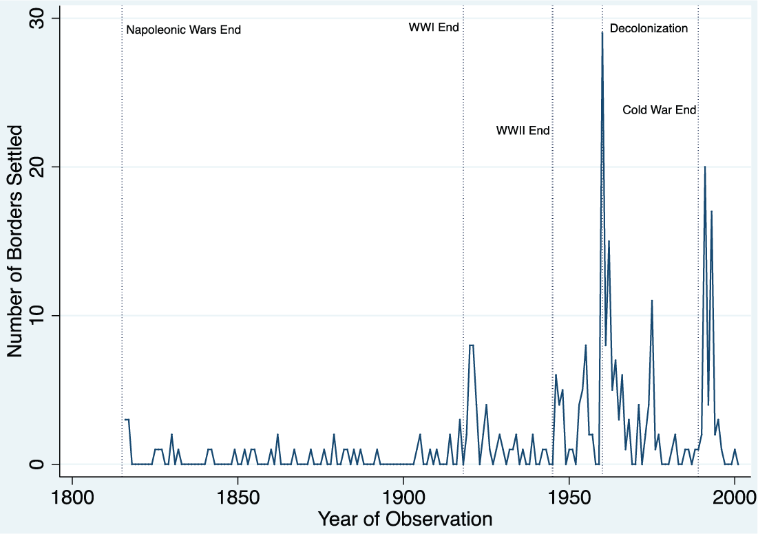
Full dyadic border settlements by year, 1816–2001.
Settlement trends, however, vary by region. Figure 2 plots the percentage of contiguous dyads with settled borders (as opposed to unsettled ones) over the period 1816–2001—first for the entire system (the first panel) and then for five individual regions (the remaining panels). Four general conclusions result from the data presented in this figure. First, border settlement has been steadily increasing over time. Some might argue that this trend derives from our coding decision not to permit contiguous dyads to unsettle their border. Although this could explain why we observe no downward trend, it does not necessarily imply an upward trend. That is, under our coding rules, settlement rates could be flat; indeed, in some regions and time periods, it seems to be (e.g. the Americas, 1946–1990). The fact that we see an upward trend, however, suggests that states see a need to settle their borders eventually and do so (i.e. positive duration dependence exists). Moreover, if territorial threat drives much interstate conflict (Vasquez, 2009), these settlement trends help explain why scholars find a decline in interstate violence (Pinker, 2011) and a rise in systemic peace (Goertz et al., 2016) over this period.

Percentage of contiguous dyads with settled borders (by region), 1816–2001.
Second, each region experiences a distinct settlement pattern, suggesting that de jure settlement processes unfold differently in each region. In the Americas, for example, a large percentage of settlements occur during the period 1920–1940. In contrast, Europe sees a settlement wave much earlier (about 1816–1850), while the Middle East/North Africa experiences a wave much later (about 1970–2000). These waves depend somewhat on when states enter the system. For example, a large number of states in Africa, the Middle East/North Africa, and Asia/Pacific gain independence later than European or Latin American states. Independence alone, however, does not explain these waves, as the significant lag between independence and settlement in the Middle East/North Africa and Asia/Pacific demonstrates. Third, post-colonial regions adopt former colonial boundaries more often than not (i.e. uti possidetis). This appears graphically as the sharp, almost vertical lines in Africa (in 1960), the Middle East/North Africa (1932–1936), and Asia/Pacific (1947–1948). The lines result from many states joining the international system (the denominator of the ratio) and immediately adopting colonial borders (the numerator of the ratio), which causes the ratio to rise steeply in a short period of time.
Finally, if we assume that territorial threat significantly increases the likelihood of conflict and de jure unsettled borders constitute one form of (latent) territorial threat, then Figure 2 also points toward more dangerous regions and time periods. In general, danger rises when a greater proportion of interstate borders remain unsettled. Two factors contribute to high unsettled border rates. The first occurs when new states gain independence from their colonizer, but either inherit borders never settled by colonial powers (e.g. Bhutan) or reject previous colonially drawn borders (Cambodia–Thailand). This explains many of the downward movements in the ratios graphed in Figure 2. The second factor simply involves border cases that elude settlement. Asia/Pacific, for example, sees a large number of these, especially around China and India. Indeed, based simply on the percentage of borders that remain de jure unsettled, the Asia/Pacific region appears to contain the most outstanding territorial threats.
Monadic data
In order to obtain a state-specific measure of territorial threat, we also converted the dyadic data described above into a monadic measure. 9 To create this measure, we use the Correlates of War Project’s Direct Contiguity Dataset (Stinnett et al., 2002) to identify a state’s land contiguous neighbors during each year of the period 1919–2001. We then use the dyadic data described above to construct a ratio of settled to total contiguous borders for each year that a state exists during this time period.
Figure 3 uses these monadic data to depict the mean ratio of states’ settled to total borders during the period 1919–2001. As above, higher ratios indicate more border settlement and, therefore, less territorial threat in the system, while lower ratios suggest the converse. According to Figure 3, states in 1919 had settled roughly half of their contiguous borders (a ratio of 0.51). This rose to above 80% around the end of the Second World War and above 90% in the 1990s—despite fluctuations that occurred as many new states entered the system in the 1950s, 1960s, and 1970s. Thus, as in Figures 1 and 2, we observe an increasing trend in border settlement over time. Although some borders remain unsettled—indicating that (latent) territorial threat persists—the vast majority of borders have been delimited via interstate agreement.
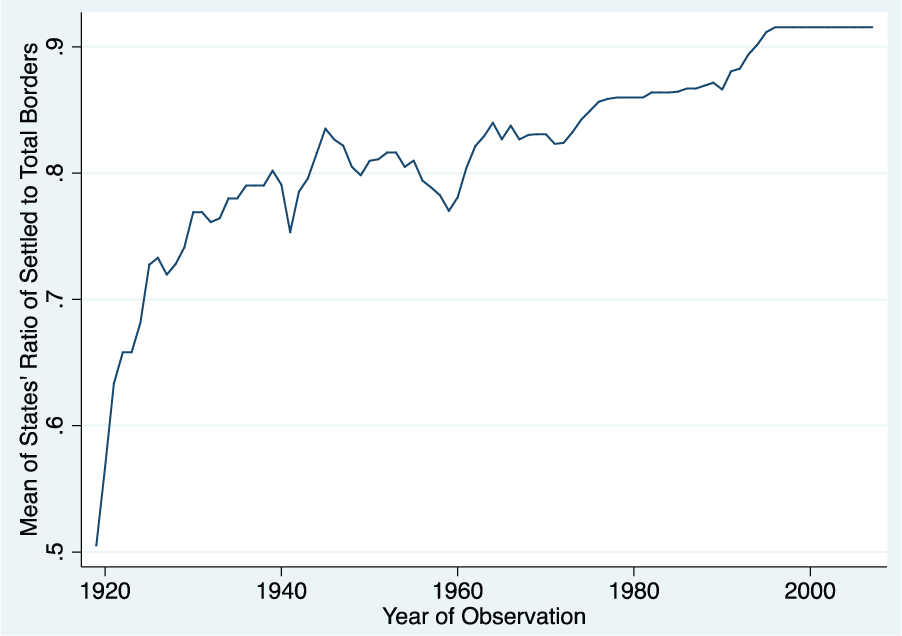
Mean level of states’ settled borders, 1816–2001.
Missing data
Our dataset currently lacks data on some contiguous dyads. This missing data fall into one of three broad groups. The first group contains dyads that were historically contiguous but eventually lost that contiguity—because other states enter the system (e.g. the Netherlands and France lose contiguity in 1830 when Belgium enters the system), existing states change shape (e.g. Ecuador and Brazil lose contiguity in 1916 after Ecuador cedes territory to Colombia), or one of the dyad members leaves the system (e.g. Austria–Hungary in 1918). The second group involves smaller historical states that eventually united into larger ones (e.g. Hanover and Mecklenburg Schwerin become part of a united Germany, while Tuscany and the Papal States join a united Italy). The final group concerns a series of contiguous dyads in Central Asia (e.g. Tajikistan–Uzbekistan) and Eastern Europe (e.g. Yugoslavia–Bulgaria) that previously fell within the Soviet Union. For these dyads, if we could not yet find evidence that the Soviets (or others with Soviet acquiescence) drew a boundary between the contiguous states (i.e. former republics), we opted for the safer approach of classifying the data as missing. 10
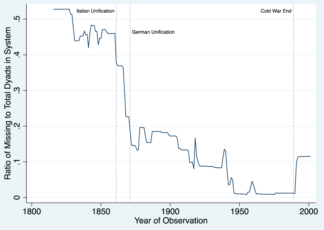
Figure 4 shows the missing data within our dataset over time. For each year, the figure charts the ratio of contiguous dyads for which we are missing data to the total number of contiguous dyads in the international system. As the figure demonstrates, we lack information on numerous contiguous dyads (n = 36) prior to 1861 (i.e. Italian Unification). This is a function of two factors: a small number of contiguous dyads that exist in the system and the presence of many individual German and Italian states on which we lack data. Once these latter states unite, the missing data drops substantially. 11 On a smaller scale, the opposite happens after the Cold War ends in 1990. At this time, the former Soviet Union spins off a series of contiguous dyads (i.e. former republics) for which settlement data proves difficult to find. This causes an increase in missing dyads within the data after 1990.
Missing (full dyadic) border settlement data, 1816–2001.
Overall, Figure 4 yields two conclusions. First, it demonstrates the prevalence and potential substantive effects of the various groups of missing dyads noted above. The extremely sharp decline after German and Italian unification, for example, indicates that these dyads constitute the largest missing data issue in our dataset. Second, we generally observe an exponential decay function in the figure. This suggests that missing data become a larger problem as one moves backward in time. One can infer from this that historical settlement data are more challenging to obtain, and that has indeed been our experience. Nonetheless, we continue working to fill in these data as our research uncovers new information.
Border settlement process data
One of the unique contributions of our dataset is its focus on the de jure border settlement process. In particular, we researched each contiguous dyad to create a narrative about the agents involved in, methods used in, and outcomes obtained during the border settlement process. 12 We address each of these components in turn.
First, numerous agents act during the de jure border settlement process. Most notably, dyad members themselves negotiate the delimitation of their own borders without any external assistance. This occurs in 41.42% of our (attempt-year) observations. In addition, two other groups of agents work toward border delimitation: colonial powers (38.65% of our observations) and third-party actors that assist dyad members in their efforts (17.80% of our observations). 13 The former includes states with colonial holdings that attempt to delimit the borders either within their holdings (e.g. the French delimitation of the Cambodia–Laos border) or between their holdings and that of an external actor (whether another colonial power or an independent state; e.g. the Congress of Berlin or the Chinese–French settlement of the Chinese–Laos border). In contrast, third parties either work alongside dyad members to settle their borders (e.g. mediation) or determine those borders’ delimitations on dyad members’ behalf (e.g. post-war conference, arbitration, or adjudication).
We find 575 instances of colonial state involvement in de jure border settlement processes, 229 of which (39.83%) involve more than one colonial state. 14 Most colonial states play a role as agents in the border settlement process at some point in time (see Online Appendix, Part C). Two colonial powers dominate, however: the UK (involved in 50.78% of all colonial efforts) and France (50.96% of all colonial efforts). This results from the large colonial holdings of these states throughout Africa, the Middle East, and Asia. Indeed, the remaining colonial states possess smaller colonial portfolios and, as expected, appear significantly less frequently in border settlement processes. Portugal and Germany, for example, are involved in 11.65 and 10.78% of all colonial efforts, respectively, while Spain, the Netherlands, and Italy are involved in 5.57, 2.43, and 4.87% of all colonial efforts, respectively. 15
We also uncover 281 instances of third-party involvement, 162 of which (57.65% of all third-party efforts) involve more than one third-party actor (see Online Appendix, Part C). 16 When considering these agents, three general conclusions emerge. First, a significant number of states (n = 38) and organizations (n = 5) function as third parties in border settlement processes. Moreover, these actors reside within every region of the world—although third-party states are more frequently found in the Americas or Europe (78.95% of all third-party states). Second, major powers function as third parties more often than minor powers. These major powers (along with the percentage of all third-party efforts in which they are involved) include Austria–Hungary (9.96%), France (38.79%), Germany (13.52%), Italy (26.33%), Japan (23.49%), Russia (21.00%), the UK (53.74%), and the United States (33.81%). The remaining actors are at most involved in approximately 5% of third-party efforts each, with many at or below 1% each. Finally, the United Nations and the International Court of Justice feature most prominently among organizations in border settlement processes; they are involved in 7.12 and 4.27% of all third-party border settlement efforts, respectively. Cumulatively, such findings demonstrate that our data contain a variety of agents that work toward border settlement throughout the world.
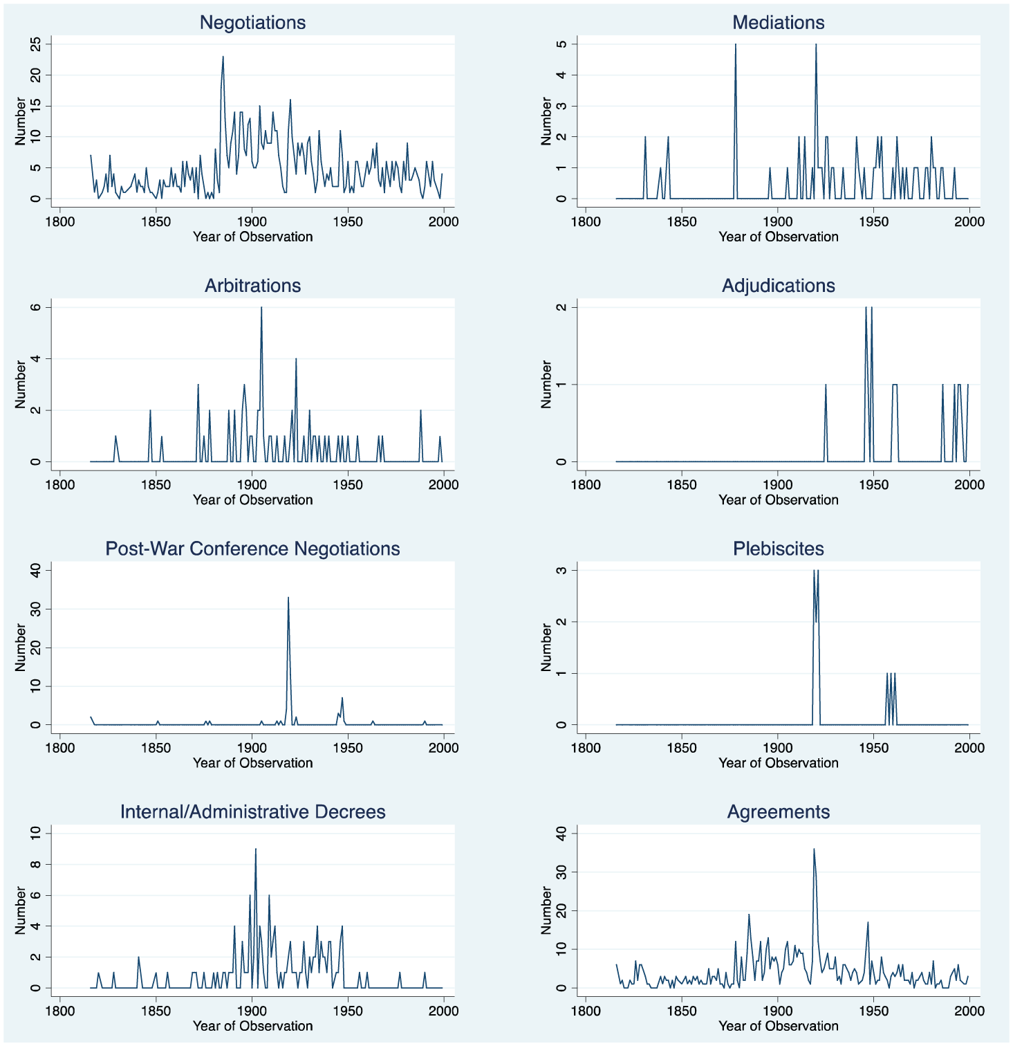
Second, agents work towards de jure border settlement via numerous distinct methods. These methods (i.e. conflict management strategies) range from bilateral negotiations to various third-party conflict management tools, including mediation, arbitration, adjudication, post-war conferences, plebiscites, and internal/administrative decrees (for full definitions of these methods, see Online Appendix Part A.2). Overall, we collected information on 1410 unique conflict management attempts. Of these, 877 are (bilateral or multilateral) negotiations (62.20%), 62 are mediations (4.40%), 62 are arbitrations (4.40%), 14 are adjudications (0.99%), 86 involve post-war conferences (6.10%), 11 are plebiscites (0.78%), 131 are internal/administrative decrees (9.29%), and 167 involve the use of force (11.84%). The panels in Figure 5 depict agents’ use of each of these strategies over time. Because these frequencies vary substantially by strategy, we allow the y-axis to vary across the panels. This helps to visually discern trends over time. 17
The method and outcomes of border settlement processes, 1816–2001.
The first panel of Figure 5 charts the frequency with which states use negotiations during their border settlement processes over time. As this panel demonstrates, actors negotiate constantly over border delimitation during the period 1816–2001; years in which no negotiations occur over an interstate border somewhere in the system are rare. Yet the data reveal waves of negotiation as well. In 1884–1885, for example, the Congress of Berlin generates negotiations over a series of interstate (primarily colonial) borders. Similarly, in 1919–1920, a number of negotiations determine the status of borders throughout Europe. These two waves are unusual—as are the events that produced them. Nonetheless, negotiations exist outside of such rare events as well, and we see substantial variation throughout the entire time period under observation. As an illustration, negotiations occur (on average) more frequently around the turn of the twentieth century (1875–1925) than in earlier (1816–1875) or later (1950–2001) periods.
In contrast to negotiations, the remaining strategies are used significantly less frequently. First, mediations also appear throughout the entire time period, but peak at five in 1878 and 1920 (second panel, Figure 5). Both peak years correspond with (anomalous) post-war activity. In the former, the Great Powers mediated the Treaty of San Stefano (1878), which produced Bulgarian, Romanian, and Serbian borders. In the latter, European states created borders for Poland and other Eastern European states after the First World War (1920). Second, arbitration occurs just as frequently as mediation, but demonstrates a rather different empirical pattern (third panel, Figure 5). The greatest number of arbitrations occurs in 1905—covering two Latin American, three African (involving Namibia and Zambia) and one Middle Eastern border. Third, agents employ adjudication less than any other method (fourth panel, Figure 5). Given the salience of territorial disputes, this is not surprising (e.g. see Hensel et al., 2008); states may want to retain control over decisions that affect their sovereign jurisdictions. The adjudication data support this position, although adjudications admittedly rise after the creation of the United Nations and its standing court. Fourth, post-war conferences concentrate after the World Wars, as one might expect. The two large waves of post-war conferences (fifth panel, Figure 5) correspond to the periods 1919–1920 and 1947. Finally, plebiscites are the rarest strategy of all. They appear in two spatially and temporally bounded periods: Europe after the First World War (1919–1920; land involving Polish, German, and Austrian states) and Africa around the beginning of decolonization (1957–1967; Ghana–Togo and Cameroon–Nigeria).
The seventh panel of Figure 5 depicts colonial states’ use of internal/administrative decrees that delimit boundaries within their colonial possessions. These decrees concentrate during the times when colonial states actively work with one another to define their respective colonial empires (1890–1950), suggesting that external and internal delimitations occur in tandem. Although all colonial states use this strategy, the peaks that appear in the figure are driven by France’s behavior in Africa. From 1899–1909, France worked to delimit borders involving Algeria, Benin, Burkina Faso, the Central African Republic, Chad, Guinea, Ivory Coast, Mali, Mauritania, Niger, Senegal, and Tunisia. Nonetheless, the use of this strategy exists throughout the colonial period and disappears when decolonization begins in the 1950s.
Although Figure 5 demonstrates variation in each strategy’s usage over time, it does not indicate how often different types of actors use each strategy. Table 1 pursues this latter question, focusing particularly on the behavior of colonial states and third-parties. As the table demonstrates, colonial states rely primarily on two conflict management strategies: negotiation (69.91% of their involvement in border settlement processes) and internal/administrative decrees (20.17%; first column, Table 1). This makes intuitive sense, for the colonial powers are major states that are attempting to delimit borders within their colonial possessions (internal/administrative decrees) or between their colonial holdings and either an external state or the holdings of another colonial power (requiring negotiation between colonial powers). The remaining strategies (including mediation, arbitration, adjudication, and post-war conferences) appear far less frequently. In contrast, third-party behavior seems more balanced across the various strategies (second column, Table 1). Roughly 20% of third-party efforts employ negotiation (20.28%), mediation (19.93%), arbitration (17.44%), and post-war conferences (21.00%). Third parties rarely use the remaining strategies.
Use of conflict management strategies by colonial and third-party actors
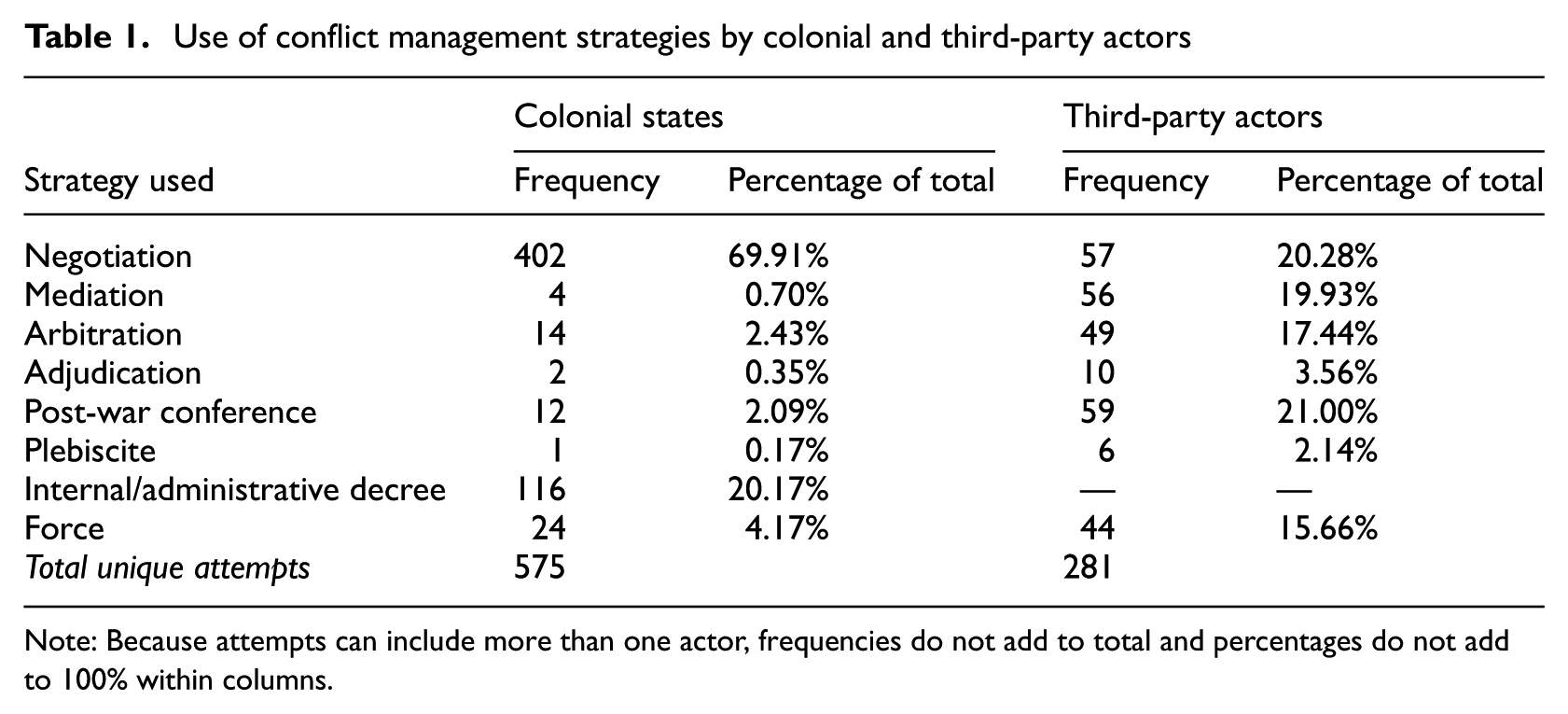
Note: Because attempts can include more than one actor, frequencies do not add to total and percentages do not add to 100% within columns.
The third component of the border settlement process concerns the outcomes of conflict management efforts. We presented data on full de jure border settlement earlier. In the process data discussed here, we consider whether any agreement appears during each individual conflict management attempt. These data therefore capture low-level cooperative agreements, such as treaties of friendship, modus vivendi, agreements to arbitrate, or third-party settlements (see above for details and examples). We identify 770 agreements, and the last panel of Figure 5 presents the frequency of these agreements over time. Two conclusions emerge from the figure. First, waves of agreements occur around the Congress of Berlin (1885), the end of the First World War (1919–1921), and the end of the Second World War (1946–1947). These rare events produce much border activity, as noted elsewhere in the data. Yet activity is not confined to these anomalous periods, leading to a second conclusion: agreements—like each individual conflict management strategy—occur throughout the entire 1816–2001 period. Thus, it appears that actors work regularly to address unsettled borders (and make progress doing so), even in the absence of more anomalous system shocks.
In the end, we supply the border settlement process data—on agents involved in, strategies used in, and outcomes of de jure border settlement—in two formats: the attempt-year and the dyad-year. The attempt-year data create one observation for each year of a unique conflict management attempt. Two points are worth noting about this data structure. First, if a dyad uses two unique tools in the same year, the dataset contains two separate observations for that year—one for each attempt. India and Pakistan, for example, fight a war in 1965 (force), and the British Prime Minister mediates an end to it (mediation). We therefore create one observation for force in 1965 and another for mediation in 1965. Second, if an attempt continues for multiple years, we code additional observations for these “ongoing” years. The United States and the UK (concerning the United States–Canada border), for example, use force against one another from 1812 to 1814, until the Treaty of Ghent ends the hostilities in 1814. This creates three observations in the attempt-year dataset—one each for 1812, 1813, and 1814. These ongoing attempt-years add another 1246 observations to our attempt-year dataset. 18
The dyad-year dataset takes the attempt-year data and collapses it into one unique observation for each dyad-year. In essence, this amounts to removing the separate observations created for different strategies used in the same year. In the above example, the India–Pakistan dyad would have one observation for 1965, receiving credit for both mediation and force within that single observation. Although the attempt-year data contain more information on third-parties, colonial states, and agreement details, we expect the dyad-year dataset to align better with the units of analysis commonly used in international relations research.
A comparison with territorial claims and territorial changes data
De jure border settlement relates conceptually to territorial claims and territorial changes. Neighboring states often hold conflicting claims to sovereignty over the same border territory when borders remain unsettled. As these neighbors subsequently sign international agreements that delimit the entirety of their mutual borders (i.e. settle their borders), they should also renounce and transfer territory to resolve any conflicting claims. One might therefore ask whether territorial claims and border settlement are simply two sides of the same coin and whether territorial changes are merely a reflection of the border settlement process.
To address such questions, we compare our data to the Issue Correlates of War (ICOW) Project’s data on territorial claims (version 1.01), which tracks all territorial claims in the world during the period 1816–2001 (Frederick et al., 2016), and the Correlates of War (COW) Project’s data on territorial changes (Tir et al., 1998). A territorial claim exists if the official representatives of a state “make explicit statements claiming sovereignty over a specific piece of territory that is claimed or administered by another state” (Hensel et al., 2008: 128). De jure border settlement, in contrast, concerns agreement upon and acceptance of border delimitations under international law. Territorial claims therefore relate conceptually to border settlement; it would be logical to observe claims more frequently when borders lack delimitation. Yet they are also conceptually distinct. Official statements may theoretically not exist when borders are de jure unsettled (e.g. Kenya–Sudan or India–Bhutan) or emerge after de jure settlement occurs (e.g. Ecuador–Peru or China–Vietnam).
A comparison of the IBAD to the ICOW data confirms this point. The details of this comparison appear in the Online Appendix (see Part D.1), and we derive two noteworthy conclusions from it. First, border settlement and territorial claims are, in fact, conceptually related but distinct. 19 Although border settlement and territorial claims data often align, they also diverge in important ways. A significant number of contiguous dyad-years, for example, lack claims before border settlement (23.83% of dyad-years) or contain claims after border settlement (17.73% of dyad-years). Thus, the two concepts cannot be capturing identical information.
Second, (un)settled borders create a distinct context in which territorial claim characteristics vary along several dimensions. Claims begin less frequently, are shorter, possess less salience, concern islands more frequently, and involve less violence (both militarized interstate disputes 20 and wars) after de jure border settlement occurs. Furthermore, claim frequency varies by region across the pre- and post-settlement contexts. Territorial claims are less likely to occur after de jure border settlement in the Americas, Middle East/North Africa, and Asia/Pacific; more likely to arise after de jure border settlement in Africa; and no more or less likely to appear after border settlement in Europe. These latter trends most likely result from how border settlement occurs in each region. African dyads, for example, typically (were encouraged to) adopt borders delimited by colonial powers upon independence (i.e. uti possidetis), which subsequently impedes their ability to raise territorial claims pre-de jure settlement (i.e. acceptance of colonial borders constitutes de jure settlement; see above). In contrast, Latin American dyads often enter the international system with territorial claims, as Spain failed to delimit the borders between its viceroyalties clearly in the Americas. These claims necessarily arise before de jure settlement, then, as no acceptable colonial delimitations existed prior. Based on such findings, we conclude that de jure settlement differs by region. Future research might therefore investigate the reasons for and consequences of this variation in greater detail.
Our second analysis compares de jure border settlement to territorial changes, revealing very similar findings to those outlined above. The details of this analysis appear in the Online Appendix (see Part D.2) and yield two overarching conclusions. First, de jure border settlement is not synonymous with territorial change. Although territorial changes certainly occur more frequently before borders settle, many dyads settle their borders without territorial changes, and dyads execute a significant number of territorial changes after de jure settlement. Thus, territorial changes may play a part in the de jure settlement process, but they are not necessary for it to occur. This highlights the importance of thinking about de jure settlement independent of territorial changes.
Second, the characteristics associated with territorial changes differ between the pre- and post-border settlement periods. After de jure settlement, territorial changes are less likely to involve conquest 21 or violence (between involved states), and concern smaller geographic areas (about 50% less area) than pre-settlement changes. Such findings echo earlier work that demonstrates a decline in interstate violence after de jure settlement (e.g. see Kocs, 1995; Owsiak, 2012) and suggest that conquest becomes a less acceptable method of executing territorial transfers after border settlement occurs—a point consistent with the territorial integrity norm (Zacher, 2001) and our stance on border treaties under international law (see above and Appendix A.3). Finally, the frequency of territorial changes across the pre- and post-settlement contexts varies by region. In particular, territorial changes are less likely to occur after border settlement in the Americas, Middle East/North Africa, and Asia/Pacific; more likely to occur after border settlement in Africa; and no more or less likely to occur after border settlement in Europe. We suspect that these characteristics result from the same regional differences in the de jure border settlement process that we discussed above.
In the end, although de jure border settlement is conceptually related to both territorial claims and territorial changes, it differs substantially from each—suggesting the concepts are not identical. Our comparisons reveal that border settlement creates a unique context: territorial claim and territorial change characteristics differ markedly when one compares the pre- and post-settlement periods. Future research might therefore use the (de jure settled) status of borders to study territorial claims and changes in greater detail—perhaps offering novel insight into a research agenda that began over 20 years ago (e.g. see Huth, 1996; Huth and Allee, 2002).
Future expansion
Future expansions of the dataset will address four issues. First, we plan to broaden the temporal domain of the dataset beyond 2001. Second, we aim to complete missing data as our continued research uncovers it. Third, we will search for a way to incorporate maritime borders into the dataset. The de jure settlement of these borders is a distinctly post-Second World War phenomenon; nonetheless, integrating maritime border settlement data into the IBAD may offer opportunities to explore research questions on the relationship between territorial claim types (e.g. whether dyads settle land borders before turning to maritime ones, or whether these two claim types are linked together), as well as differences in settlement processes across claim types. Ásgeirsdóttir and Steinwand (2015) capture much of what is needed to create a dataset for maritime borders that is analogous to the IBAD. As more of their data become publicly available, we will consider further whether it might be used alongside the IBAD to offer coverage that our dataset currently lacks. Finally, we will explore the possibility of using a Geographic Information System to examine better the geographic characteristics of border agreement content. 22 With such information, scholars might gather data on the distributional outcomes of border negotiations over time, thereby gaining a deeper understanding of the relationship between geographic characteristics on the one hand and negotiation outcomes or conflict on the other. This could, for example, offer insight into why and how borders change significantly over time, why some borders settle in segments (e.g. Afghanistan–Iran), and why segment settlements sequence as they do (for a larger discussion on sequencing in conflict management, see Diehl and Regan, 2015).
Despite these forthcoming efforts, the International Border Agreement Dataset currently offers numerous contributions. First, it supplies a wealth of detailed information on the (settled) status of borders under international law (de jure settlement), as well as the agents, methods, and outcomes that produced this status. It is therefore relevant not only to research on territorial conflict, but also to work on international law, cooperation, and conflict management. Second, our data capture a significant dimension of what scholars mean by “territorial threat” and “settled borders” more directly than previous research (see Online Appendix Part A.1). We therefore suspect these data will be useful to those working on research programs related to the territorial peace, the democratic peace, rivalry, and the steps to war. Third, our data differ in important ways from existing data on territorial claims and territorial changes, potentially offering greater insight into the contexts in which such claims and changes occur. Finally, as policy-makers seek to understand some of the most pressing contemporary conflicts, our data offer insight into how states successfully resolve one of the most contentious issues they face.
Footnotes
Acknowledgements
We thank Paul Diehl, Chad Clay, Toby Rider, three anonymous reviewers, and the editor for their helpful feedback, as well as Patrick Howell, Cody Knapp, and John Willingham for their research assistance. All data, replication materials, and instructions regarding analytical materials upon which published claims rely are available online through the SAGE CMPS website.
Funding
This research received no specific grant from any funding agency in the public, commercial, or not-for-profit sectors.
Notes
References
Supplementary Material
Please find the following supplemental material available below.
For Open Access articles published under a Creative Commons License, all supplemental material carries the same license as the article it is associated with.
For non-Open Access articles published, all supplemental material carries a non-exclusive license, and permission requests for re-use of supplemental material or any part of supplemental material shall be sent directly to the copyright owner as specified in the copyright notice associated with the article.