




Abstract
This paper examines whether non-monotonic patterns exist between forest coverage and conflict processes in Myanmar. Specifically, the paper finds that forest coverage and civil conflict follow an inverted U-shaped relationship: conflict decreases at extremely low and high densities of forest coverage but increases at medium and somewhat high forest densities. Following the logic of the variability of rugged terrain, we argue that this pattern reflects the dual mechanisms of refuge and tactical advantages for rebel groups, who intentionally use such terrain to maximize logistical advantage while minimizing the military advantages enjoyed by better equipped government forces.
During my travels in Kachin State, I happened upon a map showing two types of armed bases in the Hukawng Valley: the rebels' and the government's. The rebels’ bases follow a roadless chain perpendicular to the Ledo Road, the Hukawng Valley's only thoroughfare for motor traffic. Some of the bases on this chain could possibly be linked by riverboat, but many of them would have to be linked by porters walking on foot – or by convoys of elephants. By contrast, the Tatmadaw's [government military] bases were all on the Ledo Road, linked by jeep or by truck.
(Jacob Shell, Giants of the Monsoon Forest: Living and Working with Elephants)
Introduction
A large body of scholarly research has consistently found a strong relationship between topography and civil conflicts. These studies demonstrate that variations in terrain can significantly impact both the onset and duration of civil conflicts (Collier et al., 2004; de Rouen and Sobek, 2004; Fearon, 2004). A general consensus has emerged that militarized insurgencies are associated with rugged mountain areas and forests (Tollefsen and Buhaug, 2015). Rugged mountainous areas tend to have more ethnic diversity and stratification, making ethnic conflicts more likely to occur (Fearon and Laitin, 2003). Meanwhile, forests also have several features that can impact civil conflicts (Le Billon, 2001; Ross, 2004: 346). However, existing quantitative studies have failed to show a consistent relationship between forests and civil conflicts on a global scale (Rustad et al., 2008). 1
One problem with conducting large, cross-national studies on a global scale is that they lack contextualized explanatory frameworks within actual conflicts because “they are not developed to explain variation in landscapes of warfare, but rather to identify similarities” (Korf, 2011: 739). As a result, empirical inconsistencies are quite common. For example, Buhaug and Rød's (2006) study of civil conflicts in Africa finds no evidence that forest coverage or mountainous terrain contributes to civil conflicts, while Rustad et al. (2008) find mixed support for the impact of forest coverage on civil conflict onset and duration.
These studies have implicitly assumed a monotonically 2 positive relationship between rugged terrain and conflict. However, recent studies have shown that mountainous terrain's impact on insurgencies follows a non-monotonic pattern because insurgents look for optimal terrain advantage instead of fighting in the most extreme locations (Carter et al., 2019; Linke et al., 2017). Ruggedness of the terrain, defined by significant-average changes in elevation within a defined space (Sutton and Battaglia, 2019), would increase operational costs for the state but decrease such costs for insurgents (Shaver et al., 2019). Although these studies have found a non-monotonic pattern between mountainous terrain variability and civil conflict, there are few studies to date that have investigated whether a similar logic exists between forest and civil conflicts.
It is with this purpose that we investigate how forest coverage relates to conflict processes on the ongoing civil war in the Southeast Asian country of Myanmar, formerly known as Burma. Myanmar often serves as a prime example of how forest coverage and the timber trade are associated with protracted insurgencies (Rustad et al., 2008). Insurgent groups have used timber resources for revenue, while government forces are suspected of seizing control over these resources for trading benefits with neighboring states. While existing studies have looked at how internal conflict dynamics, such as ceasefire and political economy, affect patterns of deforestation in Myanmar (Woods et al., 2021), there is a growing body of research on how changes in conflict dynamics in post-conflict societies, such as Colombia, have impacted forest coverage and land use patterns (Murillo-Sandoval et al., 2021; Prem et al., 2020). However, few studies have explored how forest coverage affects the dynamics of civil conflict processes in the context of Myanmar.
Myanmar provides an ideal case study for examining the relationship between forest coverage and civil conflicts owing to its diverse range of forest cover and civil conflicts between the government and various armed groups. While we are using Myanmar as a case study to explore this relationship, we are not attempting to provide a comprehensive explanation for the causes of Myanmar's prolonged civil war. The insurgencies in the country have been shaped by a variety of factors over time, including communist rebels during the Cold War and ethno-nationalist ones in the post-Cold War period. In recent years, conflict has intensified between the government and various ethnic groups along Myanmar's borderlands with Bangladesh, China and Thailand since the most recent coup.
Many of Myanmar's armed rebels reside in mountainous forest areas that are difficult to access, where they continue to engage in guerrilla-style fighting against government forces and each other (Callahan, 2007; Smith, 2007). As the opening quote suggests, ethnic rebel bases in Myanmar's Kachin State are deliberately located in forests to make them more difficult to access from the outside (Shell, 2019). Despite many in-depth studies on the timber trade and ethnic conflict dynamics in the country, ongoing conflicts in Myanmar remain one of the least studied cases in the conflict studies literature, particularly from a quantitative approach (with the notable exception of Christensen et al., 2019).
Using newly available data from the Armed Conflict Location & Event Data Project (ACLED) 3 at the Myanmar township level and the Global Forest Change (GFC) dataset provided by the University of Maryland, 4 we constructed a dataset of Myanmar's conflict processes from 2010 to 2018. Our study builds upon previous research that have explored the non-monotonic patterns between rugged mountainous terrain and civil conflicts (Carter et al., 2019; Linke et al., 2017), and examines whether similar patterns exist between forest coverage, 5 which we define as territory with forested terrain that limits accessibility, and conflict processes in Myanmar. Our findings reveal an inverted U-shaped relationship between forest coverage and conflict: conflict decreases at extremely low and high levels of forest coverage but increases at medium and somewhat high levels of forest coverage. We argue that this pattern reflects the dual mechanisms of refuge and tactical advantages for rebel groups, who intentionally use such terrain to maximize logistical advantage while minimizing the military advantages enjoyed by better equipped government forces. We also separate the effects of these two mechanisms using spatial data and show that the shelter mechanism has a larger impact on insurgencies. Thus, our paper makes two novel contributions: uncovering the non-monotonic relationship between forest coverage and civil conflict and identifying the causal mechanisms that drive the relationship between the two.
The paper is organized as follows. First, we review the literature on terrain, forest coverage and civil conflict dynamics. Second, we provide an overview of the ongoing civil war in Myanmar, including a brief history and recent developments in the civil conflict. Third, we contextualize the Myanmar case within the broader literature on forest coverage and conflict processes and present our argument for how forest coverage contributes to civil conflict in this context. Fourth, we present our empirical analysis on how forest coverage in Myanmar affects the frequency of militarized conflicts in the country. Finally, we conclude with reflections on the dynamics between forest coverage and insurgency in the Myanmar, as well as implications for further studies on the topography of civil wars.
Rugged terrain, forest coverage and insurgency
Terrain has a significant impact on the onset and duration of militarized insurgencies (Collier and Hoeffler, 2004; Fearon and Laitin, 2003). Many historical cases of insurgencies, such as the ones waged by the Chinese Communist Party during the Chinese Civil War, the Viet Cong during the Vietnam War, and the FARC rebels in Colombia, show how insurgent groups have exploited the inaccessibility of terrain to either defeat forces that were superior to them or manage to sustain protracted insurgencies (Boorman and Boorman, 1966; Kocher et al., 2011; Reardon, 2018). Although empirical studies have shown the link between the two, the results are nonetheless inconclusive (Carter and Veale, 2013; Carter et al., 2019; Lacina, 2006). Moreover, many of the measurements of rugged terrain are very crude and often use the country as the unit of analysis (Shaver et al., 2019). Such measurements are problematic because “country-level aggregates often suffer from a mismatch between data and the hypothesized casual mechanism, which may result in ecological fallacy” (Tollefsen and Buhaug, 2015: 12–13).
Meanwhile, recent progress on the geography of civil conflicts has emphasized the optimal nature of rugged mountainous terrain (Linke et al., 2017; Shaver et al., 2019). Linke et al., for example, emphasized the crucial role of operational costs of context, which they argue should vary substantially by variation in mountainous terrain. Thus, the focus should be on the interactive dynamics among warring parties across terrains and sociodemographic contexts (Linke et al., 2017: 524). Carter et al. pushed this argument on the optimal nature of terrain even further. Their study demonstrates that more rugged terrain is not always more auspicious for rebels, because the “most highly and uniformly rugged areas are usually not suitable long-term bases” (Carter et al., 2019: 1448). Therefore, areas with significant variation in terrain ruggedness are particularly advantageous for the rebels, because they “offer both refuge from state attack as well as less rugged areas more amenable for long-term settlement” (Carter et al., 2019: 1449).
Other than rugged terrain, forest coverage is another factor that can affect civil conflict through two related processes. First, forests offer rebels a space to hide from government forces, allowing them to rest, recruit and replenish supplies. This makes it more difficult for government forces to detect and monitor rebel activity (Hendrix, 2011: 347). Insurgents often use forests as operational bases owing to their ability to provide shelter and hide from government forces. In the Vietnam War, for example, the Americans used herbicide bombs to destroy forest cover in an effort to prevent the Viet Cong rebels from using them as a safe haven (Stellman et al., 2003).
Additionally, rebels can use forests to reduce both numerical and technological advantages against conventionally superior militaries. During the Vietnam War, for example, forests narrowed these disparities as “large unit operations simply will not work against small units of guerrillas in jungle environments” (Pelli, 1999). Battles fought in heavy forests typically involve special reconnaissance infantry (e.g. marines or rangers). Fielding numerically larger armies will subject the conventionally superior side to frequent ambushes and logistics problems. Heavily forested areas thus prevent heavy military equipment from being easily employed with forest canopies further hindering aerial detection (Tollefsen and Buhaug, 2015: 11). Conventionally superior militaries are forced to use smaller units to regularly patrol and identify rebel logistics centers (i.e. safe havens). Thus, even with inferior weapon systems and smaller armies, insurgents can effectively wage a sustained war with the help of heavy forests.
We contend that the same logic of optimal rugged terrain should also apply to the relationship between forest coverage and civil conflicts. We argue that rebel groups use operational cost advantages by fighting in areas with optimal forest coverage rather than the areas with the most forest coverage. These locations offer the best tactical advantage against more professional and better equipped government forces, and also provide a safe haven for rebels to rest and resupply while still being hospitable enough for long-term settlement. This leads us to our main hypothesis:
Main hypothesis
For a given location, forest coverage and battle frequency between state forces and insurgents exhibit a non-monotonic inverted U-shape relationship: battles increase with forest coverage until a threshold point and then diminish as forest coverage increases.
Civil conflicts in Myanmar
As the largest country in mainland Southeast Asia that has rugged mountain ranges and extensive forests surrounding the lowland central plains, Myanmar's geography makes its peripheral regions difficult to reach and govern (Scott, 2009; van Schendel, 2002). Because of the difficulty of accessing and conquering these mountainous peripheral regions that formed the border with its neighboring states (Han, 2020), its borderland area has been host to prolonged insurgencies since its independence from Britain in 1948. Indeed, one might argue there is ethnogenesis owing to terrain differences in the country as the rugged terrain of Myanmar's peripheral regions differs substantially from the relatively flat areas where the majority Bamar live (Carter et al., 2019; Scott, 2009). The deep colonial legacies of ethnic fractures proved difficult to overcome, and communal violence broke out soon after with ethnic groups carrying out open insurgency against the central government (South, 2008). A communist insurgency also accompanied these ethnic rebellions, and within a year of independence, Myanmar found itself in a bitter civil war that engulfed much of its territory (Lintner, 1999: 12).
Myanmar's civil war was heavily affected by geopolitical conflicts in the region during the Cold War. The Chinese nationalist Kuomintang (KMT) troops, defeated in the Chinese civil war, invaded and occupied parts of Myanmar's Eastern Shan States from 1950 onwards for a decade, which significantly disrupted the ongoing military balance within the country (Callahan, 2005; Taylor, 1973). Furthermore, the KMT war economy of opium smuggling played a leading role in making the Golden Triangle area one of the main sources of drug trafficking in the world for decades (Chin, 2009). In this way, Myanmar's civil war has a long history of association with drug financing (McCoy, 1991). During the Cold War, the Chinese communist government provided support for the communist troops in Myanmar as well (Lintner, 1990). Likewise, since the mid-1950s, Myanmar's other neighbor Thailand has practiced a “buffer zone” policy toward various ethnic rebels along the bilateral border (Lintner, 1995: 72). Although the Thai state did not offer open support, rebel armies “were allowed to set up camps along the frontier, their families were permitted to stay in Thailand and they could buy arms and ammunition” (Lintner, 1995: 74). Thus, international support from its neighbors significantly aided insurgent activities within the country (Han, 2019).
The end of the Cold War witnessed the termination of the communist insurgency, and the Myanmar government managed to sign a series of ceasefire agreements throughout the early 1990s with a variety of ethnic rebel groups (Callahan, 2007). These ceasefire agreements temporarily halted open hostilities in the battlefield in exchange for economic cooperation and resource exploitation (Woods, 2011), but they nonetheless allowed these ethnic rebel groups to remain autonomous and maintain their military capacities. Such a delicate balance of power between the rebel groups and the central government broke down in 2009, and intensified conflicts have since erupted in the borderland area between China and Myanmar. The Myanmar military has reneged on earlier ceasefire agreements and attempted to eliminate these rebel groups once and for all (Sadan, 2016). Although there have been attempts at peace dialogues, these conflicts continue unabated and have intensified since the 2021 military coup.
At the same time, the Myanmar military enjoys significant asymmetrical power over insurgent groups. For example, the Myanmar military fielded 350,000 active-duty soldiers compared with powerful ethnic armed groups like the Kachin Independence Army with around 16,000 active-duty soldiers. 6 It employs a four-cuts strategy that utilizes light infantry to search for and locate rebel bases and launch brutal attacks against civilian villages to draw out insurgents. These tactics attempt to generate larger tactical battles that reduce the forest advantages given to rebels. 7 As for technological disparities, the Myanmar military has extensive armored and aerial equipment, possessing 150 tanks and 280 towed artilleries with 120 combat aircraft (Cordesman and Kleiber, 2006). There is little evidence that insurgents possess heavy equipment, and they have much less enough ammunition for their soldiers. Given the stark disparity in military power between the Myanmar military and insurgents, the existence of mountainous terrain and heavy forests potentially helps explain the persistence of many insurgencies.
Forest coverage and conflict in Myanmar
Myanmar is a prime example of how forest coverage influences insurgency dynamics, and one of the main characteristics of Myanmar's long civil war is the prominent role played by its rich forest resources (Global Witness, 2003). The country remains one of the most forested countries in Southeast Asia, with forests covering 43% of the country according to United Nations Food and Agriculture Organization's estimate in 2015 (Cho et al., 2017: 28), even though there has been reported rapid loss of forest coverage in the past decades (Bhagwat et al., 2017; Treue et al., 2016). In addition to extensive forests, Myanmar also features very mountainous terrain, ranking among the top 20% of countries in both average and variable elevation. 8 Indeed, during Myanmar's modern history of civil insurgency, when rebel groups retreated from government forces they often ended up in forested mountain regions, such as Pegu Yoma and the borderland areas with China, India and Thailand (Lintner, 1999). Furthermore, as Myanmar's ethnic states are located in surrounding peripheral areas bordering neighboring states, civil conflicts in the country do tend to cluster in these heavily forested and more mountainous regions.
To illustrate the complex relationship between forest coverage, mountainous terrain and conflict, consider Figure 1, which displays the geographic battle locations between government and insurgent forces, overlaid by forest coverage (a) and mountainous terrain (b). The figure shows that areas with heavy forest coverage and mountainous terrain occur in the peripheral regions of the country where most of the country's ethnic minority groups reside, confirming the complex relationship between terrain, difficulty of access and lack of state consolidation in peripheral regions (Hendrix, 2011). For this reason, micro-analyses seeking to link these factors together are needed.

Battle locations, forest coverage, and mountainous terrain (2010–2018). (a) Forest Coverage. (b) Mountainous Terrain. Notes: Figure was generated using Hansen's GFC Data 1.8, SRTM 4.0, and ACLED.
Data
We test our main hypothesis by examining the relationship between forest coverage and battle incidence, which is an aggregated count of battles in grid i and in year t. This measure comes from the ACLED dataset that is geocoded by the centroid location at the grid level. Each conflict is defined as an event that “occur[s] between designated actors – e.g., a named rebel group, a militia or a government”. Since our argument focuses on insurgent activity, we narrow our conflict data to only include violent battles 9 and explosions or remote violence. This definition excludes riots and demonstrations, which are also reported by the ACLED dataset. 10
As with all media-reported event data, coders for ACLED rely on secondary and local sources to determine the identity of combatant groups. For Myanmar specifically, ACLED relies on local media such as Kachinland News and the Shan Herald Agency in the local language and partners with Myanmar Peace Monitor to ensure data reliability. While ACLED does not identify initiators of the data, it has the identity of the main participants such as insurgent or government actors. We remove any battle between insurgents and keep only battles between government and insurgent forces 11 as the scope of our argument does not explain the patterns of conflict between rebel groups. 12 Because the occurrences of conflict events are measured at a daily level while deforestation data are measured annually, we aggregate the data to the grid-year level and use an annual count of battle incidences to ensure data comparability. Altogether, this ACLED battle incidence sample contains approximately 183 sets of grids in Myanmar from 2010 to 2018. 13
Data accuracy for georeferenced locations is critical to ensure consistent and unbiased estimates for our analysis, 14 and we employ several methods to ensure locational accuracy, such as the use of different areal scaling to generate consistent estimators (see Appendix A2 for a more thorough discussion of areal scales). For our analysis, we selected 75 × 75 km grids as our optimal grid size. 15 For robustness, we also include the georeferenced event dataset from the Uppsala Conflict Data Program (UCDP), which has a much longer time span for Myanmar, specifically from 2001 to 2018. Here, a battle is defined as an event “where armed force was used by an organized actor against another organized actor … resulting in at least 1 direct death”. 16 Like ACLED, we remove all battles between rebel groups and any militias affiliated with the government. The use of different datasets helps to address potential media-reporting bias (Eck, 2012). 17
The main independent variable is “
We include a common set of controls in all analyses that are known to affect the incidence of civil conflict. First, we use remote sensing of night luminosity as measurable proxy of government public goods provision and economic activity in countries where such measurements are hard to come by. 21 In Myanmar, the areas with the greatest luminosity would indicate greater government presence and/or relative government capacity since the provision of electricity reflects the government's control of specific territories in the area. Since no reliable set of GDP data at the local levels is provided by the Myanmar authorities, the night-time luminosity data is a useful proxy for economic activity at the local level (Bennett and Faxon, 2021). Second, to assess the government's capacity and reach, as well as potential access to international support and markets, we include two sets of distance measures. The first is the distance of the unit of analysis to major cities in Myanmar (Naypyidaw, Yangon, and Mandalay), which reflects the relative strength and reach of the central government. These cities are important sources of economic and political power within the country. The second set of distance measures is the distance to key border crossings with China (Muse) and Thailand (Tachileik and Myawaddy). These measurements capture the connection with transboundary forces, which have historically played a significant role in Myanmar's domestic insurgencies. Additional controls such as opium production, drug seizures, global maize prices and rubber exports are also added for further robustness (see Appendix A2 for a description and analyses of these additional variables). As the outcome variable is cumulative event count data for grid-year, we estimate the data with a negative binomial regression clustered by grid. 22 Additional model specifications include ethnic region conflict dummies to account for region-specific effects, linear time trends and year fixed-effects. 23
Results
Table 1 displays our main results. The first two columns of Table 1 display the negative binomial regression results using ACLED data (columns 1 and 2) while the latter two columns display UCDP data (columns 3 and 4). Each pair of analyses contains key geographic controls with (columns 1 and 3) and without region conflict dummies and year trend controls (columns 2 and 4). Across all four model specifications, increased forest coverage significantly increases the frequency of battles between government and insurgents (p-value < 0.01), but after a certain peak threshold, this relationship dissipates with higher levels of forest coverage, as indicated by the negative coefficient of the squared forest coverage variable. These results broadly support our non-monotonic hypothesis: greater forest coverage significantly increases battle frequency, but this effect diminishes after optimal coverage is reached at higher levels of forest coverage.
Forest coverage and battle frequency, by 75 × 75 km grids.
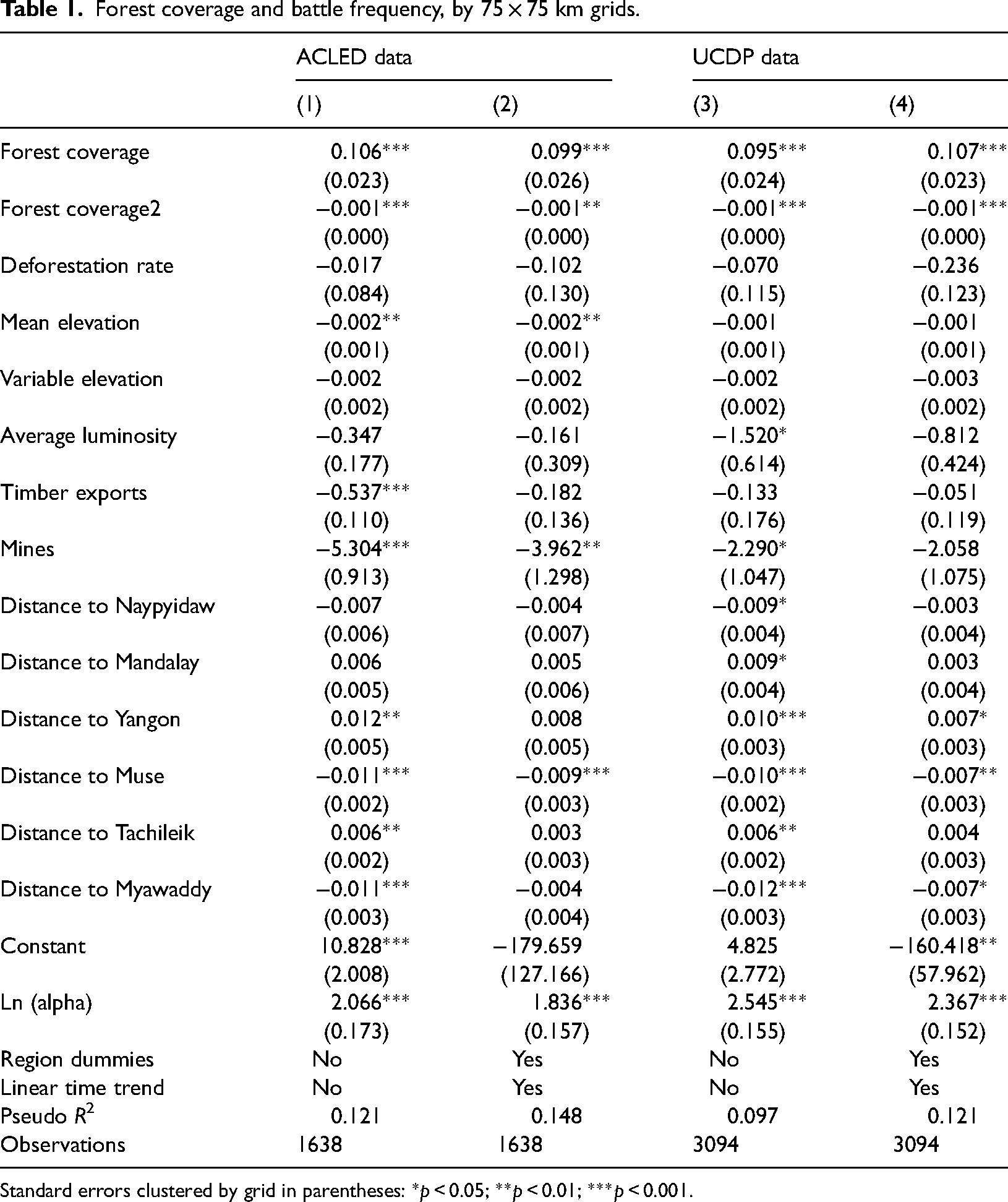
Standard errors clustered by grid in parentheses: *p < 0.05; **p < 0.01; ***p < 0.001.
Before moving onto substantive effects, we briefly discuss the control variables of interest. First, deforestation appears to have a negative effect on battle incidences, although this effect is not significant in all models. The night luminosity measure is not statistically significant in all except one of the model specifications, while the presence of mines is negatively correlated with battle incidents but is only significant for the ACLED data. This result is not too surprising as many of the mines that still retain precious gemstones may be more thoroughly controlled by and defended by the Myanmar government, making it less likely that insurgents will contest those areas. Distance to the Chinese border crossing at Muse is negatively correlated with battle incidences, which suggests that geographic proximity to the Chinese border increases the likelihood of insurgent activities, which is consistent with border regions as locations of insurgencies (Salehyan, 2007). In contrast, distance measures to the two main border crossing towns with Thailand, however, show inconsistent border effects. Moreover, our results remain consistent with the inclusion of control variables, state conflict dummies and time trend variables.
Given the non-monotonic relationship between forest coverage and battles, we plotted the marginal effects for forest coverage, as well as for mean and variable elevation. Figure 2 presents these marginal effects for ACLED (top-half) and UCDP (bottom-half) data. The vertical axis displays the predicted battle counts, while the horizontal axis depicts the measure of interest. Because patterns between terrain and conflict are consistent between the two datasets, we will focus on the ACLED data. Figure 2a captures the non-monotonic relationship between forest coverage and battle incidences: greater forest coverage increases battle incidences, but this effect dissipates at higher levels of forest coverage. Specifically, a 20% increase in forest coverage from 31 to 51% coverage increases the frequency of battles by 41%, but the same 20% increase from 51 to 71% leads to a 6% reduction in battle frequency. That is, the positive effect of forest coverage increases at low to medium forest coverage but diminishes at medium to high forest coverage. We observe identical patterns for the UCDP conflict data in Figure 2d.
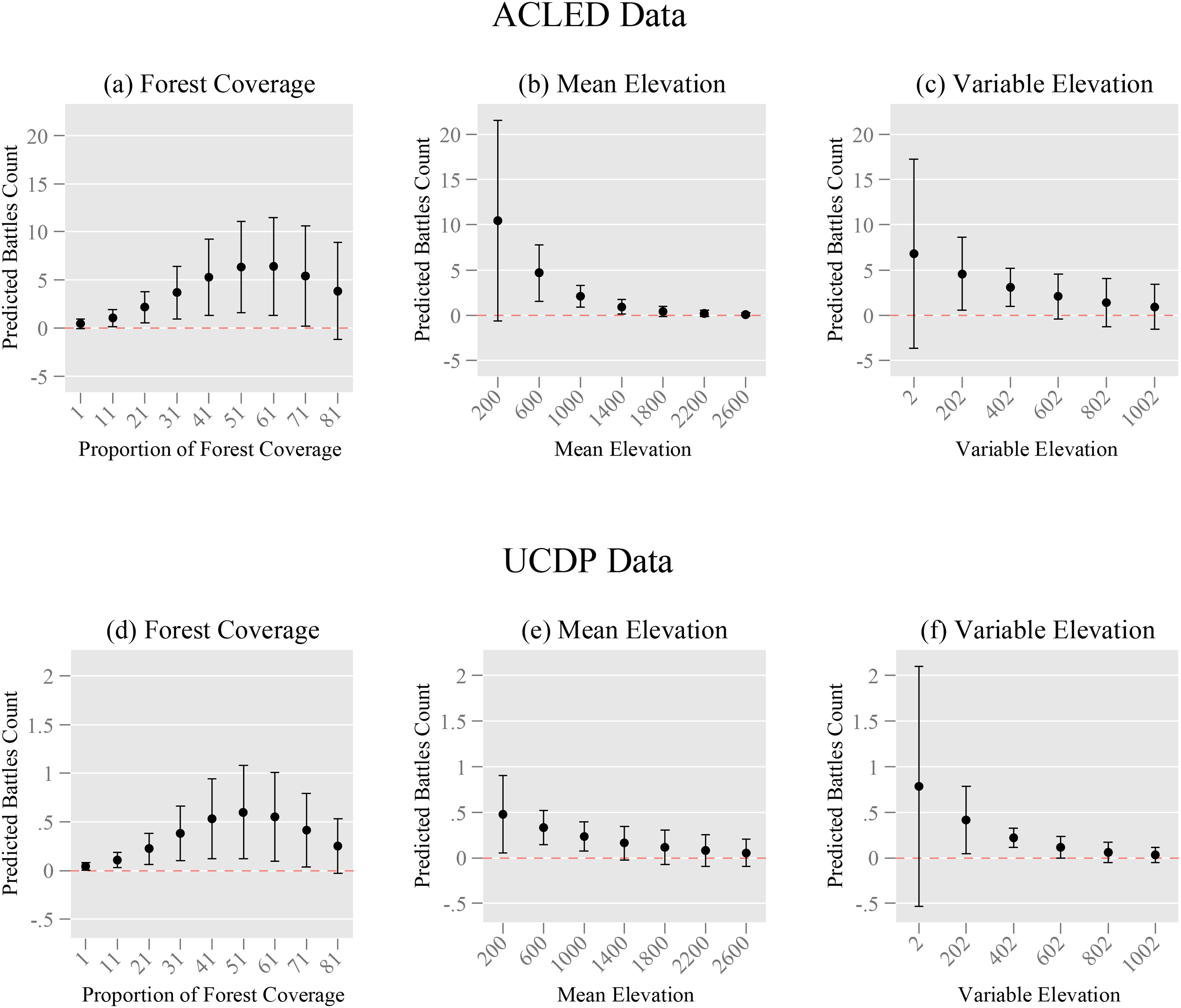
Forest coverage, mountainous terrain, and battle frequency.
In contrast, we found unexpected patterns in mountainous terrain as captured by mean and variable elevation. In both cases, predicted battle counts appear higher in less mountainous areas with lower average (Figure 2b) and variable (Figure 2c) elevation. This same pattern occurs for the UCDP data as well (see Figure 2e and f). These mixed empirical results are consistent with findings by Buhaug and Rød (2006) but reject broader findings on ruggedness and insurgencies found in Carter et al. (2019). To reconcile these findings, we investigated the mechanisms behind optimal terrain, specifically, whether such terrain offers a tactical advantage in the battlefield or a haven from which to launch strikes against state security forces. We also explored the intersection between forest coverage and mountainous terrain.
Optimal battle locations as safe haven or tactical battlefield advantage
Forest coverage offers two benefits to insurgents: a shelter to launch attacks and tactical advantages on the battlefield itself. Separating these two mechanisms is challenging because the location of local support bases is hidden, which conflates the two mechanisms in empirical analyses. To address this issue, we borrow an approach from Linke et al. (2017), who use rugged terrain spillover effects from neighboring regions. In their study, battles initiated by insurgents in location i were more frequent if neighboring j areas were more mountainous. The neighborhood effects suggest that the rugged terrain in neighboring areas provides logistical support to insurgents, but not a tactical advantage in the battlefield itself. Building on this logic, we use a structural spatial regression model to investigate how forest coverage in grid i and neighboring grids j affects the outbreak of battles in location i. Battles that occur in heavily forested areas in grid i would correspond to the tactical advantage mechanism as it is the immediate location of battle while battles affected by heavily forested neighboring grids j reflect the shelter mechanism, which provides supplies and lines of retreat for insurgents. 24 Because the spatial aspect of the analysis requires more accurate battle locations, the size of the areal scale could affect the difference between the tactical advantage and shelter mechanisms. For example, areal scales between 50 × 50 and 75 × 75 km grids generate nearly 3000 km of difference in distance. Therefore, we analyze the results using multiple areal scales with the expectation that at higher areal scales, the tactical advantage and shelter effects could potentially merge in spatial settings. For this reason, we display the results at three areal scales: 50 × 50, 75 × 75 and 90 × 90 km grids. 25
Table 2 displays the results of the spatial regression analysis, which requires interpretation of the direct, indirect, and total effects (LeSage and Pace, 2009). 26 Our findings support our hypothesis that forest coverage has an inverted U-shaped relationship with battle counts, indicating the presence of both tactical advantage and shelter effects. For example, in column (1) for the 50 × 50 km grids, each percentage increase in forest coverage leads to a 1.4% increase in battle frequency, supporting the tactical advantage mechanism. However, this effect diminishes as forest coverage increases, indicating a threshold beyond which the tactical advantage is no longer beneficial. In contrast, the direct effect shows a larger substantive effect, with a single percentage increase in forest coverage leading to a corresponding 324% increase in battle counts. This massive difference between the direct and indirect effects suggests that the logistical benefits of forested areas are more important to insurgents than tactical advantages. Column (2) shows qualitatively similar effects with respect to the UCDP data. 27
Spatial neighborhood effects between forest coverage and battles.

Robust standard errors clustered by grid in parentheses: *p < 0.05; **p < 0.01; ***p < 0.001.
As we increase grid size from 50 × 50 to 75 × 75 and 90 × 90 km, respectively, the substantive impact of direct and indirect effects increases, along with the standard errors. This increase in precision results in better accuracy since larger grids contain more data. However, the indirect effects generate more noise. For example, the p-value for indirect effects for the 75 × 75 km grid (column 3) is smaller than that for the 90 × 90 km grids (column 4), which is not surprising as the distance covered between tactical advantage and shelter effects overlaps with larger grid sizes. This effect is more pronounced for the noisier UCDP data with no significant indirect effects (see columns 4 and 6). Overall, our results suggest that greater forest coverage non-monotonically increases battle frequency through tactical terrain advantage (direct effect) and as shelters for insurgents (indirect effect), with the latter having a larger impact on battle frequency. However, mean and variable elevation appear to be either negative or insignificant. To further understand why mountainous terrain does not play an independent role, we investigate the relationship between mountainous terrain and forest coverage by interacting these two variables. 28
Figure 3 shows the interaction between forest coverage and mountainous terrain at different mean elevations. 29 Each subfigure of Figure 3 depicts the predicted battle count on the vertical axis and the percentage of forest coverage on the horizontal axis. The subfigures are divided according to specific mean elevation levels by the percentile in the distribution. These results reinforce our main hypothesis: battles between the state and insurgents are least common with the combination of the two extremes of mountainous terrain and forest coverage. At very low and very high mean elevation and forest coverage, battles are not common. For instance, Figure 3a illustrates that, at a mean elevation level of 90 m, no amount of forest coverage encourages insurgents to engage in conflict with government forces. This pattern is consistent for mean elevation levels up to 525 m (see Figure 3b through 3e). However, beginning around 780 m, forest coverage between 21 and 71% coverage increases battle frequencies (see Figure 3f). This effect becomes more pronounced at elevation levels of 972 m (see Figure 3g). Indeed, the inverted U-shaped pattern between forest coverage and conflict is prominent at these elevation levels, with battles initially increasing with forest coverage but diminishing at higher levels of forest coverage (see Figure 3i).
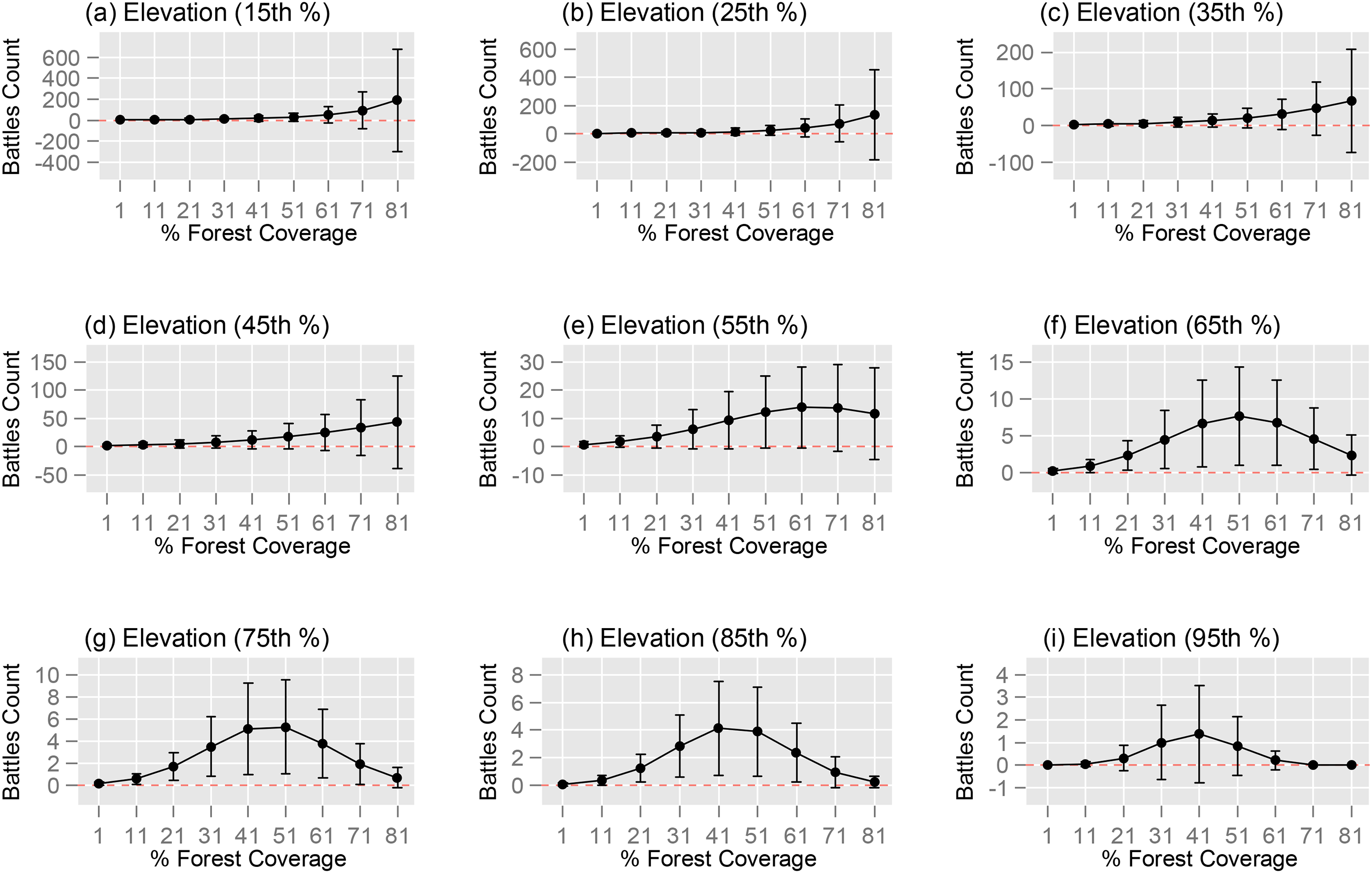
Battle frequency, elevation, and forest coverage.
For example, the Kachin state has three times more battle incidences than the average, and in this state, 75% of the area has forest coverage between 20 and 88% with elevation levels between 780 and 1130 m, which mirrors the conflict pattern seen in Figures 3f–h. 30 We conducted a similar analysis using variable elevation, and the results were qualitatively similar (see Appendix A4 for more details).
These findings support our hypothesis that insurgencies occur in areas with optimal topographies, where rebels can maximize battlefield advantages and are in proximity to their shelters. By interacting the inverted-U shaped relationship of forest coverage with mountainous terrain, we are able to reconcile inconsistencies in the literature. Previous studies that separately analyzed mean forest coverage and mountainous terrain yielded inconsistent results, similar to Buhaug and Rød's (2006) study in Africa. Our results suggest that insurgencies occur in locations that provide access for long-term settlement, but are also challenging for the state to traverse (Carter et al., 2019; Shaver et al., 2019). In the most remote regions with extremely forested or mountainous terrain, the lack of battles provides further evidence of the non-monotonic effects of difficult terrain on civil conflict. Insurgents initiate fights in areas that offer the lowest operational costs to wage battles (Linke et al., 2012), which are often located at the optimal combination of forest coverage and mountainous terrain.
Alternative explanations and robustness checks
Several alternative explanations could be confounding factors for the relationship between forest coverage and the frequency of battles, such as illicit drugs, battles driven by specific geographic locales (e.g. Kachin), or temporal changes (e.g. the collapse of ceasefires). To address these alternative hypotheses, we check the robustness of our main results in Table 1 for a multitude of dimensions: different grid scales and administrative regions, additional control variables such as illicit drugs, opium and methamphetamine, spatial conflict spillover effects, and alternative model specifications. For example, using different grid scales such as smaller scale levels generated greater data noise caused by inaccurate reporting and the particulars of spatial clustering but did not broadly change our results (see Table A1 in Appendix A1). We also ensured that our selection of model specifications remained robust to alternative specifications. Consistent with the approach taken by (Christensen et al., 2019), we estimated the 75 × 75 km grids with an ordinary least squares regression of a logarithmic transformation of the outcome variable. The results remain qualitatively identical (see Table A3 in Appendix A3). We also checked for potential confounders such as illicit and legal economic activities driving conflict patterns such as opium, methamphetamine, maize price shocks, 31 rubber and timber exports, and the location of precious mineral mines (e.g. jade, gold, and others). 32 The inclusion of these controls did not change our results (see Table A2 in Appendix A2). Given the continuous transformation of the outcome variable, we also controlled for spatial effects such as accounting for neighboring conflict region effects (see Table A4 in Appendix A3). Finally, temporal effects such as collapse of the 2011 ceasefire were also tested in a variety of ways from the inclusion of a 2011-year dummy variable to split sample analysis, and the results do not change in these tests. Thus, the non-monotonically positive relationship between forest coverage and insurgency activity is robust to a variety of model specifications, additional variables, and multiple areal sizes.
Conclusion
With a large variation in forest coverage and mountainous terrain, Myanmar provides an ideal case for further understanding the role that rugged terrain plays in the broader civil conflict literature. This paper contributes to the studies of the specific ongoing domestic insurgency in Myanmar as well as the broader civil conflict literature by showing that optimal rugged terrain increases battle incidences as demonstrated by the inverted U-shaped relationship between forest coverage and battle counts.
The inconsistencies in the existing empirical literature on the effect of forest coverage on conflict are largely due to assuming a monotonically positive relationship between forest coverage and civil conflict (Rustad et al., 2008), which fails to distinguish the non-monotonic dynamics. Our paper addresses these shortcomings by specifying a quadratic form for forest coverage as well as investigating the interaction between forest coverage and mountainous terrain. Further, we distinguish the mechanisms of tactical advantage as opposed to shelter effects on forest coverage's impact on conflict using a spatial regression. Here, we find evidence of both effects with shelter effects making a larger contribution to battle frequency. This lends credence to the view that insurgents strategically select optimal areas of forest coverage to fight against more powerful and better equipped state forces.
These results are robust to a multitude of model specifications and different areal scales. Moreover, by employing different areal scales, we address problems that arise from data accuracy problems that prior studies could not tease out. Thus, our findings reconcile evidence between the large N studies and more qualitative studies by shedding light on non-monotonic and variable effects between forests and civil conflict. Instead of focusing on how armed conflicts affect land use patterns (Baumann and Kuemmerle, 2016; Landholm et al., 2019), our findings indicate that topographical features such as forest coverage also affect dynamics of civil war fighting. In terms of generalizability, our results would generalize to other parts of the world with tropical forest coverage such as Southeast Asia and parts of Africa and Latin America. For example, our approach can be used to analyze insurgencies in Thailand with 31.6% forest coverage, in the Philippines with 24.11% forest coverage, and in Colombia with 54.5% forest coverage. Of these three examples, Colombia is the closest parallel with insurgents, paramilitaries, and a large, illicit economy driven by drugs. Indeed, studies have compared Myanmar with Colombia given their similarity of illicit drugs and civil war dynamics (Jonsson et al., 2016).
Myanmar experienced a military coup in February 2021 and post-coup violence has extended beyond cities to forested areas with the intensification of fighting between ethnic armed groups with government forces, as well as among themselves. There has also been calls for civilian defense forces to be trained at military bases under control by these ethnic armed groups in heavily forest areas. Future research on post-coup violence and intensification of Myanmar's civil war would benefit from our study on the complex relationship between forest coverage, mountainous terrain, and mechanisms of rebel strategies.
Supplemental Material
sj-docx-1-cmp-10.1177_07388942231171334 - Supplemental material for Rugged terrain, forest coverage, and insurgency in Myanmar
Supplemental material, sj-docx-1-cmp-10.1177_07388942231171334 for Rugged terrain, forest coverage, and insurgency in Myanmar by Wilfred Chow and Enze Han in Conflict Management and Peace Science
Supplemental Material
sj-zip-2-cmp-10.1177_07388942231171334 - Supplemental material for Rugged terrain, forest coverage, and insurgency in Myanmar
Supplemental material, sj-zip-2-cmp-10.1177_07388942231171334 for Rugged terrain, forest coverage, and insurgency in Myanmar by Wilfred Chow and Enze Han in Conflict Management and Peace Science
Footnotes
Declaration of conflicting interests
The authors declared no potential conflicts of interest with respect to the research, authorship, and/or publication of this article.
Funding
The authors received no financial support for the research, authorship, and/or publication of this article.

Supplemental material
Supplemental material for this article is available online.
Notes
References
Supplementary Material
Please find the following supplemental material available below.
For Open Access articles published under a Creative Commons License, all supplemental material carries the same license as the article it is associated with.
For non-Open Access articles published, all supplemental material carries a non-exclusive license, and permission requests for re-use of supplemental material or any part of supplemental material shall be sent directly to the copyright owner as specified in the copyright notice associated with the article.
