
Abstract
This article aims to investigate the generative process of urban development using simulation methods. The open-source platform OpenSim was used to allow participants to build immersive virtual environments representing the ancient town of Hoian, Vietnam. Patterns and urban properties are implemented as rules of generative process in urban design. This research not only corroborates Alexander’s methods but significantly improves his and colleagues’ method in providing a clear approach in generative process in urban design. Through the immersive environment of OpenSim, communities are able to establish effective public participation in planning their neighborhood as well as build and test urban codes.
Introduction
Urban designers recognize the importance of legal tools in shaping the urban environment. Although planners and researchers exert considerable effort researching form-based codes (FBCs) as an alternative to conventional zoning, their counterparts—generative codes and the generative process (GP)—have not received sufficient attention. Nevertheless, researchers such as Besim Hakim (2008, 2014), Christopher Alexander (2002; Alexander et al. 1987), and Zeynep Toker and Kyriakos Pontikis (2011) have argued in support of the GP based on the virtues of coherence, human scale, flexibility, and the adaptability of the environment.
The GP is an underlying mechanism that creates traditional urban forms with qualities such as compactness, mixed use, and human scales (Alexander 2002; Hakim 2008). Michael Mehaffy (2008, 57) defined generative development as “the stepwise process by which a form might emerge from the evolutionary action of a group of collaborators.” Nevertheless, except for research conducted by scholars such as Hakim (1994, 2008, 2014), knowledge of the GP remains inadequate for the purposes of understanding and building the coherence of the built environment. The original study of the GP can be traced back as far as Patrick Geddes (1915) and Lewis Mumford (1961). The latter coined the term organic city to describe the type of urban settlement that incrementally evolved into a coherent configuration.
The GP is primarily defined in the context of traditional settlements. Researchers describe what has already occurred in urban environments; they can observe discrete events in the timeline of urban development based on historical records but can scarcely observe the actual unfolding of the process in time and space. In other words, archival research lacks a dynamic view of morphological transformation, and urban observers cannot capture a continuous evolution of the built environment over time.
This study employed OpenSim, an open-source platform operating as an immersive environment. Through their representation in OpenSim as avatars, the participants were immersed in a three-dimensional computer environment to simulate the virtual town of Hoian, Vietnam, based on its history and geographical accounts. This approach is the first to employ a virtual environment to test and experiment with the generative process. I have several objectives in using OpenSim. I use simulation to observe the unfolding of the GP in time. Through observation, insights into the dynamic generative growth are attained. Employing a simulation tool, this study investigates the continuous evolution of the GP. This work is innovative not only in terms of observing the dynamic unfolding of an urban form but also in its potential for code testing and the capacity for fine-tuning codes for urban design purposes. This research also offers opportunities to elicit public participation in urban design in more meaningful and attractive ways. Lastly, the research helps to answer an important question regarding the building mechanism of a coherent form of a city.
Using the case of Hoian to understand generative development in traditional cities, this research aims to answer the following questions:
Research Question 1: How did the generative process unfold, as revealed by understanding the properties and patterns operating in the immersive environment of OpenSim?
Research Question 2: Can the same generative rules create diverse and unified urban patterns?
Research Question 3: How do cultural norms serve as patterns in the generative process?
Background
Pattern Language
A pattern language is a spatial and social solution to urban design and architecture problems (Alexander et al. 1977). These patterns are organized in an interconnected and hierarchical system that allows for infinite combinations, also known as a pattern language. This idea originated from the classic article “A City Is Not a Tree” (Alexander 1965), which emphasizes the semi-latticed nature of a city. A collection of entities with this type of order, namely, a pattern language, has the capacity to adapt to local conditions. However, “[a] pattern language is more than just a pattern catalogue” (Salingaros 2000, 155); it supports the virtues of organic planning in that collective efforts produce a highly coherent structure based on sequential growth (Mehaffy 2008).
Salingaros (2000) argues that a pattern is a recurring solution to a problem in context. He further explained that “a pattern is a discovered solution that has been tested for some time, and under varying conditions” (154). He also clarified that, “In practice, pattern languages arise from the following two very different needs: (a) as a way of understanding, and possibly controlling, a complex system; (b) as necessary design tools with which to build something that is functionally and structurally coherent” (155). Noting the importance of pattern language, Salingaros wrote that, “Pattern languages encapsulate human experience, and help us cope with complexity in our environment” ().
Form, Language, and Properties
Alexander (2002) proposed that to build a coherent structure, it is essential to have a form language that cooperates with the pattern language. Closely aligned with Alexander’s approach, Salingaros (2008, 221) defined form language as the “particular and practical conception of tectonic and surface geometry,” or more simply, a set of geometric rules that govern a type of architecture. Both pattern and form languages must seamlessly connect to one another to build a coherent structure. Arthur van Bilsen highlighted that “a pattern language contains rules for how human beings interact with built forms, whereas a form language consists of geometrical rules for putting matter together” (in Salingaros, 2005, 211).
Through the spatial and surfaced components of form language, architecture provides its informational and emotional content to human beings. Each unique form language is the product of evolution through trial and error in construction, and it must rely on local context (e.g., materials, practical needs, and climate) to create form (Salingaros, 2008).
According to Alexander (2002), a pattern as a social and spatial organization is also a center—the field-effect zone that plays a significant role in organizing urban structure or architecture. Alexander noted the analogy between his centers and Whitehead’s building blocks of reality—actual entities that, according to Whitehead (1979, 18), “are the final real things of which the world is made up.” Therefore, a pattern language is a fine way to represent the reality of urban form. Whitehead’s actual entities (or actual occasions) are in a state of constant change through the prehension, or grasping, of other entities. This idea parallels Alexander’s thinking about the continuous improvement of the wholeness of built structure—property that was built on hierarchical centers embedded in one another. This wholeness implies a global connection to other entities while maintaining a high level of internal order and coherence within a structure itself (Alexander 2002).
On the right side of the diagram (Figure 1) are urban elements, including edges, paths, nodes, districts, and landmarks, as identified by Kevin Lynch (1960). These elements are carrying bodies or containers of properties. They are the abstraction of urban patterns. These urban elements are similar to Whitehead’s (1979) eternal objects. As used here, this term does not have religious or honorific meaning (Mesle 2008) but instead signifies that eternal objects are “pure possibilities” or potential events that are ready to become Whitehead’s actual entities. Thus, a pattern is similar to an actual entity. A pattern will enhance its coherence (or novelty, to use Whitehead’s term) through the process of grasping a form’s properties. To some degree, this process is equivalent to what Whitehead terms prehension. A collection of patterns creates a pattern language, which is similar to the collection of actual entities that Whitehead terms a nexus (i.e., a society of actual entities). A form language expresses itself in urban elements, in which properties reside (Figure 1).
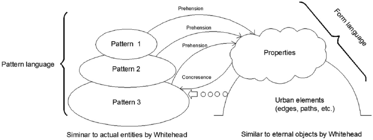
Relationships between patterns/actual entities and urban elements/eternal objects.
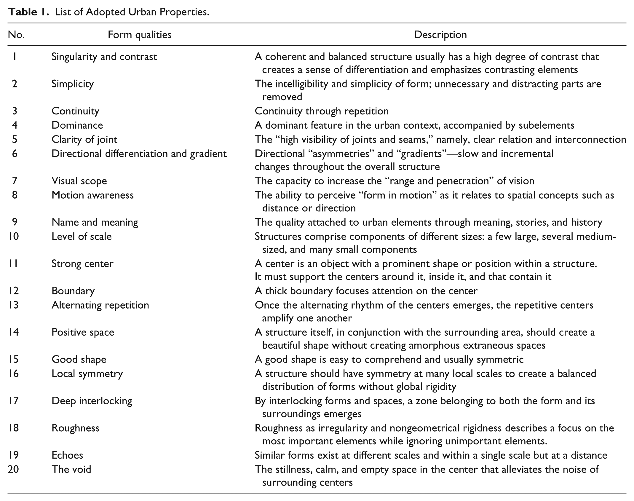
A pattern language must work with a form language—geometrical solutions to design problems—to produce good urban environments (Alexander 1979). In The Nature of Order, Alexander (2002) proposes the use of fifteen properties to express the quality of a built environment’s form. These properties are indicators of the wholeness of a form language. In general, the greater number of properties that exist in an urban element, the higher the wholeness of that element is. Nevertheless, although Alexander’s properties in a form language are useful for assessing architectural form, their applicability is limited on the urban scale, particularly when dealing with movement in a city.
In The Image of the City, Lynch (1960) discussed the qualities of urban elements. He coined the following terms: singularity, form simplicity, continuity, dominance, clarity of joint, directional differentiation, visual scope, motion awareness, time series, and name and meaning. His qualities of urban elements are useful for assessing a city on a large scale. In contrast, Alexander’s properties allow one to assess the level of coherence on a smaller scale. Combining Lynch’s qualities and Alexander’s properties aids in understanding and evaluating a city’s form on every scale, from small to large. 1 Table 1 lists these twenty synthesized properties. 2
List of Adopted Urban Properties.
The Generative Process
Hakim (2008, 2014) contributed extensive research on traditional cities in Islamic and Mediterranean regions, which he regarded as rich sources for studying the GP. He argued that the rules for these cities are meta-principles that encompass the ethical and religious values of Muslim societies, the balanced rights and responsibilities of public and private parties, and adaptive written codes.
Adopting a different approach, Alexander followed the process-oriented tradition of Jane Jacobs, utilizing the concepts of center and wholeness. A center, according to Alexander (2002), is a relational and organized space, a type of interrelated field of forces that acts throughout space. Each center has an adequate level of internal homogeneity and coherence that is typically shaped by a defined boundary. Alexander argues for the continuous improvement of the wholeness of built structures—a property that was built on the hierarchical centers embedded in one another. Wholeness implies a global connection to other entities while maintaining a high level of internal order and coherence for a structure itself (Alexander 2002). To quantify this wholeness or coherence, Bin Jiang (2015) proposes a measurement that he calls the Ht-index. According to Jiang, wholeness can be represented as a hierarchical graph in which nodes and links represents Alexander’s centers and their relationships. The Ht-index is a measure of a scaling pattern or recurring time comprising far more small things than large ones. 3
The “Cardboard and Wooden” Simulation by Alexander and Colleagues
Alexander et al. (1987) simulated a GP involving the redevelopment of the northern segment of San Francisco’s Bay Bridge. The general guidance for their simulation was the continuing improvement of the wholeness of the urban structure. Seven generative rules guided the simulation: (1) The urban structure must engage in incremental growth, (2) the process must enhance the growth of large wholes, (3) the process must engage participants with their vision at each step, (4) participants must create positive urban spaces, (5) participants must provide detailed layouts of large buildings, (6) detailed construction processes must be followed, and (7) participants should ensure the formation of centers at each step.
Nevertheless, the actual unfolding of a physical urban environment, a common issue in research on the GP, was largely unknown. For Alexander and colleagues, the simulation was based on their proposed rules. Their simulation allowed designers to observe the dynamics of the GP, but it was not based on historical facts that occurred “on the ground.” In contrast, in Hakim’s study of Arabic-Islamic towns, the GP is observed through historical materials and discrete events in the past. Nevertheless, the study is static. This research aims to address these limitations by providing a simulation based on historical facts—namely, a transformation of the patterns that actually occurred in a traditional city.
Computer Simulation of the Generative Process
Simulation has been used in urban planning and design for years. UrbanSim, one of the most well-known simulation tools, provides models that support land use and transportation planning and growth management (Waddell 2002). UrbanSim is a successful tool for predicting land use evolution. As an open-source land use modeling system, UrbanSim integrates with a transportation module to simulate urban land use, transportation, and environmental impacts (Borning, Waddell, and Förster 2008). The other well-known tool in the field of urban design is CommunityViz (Placeways 2015), which allows communities and laypeople to be involved in the planning and design process (Ben-Joseph 2005). One of the primary features of CommunityViz is that it assesses the impact of development projects on communities. The tool is “more visual, collaborative, and effective by providing capabilities for comparing land-use alternatives” (Ben-Joseph 2005, 163). Ben-Joseph (2005) thus argued that CommunityViz can help the planning process to become more democratic through informed debates. Recently, Synthicity (2015), a company founded by Waddell, introduced UrbanCanvas, a new tool that enables communities to participate in urban design. It is a visualizing tool for early-stage design.
In this paper, I propose deploying the GP in an immersive environment—namely, an interactive and computer-created world in which users can immerse themselves through avatars (Johnson 2010)—to observe how the GP unfolds and determine the potential implications of that unfolding.
The OpenSimulator (or OpenSim) platform used in this simulation was the open-source multi-user 3D application server OpenSim 0.6.7.1 developed by the Overte Foundation (2011). OpenSim was a sibling of the virtual commercial platform SecondLife (Linden Lab 2015). Except for some capacities that were not adequately developed because of licensing issues (e.g., voice chat), OpenSim has all the same functions as SecondLife. OpenSim has been used in education, archeology, and exhibitions (see e.g., Morgado et al. 2010; Sequeira and Morgado 2013). Nevertheless, the use of OpenSim has not been examined in the field of planning and design.
I employed OpenSim due to its numerous advantages. First, OpenSim is a user-generated content platform. In this study context, participants can improve the urban structure based on their vision and interpretation of the patterns and properties that I provided. The overall “content” involves the enhancement of the coherence of an urban structure. Although the goal (and content) is generally defined, it is implemented in flexible ways. This feature reflects the nature of the traditional building process in which human idiosyncrasies (and visions), not random variables, involved and guided evolution. The underlying idea of this simulation in OpenSim is to pursue values in urban design, thereby reflecting the normative nature of the urban design endeavour emphasized by scholars such as Jane Jacobs (1961), Lynch (1960), and Talen and Ellis (2002). This simulation avoids Lynch’s critique of value-free modeling. Second, OpenSim offers an immersive and interactive virtual environment that other simulation tools cannot provide. The unique qualities of OpenSim (and SecondLife), such as the sound, vision, realistic landscape, and awareness of each avatar’s walking movements, provides users with experiences in enriching and immersive ways that are similar to the real world (OpenSim’s term for being logged in is in-world). Third, simulating a historical town is similar to an archeological dig. The GP operating in OpenSim allows one to combine obscure historical facts within the virtual environment and to do so “interactively, piece by piece, like assembling a giant puzzle” (Sequeira and Morgado 2013, 8). This task is similar to how Morgan (2009) recreated archeological works at the virtual site of Çatalhöyük (Turkey). Similarly, the simulation serves as a “history laboratory”—a phrase borrowed from Sequeira and Morgado (2013, 9)—for reexamining historical events in the case study and placing them into the most reliable sequences. Finally, one characteristic that is unique to OpenSim compared to other simulation and visualization tools is its “gamification.” Researchers such as Sequeira and Morgado have argued that this feature helps participants engage more actively in virtual worlds compared with alternatives. In summary, the experiment in this study is closer to Alexander’s simulation than to UrbanSim or CommunityViz. To some degree, it is a human-based simulation.
Research Method
This research employed a mixed method that combined archival research with the human-based simulation. I used the open-source platform OpenSim to answer the first research question, “How did the generative process unfold, as revealed by understanding the properties and patterns operating in the immersive environment of OpenSim?” This platform allows researchers to observe the unfolding of the building process in an immersive environment. Participants implement the building process by employing the learned patterns and properties specified in the instruction manual. The result is based on the level of understanding of the form’s properties and pattern language. Second, the research question, “Can the same generative rules create diverse and unified urban patterns?,” is verified at the end of the simulation process. To answer this question, I create overarching generative rules based on incremental changes and patterns that participants should follow at each step. Finally, I answer the third question, “How do place-based norms serve as patterns in the generative process?,” by investigating historical facts and events that could be translated into cultural norms. Later, I select elements of norms—namely, social and spatial practices that have positive outcomes on the built environment—and build them as patterns. These patterns are later incorporated into a semi-hierarchical order to form a GP. 4 Cultural norms—or more precisely, place-based norms, a term coined by Eran Ben-Joseph (2005)—are building customs that shape the built environment. I combined historical events in Hoian that affected the built environment to patterns. For example, events such as changing the course of the Coco River or the establishment of the Central Market had significant impacts on Hoian’s landscape. These events are translated into patterns. Hence, my purpose is to investigate the following chain: historical events → place-based norms → patterns. I explored monographs, ancient maps, and secondary sources on the history of Hoian and then compared the principles of establishing the patterns of a pattern language devised by Alexander and colleagues.
Simulation in OpenSim
The GP in this study includes pattern and form languages. A set of patterns and its sequences directed the town’s spatial arrangement, whereas properties built on urban elements (i.e., paths, nodes, districts, landmarks, and edges) gave the town a specific form.
The simulation occurred from August 25 to October 11, 2014. Twenty-two participants who were architecture students from Danang University of Science and Technology in Vietnam generated the virtual development of Hoian in OpenSim. I organized in-person meetings with the participants twice a week to receive feedback or provide additional information. Beyond the in-person meetings, the participants worked in-world (i.e., they worked online in OpenSim). The participants had to download the Singularity viewer software, developed by Sianna Gearz, which is the name of a SecondLife resident avatar (Gearz 2014). The participants used this viewer to connect to Hoian’s OpenSim server.
Terrain Building
Each region in OpenSim has a fixed dimension of 256 × 256 pixels. In this simulation, I established three groups of islands (or OpenSim regions). Each group comprised fifteen regions representing the landform of Hoian. To build the terrain for Hoian, I used Global Data Explorer from the U.S. Geological Survey’s website (U.S. Geological Survey 2014). Specifically, I used the Seamless Shuttle Radar Topography Mission (SRTM) 3-arc-second data from the National Geospatial Intelligence Agency (NGA), which provides high-resolution heightmaps for terrains outside the United States. The SRTM data were used to create digital terrain maps of the Earth’s surface with data points spaced every 3 arc-seconds (approximately 90 m) (Lloyd Reeds Map Collection 2015). Because Hoian’s landform between the seventeenth and nineteenth centuries differs from its current landform, I used multiple historical maps to adjust and generate the terrain that best represented Hoian’s topography during the researched time period (see Figure 2).
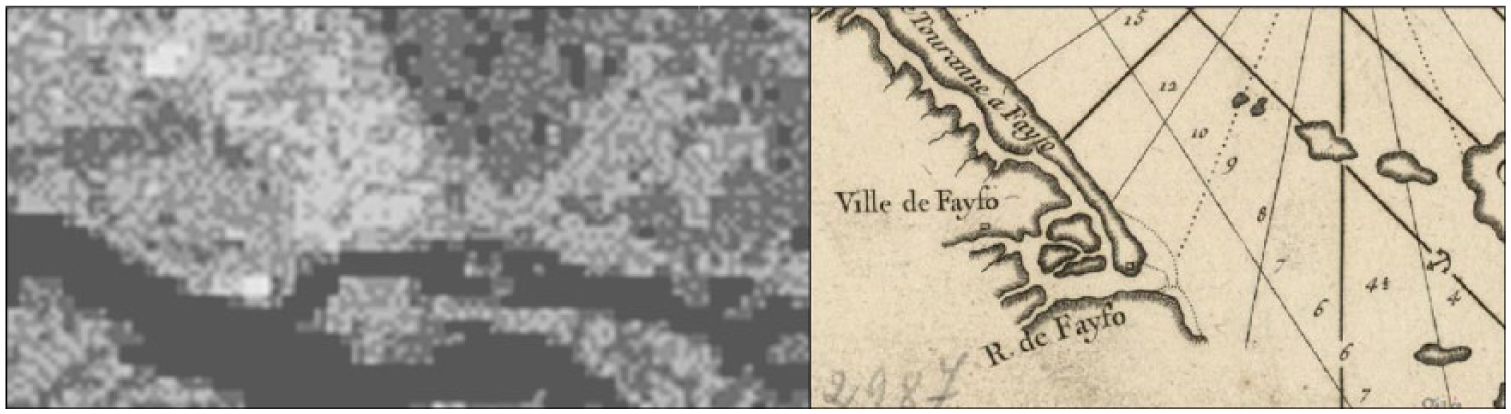
(a) The Heightmap of the Researched Area at 5120 × 2560 Pixels. This GeoTIFF heightmap was generated from National Geospatial Intelligence Agency’s Seamless Shuttle Radar Topography Mission. The black represents height level 0, and the lighter color represents a higher elevation. To increase legibility, I enhanced the map’s level of contrast. (b) The Hoian Region in 1745.
Because OpenSim uses only a square map of 256 × 256 pixels as its basic region, I divided the 5120 × 2560-pixel heightmaps into smaller square maps of 256 × 256 pixels. Fifteen maps of this size were arranged in three rows and five columns. This organization represents Hoian’s landform and imposed few constraints on the computer’s capacity. Notably, the simulated town is small relative to Hoian’s entire area (approximately 1 km2 compared to 20 km2). Therefore, if the main features of the regional landscape are respected, including a delta region, a lagoon-type estuary, and low and relatively flat terrain, detailed topographical features on a large scale do not affect the town’s structure.
The Participants
Twenty-two undergraduate architecture students from Danang University of Science and Technology participated in the simulation. These students were familiar with Hoian’s history and geography. The participants included twelve females and ten males with various levels of design experience (from second-year students to recent graduates). The participants were divided into three groups. Each group collectively built the virtual town of Hoian based on rules and guidelines that I provided in a simulation manual. Group two comprised participants with few design skills (the second-year students), while groups one and three included students with more advanced design skills.
The Participants’ Manual
I provided a working manual that guided each step of development. The manual format followed the spirit of building codes. Essentially, the manual describes the process of building the ancient town of Hoian via OpenSim. As mentioned earlier, each generative step in Hoian includes the following three parts: pattern, the form’s properties, and sequence (Hong Nguyen 2015, 2016). At each step, a pattern is built with appropriate properties. A sequence placed the appearance of patterns in appropriate order. All the patterns, properties, and sequences are based on historical facts for Hoian. Each pattern provides a spatial solution to the problem of Hoian, and the properties give the shape of that pattern. Each step in the manual could be considered a pattern building associated with the necessary properties (Table 2). During the simulation, I constantly provided the participants with feedback on their work and suggested refinements based on discrepancies between the qualities that were stipulated in the manual and the results in the OpenSim environment. Here is an example of steps four and six:
The Construction Steps in the Manual.
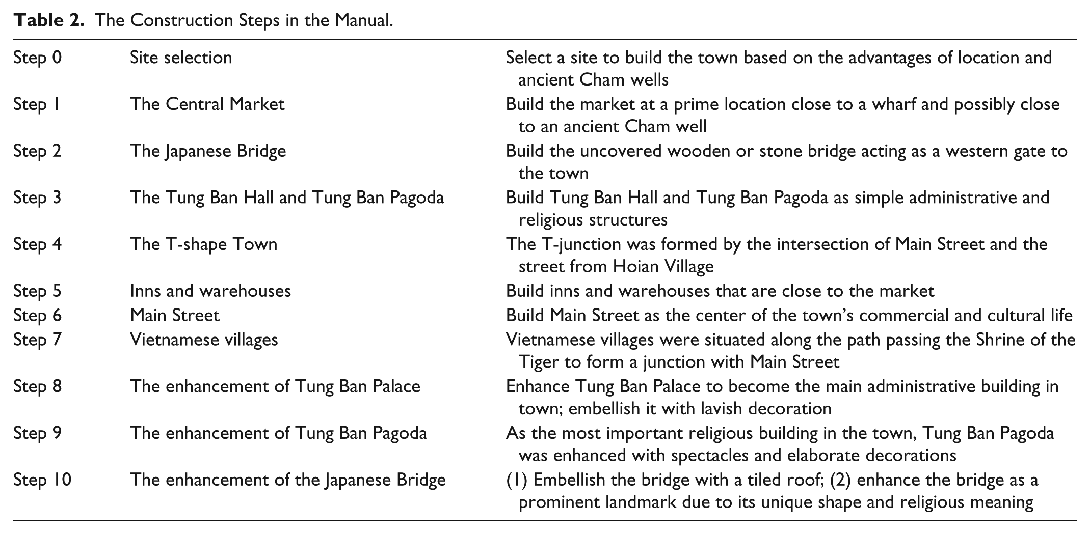
Step 4: The T-shape town The T-junction was formed by the intersection of Main Street and the street from Hoian Village. Tung Ban Palace was located at the corner of the junction. With the market across from the Tung Ban Palace and Tung Ban Pagoda on the other corner of the junction, this group of civic buildings formed the centre of the Japanese town. Step 6: Main Street Main Street was the centrre of the town’s commercial and cultural life. The street ran along the Thu Bon River and was flanked on the north side by cultural and administrative buildings, such as Tung Ban Pagoda and Tung Ban Hall. One- and two-story storefronts faced and rhythmically lined the street on both sides. The junction served as both a square and a gathering place for the activities conducted on Main Street.
The following excerpts from the Specification Manual describe how to build the Strong Center property:
Instruction: To obtain the quality of a Strong Center, you need to combine one or more of Alexander’s and Lynch’s properties, which include but are not limited to properties such as Thick Boundaries and Local Symmetries. Therefore, you should organize the urban environment following one of the properties discussed in the manual to build a strong center. The following recommendations are offered:
- Build Thick and Porous Boundaries by planting tree lines or rows of houses (with gaps between houses).
- Build the Dominance property by using the volumes of buildings such as Tung Ban Palace and Tung Ban Pagoda.
- Build Singularity and Contrast through the contrast between the Japanese town with the Vietnamese villages, the rice fields, and the surrounding woodlands.
- Build Alternating Repetition by repeating alternating elements.
- Build Positive Space through easily intelligible structures, typically convex or near-geometric spaces (e.g., closely shaped, such as squares or circles). You can use Nolli’s map of Rome as a reference on how to establish a positive space.
- Build Good Shapes through easily comprehensible shapes (i.e., typically symmetrical or nearly symmetrical).
- Verification: You should verify the structure that you created at every step. You should walk through the streets to get a feel for the quality of both the town and the Center. 5
Results
Overall, the simulation results showed that group one closely followed the manual’s instructions. The group’s participants understood patterns and their sequence and form properties. To some degree, the Japanese town simulated by group two showed less coherence in its urban form. Nevertheless, their town had the qualities of both clarity and clear orientation. Group three presented an interesting case; their town possessed a diversity of urban space that was reminiscent of Nolli’s 1748 map of Rome. From an aerial perspective, their urban structure could be perceived as the smooth flow of alternating closed and opened spaces. Nevertheless, when an avatar closely investigated the urban setting, he or she found that it showed a level of disorder, and the town structure lacked coherence.
Some common characteristics shared by the three groups included the following:
- Site selection: All three groups successfully selected the site for the town. However, the participants in group one paid great attention to factors determining the location of the Japanese town: close to the river, away from floods, in stable areas, and close to the ancient Cham wells. This group achieved the best site selection.
- A T-shaped town: All groups successfully built this pattern constructed by Main Street and the street leading to the Vietnamese villages.
- The Central Market: all groups not only successfully chose the site for the Central Market but also built the market with vivid feeling and detail.
- Tung Ban Pagoda and Tung Ban Palace: all Three groups built these two structures in diverse ways to represent the Japanese town’s civic center.
Furthermore, certain properties, such as Strong Center , Good Shape, and Positive Space, were well perceived and implemented by the participants, whereas other properties, such as Motion Awareness, Singularity and Contrast, and Clarity of Joint, were difficult to discern and implement. Overall, with different levels of understanding and adherence to patterns, pattern sequences, and form properties, the three groups built distinctive urban structures that characterized the potentiality of Hoian’s forms during the research period.
The following scenes illustrate the sequences of the town’s growth by the three groups.
Overall, group three generated a town with diverse spaces and good shapes that partially echoed the quality of famous traditional cities (see Figure 3). Nevertheless, this town configuration had several drawbacks; for instance, Main Street was overly broad, reducing the effect of the spatial enclosure. Furthermore, because the quality that an avatar perceived on the ground was the most important criterion for judging the urban form, among the three groups, group one created a Japanese town with the highest level of coherence and wholeness of urban form. The town’s Ht-index was the highest, and its urban space was also the most qualified (Figure 4).
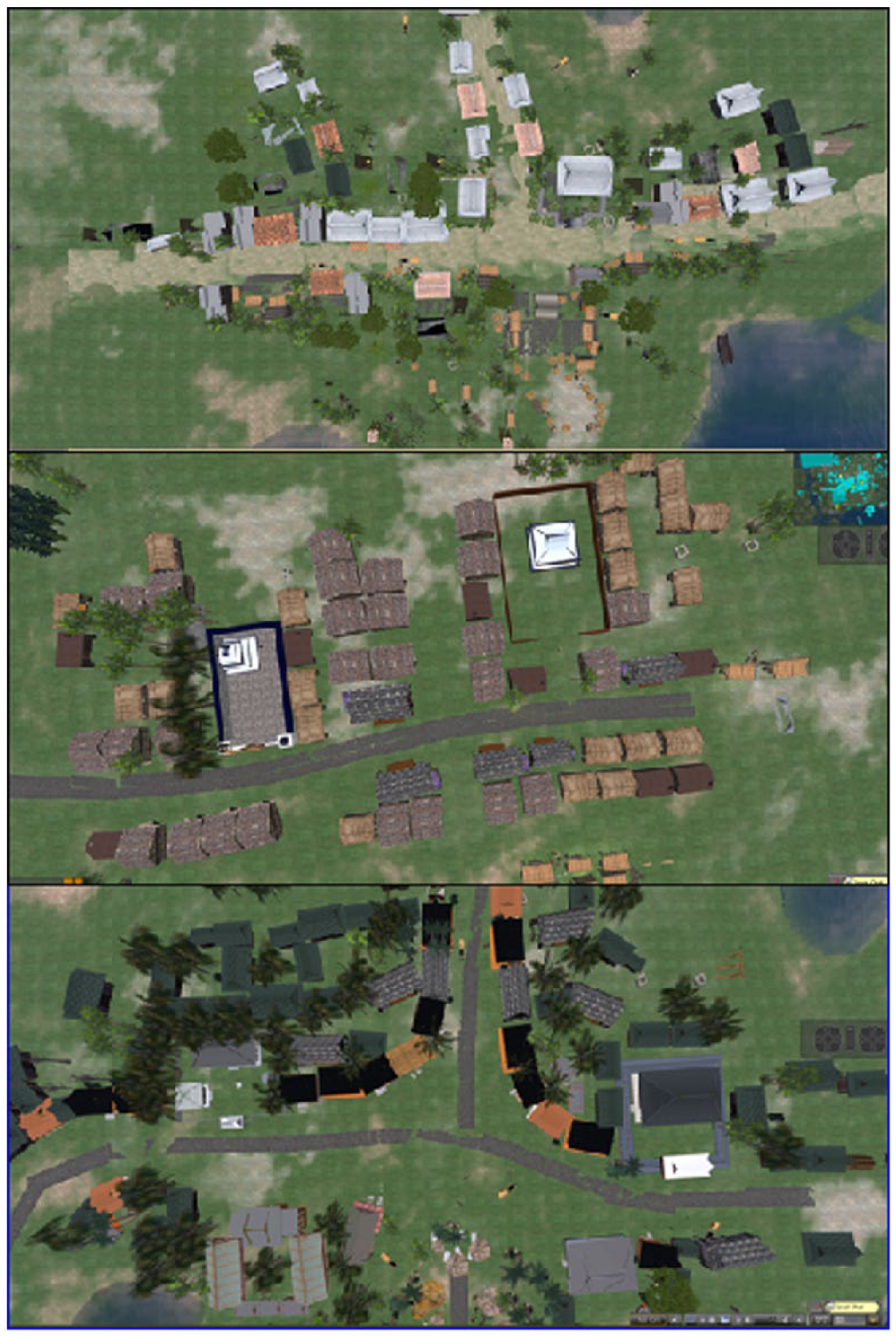
(a) Three simulated towns as the finished stage. Group one—the forty-seventh day of the simulation: a street view. An urban sense could be perceived when walking along Main Street from the town outskirts to the junction. 6 (b) Group two—the forty-seventh day of the simulation. The town had a clear sense of direction based on major patterns: the T-junction, Main Street, Tung Ban Pagoda, and Tung Ban Palace. (c) Group three—the forty-seventh day of the simulation: an aerial view. The T-junction and surrounding patterns: Tung Ban Pagoda, Tung Ban Palace, inns and warehouses, and the entrance to the Central Market.

The Ht-index and positive spaces between buildings in three simulated towns.
Discussion
The GP in urban design and planning has been addressed and investigated in various urban contexts (i.e., traditional and modern cities) and under different names (i.e., organic or traditional planning). Based on Alexander’s work on pattern and form languages, the open-source platform OpenSim was used in this study to simulate the unfolding of pattern and form languages in the ancient town of Hoian, Vietnam. Several findings emerge from this study. First, the study substantiates the proposition that one set of patterns and sequences can generate diverse built environments. Second, the patterns, pattern sequences, and properties of urban elements served as generative rules in creating a virtual urban structure.
The project outcomes reveal the diversity in the urban form of the three virtual towns. Although I expected differences in the forms of the three towns, the simulated towns’ levels of uniqueness, coherence, and completeness exceeded expectations. The three groups showed different levels of competence as each group’s perceptions of the form’s properties affected their results. The group that showed the most coherence in the virtual town was the group that demonstrated greater understanding of its properties. The results for group one were impressive, with a virtual structure that not only adhered to the patterns and the sequences but also achieved nearly all the properties stipulated in the manual. During group one’s town growth process, I observed the emergence of a coherent urban settlement. Although groups two and three were not as successful as group one, their virtual towns are poised to achieve higher levels of wholeness. For example, compared to the other groups, group three generated a town with a more diverse spatial structure. Group two could have built a more remarkable town if the participants had used appropriate frontage and appropriate properties, such as roughness and positive space. This finding implies that planners can adjust town structures by providing appropriate instructions; thus, a structure can be enhanced, even if it possesses minor flaws. 7 The simulation of repairing a given structure through the GP and codes in a what-if analysis can provide important lessons. Another issue is the level of understanding of a form’s properties and the pattern language affecting each town’s coherence. The future simulation should better train participants in working on urban properties and patterns.
The study substantiates many propositions. First, a pattern language has typically been regarded as a design solution. However, as shown in this and other studies (see e.g., Hong Nguyen 2015, 2016), a pattern language can be used as a systematic tool to unearth past urban structures, specifically, as a tool to generate knowledge. Second, the simulation reflects invariable qualities in the three Japanese towns—novelty, diversity, and coherence—at different levels, as expressed in the Ht-indices. Bin Jiang (2015; Jiang and Yin 2013) proposed using the Ht-index method to calculate the degree of wholeness for urban and architectural spaces. He argued that this method can prove that a space has the characteristics of coherence or life based on the Ht-index. The higher the Ht-index, the more coherent the space. By employing his method, I calculated the Ht-index for three simulated towns. I found that they share similar scores on the Ht-index. Group one’s town has an Ht-index of 5, whereas group two’s town has an Ht-index of 4, and group three’s town has an Ht-index of 5. Even though this approach still requires improvements, the effort to measure the coherence of an urban form is encouraged. The Ht-index’s calculation shows that the three towns that the students created achieved some degree of coherence.
In other words, the GP creates qualified environments, even when the participants have limited design skills. Third, the study reveals a new opportunity to use computer simulations to create and test urban codes. Planners can use OpenSim to build and test different urban form development scenarios based on different sets of rules. Researchers can also verify the strength and reliability of each property of a form language, thereby improving its properties. Finally, with proper preparation and minimal cost, laypeople can participate effectively in public design sessions such as charrettes—similar to the type of real-time design and visualization advocated by Ben-Joseph (2005). If such participation occurs, planners can satisfy the requirement of “engaging the public in the ‘code-making process’” (Talen 2009, 157). Furthermore, by educating participants with Alexander’s pattern language method and providing detailed manual instructions, stakeholders can build an urban form that follows the GP.
Conclusion
This research not only corroborates Alexander’s methods but also improves his method in providing a clear approach to GP in urban design. First, this research argues that as a practical matter, a GP will be employed in urban design. Second, it performs an in-depth exploration that reveals the following components of a GP: pattern language and form language and how these two languages can be implemented to produce a successful design. This simulation corroborates the conclusion from the other author’s research that the GP can give form to an urban environment without generative codes (as in the case of Hoian). Specifically, place-based norms, such as patterns, are the drivers of a city’s form. Through the enriched and immersive environment of OpenSim, communities can establish effective public participation in neighbourhood planning. This study also opens a new opportunity to use OpenSim simulation in testing and building urban codes.
The simulation results for the growth of Hoian between the seventeenth and nineteenth centuries suggest first that the same generative rules created diverse and unified built environments. Second, patterns, their sequences, and their properties should be implemented as rules of GP in urban design. This approach is different from the conventional method in which the entire urban form is planned at once. This approach recognizes patterns (of pattern language) and urban properties (of urban elements of a form language) as place-based norms, which in turn are the components and tools needed for the GP. Third, the OpenSim application (with its enriched and immersive virtual environment) facilitates public participation in design processes such as charrettes, in which communities engage in urban design through the code-making process. Finally, this study verifies the applicability of each property of a form language. The results indicated that individual properties have different levels of applicability and that the participants’ understanding of these properties greatly affects the coherence of the simulated town.
This research reveals a new opportunity for the task of code building and code testing. I suggest that an OpenSim simulation using the generative method can be applied to districts in today’s cities, which have comprehensible sizes and social and spatial complexities. Specifically, this type of simulation can be applied to designing and testing generative modules for the SmartCode, an urban code that helps categorize each type of development (Smartcodecentral.com n.d.). There have been calls for greater flexibility in building codes. Generative modules for SmartCode can respond to this call (Talen 2012). Thus, I expect that generative modules can be built and tested in OpenSim in a manner similar to the process used in this study. Code builders can use a what-if analysis to observe how generative modules actually operate in the SmartCode. They can use OpenSim to test and adjust the generative rules, find ways to improve them, and discard those that do not work. Nevertheless, there are several issues that future works should address. First, to make the work more practical, future simulation in OpenSim should incorporate Geographic Information Systems so that the results will be more applicable in planning and urban design tasks. Second, due to the variation of the coherence of urban forms in each town, a future simulation should use better documentation in the participant training urban forms’ properties and pattern language.
Footnotes
Acknowledgements
I would like to thank four anonymous reviewers for their very useful comments. I also would like to thank Emily Talen, my advisor at Arizona State University, for her encouragement on my work.
Declaration of Conflicting Interests
The author declared no potential conflicts of interest with respect to the research, authorship, and/or publication of this article.
Funding
The author received no financial support for the research, authorship, and/or publication of this article.