




Abstract
During the early modern age, La Caleta, as a strategic cove into the Bay of Cadiz, underwent numerous defensive improvements to protect the Cadiz emporium from possible attacks by other powers. These engineering works were to become a model for Spanish military architecture. The mobility of military engineers made significant contributions to reinforcing and upholding the Spanish Atlantic Bridge, not only through the Carrera de Indias, but also through the transmission of scientific and military knowledge, which was a major feature of Bourbon reformism. The multidimensional nature of this phenomenon is clearly illustrated by the fortification of Cadiz as the monarchy's main commercial port and naval base, which involved not only defensive improvements, but also aids to navigation – measures that were also applied in South American harbours during the eighteenth century.
Introduction
Since antiquity, the Bay of Cadiz has been a maritime point of reference owing to its location between the Mediterranean Sea and the Atlantic Ocean, as well as a fundamental stepping stone between the European and African land masses, joined by the American continent from the fifteenth century onwards. This maritime space, which can be considered a homogeneous geographical and anthropological unit, and which has witnessed intense maritime traffic since antiquity, has marked the history of the city and its interior. As for the nautical and defensive architecture, other Atlantic cities have been paid more attention than Cadiz in the early modern age – for example, with the works of José Antonio Calderón Quijano and Víctor Fernández Cano, or the more recent works of Gloria Cano Révora, María Pilar Ruiz Nieto-Guerrero and Juan José Jiménez Mata. 1 However, few studies have focused their analysis on the historical configuration of the city from a nautical point of view – that is, studying the land from the sea – a perspective that allows for a more global understanding of the historical evolution of the Bay of Cadiz and its foreland (America, Asia and Africa).
In order to adopt such an innovative approach, the global interdependencies forged between the coast of Cadiz and the rest of the Hispanic colonial empire (comprising communication, information, representation and logistics – factors that are often overlooked or studied independently) must be fully taken into consideration. The qualifier ‘global’ is made sense of by Cadiz's central role in the formation of links of mutual dependency between distant agents. From this point of view, the role played by Cadiz in the eighteenth century as the main gateway of trade with America cannot be overstated. However, this obvious economic importance was inseparable from the emergence of a naval node, which included such military institutions as the Royal Navy, the Captaincy General of the coasts of Andalusia, the political and military governments of Cadiz and El Puerto de Santa María, and the Royal Board of Fortifications of Cadiz, with jurisdiction over the whole Bay. Cadiz, a privileged maritime space, stands as a clear model of a maritime city that opened new horizons, knowledge and connections between the Iberian Peninsula, northern Europe, the American colonies, South East Asia and North Africa.
Taking into consideration the above, this work focuses on the analysis and projection of the defensive and naval model pursued by the Hispanic monarchy in Cadiz during the early modern age, with special emphasis on the area of La Caleta. We intend to analyse the defensive configuration of this outpost and the importance of the lighthouse as an aid to navigation – an integral part of a defensive system supported by the complicated natural system of entry into the Bay.
We shall begin by reviewing the existing literature, together with an examination of primary and cartographic sources mostly kept in the General Archive of Simancas, the General Military Archive of Madrid and the Provincial Historical Archive of Cadiz. From a historical chronological perspective, the following sections will address the architectural development of Cadiz's nautical infrastructure from the late fifteenth century to the defensive improvements brought about by enlightened policies in the mid eighteenth century. We believe that our conclusions will greatly contribute to a better understanding of the maritime military importance of early modern Cadiz, especially in the eighteenth century, and the historical and geographical implications of its global projection.
Controlling the Atlantic without forgetting the Mediterranean, 1400s–1600s
Although we know of the existence of watchtowers in the area of La Caleta since antiquity, the first hard evidence we have located for a tall construction on the crag of San Sebastián dates to 1475. 2 It is unclear whether the engineer Antonio Gaver took this information from Fray Jerónimo de la Concepción's Emporio de el orbe. In Chapter XIV of the seventh book, it is stated that some Venetian sailors found asylum on the island while suffering from the plague; in gratitude for the kind treatment they had been given, they erected a chapel to the patron saint of the plague there, and repaired the existing watchtower. 3 This suggests that the tower stood alone outside the city walls, although it remained connected to a network of towers that ran between the Sierra de Cádiz and San Cristobal in El Puerto de Santa María, and was likely similar to those used in antiquity to control both maritime and land routes. The construction of this tower system was probably triggered by the increase in commercial activity between the Mediterranean and the Atlantic, both on the European side and in Barbary. 4 These towers were likely aimed to send light or smoke signals to warn of the proximity of an enemy rather than to guide ships to a safe harbour. 5
However, it was not until after the discovery of America, when the Bay of Cadiz became the epicentre of trade with the new colonies and North Africa (the ‘privilegio rodado’ of 1493), that we find a request from the council of Cadiz to the Catholic Monarchs for the construction of a lighthouse in the city. The council argued that many ships had been lost at night, and decided to build the lighthouse in the tower of the church of San Sebastián to signal the coast and warn sailors of the proximity of the city. 6 In order to fund the construction of the lighthouse, the Monarchs decided to levy a series of taxes ‘on the masters and masters of carracks, ships and whips that traded in the ports of Cadiz and El Puerto de Santa María, fishermen and their boats being exempt from this measure’. 7 The arrival of ships laden with valuable goods and the increase in commercial activity mobilized ways to aid navigation – a development that was mirrored in American ports engaged in the Carrera de Indias, such as Havana. 8 This, however, also turned Cadiz and its hinterland into a primary military target.
It can be argued that, during this period, the existing defensive constructions were insufficient beyond the city walls, but the numerous raids launched against the Andalusian coast, and particularly that of Cadiz, especially by Barbary pirates, soon triggered the construction of a more solid defensive system. In 1554, the engineer Giovanni Battista Calvi built a defence system with bastioned fronts in the city, leaving all the territory to the west, Campo de la Jara and La Caleta, outside the perimeter walls. 9 A few years later, a plan was put forth to create a coastal network of 45 beacon towers, either new constructions or existing towers, reinforced to support artillery. Luis Bravo de Lagunas, who had suggested that the walls of Cadiz to the west be protected with towers instead of bastions, was put in charge of the project in 1577, and he set out to find the best locations for the towers and maximize their effectiveness (See Figure 1). 10
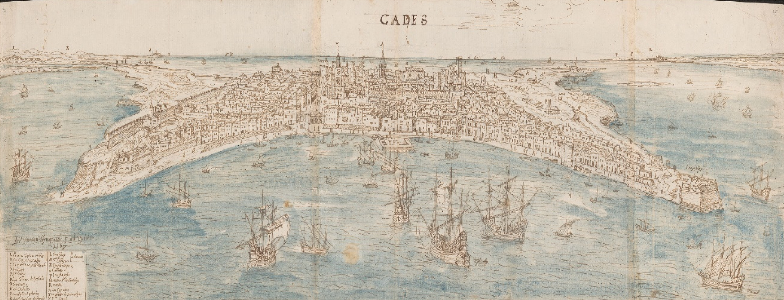
Engraving by Anton van den Wyngaerde, a painter in the service of Philip II, Cadiz, 1567.
The effectiveness of the defensive towers was, however, soon to be called into question, especially in Cadiz. According to Fray Jerónimo de la Concepción, despite the improvements undertaken in 1587, the tower collapsed after a storm and ‘because of the continuous rains, its artillery could not be used during the English invasion of 1596’. 11 However, the disaster of the city's occupation by the Anglo-Dutch fleet, when the possibility of abandoning Cadiz was even considered, highlighted the store that other European powers set by the Bay of Cadiz, and underlined the importance of this area not only as a commercial centre but also as a key logistical hub in the expansionist plans of maritime nations. 12 It was in this capacity that the commercial port and city flourished, capturing the long-distance trade flows that ultimately tipped the balance of economic power and stimulated urban expansion, sometimes leading to clashes between different competing urban groups. 13
Thus, after the occupation of the city, which revealed the inadequacy of its defences, Philip II ordered that Cadiz be substantially reinforced. 14 As pointed out by Alicia Cámara Muñoz, Renaissance-style fortification systems became a regular feature of the Hispanic Crown on both sides of the Atlantic – that is, both in America and in the Iberian Peninsula, particularly in its main harbours. This involved the creation of a sort of frontier, a display of political, economic and military strength before an ‘external foe from which only aggression could be expected’. 15
To this end, the Council of War sent the military engineer Cristóbal de Rojas to the city of Cadiz. Within days of his arrival, he issued a detailed report to the monarch on the state of the defences, which he considered insufficient and unusable. Among his proposals to improve the fortifications, he suggested the construction of a citadel in La Caleta. 16 However, Rojas’s plan was even more ambitious and, in addition to the construction of many new fortifications, he aimed to build a perimeter wall around the whole city – a project of an enormous scale. Consequently, ordinances were established to monitor the constructions and their quality, and to establish the hierarchy of the trades that were to focus their efforts exclusively on the royal work. 17
The defensive works in La Caleta, which was easily accessible by sea, began with the castle of Santa Catalina in 1598. It was built to a pentagonal plan, with a three-pointed star profile on the oceanfront and a straight wall on the landward side. One semi-bastion was built on each side of the entrance gate, which was situated at the centre of this wall, and a moat and drawbridge led up to the gate. Although many opposed the construction of a castle in La Caleta, especially among the city's authorities and residents, who thought the construction of a wall to be more appropriate, Rojas convinced Philip II of the importance of this fort, which would protect and facilitate the arrival of reinforcements to the inner city, and to the same extent would prevent enemy attacks on La Caleta and Rota. 18
Following this fortification policy, Juan Fernández Hurtado, the magistrate in charge of the Andalusian towers, began work on the tower system in 1611. Taxes on fish, at the rate of one maravedí per pound of fish unloaded at the coast, were to be raised to maintain these towers in good order. 19 The watchtowers of Santi Petri, Hercules and San Sebastián were within the city's jurisdiction. 20
The tower of Santi Petri and the new tower of San Sebastián were completed in 1614, and ‘a lantern was installed in the latter to signal the entrance to the Bay of Cadiz’ and the proximity of land, which was especially helpful on stormy nights, as noted in 1612 when Luis Fajardo's fleet was guided by a lantern placed by the field master Fernando de Añasco. 21 This was the forerunner for the modern lighthouses built later, whose lights had a greater range.
In accordance with Fernández Hurtado's new plan, the new tower that was built in La Caleta and described by Fray Jerónimo de la Concepción was oval in shape, and we believe that it was not attached to the church. 22 The floor plan was circular, and the profile was that of a truncated cone. Access was through the first floor at the end of a ramp that ran around the tower, and the ground floor seems to have been occupied by a chamber or semi-basement where we know that gunpowder was sometimes stored. A ladder led up to the next level, where a spiral staircase ascending to the upper floor began; access could thus be restricted by withdrawing the staircase. The floor was made of wooden planks and the room was put to a variety of uses. On the upper floor, which was reached via the staircase, at a height of about 15.5 metres, was the terrace, out of which the smoke escaped and where the lantern was installed. When the plan was drawn up by the engineer Antonio Gaver in 1766, 24 lamps and 4 stained-glass windows occupied two-thirds of the circumference at a height of about 19.4 metres. We believe that what is preserved today is the remains of the truncated cone-shaped structure; the structure currently stands at a height of 10 metres, and access is gained via an earthen slope that runs to the entrance door (See Figure 2).
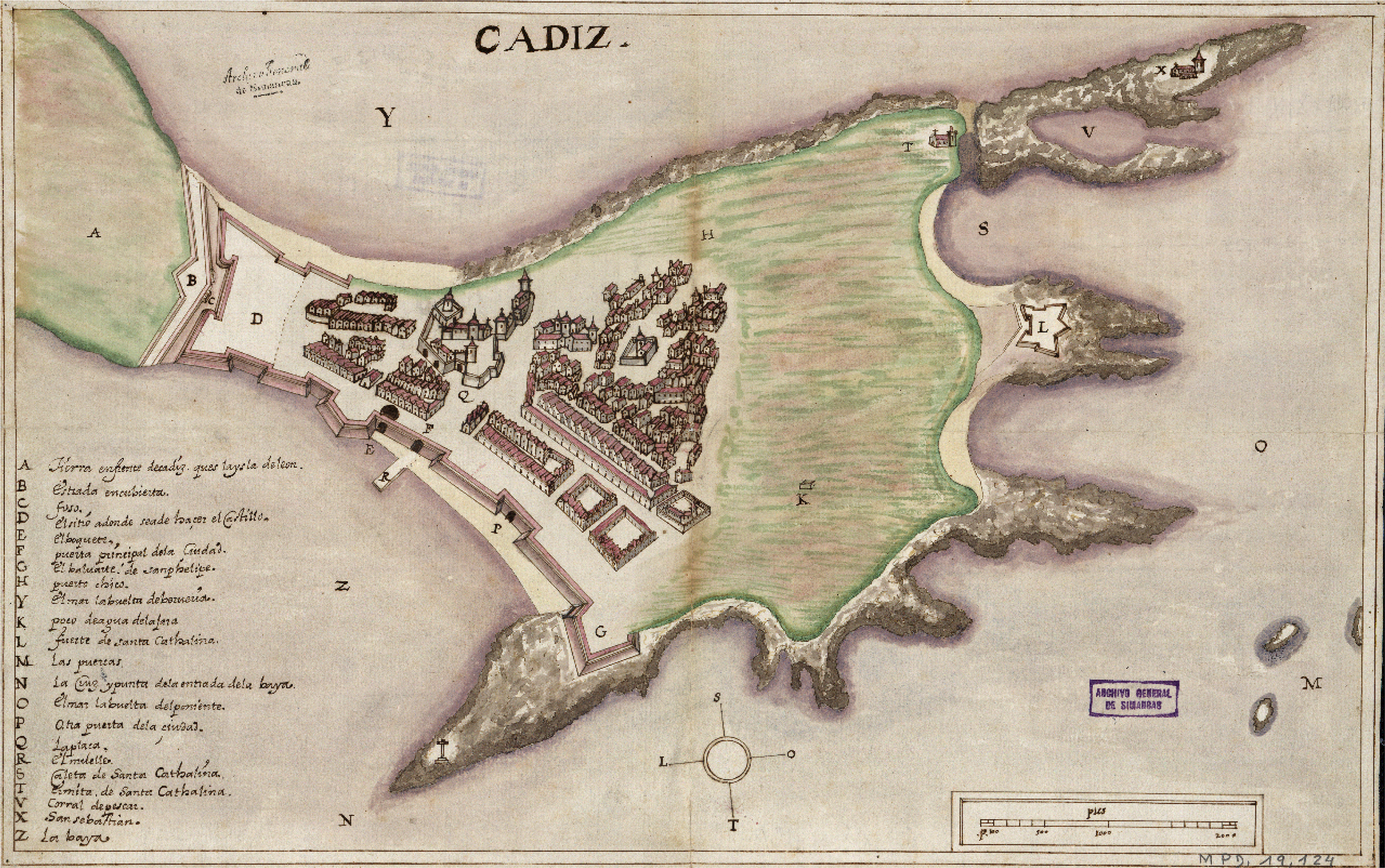
Plan of the city of Cadiz, 1609, with a description of the city and its defences.
In parallel with this military construction activity, the population of Cadiz increased in the first half of the seventeenth century, probably owing to the city's trade with America and the Mediterranean. The population swelled to 22,000 as the city grew and introduced improvements to its sanitation infrastructure. Streets were paved, water was channelled and new urban spaces were built, such as the Plaza de San Antonio. 23 This demographic and economic growth, which continued into the second half of the seventeenth century, sometimes strained relations between the military governor, who also presided over the civil authorities and was concerned about the city’s defences, and a wealthy and increasingly influential merchant class, who began to invest in new urban buildings, leading to the creation of new neighbourhoods such as La Viña from 1687 onwards. 24
In the late seventeenth century, the city's defences were extended in La Caleta de Poniente and on the Vendaval seafront; the coastal ravines were replaced by platforms and bastions on the wall. This accentuated the character of the city as an enclosed and militarized space, without suburban structures to buffer the transition into the surrounding countryside. 25 The city was now neatly outlined by a double perimeter wall, complete with a breakwater pier in front of the landward gate and another at San Felipe. These two elements were the earliest features of the city's full-circle defensive system. 26
Immigrants from other regions of the Iberian Peninsula and Europe settled in the city and its hinterland, lured by the economic opportunities and the chance of commercial profit, which led to a strong demand for labour. At the same time, an ever wealthier mercantile bourgeoisie continued to grow, fuelled by the rich returns of trade with both the Mediterranean and the Atlantic. 27 The city of Cadiz gradually became a key node for the economic and military administration of the Spanish monarchy and, as a result, its defensive and naval systems were ramped up to meet the new demands created by its leading role in the American monopoly. 28
Cadiz and the renovation of its defensive model during the eighteenth century
The consolidation, from 1680 onwards, 29 of the Bay of Cadiz as a de facto landfall area and naval base led to the strategic reinforcement of the area of La Caleta in the early eighteenth century. In 1706, the construction of a new fort began on the Peña de San Sebastián. The fort formed a nine-sided polygon with two drawbridges, and a tower and chapel of the same name stood on its north-west corner. The function of the fort was to control small boats or any types of vessels that tried to enter through ‘the entrance channel that was in front of the southern shore, helping the Vendaval batteries with its guns and barring La Caleta’. 30
The transfer of the Casa de la Contratación in 1717 was the final step in a long process that had begun in the previous century, which progressively turned Cadiz into one of the main centres of the so-called ‘Atlantic system’. 31 Although the economic foundations were already in place, it is also true that the move brought with it a series of cultural and naval institutions, which contributed to the creation of a ‘scientific’ Cadiz with global projection (the Marine Observatory, Midshipmen's School and Royal College of Surgery, for example). 32 In addition, other institutions related to the Naval Department settled in the Cadiz cove, such as the Arsenal of La Carraca, leading to military naval construction and the large-scale production of scientific information – a field in which competition between the European powers was fierce. 33
The reformist tide that was sweeping through the Bay of Cadiz also affected the concept of defence inherited from the age of Philip II. The old system urgently needed replacing with a more efficient model that responded to new strategic needs while adapting to the geographical characteristics of the region. As noted, in the city of Cadiz, the military and mercantile structures were closely related. Now, military engineers, a body that gained formal institutional recognition in 1711, also took control of non-military matters, leaving only urban projects to civilians. Thus, military engineers became a central component of the Royal Board of Fortifications, which was created in 1727 for the administration and collection of the taxes used for the construction of the walls and other fortification works in the city, the predecessor of which was the Board of Walls, created in 1687. 34 The Royal Board of Fortifications and its engineers played a prominent role in the urban planning of Cadiz, as the growth of the city involved the gradual occupation of land that was originally reserved for military uses. On the other hand, the sale of this land was a source of funding for the fortification works – another illustration of the symbiotic relationship between the military and the commercial classes. In the eighteenth century, periodic meetings were held to discuss issues related to the fortification of the city, which also addressed the best way to follow the royal orders regarding the city's ‘cordons’ or lines of urban expansion.
The castles of San Sebastián and Santa Catalina defended the entrance to the beach and, in the opinion of Ignacio Sala, the engineer in charge of the defensive renovation of Cadiz in the period 1717–1749, they offered good shelter and guaranteed the arrival of supplies in the event of attack. Despite being the potential target of enemy landings and bombardment from the approaches to the harbour – the outpost of San Sebastián, to the side of the tower, was particularly vulnerable in this regard – the early projects did not envisage increasing the fortifications’ firepower, estimated at some 17 guns. A major rehaul of La Caleta began in 1739, and the project was to make considerable progress in the second half of the eighteenth century. The Marquis of Torreblanca, in order to fence off a possible English attack from Gibraltar during the so-called War of Jenkins’ Ear, took into consideration a suggestion made by the Count of Roydeville, which involved creating a passage from the Caleta canal. The estimated cost was 6,021 reales de vellón, which were to be raised with the sale of the stone dug out for the canal, which was 200 toesas and 3 feet long. 35
One of the issues that concerned the engineer Ignacio Sala the most was a proposal to move the gate at La Caleta owing to the damage caused by the sea and the problems associated with high tides, which posed a constant nuisance for the nearby residents. The suggested new location was ‘where it used to be, next to the Chapel of Santa Catalina’, which would reduce damage and expenses. 36
Likewise, in the mid eighteenth century, projects were put forward to expand the city walls, build new docks and find room for the Casa de Contratación, Customs House and Consulate, as well as reinforce the castles and bastions. These were presented in several ordinances, in which the urban toponymy was carefully recorded. The primary aim of these projects was to improve the defensive standing of Cadiz in response to the gradual increase in the city's population, which by 1753 was estimated at 43,402. 37 In 1755, the Lisbon earthquake and tsunami caused widespread devastation in western Andalusia, triggering the dispatch of the military engineers Silvestre Abarca and Enrique Le Gallois to Cadiz. Their mission was to repair and reorganize the different layers of Cadiz's defensive belt. 38
One of the most significant changes in La Caleta during the reign of Charles III was the construction in 1766 of a new lighthouse on the foundations of the old one on the crags of the castle of San Sebastián. The entrance to the Bay of Cadiz was (and still is) difficult to navigate. The harbour can only be entered through a number of channels located between Cadiz and the town of Rota; these are flanked by rocky outcrops where ships often ran aground, a problem that was compounded by the accumulation of sediment brought in by the rivers that flow into the Bay. To alleviate these difficulties, a more powerful lantern was required, which led to plans for the construction of a higher and more effective lighthouse to prevent the recurrent shipwreck of vessels and fleets. 39
According to the engineer Antonio de Gaver, naval officers claimed that it was common for the lantern to be visible from no more than a league and a half away, and that at midnight the light tended to fade, possibly due to a lack of oil, which called the work of the lighthouse keepers into question. Furthermore, the superfluous masonry of the lighthouse obscured the visibility of two-thirds of the lantern. 40 It should be noted that the defensive and surveillance functions of the lighthouse were gradually lost with the construction of the castle in 1706, which was endowed with impressive defences and sophisticated ordinance. Likewise, the availability of new optical instruments, such as more precise spyglasses, and the information and flag warning system operated from the Tavira Tower further emphasize the diminishment in the relative importance of the lighthouse. 41
The new lighthouse that was to be built responded to the ideas prevailing at the time. The work of the engineers demonstrated theoretical and practical mastery over the scientific techniques that were typically being taught in academies organized according to Enlightenment models. 42 Therefore, the work of the military engineers was presented as a reflection of the power of the Crown, which in the Cadiz lighthouse was made explicit by the magnificent coat of arms of Charles III carved in the finest stone quarried in Malaga. On 20 October 1766, a public auction was held for the construction of the castle's lantern, which was intended to be at a height of 37 metres. The project contemplated raising an additional floor and lantern on top of the existing lighthouse; the work was completed on 7 December 1768. 43 In addition to the greater height and the three well-defined spaces, the structural variations included the extension of the spiral staircase, which, unlike in the previous tower, started on the first floor and went almost all the way up to the top (See Figure 3).
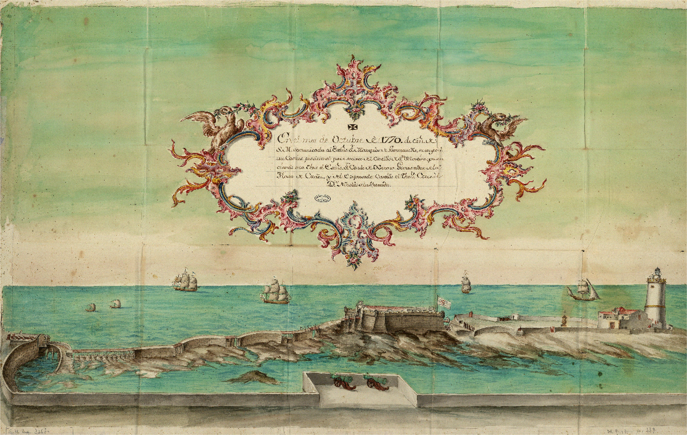
View of the castle of San Sebastián and the lighthouse of La Caleta, 1773.
On 4 November 1768, the 48 lamps of the new bronze lantern, which were theoretically visible from a distance of six or seven leagues, were lit, ‘having achieved their intended purpose … of ensuring the safety of vessels’, as stated in the initial project proposal. 44 However, it was not until 1794, following damage to the lantern a few years earlier, 45 that mechanical devices were installed to increase the range of the lighthouse, including springs, lenses and lamps with which to operate the eclipse–flash system that became the standard model in nineteenth-century lighthouses. The naval captain José de Mendoza los Ríos, 46 who was sent to Great Britain to collect information on the latest technical innovations in maritime lighting, pointed out that the lighthouse had 12 reverberations operated through an external automatic mechanism, which also gave the time of day. 47
The operation of the device installed at Cadiz was explained by Antonio Del Valle in a report attached to a letter sent from London by José de Mendoza los Ríos to the Havana consulate in 1795. Mendoza tried to convince the consulate of the benefits of the new model, and a similar one was installed in the Havana lighthouse for some 1,500 pounds sterling. He even proposed a series of improvements, such as the use of glass lenses and a reduction in oil consumption, with subsequent savings. 48
It was further noted that the lamps were a new model, known by the name of ‘Quinquet or Argand's Patent Lamps’; they had circular wicks that formed a hollow barrel, which caused a current of air to rise as they burned, feeding the flame, which was ‘extremely lively and smokeless’. Mendoza went on to explain that behind each lamp and on the inside of the triangle there is a large, concave and round reverbero, about two feet in diameter, made of a thin sheet of silver, perfectly burnished and strengthened on the outside with another sheet of copper [which reflected the light].
49
The professionalization and better training of the military corps also reached lighthouse keepers. In the case of Cadiz, we know that lighthouse keepers had been active without interruption from the reign of the Catholic Monarchs. The engineer Antonio Gaver proposed a series of improvements in 1768. 51 Gaver reported that, although it was manned by four keepers (with a salary of eight pesos each), the lighthouse was often not lit during the night, despite the fact that the keepers lived in an annex in the chapel of San Sebastián. He thus presented a series of proposals for the lantern to be better cared for. 52 However, the arrival of the revolving device a few years later demanded greater specialization from the operators and for their number to be increased. In 1794, Antonio de Ulloa took matters into his own hands and issued a 14-point set of instructions for the lighthouse keepers, with an emphasis on the most specialized tasks. Their duties were to include thoroughly cleaning the glass panes and mirrors; filling the oil deposits; lighting the lamps at sunset and stopping the device at dawn; crimping and securing ‘the axle wheel with the mobile machine to put the apparatus in rotation’; arranging the wicks; and caring for the auxiliary tools. 53 In essence, Ulloa's regulations remained in force until the 1920s, as later guidelines were heavily based on his.
This period also witnessed the expansion of the canal that connected the interior of La Caleta with the Vendaval Sea, which was, as noted, originally opened in 1739. Following the British blockade and bombardment of the city after the Battle of Cape San Vicente in 1797, the head of the city's fortifications, José de Mazarredo, together with the Lieutenant General of Engineers, Francisco Sabatini, decided to widen (to 12 yards wide and 400 yards long), clean and deepen the old channel so that, even at low and medium tide, the gunboats stationed in La Caleta could pass: [This] was already possible for many hours of the day and night … In view of this information, the king has resolved … to cease work in the canal if it appears to have been completed up to the point of the lowest tide … and that if it is not, to continue up to that point.
54
During the blockade, the city's light forces, made up of gunboats stationed in different positions, including La Caleta, fired incessantly at the British ships approaching the city, and were remarkably effective and difficult to sink due to their speed and size (See Figure 4). 55
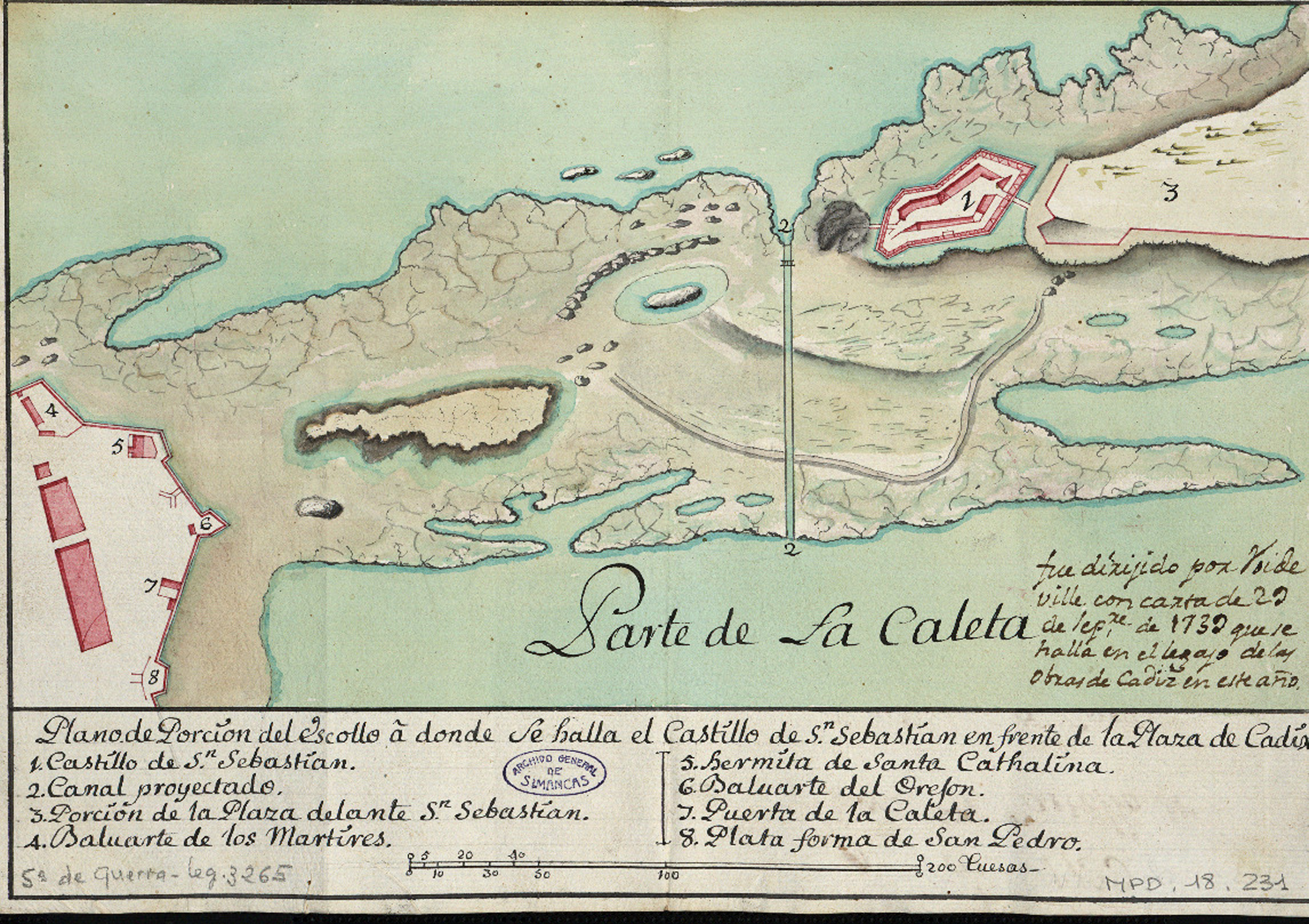
Plan of the channel in La Caleta (1739).
As previously noted, mention of the construction of a stable road between the Caleta gate and the castle of San Sebastián dates back to the first half of the eighteenth century, but the position of the reef between the two seas, meteorological conditions, danger of enemy occupation and excessive maintenance costs delayed the project until the second half of the century. We know that, in 1741, requests were made for the construction of several bridges to the castle of San Sebastián, with the argument that this would facilitate the defence of the city. 56 But it was not until 1771, under the threat of British attack, that a reasonably stable road was built. The bridge rested on piers set at 14-feet intervals, with the space between them being covered with 6-inch-thick iron planks, allowing ships to sail through. However, the planks were washed away by the first heavy storm. 57
However, a few months later, the engineer Juan Caballero informed Juan Gregorio Munain of the damage caused by the latest storm, including cracks in the walls on the Vendaval side and the front of La Caleta: [The] cracks are ever widening as the water batters them constantly, and it is not possible to fix them as time and tides prevent it. The storm has also carried away a sentry box behind the Cathedral, damaging part of the new road that is being built to the castle of San Sebastián, tearing out one of the Damas in the main moat, and blocking part of the one open in the castle's outpost.
Two years later, the governor of the castle, Nicolás de la Barreda, faced a new storm, which carried away up to sixteen of the boards that served as a path for supplies … and having collected the others that form the road, it is impassable even at low tide, because when the South [wind] blows they are hard to see, and consequently the time that can be spent [on the bridge] is very short. a road could be built … so that in all weathers and all tides, the free passage of people, batteries, ammunition, supplies and other things remains open, saving the continuous expense in wood and planks that cannot support the weight of mortars, cannons and carriages.
He pointed out that the existing road was good only for the transit of troops and other people for three months of the year, as the strong tides lifted the planks and dismantled them. 61 He suggested extending the area of the pillars to six varas to allow cannons to pass; reinforcing the existing structure by adding 19 new pillars; forming 23 arches to let the water through; and levelling the entrance to the Caleta gate to the height of the road. The proposal was harshly assessed by the engineer Juan Caballero, who argued that the screen formed by the road would not be able to withstand the onslaught of the water, as was the case with the Vendaval wall. He also pointed out that the cost of this work and the maintenance of the road would take up the entire budget for fortifications, without making the city or the castle impregnable, as the author of the project claimed. He stressed that raising and levelling the height of the road, in addition to being a difficult task, would incur enormous expenses. Furthermore, he stated that the current means of communication were sufficient and funds were scarce, although he admitted that cannons and mortars could not be carried by this road. 62 It is unclear whether this project was carried out, but we do know that the procession in honour of San Sebastián held on 29 December 1774 encountered some difficulties because storms had again left the path and some of the ironwork on the bridges in a damaged state. 63
We have to wait until the conflict with the British in 1797 to find a new report on the access routes to the castle. These records, which were addressed to the Count of Cumbre Hermosa, established that communication should be made possible at all times so that help could be provided in case of urgent need, while insisting on how difficult it was to do so by sea and to keep the land pass open. 64 At the turn of the nineteenth century, the sea continued its demolition work, and damage to the road was constant – neither timbers, anchors, piles, rows of masonry, iron staples nor rakes could withstand the onslaught of the water, and the expenses continued to mount. 65
In addition, a plan to build a hitherto non-existent drawbridge to connect the castle of San Sebastián with the stone road and the city was undertaken. This bridge had to be repaired repeatedly owing to the damage inflicted by storms and the clashing of British ships with the aforementioned gunboats. In fact, in June 1800, the engineer José Del Pozo complied a report on the state of conservation of the bridge, in which he requested 96,473 reales de vellón from the Spanish government to ‘repair the stonework on which the provisional wooden bridge which connects the city with the castle of San Sebastián is built. The deterioration of the pillars makes it quite urgent’. 66
The French illustrator Alfred Guesdon was to represent the urban majesty of Cadiz in an engraving, one of a series of urban views of Spain, in which the city is depicted as a first-rate naval centre and one of the most important commercial hubs in the world during the eighteenth century. The engraving highlights the importance of La Caleta at the entrance to the Bay, both as a defensive enclave and in its role in assisting vessels entering and leaving the harbour (See Figure 5).
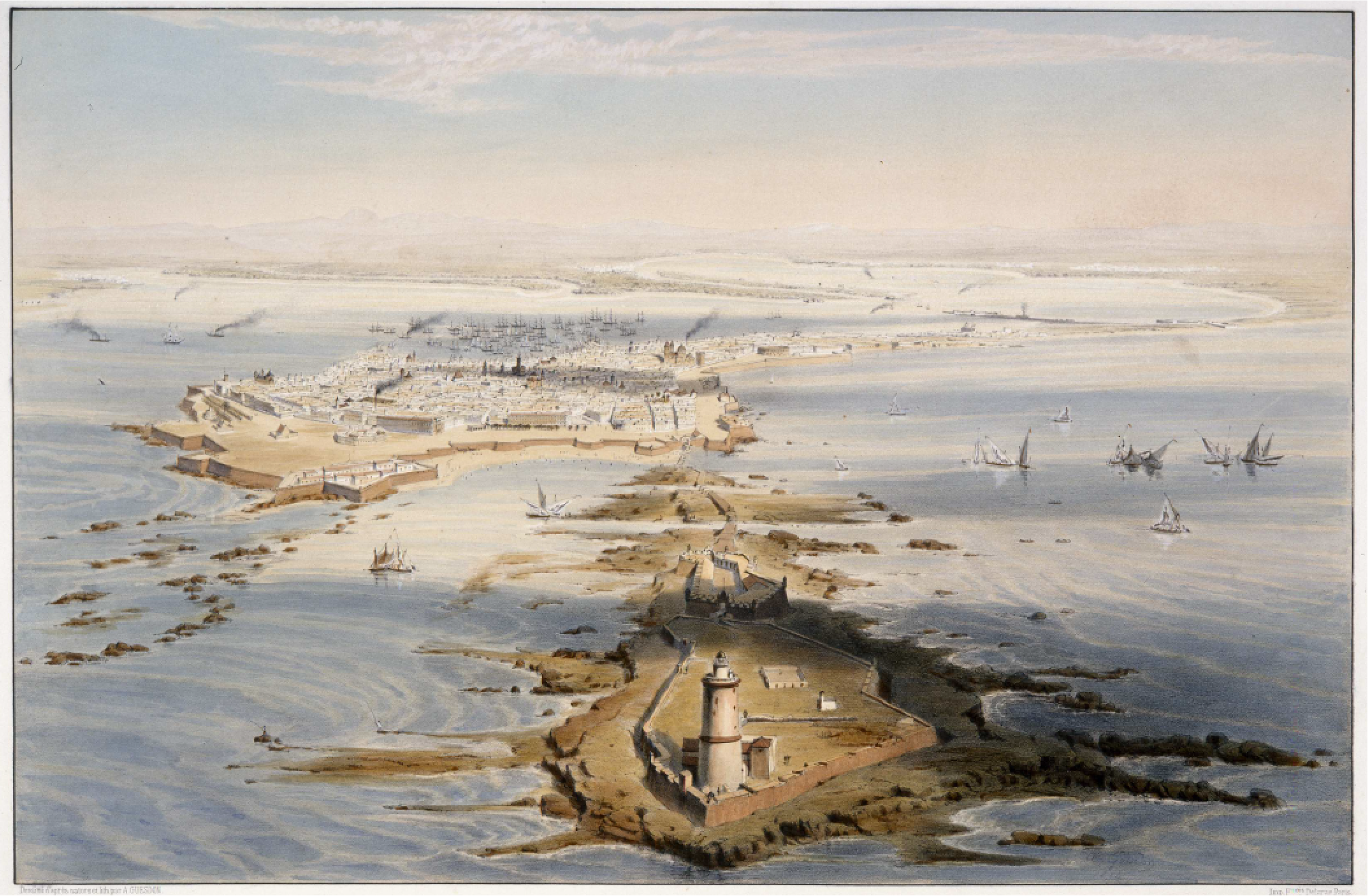
View of La Caleta by Alfred Guesdon, Cadiz, 1855.
Conclusion
The Caleta of Cadiz is a geographically and anthropologically homogeneous maritime space, whose nautical role has determined the history of the city and its territory since antiquity, and especially during the early modern age. Decades of terrestrial and underwater archaeological research, together with the written record, in our case concerning the defensive system and aids to navigation, have allowed a more global understanding of the historical evolution of the urban landscape to adapt to nautical and defensive needs. Beginning with the construction of a watchtower to control commercial traffic between the Mediterranean and the Atlantic in the final years of the late Middle Ages, La Caleta was soon fortified to reflect official concerns about the possibility of enemy landings, particularly after the discovery of America and the Anglo-Dutch assault of 1596. This was not only because Cadiz had become an important commercial enclave, but also because it was a strategic site for the logistics of the Hispanic monarchy. This led to the construction of the castle of Santa Catalina and the reinforcement of the system of defensive towers, with the lighthouse of San Sebastián playing a fundamental role both in terms of defence and as an aid to navigation for the fleets from the Indies as they negotiated the difficult entrance to the Bay of Cadiz.
There is no doubt that the arrival of the fleet at the end of the seventeenth century and the relocation of the Casa de la Contratación at the beginning of the eighteenth century only enhanced the strategic importance of Cadiz, and consequently the area of La Caleta. In military terms, the area was reinforced with the new castle of San Sebastián, the work of the Royal Corps of Engineers and the Board of Fortifications, which closely reflected the Enlightenment-inspired reforms being implemented at the time in both Spain and Spanish America. Also, as an aid to navigation, an enormous lighthouse was erected, which was 37 metres high and therefore visible from afar, to help ships enter the Bay. From a chronological perspective, it can be said that the naval and military imprint left on Cadiz was no more than a faithful reflection of the imaginary of power and propaganda mobilized by the Spanish Crown, which was in line with the political and military motivations of the European monarchies of the period.
Footnotes
Declaration of conflicting interests
The authors declared no potential conflicts of interest with respect to the research, authorship and/or publication of this article.
Funding
This work was supported by the Ministry of Science and Innovation of Spain, International Campus of Excellence in Marine Science (CEI.MAR; grant number PID2021-126850NB-I00, CEIJ-001).
