




Abstract
Planning scholars and practitioners know that planning projects and research are more likely to achieve significant outcomes when the problem is addressed at the most appropriate level of neighborhood. Selecting the right scale of neighborhood, however, is always challenging. To create conceptual framework for the choice of an appropriate neighborhood unit in future studies and projects, this article attempts to reveal a hierarchy of neighborhood and key elements for different levels of neighborhoods. The area, population, boundary characteristics, and key facilities for four levels of neighborhoods—face-blocks, residential neighborhoods, institutional neighborhoods, and community—are defined through the review of the literature on planning theory, guideline, and research on neighborhoods.
Keywords
Introduction
There is a long history of neighborhood studies, but recent interest has grown dynamically after people take more notice to advantages of neighborhood-based planning. Neighborhoods are the most recognizable and viable units of identity and actions to provide customized alternatives (Wellman and Leighton 1979; Martin 2003; Silver 1985). They also have the political capacity to protect the interests of the neighborhood and to explain what they need or describe any unwanted activities in the neighborhood. Future risk/benefits could be reduced/increased because residents identify neighborhood threats/assets in the early phases of the planning process. Neighborhood-based planning is more responsive to local influences since problems are small enough to effectively engage the participation of residents and local stakeholders.
In spite of these benefits of a neighborhood-based approach, delineating a geographically specified neighborhood is not an easy task (Chaskin 1998; Forrest and Kearns 2001). This is why the definition of neighborhoods varies considerably. It is generally said that neighborhoods need to be large enough to recruit participants and support services, while they remain small enough for residents to maintain a shared identity of neighborhoods (Weiss et al. 2007). In this perspective, the size of neighborhoods could vary from a few households to communities with thousands of people.
Different sizes of neighborhoods matter when choosing different planning tools. For example, economic development tools (e.g., tax incentive programs or special use packages for sports arenas, or specific industries) are unlikely to provide the best results for small scale localized issues. On the other hand, urban design issues (e.g., pocket parks, local playgrounds, and walkability) are more likely to be effective in local residential neighborhood settings. Research has a similar quality; if it is broadscale in nature, it is unlikely to detect issues of local interest. Conversely, detailed local analysis is not well suited for broad overview policies and issues. Thus, finding an appropriate level of neighborhoods and matching planning/research goals and tools to them is critical to achieve meaningful outcomes.
This research reveals the conceptual and operational framework of “neighborhood” as a hierarchy of levels through a brief review of planning theory, planning guidelines, and empirical research. Four unique and somewhat exclusive groups of neighborhoods are presented: face-block neighborhoods, residential neighborhoods, institutional neighborhoods, and community. Specific requirements in terms of size, population, available facilities, and boundaries are stated for each level of neighborhood.
Multiple Neighborhood Classifications
What Is Neighborhood?
Bowden (1972) mentioned that even eleven-year-old boys can draw neighborhood boundaries and have an awareness of the concept of a neighborhood. Scholarly description is more elusive. The previous literature provides insights into the conceptual nature of a neighborhood. an “important organ of urban life,” in which people are bound together, interlinked, and live interdependently like all living organisms (Mumford 1954, 260). a combination of geographical boundaries, ethnic or cultural characteristics of the inhabitants, psychological unity, or concentrated use of an area’s facilities (Keller 1968). a small urban area where residents are influenced by socioeconomic effects and services within (Goodman 1977). a subterritory of a larger area in which people reside and interact with each other (Hallman 1984). a geographical unit where inhabitants can share access to construction within (Chaskin 1997). a collection of spatially based attributes associated with clusters of residences, sometimes in conjunction with other land uses (Galster et al. 2001). a particular form of social reproduction where human activities, including daily life, social interaction, and political and economic commitment, take place (Martin 2003).
Synthesizing a shared notion, a neighborhood is a collection of people who share services and some level of cohesion in a geographically bounded place. Among three key words defining neighborhoods—people, place, and cohesion—place is the most noticeable term to distinguish neighborhoods from other terms like community. Community also refers to a group of people with a unity of values, beliefs, circumstances, interests, and culture regardless of geographical boundary (Chaskin 1997; Keller 1968). Neighborhoods, on the other hand, are communities with a more tangible and geographic concept that is useful for many planning purposes such as analysis, service, delivery, and intervention (Wellman and Leighton 1979; Forrest and Kearns 2001; Mullan, Phillips, and Kinman 2004). Hence, defining the geographical and physical conditions of a neighborhood provides the foundation for planning and research at the neighborhood level.
A Hierarchy of Neighborhoods
Depending on the size, level of cohesion, and services shared, neighborhoods are defined at multiple scales. Prior literature introduces a hierarchy of neighborhoods based on the criteria of physical conditions, social relationships, and political voice.
Physical conditions are the most often mentioned factors to clarify a neighborhood hierarchy. In the 1940s, Pan Nelson analyzed a hierarchy of neighborhood, in terms of the services provided, especially public education associated with the each level of neighborhood (Bailly 1959). Inspired by Perry’s Neighborhood Unit, Nelson introduced four levels of neighborhoods; each unit includes four or five geographically adjacent units of the lower level. A residential neighborhood is the smallest unit organized around children related facilities such as a nursery, play lot, parent education space, a social room, or convenience shops. It has a population of about 1,200. A neighborhood is usually organized around an elementary school with playgrounds, community centers, social rooms, or shops. A population of 5,000 is required. A district has a high school that are surrounded by playfields, auditoriums, gymnasiums, social and recreational facilities, adult education facilities, shopping centers, or health centers. The proposed population for this level of neighborhood is 25,000. A section is the largest. It is likely to have a junior college with a cultural center, social and recreational facilities, a civic administration center, or hospitals. The population at this level reaches 75,000.
Marans and Rodgers (1975) also used physical conditions and separated the neighborhood into three levels. A micro-neighborhood refers to a very small urban neighborhood with an immediate cluster of six or so adjacent houses. A macro-neighborhood is often characterized by an elementary school bounded by major thoroughfares. It is larger than a micro-neighborhood and is likely to be a planned community. Community is bigger than a macro-neighborhood and is frequently defined by a political jurisdiction.
The American Planning Association (2006), drawing from Chaskin (1998) and Suttles (1972), presented more explicit physical requirements for each level of neighborhood to operate in the planning process. Face-blocks are bounded within houses along with two sides of a street between intersections. Physical closeness of face-block neighborhoods encourages individual and interpersonal relationships, but it is not enough to expect broader influence in planning projects. A residential neighborhood consists of several face-blocks. A residential neighborhood usually shares amenities and services like, parks, civic spaces, commercial areas, and transportation access. It is a suitable planning unit to evoke direct participation from residents, but not appropriate for targeting broader system change such as economic development or institutional collaboration. An institutional neighborhood encompasses several residential neighborhoods. It is bounded by some degree of official limits of institutions. It needs to be big enough to provide multiple services such as schools, hospitals, clinics, government agencies, and financial institutions.
In addition to physical requirements, social relationships and administrative boundaries have been used to describe neighborhoods. Birch et al. (1979) noted and Galster and Hesser (1982) confirmed four levels. The primary neighborhood refers to a one-block radius around the home where children can play. It consists of a dozen or so dwellings. The secondary neighborhood is an area where residents have a relatively homogeneous socioeconomic status and feel “socioeconomic brotherhood.” This gradation comprises a continuous area of more than several blocks. A heterogeneous neighborhood shares means such as identity and facilities. It is often bonded by a shared name, school district service boundaries, or major transportation arterials. Heterogeneous neighborhoods comprise a group of several “socioeconomic brotherhoods,” but it could be seen as a different type of secondary neighborhood. Subareas of cities refer to larger areas that share an official identity such as suburbs, townships, or submetropolitan regions.
In a similar way, Chaskin (1997), drawing on Suttles (1972), divided the hierarchy of neighborhoods into four groups. A face-block refers a neighborhood based on a local network. Residents share the same local facilities and develop intimate or a simple recognition relationships. Thus, a physical boundary may not be sharply defined. A defended neighborhood is the primary unit where local identity and ties are nested. It is also called a residential neighborhood and is a “safe haven for their members” (Chaskin 1997, 536). The size of defended neighborhoods may vary. It could be a few blocks around a house or bigger, but needs to be large enough to provide daily services such as a grocery store or church. A community of limited liability possesses an officially recognized boundary designated by a municipal government or other institutions. Thus, it is also called an “institutional neighborhood.” This administrative unit provides various services that enable comfortable urban living. An expanded community of limited liability is a cluster of subdistricts and encompasses a relatively large area. It is often characterized by unique name, for example, Lower Manhattan or Harlem in New York city. The boundary could be clear or overlapped.
Focusing more on personal relationship and political voice than physical conditions, Jacobs (1961) proposed three levels of neighborhoods. Street neighborhoods highlight the acquaintances and personal relationships along with streets. Because of overlapping perceptions and personal relationships, the boundaries of street neighborhoods are not well defined. Even though it was hard to say which level of neighborhoods is more important, she highlighted street neighborhoods as the smallest but the most vital and effective self-governing units. A large district refers to an area with a recognizable name and consists of 100,000 or more people. Large districts have moderate political power to meet the needs of residents, visitors, and workers. The city as a whole is rarely referred to as a neighborhood. However, she assumed the city would be one of the neighborhood units having a complete range of services and common interests allowing people to associate with each other. She argued that bonding to the city as a whole is the greatest asset.
Four Levels of Neighborhoods
Existing literature introduces certain criteria that form a hierarchy of neighborhoods, while the classification schemes and nomenclature slightly differ. Four possible levels of classification could be suggested depending on their physical characteristics (e.g., size, local facilities, and recognized boundaries), composition of socioeconomic features (e.g., homogeneity/heterogeneity of income, life cycle, and ethnicity), and the degree of informal network.
Level 1: A face-block is the smallest unit that can be called a neighborhood. It refers to a cluster of several houses nearby that develops the closest bond. Informal and personal relationship is critical, but face-block is too small to organize a political voice. Thus, face-block is not usually an appropriate unit for physical planning.
Level 2: A residential neighborhood is composed of several face-blocks. Residential neighborhoods are relatively homogeneous physical and socioeconomic places. They are designed primarily as residential areas with similar street design and architecture. They often share similar housing values that serve people with similar incomes and life cycles creating relatively homogeneous ambience. It preferably contains one or two central activity point/points such as an elementary school or small retail store/stores that serve/serves daily needs of residents.
Level 3: An institutional neighborhood is comprised of several residential neighborhoods. It includes quite a range of functions like schools, health centers, recreational and social facilities, and shopping centers. It is often called by its own name and may have an official or an administrative boundary.
Level 4: Community is a cluster of districts of a city such as townships or suburbs, which cover relatively large areas; sometimes the area extends to the whole city. It is likely to have cultural centers, administrative centers, or colleges available to quite a large number of the population including residents and visitors (Figure 1).

Comparing relative levels of neighborhoods.
Neighborhood Requirements
The four-level categorization of neighborhoods can serve as a guide for planning and research projects, when enriched by theory, guidelines, and empirical studies. This literature does not articulate clear criteria for every level of neighborhood. To provide better clarity, this section assorts the neighborhood concepts appearing in theory, guidance, and research literature into face-block, residential, institutional and community level based on their descriptions, size, boundary, and core uses.
The Size of Neighborhoods: Population and Area
From theory
Garden City, an ideal city model proposed by Ebenezer Howard in 1898, has about 30,000 inhabitants with 6,000 acres of land. A specific neighborhood model was not proposed, but he emphasized the self-completeness of each section, called a “ward” that is a sixth of a city. A ward includes schools, religious institutions, or libraries in about 1,000 acres of land with 5,000 people (Howard 1965; Keller 1968). As he highlighted the complete town with various functions, a ward would be larger than residential neighborhoods. The discussion of ideal neighborhood models continued in the United States around the 1920s. In 1920, MacKenzie proposed the “Industrial Housing” model that has a similar composition to traditional neighborhoods with systematic greens, preserved rural lands, a neighborhood center, and main street (Rogers 2001). MacKenzie describes the residential part that also has the neighborhood center or independent central business area as a neighborhood; a series of these creates a town or a village. This neighborhood is consistent with a residential neighborhood due to a composition of land uses: a neighborhood center and townhouses, single-, and multifamily housing. The 1,350-foot radius (a quarter mile) encompasses a neighborhood, which is about 131 acres of land (Nolan 1927). Around the same time, Clarence Perry proposed the Neighborhood Unit theory. He suggested an ideal neighborhood size and design guidelines for residential developments in metropolitan areas. One hundred and sixty acres of land with 5,000 (up to 9,000) people was recommended to form a residential neighborhood. The value of 160 acres is derived from a five-minute walking distance (a quarter- to a half-mile radius) to an elementary school that is a central point of a neighborhood. Five thousand people is assumed to be large enough to support one elementary school and to form residents’ voluntary associations (Perry 1929; Lawhon 2009). A population of 5,000 might be originated from medieval quarters (neighborhoods), which had 1,500 to 6,000 people with a church in the center (Mumford 1954). Stein (1942) expanded Perry’s idea to a half-mile radius. He placed an elementary school and a small shopping center for daily needs in the center of a neighborhood. Three adjacent neighborhoods create a town, which supports one high school and one or two major commercial center/centers (Mumford 1954; Stein 1949). Stein’s neighborhood seems like a residential neighborhood encapsulating 500 acres of land and his town like an institutional neighborhood. Similarly, N. L. Engelhardt Jr. also presented different scales of neighborhoods in 1943 based on schools. He believed that the best education is the result of a well-conceived neighborhood plan and is critical in integrating the daily lives of residents. Engelhardt proposed a radius of a quarter-mile walking distance to a playground and a daily nursery and a half-mile as maximum walking distance to the elementary school (Gallion 1950; Bailly 1959). When a neighborhood defined by an elementary school, it has a population of 1,700 families. Considering the average family size of 3.76 in 1940 (US Bureau of the Census 2004), the suggested population for a neighborhood could reach 6,000 people. A middle/junior high school needs two neighborhood units (3,400 families, about 12,000 people) and four neighborhoods are required for a high school and commercial center (6,800 families, about 20,000 people). A community could be created with a population of 24,000 (Gallion 1950). One neighborhood seems to be a residential neighborhood, and two neighborhood units create a residential or an institutional neighborhood depending on the number and types of local facilities. Four neighborhood units are as big as an institutional neighborhood (Figure 2).
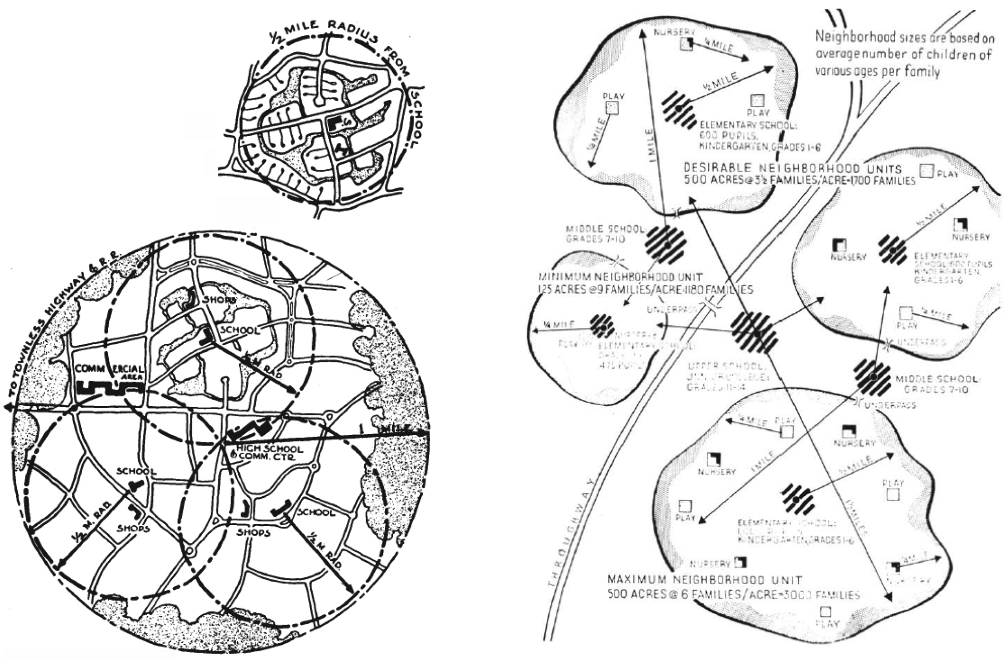
Cluster of neighborhoods: Clarence Stein (1942) versus N. L. Engelhardt Jr. (1943).
Even though Neighborhood Unit theory is still in dispute, it has given rise to an up-to-date neighborhood-based design concept. Threads of the Neighborhood Unit theory run through New Urbanism, including Traditional Neighborhood Development (TND), Transportation Oriented Development (TOD), and the urban village movement. Duany and Plater-Zyberk (1994) and Nelessen (1994) agreed with a five-minute walking standard, a quarter-mile radius, and proposed bus stops, parking lots, and a school in a neighborhood center (Farr 2007), while Calthorpe (1993)’s TOD neighborhood unit supported a ten-minute walking time with a 2,000-foot radius (semicircle-like shaped neighborhood, 160 acres) taking into account a 2.27 mph walking speed; Duany and Plater-Zyberk used a 3.0 mph pace for a five-minute distance (Hornik 1994; Hur, Nasar, and Chun 2010). In a similar way, Farr (2007), a leading new urbanist, suggested an average of 160 acres of land area for one neighborhood: 40 to 200 acres. Residential neighborhoods shown in contemporary suggestions still remain around a quarter- to a half-mile radius from the center like Perry’s neighborhoods, an elementary school is not a core facility for a neighborhood any more though (Figure 3).
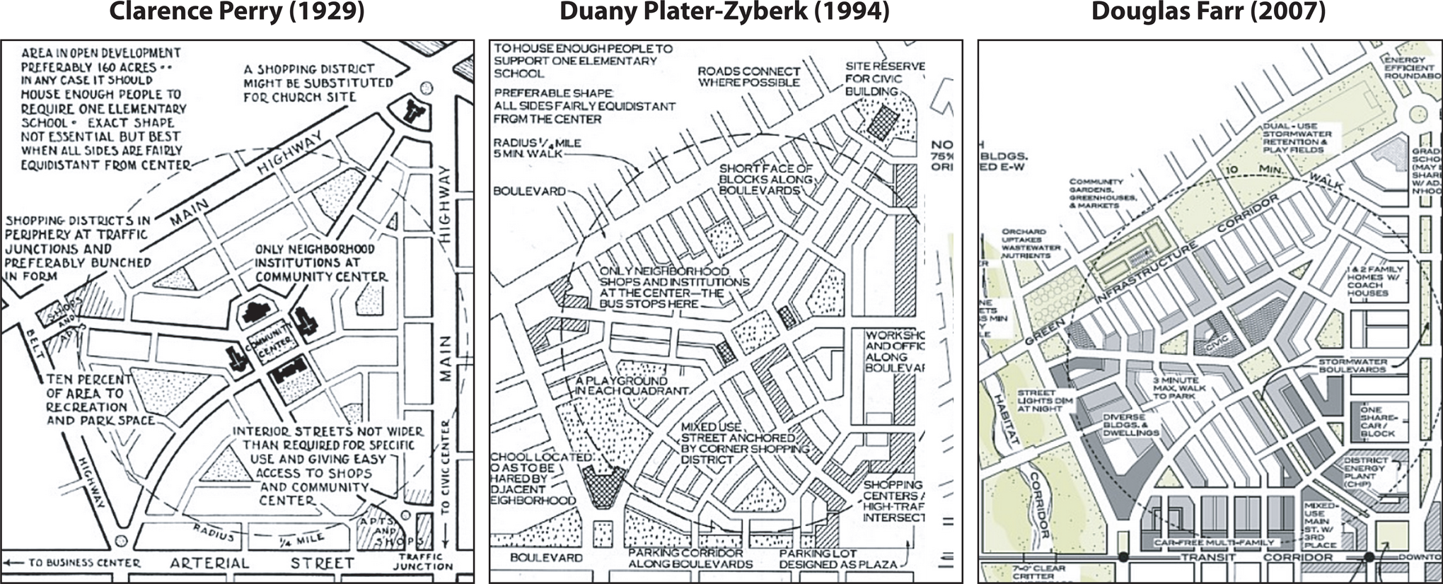
The evolution of the neighborhood unit concept (different scale).
Types of retail outlets and sufficient population that support them are another standard to determine the size of neighborhoods. Spreiregen and De Paz (2006) proposed neighborhoods with populations of 7,500–20,000 in order to have a neighborhood center with things like a pharmacy, automobile services, and a supermarket reached within six-minute driving. Assuming 30 mph, it encompasses a three-mile radius, 18,000 acres of land. Populations of 20,000–100,000 could support a community center providing junior department stores, retail stores selling soft goods (e.g., clothing, towels, and footwear) and hard goods (e.g., hardware, electronics, and appliances). Similarly, Gibbs (2011) classified four different neighborhoods that include corner stores, convenience stores, a neighborhood center, and a community center. Corner stores offer items that are necessary on a regular basis such as beverages, food, and prepared sandwiches. Approximately 800 to 1,000 households—about 2,500 people—are required to support the average corner store. Convenience stores offer goods and services geared to daily needs of nearby neighborhoods such as a pharmacy, small specialty food markets, bakeries, or dry cleaners. A convenience store needs around 2,000 households to be economic viability. It would locate within one- to one-and-half-mile radius in suburban areas, while five miles in rural areas. The anchor facility of a neighborhood center is a full-sized supermarket along with ten to fifteen smaller retailers. Residents shop at a neighborhood center once or twice a week on average. The neighborhood center needs 6,000–8,000 households within a one- to two-mile radius from residents; in rural areas, the radius extends up to twenty-five miles. A neighborhood with a corner store is similar to a residential neighborhood; a neighborhood with convenience stores are like an institutional neighborhood; and those with neighborhood centers are like institutional neighborhoods or community depending on whether or not they are in an urban area.
There were other suggestions beyond walking distance, schools, and retail outlets. Alexander, Ishikawa, and Silverstein (1977) mentioned specific design guides for various types of neighborhoods sampled from existing urban areas in United States. A face-block neighborhood has less than 500 people, not exceeding seven blocks. The assumption of 300-yard diameter yields fifteen acres in a maximum size for a face-block and minimum for a residential neighborhood. A population of 500–1,500 is suggested for a residential neighborhood to represent the interests of residents to the local government and to reach agreement on basic decisions. They also proposed 7,000 people—from 5,000 to 10,000—for a neighborhood larger than a residential neighborhood. They insisted that a community of 7,000 is appropriate to allow individuals an effective voice for planning such as “land use, housing, maintenance, streets, parks, policies, schooling, welfare, and neighborhood services” (Alexander, Ishikawa, and Silverstein 1977, 74). Jacobs (1961), however, criticized the planning theory that stated the ideal size of a neighborhood as 7,000 people. She noticed that the Neighborhood Unit theory was not applicable to urban neighborhoods in a big city since people in modern cities are mobile. She proposed 100,000 people to represent residents’ political voices against the authority.
From planning guidelines
The first officially recorded form of planning guides about how big a neighborhood would be appeared in the Land Ordinance of 1785 in United States, a square six miles on a side, 23,040 acres, was called a township containing thirty-six sections, each of which has 640 acres of land (Higgins 1887). One section, one-mile on a side, was also divided into four-quarter sections, a half-mile on a side. Five sections in a township were reserved for public uses and section 16, the central spot, was set for public schools. One-, a half-, or a quarter-mile radius and a centrally located school may have influence on several existing planning theory.
In early neighborhood projects, the lasting impacts of Neighborhood Unit theory were observed. John Nolen, a land use planner who did much of his work in Florida, proposed guidelines for the City of West Palm Beach in 1923 (Stephenson 2002). He suggested 450 dwelling units (i.e., 450 dwellings of 4 people on average in 1920 is about 1,800 people) within a five-minute walking radius from the city center that has an educational or cultural community center, parks, commercial areas, or offices. He argued that 1,800 people were sufficiently large to provide a unified political voice (Eades 1997; Treasure Coast Regional Planning Council 2009). John Nolen’s proposed neighborhood was of similar size to Perry’s but with lower density: 1,800 people versus 5,000 people. In as much as Clarence Perry served on the Committee on the Regional Plan of New York and its Environs in 1929, New York planning authorities accepted 7,500–10,000 as the normal population of a neighborhood, which is larger than his original suggested size of 5,000 (Spreiregen and De Paz 2006). As a solution for problems of unplanned expansion of suburbs after World War II, about 150 large master planned communities, “New Towns,” were developed (Forsyth 2002). The projected population ranged from 10,000 to 500,000 with enough land area for large open and public spaces, employment areas, various housing types, and mixed use and income groups. Conceptually, a new town comprises several villages and a village consists of several neighborhoods. There are no universal cutoff points where neighborhoods become a village, villages a town, and towns a city across New Towns. In general, a “neighborhood” ranges up to 3,000 people with open space. A “village” has 9,000 to about 15,000 people (three to five neighborhoods) including the village center with thirty shops such as appliance shops, clothing stores, drugstores, supermarkets, and the like. A “town” has from 45,000 to 75,000 people (three to five villages; Campbell 1976).
One of the best-known examples in Columbia, Maryland, opened in 1967 has ten self-contained villages, which incorporate thirty-three neighborhoods consisting of several housing clusters (Figure 4). Facilities especially for mothers and young children were placed in the center of the neighborhood: a K–5 elementary school, a day care, small stores, a swimming pool, or playgrounds. A village consists of two or three neighborhoods on about 640–1,500 acres of land (assuming one-and-a-half mile on a side) with a population ranging from 10,000 to 15,000. A village is a physical community with shared function and identity for residents, services and facilities such as middle or high schools, shopping centers, and recreational facilities across the village. A town has a town center to serve 250,000 people with around 25,000 acres of land (Hoppenfeld 1967). A town herein is more like a city or a subdistrict of a city, which could sustain itself with a business district, college site, and shopping facilities in the town center.
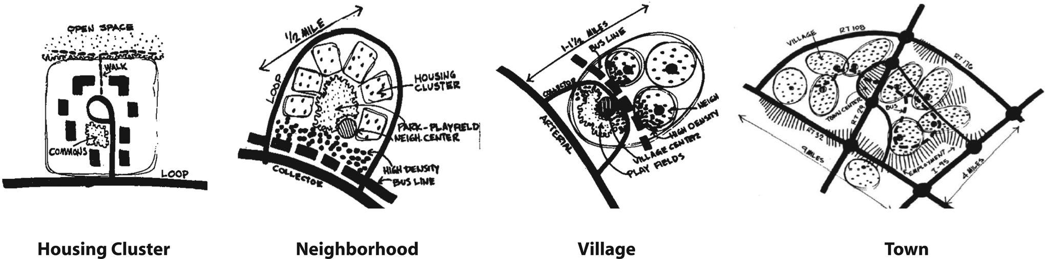
The elements of a New Town: aggregating to form the next larger unit (left to right).
The most current approaches present a similar configuration. The ideal Urban Village is similar to the size of neighborhood of new towns and neighborhood unit theory: a population of between 3,000 and 5,000 having schools, a focal village square, and some retail outlets within walking distance (Urban Villages Forum et al. 1997). The population of existing Urban Villages vary from 160 to 5,000 (Biddulph, Franklin, and Tait 2002).
Professional organizations or education institutions detailed a hierarchy of neighborhoods. The Urban Land Institute presented a plan for the City of Port St. Lucie with an order of neighborhoods, villages, and communities. A neighborhood called for 1,500 to 2,000 residents, a small park (5–8 acres), a commercial district, and an elementary school (Urban Land Institute 2004). A village is composed of three to five neighborhoods (or 4,500–10,000 people) and a community of at least two villages (or a minimum of 9,000 people). These criteria were also adopted in the 2010 comprehensive plan, and allow the size of a residential neighborhood to vary from 10 to 600 acres (The City of Port St. Lucie 2012). The American Planning Association (2006) defines three types of neighborhoods: face-blocks, residential neighborhoods, and institutional neighborhoods. A face-block refers to a group of houses along both sides of a street. If we take the ideal block size of 300 feet by 300 feet from the work of Montgomery (1998) and Alexander, Ishikawa, and Silverstein (1977), the size of a face-block is more than two acres. The size of a face-block would be larger in a place with cul-de-sac street patterns. A residential neighborhood requires at least six acres of land, which consists of more than three face-block groups. US Green Building Council developed Leadership in Energy & Environmental Design (LEED) for Neighborhood Development, which is a national rating system for neighborhood design. LEED rating system defines a neighborhood a place that has at least two buildings and up to 320 acres of land. LEED assumes transit facilities, civic and public space, mixed use, compact development, and street patterns are possible factors of interest (US Green Building Council 2006). According to the report from Texas Chapter of American Planning Association (APA) in 2010, the size of a neighborhood planning area was determined by planning resources, the community’s traditional understanding of a neighborhood area, and time (Barrett 2008). Thus, the adopted size of neighborhoods varies by cities: 5,000 people or 30 square blocks in Austin, Texas and 50–60 square blocks for Portland, Oregon. Such neighborhoods require both housing and employment, so that similar to an institutional neighborhood.
Neighborhood-based initiatives highlight slightly different criteria depending on characteristics of each project. Chaskin (1998) found that the population of a neighborhood ranges from 1,500 to 200,000 for social services or solutions for social problems. For economic development, a neighborhood needs at least 1,000–100,000 people and 1,000–6,000 people are required for education related initiatives. Neighborhoods referred to here are definitely bigger than face-block since some level of institutional and organizational support is critical for investment, to function, and to reform various types of uses.
From empirical research
Neighborhood units are often defined in empirical research with census units, a buffer from individual parcels, and other already defined geographic units such as subdivisions, planning districts, named neighborhoods, or zip code areas. None of them exactly represents actual neighborhoods, but each of them has pros and cons as a proxy.
Census-based units are frequently used surrogates because of the ease of usage, a large amount of data, and a clear boundary (Van Zandt and Rohe 2006; Coulton et al. 2001; Sampson, Morenoff, and Gannon-Rowley 2002). Census geography can also be easily aggregated to other administrative boundaries and data. Thanks to these benefits, previous studies repeatedly employed different types of census units such as tracts, block groups, and blocks (Goodman 1977; Song and Knaap 2004b; Mullan, Phillips, and Kinman 2004; Yang 2008; Hipp 2010; Patterson 2004). Census units are delineated by relatively homogeneous demography and spatial contiguity (US Bureau of the Census 1994; Clapp and Wang 2006). A block is the smallest geographic unit, and blocks are grouped into a block group. A block usually corresponds to a city block in urban areas, so that the population varies according to the condition of areas. A census block group is normally composed of five to ten city blocks with a population between 600 and 3,000: an average of 1,500 (Coulton et al. 2001; Iceland and Steinmetz 2003). A census tract contains one or more block groups. One census tract has an average population of about 4,000 in urban areas: typically between 1,500 and 8,000 people. Previous literature rarely revealed why the specific census units were chosen for the study, but researchers intuitively knew that different aspects are important in different scales of census units. Patterson (2004) measured architectural attributes and street patterns on census blocks to investigate walking, driving, and quality of life and neighborhood satisfaction. Block groups are repeatedly employed to measure social ties and cohesion, socioeconomic homogeneity, residential density, walkability, street design, retail mix, and so on (Goodman 1977; Freeman 2001; Song and Knaap 2003, 2004b; Matthews and Turnbull 2007; Coulton, Cook, and Irwin 2004). Census tracts are often adopted to study the impacts of the composition of socioeconomic status, urban form (e.g., buildings, housing mix, land use, open space, and density), and neighborhood wide issues (e.g., crime, trust, and activism). The larger the sizes of census units, the more collective features of neighborhoods are measured. Based on measures used at each census geography, census blocks are similar to face-block neighborhoods. Census block groups seem to correspond to face-blocks or residential neighborhoods. In terms of population, census tracts are analogous to residential neighborhoods. Census tracts could be an institutional neighborhood with the wider variety of land uses and heterogeneity. Without any information of specific size of census tracts, it is hard to determine whether they are residential or institutional. Some studies failed to match measures and the level of census units. For example, census block groups are not large enough to have the variety of mixed land uses with residential, commercial, industrial, and civic uses. Measuring mixed land use at this level is inappropriate. This mismatch is likely to result in invalid results.
Neighborhoods have also been defined by creating a buffer of distance around individual parcels. The buffer approach emphasizes a personal familiarity, access, or limit to the surrounding environment. This approach assumes that proximity directly relates to the perceptions of residents about neighborhoods (Kweon et al. 2010). Most of studies used a simple radius of buffer, while some studies compared the different effects of different sizes. The work of Geoghegan, Wainger, and Bockstael (1997) divided neighborhoods into “immediate neighborhoods” and “neighborhoods.” An immediate neighborhood is an area with 0.1 km (about 0.06 mile) radius buffer from a property. A neighborhood is defined by 1.0 km (0.06 mile) radius. Lee et al. (2008) defined a 0.15-mile buffer neighborhood as a “micro neighborhood,” one with a 0.3-mile buffer as an “intermediate neighborhood,” and with a 0.6-mile buffer as a “macro neighborhood.” Forsyth et al. (2007) used one-eighth-, a quarter-, a half-mile, and one-mile buffer, even though they did not name the resulting neighborhoods. Their classification gives some hint that a neighborhood could range from 0.05- to one-mile radius. Smaller buffers (i.e., less than 0.25-mile radius) are often used to measure landscape patterns and vegetation right next to the property (Geoghegan, Wainger, and Bockstael 1997; Forsyth et al. 2007). These neighborhoods are equivalent to face-blocks, as it only can cover a few blocks. Slightly larger areas (i.e., a quarter- to a half-mile radius) adopt five- to ten-minute walking distance, which is common distance for a unidirectional walk to a specific destination. The area covers 150 to 500 acres, but it could be smaller when taking a network distance—the actual travel distance determined by the level of connectivity of throughfares—instead of a Euclidian distance (Patterson 2004; Forsyth et al. 2007; Lee et al. 2008). Neighborhoods created by buffers of more than one mile could cover an area beyond the residents’ daily reach (Lee and Moudon 2006b, 2006a; Lovasi et al. 2008; French et al. 2013; Forsyth et al. 2007; Geoghegan, Wainger, and Bockstael 1997). “Buffer neighborhoods” work well for perception of environment and walkability studies, but not particularly useful as a general definition of neighborhood. Proximity alone is not a sufficient condition to correspond to aggregated socioeconomic composition, networks of residents, and central facilities in neighborhoods.
Other researchers seek neighborhoods that closely resemble to actual neighborhoods. To ease the problem of varying sizes of census units, grouped census units were often employed (Sampson, Raudenbush, and Earls 1997; Mullan, Phillips, and Kinman 2004; Weiss et al. 2007). Service areas of critical facilities, residents’ cognitive map, sociodemographic homogeneity, or geographical connectivity have been used as a basis to cluster several census units. Mullan, Phillips, and Kinman (2004) clustered seven to eleven census tracts based on service area of hospital. Sampson, Raudenbush, and Earls (1997) combined census tracts and created a “neighborhood cluster” with 8,000 people. Weiss et al. (2007) merged census block groups matched with existing neighborhood boundaries defining neighborhoods in one to eight block groups. Soft boundaries such as zip code and Traffic Analysis Zones (TAZ) are also used. Lovasi et al. (2008) used zip codes to observe socioeconomic status. The average population per zip code is about 30,000 in the United States (Krieger et al. 2002). Song and Knaap (2004a) used TAZ—the size of which varies by cities—but are often recommended to have a population between 1,200 and 3,000 (Florida Department of Transportation Systems Planning 2007).
Subdivisions and planned communities provide another alternative since they conform closely to the definition of neighborhoods. They are geographically bounded with some level of homogeneity in terms of a name, similar age of development, pattern of urban form, and residents’ income level (Blake and Arreola 1996). In addition, neighborhoods are often developed under shared covenants, building codes and codes of conduct, homeowner association bylaws, and such. Shin, Saginor, and Van Zandt (2011) noted that a subdivision is the right unit to observe developer’s unique design values. They chose subdivisions with more than eight housing units. Zehner (1971) believed the size of the group of up to eight subdivisions supports recreational facilities and a unified community-wide master plan. Rogers and Sukolratanametee (2009) examined communities with more than 100 households to observe the relationships between design patterns and sense of community.
Named neighborhoods or planning districts were also considered as neighborhoods since they have official, historical, and perceptional boundaries (White 1990; Coulton, Cook, and Irwin 2004; Sampson, Raudenbush, and Earls 1997). These neighborhoods were established through various processes and institutions. White (1990) used planning districts defined by the city of Norfolk, Virginia, which of each has a minimum of fifty households. Sampson, Raudenbush, and Earls (1997) used the community boundary defined by Chicago, which has 40,000 people. Coulton, Cook, and Irwin (2004) used named neighborhoods in West side of Denver that ranges from 1,500 to 40,000. The boundary is created based on residents’ perception.
Homeowner’s association could be another option. Chapman and Lombard (2006) chose neighborhood associations such as fee-based homeowners, property owners, or community associations. In this case, legal agreements between residents are particularly relevant. Their political and semilegal voice confirms barriers of neighborhoods, but does not always corresponds to physical boundaries. In a simpler way, a grid cell could be used to identify a neighborhood. Li and Brown (1980) used one hectare grid for symbolizing a micro-neighborhood. This gives a sense of the size of a small neighborhood, but does not satisfy the meaning of neighborhood at all.
Neighborhood Boundary
A boundary is one of the critical conditions that define neighborhoods. A neighborhood boundary is a border to protect encroachment from outside, to unite residents residing in, and to create places for transactions with surrounding functions (Alexander, Ishikawa, and Silverstein 1977). Natural boundaries, (e.g., wilderness, farmland, water, habitat corridor, retention ponds, and green ways) and man-made barriers (e.g., formed by railroads, major roads/thoroughfares, parks, and institutions covering multiple blocks) are frequently mentioned. Among the rare discussions on boundaries, Alexander, Ishikawa, and Silverstein (1977) argued that locating different land uses such as a corner grocery, or street café at the edge of the neighborhood could create a distinguishable boundary, as it is a recognizable edge between neighborhoods. The residents’ perception rarely extends beyond such physical obstacles, which limit contacts between physical boundaries (Weiss et al. 2007; Alexander, Ishikawa, and Silverstein 1977; Perry 1929; Rogers 2001). The social unity, on the other hand, encourages building physical barriers (Keller 1968). In a residential neighborhood, a more distinct boundary such as fences or gates to restrict from random access is often found. The boundaries of institutional neighborhoods and communities are relatively modest.
The types of boundaries introduced in empirical research are not very different from theories and planning guides. Empirical research often relies on neighborhood units that have officially clear boundaries: census units, planned neighborhoods, planning districts, zip codes, or subdivisions. They are often designated by visible features such as roads, streams, and railroad tracks, but sometimes follows nonvisible features such as property lines or historically recognized governmental boundaries such as city, township, school district, county, or short line of sight extensions of roads. Boundaries of planned units such as subdivisions, planned communities, and fee-based communities have officially documented boundaries that are usually recognized by residents who, especially if they own the property, know exactly what unit they belong to. The boundaries often coincide with geographical or physical features, but not always.
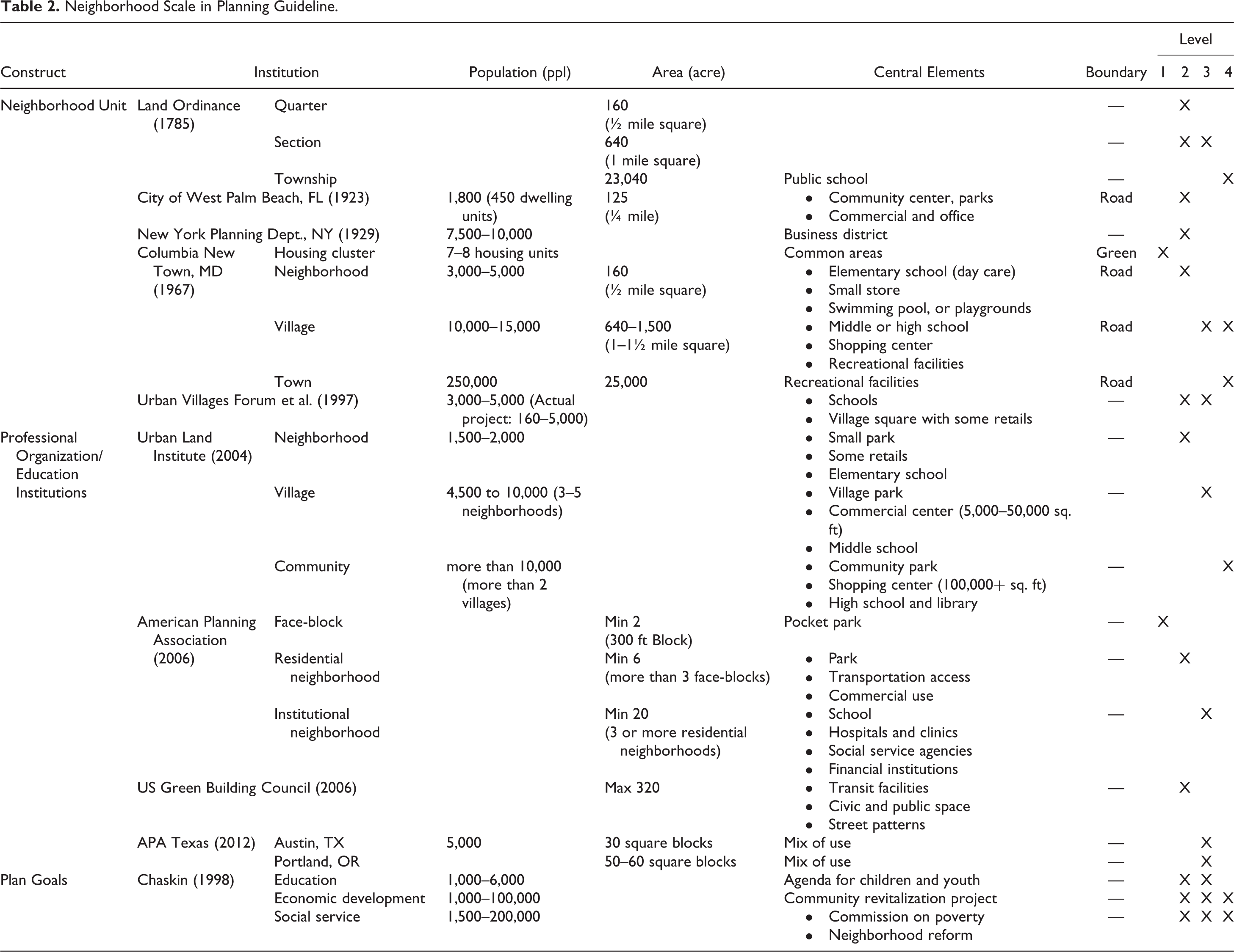
The boundaries of buffer neighborhoods are not concrete. Neighborhood boundaries created by a Euclidean distance buffer seems to be a less plausible definition of neighborhood than “geographically defined” places. They are just insubstantial circle on a map. Buffers created by a network distance use the property line at the border of a defined distance. It is also not enough to be called a neighborhood boundary, but rather is a limit of physical or perceived access (Tables 1, 2, and 3).
Neighborhood Scale in Planning Theory.
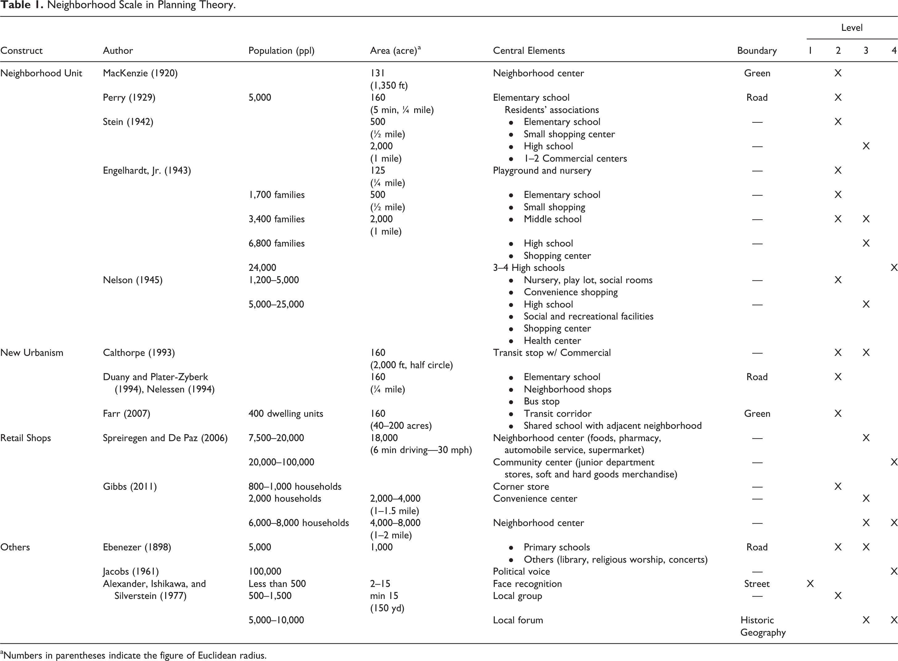
aNumbers in parentheses indicate the figure of Euclidean radius.
Neighborhood Scale in Planning Guideline.
Neighborhood Scale in Empirical Research.

Note: CBD = Central Business District; QOL = Quality of Life.
Conceptual Frame Guiding Neighborhood Selection
The selection of a specific neighborhood definition that could capture the essence of the meaning most relevant to the problem is the first step in practice and research projects. Existing planning theory and guidelines offer definitions that are quite sensitive to the goals of planning and research. Definitions in theory are driven by the values of the planner and mostly toward physical design. Empirical research, on the other hand, operationalizes neighborhoods to maximize data availability and measurement and to increase the likelihood of achieving meaningful outcomes. Even though there are no uniform criteria for all, planning theories, guides, and empirical research provide some insights into how to select different level of neighborhoods. Four possible levels of neighborhoods are recommended. They are determined by physical elements such as population, area, central elements, boundaries, and socioeconomic homogeneity/heterogeneity.
Face-blocks are clusters of neighborhood houses bounded by a street segment or a square block. Because of relatively small geography, residents generally have some level of personal relationships, face-to-face interaction, or facial recognition. Face-blocks are good units for studying relatively close relationships such as social connectivity, cohesion, support, and neighboring patterns because informal social ties and agreements prevail at this level. The planning initiatives are mostly informal, perhaps some “washed-down” from property covenants, deed restrictions, building codes, or neighborhood plans. The sizes vary as face-blocks are created mostly by individual intimacy. A face-block is as small as seven to eight housing units in one block and as large as 500 people with seven blocks (i.e., about 15 acres) since it does not require space for shared facilities. Empirical research often uses a census block, less than 700-foot radius buffer, or one-hectare grid for a face-block neighborhood. The population ranges from 180 to 360 with an area of 2.5 to 40 acres.
Residential neighborhoods are the smallest units with shared identity often expressed in names. Residential neighborhoods tend to be homogeneous in terms of neighborhood designs, demography, and socioeconomic status. Street patterns, lot size, landscape patterns, ethnicity, income, or education level, might be similar. This neighborhood is big enough to place one or two small retail outlet/outlets or core facilities such as a nursery, an elementary school, or a community center. The central land use remains residential. Hence, the strongest physical or natural boundaries could be seen at this level to protect the residential environment from unwanted intrusion. Extensive land use mix in residential neighborhoods approaches the near-zero limit, if neighborhoods are not located in the urban core. A typical residential neighborhood has 500–5,000 people on as little as 15, but up to 500 acres of land in theory. Empirical research uses a minimum value of eight dwelling units of around 25–8,000 people to form a residential neighborhood on 125–500 acres.
Residential neighborhoods are seen as the minimum planning units that the private sector is mostly responsible for in residential neighborhood plan/design. They can be subject to regulation through specific planning tools. Subdivision regulation (e.g., design plan, plats, or public improvements) and a site plan approval or design review (e.g., parking, means of access, screening, signs, landscaping, architectural features, or location) often bear on the development phases. Subdivision covenants/deed restrictions (e.g., design review for residential, landscaping, or deposition of trash and storage) and limited special ordinances (e.g., tree, facade, or noise) for managing the condition of neighborhoods often regulate ongoing conditions. Political governing authority, in the form of homeowners’ or property owners’ association, appears at the residential neighborhood level.
Institutional neighborhoods are the largest neighborhood that can be called “neighborhoods” with demarcated boundaries in a geographic space. The boundaries of institutional neighborhoods are recognizable, but more modest than residential neighborhoods. Institutional neighborhoods contain several residential neighborhoods along with other types of land uses. Health centers, recreational and social facilities, or shopping centers are often placed across the area, which are available to residents, workers, and visitors. Observing micro-scale design elements regarding architectural characteristics, street patterns for pedestrian circulation, or landscape patterning is not appropriate at this level. These neighborhoods are the starting point where the public planning sector can get involved with land use, transportation, economic development, open spaces, social services, commercial revitalization, residential needs, or environmental issues. Theory and planning advocates 5,000–10,000 people with approximately 1,000 acres of land. Empirical research adopts a similar specification of 1,000–8,000 people on 650–2,000 acres of land. The population of institutional neighborhoods largely overlays that of residential neighborhoods in empirical research, which means it is likely that confusion could lead to some mismatches between measures and the most appropriate neighborhood unit.
The community of the past was likely to be one type of a naturally formed neighborhood. The early immigrant workers with the same ethnicity clustered like an old clan-based village in United States (Chaskin 1997). They created culturally distinctive areas and provided more sense of solidarity. In many US cities, China towns are unique examples of the ethnic enclaves that have remained hundreds of years. Today, the term community employs a wider meaning. It is more attributed with circumstantial (socioeconomic status and life cycle) and functional (shared services and goods) cohesion than social (a network of relationships) and cultural (religion or ethnicity) unity. Thus, modern local communities are more likely to be the largest neighborhoods including several subsets of neighborhoods, a group of townships, or a portion of a city with the loosest identity (Sampson, Morenoff, and Gannon-Rowley 2002). The community usually provides services such as police, fire protection, or infrastructure that clearly spills over into the lower levels of neighborhoods, but are led and operated by the community or city as a whole. Community planning or city planning also takes place at this level. Land use, housing, transportation, community facilities, critical or sensitive area plans, or natural hazards are the major concerns at this level. Special planning tools for specific purposes or areas such as development impact fees, tax-increment financing districts, business improvement districts, empowerment zones could also be implemented. The proposed threshold population ranges from 24,000 to 200,000, but the size of a community could be much larger.
Conclusion and Discussion
This review highlights two aspects of neighborhoods through a review of planning theory, guideline, and empirical research—a neighborhood hierarchy and characteristics with respect to population, areas, core facilities, and boundary in each level of neighborhood. Findings and discussions distilled from pervious literature are (1) the nature of multilevel structure of neighborhoods and conditions that characterize each level of neighborhood, (2) a proper selection of neighborhood that fits goals and issues, (3) the consideration of neighborhood size and boundary in neighborhood-based planning and research, and (4) a question about using the same parameters from Neighborhood Unit theory.
First, a neighborhood is a complex set of interwoven functions and relationships, which provides the richness that has come to be known as neighborhoods. These subtle connections are bound to a place and to people therein and subtly distinguishable form. Identifying different scales of neighborhoods, however, is necessary for design, planning, and research activity. This study suggests four possible subsets of neighborhoods: face-blocks, residential neighborhoods, institutional neighborhoods, and communities. The definition of each neighborhood becomes clearer when taking into account specific physical conditions such as population, area, core facilities, and boundaries. The suggested conceptual frame helps guide the choice of an appropriate neighborhood unit to enhance planning and research projects.
Second, planning theory and design guidelines effectively characterize each neighborhood in terms of problems, elements therein, and the implementation. The choice of the neighborhood in empirical research, however, typically follows either previous research or practical reasons that optimize available data and minimize conceptual contamination. If the adopted operational definition comes from the problem to be addressed, free selection of neighborhoods is unlikely to be of great concern. For example, a buffer neighborhood used in walking-related studies is appropriate, although it does not fully embrace a complete concept of a neighborhood. If that is not the case, the size of neighborhood matters. If the unit is too big, the aggregation of physical and social characteristics will matter. In contrast, the disaggregation is a problem when the unit of analysis is too small. Hence, linking the levels of neighborhoods associated with the problem being addressed and potential outcomes/solutions improves the likelihood of success. Care in choosing the level of neighborhood with respect to the nature of goals and issues is critical in future neighborhood studies and practice.
Third, neighborhoods cannot be defined solely in terms of place or people. Neighborhoods are fundamentally spatial, and thereby require more than social and behavioral characteristics. Conversely, neighborhoods require more than mere geographical boundaries, they involve fundamentally functional needs of the people therein. To be complete the definition of neighborhoods, both the place (including boundaries, urban form, landscape ecology, and geography) and the people that populate the place (including density, income, education, ethnic character, and culture) have to be considered. Theory and design guides attempt to explain both place and people. Empirical research describes relatively well the characteristics of people who live in neighborhoods, but not the physical condition of units used. Explanations, just only a descriptive table, about the size of the population, area, and boundary need to be included as well to give some sense about the “place” of neighborhoods used in the study.
Finally, the value adopted in planning guides, empirical research, and planning theory are still driven by Neighborhood Unit theory, which can be traced back to the settlement of New England and the Land Ordinance of 1785. The suggested rule of thumb—a quarter- to a half-mile of radius or one side of a square, about 5,000 people to form a residential neighborhood, and the central location of a core facility—persists to the present. To create a viable neighborhood full of pedestrians, increased face-to-face contacts, and feeling of security, the idea based on walkable neighborhoods is worthy of embracing. It is still a questionable whether this notion is practical in different contexts and a rapidly changing world.
Limitations in the neighborhood concept persist in spite of some increased clarity on a neighborhood hierarchy and provided herein. This article recognizes that an extensive discussion of the social, cultural, ethnic, and historical aspects of the people who occupy neighborhood is essential in providing a complete characterization of the neighborhood. Additional information about those characteristics for each neighborhood level would improve the conceptualization of neighborhoods. Such a comprehensive work is likely to be useful for policy makers, practitioners, and researchers.
Footnotes
Declaration of Conflicting Interests
The author(s) declared no potential conflicts of interest with respect to the research, authorship, and/or publication of this article.
Funding
The author(s) received no financial support for the research, authorship, and/or publication of this article.