



Abstract
This article represents an attempt to establish a fruitful dialogue among the field of border studies, history education, sociocultural psychology, and the history of cartography. Seminal studies on borders have asserted that the historical maps included in textbooks are basically an imagined representation. This paper will consider the extent to which cultural and educational origins and uses of these maps, particularly in school settings, act as a support to historical essentialist views. Via the example of history education in Argentina, we carried out an empirical and theoretical examination of the processes of cultural production and consumption of historical maps and their relationship to historical master narratives. Results show that most laypeople largely think of national borders as possessing an essential and immutable character. We consider that closer study, from a sociocultural perspective, of the relationship between master narratives and historical maps may add an enriching element to the existing body of work produced by border studies.
Interdisciplinary studies on national borders
In recent years, the field of border studies has undergone extraordinary development (Barth, 1968/1998; Eder, 2006; Graziano, 2018; Kaplan & Hakli, 2001; Newman, 2006; Paasi, 1998), with interest raised further by the appearance of journals specifically devoted to this topic, including the Journal of Borderlands Studies and other related publications. Most of these works explore the ways in which boundaries and borders between nation states shape people’s day-to-day practices and influence our understanding and classification of migratory movements. Some of these debates are related to interdisciplinary dialogues among geographers, political scientists, sociologists, anthropologists, and historians (Agnew, 2008; Newman, 2006). One of the main impacts of this work was to enable an academic revisiting of the concept of borders and a greater understanding of the centrality of borders and limits to the representations that circulate in a society on topics such as space, territory, sovereignty, politics, and cultural processes (Wilson & Donnan, 2012). Recently, authors from the field of psychology have begun to turn their attention to these topics, proposing a theoretical and empirical dialogue between border studies and the contributions of sociocultural psychology (Cubero et al., 2016; Español et al., 2018; Mársico, 2016, 2018). The aim of this paper is to contribute to this incipient dialogue, on the basis of its authors’ previous theoretical (Carretero, 2011; Carretero & Bermudez, 2012) and empirical studies (Carretero & van Alphen, 2014; López et al., 2015).
In his seminal article, in the field of borders studies, Paasi (1998) concluded that territoriality and boundaries may be present in social and cultural practices in which power is virtually invisible. This is obvious in cases such as legislation, geography and history textbooks in education, atlases, songs, hymns or pledges, values, norms and rituals or naturalized images of external threats and in the meanings of these for the respective identities. (pp. 84–85)
This assertion, naming a series of cultural devices studied by a range of disciplines, points to the necessity and productivity of interdisciplinary theoretical developments and interaction in the evolution of a complex view of how borders work as symbolic tools in present-day societies. In this spirit, our intellectual inputs to this article are as follows: (a) research into history education presents reflections on the contribution of taught history to nationalist views, particularly through history textbooks (Carretero et al., 2017); (b) recent research on the history of cartography has shown that maps contribute to promoting a political image of the territory concerned (Culcasi, 2015; Herb, 2004; Monmonier, 1996); and (c) social and sociocultural psychology explore, in particular, the representations of national master narratives and their territorial components made by citizens (Wertsch, 2002). We consider all three of these fields to make substantial contributions to our understanding of the ways in which citizens and societies represent and use national borders.
Overall, our theoretical (Carretero, 2018, pp. 77–78; Carretero et al., 2018, pp. 431–434; Parellada & Castorina, 2019) and empirical work (López et al., 2015; Parellada, 2019), tends to support the working hypothesis that numerous citizens believe that political borders either do not change at all, or do change, but rarely and only under exceptional circumstances. In other words, whereas existing social research (Balibar, 2001/2004; Black, 1997; Newman, 2003) tends to consider political borders as relative entities, subject to shifts and processes of negotiation, a significant number of laypeople largely think of them as possessing an essential and immutable character. This article will consider the extent to which processes of cultural production and of the consumption of these products, particularly in school settings, act as significant sources of those essentialist views, and the ways in which these processes unfold. The distinction between the processes of “production” and “consumption,” in this context, is a classic tenet of sociocultural psychology (Wertsch, 2002). The first, “production,” relates to the generation of cultural tools; a pertinent example for our case would be the creation of history textbooks or atlases, in which national borders are key features of the maps depicted (Kamusella, 2010). By “consumption,” we refer to processes of the representation and use of these tools by school-aged students in particular and citizens in general. Among the conclusions put forward by Wertsch (1998) are (a) production and consumption processes do not necessarily generate the same final results—which implies that not everything in textbooks is necessarily in the minds of the students—and (b) both production and consumption processes are susceptible to the impact of cultural differences.
Accordingly, this paper will approach societal and individual representations and uses of national borders via the production and consumption of a key artifact of their depiction, encountered by all citizens who go through formal schooling: historical maps in textbooks, atlases, and similar media. It will also examine the intertwinement of these processes with the production and consumption of national master narratives, that is, the narratives generally regarded as foundational to a particular nation and themselves interlinked with what classical historiographical approaches term myths of origin (Smith, 1991). We will advocate for the idea that historical maps, as included in present-day textbooks, are an essential symbolic component of these narratives. To agree with Billig (1995) in his seminal Banal Nationalism, we perceive national maps as “flagged” in daily life, proceeding beyond Billig’s observation to include maps related to the past rather than only present-day geographical maps (Bednarz et al., 2006). We will note that, in a number of cases, the historical maps included in textbooks are not only confusing and partial, but also fundamentally imagined (Kamusella, 2010).
The complex relationships between borders past and present
Let us start this section of the article with a personal anecdote related to one particular well-studied case of borders analyzed by Paasi (1998). On August 28, 1991, the second author of this paper was attending an international conference held in Finland. This was during the then-USSR’s disintegration, the emergence of the Russian Federation as a new political entity, and the initiation by a number of new states of processes of secession from the USSR. Of course, everyone in attendance at the conference was greatly troubled by the overall political situation. At the conclusion of his closing speech, the rector of the host university thanked the delegates for their contribution to the event and added: “I do hope you will have a good and safe journey back to the same country you came from.” This comment raised much laughter, of course, but proved highly prescient in terms of the political changes beginning at that time to appear on the global horizon. In a matter of months, a substantial part of Europe had undergone dramatic changes, with new nation states entering or returning to the scene.
There are relatively few moments in history at which we can observe multiple borders changing—in real time, so to speak—at this speed. In the usual run of things, historical maps included in textbooks, atlases, or mass media depict historical transformations of political spaces (Kamusella, 2010; Kosonen, 2008). One instance of a historical map would be one indicating the dramatic changes to Poland’s borders between the first (1914–1918) and the second World War (1939–1945). Maps, in their representations of such changes, aid citizens in understanding historical transformations to the borders of political entities. It is for this reason that they typically appear in historical atlases and, frequently, in textbooks. As we will go on to discuss, however, the manner of their inclusion in these works means they may reflect present-day rather than past states. Further, many history textbooks and atlases fail to incorporate important changes to maps of nations experienced at various points in history (Kamusella, 2010); current work taking place in the discipline of the history of cartography is therefore of vital relevance to illuminating these issues (Branch, 2014).
History education, national master narratives, and the roots of representational practices around political borders
All present-day political borders are the results of historical processes (J. Anderson & O’Dowd, 1999). In this light, fully understanding how citizens re-present these borders requires us to take into account specific current issues of formal and informal history education and historical culture (Carretero et al., 2017). Researchers today generally agree that the history curricula of diverse countries continue to exhibit high proportions of nationalistically oriented content that fails to do justice to contemporary historiographical research on nations and their origins (Foster, 2012; Rosa & Brescó, 2017). Further, current work suggests that frameworks that emphasize the history of the nation concerned remain dominant in school history curricula. In our view, the persistence of this type of content reflects the tension between two contradictory objectives of history education (Carretero, 2011): the aim to help students achieve a critical understanding of past and present social and political realities on the basis of learning historical thinking, and the implicit and explicit aim of constructing national identities in students via fundamentally emotional experiences and representations related to the national past. Pithily put, these two objectives relate respectively to the traditional distinction between critically understanding your country’s past and “loving” your country (Nussbaum, 2002). To some extent, this distinction also emerges in the academic discipline of history, as evident in the opposition between perennialist or nationalist historiography and contemporary modernist or transnational historiography (Berger et al., 2008).
Recent historiographical approaches have cast light on the essential role of state education in the process of the social, cultural, and political construction of nations (Hobsbawm, 1997). Most education systems around the world emerged around 200 years ago; the appearance of history as a professional and academic activity and as a school subject took place not long after this, in the mid-19th century (Berger, 2012). The targeted socialization of students as subjects of their nation via the transmission of an essentially invented national past was one important objective of history education (Carretero, 2011), an aim it shared with historiography in its mission to develop national identities among national citizenries (Hobsbawm, 1997; Nakou & Barca, 2010).
This centrality of nationhood in history education—which remains apparent even in attempts to decenter it—points ahead to a key role for borders, as delineating the constituent form of a nation, and the maps that visually represent these forms. The seminal distinction of “official” versus “unofficial” histories (Ferro, 1984) initially appeared in one of the first critical comparative studies on the “use and abuse” of school history content in different countries. Applying this differentiation to the nation and the history told from its perspective, the work by Wertsch (1998, 2002) in this field has been influential in sociocultural research into history education. “Official” history refers to the canonical history of the nation state, while “unofficial” history consists in representations of the past not included in or even silenced by its “official” counterpart. This research by Wertsch and his collaborators, crucial in introducing a sociocultural point of view on history learning to the discipline, drew on historians and political scientists such as Hobsbawm (1997) and likewise on the specific consideration by B. Anderson (1983). This last author specifically considered maps, along with museums and similar artifacts, as being among the cultural tools that serve as symbolic supports to the process of constructing nations as imagined communities, even though he was probably referring to geographical maps representing the territory in a specific moment of history. We note in this context that, unsurprisingly, a national map is typically on display in every public school setting. A further salient point in this context is the assertion by a number of modern theorists of the nation state (Hobsbawm, 1997; Williams & Smith, 1983) that all societies in the world need to feel rooted in a territory that provides their populations with security and strengthens their identity; another is that the sovereignty of modern states is defined mainly by reference to territorial arguments (Smith, 1981). In this way, borders delineate the space over which the state exercises its sovereignty (Newman, 2006; Newman & Paasi, 1998). This explains the intense concern of national leaders with establishing precise borders between states, although, historically, this endeavor has traditionally proved very difficult (Herzog, 2017). From this perspective, we can regard borders as artificial constructions, created by interventions and agreements between people, which physically and symbolically delineate the space within which an imagined national community produces and reproduces itself. In other words, national territory cannot exist without borders and people’s experience of them (Español et al., 2018).
A map further serves as the visual representation of an imagined territory as the scene of a master narrative, which, as outlined above, is an essential component of both formal and informal history education in exercise of their remit to promote and build national identities. Recent studies have demonstrated the influence of such narratives on sociopolitical interaction and spatial issues: master narratives determine social spaces by allowing or disallowing particular practices within them, or, put differently, they condition agency by stating what is normative in the given social space (Bamberg, 2005; Hammack & Pilecki, 2014; Haste, 2014; McLean & Sead, 2016). For instance, a nationalist narrative might afford civic rights and freedom of mobility within a country to those born on the nation’s soil in preference to those born in other territories. Further, these narratives also determine which practices delineate and maintain national territory (Culcasi, 2015; Herb, 2004). These practices may range from mandatory schooling and informal education in public spaces, such as historical museums and sites of memory and of historical importance, to an emphasis on regional customs and traditions and the repeated commemoration of events from the national past. Collectively, these practices generate and sustain an imagined sense of territorial continuity in a supposedly unbroken historical line.
National master narratives: What, why, how—And where?
The sociocultural view of master narratives used in history education as proposed by Wertsch (2018) sets out the idea of a schematic template that provides meaning to the past and supports the process of the nation state’s construction. An example might be the narrative of liberty and progress that underlies the imagined past of the United States of America (Wertsch, 1998), providing symbolic, now retrospective support for the process of conquering the territory previously inhabited by the Indigenous peoples of America. The present authors have sought to develop and specify these concepts in both theoretical and empirical contexts (Carretero, 2017; Carretero & Bermudez, 2012; Carretero & van Alphen, 2014; López et al., 2015). In this context, Carretero and Bermudez (2012) have identified six core dimensions to master narratives as follows: (a) a homogeneous, unified historical subject; (b) an essentialist concept of the nation and of a timeless national identity; (c) a simplified, teleological, or monocausal historical plot; (d) the accordance of a heroic exemplary status to the national protagonists; (e) an implicit identification with these protagonists and their goals; and (f) a positive evaluation or at least a moral justification of these protagonists’ actions.
In what follows, we will show how historical maps and political borders, as they are represented in history textbooks, tourist guides, historical atlases, and similar cultural tools—and also in students’ minds—support and uphold these dimensions of master narratives. Our examples, drawn from research we are currently undertaking and illustrating the theoretical suppositions we have put forward, will relate to cultural processes of both production and consumption. One of our key emphases, here as in this current research, is on filling the present research lacuna surrounding the status of the representation of space as an essential feature of historical national master narratives (Carretero et al., 2018); we hypothesize that the representation of the narrative’s “where” element, for example on a map, appears to decisively underpin the narrative’s overall credibility. As we will see below, however, misrepresentation of these spatial features occurs frequently, and the participants in our research may conceive of them from an essentialist and nonhistorical point of view.
As indicated above, the first two dimensions of master narratives identified in our previous work (Carretero & Bermudez, 2012) are (a) a homogeneous unified historical subject and (b) an essentialist concept of the nation and of a timeless national identity. In this context, we observed that the majority of those interviewed for our research considered that the establishment of the historical subject takes place in terms of inclusion and exclusion, a process that radically opposes that subject, as a coherent and homogeneous group, to others (Carretero & van Alphen, 2014; López et al., 2015). In this way, the interviewees affirmed the view that a nation establishes itself on the basis of a preexistent, immutable, and everlasting historical subject which, of course, determines the main voice of the narrative. In other words, our respondents viewed the historical subject not as the cumulative result of a number of changes across different historical periods, but as something existing prior to these historical transformations. This “historical subject,” then, is in fact an “essentialist subject” based on a process of imagined continuity between the past and the present. Further, the master narratives explored by our studies exhibit an essentialist concept of the nation and of a timeless national identity, presenting each of these as entities predating the processes that led to their creation and independent of historical developments. In this vein, for example, both Spanish and Argentinian master narratives introduce the existence of Spain and Argentina respectively at a point in history long before such political entities in fact existed; the same is the case in relation to both Spaniards and Argentinians as citizens (Carretero & van Alphen, 2014; López et al., 2015).
The analysis that follows will take up one of these examples, namely Argentina; we have presented the case of Spain elsewhere (Carretero et al., 2018, pp. 431–434). Figure 1 presents a recurrent mechanism evidently at work in this context, which appears to alter the representation of historical maps. It shows the extent of overlap between historical maps of a country produced in our time and the representation of the national territory from past eras.
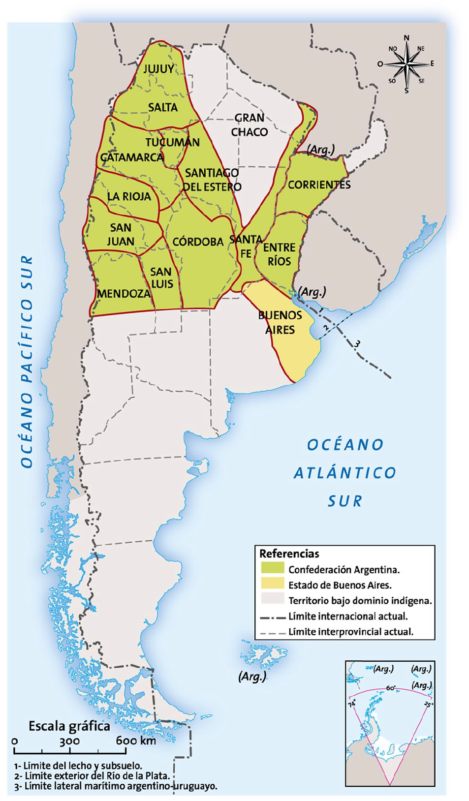
Map showing the territorial situation of the Argentinian provinces in 1823.
This overlap perpetuates two interesting discursive mechanisms of relevance to our question: the merging of past and present, and the continuity of an imagined historical subject. Figure 1 illustrates the dimensions and configuration of Argentinian territory at the beginning of the 19th century; however, the description of the space draws on the external and internal boundaries of present-day Argentina. The basis of this map, then, is the contemporary Argentinian state; a sense is evident of all these territorial temporalities merging into one, obscuring or erasing the distinction between past and present—the perception and identification of which, ironically, is one of the key historical thinking skills whose promotion is a core task of current history textbooks (Seixas & Morton, 2013). Significantly, the map’s caption does not explicitly mention this overlap, which denies students the opportunity to detect the map’s claim to be a description of both past and present at the same time. The map, then, depicts the Argentinian nation as a constant historical subject and the national territory as a taken-for-granted, continuous space that has retained its essence historically despite interventions and transformations through the ages (Lois, 2014).
We will now compare this analysis of an artifact of a cultural production process with that of a process of consumption. A study conducted by two of the present authors with middle school students of Argentine nationality explored representations of Argentina’s national territory produced when students are asked to create a historical narrative about Argentina’s independence from Spain in 1816 (Parellada & Carretero, 2016). In this context, they were also asked to draw the borders of the territory, which became independent from Spain at that time. The results show that the majority of students drew the borders of 1816 as if they were the present-day ones. Figure 2 shows a typical response to this task.
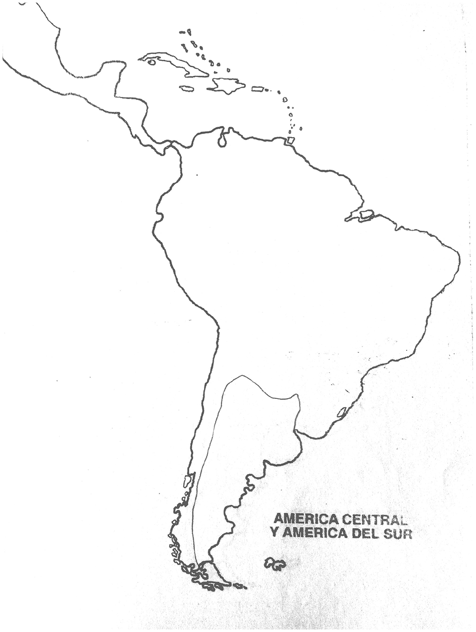
Student’s drawing of 1816 Argentinian independence.
This image reveals an essentialist representation of the territory, delineating Argentina’s current borders as if they had always existed, although the territory that became independent in 1816 and the current territory of Argentina are not the same; as Figure 3 illustrates, most of that current territory was not part of the Argentinian territory at independence, instead belonging to Indigenous inhabitants.
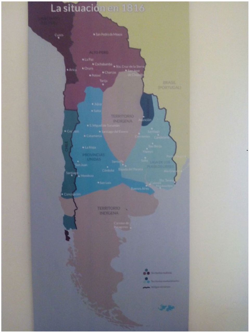
Map representing the territorial situation of South America in 1816.
It was not until the late 19th century (1878–1885) that the Argentinian state undertook the military campaign known as the “Conquest of the Desert,” taking an immense portion of the Patagonian lands from their original inhabitants (Nagy, 2013). However, the student participants in our study represented the territory as if these lands had always belonged to Argentina, and in so doing reveal an essentialist vision of the national territory, a view likewise alive and well in textbooks as described above. It is also very likely that these representations reflect the collective memory of a significant proportion of Argentinian society; cultural productions such as statues, street names, and other elements of heritage that omit Indigenous aspects of that heritage while lauding the military seizure of the previously Indigenous territories are frequently observed in Argentina (Barreiro et al., 2017).
“Since time immemorial”: The power of imagined national territories
As noted above, our research identified as a further dimension of national master narratives a reductive, teleological (Carretero & van Alphen, 2014), and monocausal historical plot that simplifies a course of historical events around one common narrative theme, such as a quest for freedom or territory. Such territory is typically depicted on a map, which also has a historical dimension, as frequently found in historical atlases and history textbooks. Alongside the monocausality of explanation as to how the territory came to be, which contrasts with the multicausal nature of sophisticated historiographical narratives, the emphasis is partial: a narrative focusing on freedom, for instance, only considers the freedom of the specific national group in question, tending to erase or minimize the right to freedom of other groups of possible subjects, such as Indigenous populations, slaves, or women. This type of narrative posits the existence of a natural territory belonging to the nation and its nationals “since time immemorial,” rather than conceiving of the correspondence of nations and their territories as the result of various complex political, social, and historical processes. In this vein, historical maps included in textbooks usually obscure the limits of the territories occupied by erased historical subjects such as Indigenous groups and slaves. A further element of this erasure is the neglect or obfuscation of exact and accurate temporal information on the establishment of national borders. Figure 4 shows a map of Argentina first produced in 1875.

Map of the Argentinian Republic Produced in 1875.
This map was in fact produced in the United Kingdom by request of the Argentinian government of the time as an exhibit in the Centennial International Exhibition of 1876 held in Philadelphia. As we see, the map includes the region of Patagonia and is almost identical to the present-day political map. However, in 1875, the entirety of Patagonia was still in Indigenous hands. We note again here that the “Conquest of the Desert” did not commence until 1878 (Bayer, 2010) and concluded in 1885. In other words, it is very clear that the 1875 map, as well as exhibiting a teleological dimension that serves as a strong visual and symbolic support to the plot of the Argentinian national master narrative, embodies in itself a political project pertaining to the nation’s contemporary present and projected future (Lois, 2014).
Having commented on this artifact’s production, we now turn to its consumption: the analysis (Parellada, 2018) of interviews with university students in relation to this document demonstrates that the majority of respondents had not realized that this map was produced prior to the “Conquest of the Desert.” When asked to compare maps originating from different eras, they failed to identify the fact that the map of 1875 includes a territory which, at that time, was not yet in the hands of the nation state. Of course, the students were informed, prior to the start of the interview or during its course, about the date of the map, and the interviewer also asked them about the date of the campaign. It appears, then, that these students genuinely adopt a representation whose properties imply that they espouse a teleological view of historical maps and the borders they depict. In other words, it is likely that they have internalized a national master narrative strongly and symbolically supported by the historical maps included in textbooks and other cultural productions.
Conclusion: Borders in mind
This article represents our contribution to the detailed analysis of the cultural processes explored in various seminal works on borders. Paasi (1998) asserts that the power of boundaries is invisible but present and active within a number of cultural practices. Our attempt to illuminate this presence and action relates to the representation of borders in history textbooks and national master narratives. But the cultural production process, as evidenced in textbooks and other artifacts, is only half the story; the other half, the process of these artifacts’ consumption, requires examination if we are to identify the workings of master narratives in citizens’ imaginings of borders and the mechanisms that uphold them against the challenge of more nuanced historical research and fact.
The intellectual input we bring to this paper stems from history education, history of cartography, and sociocultural and social psychology. We would like to conclude by reflecting on the contribution of each of these disciplines to our argument as set forth here. Our analysis of Argentinian textbooks points to the misrepresentation of this nation’s historical borders (Parellada, 2019); this gives cause for concern about the accuracy of the knowledge transmitted to Argentinian students on the state of their nation’s territory from the period subsequent to independence in 1816 and the changes it has undergone since. Indeed, our research indicates that the representation of this territory appears as static and as confounded with the country’s present-day territory. We have been able to draw similar preliminary conclusions about textbooks from other countries, such as the U.S. (Carretero, 2018), also the current site of a research lacuna (Kamusella, 2010). This finding is indicative of the nature and dimensions of national master narratives as we have analyzed above, foundational narratives that serve as the cores of national history education all over the world. Prototypes of these narratives came into being around the end of the 18th century, as school versions of national myths of origin and arising simultaneously with the discipline of history itself, in order to provide symbolic support to the imagined entities of emerging national states. It is this function of symbolic support that sees them remain important parts of history textbooks to this day. Master narratives do not precisely circumscribe the geographical locations of the territories where their constitutive events took place; instead, they elide or erase the process of territorial conquest and violent conflict with Indigenous populations and other nations, as in the “Conquest of the Desert” as detailed above. This process, in cultural production, of negating dramatic changes in national borders in favor of an impression of “time immemorial” immutability, finds reflection in the process of consumption, as our interviews with university students show (Parellada, 2018). At least in the Argentinian case, then, the process of production that generated an essentialist view of the nation’s borders appears to have been most effective, because these students appear unaware of those borders’ historical transformation in the late 19th century. The significance of these maps has been a substantial finding of research on the history of cartography (Lois, 2014); we learn, in our case, that the Argentinian state produced a map of a national territory essentially identical to the present-day one prior to the “Conquest of the Desert.”
Current Argentinian history textbooks assert that the territory of Patagonia belonged to Argentina before the “Conquest of the Desert” commenced in 1878, which is not, in fact, the case, because Patagonia became part of Argentinian territory after and through this military campaign. It is evident that, if they do not receive accurate information on how this territory changed as a result of human action, students will struggle, at the least, to understand that its present-day borders are the consequence of political and military action across history. Borders very often arise from processes of domination and oppression inflicted by one group of people upon another. Typical national master narratives deny people awareness of this, instead claiming that the construction of national territories can be explained by teleological causes such as an alleged or implied “national destiny” (Carretero, 2018). It is worth reminding ourselves here that master narratives are powerful tools, transmitted officially and enduring over time (Alridge, 2006), in the service of forging a sense of patriotism and national identity among citizens (Carretero, 2011), and that national territories tend to be one of their central elements. Collective representations of state borders come into being through these narratives and through their supporting cultural instruments, such as maps, which often appear in mass media. A map, as a cultural tool, serves to synthetize and give concrete form to the meaning transmitted in the narrative. It is our view that this relationship between master narratives and historical maps reinforces an essentialist and timeless representation of national borders.
In conclusion, we consider that closer study, from a sociocultural perspective, of the relationship between master narratives and historical maps may add an enriching element to the existing body of work produced by border studies. Wilson and Donnan (2012) rightly note that “it is difficult in today’s world to avoid public debates over borders, or to ignore the many ways in which borders figure in a great deal of popular discourse” (p. 2). We believe there is great potential for further crucial insights in considering the characteristics of such figurations in relation to nation-state borders and exploring citizens’ engagement with and response to this popular discourse. Our empirical investigations, as set out here, point to a lack of distinction between past and present in many citizens’ productions of maps referring to the limits of their national territory. We will end, however, by noting that it will be the task of future research to arrive at a more detailed theoretical and empirical conclusion on our working hypothesis around borders of historical maps as upholders of national master narratives. Areas that call for further investigation include the extent to which specific social identities and related factors, such as cultural beliefs and personal ascriptions of significance, might exert an influence on this process of citizens’ imagining the borders of their own nation as either static or dynamic—that is, as either the result of an essentialist conceptualization of the nation or a historical process.
Footnotes
Declaration of conflicting interests
The authors declared that there is no conflict of interest with respect to the research, authorship, and/or publication of this article.
Funding
The authors disclosed receipt of the following financial support for the research, authorship, and/or publication of this article: this work was supported by the projects RTI2018-096495-BI00 (MINECO FEDER, Spain) and PICT-2016-2341 (ANPCYT, Argentina) both co-ordinated by the second author. This paper is based on the PhD thesis of the first author, supervised by the second.
