



Abstract
In this paper, we summarize the Holocene environmental history of the lower Yangtze region, east China, based on the sedimentary records and microfossil diatom, pollen, fungal and charcoal data that were published in the past two decades. We then examine the linkage between changes in the coastal environment and the development of rice agriculture in the region, with reference to the available archaeological evidence and historical archives. Based on the sedimentary and archaeological evidence, we conclude that during the early Holocene sea-level movements and sedimentary processes significantly changed the region’s landscape from an open, brackish water environment to a largely enclosed, wetland system. This newly established freshwater marsh environment provided a habitat favourable to rice agriculture. The early Neolithic farmers took the opportunity presented to them and started rice cultivation in locations where freshwater wetland systems were established. During the middle Holocene, environmental conditions were largely stable, and the coastal wetlands evolved slowly. Environmental change was only a supportive player in the Neolithic cultural processes, because the Neolithic people were able to adapt to these changes and took advantages of the newly emerging marsh land for food collection and production. Around 4200 years ago, the prosperous Liangzhu society fell, but there is no evidence to suggest the fall was related to a significant environmental change. The coastal environment continued to evolve slowly during the late Holocene. But this period saw rapid technological development in irrigation and flood protection, and the environmental factor was reduced to background noise. Throughout the Holocene, the main strategy taken by the Neolithic people to cope with environmental change was migration to find better food sources. Along with this strategy was the development of technology in landscape management to ensure a more reliable food production in addition to food collection through hunting, gathering and fishing.
Introduction
Recently, the impacts of climate change upon human civilizations have been studied intensively, and some of the suggestions have led to heated debates in the wider academic community, including the claims that climate change has caused dynastic changes in China (e.g. Yancheva et al., 2007; Zhang et al., 2008). Some recent work has looked closely into the mid-Holocene climate transition and analyzed the interconnection between climate–environmental change and agricultural history from a number of regions across the world (e.g. An et al., 2004, 2005; Anderson DG et al., 2007; Lu et al., 2002; Weiss and Bradley, 2001; Weiss et al., 1993; Wu and Liu, 2004; Zhong and Xiong, 1999). Despite the strong environmental evidence revealed by these studies, some questions were raised (Catto and Catto, 2004): is climate–environmental change a driving force, supporting player, or ‘background noise’, for cultural changes? Some anthropologists (e.g. O’Sullivan, 2008) argued further that palaeoenvironmental reconstruction alone may not be able to inform us of the reasons why human communities did things the way they did, and that the answers may be found from studies of human societies that tell us about the economics of human interaction with the environment. In other words, palaeoenvironmental data may have to be interpreted alongside archaeological and archival data to provide a more holistic picture of what exactly happened during those critical time periods.
In coastal regions, such as the lower Yangtze, sea-level change is an environmental factor which is additional to the climatic factor and has caused changes in environmental conditions. The sea-level rise in the early Holocene transformed the coastal landscape (Zong et al., 2011). The stabilization of sea level in the mid Holocene made the resources of coastal areas predictable and plentiful, thus attractive to human communities (Anderson DG et al., 2007; Itzstein-Davey et al., 2007a, b; Zong et al., forthcoming). However, coastal ecosystems are sensitive to small changes in sea level, as it changes the frequency of tidal inundation and the salinity of coastal waters. Neolithic communities exploiting coastal resources may have been vulnerable to, or affected by such changes (Chen et al., 2008; Innes et al., 2009; Zong et al., 2007). It was suggested that rises in sea level during the mid Holocene may have increased the spatial extent and frequency of marine floods in the Yangtze deltaic lowland, which in turn contributed to the rise and fall of the Neolithic culture that once flourished in the Taihu area (Chen et al., 2008; Stanley and Chen, 1996; Stanley et al., 1999; Yu et al., 2000). However, this hypothesis is highly contested. Some have argued that the Neolithic community in the Taihu area was able to adapt to an increase in marine flooding by simply migrating inland to the many small hills and areas of higher ground to the west of the coastal lowlands (e.g. Wu and Liu, 2004). In fact, existing archaeological records suggest that one Neolithic group did so to the area close to the uplands around Liangzhu City (Figure 1B), yet the other migrated seawards during this period across the east Taihu area (Chen et al., 2008; Stanley and Chen, 1996). In other words, it may be human choices that had resulted in such settlement movement. Other authors indicated that there was a significant change in forest composition from dominantly tropical-subtropical oak woodland to a mixed temperate forest with a significant pine component (Chen et al., 2005). But the associated drop in temperature was so small (Yi et al., 2006) that it could not have caused a large-scale crop failure, and consequently led to cultural decline. In short, the Holocene history of human and environment in the study area has been a complex one.

Maps show (A) the east coast of China with the present vegetation zones, and (B) the Yangtze lowlands with key sites mentioned in the text: Shangshan (1), Kuahuqiao (2), Hemudu (3), Tianluoshan (4), Luojiaqiao (5), Liangzhu City (6) and Guangfulin (7)
To assess the interconnections between environmental factors and agricultural development in the lower Yangtze region, we have examined two lines of evidence, archaeological and environmental. In this paper we present our findings on (1) the relevant archaeological reports that were published in the past decades, (2) the sedimentary records available for the reconstruction of the Holocene environmental history and our newly obtained microfossil records, and (3) our assessment on the relationship between the environmental history and the rise and fall of the Neolithic societies in the study area. This paper aims to address the comparative importance of environmental and societal factors in causing cultural changes during the Holocene in the lower Yangtze region, China.
The Holocene environmental history
The monsoon climate
The study area lies on the east coast of China within the warm temperate zone of the East Asian monsoon region. At present, the region is covered by mixed broadleaved deciduous and evergreen forests, with some coniferous components (Figure 1A) (Huang et al., 2008). North of this region, in the Yellow River basin, temperate deciduous plants, such as Quercus, Betula, Alnus, Acer, Ulmus and Populus dominate the forest vegetation, with low numbers of Pinus, Picea and Abies occurring in higher altitudes. To the south, in the Pearl River basin, subtropical evergreen trees, Cyclobalanopsis and Castanopsis, are common, although some Quercus, Pinus, and Cupressaceae also occur in mountainous areas west and south of the coastal lowlands (Figure 1B). In other words, the lower Yangtze sits in the transitional area between the temperate zone to the north and the subtropical zone to the south. Therefore, climate change during the Holocene may result in a north–south shift of these zones in the form of temperature (Yi et al., 2006) and precipitation changes (e.g. Zong et al., 2006), and such a shift is expected to be recorded in sedimentary sequences of the study area.
The beginning of the Holocene saw a marked change from coniferous forest/grassland vegetation to a mixed broadleaved evergreen-deciduous forest growing on uplands of the lower Yangtze basin (Xu et al., 2010; Yi et al., 2003, 2006). By the early mid-Holocene, a mixed deciduous/evergreen forest was fully developed according to pollen records from Kuahuqiao (Figure 1B) (Innes et al., 2009; Shu et al., 2010), and it was mainly composed of Cyclobalanopsis, Castanopsis and Pinus with Quercus dominating (Figure 2a). Other warm temperate trees, such as Acer, Liquidambar and Ulmus, appeared in consistent numbers, whilst some cool temperate taxa including Betula, Corylus, Cupressaceae, Salix and Urticaceae occurred in the background. This vegetation pattern suggests a warm temperate monsoonal climate, similar to the present climate occurring over the southern part of the Yangtze basin (Huang et al., 2008). The climatic warming during the early Holocene reached its peak around c. 7500 cal. yr BP, and from this time until c. 5500 cal. yr BP, the subtropical evergreen Cyclobalanopsis dominated the forests in the study area according to a record from Pingwang, a site 10 km southeast of the Taihu Lake (Figure 1B). During this warmest period of the Holocene, the warm temperate taxa included Quercus, Castanea, Liquidambar, Pterocarya and Ulmus. The subtropical evergreen component (mainly Castanopsis and Cyclobalanopsis) accounted for around 45% of the forest (Figure 2a), some 15% more than the previous stage (Figure 2b). Furthermore, the cool temperate component in the forests (mainly Pinus and Salix) was only around 10%, which is much lower than the 20% recorded for the early Holocene. Such forests indicate a subtropical monsoon climate similar to the one presently existing within the Pearl River basin. This hypsithermal condition was widely reported from various parts of east China (Yi et al., 2003), and the mean temperature of this period in the lower Yangtze region was probably 2–3°C warmer than that of today (Yi et al., 2006).
Since c. 5500 cal. yr BP, the subtropical component (mainly Castanopsis and Cyclobalanopsis) reduced in number whilst Quercus and other warm temperate trees changed little. Most significant was the increase in cool temperate trees (including Alnus, Betula, Cupressaceae, Urticaceae and Pinus), with some Picea pollen occurring near the top of the sediment sequence (Figure 2a). This period saw the subtropical evergreen component declining from 45% to 20% whilst the cool temperate component increased from 10% to 40%, a change equivalent to a climatic zone shifting from the Pearl River basin to the lower Yellow basin (e.g. Huang et al., 2008). Such changes in forest composition are also recorded in the northern part of the Taihu region where the rise in the cool temperate component was much pronounced (e.g. Shu et al., 2007; Xu et al., 1996; Yi et al., 2003, 2006). All this evidence indicates that a rapid climate warming occurred in the study area during the early Holocene, followed by a warm middle Holocene, but in the last 5500 years a gradual and significant climate cooling was recorded in the area with temperature changing from 2–3°C warmer than present to 1–2°C cooler than today in the region (Yi et al., 2006).

Pollen diagrams from Kuahuqiao (a) and Pingwang (b) show the arboreal vegetation history of the study area for the Holocene. The AMS dates are presented as central mean dates to the nearest decade in calibrated years. Graph (a) is simplified from Innes et al. (2009)
Several short-period cooling events were reported in the Yangtze area according to the stalagmite records from Dongge Cave (Wang et al., 2005). The one that took place in 4500–4000 cal. yr BP attracted most attention. Based on pollen records from a sediment core, east of Taihu Lake, both Chen et al. (2005) and Tao et al. (2006) confirmed the occurrence of such a cooling event. However, the extent and magnitude of this cooling event, as well as its impact on vegetation, are far from clear. In fact, no biological data suggests this event was catastrophic in terms of causing a significant change to the ecosystem of the study area. Similarly, evidence of impact on vegetation in the study area for the cooling event of 8200 cal. yr BP is also limited (Figure 2a).
Relative sea-level change
The study area is situated in the transitional zone between the near-field (areas near former ice sheets) and far-field (areas far from former ice sheets) sites. The local relative sea-level history here has not been affected by glacio-isostatic or hydro-isostatic processes. In near-field sites where glacio-isostatic uplift in previously glaciated areas and subsidence in the periphery are common, resulting in a complex relative sea-level history (Long, 2001). In far-field sites, a fall in sea level during the middle–late Holocene is recorded due to hydro-isostatic processes that ocean water migrated away from equatorial regions to fill space vacated by collapsing forebulges at the periphery of previously glaciated North Polar Region (Mitrovica and Milne, 2002). Furthermore, the area has been very stable geologically, despite small subsidence occurring in the offshore area during the late Quaternary (Chen and Stanley, 1993; Chen et al., 2000). The Holocene sea-level history for the study area was reconstructed based on sea-level indicators collected from the Yangtze deltaic plain and the Taihu area (Chen and Stanley, 1998; Zong, 2004), and shows three distinctive stages of change. First, relative sea level rose rapidly during the early Holocene reaching −5 m by about 8000 cal. yr BP (Figure 3B). Second, between 8000 and 7000 cal. yr BP, the rise in relative sea level slowed down markedly, and by the end of this period, relative sea level rose to about −2.5 m. Finally, over the past 7000 years, relative sea level rose continuously at an average of c. 0.36 mm/yr towards the present. For the second period of the sea-level history, further details have been reported from Singapore (e.g. Bird et al., 2007), where data show a short period of stagnation in sea level rise from about 8000 to 7500 cal. yr BP followed by a renewed rise in sea level from 7500 to 7000 cal. yr BP.
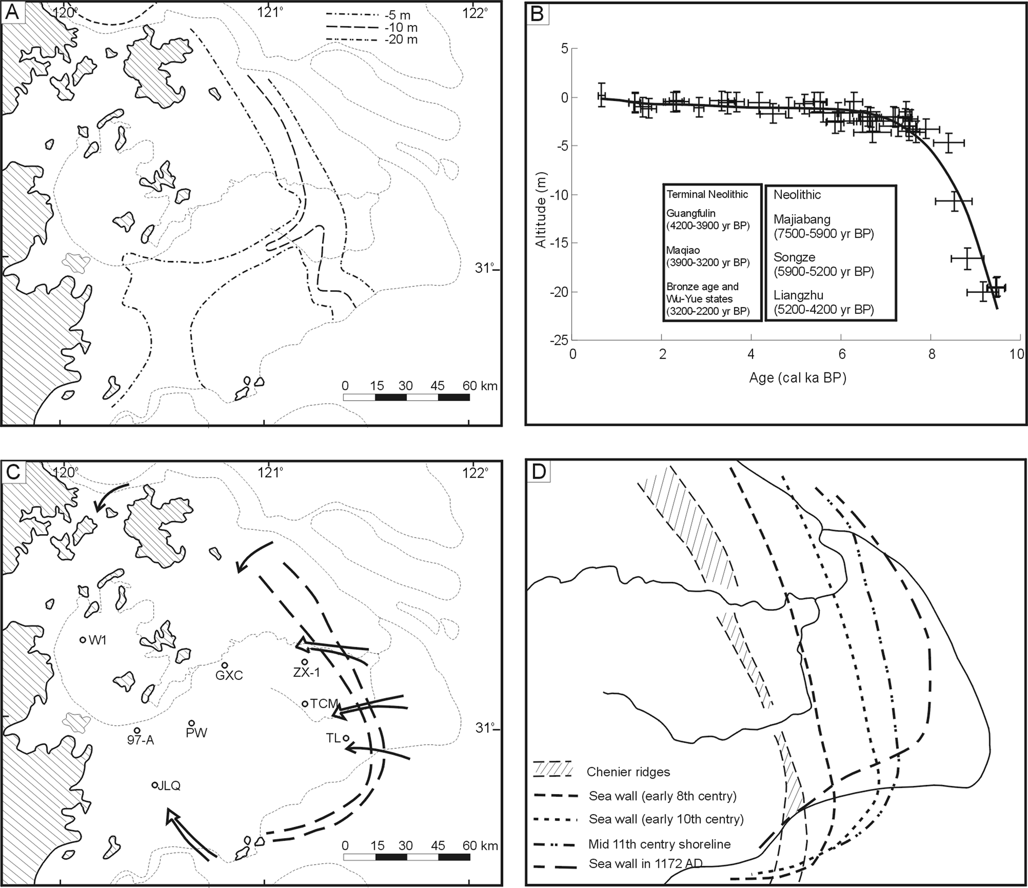
Maps show (A) the pre-Holocene landscape of the study area (after Zong et al., 2011), (B) the Holocene relative sea-level curve for the lower Yangtze region (after Zong, 2004), (C) the Chenier ridges and the mid-Holocene shoreline (after Chen et al., 1990) and locations of sediment cores mentioned in the text (W1, Chang et al., 1994; 97-A, Zheng et al., 2006; JLQ, Hong, 1989; ZX-1, Chen et al., 2005; PW, Pingwang, GXC, Guoxiangcun, TCM, Tangcunmiao, and TL, Tinglin: Zong et al., 2011), and (D) sea wall constructions and land reclamation during the past 2000 years (after Tan, 1973)
The postglacial development of the deltaic/estuarine shoreline
During the last glacial as sea level dropped to about −120 m, the Taihu area appeared as a terrace with the incised palaeo-valleys of the Yangtze and Hangzhou Bay on the north and the south, respectively (Figure 3A). As a result of the postglacial sea-level rise, these two valleys were filled with estuarine sediment during the early Holocene (Li et al., 2000; Wang et al., 2006), and the thickness of the estuarine sediment along the edge of the Taihu area is about 20 m. Around c. 7000 yr BP the Taihu area was inundated by the sea as relative sea level reached c. −2.5 m (Figure 3B), during which a thin layer of tidal flat sediment was deposited across the area (Zong et al., 2011). Shortly after 7000 cal. yr BP, as relative sea level stabilized, a series of ridges made of sandy sediment with shells (also called Chenier ridges) started to develop along the Yangtze shoreline (Zhao, 1987; Zhu et al., 1996), running southwards from the north and, off the present southern shoreline, turning west towards the head of Hangzhou Bay (Figure 3C). These ridges continued to grow over the following 5000 years, reaching a width of 2 to 8 km along the Yangtze shoreline. During the same period, the southern section of the ridges retreated gradually northwards as a response to the lateral movement of the main channel of Hangzhou Bay (Chen et al., 1990). The development of the ridges transformed the Taihu area from the open, shallow coastal area into an enclosed wetland protected against marine processes by the ridges. Muddy tidal flats emerged slowly from the area east of the ridges only in the last 2000 years (Chen and Zong, 1998), partly as a result of the shoreline progradation of the Yangtze delta (Hori et al., 2001). To reclaim these newly emerged tidal flats for agriculture and to protect the existing agricultural land from tidal inundation, people from the Tang Dynasty (the eighth century) constructed the first sea wall (Figure 3D) (Tan, 1973). Later, successive sea walls were built and more tidal flats were reclaimed from the sea.
The Holocene history of the Taihu wetland
Underneath Taihu Lake, a thin layer of tidal flat sediments was found from the lake sediment sequence (core W1, Figure 3C), containing an assemblage of foraminifera and brackish water diatoms, suggesting a phase of tidal inundation (Hong, 1991). This tidal flat sediment was laid down during a period of rapid sedimentation within the Yangtze valley and Hangzhou Bay and the emergence of the Chenier ridges (Figure 4A). This phase started in the early Holocene and continued until c. 6000 cal. yr BP when tidal influence was gradually weakened and the area covered by the present Taihu Lake became a freshwater environment (e.g. Chang et al., 1994; Qin et al., 2011; Wang et al., 2001; Xue et al., 1998). At first, freshwater marshes flourished, but later, around 4500 cal. yr BP, the area became lacustrine as the tidal inlet became blocked by sedimentation (e.g. Zheng et al., 2006). According to diatom data from sediment cores obtained around the lake (Zong et al., 2011), tidal connection to the Taihu area had been weak but persistent throughout the middle Holocene. In order words, the Taihu area was a tidal flat/lagoon connected to Hangzhou Bay during the early Holocene as a result of the development of the Chenier ridges. This area changed into a freshwater marsh environment around 6000 cal. yr BP as the connection to the sea weakened. The tidal connection to Hangzhou Bay was weakened gradually by sedimentation throughout the middle Holocene and became completely diminished by c. 2500 cal. yr BP (Zheng et al., 2006), resulting in the formation of Taihu Lake and many other lakes in the inland area (Figure 4C). The east Taihu area underwent a similar process. First, marine inundation took place across the area. In the area around Pingwang, Guoxiangcun and Tinglin (Figure 3C), a change from brackish water to freshwater conditions took place between 7000 and 6000 cal. yr BP (Figure 4A). Subsequently, freshwater marshes expanded into these locations, although weak tidal influence still existed throughout the middle Holocene (Figure 4B). Both pollen and non-pollen palynomorph results from sediment cores obtained in the inland area around Pingwang suggest the area became less well drained and lacustrine by c. 5000–3000 cal. yr BP (Figure 4C). In the area immediately behind the Chenier ridges near Shanghai (core ZX-1, Chen et al., 2005), brackish water conditions lasted until c. 3000 cal. yr BP as confirmed by the foraminiferal data from two sediment cores (Zong et al., 2011). In other words, during the middle Holocene, the inland area changed gradually from freshwater marshes to lacustrine conditions, whilst the seaward area evolved from a tidal flat/lagoon to a freshwater marsh environment.
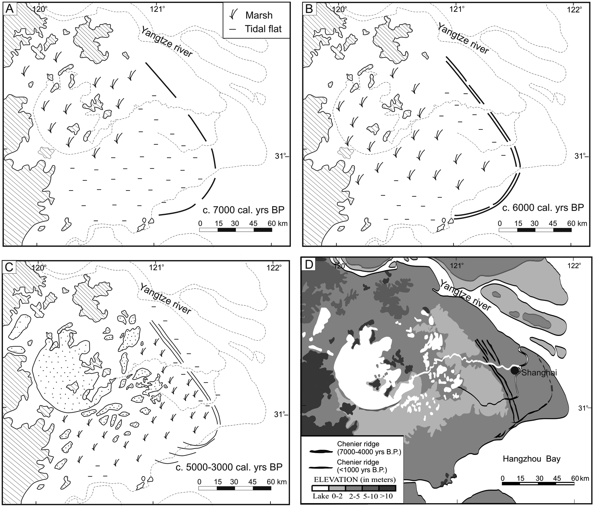
Maps show the slowly evolving environment of the Taihu area during the middle Holocene: (A) tidal flats and the development of Chenier ridges around 7000 cal. yr BP, (B) the freshwater wetland of the Taihu area around 6000 cal. yr BP as being fully enclosed by Chenier ridges with tidal inlets to the east and south, (C) lakes forming in the inland area, new marshes emerging in the seaward areas and the lagoon/tidal flats gradually diminishing between c. 5000 and 3000 cal. yr BP (the lakes are based partly on a map of
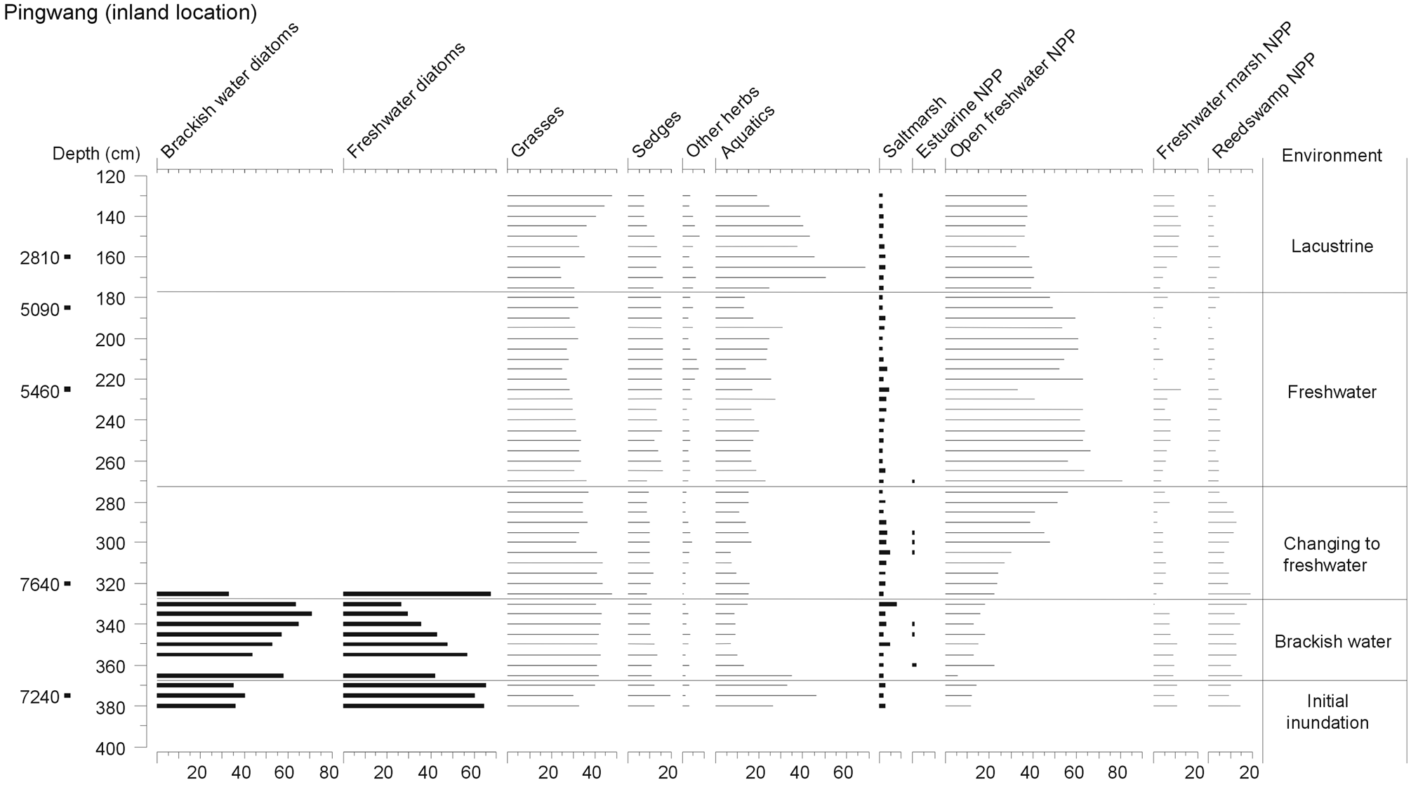
Diatoms, pollen and non-pollen palynomorphs (NPP) from Pingwang, as simplified from Zong et al. (2011) and suggests five stages of environmental change at this inland location of the Taihu area. The AMS dates are presented as central mean dates to the nearest decade in calibrated years
The cultural history during the Holocene
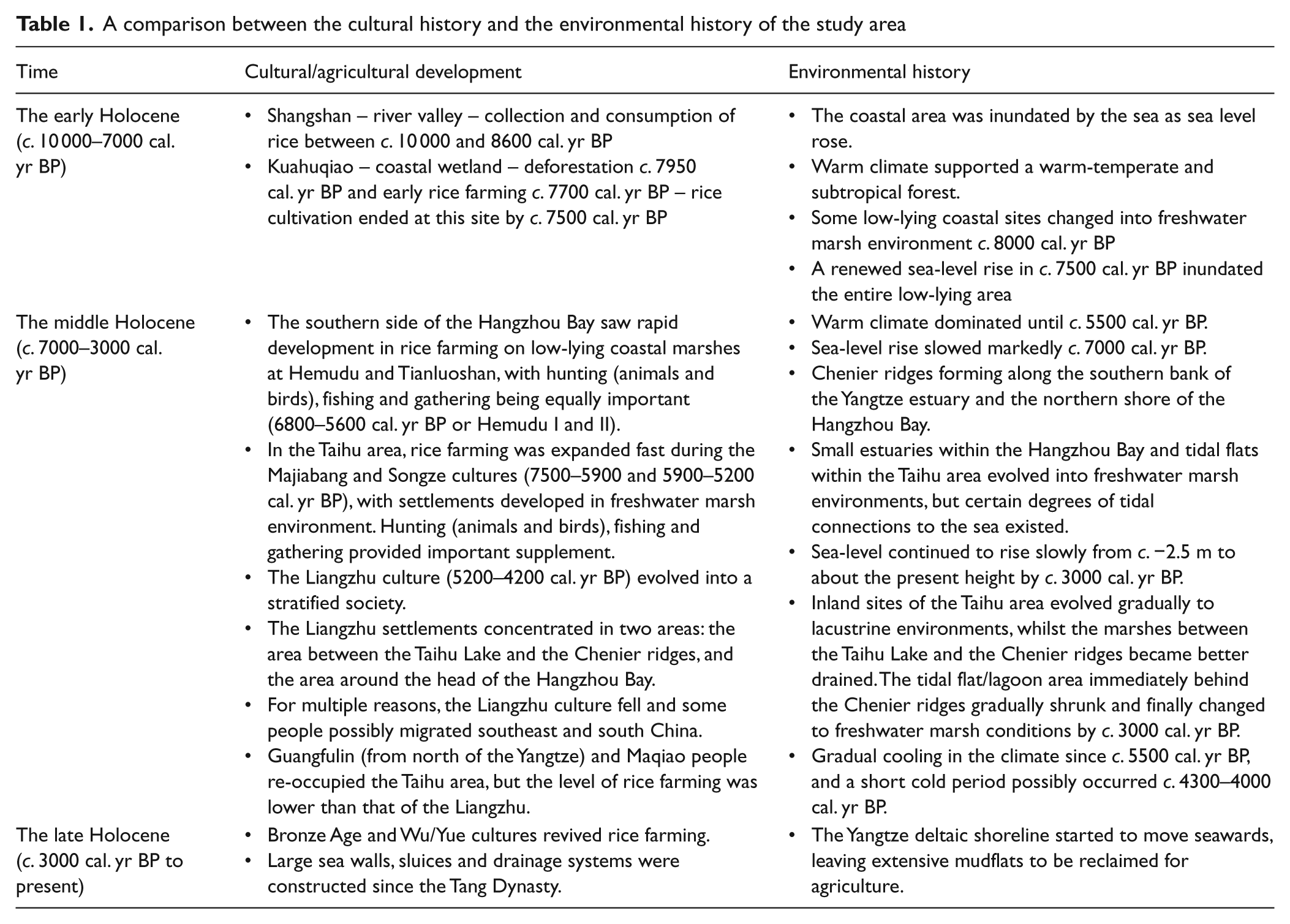
The Holocene history of cultural changes in the study area can be divided into three important stages. A broad correlation between the cultural stages and the environmental history on both sides of the Hangzhou Bay is given in Table 1.
A comparison between the cultural history and the environmental history of the study area
Stage I (10 000–7000 cal. BP)
The warming of the monsoon climate in this stage brought to the study area warm temperate to subtropical vegetation covering the hills and uplands. Fruits and nuts were plentiful, and wild animals ran over the landscape. Before and during this period, some communities lived in caves in the mountainous areas southwest of the coastal lowlands (Figure 1B) during the last glacial period (Zhu, 2006), and the warm climate invited them to move out of caves and settle on river valleys where food resources were more accessible. One such settlement is found at Shangshan (c. 60 m above sea level) (Figure 1B), from which charred rice remains are found in the fibre-tempered pottery shards (Liu et al., 2007). This site was occupied between 11 400 and 8600 cal. yr BP, from which stone balls and millstones are also found (Jiang, 2006). These stone balls and millstones indicate possible tools used to husk and mill rice and break nuts, which reflects a mode of primitive food collection and suggests rice as an important food resource (Wang et al., 2010). The Shangshan settlement is situated on a raised river terrace which is made of gravelly sands, with river channels running through both sides of the river terrace before entering into the Pujiang River. To find out if there were any wetland habitats near the Shangshan site suitable for rice cultivation, we surveyed the area and cored sediment sequences at a number of locations around the settlement site, finding no sedimentary evidence for such habitats. If Shangshan people did cultivate rice, they might have cultivated on dry land, rather than on marsh wetlands as the early farmers did at Kuahuqiao (Zong et al., 2007). Alternatively, the Shangshan community collected wild rice for consumption and used the rice husks to temper pottery they made.
Around 8300 cal. yr BP, a mixed broadleaved evergreen and deciduous forest was developed on small hills around Kuahuqiao (Figure 1B). This forest was initially opened by early Neolithic hunters and foragers by means of fire at c. 7950 cal. yr BP (Shu et al., 2010), as well as cutting trees to make dugout canoes (Jiang and Liu, 2005; Zhejiang Institute of Archaeology (ZIA), 2004) for travelling through the lake-marsh environment formed during the early Holocene at Kuahuqiao (Zong et al., 2007). After settling at the site, this community started rice cultivation at c. 7700 cal. yr BP as there are clear signs of early farming including large Poaceae pollen grains and rice phytolith found in the sediment sequences (Innes et al., 2009; Shu et al., 2010). Before the community abandoned their settlement as a result of marine flooding that overwhelmed the site by c. 7500 cal. yr BP, the Kuahuqiao people managed the wetland to keep saline water out and maintain the wetland productivity (Zong et al., 2007). Based on the similarity of the pottery found in the top layer of the Shangshan site and those discovered at Kuahuqiao (Jiang, 2006), a link was established between the two sites, and it is likely that the Shangshan community migrated downstream to the coastal wetlands around Kuahuqiao by c. 8000 cal. yr BP.
Whether or not rice domestication had started in this early stage at Shangshan and/or Kuahuqiao has been seriously debated (e.g. Fuller and Qin, 2008; Fuller et al., 2007, 2008; Jiang and Liu, 2006; Liu, 2008; Liu et al., 2007; Pan, 2008). These debates are based mostly on the morphology of the rice phytolith and spikelet bases. Thus, the environmental history of these locations provides additional, important information for the debates. First, the marsh environment which formed at Kuahuqiao from c. 8500 cal. yr BP (Zong et al., 2007) created an annually changing habitat at the edge of the wetland as water levels varied annually under the monsoonal seasons, which in turn helped the perennial wild rice to be selected to become an annual plant (Crawford and Shen, 1998). As a result, when the Kuahuqiao people arrived at the site, both the habitat and the annual form of wild rice were ready for the community to exploit. Second, Sato (1996) indicated that the original rice found in the Yangtze region was a tropical type. The vegetation data from the study area (Figure 2) confirm that the Kuahuqiao site was under a warm temperate to subtropical climate during the early Holocene. Thus it is possible that rice domestication started as early as 7700 cal. yr BP at Kuahuqiao.
Stage II (7000–3000 cal. BP)
After Kuahuqiao, Neolithic rice farming emerged on both sides of Hangzhou Bay, such as at Majiabang (7500–5900 cal. yr BP) and Hemudu (6800–5600 cal. yr BP) (Figure 1B). There is a certain degree of similarity between the potteries found at Kuahuqiao (e.g. ZIA, 2004) and those from the Majiabang site (e.g. Shaoxing Cultural Bureau, 2004), which suggests a cultural extension from Kuahuqiao to Majiabang (Jiang, 2006). Based on pottery evidence, cultural connections between Kuahuqiao and Hemudu are weak. One possibility is that Hemudu people came from a different source, one that possibly retreated from the continental shelf as sea level rose during the early Holocene. After further comparison of the potteries, it is suggested that Hemudu people spread onto the Puyang river catchment by about 6500 cal. yr BP according to evidence from Loujiaqiao (Figure 1B) (Jiang, 2006), whilst the Kuahuqiao culture moved onto the Taihu area.
Within a narrow, elongated valley of Yaojiang, Neolithic communities were settled at Hemudu and Tianluoshan (Figure 1B), a plain surrounded by small hills (ZIA, 2003). This valley was inundated by the sea during the early Holocene. When the Neolithic community arrived at Hemudu around 7000 cal. yr BP, the area was still partially connected to the sea. Subsequently, the area changed to a freshwater marsh environment, and the community stayed at the site between 6800 and 5600 cal. yr BP (Table 1) before they abandoned the site due to the increasing lacustrine conditions (ZIA, 2003). To adapt to the environment, the community placed wood piles into the ground and made their dwelling on top of the piles, a house elevated from the wet ground. Along with a large amount of cultural artifacts, a layer of rice husks together with leaves of rice plants and reeds was found within the sediment sequences dated to 6500–6300 cal. yr BP. Furthermore, a large number of bone spades and wooden blades were also found among the artifacts (ZIA, 2003), suggesting the possible practice of soil tillage. Along with the strong evidence of rice farming, a large amount of fish, birds and animals (particularly deer), as well as a variety of nuts (acorns in particular), was also found at Hemudu (Zhejiang Museum, 1978), indicating the importance of rice agriculture combined with hunting, fishing and gathering in food production and consumption of the community. In fact, the rice remains found at the site are a mixture of domesticated, wild and intermediate forms (Sato, 2002). A similar pattern of cultural development is recorded at the Tianluoshan site (CPAM of Zhejiang, 2007), on the other side of the Yaojiang valley, where evidence of continued processes of rice domestication from 6900 to 6600 cal. yr BP has been reported (Fuller et al., 2009). The cultural activity at this site continued to 5800 cal. yr BP. After this period of rice farming at Hemudu and Tianluoshan, the communities on the southern side of the Hangzhou Bay seemed to migrate up-estuary to sites around the head of the Bay, the area around the Neolithic Liangzhu city and within the lower reach of the Puyang River (Jiang, 2006).
A parallel development during the same period was also recorded in the east Taihu area (Table 1), where the Majiabang/Songze communities adapted to the freshwater wetlands and expanded their rice farming. In particular, rice phytoliths and opal evidence indicate fast domestication having taken place between c. 7000 and 6000 cal. yr BP (Cao et al., 2007; Fuller et al., 2007; Zheng et al., 1999). However, as suggested by the large numbers of seeds/nuts, animal bones and stone hunting/cutting tools found from settlement sites such as Majiabang (CPAM of Zhejiang, 1961), Songze (CPAM of Shanghai, 1992) and Chuodun (Nanjing Museum, 1984), hunting, fishing and gathering seemed to provide the majority of food supply for the Majiabang community. On the other hand, a significant development in rice domestication (Fuller et al., 2007; Zheng et al., 1999) and construction of small plots of paddies (Cao et al., 2007; Zheng et al., 2009) took place during the Songze period (5900–5200 cal. yr BP), which saw the number of settlements across the east Taihu area tripled from the Majiabang period (Chen et al., 2005). Along with the expansion of rice farming, sheet weaving with reeds, stone tools for knitting and decorative stone items were also common (e.g. CPAM of Zhejiang, 1960; Nanjing Museum, 1984; Suzhou Museum, 1990; Zhu, 2006), representing a major step in cultural development, with activity that did not relate to food production/collection. During this period, the number of stone/bone tools for hunting decreased, whilst the tools for cultivation increased. The acceleration of rice farming during the Songze period paved way for the social and economic transformation of the Liangzhu period (5200–4200 cal. yr BP) which peaked at around 4800 cal. yr BP (Zhu, 2006) and saw accumulation and concentration of wealth among the agricultural community, including jade wares found from many settlement and burial sites, which in turn underpinned the formation of a complex society that integrated economic, political and religious authority of the community (Atahan et al., 2008). From many Liangzhu settlement sites, a large number of stone tools for cultivation were found, indicating the importance of rice farming in this period. The establishment of such a stratified society was possibly facilitated by the continuous expansion of rice farming that had supplied surplus staple food. These stone farming tools also suggest an advanced level of soil manipulation and drainage management. However, it must be stressed that in addition to rice farming, the Neolithic community in the lower Yangtze region did not put much effort into animal domestication (Yuan et al., 2008). In fact, local people continued to practice hunting, fishing and gathering into the Bronze Age in this area of rich local resources.
During this phase of agricultural development, two observations are of importance (Table 1): first, the Neolithic community in the east Taihu area migrated seawards (Chen et al., 2008) whilst the community on the southern side of Hangzhou Bay migrated up-estuary towards the head of the Bay (Jiang, 2006); and second, by around 4200 cal. yr BP the Liangzhu society seems to have declined (Chen et al., 2005). Subsequently the Taihu area was re-occupied partially by a small Neolithic group which migrated from north of the Yangtze (Chen, 2006; Shanghai Museum, 2002; Yu, 2006) and is called Guangfulin culture by Song (2006), and this group was joined by others a few centuries later (Maqiao culture, 3900–3200 cal. yr BP) (Committee for Preservation and Artifact Management (CPAM) of Shanghai, 2002). Both communities settled in the area immediately behind the Chenier ridges (Chen et al., 2005), an area which changed from a tidal inlet to a well drained freshwater marsh environment c. 3000 cal. yr BP (Zong et al., 2011). Although the Guangfulin community did engage in rice farming (e.g. Atahan et al., 2008; Itzstein-Davey et al., 2007b), the Maqiao community were very reliant on hunting (deer, wild boars and birds), fishing and gathering (CPAM of Shanghai, 2002) and were less involved in rice farming (Song, 2002). By the end of this stage, a few bronze objects appeared (CPAM of Shanghai, 2002).
Stage III (since 3000 cal. BP)
This phase of agricultural development was aided by the cultural influence of northern China where the former tribal society was transformed into the powerful Shang (1600–1100
Discussion
After examining the environmental and cultural histories of the lower Yangtze region, some connections between the two histories can be appreciated.
The early Holocene
First, the rise in sea level during the early Holocene transformed the landscape of the coastal region to the extent that large low-lying areas became tidal flats. The slowing down in sea-level rise in c. 8000–7000 cal. yr BP gradually changed some shallow tidal flats to freshwater marsh environments (Figure 3C). This transition created an annually changing habitat which in turn helped the perennial wild rice to be selected to become an annual form (Crawford and Shen, 1998). Thus, both the freshwater wetland habitat and the annual form of wild rice became available for exploitation. Thus, the formation of the Yangtze deltaic plain and estuarine wetlands of Hangzhou Bay attracted Neolithic people to the coastal area to take advantage of opportunities for rice collection and cultivation. Second, the rapidly warming monsoon climate of this period supported warm temperate woodland vegetation and allowed human communities to move out of caves and enabled them to survive in river valleys. In turn, the mixed woodland vegetation and marsh environment supported a variety of plants that produced fruits and nuts for human consumption (Zhu, 2006), and provided habitats for a range of animals as sources of meat – deer and boars in particular (Yuan et al., 2008). Before the end of the early Holocene, Neolithic people settled in coastal wetland environments, such as Kuahuqiao, and started rice farming at c. 7700 cal. yr BP (Zong et al., 2007) along with hunting, fishing and gathering for food. There is a cultural link between Shangshan and Kuahuqiao, but it is not clear why Shangshan people had migrated downstream and entered the coastal lowland of Kuahuqiao at c. 7950 cal. yr BP (Shu et al., 2010). One possibility for such migration is the climate cooling around 8200 cal. yr BP as a phase of cooler climate affected the lower Yangtze region (Yi et al., 2003, 2006), that prompted the Shangshan people to move downstream to avoid the cold. However, it is more likely that Shangshan people found the wetland of Kuahuqiao a better place to settle, collect and farm rice. Finally, the renewed rise in sea level by c. 7500 cal. yr BP overwhelmed the Kuahuqiao site (Innes et al., 2009), and forced the community to abandon the site and move on to other places such as the Taihu area.
The middle Holocene
The stabilization of sea-level movement around 7000 cal. yr BP led to the development of Chenier ridges surrounding the Taihu area which gradually became a freshwater marsh environment suitable for rice farming. Such environmental conditions had certainly attracted Neolithic people to settle in the area (i.e. Majiabang culture) (Stanley and Chen, 1996). The warm monsoon climate in this phase was also helpful to the settling of communities in the region. The freshwater marsh environment, in the east Taihu area in particular, was quickly explored by the Songze community who accelerated the processes of rice domestication (Fuller et al., 2007) and paddy field management (Cao et al., 2007). As rice farming provided stable food supply, many households could afford to spend time on handicraft activity in addition to the normal hunting, fishing, gathering and farming activities, which significantly enriched the social environment of the society. The farming activity reached its peak during the Liangzhu cultural period (Zhu, 2006), resulting in a significant development in the Liangzhu society, with advanced handicraft production and elaborative religious ritual activity.
While the Liangzhu society was advancing its economy, the monsoon climate changed its course. After a period of stable and warm climate between 7000 and 5500 cal. yr BP, the climate started to turn cold (Figure 2b). The climate cooling coincided with the continuous, slow rise in sea level during the middle Holocene (Figure 3B). These two environmental factors had acted against the development of rice farming in the Liangzhu period. In particular the east Taihu area was connected to the sea through tidal inlets, and the freshwater marsh environment was affected by periodic saline water intrusion (Zong et al., 2011, forthcoming). Such conditions may have restricted the rice agriculture (e.g. Zeng and Shannon, 2000). In fact, the rice agricultural activity had been expanded spatially during the Songze and Liangzhu periods towards the area immediately behind the Chenier ridges, but the productivity of rice farming in the region during the mid Holocene was certainly very low in comparison with that recorded in the Bronze and Iron Ages (Itzstein-Davey et al., 2007a, b). Furthermore, the Taihu wetlands evolved gradually during the middle Holocene, with the inland area becoming lacustrine and new marshes/mudflats emerging in seawards locations (Figure 4C). Some Songze and Liangzhu households made use of the opportunities offered by such environmental changes and moved their settlements seawards to tap into the better food resources (deer, boars, birds, shell fish) from the emerging marshes and mudflats behind the Chenier ridges.
The fall of the Liangzhu culture
There are large amounts of clear evidence that confirm the decline of the Liangzhu culture which was replaced by new cultural groups (Guangfulin and Maqiao) from an area north of the Yangtze (Song, 2002, 2006). However, the reasons for such a cultural decline have been debated extensively, and suggestions include wars, diseases, marine floods and collapse of natural resources (Chen C, 2006). From all the archaeological sites across the area, so far no evidence has been found to indicate extensive wars between communities having taken place during this period. There is no evidence to suggest that diseases may have occurred during the fall of the Liangzhu either. However, some scholars seem to agree to the marine flood scenario (Chen J, 2006). Floods that could have inundated the Neolithic settlements were suggested as a result of sea-level rise (Stanley et al., 1999) or persistent rainfall (Wu and Liu, 2004). However, recent detailed sedimentary analysis does not support the sea-level hypothesis as there is no evidence of a widespread marine inundation in the east Taihu area around 4300 cal. yr BP (Zong et al., forthcoming). There is no supportive evidence for the rain-flood hypothesis either, because there is no data suggesting an increase in rainfall in the Taihu region during this period. In fact, despite the strong evidence for a few flooding hazards in the Yellow River basin (Huang et al., 2010; Wu and Liu, 2004), most of the data from the Yangtze River basin and the east coast of China indicates a decrease in rainfall because of the weakened summer monsoon (Wang et al., 2005; Yasuda et al., 2004). Even if there was a period of strong rainfall, rain water could be easily drained for the area immediately behind the Chenier ridges where the Liangzhu settlements concentrated.
It is, however, possible that the fall of the Liangzhu culture was caused by a combination of environmental and social factors (Chen C, 2006; Lu, 2007). First, the wetland environment of the east Taihu area evolved slowly because of the gradual rising sea level (Zong et al., 2011), but not for the advantage of the rice agriculture. As the inland sites gradually became lacustrine, the area behind the Chenier ridges was still partially connected to the sea indicated by the persistent presence of saltmarsh pollen (Zong et al., forthcoming). In particular, the persistent low salinity may have restricted the rice farming from increasing in yield. Second, the climate turned cooler since 5500 cal. yr BP (Figure 2b), and there was a drop in temperature about 4°C from middle to late Holocene according to Yi et al. (2003, 2006). No evidence shows how much impact this cooling may have had for the Neolithic rice agriculture, but it can be expected that such cooling was not helpful to food production as the growing season became shorter. Third, to achieve a reliable harvest, it needed new skills to block saline water and knowledge for seed selection, and such skills and knowledge were available only from the Tang Dynasty onwards. Some research discovered small plots of well managed paddies (Cao et al., 2007), but how widespread this practice was in the Taihu area is still unknown. Pollen data published from this region in relation to the Neolithic farming all point to the fact that rice pollen counts are exceptionally low (Atahan et al., 2008; Chen et al., 2005; Itzstein-Davey et al., 2007a, b; Zong et al., forthcoming). In short, environmental conditions during the Neolithic were favourable to rice agriculture only to certain extents. But it is unlikely to be the determining factor for the fall of the Liangzhu culture. Certainly a single environmental factor is not strong enough to cause such cultural decline. Surviving in such an environment was not a problem, because there were plentiful other natural resources, including wild ducks, deer, boar, fish, fruits and nuts, for the Neolithic people to explore. To sustain the complex society, however, the Liangzhu people needed a stable, surplus staple food supply. The sudden disappearance of the Liangzhu society suggests that the destruction may have come from inside the community, and the environment may have only played a part in the process. Furthermore, the Liangzhu people were vulnerable to environmental change, because rice was the only crop that was farmed in the lower Yangtze region, unlike the Yellow River region where people farmed foxtail millet, broom corn millet, beans, wheat and rice (Yuan et al., 2008). Thus when the short period of cold climate took place (e.g. Wang et al., 2005), it could shorten markedly the length of growing season for rice (e.g. Anderson DG et al., 2007) and cause continuous failure of rice harvest for decades. In such situation, social unrest might happen to the Liangzhu society if there was no sustained supply of staple food and if the Liangzhu people were not ready to go back to the lifestyle that relied more on hunting and gathering. Yet in northern China, during the same cold period, the late-Neolithic Yangshao tribes reorganized themselves into an early complex society (called Xia) in the middle–lower Yellow River basin.
It is unclear what exactly happened to the Liangzhu people around c. 4200 cal. yr BP. Were they all dead? Were there any survivors? Where did they go? Some signs, but not evidence, exist that suggest some of the Liangzhu people might have migrated south to the southeast coast of China. Before c. 4000 cal. yr BP, food acquisition for most local Neolithic tribes along the Fujian coast were of maritime nature as most settlement sites had shell mounds (Jiao, 2006; Zheng et al., 2004). Associated with a phase of deforestation, rice agriculture emerged at the coastal lowlands of Fujian by about 4000 years ago (Zheng and Li, 2000), and this agricultural activity is possibly a result of new immigrants (Jiao, 2004). Similarly, food procurement from marine sources continued to c. 3000 cal. yr BP along the Guangdong coast (Huang, 1996; Li et al., 1987), and rice agriculture occurred in the Pearl River delta area between 3000 and 2000 years ago (Zheng et al., 2004; Zong et al., 2010). Furthermore, these new migrants to the southeast coast of China may have forced some seafarers (Rolett et al., 2011) to move south, through the Philippines to the southwest Pacific region (Anderson A et al., 2007).
During this mid-Holocene cold period, while the Liangzhu society fell, a tribal group (Guangfulin) migrated from north of the Yangtze, entered the Taihu area and occupied some settlement sites that the Liangzhu people left behind (Shanghai Museum, 2008). A little later, Maqiao people appeared in the area, and many of them reoccupied the Liangzhu settlement sites too (CPAM of Shanghai, 2002). This suggests that the Liangzhu settlement sites were mostly suitable for habitation and that the surrounding area was suitable for food collection and farming. However, the environmental conditions could only support a loosely organized tribal community. In fact, efforts put into agricultural activity by the Guangfulin and Maqiao communities were very low compared with that of the Liangzhu (Song, 2002).
The late Holocene
The environment continued to evolve during this period. Following on the trajectory of environmental change, new lakes formed and expanded in the inland area, whilst the lagoon/tidal flat area behind the Chenier ridges had changed to a freshwater marsh environment (Figure 4C, D). However, this period saw a major reorganization of the local community, forming Wu and Yue states. These people made advances in farming by joining paddy plots into large enclosures (called Weis) with an improved drainage network. Subsequently from the Tang Dynasty onwards, through engineering projects such as building sea walls, reclaiming mudflats and straightening drainage channels, the region gradually became one of the food baskets of China. During this period the lower reach of the Yangtze valley saw a marked increase in the intensity of human activity (Yi et al., 2003, 2006). In the past 1000 years, this region became a centre of rice production and regularly supplied grains to northern China. In other words, the late Holocene saw people become reorganized, and develop new land management methods and techniques to keep saline water out of the wetlands. These cultural changes have transformed the region into one of the most prosperous economic centres in China. It is noted that the reorganization of the society at this stage was to facilitate technological development in landscape management, unlike during the Liangzhu period where this was used to support religious activity.
Conclusions
In the lower Yangtze region, environmental conditions have changed temporally and spatially. The impacts of these changes to the human society vary at different stages.
During the early Holocene, climate warming supported an environment that provided a variety of food sources ready for the Neolithic people to explore. The rise of sea level transformed the coastal landscape, and large parts of the lower Yangtze area changed to freshwater marsh environments suitable for hunting, fishing, gathering and, most importantly, rice farming. To such an extent, climate/environmental change has presented opportunities to Neolithic people to explore the natural resources and develop farming communities.
During the middle Holocene, environmental change became a supportive player. First, the coastal environment evolved slowly. Second, people gained greater understanding of the environment and were able to adapt to such changes. The Taihu case was a good example. As the inland area became lacustrine and new marshes emerged in the transitional and seawards area during the mid Holocene, the Songze and Liangzhu people developed their economies by tapping into the better food resources that the new marshes offered in the east Taihu area. Rice domestication to ensure a more reliable harvest, making farming tools to improve soil conditions, and managing small paddy fields had all contributed to social and economic development, which in turn facilitated development of the community into a stratified society. Unfortunately, this social development declined because of a combination of environmental and social factors at c. 4200 cal. yr BP. However, if the Liangzhu society had remained largely tribal, whether or not it could have survived in the same environmental conditions? This is still an open question.
During the late Holocene, as the environment continued to evolve, environmental change was reduced to background noise. This period saw rapid technological development in irrigation and flood protection, leading to much improved agriculture. To some extent, people were gradually able to insulate themselves from environmental challenges.
Migration to find resources that were available for exploitation during the early and middle Holocene was the main strategy for local people to cope with environmental change. During the late Holocene, however, they organized the society to aid development of new technology in landscape management which ensured a reliable harvest from rice farming.
Footnotes
Acknowledgements
The authors express gratitude especially to the two anonymous reviewers for their generous insights and constructive comments which have helped the authors to tackle the complex human/environment relationship and greatly improved the quality of the manuscript. The authors would also like to thank Dr Chen Jie of Shanghai Museum, Professor Chen Chun of Fudan University, Shanghai, and Professor David Taylor of Trinity College, Dublin, for their guidance and advice.
This research was supported financially by the Leverhulme Trust, UK, under grant F/000128/AL, and a Zijiang Visiting Professorship from the Shanghai Metropolitan Government awarded to Y Zong.