



Abstract
Our review of recently published climatic proxy sequences shows that the most dramatic climate tranistion of the mid Holocene (~8500–~3500 cal. yr BP) occurred at the middle- to late-Holocene transition at ~4000 cal. yr BP. In northern China, an abrupt climatic shift at ~4000 cal. yr BP was recorded in the eastern margin of the Tibetan Plateau, in the western part of the Chinese Loess Plateau and in the vast Inner Mongolian Plateau. In southern China, the ~4000 cal. yr BP event was also abrupt, but it is expressed as one of several quasi-cyclic events in most of the records. We propose that the cumulative effects of insolation-dictated declining trend in tropical SST and the geologically documented increasing trend of ENSO activity were the first-order causes of the cooling and the associated drying during the past 6000 years. Superimposed on the first-order causes were the second-order causes, i.e. the additive effects of the ‘Bond Event 3’-associated lower insolation and the increasingly drying-resulted negative feedback of ‘air–land interactions’. The second-order causes made ~4000 cal. yr BP the tipping point when the resultant drying had destroyed many Chinese Neolithic cultures. Our review of published archaeological literature shows that six of the seven well-documented Chinese Neolithic cultures collapsed at ~4000 cal. yr BP with the exception of the Henan Longshan Culture that evolved to the more advanced Erlitou Culture. The indicators of the cultural collapse include (1) the number of archaeological sites was significantly reduced, (2) the quality of the archaeological artifacts of the succeeding culture is lower than that of the preceding culture, (3) more sophisticated architectures disappeared, and (4) agricultural cultures were replaced by pastoralism or by agro-pastoralism in northern China.
Keywords
Introduction
The mid Holocene (between ~8.5 and ~3.5 ka; where ka is 1000 years ago) is of great scientific interest for two reasons: (1) the Earth’s climate was highly variable in comparison with that during the preceding and succeeding periods (Mayewski et al., 2004; Sandweiss et al., 1999; Steig, 1999); and (2) the mid Holocene was a time of profound worldwide cultural transitions particularly within the arid-semiarid belt (~30°N) (Anderson et al., 2007; Rosen, 2007; Sandweiss et al., 1999). Among major mid-Holocene climatic events, the middle- to late-Holocene transitional event around 4000 cal. yr BP has recently attracted worldwide academic interest. This ‘4000 cal. yr BP Event’ by Perry and Hsu (2000) or the ‘Holocene Event 3’ by Bond et al. (2001) or ‘4.2 ka Event’ by others is reported to have played an important role in the collapse of three major ancient civilizations (Figure 1a: Ancient India, Ancient Egypt, and Mesopotamia) (Dalfes et al., 1997; deMenocal, 2001; Drysdale et al., 2006; Staubwasser et al., 2003; Weiss, 2000; Weiss and Bradley, 2001; Weiss et al., 1993).
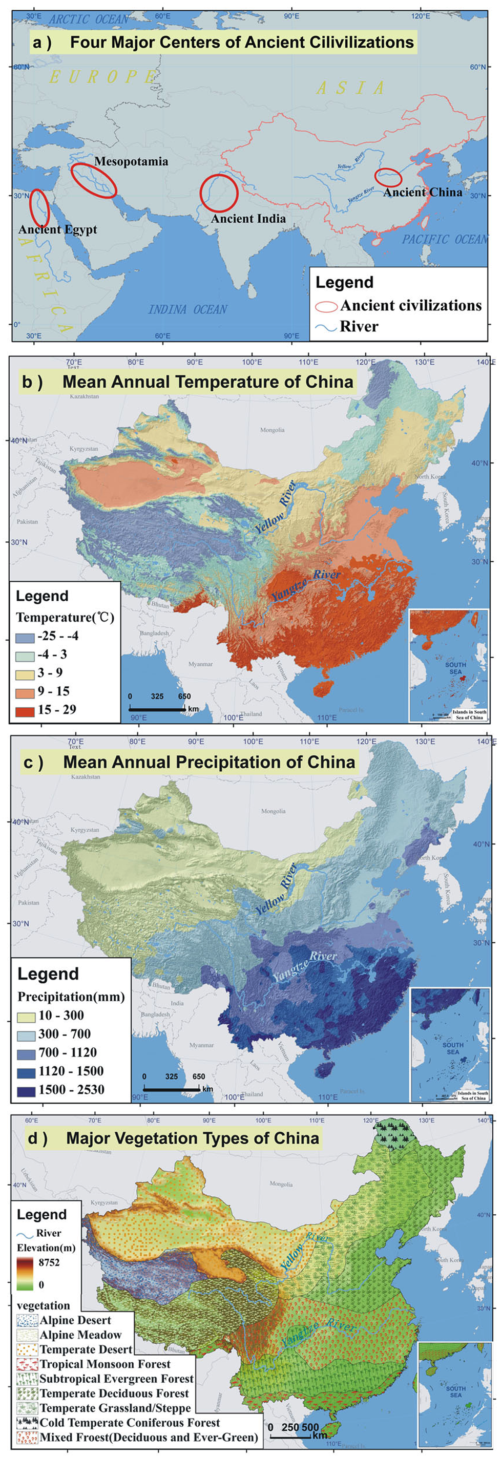
Background introductions: (a) four major centers of ancient civilizations; (b) mean annual temperature of China; (c) mean annual precipitation of China; (d) major vegetation types of China.
World Climates at ~4000 cal. yr BP
Within the Ancient India cultural domain, archaeologically documented synchronous collapse of the political and economical superstructures at ~4000 cal. yr BP (cal. yr BP = calibrated calendar year before present) imply a large-scale driving mechanism (Drysdale et al., 2006; Possehl, 1997; Staubwasser and Weiss, 2006; Staubwasser et al., 2003). Although most published Holocene sequences from India and the adjacent Tibetan Plateau are ambiguous about the ~4000 cal. yr BP event (Morrill et al., 2003; Prasad and Enzel, 2006), the records from northwestern India clearly show that the climate changed from subhumid to semi-arid and from warm to cool at ~4000 cal. yr BP (Prasad and Enzel, 2006). The marine records from the Indus Delta and from the Arabian Sea strongly suggest that Southwest Asian summer monsoon strength was significantly weakened at ~4000 cal. yr BP (Gupta et al., 2003; Staubwasser et al., 2003) and the associated reduction in precipitation was speculated to be the likely cause of the collapse of the Indus Valley civilization (Possehl, 1997; Staubwasser et al., 2003). Lakes of monsoonal eastern Africa are reported to preserve evidence of a widespread ~4000 cal. yr BP drying phase (Gasse, 2000) and the dry event is also preserved in Tropical African lake records (Marchant and Hooghiemstra, 2004; Russell et al., 2003) and also in a Kilimanjaro ice core (Thompson et al., 2002).
The ~4000 cal. yr BP event is particularly well documented in a marine sediment core from the Gulf of Oman of the Arabian Sea (Cullen et al., 2000). A detailed record of the Holocene variations in regional dust export documents a dramatic increase in eolian dolomite and carbonate, which commenced at ~4000 cal. yr BP, and an enhanced regional aridity is also indicated by increased eolian quartz deposition in nearby Lake Van at the headwaters of the Tigris River and also by paleoclimate records from the Levant. This dry interval retrieved from the Gulf of Oman is consistent with an event of evaporation increase in the Near East and Mediterranean areas. At ~4000 cal. yr BP stable oxygen isotope values from surface dwelling foraminifera in the northern Red Sea show a sharp increase pointing to a strong positive salinity anomaly at the sea surface (Arz et al., 2006), and at the same time Dead Sea level dropped as much as 45 m (Enzel et al., 2003). One of the best recorders of rainfall changes in this area is the speleothem record from Soreq cave (southern Israel) (Bar-Matthews et al., 1999) that reveals a dry event at ~4100 cal. yr BP. Stable isotope data from a calcite flowstone collected from the well-watered Alpi Apuane Karst of central-western Italy indicate that this dry event was also recorded in the Mediterranean area (Drysdale et al., 2006). The combined archaeological and paleoclimate evidence implicates abrupt climate change as a key factor leading to the demise of the highly complex society within the Mesopotamian domain (deMenocal, 2001; Weiss and Bradley, 2001).
This ~4000 cal. yr BP drought, primarily retrieved from northern mid-latitudes of the Old World, seems to have extended to the Tropics (Kröpelin et al., 2008; Russell et al., 2003; Thompson et al., 2002), to South America (Irarte et al., 2004; Marchant and Hooghiemstra, 2004). But, similar evidence has yet to be recovered from western Africa (Russell et al., 2003), and parts of South America seem to have experienced a wetter climate at that time (Marchant and Hooghiemstra, 2004). In a few regions and archives an abrupt dry event can be observed. For example, in the Eastern Mediterranean/Near East, the time interval at ~4000 cal. yr BP is characterized by a pronounced shift to more arid conditions (Arz et al., 2006; Bar-Matthews et al., 1999; Cullen et al., 2000; Enzel et al., 2003). However, climate changes at ~4000 cal. yr BP are rather a part of a long-term trend in many other cases. The climate change at ~4000 cal. yr BP in the North Atlantic realm for example appears to be a part of the multicentennial to millennial timescale climate variability (Bond et al., 2001).
World cultures at ~4000 cal. yr BP
The records from the Ancient India cultural domain suggest that the Indus Valley civilization peaked at 4600–3900 cal. yr BP. After ~3900 cal. yr BP, signs of a gradual decline began to emerge. The Indus Valley civilization of planned cities came to an end around 3700 cal. yr BP probably due to external invasions or more likely due to drought-resulted shortage of water supplies in the Indus basin (Kenoyer and Heuston, 2005; Possehl, 1997; Prasad and Enzel, 2006; Staubwasser and Weiss, 2006; Staubwasse et al., 2003; Wright, 2010). Within the Ancient Egypt domain, after the reigns of Userkaf and Sahure (around 4400 cal. yr BP), civil conflict undermined the unity of the kingdom. In addition, the massive building projects of the Fourth Dynasty had exceeded the capacity of the treasury and populace and, therefore, weakened the Kingdom at its roots. The final blow was believed to be a severe drought between 4200 and 4150 cal. yr BP. The result was the collapse of the Old Kingdom followed by decades of famine and strife (Dalfes et al., 1997; Drysdale et al., 2006; Stanley et al., 2003). Within the well-studied Mesopotamia domain, the first empire was established between ~4300 and ~4200 cal. yr BP under the rule of Sargon of Akkad in the Tigris and Euphrates basins and the Akkadian empire collapsed abruptly at ~4170 cal. yr BP (deMenocal, 2001; Weiss and Bradley, 2001; Weiss et al., 1993). Archaeological evidence documented widespread abandonment of the agricultural plains of northern Mesopotamia and dramatic influxes of refugees into southern Mesopotamia. Resettlement of the northern plains by a much smaller sedentary population occurred ~300 years after the collapse (after ~3900 cal. yr BP). The stratigraphic level representing the collapse at Tell Leilan (northeast Syria) is overlain by a thick (~100 cm) accumulation of wind-blown silts, suggesting a sudden shift to more arid conditions.
Modern climates of China
In order to further explore the relationship between the climatic and cultural transitions at ~4000 cal. yr BP, our attention is directed to another center (i.e. Chinese cultural domains) of the ancient civilizations. In order to understand the climatic background of Ancient China’s cultural transition at ~4000 cal. yr BP, it is necessary to provide an overview of the modern climatic background of China. The climates of China vary systematically from the south to the north and from the east to the west (Zhao and Chen, 1999). The south–north variations are controlled by the latitudes and the proximity to the oceans. The east–west variations are dependent on the topography and the proximity to the oceans. The topographic effects on the climates are expressed by environmental lapse rate and also by orographic precipitation. Topographically, China can be divided into three tiers. The Tibetan Plateau (that rises more than 4000 m above sea level) forms the highest tier. The vast area north and east of the Plateau (that drops to elevations ranging from ~2000 to ~1000 m) forms the second tier. The third tier is a vast area of rolling hills and plains with an elevation below 1000 m in the southeastern half of China.
Monsoon winds, caused by differences in the heat-absorbing capacity between continents and oceans, dominate the climates of China (Zhang and Lin, 1985). The winter monsoon brings cold and dry continental air southwestward and enhances the latitudinal dependency of the temperature variations across the entire area of China, and consequently, the mean annual temperature decreases northwestward (Figure 1b). The East Asian summer monsoon carries warm and humid air from the Pacific Ocean to the southeastern half of China, resulting in a northwestward-decreasing trend of mean annual precipitation (Figure 1c). The Southwest Asian summer monsoon brings warm and humid air from the Indian Ocean to the southwestern part of China. The high Tibetan Plateau in the west significantly lowers the temperature. As a consequence, vegetation types closely follow the aforementioned temperature–precipitation combinations (Figure 1d), i.e. warm-wet types of vegetation in the southeastern part (e.g. subtropical evergreen forests and temperate deciduous forest), cool-dry types of vegetation in the northwestern part (e.g. steppes and deserts), and alpine types of vegetation in the Tibetan Plateau (e.g. alpine desert and alpine meadow).
Precipitation variations have been historically well documented to be a major cause of natural disasters. Generally speaking, the northern and western parts of China are more prone to drought and the lower reach of the Yellow River basin and the middle and lower reaches of the Yangtze River basin are more prone to flooding (Zhang and Crowley, 1989). The precipitation variations have been closely related to the strength of the East Asian summer monsoon and the strength of the summer monsoon has been meteorologically and geologically demonstrated to be primarily modulated by the latitudinal position of the Intertropical Convergence Zone (ITCZ) (Higginson et al., 2004). The observed relationship between the El Nino–Southern Oscillations (ENSO) and the Asian summer monsoon strength seems to be modulated through the interactions between ENSO and ITCZ (Chiang and Kushnir, 2000; Ju and Slingo, 2006) and the relationships between ENSO activity and Asian droughts are convincingly demonstrated by tree-ring records (Cook et al., 2010).
A dramatic climate transition at ~4000 cal. yr bp
Our reviews focus on recently published literature on Holocene climate changes in northern China (sites 1–10 in Figure 2) and in southern China (sites 11–20 in Figure 2). The literature on Xinjiang region and on Tibetan Plateau region is not included because these two regions are not archaeologically classified as Chinese cultural domains (Chang, 1999). Our selection of the sites is based on three quality criteria: (1) reliability of chronologies, (2) validity of proxies used, and (3) high-resolution (sampling resolution and preservation of high-resolution information) (Feng et al., 2006a; Mayewski et al., 2004; Morrill et al., 2003). It is noticeable that no sites are selected from the Central Plain (i.e. Henan Province and its adjacent areas) and from North China Plain (i.e. mainly Hebei Province and Shandong Province) because of lack of sequences that pass our data quality scrutiny. Another point we want to make is about the age inconsistencies of ‘4000 cal. yr BP Event’ or ‘4.2 ka Event’ reported in this paper and also in other records. Three reasons might have resulted in the reported inconsistencies. First, the regional responses to the dramatic middle- to late-Holocene transition may have not occurred absolutely synchronously. Second, the ~4000 cal. yr BP event was indeed an abrupt dry event in some archives, but it was part of a long-term trend in some other archives. Third, the dates used to establish the chronologies may not be of equally high quality and the quality is dependent on date-sampling resolution, dating material, and even laboratory procedures. We think that the second reason may result in the age inconsistencies of the middle–late transition in most of our cases, but some of our cases legitimate the third reason. Our confidence on those dates (including the inferred ages) are assured by the facts the middle-to late-Holocene transitional event is by far the most pronouncedly expressed in the proxy records and that the neighboring events are too minor to compete for the dates (~4000 cal. yr BP). In other words, with consideration of age uncertainties (including inherited errors in 14C dates, interpolation-resultant errors, carbon-reservoir effect, and even calibration-resultant errors), the chronologies reported below are reasonably acceptable for observing the ‘4000 cal. yr BP Event’ or ‘4.2 ka Event’ in China although we are not absolutely sure whether this event should be termed as ‘4000 cal. yr BP Event’ or as ‘4.2 ka Event’. However, the validity of the first reason should not be understated. That is, we should not expect that different ecosystems in the Old World and even in China supporting different cultures should have responded to the dramatic middle- to late-Holocene climatic transition absolutely synchronously, even that the middle- to late-Holocene climatic transition was more or less synchronous on regional or hemispheric scales.

Locations of discussed paleoclimatic sequences in northern China (1: Qinghai Lake; 2: Sujiawan Section; 3: Baahar Nuur Lake; 4: Diajiaohaizi Section; 5: Daihai Lake; 6: Taishizhuang Section; 7: Bayanchagan Lake; 8: Hani Peat; 9: Jinchuan Peat; 10: Hulun Lake) and in southern China (11: Hongyuan Peat; 12: Dajiu Lake; 13: Shanbao Cave; 14: Linhuan Cave; 15: Heshang Cave; 16: Taihu Lake; 17: Xiangshui Cave; 18: Dongge Cave; 19: Huangguangyan Maar; 20: Core 255).
Northern China
According to the observed geographic coherency of the Holocene reconstructions, Qinghai Lake situated in the conjunction between the Tibetan Plateau and the Chinese Loess Plateau, the first site to be reviewed here, is ‘classified’ into the northern China category (site 1 in Figure 2). The second site to be reviewed is Sujianwan from the western part of the Chinese Loess Plateau (site 2 in Figure 2). Five of ten reviewed sequences are from the vast Inner Mongolian Plateau (sites 3–7) and three from Northeast China (sites 8–10). A Holocene pollen sequence from the Qinghai Lake shows that the Holocene Optimum vegetation started to deteriorate at ~6000 cal. yr BP and the tree-pollen concentration approached the Holocene minimum at ~4000 cal. yr BP. A noticeable dry-cool event at ~4000 cal. yr BP (site 1 in Figure 3) is clearly indicated by pollen-based temperature and precipitation indices (Liu et al., 2002; Shi and Kong, 1992; Shi et al., 1993). Eastward in the western part of the Chinese Loess Plateau where the loess/paleosol strata and the corresponding variations in the magnetic susceptibility at two sections near Lanzhou were reported to have documented two major Holocene soil forming events occurred at ~7500–~5000 14C yr BP and at ~2700–~2000 14C yr BP (Zhou et al., 1991). Owing to uncertainties in the chronologies and the qualitative nature of the magnetic susceptibility in representing paleoclimate, the authors were not able to provide more precise descriptions of Holocene climatic changes. Recent investigations in the western part of the Chinese Loess Plateau demonstrate that the Holocene sequences on valley terraces are ubiquitously composed of two complexes: upper loess-paleosol complex and lower wetland-swamp complex. The type sequence at Sujiawan site (site 2 in Figure 3) was well dated (Feng et al., 2004, 2006b), and the wetland-swamp layer is bracketed by loess depositions at the beginning (8885±55 14C yr BP) and at the end (3805±45 14C yr BP). The pollen data at the Sujiawan site show that after the domination of a deciduous forest of high density and diversity from 6560 to 5790 14C yr BP, the vegetation changed first to a Pinus-dominated forest-steppe (5790–4950 14C yr BP) and then to an Ulmus-dominated forest-steppe (from ~4950 to ~3800 14C yr BP). The vegetation has been dominated by desert-steppe since ~3800 14C yr BP with an intervening interval of steppe domination between ~2900 and ~2400 14C yr BP. In other words, a dramatic climatic transition occurred at ~3800 14C yr BP (i.e. ~4200 cal. yr BP) in the western part of the Chinese Loess Plateau.
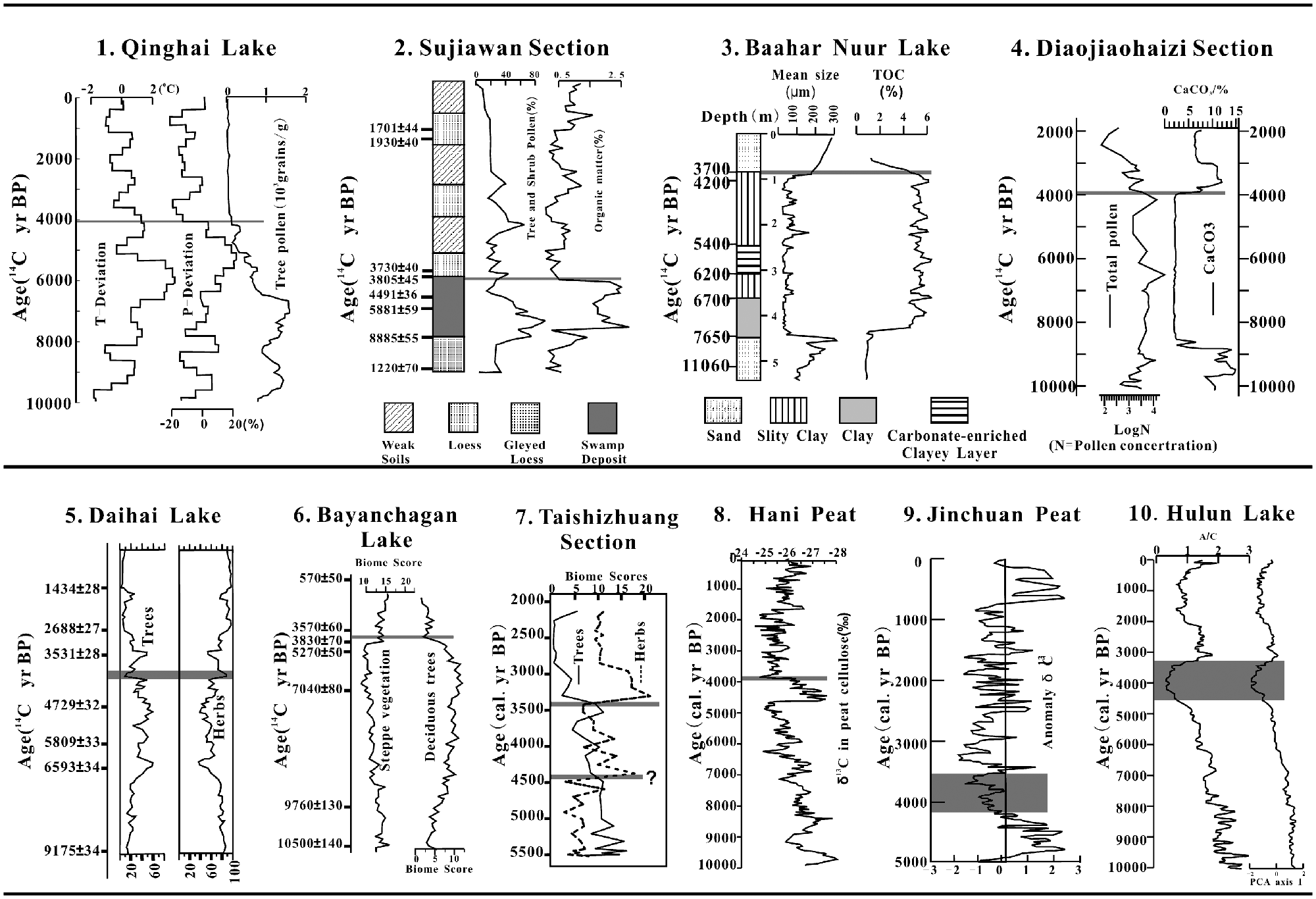
Climate proxy sequences in North China: 1: Qinghai Lake; 2: Sujiawan Section; 3: Baahar Nuur Lake; 4: Diajiaohaizi Section; 5: Daihai Lake; 6: Taishizhuang Section; 7: Bayanchagan Lake; 8: Hani Peat; 9: Jinchuan Peat; 10: Hulun Lake.
This review paper discusses five Holocene sequences from the vast Inner Mongolian Plateau. A Holocene lacustrine sequence from Baahar Nuur (site 3 in Figure 3) in the south-central part of the Inner Mongolian Plateau suggests that a lake occupied the Baahar basin between ~7650 14C yr BP and ~3700 14C yr BP and that the lake was completely desiccated at ~3700 14C yr BP (Guo et al., 2007). The Baahar Nuur desiccation at ~3700 14C yr BP (i.e. ~4000 cal. yr BP) chronologically corresponds to the carbonate-indicated lake desiccation at nearby Diaojiaohaizi section (site 4 in Figure 3) and the lake desiccation at the Diaojiaohaizi site is well corroborated by pollen concentration that dropped drastically at the inferred age of ~4000 cal. yr BP (Wang and Wang, 1992; Zhang et al., 1997). The pollen data from nearby Daihai Lake (site 5 in Figure 3) show that mixed coniferous and broadleaved forests dominated the landscapes between ~7900 and ~4450 cal. yr BP and steppe vegetation replaced the forests at ~4450 cal. yr BP (Xiao et al., 2004, 2006). But, if the measured carbon reservoir effect of 360 years is applied, the age of pollen-indicated drying at the Daihai site should be statistically similar to the inferred age of ~4000 cal. yr BP at other sites (Xiao, personal communication, 2008). A drastic drying is also reported to have occurred at an inferred age of ~4000 cal. yr BP at nearby Bayanchagan Lake (site 6 in Figure 3) in the eastern part of the Inner Mongolian Plateau (Jiang et al., 2006). The drying is well documented by a drastic increase in steppe biome score and by the corresponding decrease in deciduous tree biome score. This abrupt transition is also unequivocally corroborated by a jumping increase in carbonate concentration at ~4000 cal. yr BP (Jiang, unpublished data, 2008). A relatively well-dated and high-resolution pollen sequence from Taishizhuang site (a desiccated peat) at the southeastern margin of the Inner Mongolian Plateau (site 7 in Figure 3) shows that a temperate deciduous forest dominated the landscape between ~5700 and ~4400 cal. yr BP and that the forest was replaced by steppe-forest vegetation at ~4400 cal. yr BP (Jin and Liu, 2002; Tarasov et al., 2006). But, it is quite notable that the most dramatic change occurred at ~3400 cal. yr BP (not at ~4000 cal. yr BP) when the tree component nearly completely disappeared.
Three sequences to be reviewed from Northeast China (sites 8–10 in Figure 2) are all well dated. The peat δ13C signature (Hong et al., 2005) from Hani Peat (site 8 in Fig– 3), a proxy for East Asian summer monsoon strength, suggests that the Holocene East Asian summer monsoon strength has an arch-shaped trend. That is, a decreasing trend from 11,500 to 4800 cal. yr BP and an increasing trend from 3900 to 0 cal. yr BP are interrupted by an extremely wet period lasting from 4800 to 3900 cal. yr BP. The peat δ13C curve marked the two driest intervals of the entire Holocene: the first one lasting from 5200 to 4800 cal. yr BP and the second one lasting from 3900 to 3300 cal. yr BP. The peat δ13C signature at nearby Jinchuan Peat (site 9 in Figure 3) that covers the history of the past 5000 years (Hong et al., 2001) suggests that an extremely wet period lasted from 4900 to 4100 cal. yr BP and the extremely wet period was followed by a dry period lasting from 4100 to 3700 cal. yr BP. At Hulun Lake (site 10 in Figure 3) the A/C ratio curve and pollen PCA-2 curve (i.e. drought-tolerant vegetation domination), as well littoral ostracode domination, unequivocally marked the period between 4300 and 3350 cal. yr BP as the driest period of the entire Holocene (Wen et al., 2010a, 2010b). Although there are inconsistencies, ~4000 cal. yr BP seemed to be a shared dry phase among the three sets of data from Northeast China (Hani, Jinchuan, Hunlun).
Southern China
An and his colleagues (An et al., 2000) reviewed early publications and concluded that the Holocene East Asian summer monsoon retreated progressively from the northwest to the southeast of China, but the data from southern China they used suffered severely from two major deficiencies: (1) poorly dated and (2) low sampling resolution (Feng et al., 2006a). But, recent works on lacustrine and peat sequences and especially on cave speleothem sequences from southern China assured our confidence in the quality of the data and our following reviews are based on these high-quality data.
Again, according to the observed geographic coherencies, Hongyuan Peat from the eastern margin of the Tibetan Plateau is classified into the southern-China category. The δ13C records in both peat cellulose and C. mullieensis cellulose from Hongyuan site (site 11 in Figure 4) suggest a dramatic drying (or/and cooling) at 4200–4000 cal. yr BP and the drying was interpreted to be a result of weakening of the Southwest Asian summer monsoon (Hong et al., 2003). The authors particularly noted that this drying (or/and cooling) was the strongest among all of the δ13C-documented Holocene drying events. A pollen sequence from Dajiu Lake in the middle reach of the Yangtze River basin also marked a relatively dramatic drying (or/and cooling) that started at an inferred age of ~4100 cal. yr BP (Zhu et al., 2007). This drying is characterized by a drastic decrease in tree and fern components (site 12 in Figure 4). This dramatic drying (or/and cooling) event is chronologically well corroborated by nearby Shanbao Cave speleothem δ18O-recorded cooling (or/and drying) at ~4100 cal. yr BP (Shao et al., 2006) (site 13 in Figure 4). This ~4100 cal. yr BP cooling (or/and drying) is also mirrored by Linhua Cave speleothem δ18O record (site 14 in Figure 4) that expressed a relatively dramatic drying (or/and cooling) at ~4000 cal. yr BP although the most dramatic drying (or/and cooling) occurred at ~3350–3000 cal. yr BP at the Linhua Cave (Cosford et al., 2008). Similarly, nearby Heshang Cave speleothem δ18O record (site 15 in Figure 4) also documented a relatively dramatic event at ~4000 cal. yr BP and again the most dramatic event occurred at ~3600–3100 cal. yr BP (Hu et al., 2008). Further eastward at Taihu Lake in the lower reach of the Yangtze River basin, pollen data (Chen et al., 2005; Tao et al., 2006) also exhibit a relatively dramatic vegetation change at ~3700 14C yr BP (i.e. ~4000 cal. yr BP). Specifically, the grass components peaked and the evergreen woody components dropped at ~3700 14C yr BP (site 16 in Figure 4).

Climate proxy sequences in South China: 11: Hongyuan Peat; 12: Dajiu Lake; 13: Shanbao Cave; 14: Linhuan Cave; 15: Heshang Cave; 16: Taihu Lake; 17: Xiangshui Cave; 18: Dongge Cave; 19: Huangguangyan Maar; 20: Core 255.
Three sequences from the southwestern part of China are of high qualities. The δ18O time series of a speleothem sequence from Xiangshui Cave in Guangxi Province (site 17 in Figure 4) well documented the late-Holocene cooling that started at ~4000 cal. yr BP. The late-Holocene cooling mainly occurred within a relatively wet period spanning from ~4500 to ~1000 cal. yr BP, as indicated by the δ13C time series of the speleothem sequence (Zhang et al., 2004). The ~4000 cal. yr BP transition and the late-Holocene cooling are best manifested by another speleothem sequence from Dongge Cave in Guizhou Province (site 18 in Figure 4). The δ18O time series indicates that the drying (or/and cooling) at 4200–4000 cal. yr BP was the strongest among all of the δ18O-documented Holocene drying (or/and cooling) events (Dykoski et al., 2005; Wang et al., 2005). The southernmost site is Huguangyan Maar (site 8; 21°09′N and 110°17′E) in Guangdong Province and the pollen data divide the Holocene into three stages (site 19 in Figure 4): (1) warming and wetting early Holocene between ~11,600 and ~7800 cal. yr BP (average woody component = 56%), (2) moderately warm and wet (but cooler and probably drier than the preceding period) middle Holocene between ~7800 and ~4100 cal. yr BP (average woody component = 43%), and (3) drying (and probably also cooling) late-Holocene since ~4100 cal. yr BP (average woody component = 28%) (Wang et al., 2007; Zheng et al., 2003). The relatively dramatic late-Holocene transition (drying and probably also cooling) that lasted from 4200 to 3300 cal. yr BP in the Huguangyan Maar area is relatively well corroborated by the proxy data from nearby South China Sea (Core MD972146; 20°07′N and 117°23′E) where a relatively warm middle Holocene (between ~6000 and ~4000 cal. yr BP) was followed by a relatively cool late Holocene (Lin et al., 2006). Far further eastward to Taiwan Strait, a deep sea core sequence (Core 255; 25°12′N and 123°07′E) from East China Sea (site 20 in Figure 4) also exhibits a marked cooling event that lasted from ~4500 to ~3300 cal. yr BP, as indicated by a sharp decrease in the abundance of P. obliquiloculata (Jian et al., 2000). This drastic cooling was interpreted to reflect the late-Holocene intensification of the Asian winter monsoon.
It should be particularly pointed out that the aforementioned pollen data from lacustrine sequences and the δ18O time series from cave speleothem sequences in southern China seem to indicate drying climates in the middle- to late-Holocene transition at ~4000 cal. yr BP. But, geologically documented water-level rises and the associated flooding in the Taihu Lake area in the lower reach of Yangtze River basin and in the Dongtinghu Lake area in the middle reach of Yangtze River basin seemingly lend a support to the notion that a cool and wet climate might have dominated southern China at ~4000 cal. yr BP (Stanley and Chen, 1996; Stanley et al., 1999; Zhu et al., 1997, 2007). The possible reconcilable interpretation is that the effective soil moisture was probably raised because of lowered temperature although the atmospheric precipitation was probably reduced at the middle- to late-Holocene transition.
Cultural changes at ~4000 cal. yr bp
As one of the major ancient civilization centers, Chinese cultural domains are also reported to have experienced profound changes towards the end of the Longshan period (at ~4000 cal. yr BP). Most of these Neolithic cultures (i.e. Longshan Culture and contemporaneous ones) were chiefdom-like societies (Chang, 1999; Liu, 1996, 2000, 2004), and they should have normally evolved into more complex societies such as that of the Henan Longshan culture of the Central Plain from which the Erlitou Culture (i.e. a state-level-like society) evolved (Liu, 2000; Liu and Chen, 2003; Liu and Xu, 2007; Liu et al., 2004; Wu and Liu, 2001, 2004). However, most of these cultures collapsed or derailed at ~4000 cal. yr BP. The collapse of a social system is defined as drastic decreases in human population, in economic activity and in sociopolitical complexity across a vast area over a short period of time (Diamond, 2005). A social derailment is defined as a considerable deviation or even retraction from an observed trend of cultural advancement (Wang, 2004). In the Chinese context, social collapse or derailment of Neolithic complex agricultural societies are indicated by the following signs (Liu and Chen, 2003; Wang, 2004; Wu and Liu, 2001, 2004). First, fewer archaeological sites were found and those sites found are located in more restricted areas. Second, less sophisticated materials were utilized than those used in immediate preceding cultural phases. Third, large-scale and more sophisticated architectures disappeared. Fourth, in northern semi-arid China, the collapse of the agricultural cultures was followed by widespread pastoralism or by an agriculture-pastoralism transition (An et al., 2004, 2005; Fang and Sun, 1998; Hou et al., 2009; Liu, 2004; Liu et al., 2005; Shui, 2000; Tian, 2000).
This review paper focuses on China’s archaeological cultural domains and the domains include the Yellow River basin and the lower and middle reaches of the Yangtze River basin. Within the Yellow River basin, three cultural regions to be discussed are: Gansu-Qinghai Cultural Region (i.e. region 1 in map (a) of Figure 5) in the upper reach, South-Central Inner Mongolian Cultural Region (i.e. region 2 in map (a) of Figure 5) in the upper-middle reach, and Haidai Cultural Region (i.e. region 6) in the lower reach. Within the Yangtze River basin, two regions to be discussed are: Middle Yangtze Cultural Region (i.e. region 4) and Lower Yangtze Cultural Region (i.e. region 5). In addition, the Southeastern Inner Mongolia Cultural Region (i.e. region 3) in northeastern China is also discussed. The Central Plain Cultural Region (i.e. region 7) in the lower-middle reach of the Yellow River basin is singled out for a more detailed discussion. The Chengdu Plain Cultural Region in Sichuan Province (i.e. region 8) is precluded from the evaluation because of the lack of well-dated cultural sequences. Our divisions of cultural regions are roughly based on those by Yan (1997) and Chang (1999).
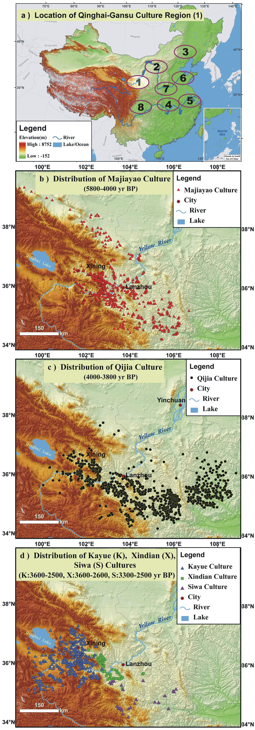
Cultural variations in Gansu-Qinghai Cultural Region: (a) locations of cultural regions; (b) distribution of Majiayao Culture; (c) distribution of Qijia Culture; (d) distributions of Kayue Culture, Xindian Culture, and Siwa Culture.
A particular note should be made here regarding the chronologies of the cultural divisions. We adopted the chronological frameworks provided by the Chinese Cultural Atlases. The Atlases are composed of 33 subatlases, one subatlas for each one of 33 governmental provinces. The Atlases were compiled according to the centrally administered editorial guidelines in which the rules of establishing chronological frameworks were set. Specifically, the statistical method was used to define the chronological framework of a culture if sufficient radiocarbon dates were obtained. For instance, the chronological frameworks for each of the following cultures were based on more than 40 radiocarbon dates: Dawenkou (~80 dates), Shangdong Longshan (>40 dates), Liangzhu (~50 dates), Maqiao (>40 dates), and Erlitou (>50 dates). Nevertheless, statistical method is not applicable when a culture is not sufficiently dated. The chronological framework was then attempted based on the limited dates with references to the large-scale cultural contexts. A typical example is the Southeastern Inner Mongolian Cultural Region where the Hongshan Culture was defined based on eight dates and the Xiaoheyan Culture only on three dates. Apparently, more dates are needed for those insufficiently dated cultures. The data of the archaeological sites are also from the Chinese Cultural Atlases with references to more recent updates of the data.
Northern China
This geographic region includes three cultural domains: Gansu-Qinghai Culture Region (region 1 in map (a) of Figure 5), South-Central Inner Mongolian Region (region 2 in map (a)), and Southeastern Inner Mongolia Region (region 3 in map (a)). In the Gansu-Qinghai Culture Region, the Majiayao Culture, a westward extension of the Yangshao Culture, is chronologically constrained by 12 dates (Zhang, 2004) and the time span ranges from ~5800 to ~4000 cal. yr BP (map (b) in Figure 5; data sources for archaeological sites and chronologies: Chinese Cultural Atlas Editorial Committee of State Administration of Cultural Heritage, 2006, 2011). Its economy was based on farming and animal husbandry and is especially well-known for its mass production of pottery (Shui, 2000). The succeeding Qijia Culture, whose chronology (~4000–~3800 cal. yr BP) was constrained by four dates, was characterized by advanced technologies of tool making. It is quite noticeable that the Qijia Culture further extended to its eastern part (map (c) in Figure 5) with considerably more archaeological sites in comparison with the preceding Majiayao Culture. The Qijia Culture retreated from the western part of the Gansu-Qinghai Cultural Region and suffered a considerable reduction in population size during the late stage (An et al., 2004, 2005; Hou and Liu, 2004; Hou et al., 2009; Liu et al., 2005, 2010). After a relatively brief hiatus (~200 years), three different cultures emerged in this region (map (d) in Figure 5). The first one was the Kayue Culture, whose chronology (3600–2500 cal. yr BP) was constrained by six dates. It was a predominantly pastoralism culture that occupied the eastern margin of the Tibetan Plateau. The second one was the Xindian Culture, whose chronology (3600–2600 cal. yr BP) was constrained by seven dates (Shui, 2001). It occupied a very limited area around the present Lanzhou City and its economy was agriculture-based. The third one was the Siwa Culture, whose chronology (3300–2500 cal. yr BP) was constrained by seven dates. The culture had a husbandry-based economy with strong agricultural components and sparsely occupied the western part of the Chinese Loess Plateau where the preceding (Qijia) archaeological sites were quite dense. It should be noted that a cultural atavism occurred after 3800 cal. yr BP, i.e. succeeding culture(s) reversed the advancing paths of the preceding culture(s). As a typical example of cultural atavism, the quality of the pottery vessels unearthed from those three cultures is much lower than that from the preceding Qijia Culture (An et al., 2005; Shui, 2000).
The Haishengbulang Culture (5500–5000 cal. yr BP yr BP) in the South-Central Inner Mongolian Cultural Region (region 2 in map (a) of Figure 5) was a mixture of primitive agriculture, husbandry and hunting (data source for archaeological sites and chronologies: Chinese Cultural Atlas Editorial Committee of State Administration of Cultural Heritage, 2003). The succeeding Laohushan-Dakou I Culture (4500–4000 cal. yr BP) was a relatively advanced agricultural society that occupied a relatively restricted areas of river valleys. The unearthed sacrificial altars and specialized workshops implicate a well-organized society. But, the Laohushan-Dakou I Culture suddenly disappeared at ~4000 cal. yr BP and the region was later occupied by the Zhukaigou Culture (4000–3500 cal. yr BP). The Zhukaigou Culture was characterized by agro-pastoralism, and it further extended to hilly areas of high elevation during late stage (Fang and Sun, 1998; Tian, 2000; Tian and Tang, 2001; Wang, 2004). Two notes should be mentioned here. First, the archaeologically documented dramatic cultural transition at ~3500 cal. yr BP was considerably more dramatic than the one that occurred at ~4000 cal. yr BP (Fang and Sun, 1998; Lian and Fang, 2001; Zhang et al., 1997). Second, the number of unearthed archaeological sites in this region is quite small (e.g. only 22 sites of the Laohushan-Dakou I Culture) and the sites are not well dated (Tian and Guo, 2004).
In the Southeastern Inner Mongolia Culture Region (region 3 in map (a) of Figure 5), the Hongshan Culture, a relatively well-developed agricultural society (6700–5000 cal. yr BP), was followed by the Xiaoheyan Culture (5000–4500 cal. yr BP) (data source for archaeological sites and chronologies: Chinese Cultural Atlas Editorial Committee of State Administration of Cultural Heritage, 2003), and the latter (i.e. Xiaoheyan) showed strong signs of persistent cultural derailment. These signs include dramatic reductions both in the number of archaeological sites and in the areal extent of cultural occupation. The following Lower Xiajiadian Culture (4200–3500 cal. yr BP), a society with millet farming-based economy heavily supplemented with animal husbandry, shifted its cultural centers to more southward locations. The succeeding Upper Xiajiadian Culture (3200–2500 cal. yr BP), a Bronze Age culture, was characterized by a major shift from sedentary agriculture to pastoral nomadism that extended to the higher elevations (Li et al., 2006; Han et al., 2007; Nelson, 1995). It should be noted that the cultural derailment during the Xiaoheyan Culture (5000–4500 cal. yr BP) and a possible (not well dated though) cultural hiatus (4500–4200 cal. yr BP) do suggest a major cultural shift. But, a considerably more dramatic cultural shift occurred at 3500–3200 cal. yr BP and the shift was suggested by three signs: (1) the collapse of the agriculture-based Lower Xiajiadian Culture at ~3500 cal. yr BP, (2) a ~300 yr cultural hiatus (3500–3200 cal. yr BP), and (3) the rise of pastoral nomadism at ~3200 cal. yr BP. It should also be noted that although unearthed sites in this cultural region are numerous, the the cultures are not suffificiently dated.
Southern China
This geographic region includes the Middle Yangtze Cultural Region (region 4 in map (a) of Figure 6) and the Lower Yangtze Cultural Region (region 5 in map (a) of Figure 6). The Qujialing Culture (5100–4500 cal. yr BP), whose chronology was constrained by five dates, occupied the middle reach of the Yangtze River basin and extended northward to the southern part of the present Henan Province (map (b) in Figure 6; data sources for archaeological sites and chronologies: Chinese Cultural Atlas Editorial Committee of State Administration of Cultural Heritage, 1991, 2002; Guo, 2005; Zhang, 2004). The economy was a rice cultivation-dominated agriculture with some components of husbandry and hunting. The succeeding Shijiahe Culture, whose chronology (4500–4000 cal. yr BP) was constrained by six dates, was a rice cultivation-based society with fewer archaeological sites unearthed (map (c)). The most distinctive feature of the Shijiahe Culture is a large moated and walled urban settlement with an area of ~120 ha. But, all of the walled settlements, large and small, were abandoned at ~4000 cal. yr BP (map (d)) (Deng et al., 2009; Li, 1997; Wu and Wu, 1998; Zhu et al., 2007). After a ‘post-Shijiahe culture’ that is not well defined yet (Wang, 2007), a rather advanced culture (i.e. Chu Culture) emerged in this region at ~3350 cal. yr BP.

Cultural variations in Middle Yangtze Cultural Region: (a) locations of cultural regions; (b) distribution of Qujialing Culture; (c) distribution of Shijiahe Culture; (d) distributions of Shang Culture.
In the Lower Yangtze Cultural Region (region 5 in Figure 6), the Songze Culture, whose chronology (5800–5000 cal. yr BP) was constrained by four dates, was a relatively advanced rice-based agricultural society and succeeded by the Liangzhu Culture (data sources for archaeological sites and chronologies: Chinese Cultural Atlas Editorial Committee of State Administration of Cultural Heritage, 2008a; Guo, 2005; Zhang, 2004). The well-dated (~50 dates) Liangzhu Culture (5000–4000 cal. yr BP) was the last Neolithic jade culture in the lower reach of the Yangtze River basin. The culture was highly stratified as indicated by the facts that jade, silk, ivory and lacquer artifacts were found exclusively in elite burials and that pottery was common in the burials of commoners. The culture possessed advanced agricultural practices including irrigation, paddy rice cultivation and aquaculture. A recently discovered Liangzhu walled settlement covering an area of ~290 ha further illuminates the glory of the Liangzhu Culture. The well-dated (>40 dates) Maqiao Culture (4000–3000 cal. yr BP) was so different from the preceding Liangzhu Culture and its cultural root was traced to the indigenous culture in the southwestern part of Zhejiang Province. The Maqiao Culture inherited some features from the preceding (Liangzhu) culture and incorporated some other features from the contemporaneous Yueshi Culture in Shandong Province and also from the contemporaneous Erlitou Culture in Henan Province (Stanley and Chen, 1996; Stanley et al., 1999; Zhang et al., 2005). A cultural atavism occurred after the Liangzhu Culture. That is, all of sophisticated artifacts including jades and ivories were absent from the Maqiao Culture in which low-quality potteries were the signature artifacts (Li, 1997; Yu, 1992; Yu et al., 2000).
Middle–lower and lower reaches of the Yellow River Basin
This geographic region includes the Haidai Cultural Region in the lower reach of the Yellow River basin (region 6 in map (a) of Figure 7) and the Central Plain Cultural Region in the lower-middle reach of the Yellow River basin (region 7 in map (a) of Figure 7). It should be particularly noted that the cultures in this geographic region were well dated. For example, Dawenkou Culture was defined by ~80 dates, Longshan Culture by >40 dates, and Erlitou Culture by >50 dates. In the Haidai Cultural Region, the Dawenkou Culture (6100–4600 cal. yr BP) (map (b) in Figure 7; data source for archaeological sites and chronologies: Chinese Cultural Atlas Editorial Committee of State Administration of Cultural Heritage, 2008b) was a relatively advanced millet cultivation- dominated agricultural society and succeeded by the Longshan Culture (map c). The term ‘Longshan Culture’ is a general reference to several regional cultures: Shandong Longshan (4600–4000 cal. yr BP), Henan Longshan (4800–4000 cal. yr BP) and Taosi (Shanxi) Longshan (4400–4000 cal. yr BP) (Gao, 2008; Xie and He, 2004). The distinctive feature of the Shangdong Longshan Culture was the high level of skills in pottery making. Fast-speed potters’ wheels were first used. The vessels of eggshell thinness may be the finest earthenware pottery ever made and the thinness of the earthenware body was strengthened through the use of a reduced-oxygen firing and carbonization process that produced a completely black surface. The Longshan population reached the Neolithic peak and started to decline sharply toward the end of the Longshan time when the high-quality black-surface pottery in ritual burials completely disappeared (Gao, 2008; Gao et al., 2007; Yu, 1992; Zhang, 2004). The succeeding Yueshi Culture (4000–3500 cal. yr BP) had a significantly reduced size of estimated population and also considerably shrunk areal extent of occupation (map (d)). Strong signs of cultural atavism were also detected in the Yueshi Culture.
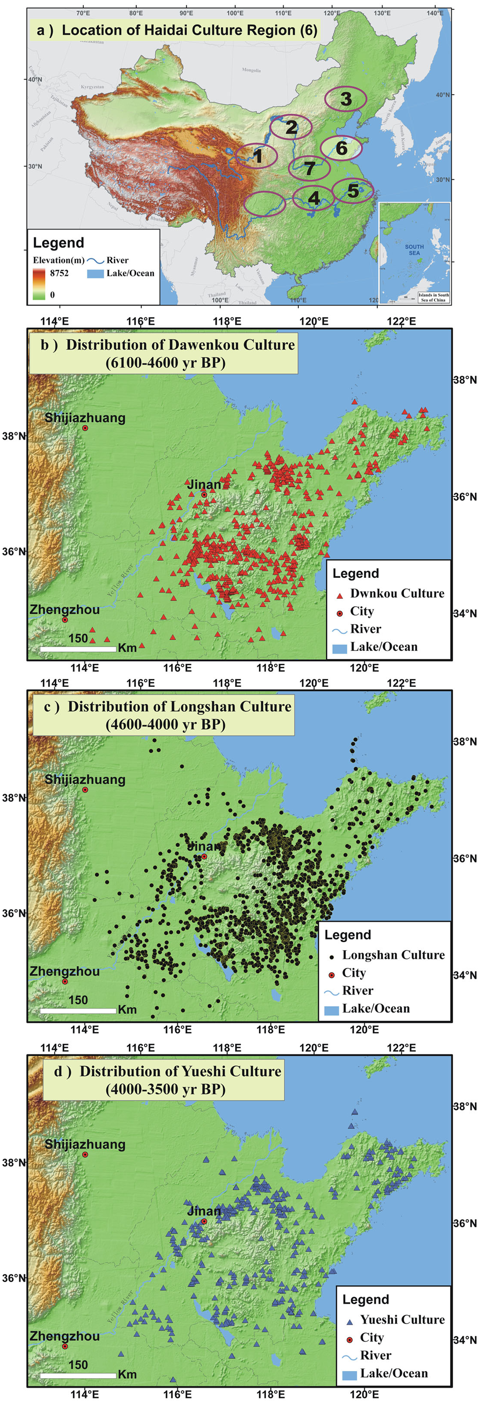
Cultural variations in Haidai Cultural Region: (a) locations of regions; (b) distribution of Dawenkou Culture; (c) distribution of Longshan Culture; (d) distributions of Yueshi Culture.
In the Central Plain Cultural Region, the Yangshao Culture (7000–5000 cal. yr BP) (dark triangles in map (b) of Figure 8) co-existed with the Dawenkou Culture (6300–4500 cal. yr BP) in the central Henan Province (yellow triangles in map (b) of Figure 8) during its late stage, the latter (i.e. Dawenkou Culture) being centered in the Haidai Cultural Region. The Qujialing Culture (5100–4500 cal. yr BP) that belonged to the Middle Yangtze Cultural Region (red triangles in map (b)) extended to the southern part of the Henan Province (data source for archaeological sites and chronologies: Chinese Cultural Atlas Editorial Committee of State Administration of Cultural Heritage, 1991). The succeeding Henan Longshan Culture (4800–4000 cal. yr BP) also reached the Neolithic peak both in population size and occupation area (map (c) in Figure 8). In sharp contrast to the surrounding regions where the contemporaneous cultures collapsed or derailed, a cultural continuity from the late Longshan Culture, through the Xinzhai Phase, to the Erlitou Culture in the Central Plain Cultural Region is well documented (Lee et al., 2007; Liu et al., 2004; Pan and Gao, 2008). That is, the Henan Longshan Culture (i.e. a chiefdom-like society) made a forward move to the Erlitou Culture (i.e. a state level-like society) (map (d) in Figure 8).

Cultural variations in Central Plain Cultural Region: (a) locations of cultural regions; (b) distributions of Yangshao, Dawenkou and Qujialing Cultures; (c) distribution of Longshan Culture; (d) distributions of Erlitou Culture.
Cultural transitions at ~4000 cal. yr BP and nature of Erlitou Culture
Dramatic cultural transitions did occur at ~4000 cal. yr BP in the Chinese archaeological domains as summarized in Figure 9. The Qijia Culture (4000–3800 cal. yr BP) in the Gansu-Qinghai Cultural Region suffered a considerable reduction in population size during the late stage. After a relatively brief hiatus (~200 years), three different cultures emerged in this region and the largest one (i.e. Kayue Culture) of the newly emerged three cultures was a pastoralism culture that occupied the eastern margin of the Tibetan Plateau. In the South-Central Inner-Mongolian Cultural Region, the Laohushan-Dakou I Culture (4500–4000 cal. yr BP), an advanced agricultural society, suddenly disappeared. The documented cultural atavism during the Zhukaigou Culture further suggests a dramatic cultural change at ~4000 cal. yr BP although a considerably more dramatic cultural transition occurred at ~3500 cal. yr BP. In the Southeast Inner-Mongolian Cultural Region, the persistent cultural derailment during the Xiaoheyan Culture (5000–4500 cal. yr BP) and a possible (not well dated though) cultural hiatus (4500–4200 cal. yr BP) suggest a major cultural shift although a more dramatic cultural shift occurred at 3500–3200 cal. yr BP. The abandonment of walled settlements in the Middle Yangtze Cultural Region at ~4000 cal. yr BP and the lack of advanced cultures for 650 years (~4000–~3350 cal. yr BP) marked a dramatic cultural transition at ~4000 cal. yr BP. The disappearance of the glorious Liangzhu Culture (5000–4000 cal. yr BP) and the cultural atavism occurred during the succeeding Maqiao Culture (4000–3000 cal. yr BP) also marked a dramatic cultural transition at ~4000 cal. yr BP in the Lower Yangtze Cultural Region. The Shandong Longshan Culture (4600–4000 cal. yr BP) in the Haidai Cultural Region (i.e. the Lower Reach of the Yellow River basin), whose population reached the Neolithic peak and whose pottery-making techniques were rather advanced, was replaced by the Yueshi Culture (4000–3500 cal. yr BP) that had much smaller size of population and produced much lower quality of pottery, suggesting a dramatic cultural transition at ~4000 cal. yr BP.
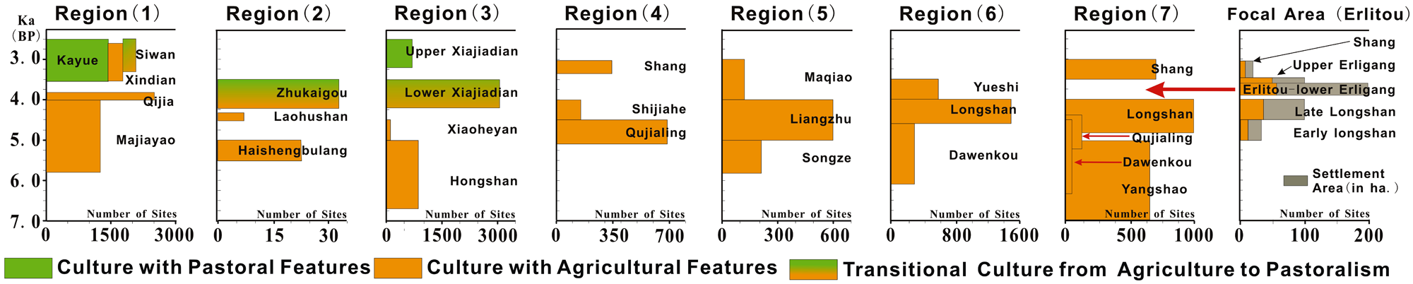
Spatial and temporal comparisons of cultural variations in Chinese cultural domains. Three features can be observed: (a) pastoralism-dominated cultures replaced agriculture-based cultures at ~4000 cal. yr BP in northern China (i.e. regions 1, 2, 3); (b) number of archaeological sites dropped dramatically at ~4000 cal. yr BP in lower and middle reaches of the Yangtze River basin (i.e. regions 4 and 5) and also in lower and lower-middle reaches of the Yellow River basin (i.e. regions 6 and 7); (c) the number of large settlements peaked during the period of the Erlitou Culture in Central Plain (i.e. Focal Area – the last diagram).
In striking contrast to all of the aforementioned cultures that either collapsed or detailed at ~4000 cal. yr BP (Figure 9), the Erlitou Culture that occupied a very limited area (i.e. the yellow dash line-circled area in map (d) of Figure 8) evolved forward from the Henan Longshan Culture (i.e. the last diagram in Figure 9). Liu and her colleagues (Liu, 1996, 2000, 2004; Liu and Chen, 2003; Liu and Xu, 2007; Liu et al., 2004) argued that the Erlitou Culture definitely represent the emergence of a state-level-like society. Their arguments are as follows. First, settlement hierarchy changed from two- or three-tiered systems in the late Longshan Culture to a four-tier system in the Erlitou Culture, suggesting the development of centralized political and economic control. Second, although the total site number decreased dramatically from the Henan Longshan Culture to the Erlitou Culture, the Erlitou population became more nucleated at the regional level with rapid development of urbanism. Third, the political structure changed from the coexistence of multiple competing polities to one in which a single large center dominated over smaller centers over a broad region. Fourth, ceramic styles changed from diversity to relative uniformity, implying an increase in craft specialization and standardization of production. Fifth, the society became more stratified as indicated by the tight association between symbolic objects and social status.
Summary and discussion
Cultural transitions and climate changes
The success of a culture depends on the interplay among three sets of factors: (1) cultural dynamics, (2) socioeconomic factors, and (3) carrying capacity factors (Allan, 2007; Liu, 2000, Liu and Chen, 2003; Liu et al., 2004; Lu, 2007; Rosen, 2007). It would thus be too simplistic to claim that all episodes of societal change or cultural collapse are driven by climate-related events. So often, the competing relationships between the level of socio-economic resilience and the magnitude of carrying capacity-related and climate-induced disasters determine the outcomes (Morrison, 2006). Of course, there are plenty of Chinese historic examples of societal failures that were most likely driven by non-climatic factors and the examples include the demise of the Qin Dynasty (at ~200
Holocene climatic trend and rhythms
A recent comprehensive review (Wanner et al., 2008) shows that after high temperatures during the early Holocene, the summertime temperature in the northern high latitudes has decreased almost linearly during past ~6000 years until the last millennium. A drying trend of past ~6000 years is abundantly documented in many records from the northern subtropics and tropics. The cooling trend in higher latitudes is dictated by the orbit-determined decline in the boreal summer isolation and the drying trend in lower latitudes is most likely indirectly associated with the declining trend in the boreal summer isolation that effectively reduced water vapor availability in the precipitation-pro systems (Kutzbach and Guetter, 1986; Kutzbach and Liu, 1997). The reconstructed anti-phase relationship between the El Nino–Southern Oscillations (ENSO) in the Pacific and the North Atlantic Oscillations (NAO) in the Atlantic may further explain the cooling trend at higher latitudes and the drying trend in lower latitudes. Specifically, the reconstructed Holocene history of ENSO (Koutavas et al., 2006; Rein et al., 2005) shows a clear positive trend indicating a shift from lower ENSO activities during the mid Holocene (6000+ ~ 4000 cal. yr BP) to higher ENSO activities during the late Holocene (i.e. the past 4000 years), whereas the reconstructed history of NAO (Rimbu et al., 2003) indicates that the NAO index became increasingly more negatively phased during the past 6000 years. That is, the summertime cooling of the past ~6000 years, combined with enhanced temperature gradients (both N–S and W–E gradients) in the world oceans, has probably led to increasing frequencies of ENSO in the Pacific and possibly also to increasingly more negative NAO phases in the Atlantic (Abram et al., 2007; Shulmeister, 1999; Stott et al., 2004), thus further enhancing not only the cooling trend in the northern higher altitudes and probably also the drying trend in the northern lower latitudes (Clement et al., 2000; Koutavas et al., 2006; Moy et al., 2002; Rein et al., 2005).
As for the Holocene climatic rhythms, a millennial-scale cyclicity linked to ‘Bond Cycles’ (Bond et al., 2001) is postulated in the literature not only for Eurasia but also for the Americas and Africa. For example, deMenocal et al. (2000), using faunal SST reconstructions from a deep-sea core off West Africa, found a series of discrete millennial-scale cooling events recurring every c. 1500±500 years, being consistent with the ‘Bond Cycles’. Niggemann et al. (2003) also found a strong coincidence between ‘Bond Cycles’ and their δ18O data from a calcitic stalagmite in northwestern Germany. Yu et al. (2003) analyzed a peat record from the northern Great Plains and revealed dry and wet cycles with significant periodicities in a broad band between 1500 and 2190 years. Wang et al. (2005) reported a precisely dated stalagmite oxygen isotope record from Dongge Cave in southern China and the record shows that, apart from the persistent decrease of the monsoon strength after the early Holocene, weak monsoon events occurred in phase with the ice-rafting events in the North Atlantic (i.e. ‘Bond Cycle’). Baker et al. (2005) speculated that the ‘Bond Cycles’ are even visible in their δ13C data from the Southern Hemisphere.
The ‘Bond Cycles’ or D-O Oscillation-like Holocene rapid climate changes, characterized by poles being cooler and subtropics being drier (Mayewski et al., 2004), might have been paced by solar activity and ENSO is the proposed leading mode of natural variability. The ENSO signal may have been propagated to high latitudes via the North Atlantic Oscillations (NAO) (Bond et al., 2001). In fact, the linkage between the tropical Pacific and the high northern latitudes was reasonably documented (Koutavas et al., 2002; Stott et al., 2002; Visbeck, 2002). That is, El Niño conditions in tropical Pacific correlate with cold (stadial-like) conditions at the northern high latitudes, whereas La Niña conditions with warm (interstadial-like) conditions. Specifically, when the northern high-latitudes were cold during lower solar-activity intervals (i.e. Bond Cycles), atmospheric convection shifted away from western Pacific warm pool (El Niño-like) and the Afro-Asian summer monsoons were thus weakened (Wanner et al., 2008).
Orbital forcing and land-cover feedbacks
It is accepted that the increased orbit-determined insolation in the Northern Hemisphere during the early and mid Holocene was the major external driver of the intensified Afro-Asian summer monsoon systems (Kutzbach and Guetter, 1986; Prell and Kutzbach, 1987). Specifically, low-latitude oceans were gradually warmed up from the peak insolation period (~10,000 to ~8000 cal. yr BP) to the Holocene Climatic Optimum (~8000 to ~6000 cal. yr BP) so that the enhanced evaporation effectively injected more water vapor into the Afro-Asian monsoon systems and other precipitation-pro systems (Feng et al., 2006a). Paleovegetation data show that the world’s terrestrial biosphere during the Holocene Climatic Optimum was characterized by three major differences compared with the present day: (1) the subtropics of Africa and south Asia were occupied by grassland, xerophytic shrubland and wetlands in areas that are now deserts, (2) the composition of temperate and boreal forests was different and the Arctic forest was considerably larger than the present, and (3) mesic areas of temperate Eurasia and North America were occupied by forests in areas that are now under cultivation (see Wanner et al., 2008).
Paleoclimatic reconstructions and modeling results show that during the Holocene Climatic Optimum, three regions were affected by expanded vegetation-promoted positive feedbacks of ‘air–land interactions’. First, in high northern latitudes boreal forest expanded because of warmer summers, leading to annual warming via vegetation–snow–albedo feedback. Second, in the Altantic regions warming-melted Greenland ice injected cold water into North Atlantic, leading to weakening of the deep-water convey belt, which in turn results in warming of the Southern Hemisphere (see Ganopolski et al., 1998). Third, in the subtropics precipitation was further increased through enhanced monsoons and enhanced water-vapor recycling. That is, the warm and wet climates resulted in denser and larger vegetation cover during the Holocene Climatic Optimum, and the air–vegetation–soil coupling under the denser- and larger-vegetated wet conditions further promoted the Optimum (i.e. warmer and wetter) by positive feedback mechanisms, as convincingly suggested by observed data (e.g. GLACE Team, 2004) and modeled data (e.g. Claussen et al., 1999; Doherty et al., 2000; Kröpelin et al., 2008). In other words, the increased evapotranpiration from well-vegetated and wet land-surfaces during the Holocene Climatic Optimum has efficiently increased the water availability in the air and thus has resulted in even more precipitation through local- and regional-scale water-vapor recycling. The aforementioned positive feedback mechanisms were most likely turned into negative feedback mechanisms after the Holocene Climatic Optimum.
Mechanisms of ~4000 cal. yr BP Event
The aforementioned cooling trend after the Holocene Climatic Optimum (i.e. after 6000 cal. yr BP) was the cause of a progressive southward shift of the Northern Hemisphere summer position of the ITCZ, resulting in a decreasing strength of the monsoon systems in Africa and Asia. The late-Holocene weakening of the summer monsoons is proposed here to have resulted from the additive and cumulative (feedback-related) effects of two factors: (1) insolation-dictated declining trend in tropical SST and (2) the geologically documented increasing trend of ENSO activity (Figure 10). That is, the insolation decline-dictated cooling trend and the resulted drying trend have been further enhanced by the increasing trend of ENSO activities in the Afro-Asian monsoonal regions. In addition, the aforementioned positive feedbacks of the expanded vegetation-promoted “air-land interactions” during the Holocene Climatic Optimum (~8000 to ~6000 cal. yr BP) was most likely turned into the shrunk and deteriorated vegetation-induced negative feedbacks during the Late Holocene (since ~6000 cal. yr BP) under increasingly drying conditions. In other words, the increasingly drying trend after ~6000 cal. yr BP made the climate even drier through the negative feedbacks of “air-land interactions”. The lowered solar activities during “Bond Event 3” finally turned the climate into a more dramatic drying mode at ~4000 cal. yr BP, directly or indirectly leading to the observed collapses of many Chinese Neolithic cultures (i.e., Event 3 marked as NCC in Fig. 10).

Proposed hypothesis (this paper) of dramatic climatic changes at ~4000 cal. yr BP. The additive and cumulative effects of insolation-dictated declining trend in tropical SST and the geologically documented increasing trend of ENSO activity were the first-order causes of the documented global cooling and low–middle northern-latitudinal drying during the past 6000 years. The ‘Bond Event 3’ (a cooling mechanism) and the shrunk and deteriorated vegetation-induced negative feedback of ‘air–land interactions’ (a drying mechanism) at ~4000 cal. yr BP were the second-order causes that may have turned the climate into a more dramatic drying mode particularly in northern China.
Four notes
First, the geologically documented land waterlogging and lake-level rising conditions at ~4000 cal. yr BP in the middle and lower reaches of the Yangtze River basin might be responsible for the cultural collapses in southern China. But, the pollen data from lacustrine sequences and the δ18O time series from cave speleothem sequences in southern China seem to indicate drying climates at ~4000 cal. yr BP. As mentioned earlier, the possible reconcilable interpretation is that the effective soil moisture was raised due to lowered temperature although the atmospheric precipitation was probably reduced at the middle- to late-Holocene transition. Climatic drying and cooling in the presently warm and wet southern China might not be sufficicent to destroy civilizations, and flooding has thus been recently favoured to be the destructive force (e.g. Gao, 2005; Wang, 2004; Wu and Liu, 2004). But, an earlier hypothesis proposed in 1990s remains attractive (Beijing University Archaeology Department, 1992; Cheng and Zhu, 1999; Li, 1997; Yu, 1992). The hypothesis, which was motivated by findings of northern cultural components in the southern cultures, stated that clashes between the northern cultures (i.e. Longshan Cultures) and the southern cultures (i.e. Shijiahe Culture and Liangzhu Culture) were probably a major cause of the cultural collapses in southern China.
Second, the Erlitou Culture in the Central Plain Cultural Region enjoyed its best development at the time when the cultures to the north and to the south were collapsing. The establishment of the well-documented state-level-like society (i.e. Erlitou Culture) at ~4000 cal. yr BP might have resulted from an influx of immigrants expelled by unfavorable environmental conditions both in the north and in the south. More importantly, the environmental conditions in the Central Plain Cultural Region were probably more or less bioclimatically optimal (i.e. neither too dry nor too wet) to attract immigrants from the north and from the south, and the resulting population pressure and associated resource shortage might have acted as a catalyst to force the society to a more organized and advanced level. Surely, this hypothesis needs to be thoroughly tested. It should be mentioned that a supplementary hypothesis also has certain merits (see Gao, 2008). The supplementary hypothesis stated that the cultural advance from the Henan Longshan Culture to the Erlitou Culture was probably the result of the geopolitical advantages of the Central Plain Cultural Region. That is, the Central Plain Cultural Region (i.e. cultural region 7 in Figure 8) was geopolitically situated in a pivotal position that was surrounded by other cultures and the multicultural influences from the surrounding cultures might have made the Henan Longshan Culture more resilient to adapt to adverse climatic conditions that occurred at ~4000 cal. yr BP.
Third, a major cultural shift occurred at 3500–3200 cal. yr BP both in the South-Central Inner Mongolian Cultural Region and in the Southeastern Inner Mongolia Culture Region and this shift (at 3500–3200 cal. yr BP) seems to be considerably more dramatic than the one that occurred at ~4000 cal. yr BP. Coincidently, the relatively well-dated and high-resolution pollen sequence from Taishizhuang peat site at the southeastern margin of the Mongolian Plateau shows that a major climatic change occurred at ~3400 cal. yr BP (in addition to ~4000 cal. yr BP). Two other sequences from northern China seem to be supportive to this shift at ~3400 cal. yr BP. That is, the Hani peat-recorded drought lasting from 3900 to 3300 cal. yr BP and the Hulun lake-recorded drought lasting from 4300 to 3350 cal. yr BP span from the ~4000 cal. yr BP event to the ~3400 cal. yr BP event. In addition, two cave speleothem sequences from southern China also documented a dramatic climatic shift at ~3350–3000 cal. yr BP (at Linhua Cave) and at ~3600–3100 cal. yr BP (at Heshang Cave). It is of course too early to correlate this cultural shift (3500–3200 cal. yr BP) with the climatic event (~3400 cal. yr BP), but the coincidence needs to be thoroughly validated or invalidated.
Fourth, the age inconsistencies reported by other researchers and the inconsistencies summarized in this paper prevented us from defining the synchroneity of the middle- to late-Holocene climate transitions. But, we should not expect that different ecosystems in the Old World and even in China supporting different cultures should have responded to the dramatic middle- to late-Holocene climatic transition absolutely synchronously even the middle- to late-Holocene climatic transition was more or less synchronous on regional or hemispheric scales.
Footnotes
Acknowledgements
Our special thanks go to Dr Wang Chao, Dr Ran Min, Dr Chen Qiong, and Ms Yang Yuhan for their help in data collection.
Funding
This paper is a result of projects supported by three Chinese NSF grants (No: 40930102, 40331012, and 40771211) and one U.S. NSF grant (NSF-ESH-04-02509).