
Abstract
A reconstructed pattern of Lateglacial and Holocene hydrological changes in the area of the former lakes Dūbas, Pelesa and Matara is presented. The investigated basin is situated in southeastern Lithuania, beyond the marginal ridge of the Weichselian Glaciation, on the margin of the sandy plain that is the watershed between the Ūla and Katra rivers. Pollen analysis, radiocarbon dating, loss-on-ignition measurements and GIS-based simulation of water level fluctuations have been applied in order to obtain new information on the development of the Ūla–Katra watershed area. The results of multiproxy investigations revealed the history of the development and extinction of Dūbas, Pelesa and Matara lakes. A single basin, covering a large part of the study area, had formed after the retreat of the continental ice sheet from southeastern Lithuania. This basin was divided into three separate lakes during the Allerød Interstadial as a result of a drop in water level. Blocking of the drainage by aeolian sediments around the early Boreal caused another rise in the water-table and the successive merging of the separate lakes. Probably as a result of river capture, the single lake was drained abruptly after c. 2000 years. Another river-capture event in the 19th century caused abrupt drainage of the study area, which led to the final extinction of the three lakes.
Introduction
The continental ice sheet advanced and retreated several times during the last glacial period (Baltrūnas et al., 2007; Ehlers and Gibbard, 2004; Sibrava et al., 1986). Global behavior of the continental ice sheet caused dramatic changes in the hydrosphere of its surroundings, including the marginal area of the glaciation. This left marks on both the surface structure and the origin of the deposited sediments.
Many studies have been carried out on marginal glacial forms in the eastern sector of the Late Weichselian glaciation, including southern Lithuania, as well as processes that had created them (Baltrūnas et al., 2007; Bitinas, 2012; Česnulevičius and Švedas, 2010; Raukas and Gaigalas, 2008; Švedas and Česnulevičius, 2009a). Theoretical foundations for the Late Pleistocene palaeogeography in the eastern sector of the last glaciation were laid in the middle of the 20th century (Basalykas, 1965; Gaigalas, 1979; Gudelis, 1973, etc). Because of the lack of detailed investigations, as well as more reliable indicators of time and environmental conditions, these studies were mainly confined to general palaeogeographical descriptions of the region. It has been stated that during the advance of the last glacial, the study area was beyond the margin of two glacial lobes (Basalykas, 1965). Marginal moraine belt flooded the Nemunas River which crosses this area, and its waters spread widely in glacier-free territory – the present lowland River Katra (Basalykas, 1965), which is situated in the closest proximity to the marginal formations and thus reveals the history since the initial stages of deglaciation.
Intensive past and present changes of the hydrographic network and hydrological conditions in the Ūla–Katra watershed, as well as the consequent landscape changes, attract the attention of many researchers (Blažauskas et al., 1998; Česnulevičius and Švedas, 2010; Kabailienė et al., 1997; Linkevičienė, 2009; Saarse et al., 2010; Stančikaitė et al., 2002).
Three centuries ago three remnant lakes lay in this watershed and there was no drying of Čepkeliai mire (the largest raised bog in Lithuania, listed in the Ramsar list of Wetlands of International Importance). Nowadays, only a few small lakes remain in the area, and the Čepkeliai mire is degrading (drying). These dramatic hydrological changes in the territory are often related to human impact and climate change (Mažeika et al., 2009). On the other hand, no obvious hydrological changes are observed in the neighbouring territory, which was not covered by ice during the last glaciation, and in the territory where the deglaciation process began later. Our investigations, as well as earlier research in the area, show that an intensive redistribution of the hydrographic network, which started after the retreat of the last glacier, is still occurring in the watershed of Ūla–Katra.
As the amount of lithological, petrological and sedimentological information grew (Baltrūnas, 1995; Baltrūnas et al., 2007; Blažauskas et al., 2007; Gaigalas, 1979; Satkūnas et al., 1998; Švedas et al., 2004), it became evident that the investigated area was in the zone of highly intensive erosion of glacial meltwater and accumulation during the earliest stages of the Late Pleistocene. This caused the formation of glaciofluvial (Blažauskas et al., 2007) and glaciolimnic sediments (Baltrūnas et al., 2007). After the meltwater level fell, numerous lakes became transformed into the bogs of the Late Pleistocene lowlands.
The aim of the present study is to reconstruct the pattern of hydrological changes in the area during the post glacial. Pollen analysis and radiocarbon dating, along with loss-on-ignition measurements and GIS-based simulation of lake boundaries during the Holocene, have been applied in order to obtain new information on the development of the study area (area of the Ūla–Katra watershed). In addition, we intend to to provide new insights into the balanced management of this important natural territory. The acquired knowledge could be used in efforts to stop the degradation of Čepkeliai mire and in reconstructing lakes in the Dubičiai area.
Study area
The basin of former lakes Dūbas, Pelesa and Matara (Figure 1) is situated in southern Lithuania, beyond the marginal ridge of the Weichselian Glaciation (Guobytė, 2004). The investigated area, covering about 100 km2, is situated on the margin of the sandy plain, on the watershed between the Ūla and Katra rivers, at c. 126–127 m a.s.l. Surrounded by continental dunes in the north and northwest, the area is bordered by the moraine plateau in the east and Čepkeliai mire in the west. Continental dunes, widely represented in the landscape, were formed 10,000–12,000 14C BP (Satkūnas et al., 1991). The sandy plain continues southward, however altitudes are 2–3 m higher than in the study area.
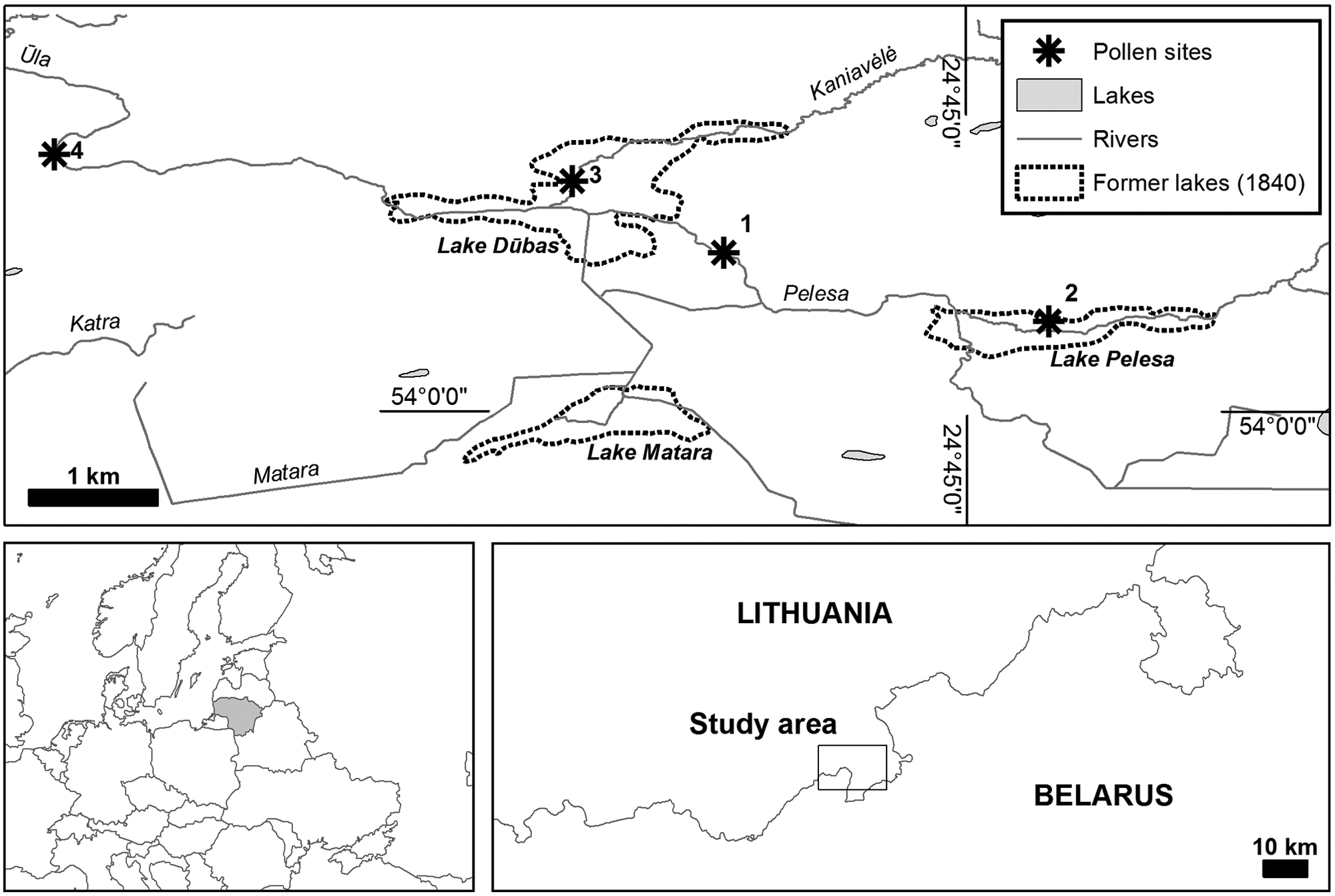
The study area. Investigated pollen sites: 1: Ūla outcrop; 2: Pelesa Lake (Stančikaitė et al., 2002); 3: Dūbas Lake (Stančikaitė et al., 2002); 4: Kriokšlys outcrop (Kabailienė et al., 2001). Former lake boundaries were determined from historical maps provided by R. Linkevičienė.
It is known from earlier investigations that between 12,800 and 11,500 cal. BP water levels dropped dramatically in the periglacial lakes of SE Lithuania because of low temperatures and low precipitation. Their waters were clear and cold, with low amounts of organic matter, and muddy sand or mud deposits prevailing (Švedas and Česnulevičius, 2009b). According to our investigations, this process took place somewhat earlier – at the end of the Lateglacial. At the beginning of the Holocene (Preboreal) average temperatures were c. 4°C lower than present, and precipitation was minor (Kabailienė, 1990). In the Preboreal and early Boreal lake water level was lowest throughout the Holocene (Švedas and Česnulevičius, 2009b). Then temperatures and precipitation increased – annual average temperature was close to that of the present. Despite increasing precipitation, dry conditions still prevailed – annual precipitation was approximately 550 mm. Rapid water flow (increasingly shallow conditions) and overgrowth was experienced during this period (Kabailienė et al., 1997; Tarasov et al., 1994). Water level was also low in Kolono Lake (Poland) at this time (Yu and Harrison, 1995). Our investigations show that already at the beginning of the Preboreal a large lake existed in the watershed of Ūla–Katra.
During the Lateglacial, intensive aeolian and bog formation processes occurred in the study area (Bitinas, 2004; Blažauskas et al., 1998). Aeolian processes had formed ridges of continental dunes, which later became river basin watersheds. The Čepkeliai raised bog started to form at higher areas of the watershed, as a result of humidity excess and poor drainage conditions. Later, either as a result of the eroded watershed between the Katra River upland and the investigated lake, or as a result of water balance change due to climate changes, a large part of the lake was drained or dried out. Three lakes of the smaller area (Dūbas, Pelesa and Matara), that remained in the deeper parts, degraded gradually throughout the Holocene because of natural and anthropogenic processes. It has been argued that this recent degradation of the remnant lakes was caused by river capture, which in turn could have natural, as well as anthropogenic causes (Linkevičienė, 2009). Nowadays dry meadows are found in the territory of the former lakes. More information on Holocene palaeogeography and palaeohydrology of the region was gained from multiproxy investigations (Gaigalas and Molodkov, 2002; Gaigalas et al., 2001; Kabailienė, 1998; Kabailienė et al., 1997; Mažeika et al., 2009; Stančikaitė et al., 2002).
Methods
Coring and sampling
Samples for pollen and lithological analyses as well as for conventional 14C dating were collected from the River Ūla outcrop (54°01′22″N, 24°42′57″E) situated 2 km west of Dubičiai village, between former lakes Dūbas, Pelesa and Matara. Sediments for pollen analysis were sampled at 5 cm intervals. Samples for radiocarbon dating were taken from the bottom-most organic layer at 2 cm intervals (167–165 cm, 165–163 cm depth) and the thin interlayer lying at a depth of 100–105 cm. Additionally, five samples, representing the uppermost part of the sandy peat, were taken from the test-pit situated 200 m southwestwards from the outcrop described above (54°01′16″N, 24°42′53″E, Figure 1). Here samples were collected every 2 cm from the 8–18 cm interval. Additionally, a tree fragment discovered at 18–19 cm depth was taken for isotope dating. Samples from the outcrop were also collected for loss-on-ignition measurements: 10–160 cm and 170–175 cm intervals were sampled every 5 cm, 161–169 cm interval was sampled every 2 cm.
Lithological analysis
To ascertain loss-on-ignition (LOI), sediments covering the 10–175 cm interval were investigated. Primarily, the samples were slowly dried at 50–80°C and later at 105°C until a constant weight was reached. Carbonate content was estimated by titration with HCl, organic matter content was estimated using loss of weight on ignition at 550°C, and the mineral (ash) component of the sediment matrix was calculated. The water content and dry bulk density of sediments were estimated by weighing standard volume samples dried at 105°C. Percentage of the main sedimentary components was estimated as described in Bengtsson and Enell (1986).
Lithological types of sediments were determined from grain-size analysis implemented by combined pipette and sieve (vibratory sieve apparatus FRISH and standard 16 sieve package) methods. The grain-size composition of soil fractions larger than 1.0 mm was determined by sieving using the dry method, fractions between 0.063 mm and 1.0 mm were determined by sieving, therefore they were rinsed through a 0.063 mm sieve, smaller fractions were collected into a separate jar. The grain-size composition of sediment fractions smaller than 0.063 mm was determined by the pipette method in cylinders (capacity of 1 l).
Radiocarbon dating
Conventional 14C dating was performed on eight bulk organic samples and one wood remnant sample that were mostly attributed to the intervals with the highest organic content in the sediment sequences of the Ūla River outcrop and the test pit. Samples were analyzed at the Radioisotope Research Laboratory of the Institute of Geology and Geography, Vilnius, Lithuania. After drying and physical pretreatment the samples were treated by acid-alkali-acid washing. The specific activity of 14C was measured by the liquid scintillation counting (LSC) method as described in Gupta and Polach (1985), Arslanov (1985) and Kovaliukh and Skripkin (1994).
The radiocarbon calibration program OxCal v3.10 (Bronk Ramsey, 2001) with the IntCal09 data set (Reimer et al., 2009) was used for the calibration of radiocarbon dates, estimation of sediment accumulation rate and geochronological assessment. Timescales were constructed on the basis of the linear interpolation between available dates, and all ages are given as calibrated years before
Pollen analysis
Pollen analysis was carried out at 10 cm or 5 cm intervals. Laboratory preparation followed heavy liquid and acetholysis procedures described by Grichiuk (1940) and Erdtman (1936). In order to determine pollen concentration, the volume of all samples was measured and a known number of Lycopodium marker spores added (Stockmarr, 1971). At least 500 terrestrial pollen grains were counted in each sample, except for the bottom sample from the Ūla outcrop, where an extremely low pollen concentration (444 grains/cm3) was observed. Pollen identification followed Moore et al. (1991) and reference collections of the Department of Geology and Mineralogy, Vilnius University. The results of the pollen analysis are presented as percentage pollen diagrams, created using TILIA and TILIA Graph software (Grimm, 1990, 1992). Samples were subdivided into local pollen assemblage zones (LPAZ) by visual inspection and results of stratigraphically constrained cluster analysis (Grimm, 1987).
GIS analysis
Geographic data processing and GIS analysis were carried out using ArcGIS software (v. 9.3.1). Elevation contours in the study area were digitized from scanned topographic maps (1980) of Lithuania (scale 1:10,000) and Belarus (scale 1:50,000). Digitized contours were used to interpolate the digital elevation model (DEM) of the study area according to the ANUDEM algorithm (Hutchinson, 1988, 1989). The created DEM was used for three-dimensional visualization of the territory and surface water level simulation.
Former water levels and lake boundaries were simulated according to the created DEM, a geological map of the area, archaeological site locations (Stančikaitė et al., 2002) and available coring data. Approximate sediment depth was subtracted from the present surface model to obtain DEMs, representing the beginning of the Lateglacial (approx. 15,000 cal. BP), onset of the Holocene (11,500 cal. BP), and early Holocene (9500 cal. BP). Subtraction of the sediment depth was necessary, since DEM changed in the area as sediments were constantly accumulating. As a result, new DEMs were produced for each investigated time window, representing elevations of that particular period.
Available coring and core analysis data were used as additional sources of information to verify the results achieved by other methods. Dated pollen and diatom diagrams from Dūbas and Pelesa lakes (Stančikaitė et al., 2002) provided information of the water depths at the known locations of Dūbas and Pelesa lakes. Although these data proposed only approximate estimations they were an important alternative source of information for verification of the determined water levels by geological or archaeological data.
Water level above sea level for the beginning of the Lateglacial was determined according to the geological map, considering that it should coincide with the margins between glacial and postglacial sediments. Therefore, it was assumed that the height of the water level at the beginning of the Lateglacial can be considered equal to the height of the water level at this time window.
Water level heights corresponding to the beginning of the Holocene and early Holocene were determined according to the known locations of the archaeological sites (considering that settlements were situated on the bank of the basin or higher) in conjunction with the analyzed sediment cores, in which dynamics of the lithological composition throughout the Holocene are known. Altitudes of archeological sites of the particular time window (Palaeolithic, Mesolithic, Neolithic, etc.) were evaluated, and the water level height was assumed to be equal to the lowest altitude of the selected archaeological sites of a particular chronological interval (excluding obvious outliers).
Raster cells in the corresponding DEM, where surface altitude is lower than the estimated water level for the particular time window, were exported to raster data sets, representing the lake surface at that time window (see Figure 5).
Results
Terrain of the study area
Elevation of the investigated territory ranges between 117.5 and 178.1 m a.s.l. The plain, stretching between Dūbas, Pelesa and Matara lakes, occupies most of the study area (Figure 2). Slopes rarely exceed 2–3° here. The lowest altitudes are observed in the area of the former lake Dūbas and in the source area of the Ūla River valley. The highest altitudes are distributed in the northeast of the territory, where landforms of the Middle Pleistocene Medininkai (Warthe) glaciation are widespread (Baltrūnas et al., 2007). Prior to 1840, the whole area was drained via the River Katra westward (Linkevičienė, 2009), and the direction of the abovementioned Ūla inlet was opposite to that of the present day. The terrain in the area between the present Katra and Ūla inlet upper reaches is rather flat (altitudes vary within 1 m at most parts of the territory), i.e. the area seems sensitive to hydrological changes. Furthermore, the elevation model shows that the watershed separating the basin from Katra River drainage path lies at 130 m a.s.l. Hence, it can be concluded that the basin would be drained through the Katra River if water level rose above 130 m a.s.l.
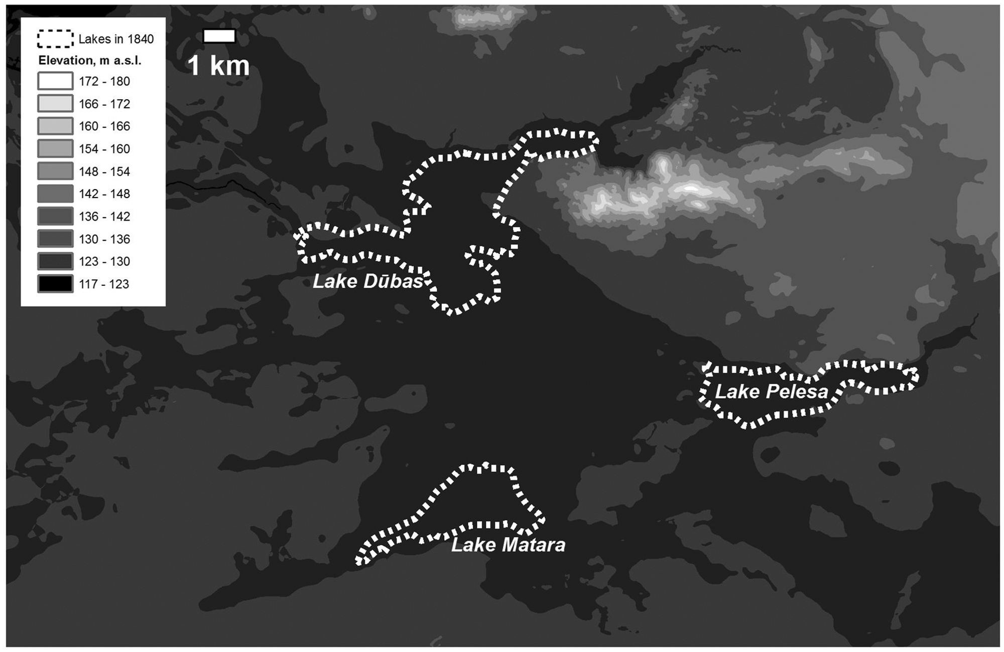
Surface elevation of the area.
Lithology
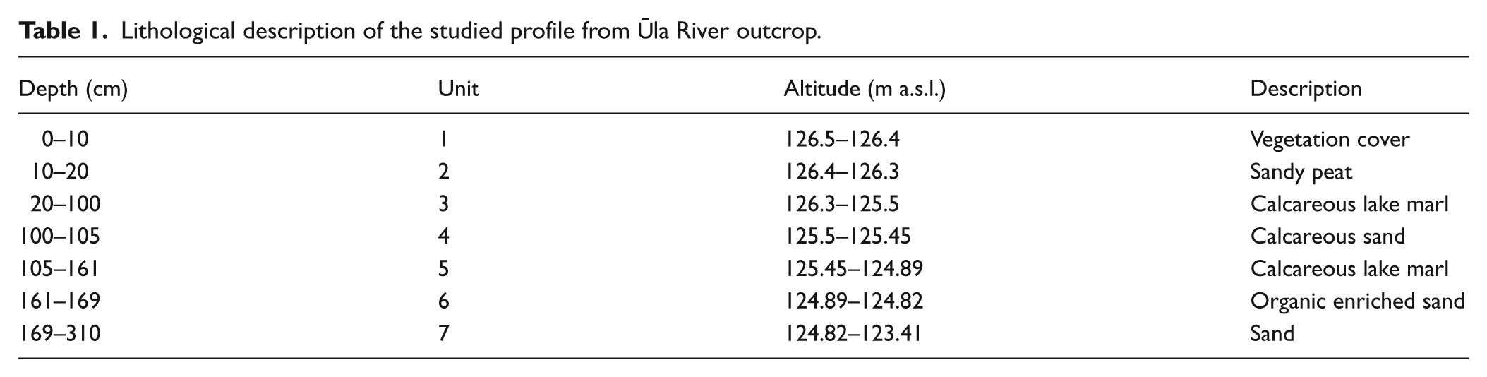
Following visual inspection, the sediment sequence from the Dubičiai outcrop was subdivided into seven lithological units (Table 1). The lithological composition reveals multiple stages in the development of the sedimentation basin. Sand layers that occur at the base of the outcrop (310–169 cm) confirm the intensive input of minerogenic material into the basin. Here, the amount of terrigenous matter reaches 99.5% according to LOI measurements (Table 2).
Lithological description of the studied profile from Ūla River outcrop.
Grain-size and component composition of the sediments (161–169 cm interval) from Ūla outcrop.
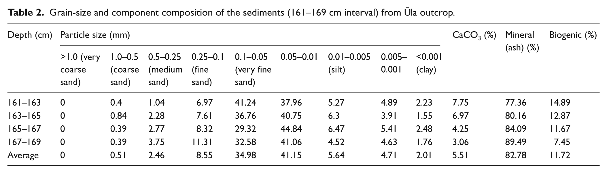
Formation of the overlying bed, i.e. organic-enriched sand (169–161 cm, Table 2) with an increasing organic constituent, suggests some stabilization of the environmental situation. The lowest amounts of organic-enriched sediments (7.45%), particles forming silt and clay (82.8%) and CaCO3 (1.71%), are recorded in the lower part of the layer (167–169 cm). The percentage of organic matter increases to 11.67%, while clay with silt constitutes 86% in the depth 165–167 cm. Above (163–165 cm) the amount of organic-enriched sediments, clay and silt is even higher. The percentage of CaCO3 increases even further, and some not fully decayed plant remains were found in this layer. Amounts of fine soil fractions, organic matter and CaCO3 are even higher in the depth 161–163 cm.
Distribution of the organic-enriched sediments underlying the lake marl is rather restricted in the area where layers of the above-mentioned lake marl are present. These formations are exposed only in two places along the Ūla River. The amount of organic matter in this layer is very close to that in the shallow littoral zone (> 1 m) of modern lakes (Linkevičienė et al., 2004). However, the amount of silt and clay in these lakes is lower (22% on average). A layer of organic-enriched sediments may have been deposited in the lake of thermokarstic origin. Judging from the increase in the amount of organic matter, silt, clay and carbonates, an assumption can be made that the water level of the lake was gradually increasing at the time of layer formation.
The organic-enriched sediments are overlain by 55 cm of calcareous lake marl (161–105 cm) where a calcareous constituent predominates, reaching 86.2%, while the minerogenic matter decreases sharply (to 7.9–15.3%). A small interlayer consisting of terrigenous particles (64.9%) with a high input of calcareous matter (up to 29.8%) was discovered at a depth of 100–105 cm, indicating increasing input of terrigenous matter to the basin. An increase in CaCO3 content (up to 89.4%) coincides with the lower limit of unit 3 (100 cm) where deposition of calcareous lake marl started. Organic material increased in the uppermost part of the profile (sandy peat, 10–20 cm), reaching 63.5%.
Chronology
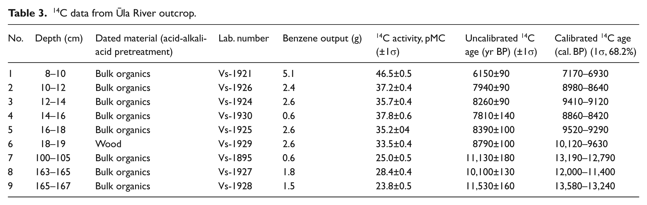
Radiocarbon dates and an age–depth plot from the investigated sequences are presented in Table 3 and Figure 3. The combined sediment sequence of the Ūla River outcrop and pit comprises a calibrated 14C age interval of 6930–13750 cal. BP.
14C data from Ūla River outcrop.
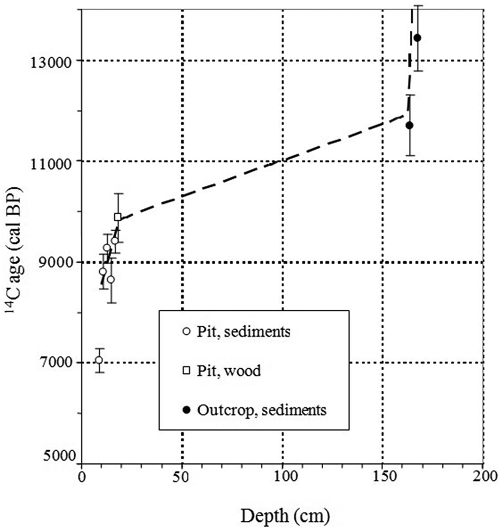
14C age (within 1 σ range)/depth plot for investigated sequences.
The oldest date obtained from the lower part of the Ūla River outcrop (167–165 cm depth) places the deposition of the investigated sediments from 13,580 cal. BP to 13,240 cal. BP (Vs-1928; Table 3), and that correlates with the Allerød Interstadial or the GI-1 event (13,900–12,600 cal. BP) (Björck et al., 1998; Walker et al., 1999; Wohlfarth et al., 1995). The next date (Vs-1927, 163–165 cm depth, Table 3) indicates deposition of the investigated material at about 12,000–11,400 cal. BP, i.e. during the Younger Dryas Stadial or GS-1 event in the North Atlantic region (Björck et al., 1998, 2002). This chronological information correlates well with palaeobotanical and lithological data suggesting scarcity of vegetation cover and a low representation of organic matter in the sediments, as well as predominance of the sandy habitats and intensive aeolian processes taking place in the area. A similar Lateglacial environmental pattern was recorded in the region earlier (Blažauskas et al., 1998; Stančikaitė et al., 2002).
After 11,400 cal. BP, deposition of the calcareous lake marl (161–20 cm depth) began in the basin. Formation of this bed continued until about 9520–9290 cal. BP (16–18 cm depth, Vs-1925) when sandy peat started to accumulate. Changes in the environmental situation may have caused the deposition of calcareous sand recorded at a depth of 105–100 cm. Unfortunately, the indicated age of these sediments (13,190–12,790 cal. BP) shows remarkable dating reversal, and, because of this inconsistency, this dating was excluded from the age–depth model.
The uppermost part of the investigated profile was deposited between 11,400 and 6930 cal. BP (Table 3), suggesting a Holocene age of the investigated strata. The dating reversal, occurring in the upper part of the profile (Vs-1930, Table 3), may have resulted from the moving or reworking of the sediments by human interference, as the area of intensive agriculture stretches around the investigation plot. Furthermore, contamination of the investigated layer by roots as well as infiltration by ‘modern’ water can not be rejected. For this reason, the application of the above-mentioned date for the construction of the age–depth curve is limited.
Palynological results
The pollen data have been described in terms of local pollen assemblage zones (LPAZ) based on the visual and statistical evaluations of the pollen spectra. Six LPAZ were established for the Ūla River outcrop diagram (Figure 4; Table 4).
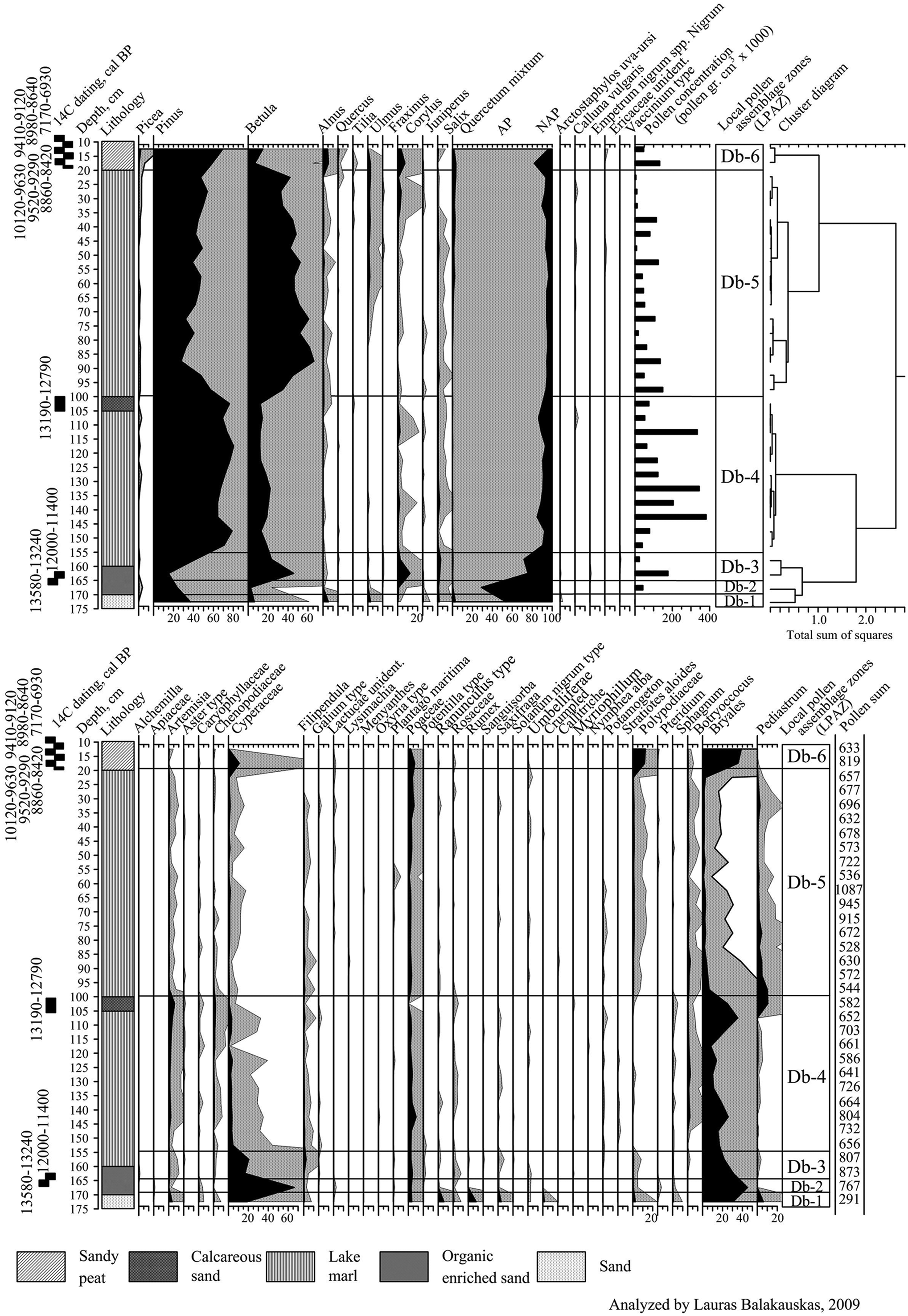
Pollen percentage diagram of the Ūla River outcrop.
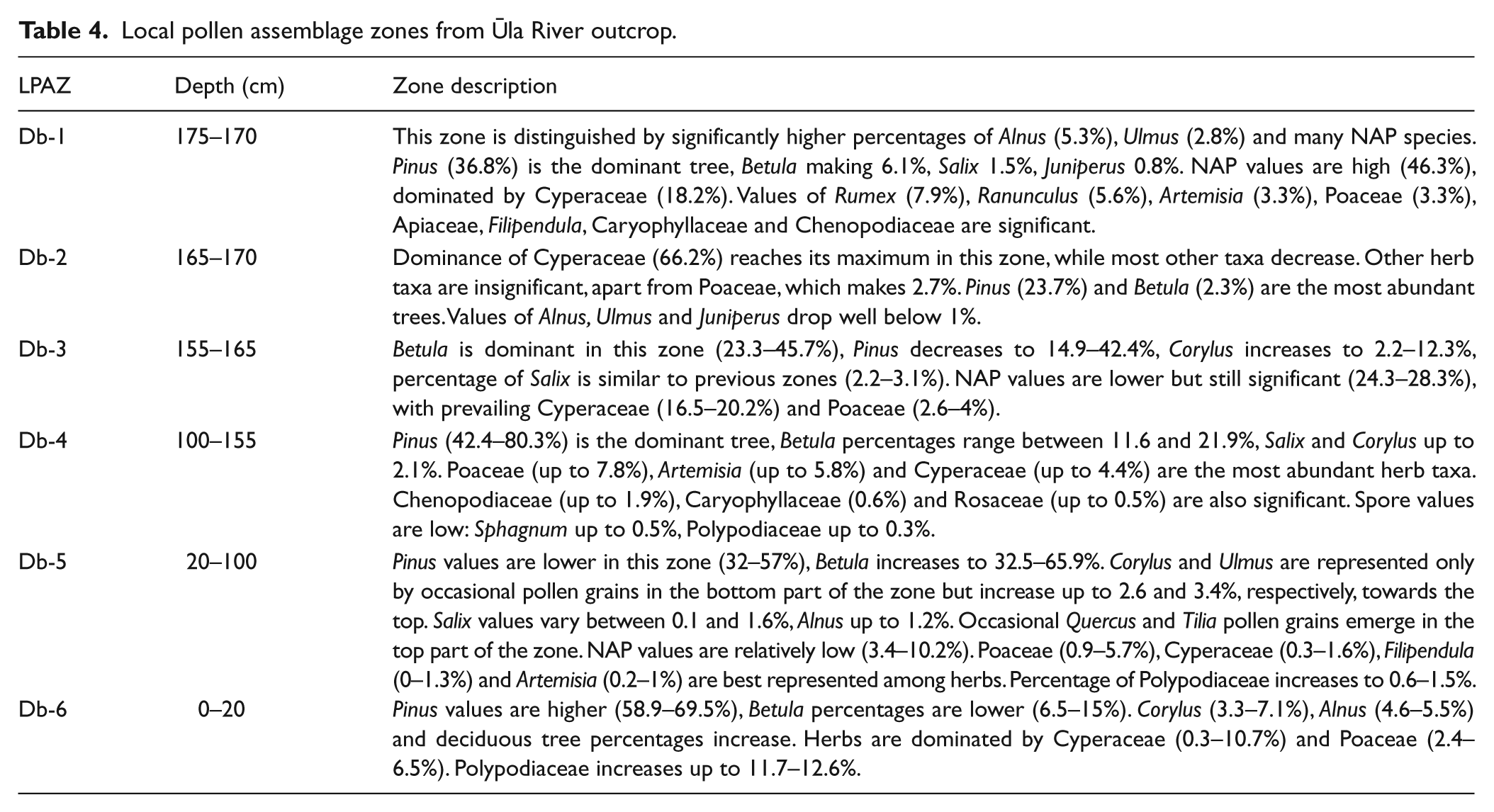
Local pollen assemblage zones from Ūla River outcrop.
Discussion
Multiproxy studies carried out on sediments of lakes Dūbas and Pelesa showed that these lakes formed a single basin during the Lateglacial, and were separated in the early Holocene by a drop in the water level (Stančikaitė et al., 2002). The reconstruction of the area’s development shown provides information on the Lateglacial and Holocene environmental history in southeastern Lithuania, a territory situated in a marginal area of the Late Weichselian Glaciation.
Formations of Medininkai (Warthe) glaciation (up to 170 m a.s.l.), dominating the northwest of the study area (Guobytė, 2004), were situated in the periglacial zone during the last glaciation. Following the Lateglacial (Weichselian) maximum, named the Grūda Stage, in Lithuania two glacial limits of ice advance, i.e. Žiogeliai Phase and the Baltija Stage, were recorded in the investigated area (Baltrūnas and Pukelytė, 2001; Gaigalas et al., 2001). Recent investigations revealed no evidence of a geological section in the southeastern flank of the Scandinavian Ice Sheet, with deposits between two tills of the last glaciation providing evidence for a climatic oscillation (Bitinas, 2012). In any case, the impact of the Late Weichselian Glacial on the surface history, structure and palaeohydrology of the investigated area was remarkable (Baltrūnas et al., 2007; Basalykas, 1965). During the final intervals of the Grūda Stage, meltwater gave rise to lakes between the melting ice sheet and moraine hills of Middle Pleistocene age. In the investigated area, altitude of this periglacial lake was around 140 m a.s.l., and it lowered to 130–128 m a.s.l. when the ice cover started to retreat (Baltrūnas et al., 2007). Laminated clay, now seen at the lower reaches of the Katra River, most probably accumulated in this basin during the discussed period. The next stage in the development of the area was related to the retreat of the Žiogeliai ice front, when the depositional activity of the meltwater in the marginal zone switched to erosion (Baltrūnas et al., 2007). Nevertheless, these fluctuations had a minor influence upon the environment of the study area, where glaciolimnic basins continued to exist. Even though the retreat of the glacier at the Baltija Stage of the last glaciation repeatedly caused increasing glaciofluvial sedimentation in the southeastern part of the Lithuanian territory (Blažauskas et al., 2007), glaciolimnic basins still survived in the area (Baltrūnas et al., 2007).
It seems that this basin, lying at about 130–128 m a.s.l. (Figure 5a), existed until the Allerød Interstadial when, according to diatom studies of lakes Dūbas and Pelesa (Stančikaitė et al., 2002), a considerable lowering of water level, predetermined by intensive erosion, took place in the area. Water drainage most likely followed southwestwards via the Katra River. According to freshwater discharge modeling, the freshwater discharge to the North Atlantic increased at about 13,300 BP (Obbink et al., 2010). At that time gyttja was deposited in the deepest parts of Dūbas and Pelesa, whereas organic-enriched sand (lying at about 124.85 m a.s.l. and dating back to 13,580–11,400 cal. BP) accumulated in the area of the investigated outcrop. High input of minerogenous particles (77–89% in the corresponding layer) into the basin may have been determined by aeolian activity, which in the study area began near the end of the Allerød (Blažauskas et al., 1998). According to the results obtained, the main basin was subdivided into three separate lakes during this period (Figure 5b), while in the area between these lakes thermokarst processes were active and smaller water basins occurred. Unfortunately, only two pollen samples represent this sediment layer (organic-enriched sand) in the pollen sequence. The lower pollen assemblage (167.5 cm depth) is dominated by open-landscape taxa (mainly Cyperaceae), which is not common for the Allerød chronozone in Lithuania (Kabailienė, 1990, 2006) and probably represents the end of the Older Dryas chronozone. No typical Allerød assemblages are evident in the pollen diagram, which is probably due to terrestrial conditions prevailing in the investigated site. A relatively high amount of Betula pollen and a decrease in NAP at 162.5 cm depth can be correlated with the Preboral chronozone (Kabailienė, 1990). Similar instability of the environmental situation, including changes in the water-table and vegetation composition, dated back to about 13,100–13,000 cal. BP was recorded in other parts of Lithuanian territory (Stančikaitė et al., 2008, 2009).
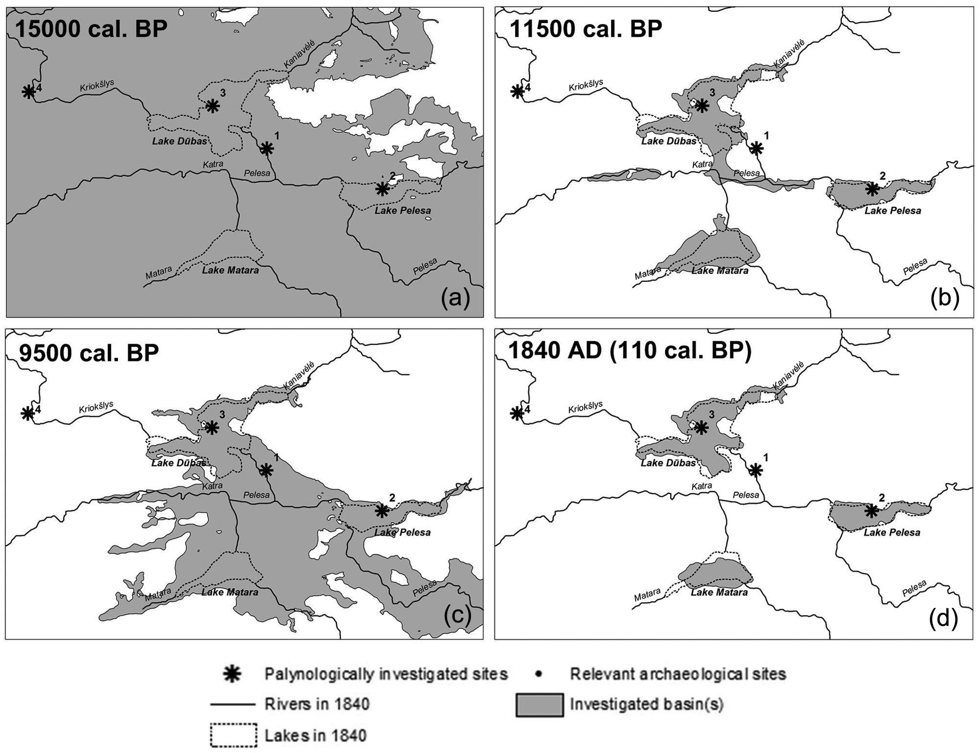
Simulated water levels at 15,000 cal. BP (a); 11,500 cal. BP (b); 9500 cal. BP (c); and ones digitized from
In the study area, low water-table levels continued throughout the final stage of the Lateglacial, i.e. Younger Dryas Stadial (Stančikaitė et al., 2002). A similar pattern was recorded in the numerous lakes within Lithuania (Stančikaitė et al., 2009) and abroad (Björck et al., 1998; Walker et al., 1999). Furthermore, because of the globally important climatic deterioration (Björck et al., 1996; Schwander et al., 2000), density of the vegetation cover decreased considerably and aeolian processes developed in the southeastern part of the country. Composition of the vegetation cover suggests predominance of open tundra-like vegetation, with high representation of xerophytic taxa. LOI measurements showed a high proportion of terrigenous material in the investigated section. Numerous lakes that existed at the time in this region were filled by aeolian sand (Bitinas, 2004; Blažauskas et al., 1998; Seibutis, 1974).
Approaching the end of the Younger Dryas, water level should have corresponded to approximately 125–126 m a.s.l. in the basin (Figure 5b). Water level has been reconstructed according to the observed sediments and positions of Palaeolithic archaeological sites (Rimantienė, 1971; Stančikaitė et al., 2002). Numerous archaeological sites attributed to Vilnius and Swiderian cultural groups (Rimantienė, 1971) were discovered lying at this or higher altitudes. It can be assumed that the mentioned archaeological sites were situated in the immediate vicinity of the lake shores.
During the Preboreal, water level reached the lowest point of the entire Holocene in the lakes of Lithuania (Kabailienė, 1990). Water level also was lowered in the investigated lake. Diatom content in Dūbas and Pelesa lakes decreased significantly (Stančikaitė et al., 2002), while peat started to accumulate at nearby Čepkeliai bog (10,550–9700 cal. BP; Mažeika et al., 2009).
During the first part of the Boreal, before 9290–9520 cal. BP, the water-table rose dramatically (up to approximately 130 m, as can be estimated from the positions of archaeological sites (Rimantienė, 1971; Figure 5c)), and calcareous lake marl started to accumulate in the investigated site. This substantial rise in water level could have been caused by blocking of the drainage via the present Katra path, possibly as a result of the formation of aeolian dunes. Ombrotrophic peat, lying below mesotrophic peat in the area of Dūbas, Pelesa and Matara palaeolakes, could not have formed in the area influenced by the river network. The absence of the river network at this stage kept the water-table high for several centuries. Subsequently a 1.4 m layer of calcareous lake marl accumulated in the area of Ūla outcrop. Vegetation around the investigated site was dominated by pine and birch forest, with small percentages of elm, hazel and oak appearing towards the end of the time interval. Such conditions are synchronous to other areas of Lithuania (Kabailienė, 1990, 2006) and earlier pollen investigations in the study area (Stančikaitė et al., 2002).
As a result of river network formation, the lake was drained once again at 9520–9290 cal. BP. Water level dropped significantly and sandy peat started to accumulate at the Ūla outcrop site, which was above the water-table at the time. Lakes Dūbas, Pelesa and Matara were isolated from each other. Dating and sediment analysis data show this change as being rather abrupt. Possibly it was caused by river capture, similar to the one that took place in the same area in the 1830s (Linkevičienė, 2009).
For the rest of the Holocene (until the 1830s; Figure 5d) water levels remained relatively stable. Late Mesolithic and Neolithic archaeological sites are situated close to the sites of the early Mesolithic (Rimantienė, 1971; Stančikaitė et al., 2002) suggesting a stable environmental regime in the area, although some minor water level fluctuations are suggested by the results of the diatom survey (Stančikaitė et al., 2002). Historical data (Linkevičienė, 2009) show eventual water level decrease to approximately 127 m a.s.l. towards
Conclusions
During the Lateglacial and the Holocene, drainage conditions changed numerous times in the area of lakes Dūbas, Pelesa and Matara, including occurrences of river capture in prehistoric as well as recent times.
The majority of the present-day landscape and nature of the surface sediments in the study area were determined by a large water basin covering most of the area after the retreat of continental ice-sheet from southeastern Lithuania.
During the Allerød Interstadial, water level dropped because of climate change, and the basin of Dūbas, Pelesa and Matara was subdivided into separate lakes. Formation of the small lakes was driven by thermokarstic processes occurring in the study area at that time. The area between three main lakes remained free of water until the beginning of the Holocene.
After 12,000–11,400 cal. BP (most likely in the early Boreal), the water drainage path was blocked by aeolian sediments, which caused a significant rise in the water-table. Owing to the rise in water level, previously separated lakes were repeatedly joined into one large basin.
This situation was not long-lasting – at 9520–9290 cal. BP lake water was abruptly drained, thus significantly lowering water level and forming separate lakes, similar to those known from historical data. Such an abrupt hydrological change could have been caused by river capture. In the study area less significant fluctuations continued up to a recent case of river capture recorded in the historical data of the 19th century.
Our study has complemented knowledge of Lateglacial and Holocene hydrological changes as well as their causes in the marginal area of the last glaciation. Alongside the climate changes that caused the filling up of water basins in the study area, the hydrological conditions in the Ūla–Katra watershed were influenced by the river network, as well as by the impact of aeolian processes, which is evidenced by blocking the former Ūla upper reaches. Possibly, blocking of the River Ūla caused the formation of the large basin in the Preboreal, even though lake depth and area decreased in the surrounding territories during this period. Later, when climatic moisture increased during particular periods, intensive river network reformation took place, led by the erosion of the river valley and capture phenomena.
Present changes of drainage conditions can be considered to be caused by human impact, however, it can be argued that simultaneusly drainage is determined by natural causes, i.e. continuous formation of the river network in the Ūla catchment area. Reconstructed development of former Dūbas, Pelesa and Matara lakes as well as their extinction shows the particular sensitivity of the study area to hydrological changes and the dramatic significance of these hydrological changes to the environment of the surroundings.
To date, sustainable wetland management relied on the premise that climate change and altered hydrological conditions of the surroundings by humans are the main factors influencing degradation of ombogenous mires. Owing to the increasing temperature and precipitation changes water supplies in ombogenous mires decrease and summer water deficit emerges. This effect is further reinforced by reclamation of bogs and their surroundings. The present study has shown that ombogenous bog degradation can also emerge because of natural changes in the river network. Hydrological conditions of the investigated territories and Čepkeliai mire Ramsar site have changed from periglacial lake to wetland complex during the Lateglacial and the Holocene. Later, after formation of the river network, as drainage of the investigated area significantly improved, mire degradation began. Because of erosion deepening river beds, degradation takes place even today. Present management of the investigated area is based on limiting anthropogenic activity and is rather related to the territory of the Čepkeliai mire. Present study shows that limiting human activity is not sufficient to suppress mire degradation and it can only be achieved by artificially sustaining river bed morphometric characteristics in the vicinity.
Footnotes
Funding
This study was financed by the Research Council of Lithuania (No. LEK-02/2010).