



Abstract
Despite many studies of Holocene paleoclimate records from small lakes in the mid-continent of North America, direct estimates of lake-level changes associated with mid-Holocene aridity are rare. Varved sediments from Elk Lake, Clearwater County, Minnesota, are among the best studied in terms of paleoenvironmental proxies, yet the sedimentary architecture of those sediments has not been previously studied and the hydrological responses of the lake – changes in level and volume – are poorly known. High-resolution seismic-reflection (CHIRP) profiles of Elk Lake reveal complex sedimentary basins in the lake, a pattern of nearshore onlap of sediments onto older substrates, and the focusing of sediments into several deep basins. Biogenic gas obscures sediments in the deepest parts of the basins, but beneath the rest of the lake, a three-part Holocene sequence is clear. The transitions between these parts are correlated with lithological changes defined in earlier core studies. Sediments of the modern stage are less focused than those of the prairie lake stage. A prominent erosional unconformity occurs within the Holocene sequence, separating sediments from the prairie and modern stages of the lake. Erosion associated with this unconformity extends to a depth of 18.2 m below the modern water surface, at which point the unconformity grades into a conformable horizon within the sequence in the deep basins of the lake. This transition is an analog of the onlap of modern sediments onto older substrates, which occurs at a depth of about 8.2 m. The configuration of the erosional unconformity and its modern analog indicates a lake-level fall in the mid Holocene of 10.0 m. At its mid-Holocene minimum, the lake was 39% of its present size and 30% of its present volume, providing quantitative evidence to aid in constraining and evaluating reconstructions of mid-Holocene aridity in the mid-continent of North America.
Introduction
Elk Lake, Minnesota (Figure 1), is an iconic site for Holocene paleoclimate reconstruction in terrestrial environments. The varved sediments of the lake have been studied for decades as a source of paleoenvironmental proxies and paleoclimatic inferences. A major compilation of research related to the history of the lake included comprehensive studies of limnology, sedimentology, and paleontology (Bradbury et al., 1993). Most of that work was developed from study of a 22.5 m composite sequence from piston coring in the deepest part of the lake (Anderson et al., 1993), along with ancillary bottom-sediment and sediment-trap data. Despite this research, relatively little is known about overall sedimentary architecture of the lake basin. Even the bathymetry of the lake is only crudely known, apparently from scattered soundings and some echosounder data (Megard et al., 1993). To our knowledge, no sub-bottom seismic-reflection survey of the lake basin and its sediments has been previously conducted.

Location maps of Elk Lake, Clearwater County, Minnesota. (a–c) Maps modified from figure 1 of Dean (1997) showing vegetation zones in Minnesota (a), location of Itasca State Park and Elk Lake (b), and bathymetry of Elk Lake (c). (d) Track line map showing location of seismic-reflection (CHIRP) profiles obtained in Elk Lake; heavy labeled lines indicate the location of profiles shown in Figures 3–5. Numbers on axes are in meters, Universal Transverse Mercator zone 15.
The Elk Lake paleoclimate record for the Holocene is one of many in north-central North America (e.g. COHMAP Members, 1988; Shuman et al., 2002; Williams et al., 2009). Most of these records agree that the middle Holocene was relatively warm and dry between roughly 8000 and 4000 years ago. However, details of this interval vary with the reconstruction methods used, and the timing of its onset, termination, and internal events remain uncertain. The magnitude of related changes in lake level are not well known. They have been estimated in some cases from the sedimentology of nearshore cores (Digerfeldt et al., 1992; Locke and Schwalb, 1997; Winkler et al., 1986) or from hydrologic models tied to various environmental proxies (e.g. Schwalb and Dean, 2002; Smith et al., 2002).
In this paper, we describe the results of a high-resolution seismic-reflection (CHIRP) survey of Elk Lake, Clearwater County, Minnesota (Figure 1d). The data allow us to outline the basic sedimentation patterns in the lake and their relation to bathymetry. In addition, we document a major unconformity in the Holocene section, discuss its relation to paleoenvironmental reconstructions from cores in the lake, and describe its implications for mid-Holocene drought in the upper Midwest. Specifically, we quantify the change in lake level associated with mid-Holocene dry conditions.
Methods
Seismic-reflection data were collected with an Edgetech™ CHIRP (Compressed High Intensity Radar Pulse) sub-bottom system, consisting of a 3100P deck unit and a SB-424 fish. The CHIRP data were collected along about 14 km of survey lines (Figure 1d) and were recorded in digital SEGY format using Edgetech™ Discover software. The CHIRP swept frequency range was 4–20 kHz in a pulse length of 10 ms. Average survey speed was about 5 km/h. Navigation coordinates were obtained by a hand-held Garmin™ GPS unit and were recorded with each recorded pulse in the SEGY files. Interpretation of the data and mapping of units were accomplished using SMT Kingdom™ Suite software.
The survey was conducted in August 2009, when the lake was at an elevation of 448.0 m. The towfish (zero on the time axis of the seismic profiles) was suspended about 0.5 m below the lake surface. For safety and data-quality reasons, the survey mostly was restricted to water depths greater than about 2 m. The depths and thicknesses discussed in this paper assume a speed of sound in water of 1440 m/s, a typical value for relatively dilute water bodies such Elk Lake (Megard et al., 1993), and slightly slower than the sound velocity in sea water (1500 m/s).
Results
Elk Lake, a kettle lake within the Itasca moraine in Minnesota, is characterized by complex tunnel-valley and collapse-basin topography (Wright, 1993). Previous depictions of the bathymetry of the lake (e.g. Figure 1c; Megard et al., 1993) were apparently based on scattered soundings compiled by Minnesota Department of Natural Resources (http://files.dnr.state.mn.us/lakefind/data/lakemaps/c1662011.pdf). The bathymetry of the lake derived from our seismic-reflection data (Figure 2a) is generally consistent with the previous bathymetric data. The overall lake basin is complex, with several sub-basins, the deepest and most prominent of which is toward the southeast end (Figure 2a).
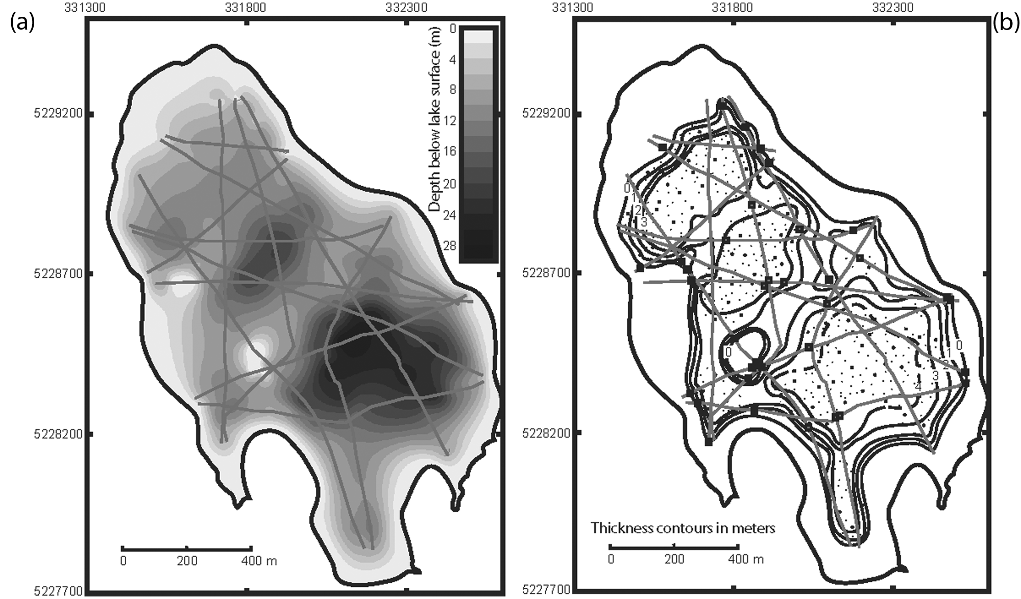
(a) Bathymetric map of Elk Lake based on CHIRP profile measurements. Depth values (scale in m) were calculated using a sound velocity in fresh water of 1440 m/s, and a 0.5 m correction for the depth of the CHIRP fish was applied. Compare with Figure 1(c). (b) Thickness of upper seismic unit (contours in m). This unit is correlated with the portion of the core that represents the ‘modern lake’ stage of Anderson (1993). Stippling indicates areas with abundant biogenic gas in the sediments; sediment thicknesses in these areas are minima. Solid squares indicate locations where the modern sediment onlap was observed and where its depth was measured; open squares indicate locations where the mid-Holocene unconformity grades into a conformable surface and where the depth to this transition was estimated.
In shallow water, aquatic macrophytes are commonly observed in the CHIRP profiles (Figure 3). In somewhat deeper water, a pre-existing surface at the lake floor makes for a strong reflection, which is onlapped by modern lake sediments in about 8 m (8.2 ± 0.7 n=25) of water (Figure 3). The lack of deposition above the point of onlap is due to resuspension of sediments by waves and currents in shallow water, and the point of onlap is commonly taken as the average depth to which oscillatory waves and related currents affect the lake floor. In Elk Lake, the depth of onlap of modern lake sediments is remarkably uniform spatially considering that wave energy is controlled by prevailing wind: it exhibits no systematic variation around the lake, averaging 8.2 ± 0.7 m (n=25) deep. Lake sediments gradually thicken toward the sedimentary basins in the lake (Figure 2b); sediment resuspension due to wave action in shallow water and a variety of other processes lead to such sediment focusing in deeper basins (Davis and Ford, 1982; Hilton, 1985). Changes in sedimentary unit thicknesses over relatively short distances in Elk Lake (Rush, 2010) clearly is due mostly to sediment focusing.
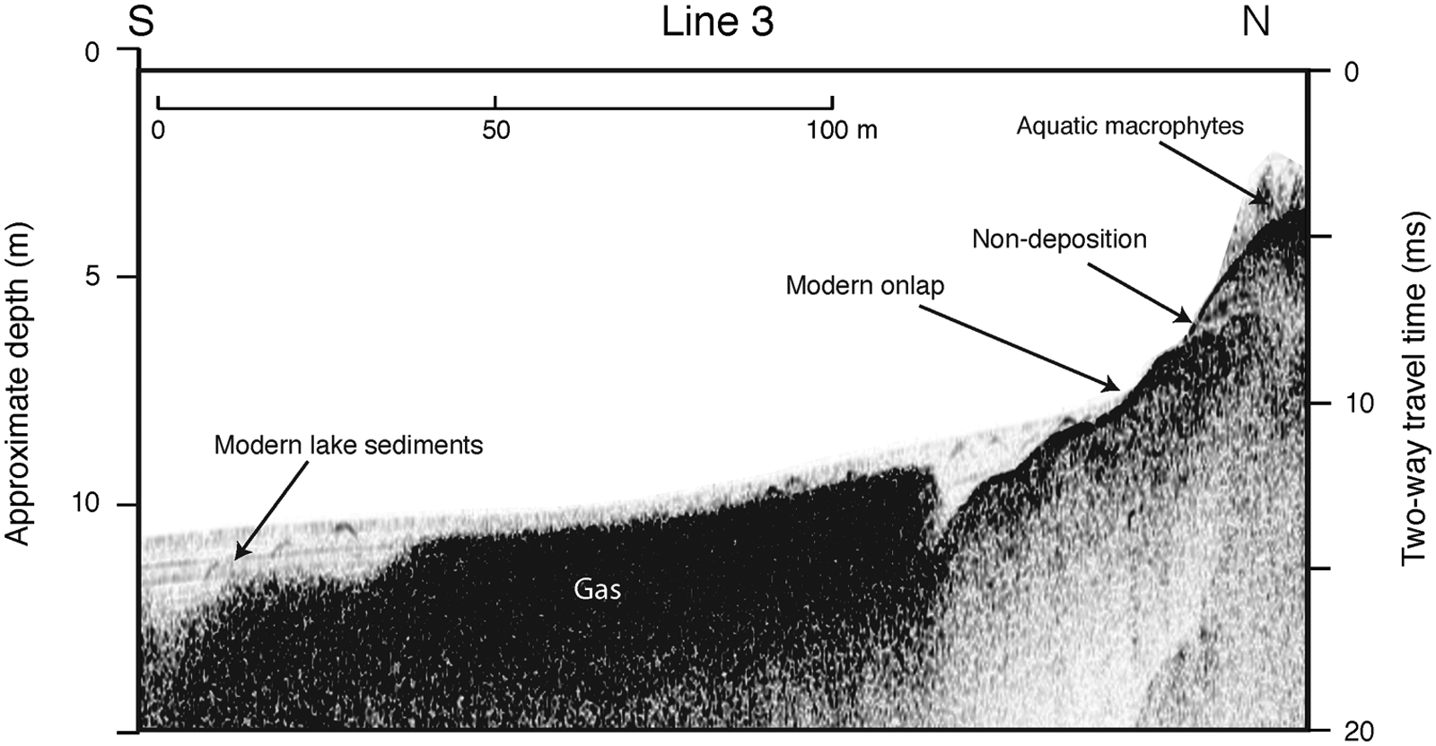
A section of CHIRP line 3, showing zonation of near-shore lake-floor features. Location shown in Figure 1. Depth scale assumes a sound velocity of 1440 m/s and includes a correction for the depth (0.5 m) of the CHIRP fish.
Where the uppermost lake sediments become relatively thick, they commonly are obscured in CHIRP profiles by diffuse, high-amplitude reflections characteristic of free gas in the sediments (Figures 2b, 3). In relatively productive lakes such as Elk Lake, which accumulate significant amounts of organic carbon (~2–9%) in the sediments (Dean, 1993), biogenic gas, primarily methane, is produced by anaerobic respiration. Even minor amounts of free gas bubbles scatter the acoustic signals, producing hazy, incoherent reflections (Figures 3–5).
Profiles across the depositional basins of the lake show that all of the sub-basins, where the thickest lake sediments have accumulated, contain abundant gas (Figures 2b, 4). However, the majority of the lake, including extensive areas on the sub-basin margins and several shelf-like areas between basins, display a clear stratigraphy of lacustrine sediments, characterized by moderate to strong, parallel internal reflections.
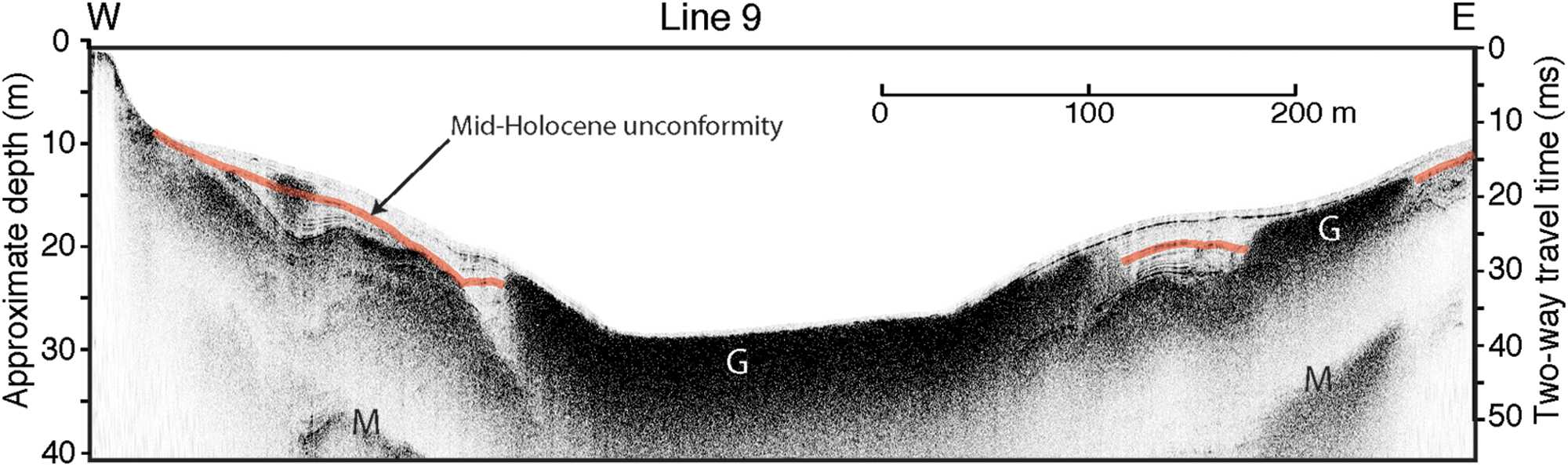
A section of CHIRP line 9, showing overview of southeastern basin of Elk Lake. Location shown in Figure 1. G: biogenic gas; M: multiple reflection (echo). Depth scale assumes a sound velocity of 1440 m/s and includes a correction for the depth (0.5 m) of the CHIRP fish.
From core data, the general stratigraphy of the sediment fill in Elk lake has been divided into three parts, and these three units have been inferred to thin toward the edges of the deep hole in the southeast part of the lake (Anderson, 1993). The three units were described as sediments of a ‘postglacial lake’, a ‘prairie lake’, and the ‘modern lake’. Independently, we have classified the seismic-reflection signatures of the sediment fill in the lake into three seismic-reflection units, on the basis of their acoustic properties in the CHIRP data, including their internal character, bounding surfaces or unconformities, and relationships to adjacent units (Figures 4, 5). Neither the original Elk Lake cores (Anderson et al., 1993) nor recent cores taken in conjunction with this study (Rush, 2010) can be unequivocally compared with the seismic-reflection profiles, because the cores come from the deep part of the southeastern basin where seismic reflections are obscured by gas in the sediments. Nevertheless, the three-part sequence of seismic-reflection units is consistent with the three-part core sediment sequence of Anderson (1993). Projection of the increasing thicknesses of the seismic-reflection units from the margins to the center of the depositional basin also supports the correlation of the three seismic-reflection units with the three core units, although such projections have large uncertainties.
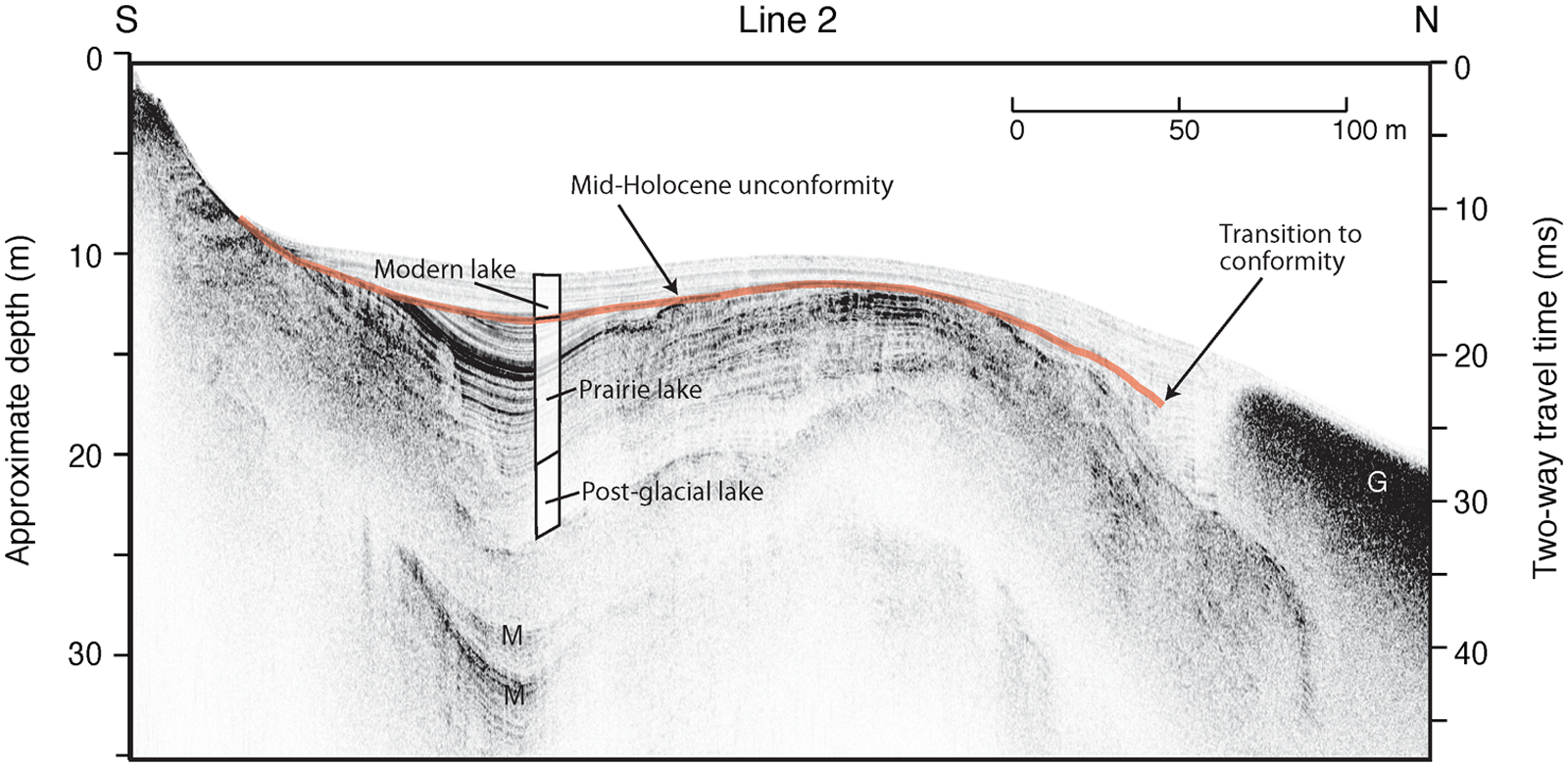
A section of CHIRP line 2, showing seismic-stratigraphic units and mid-Holocene unconformity. The three seismic-stratigraphic units, defined by their seismic properties, are correlated with the core units related to the postglacial, prairie, and modern lake stages of Anderson (1993). Projections of the thicknesses of the seismic-stratigraphic units into the depositional basin are consistent with this correlation, but the seismic units and the core units cannot be directly linked. The thick, semi-transparent line indicates mid-Holocene unconformity; G: biogenic gas; M: multiple reflection (echo). Location shown in Figure 1. Depth scale assumes a sound velocity of 1440 m/s and includes a correction for the depth (0.5 m) of the CHIRP fish.
The three-part core sequence of Anderson (1993) is partly based on chemical and lithological changes of the kind that result in prominent seismic reflections. For example, the change from the prairie lake stage to the modern lake was marked by an abrupt change in varve character and decrease in thickness variability (Anderson, 1993). The three stages are also distinct in terms of quartz, aluminum, manganese, and other constituents (Dean, 1993). The prairie stage, marked by several indicators of aridity and eolian sedimentation, is especially distinctive lithologically (Bradbury et al., 1993). In addition to the changes in lithology that mark the three lake stages, lowering of lake level during the prairie lake stage would likely produce bounding seismic reflections.
Perhaps the most prominent feature of the Holocene lake-sediment sequence is a distinct erosional unconformity within the section (Figure 5). This unconformity forms a surface that separates the seismic units correlated with the prairie lake and the modern lake, and is thus roughly mid-Holocene in age. Significant erosional truncation of the prairie-lake unit occurs around the margins of the depositional basins, but the surface becomes conformable in the deeper parts of the basins (Figure 5). The transition between the unconformable and conformable nature of this surface is not evident on all profiles, but where observed, it occurs at a present water depth of 18.2 ± 1.1 m (n=12) (Figures 4 and 5). This conformity/unconformity transition is an analog of the modern onlap of lake sediments onto older substrates (Figures 3–5).
Discussion
The Holocene unconformity in Elk Lake is primary evidence for a mid-Holocene lake-level stand considerably lower than the present. One of the principles of lacustrine sedimentology is that, as lake level changes, the distribution of depositional zones in the nearshore shifts laterally as well as vertically, leaving behind a record of lake-level change. Accordingly, the distribution and character, or facies, of the resulting nearshore sediments record lake-level changes. Indeed, pioneering work using sediment cores in this way has produced estimated mid-Holocene lake-level falls of several meters in Minnesota (Digerfeldt et al., 1992; Locke and Schwalb, 1997; Winkler et al., 1986). Transects of cores have also been combined with remote imaging to estimate lake-level changes (e.g. Shuman et al., 2009). However, estimates based on detailed seismic-reflection surveys are rare.
One critical point in such facies analyses is the point (depth) below which sediments continuously accumulate. This point is approximately the average depth above which waves resuspend sediments and erode the substrate, and below which sediments are deposited. In the modern Elk Lake, this point is where modern sediments onlap onto older materials (Figure 3). The analogous point for the mid Holocene is the point above which older sediments were eroded, creating the lowstand unconformity. The unconformity itself is an erosion surface analogous to modern nearshore areas above the point of onlap of modern sediments. The point at which the unconformity grades into a conformable surface in the deeper part of the basins, which is also the landward limit of continuous deposition, is analogous to the point of onlap of modern sediments onto older substrates, or the landward limit of modern deposition (Figure 5). The difference in depth between these two locations, the modern onlap of sediments and the mid-Holocene unconformable–conformable transition, primarily is due to a change in lake level. Assuming that wave energy and other variables have not changed dramatically, then the difference in depth is also approximately equal to the change in lake level. In Elk Lake, the difference is 18.2 ± 1.1 m (mid-Holocene) to 8.2 ± 0.7 m (modern), or 10.0 ± 1.8 m.
Two competing factors may have changed the amount of wave energy between the mid Holocene and the present. First, the mid Holocene has been inferred to be windier than present (Dean, 1997; Dean et al., 1996), which would have increased wave energy. Increased windiness is consistent with the greater degree of sediment focusing that is evident in the pre-unconformity (prairie lake) section of the seismic profiles compared with the post-unconformity (modern lake) section (Figures 2b, 4, 5). Second, with lake level lower, the surface area and fetch of the lake would have been smaller, which would have decreased wave energy. To the degree that these and other factors offset each other, our simple subtraction is an accurate estimate of the change in lake level. Based on the modern hypsometry data of Megard et al. (1993), the 10-m-lower mid-Holocene lake would have been 39% of its modern size and 30% of its modern volume. Since the lowstand, the lake has not filled in (by sedimentation) by more than 1 m or so, except in the deepest basins, so these values are thought to be good estimates. They have the potential for direct use in hydrological models.
The Holocene paleoclimate history of central North America has been the subject of numerous studies, amongst which are the multidisciplinary studies of Elk Lake (Bradbury et al., 1993), as well as several syntheses (COHMAP Members, 1988; Dean et al., 2002; Hu et al., 1999; Williams et al., 2010). There is broad consensus that the mid Holocene, roughly 4–8 ka, was a relatively warm, dry period. Details are somewhat less certain, however, owing to different interpretations of various proxies, the time-transgressive nature of some of the climate changes, and uncertainties in chronologies. The Elk Lake record itself suggests that the period from 8 to 4 ka was one of general aridity (Bradbury et al., 1993), characterized by prairie rather than forest vegetation (Whitlock et al., 1993; Williams et al., 2009). Paleolimnological data (Bradbury and Dieterich-Rurup, 1993; Forester et al., 1987) and geochemical analyses (Dean, 1993) suggest that the lowest lake levels and most alkaline conditions at Elk Lake existed between about 7.2 and 6.8 ka. Additional work has suggested that the upper Midwest underwent several relatively rapid changes in atmospheric circulation, especially at about 8.2 ka (Dean et al., 2002; Hu et al., 1999; Williams et al., 2009), a time when most Northern Hemisphere records indicate a brief, abrupt cold spell. Although these studies identified the character and estimated the timing of this arid phase, none of them directly address or estimate the change in lake levels in the area. Isotopic data from some lakes (e.g. Schwalb and Dean, 2002) suggest that their geochemical response to mid-Holocene aridity may have been complex.
Despite the varved nature of Holocene sedimentation in Elk Lake, some uncertainty exists in available age estimates. Comparison with dated paleomagnetic records indicates that the varve counting errors could be as large as 12% (Sprowl, 1993). In nearby Steel Lake, an age model based on AMS 14C ages on plant macrofossils (Wright et al., 2004) suggests ages as much as 1000 years older than the varve-count ages at Elk Lake for both pollen-zone boundaries (Wright et al., 2004) and geochemical shifts (Rush, 2010). However, the original Elk Lake varve chronology (Anderson et al., 1993) has been re-evaluated in light of subsequent work and found to be compatible with a variety of other chronologies (Dean et al., 2002). Importantly, the varve-count ages for the base of the varved section estimated from two different coring campaigns at Elk Lake differ by less than 3%.
By its nature, the unconformity observed in our seismic reflection data represents a broad, time-transgressive event. It clearly separates units we correlate to the ‘modern lake’ and ‘prairie lake’ (Anderson, 1993). However, the amount of erosion into the prairie lake section and the amount of time missing at the unconformity vary with water depth – such is the nature of an erosional unconformity. Thus, we infer only that the unconformity represents an arid period between 4 and 8 ka, but we are able to directly estimate the maximum change in lake level of about 10 m.
Direct estimates of lake-level change are relatively rare (Shuman et al., 2009). Most proxy-based core studies define relatively wet or dry periods, but cannot directly estimate extant lake level. By using core stratigraphy and sedimentology, some estimates for mid-Holocene low lake levels have been made for Minnesota lakes (Digerfeldt et al., 1992; Locke and Schwalb, 1997; Winkler et al., 1986). In addition, a notable example of estimated lake-level change comes from (a different) Elk Lake (Grant County, Minnesota), where ostracode zonation, isotopic measurements, and hydrological modeling were combined to derive an estimate of a 14.9 m for the drop in lake level in the mid Holocene (Smith et al., 2002). At Elk Lake, we have shown that this dry spell caused lake level to fall by 10 m, decreasing it to 39% of its modern size and as little as 30% of its modern volume.
Although mid-Holocene aridity and relatively low lake levels have been well documented, the exact combination of climatic variables cannot be determined from lake levels alone. As indicators of aridity, lake levels are similar to indicators of eolian deposition, for which it is difficult to separate the relative influences precipitation, windiness, and vegetation change. Individual lakes can vary significantly in their response to climate change, depending on their hydrology and especially on their relation to regional groundwater systems. For example, Shingobee and nearby Williams Lakes, similar in almost every way except hydrology, experience significantly different changes in lake level during the mid Holocene (Locke and Schwalb, 1997). Nonetheless, the quantitative estimate of lake-level fall for Elk Lake, combined with the wide variety of other paleoenvironmental proxy information, reinforces Elk Lake as an iconic Holocene paleoclimate site.
Conclusions
For the first time, seismic-reflection (CHIRP) data reveal the sedimentary architecture of the varved deposits in Elk Lake, Clearwater County, Minnesota, the site of an iconic set of Holocene paleoenvironmental records. In the modern system, lake sediments accumulate only in water depths greater than about 8 m. Sediments were moderately to strongly focused into the complex of sub-basins of the lake, particularly during the early Holocene.
Sedimentation in the deep basins of the lake has been continuous, although seismic-reflection profiles of these areas are obscured by biogenic gas. However, between the deep basins and in the broad marginal areas of the lake, an erosional unconformity occurs within the Holocene sediment sequence. Erosion associated with this unconformity extends to a present water depth of 18.2 m, where the associated surface becomes conformable and sedimentation becomes continuous. This transition, 10.0 m deeper than the modern transition from erosion to deposition (point of onlap) in the lake, suggests an equivalent fall of lake level. At this level, the mid-Holocene lake would have been only 39% of the size of the modern lake, and held only 30% of its modern volume. These values have direct applicability for hydrological and climatic reconstructions of mid-Holocene drought in the mid continent.
Footnotes
Funding
This research received no specific grant from any funding agency in the public, commercial or not-for-profit sectors.