



Abstract
A new compilation of historical observations and archaeomagnetic measurements of magnetic inclination for the last 1000 years from eastern Australia (the eastern Australian Inclination Record [eAIR2012]) has revealed the existence of a well-defined inclination anomaly in the region. Evidence of this magnetic feature has been preserved in sedimentary records from across eastern Australia, though this has not previously been recognised. Analyses of additional sedimentary sequences have confirmed the incidence and timing of this feature, revealing its presence between the 13th and 18th centuries
Keywords
Introduction and aims
The capacity to date deposits laid down over the last few centuries is of especial importance in those locations where documentary records of environmental events are absent and where environmental historians must rely on indirect means of reconstructing chronologies. Such is the case in Australia, where written records of all but the most prosaic information are rare until the middle years of the 19th century and almost non-existent before official colonisation in
An alternative approach to dating the recent past, and one that has not so far been widely exploited, involves matching the palaeomagnetic secular variation signatures of recent sedimentary sequences with historically documented geomagnetic field fluctuations (Mackereth, 1971: 337; Turner and Thompson, 1981: 708). Because of the presence of non-dipolar components in the Earth’s magnetic field, patterns of secular variation vary from place to place over the Earth’s surface. If palaeosecular changes are to be generally used as a dating tool, therefore, detailed regional records of palaeomagnetism are required. The aim of the work reported here is thus to establish a well-dated and continuous record of palaeosecular change that may be used in the palaeomagnetic dating of last millennial stratigraphic sequences in Australia. This episode is of particular importance because it encompasses the period preceding and immediately succeeding the point of European contact, when the continent experienced one of the greatest environmental impacts of all time. In addressing this issue, we have focused on the pattern of inclination, as palaeomagnetic records from Australian lakes suggest that inclination variations are of higher amplitude and frequency, and display clearer turning points, than variations in declination (Barton and McElhinny, 1981: 479). They are thus better suited for the identification of dated magnetostratigraphic features.
The few depositional records of secular magnetic change from the Australian continent (Anker et al., 2001; Barbetti, 1977, 1983; Barton, 1983; Barton and Barbetti, 1982; Barton and McElhinny, 1981; Barton and Polach, 1980; Constable and McElhinny, 1985; Dorrington, 2008; Fischer, 2001; Scherrer et al., 1998) provide little or no directly dated information on shifts in magnetic inclination over the last millennium. We have therefore turned to historical and archaeomagnetic data to compile a high-resolution, region-wide record of recent magnetic change.
Methods
We exploited geomagnetic data from two sources. For the period
To extend the data set further back in time, we assembled all available records of the magnetic inclination of baked sediments dating from the last millennium in the region. These were obtained from archaeomagnetic measurements of sediments associated with burnt tree-stumps and Aboriginal ovens and fireplaces in southeast Australia (n = 12) (Barbetti, 1977, 1983; Barton and Barbetti, 1982). The archaeomagnetic record has been entirely recalculated using every measurement and date in the published data set, along with data from two sites for which only plotted information is available. All these features have been dated by 14C methods (Barbetti, 1983; Barbetti and Polach, 1973).
A review of the data set showed considerable scatter, particularly in the records from the 1840s and the 1870s. Inspection revealed that the bulk of the observations made in these periods had been undertaken at sea. These recordings are likely to have been compromised by the often-unstable nature of the measurement platform, by the coupling of the oscillations induced in the dip needle by the vessel’s motion and those induced by the magnetic field itself, by the unavoidable presence of ferrous materials onboard ship and by the difficulties in fixing the ship’s position. In order to improve the quality of the record, all on-board measurements were therefore excluded from the data set. This had no significant effect on the overall pattern of changes in magnetic inclination, but dramatically reduced the scatter of values.
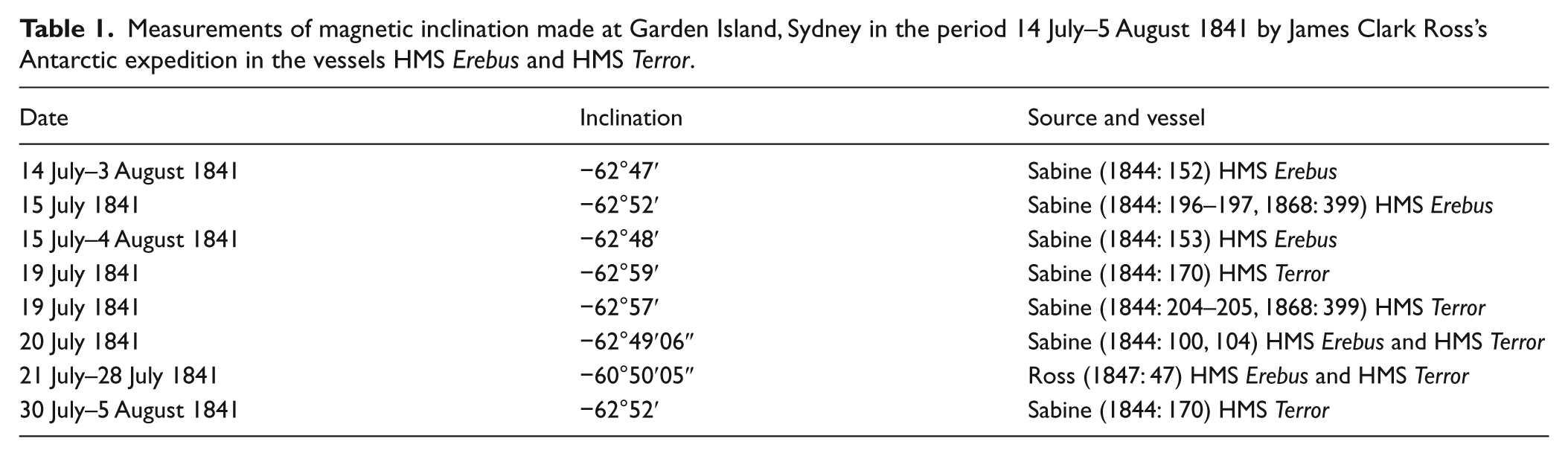
An inclination record of −60°50′05″ made by James Clark Ross (1847: 47) in the period 21–28 July 1841 at Garden Island in Sydney differs significantly from seven other observations made during the same period and at the same site during the course of this expedition (Table 1). Given the existence of a considerable number of concordant observations from this site at this time and the unlikelihood of Ross’s highly anomalous observation representing the product of short-term fluctuations of the magnetic field, we have removed his record from our data set.
Measurements of magnetic inclination made at Garden Island, Sydney in the period 14 July–5 August 1841 by James Clark Ross’s Antarctic expedition in the vessels HMS Erebus and HMS Terror.
The problem with La Pérouse
The earliest observation of magnetic inclination in Australia was made on 1 May 1770 by James Cook, who recorded a dip of −67°01′ at Botany Bay, 16 km south of Sydney (Green and Cook, 1771: 420). Cook’s measurement was replicated on 22 January 1788 by the French explorer, Jean-François Galaup de La Pérouse, who reported an inclination of −56°32′00″ less than 250 km offshore of Botany Bay along the same line of latitude (de Milet-Mureau, 1797a: 350–351).
The difference of more than 10° between La Pérouse’s observation and that of Cook may be the result of operator error. It is also possible that the records reflect a rapid shift in field direction. On the other hand, this is not the only instance of disagreement between the inclination measurements of La Pérouse and those of other explorers from this period. We may consider, for example, the series of observations made in the Sandwich Islands (Hawaiian Islands) by Cook, La Pérouse and George Vancouver between
Measurements of magnetic inclination made in the Sandwich Islands (Hawaiian Islands) between

Latitude and longitude taken from the location of HMS Resolution (Beaglehole, 1967: Figure 14).
The two inclinometers employed by La Pérouse had been supplied to the expedition by Joseph Banks, the President of the Royal Society. These were the instruments that had been used on Cook’s last voyage and were accepted by La Pérouse with, as he put it, feelings of religious respect (de Milet-Mureau, 1797b: 247, 1797c: 8). Just over a month after leaving France, La Pérouse took the opportunity of a stop in Tenerife to test the inclinometers:
… nous trouvâmes très-peu d’accord dans les résultats, et nous ne les rapportons que pour prouver combien cette espèce d’instrument est encore éloignée du point de perfection nécessaire pour mériter la confiance des observateurs. [… we discovered very little consistency in the results, and we shall report them only to show how little this instrument has reached the level of perfection necessary to gain the confidence of observers.] (de Milet-Mureau, 1797c: 17–18).
La Pérouse suggested that the iron content of the soils on the island (Tenerife is largely composed of basaltic lavas) had contributed to the ‘énormes différences’ between the inclination readings (de Milet-Mureau, 1797c: 18), although this seems an unlikely explanation assuming that measurements were made using both instruments at the same sites. In any case, differences of up to 30° between the instruments persisted. Evidence of this comes from a comparison of the measurements of inclination made on the two vessels that constituted La Pérouse’s squadron, La Boussole and L’Astrolabe. It seems reasonable to assume that each craft carried one of the inclinometers loaned to the exped- ition by Joseph Banks. This being the case, Figure 1 shows the records of inclination for all those days on which measurements were made on both vessels. Although we do not know whether the readings were made concurrently nor do we know how far apart the vessels were on each day, we should anticipate similar results from the two instruments on each occasion. Instead, the data reveal a series of systematic discrepancies between the two sets of measurements. Between September 1785 and January 1786, the measurements made on L’Astrolabe were of the order of 10° shallower than those made on La Boussole, whilst from April to May 1786, the difference increased to around 25–30°. The final replicate measurement, taken on 25 October 1786, shows L’Astrolabe’s reading to be 7° steeper than that of La Boussole. This discrepancy did not exist when the same instruments were used during Cook’s last voyage (see, for example, the consistent readings from the Resolution and the Discovery shown in Tables 2 and 3). It is unclear which of the two instruments was giving the incorrect readings (or whether both sets of readings were in error). Nor is it possible to determine whether the step change in the discrepancies in early
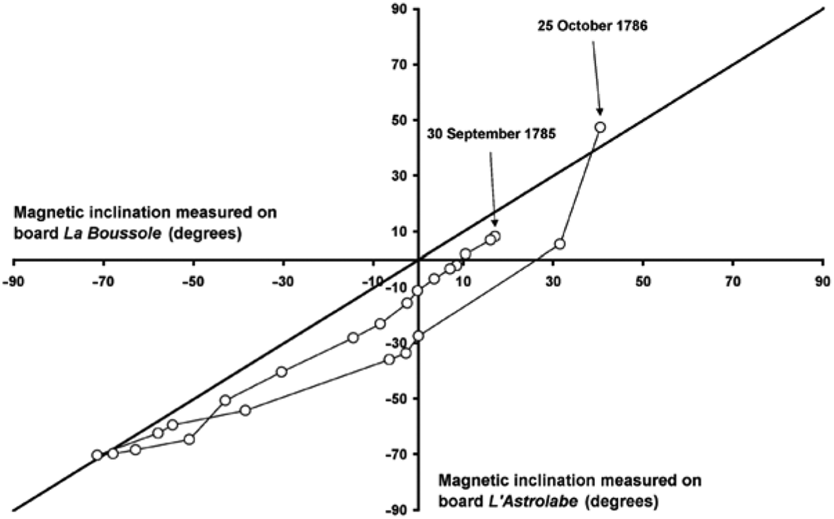
A comparison of the measurements of the inclination of the Earth’s magnetic field made onboard L’Astrolabe with those made onboard La Boussole during La Pérouse’s voyage. The records are in chronological order from 30 September 1785 to 25 October 1786 and represent all those days on which inclination was measured on both vessels. Source: de Milet-Mureau (1797a).
Measurements of magnetic inclination made in southeast Australia between
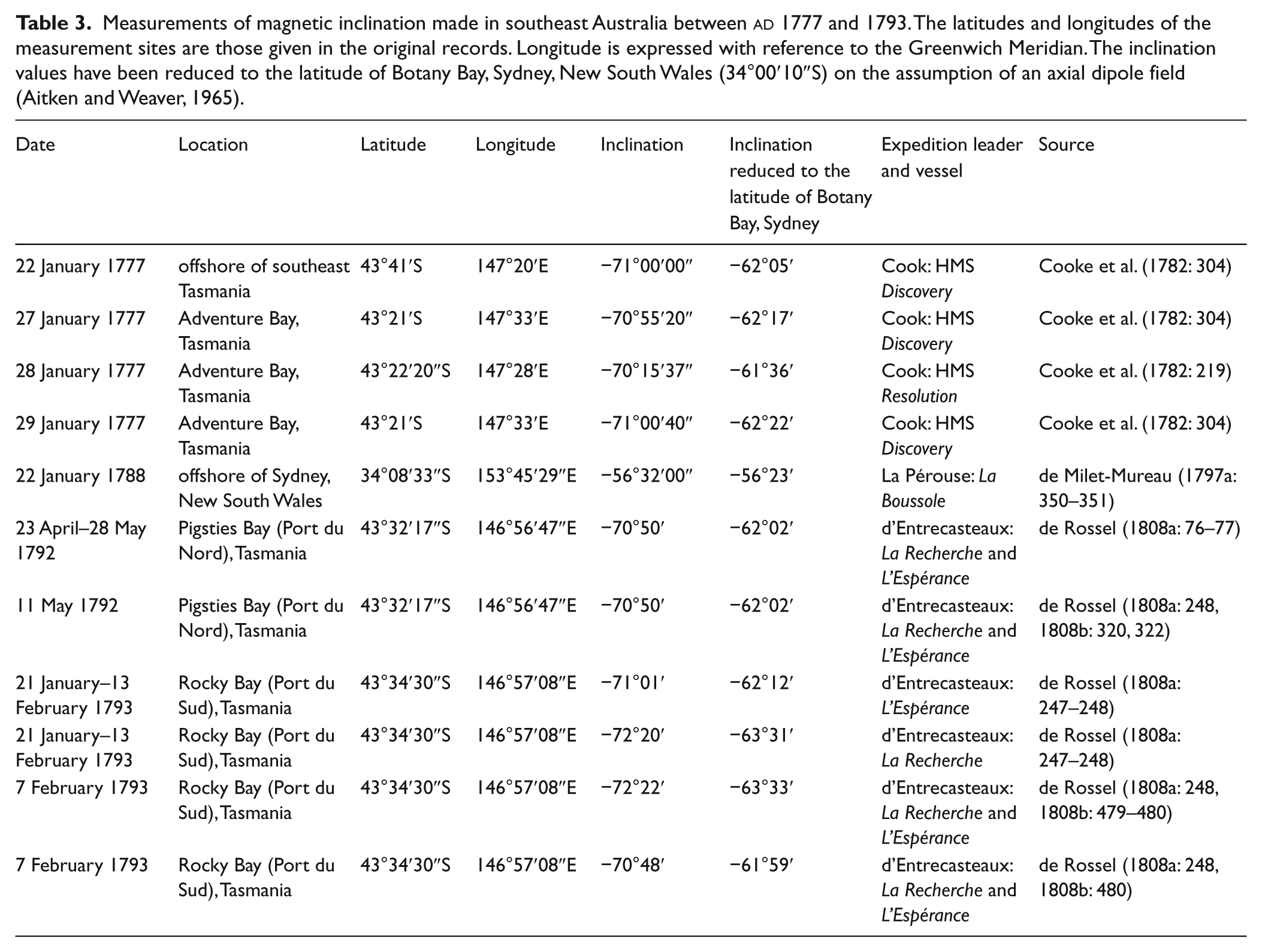
Given the general unreliability of his inclination measurements, we have removed the record of magnetic inclination made in eastern Australia by La Pérouse from our data set. Further support for this step comes from the four inclination readings made by Cook in Tasmania in January 1777 (Cooke et al., 1782: 219, 304) and the six measurements of inclination made in Tasmania in 1792–1793 by de Rossel (1808a: 76–77, 247–248, 1808b: 320, 322, 479–480) (Table 3). These observations closely bracket the date of La Pérouse’s measurement. After reduction to the latitude of Sydney (Aitken and Weaver, 1965), it is clear that the Tasman- ian readings differ markedly from that of La Pérouse (Table 3). Although this difference may be the result of rapid, short-term variations in field direction, when coupled with the other evidence assembled here, it adds weight to the argument concerning the untrustworthiness of La Pérouse’s measurements.
We should point out that discrepancies between the records of La Pérouse and those of other late 18th-century observers were noted 200 years ago by the Norwegian astronomer and physicist, Christopher Hansteen (1819: appendix: 148). However, Hansteen’s observation, tucked away as an endnote to an appendix, appears to have been overlooked for almost two centuries. Moreover, Hansteen offered no explanation for the difference, which he regarded as an ‘insoluble riddle’ [unauflöƒsliches Räthsel]. This oversight may have had significant implications, for La Pérouse’s data, which make up 13% of the total body of pre-19th century inclination records (Jonkers et al., 2003), have repeatedly been employed in efforts to model historical field variations.
The final data set, including the archaeomagnetic records, is given in Table 4. This compilation, excluding all measurements made whilst at sea and excluding the anomalous observations of La Pérouse and Ross, is plotted in Figure 2. This constitutes the eastern Australian Inclination Record (eAIR2012).
Records of magnetic inclination in eastern Australia between c.

The central estimates of the 14C dates represent the medians of each calibrated range.
Mean of the measurements made using the two reliable dipping needles.

The eastern Australian Inclination Record (eAIR2012). This is based on terrestrial observations of magnetic inclination made since
The eastern Australian Inclination Record
Historical observations of the 18th century inclination anomaly
The most striking feature of the eAIR2012 data set is the inclin- ation anomaly of the 18th century, when inclinations appear to have been steeper than at any time since the start of the Holocene. The evidence for this feature is based on three data points. One of these, Cook’s measurement at Botany Bay, is of critical signific- ance since it represents the earliest direct observation of inclination in the entire record. Measurements of inclination during this period were laborious and time-consuming to make (Hutchins, 1776: 179) and the dipping needles employed for this task had a reputation for being difficult to use (Nugent, 1800: 379–381). Given this, how much confidence may we place in Cook’s records? Cook and his astronomer, Charles Green, measured magnetic inclination at 13 locations during their voyage. At least six of these locations were at sea and Green and Cook (1771: 419) considered these ‘… a little dubious on account of the motion of the ship …’. At least one and perhaps three of the remaining observations were made onboard the ship whilst at anchor. These measurements may have been compromised by the presence of ferrous materials on the vessel. Compounding these problems of data quality is Green’s death on the homeward leg of the voyage, which meant that he was unable to supervise the final publication of his data (Green and Cook, 1771: 421). His observations were collated by Cook and by Nevil Maskelyne, the Astronomer Royal, from what appears to have been a confused and incomplete set of records (Cook, 1771).
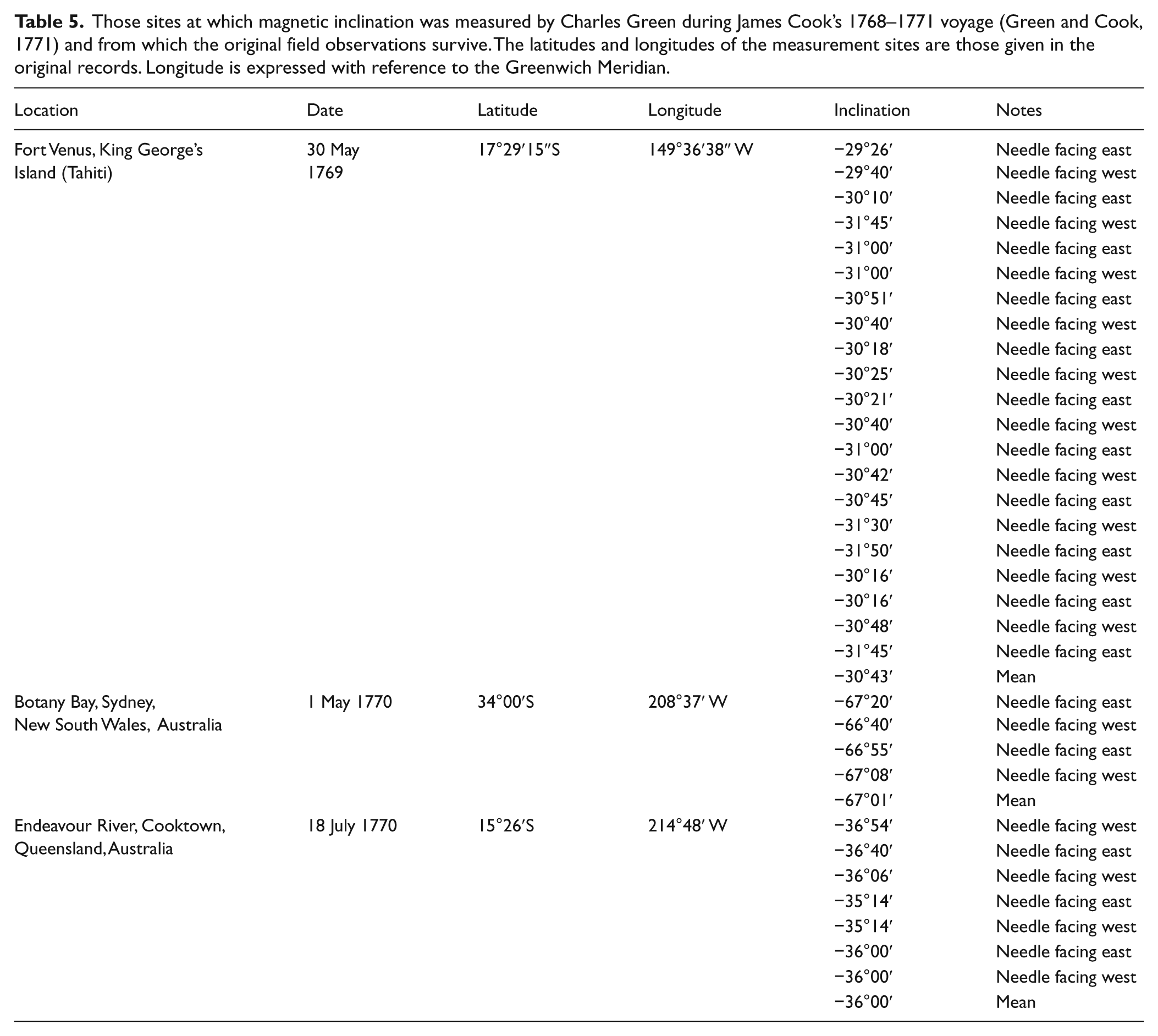
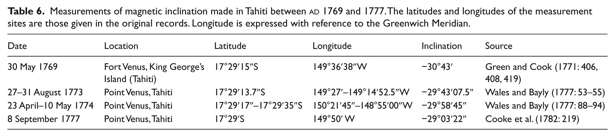
For those observations made at sea and for the three sets of measurements that may have been made onboard the ship, only a single mean value of inclination survives and we possess no measure of the precision of the observations from which this value was calculated. Of the remaining four locations, three possess a complete record of every measurement made. Importantly, at these locations, all measurements were made onshore and under no pressure of time. The sites in question are King George’s Island (Tahiti), Botany Bay and the Endeavour River, close to Cooktown in modern Queensland. The records from these sites are given in Table 5. In each case, the values lie within a narrow range and the precision of the measurements is relatively high. Testing for systematic errors, however, is less straightforward. One approach is to compare Green’s observations with similar measurements made shortly afterwards at nearby locations. This involves making assumptions about variations in magnetic inclin- ation over space (since some of the comparative data come from different locations to those studied by Green) and time (since it was at least four years before suitably equipped vessels returned to these waters and additional measurements were made). Perhaps more significantly, the only corroborative records of Green’s Botany Bay observations, those of La Pérouse, have been shown to be badly compromised and thus cannot be used to check measurements at this site. The available comparative data for Tahiti and the Endeavour River are shown in Tables 6–7. The measurements (particularly those made most shortly after Cook’s voyage) are closely comparable with those of Green. Those terrestrial locations for which full accounts exist thus appear to possess credible and precise records of the dip of the Earth’s field at the time of measurement. The measurements made at Botany Bay are likely to be similarly reliable.
Those sites at which magnetic inclination was measured by Charles Green during James Cook’s 1768–1771 voyage (Green and Cook, 1771) and from which the original field observations survive. The latitudes and longitudes of the measurement sites are those given in the original records. Longitude is expressed with reference to the Greenwich Meridian.
Measurements of magnetic inclination made in Tahiti between
Measurements of magnetic inclination made in northeast Australia and Vanuatu between

Sedimentary records of the 18th century inclination anomaly
Evidence of the 18th century inclination anomaly may also be preserved in sedimentary records from across eastern Australia, although this has not previously been recognised. In southwest Victoria, for example, the steepest inclinations of the last 10,000 years occur just below the top of core KF from Lake Keilambete (Barton and McElhinny, 1981), whilst cores K1D and K1F from the same lake show inclinations steepening steadily after the middle of the first millennium
The sediments from Lake Eacham in northeast Queensland may also record the 18th century inclination anomaly, exhibiting an inclination peak (of nearly −80°) in the last few centuries, with the overlying measurements recording a rapid shift in inclination towards that of the axial dipole (Constable and McElhinny, 1985). Similarly, the 18th century inclination peak may be recognised in speleothem deposits from Forbes’ Second Discovery Cave in northwest Queensland (Fischer, 2001). Although the low chronological resolution and slow sedimentation rate demand caution in interpretation, the actively growing stalagmite exhibits an inclin- ation maximum immediately beneath a 230Th/234U age of 200±200 years (±1 ơ). This is the steepest record in a sequence believed to be continuous back to approximately 300
To the east, the record of magnetic inclination from New Zealand (Robertson, 2007) reveals a progressive steepening of inclin- ation over the last 1000 years that is closely comparable with that shown by the eAIR2012. The 18th century inclination anomaly is missing from the New Zealand record, however, suggesting an eastward limit to the extent of this phenomenon.
Testing the eAIR2012 against independent sedimentary records
Evidence of the 18th century inclination anomaly may thus be observed at a range of sites throughout eastern Australia. Unfortunately, these records are poorly dated. Significantly too, the exist- ence of the anomaly in the eAIR2012 is based on only three data points, two of which are associated with significant chronological and directional uncertainties. In addition, the archaeomagnetic measurements that make up the basal part of the eAIR2012 are too sparse and too uncertain to provide a reliable measure of changes in field direction over the earlier part of the period. In order to assess the reliability of the eAIR2012, and particularly the 18th century inclination anomaly, we therefore sought to compare the record with independent histories of magnetic inclination in eastern Australia over the last millennium. To obtain this information we sampled lake sediments from Tocal Homestead Lagoon in the Hunter valley of central eastern New South Wales and Big Jibbon Lagoon to the south of Port Hacking in central eastern New South Wales. Percussion cores of sediments were obtained from each site using 50 mm diameter polyvinyl chloride tubing. Each tube was sealed and transported directly to the laboratory, where repeated downcore measurements of magnetic inclination were made using a 2G Enterprises long-core cryogenic magnetometer.
Tocal Homestead Lagoon
Tocal Homestead Lagoon is known to possess an undisturbed, well-dated and high-resolution record of sedimentation extending back at least two millennia (Cook, 2006; Gale and Cook, 2006). Two cores (TCA9e and TCA9f) were extracted from site TCA9 in the lake. The inclination patterns of each core were closely comparable (Figure 3). Since core TCA9f possesses a longer and more highly resolved record than TCA9e, this was selected for more detailed analysis. An oriented pilot specimen from the core was chosen and the stability of its remanent magnetisation was examined by progressive stepwise demagnetisation in alternating fields up to a maximum strength of 40 mT. The direction and intensity of magnetisation after each demagnetisation step was measured using a 2G Enterprises cryogenic magnetometer. The direction of magnetisation did not change significantly with demagnetisation, with no indication of a viscous or weaker secondary chemical remanence (Figure 4). Measurements of natural remanent magnetisation were therefore considered to be indicative of primary magnetisation and thus of the direction of the past field at the site.
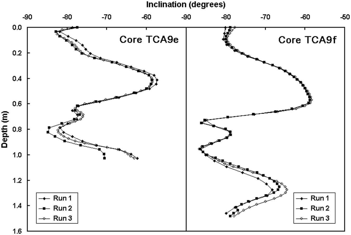
The results of repeat measurements of the downcore variation in the inclination of the natural remanent magnetisation of cores TCA9e and TCA9f from Tocal Homestead Lagoon, central eastern New South Wales, Australia.
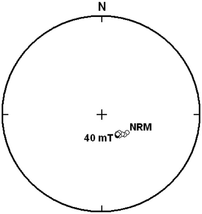
The direction of magnetisation of specimen TCA9f2 from 0.06 m to 0.12 m in core TCA9f from Tocal Homestead Lagoon, central eastern New South Wales, Australia during progressive stepwise demagnetisation in successive peak alternating fields of 2, 4, 6, 8, 10, 12, 16, 20, 30 and 40 mT. The natural remanent magnetisation is labelled NRM. The measurements are plotted on the upper hemisphere of an equal-angle stereographic projection. Note that the measurements of declination were made with respect to an arbitrary datum and should not be taken as representative of actual palaeomagnetic direction.
The increase in inclination in the upper few centimetres of each core is probably an edge effect resulting from the integration of magnetometer sensor readings beyond the top of the core barrel. Below this, there are notable similarities between the inclin- ation records of TCA9e and TCA9f and those of the eAIR2012. In both the sediments and the observational records, inclinations become gentler with depth, reaching a minimum of around −60°, although the amplitude of change is greater in the sediment records. Below this point, both sets of inclination records steepen sharply to the steepest values in the sequence. The sediment records indicate that this feature is made up of twin peaks, although the sparsity of data means that these individual components cannot be distinguished in the eAIR2012 sequence. Beneath this, inclination values in both records become progressively less steep. In the longer of the two sedimentary records, TCA9f, the basal part of the sequence is characterised by a steepening of inclination. This may correspond with the shift that occurs in the eAIR2012 during the 11th century, though the incomplete nature of the archaeomagnetic data set means that such a correlation can only be speculative at this stage.
In order to constrain the timing of the inclination episode in the sedimentary sequence, samples were taken for accelerator mass spectrometric 14C analysis from the two inclination peaks in the record. The results are shown in Table 8.
Accelerator mass spectrometric 14C determinations from core TCA9f, Tocal Homestead Lagoon, central eastern New South Wales, Australia. The ages have been calibrated to calendar years using the CALIB 6.0 Radiocarbon Calibration Program of M Stuiver, PJ Reimer and R Reimer, employing the SHCal04 data set of McCormac et al. (2004).
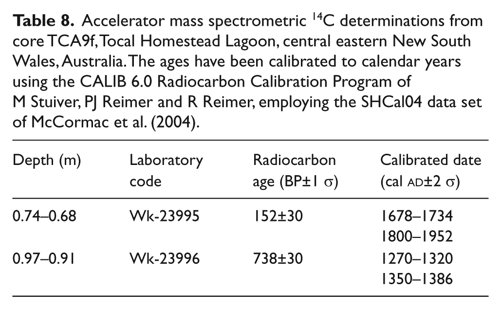
The younger of the two dates is statistically indistinguishable from, but is more precise than the date of cal.
The older of the two inclination peaks in the Tocal Homestead Lagoon record is associated with a date of cal.
Big Jibbon Lagoon
The record of magnetic inclination from core BJL B4.0 from Big Jibbon Lagoon in central eastern New South Wales is shown in Figure 5. The results are equivocal, but they display evidence of similar trends to those observed in Tocal Homestead Lagoon. In particular, the upper part of the sequence exhibits twin peaks in inclination comparable with those seen in the Tocal Homestead Lagoon record. This part of the Big Jibbon Lagoon sequence is not well dated, though the basal date of the 210Pb chronology lies just above the upper inclination peak, confirming that both the inclination peaks pre-date European contact.
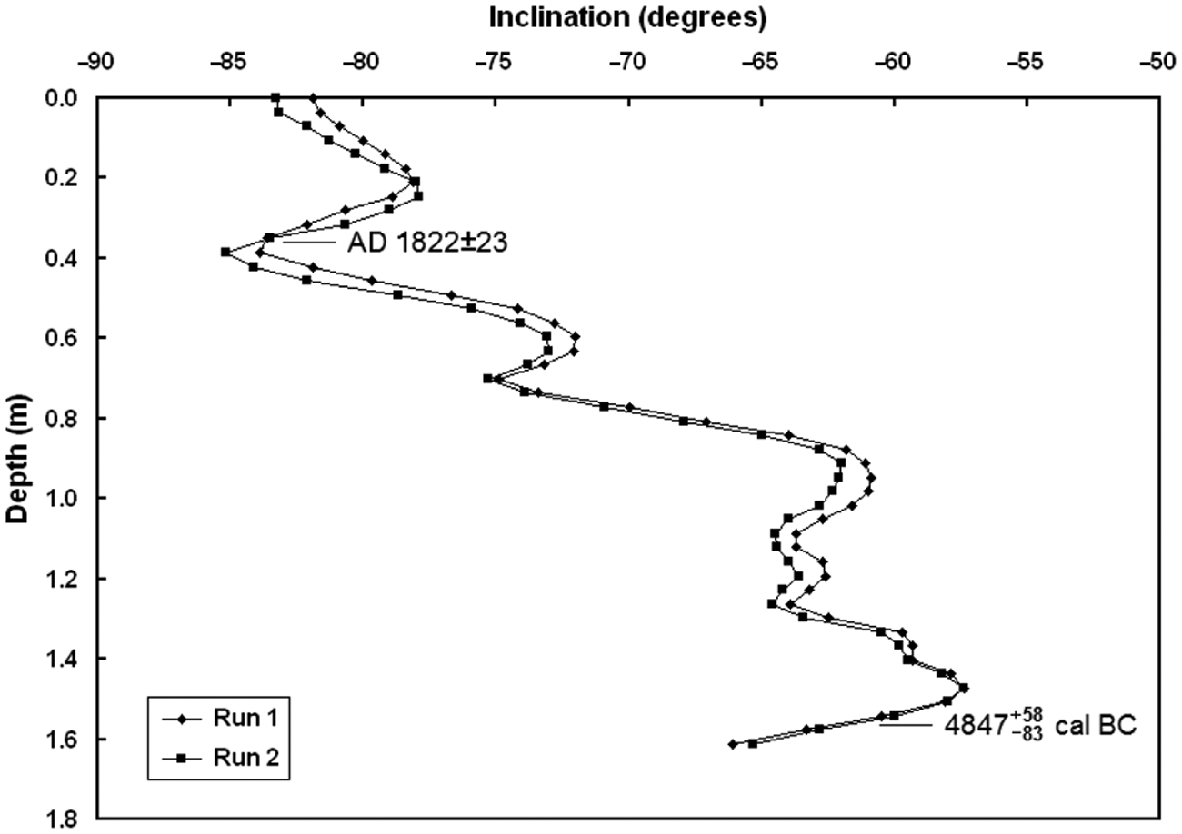
The results of repeat measurements of the downcore variation in the inclination of the natural remanent magnetisation of core BJL B4.0 from Big Jibbon Lagoon, central eastern New South Wales, Australia. The upper date is the basal value of a 210Pb chronological sequence, the lower date is an accelerator mass spectrometric 14C determination (Beta-305851) calibrated to calendar years using the CALIB 6.0 Radiocarbon Calibration Program of M Stuiver, PJ Reimer and R Reimer, employing the SHCal04 data set of McCormac et al. (2004). Following the recommendations of Telford et al. (2004), the central estimate of the 14C date represents the median of the calibrated range. Dates are expressed with an uncertainty of ±1 σ.
It is thus possible that the inclination anomaly is more complex than revealed by the eAIR2012 record and that it may be a composite feature characterised by two inclination peaks, the entire episode having a lifetime of around 500 years.
Discussion
Although the 13th–18th century inclination anomaly has not previously been identified in Australia, it may be associated with a short-lived, large-scale magnetic feature to the north of Australia that is revealed in a series of global geomagnetic field models. These include gufm1 (Jackson et al., 2000), based largely on historical maritime records, and a sequence of models derived from archaeomagnetic, lava flow and lake sediment records (Constable et al., 2000; Korte and Constable, 2003, 2005). Despite employing rather sparse sets of data from the Australian region, all these models show the presence of a negative inclination anomaly in the region during this period. The CALS7.2 model (Korte and Con- stable, 2005), for example, clearly reveals the development of a large-scale negative anomaly to the north of Australia in the decades before
The rapid shifts in the inclination of the geomagnetic field during this period provide easily identifiable palaeomagnetic event markers that offer considerable potential for dating materials deposited immediately prior to the European colonisation of the eastern seaboard of the continent. There are few established dating techniques capable of providing a high-resolution chronology of this period. These markers afford a means of improving this situation. In particular, the steep shift and finely resolved chronology that mark the end of the 18th century inclination maximum provide a tool for the identification one of southeast Australia’s most intractable chronological datums, the point of European contact.
Conclusions
The eAIR2012 offers three important insights into recent secular magnetic change. First, it has allowed us to identify a well-defined magnetic inclination anomaly in eastern Australia that may have spanned the period between the 13th and 18th centuries. The dip of the field during this time seems to have been greater than at any stage since the start of the Holocene. The episode appears to have been characterised by two steep inclination peaks. Although the earlier is of equivocal status, it has been identified in the sediments of Tocal Homestead Lagoon, where it has been dated to cal.
Second, the eAIR2012 provides valuable constraints on attempts to model regional changes in the geomagnetic field over millennial and centennial timescales. In particular, it yields information on the timing and extent of the major inclination anomaly revealed by global magnetic field models across island southeast Asia and Australasia during the last 700 years.
Third, the inclination measurements made by the 18th century French explorer La Pérouse appear to be consistently erroneous. As there are so few geomagnetic data from this period, the inclusion of these measurements in global compendia of magnetic observations may seriously skew attempts to model the geomagnetic field. We advocate that La Pérouse’s data should be employed only with considerable caution.
Footnotes
Acknowledgements
Professor BJ Pillans and Dr PW Schmidt generously allowed us to use their laboratories to determine the palaeomagnetism of our cores, whilst offering invaluable advice and technical support. The British Geological Survey’s World Data Centre for Geomagnetism, Edinburgh, UK provided access to magnetic observations made in eastern Australia after 1900, and granted permission for their reproduction here. We thank Associate Professor MF Barbetti, Lieutenant-Commander ACF David, Dr PP Hesse, Dr PG Hoare, Professor A Jackson, Dr S Macmillan, Dr DJ Robertson and Associate Professor DE Winch for their helpful contributions to this research.
Funding
This research was undertaken whilst DEC was in receipt of a Henry Bertie and Florence Mabel Gritton Research Scholarship at The University of Sydney, Australia. We gratefully acknowledge financial support for this work from the Betty Mayne Scientific Research Fund for Earth Sciences administered by the Linnean Society of New South Wales and from the Australian Institute of Nuclear Science and Engineering.