
Abstract
Coarse-grained flood deposits, including 52 discrete berms, bars, terraces, splays and sheets, were investigated along a 6.6 km stretch of the Leira river, in a catchment containing several alpine glaciers. These landforms were mapped, characterized in terms of clast size and reconstructed hydrological parameters, and dated using several techniques with differing temporal range and resolution. High-resolution lichenometric dating indicated that 60–65% of the deposits date from the 20th century whereas 5.7% are 300–600 years old. In contrast, low-resolution Schmidt-hammer exposure-age dating (SHD) indicated that 85% of deposits have an age <500 years whereas 13.5% are older deposits with age estimates of 1000–6000 years. Simple indicators of soil development and vegetation succession demonstrated extensive recent disturbance of most surfaces by floods. Optically stimulated luminescence (OSL) and radiocarbon dating of fine-grained flood layers and buried palaeosols confirmed the existence of flood deposits spanning the whole of the Holocene. Apparent discrepancies between dating techniques are explained by a complex pattern of overwashing and reworking, which is related to height of flood deposits above the active river channel, and downstream patterns of disturbance associated especially with tributary confluences. While, in general, these deposits are of low persistence and most are highly sensitive to disturbance, some elements of the valley-floor landscape have persisted throughout the Holocene. Comparison of this fragmentary geomorphological record of floods with the historical flood record shows that the surviving deposits are sensitive to recent multidecadal-scale glacier and climatic variations.
Keywords
Introduction
River systems are sensitive to different types of disturbance, including the impact of floods of different magnitudes and frequencies linked to Holocene climatic changes (e.g. Macklin et al., 2010, Piccarreta et al., 2011). Long-standing research questions include the immediate geomorphic impact of extreme floods as formative events and agents for change in fluvial environments (Wolman and Miller, 1960), and the longer-term persistence of the flood landforms, as evidenced by flood deposits and floodplain stratigraphy (Anderson and Calver, 1977; Calver and Anderson, 2004; Costa, 1974; McEwen and Werritty, 2007; Milan, 2012; Miller, 1995; White et al., 2010; Wolman and Gerson, 1978). Both are affected by the local physiographic setting although much more is known about impact than persistence (Baker, 1977; Gupta, 1983; Kochel, 1988; McEwen and Werritty, 1988; Magilligan et al. 2002; Nanson, 1986; Ritter et al., 1999; Wohl, 2007).
Assessing landscape sensitivity involves evaluating both propensity for landscape change, and the capacity of the system to absorb that change (Brunsden and Thornes, 1979). Werritty and Leys (2001) distinguish between sensitive and robust fluvial landforms. Variations occur in the extent that flood deposits are sensitive to, and reflect, changes in controls within the wider catchment. Significant research has focused on the sensitivity of temperate river systems to floods and ‘flood rich’ periods over late-Holocene (e.g. Macklin et al., 2010; Rumsby and Macklin, 1994; Werritty and Leys, 2001) and Holocene timescales (Jones et al., 2010). Analysis of the palaeoflood record and its geomorphic legacy has potential to lead to better understanding of how future climatic changes might influence flood magnitude and frequency and potential river response.
Approaches to reconstructing geomorphic evidence of changing hydrological patterns using both dating of coarse-grained deposits and archival research of hydrological observations have tended to focus on the late Holocene, where the evidence base is most extensive. A particular focus is the period of warming in the latter stages of the ‘Little Ice Age’ (e.g. Astrade et al., 2011). A paucity of research, however, appraises the geomorphic persistence of flood deposits during Holocene valley-floor development in alpine glacier- and nival-fed river systems. Here flow regimes, available stream powers during floods, and sediment supply, will all have varied over the Holocene, linked to fluctuating glacial activity. For example, while the timing of glacial and colluvial activity in alpine areas of southern Norway during the Holocene has been well researched (e.g. Matthews et al., 1997, 2000, 2005, 2009; Matthews and Dresser, 2008; Nesje, 2009; Nesje et al., 2008a), only limited assessment has been made of river system adjustment both locally and downstream (Bøe et al., 2006; Nesje et al., 2001a). Over this timescale, Norwegian mountain rivers draining glaciated areas are known to have undergone paraglacial adjustment, and to have responded to neoparaglacial episodes, with significant adjustments in discharge and sediment supply (Matthews and Dresser, 2008; Matthews et al., 2005).
Evidence from flood deposits, both slack water deposits and flood berms, has been used in a variety of environments to characterise the alluvial record (Jones et al., 2010) and to reconstruct flood series in the context of Holocene climate changes (e.g. Grossman, 2001; Macklin et al., 1992; Merrett and Macklin, 1999). Coarse-grained flood deposits can be differentiated in several ways, in relation to: calibre and form; position relative to the active river channels, floodplain, terraces, colluvial deposits and valley sides; degree of clast weathering; and the nature of the lichen cover (e.g. Macklin et al. 2010; Waythomas and Jarrett, 1994). Flood deposits can be located within the current active zone but can also be detached from current processes, produced by historic flood flows over floodplains. The calibre of such deposits allows reconstruction of the relative magnitude and stream power of floods and ‘flood rich’ periods, and the impact and persistence of these events in the landscape. Timing of the floods that produce coarse-grained flood deposits has been estimated using geochronological tools, including optically stimulated luminescence, radiocarbon dating and lichenometry (e.g. Gob et al., 2003; Macklin et al., 2010), thus providing detail about flood magnitude and frequency prior to gauged flow records. However, linking flood deposits to specific historic flood events is often challenging.
This paper investigates the depositional legacy of floods affecting the valley-floor in the River Leira catchment, an alpine glacially fed tributary of the Bøvra in north-central Jotunheimen, the highest mountains in Scandinavia. The Leira has an exceptional frequency of coarse-grained flood deposits within the region. The overall aim is to evaluate the sensitivity and persistence of the geomorphological record of floods on the Holocene timescale. Specific objectives are:
(1) to describe the down-valley variation in flood geomorphology;
(2) to estimate the ages of the surviving flood deposits, using several dating methods;
(3) to estimate from the sedimentary record the competence of the floods;
(4) to link the dated flood deposits to the historical record of flooding;
(5) to assess the persistence of flood landforms in the valley-floor landscape; and
(6) to assess the sensitivity of these depositional records to Holocene glacier and climatic fluctuations.
Environmental setting
The main study area is the upper to middle Leira (Figure 1). The study reach, 6.6 km in length, extends from the Storebregrovi confluence (fed by Storbreen) to the distal valley sandur at Ytterdalssaeter. Six major glaciers, in downstream order – Storbreen, Veslebreen, Hurrabreen, Norde and Søre Illåbreen, and Høgskridubreen – contribute discharge and sediment along this section of the Leira. Upstream of the study reach, the Leira is bedrock controlled with limited sediment supply. Along the study reach, a sequence of locally constricted sections with total or partial bedrock control act as local base-levels for a series of less confined, divided, alluvial sedimentation zones that increase in length and width downstream. The largest of these zones are associated with inputs of discharge and sediment from tributary glacial outwash fans. The largest tributary, the Illåe (fed by the Norde and Søre Illåbreen glaciers) debouches an extensive fan that confines the lateral migration of the middle Leira (Figure 1; McEwen, Matthews, Owen et al., unpublished data, 2011). Here, there is a step increase in catchment area with the addition of the both Hurra and Illåe rivers at 3.3–3.8 km downstream of Storbreen. Further downstream, the study area culminates in a 2 km zone occupied by a braided, valley sandur extending to the major bedrock-controlled base-level near Ytterdalssæter.
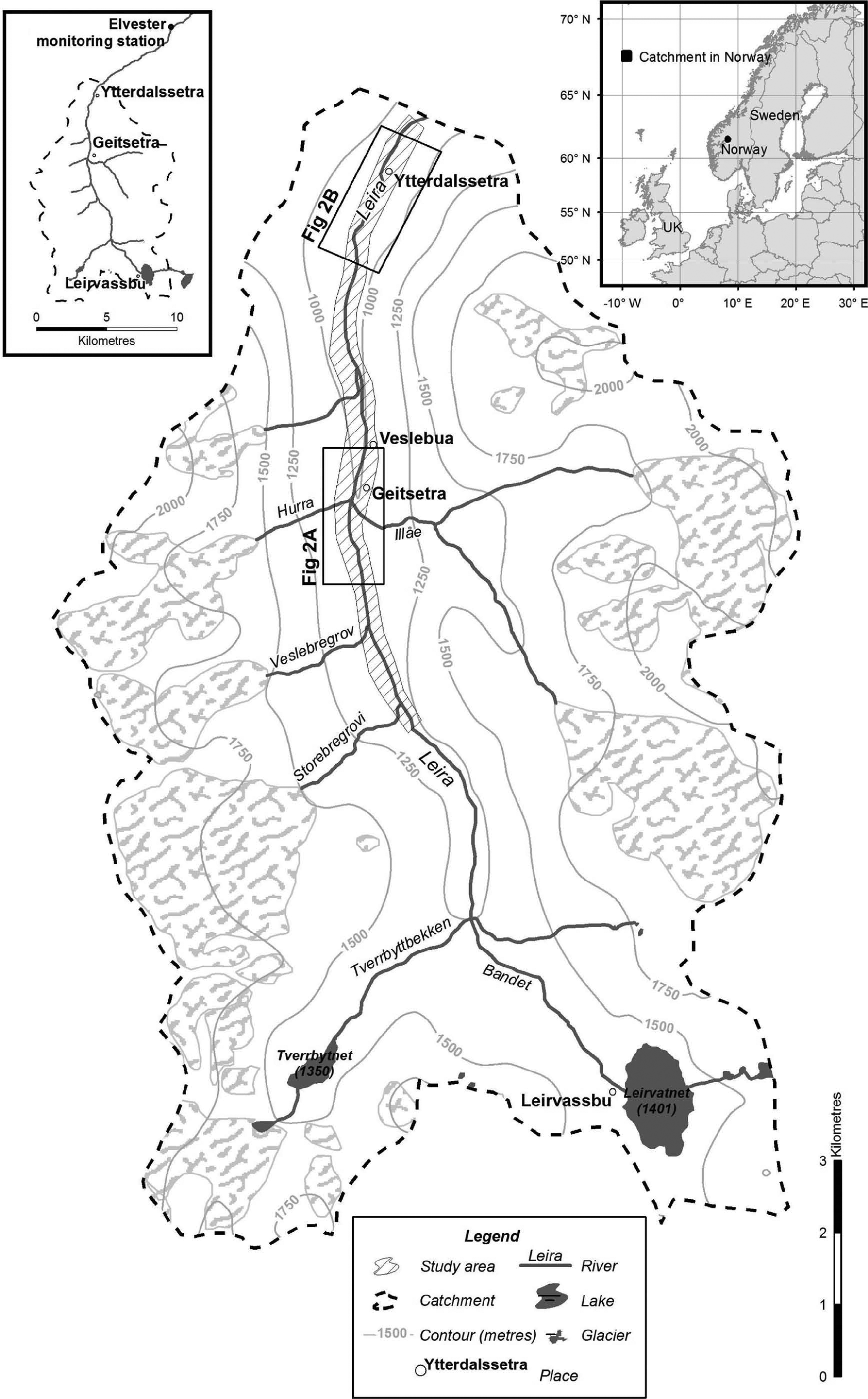
Location and study area.
Reconstructed Holocene glacier fluctuations in the Smørstabbindan massif, Jotunheimen indicate seven major century- to millennial-scale glacier expansion episodes (‘neoglacial events’) since deglaciation of lower Leirdalen, which occurred shortly before 10,100 cal. BP (Barnett et al., 2001). The earliest of these neoglacial events (Smørstabbtinden I) corresponds with the late Erdalen Event, which ended by about 9700 cal. BP (Dahl et al., 2002; Matthews and Dresser, 2008). At this time, glaciers had retreated well upstream of the Storbregrovi confluence. Later neoglacial events occurred at c. 8400–7650 (Smørstabbtinden II; known more widely in southern Norway as the Finse Event), 4800–3900 (Smørstabbtinden III), 3200–2550 (Smørstabbtinden IV), 2350–1700 (Smørstabbtinden V), 1400–750 (Smørstabbtinden VI) and 500–0 cal. BP (Smørstabbtinden VII; the ‘Little Ice Age’) (Matthews and Dresser, 2008). Glaciers probably melted completely away from at least 7500 to 6500 cal. BP (i.e. between Smørstabbtinden II and III) during the Holocene thermal maximum, after which neoglacial events increased in frequency and magnitude culminating in the ‘Little Ice Age’ event, which followed glacier retraction during the ‘Mediaeval Warm Period’. Within the ‘Little Ice Age’ event, up to three decadal- to century-scale glacier expansions have been recognised, the last of which corresponds with the historically dated glacier maximum of the mid-18th century (Matthews and Dresser, 2008).
Composite regional moraine chronologies for the Jotunheimen, based on lichenometric dating, indicate 12 episodes of moraine formation, including the ‘Little Ice Age’ glacier maximum at
Over the Holocene, vegetation changes are known to have occurred in Leirdalen, with likely impacts on both hydrological regime and sediment supply, including the potential stability of outwash fans. Barnett et al. (2001) provide evidence for long-term changes in forest composition and extent within the sandur zone of the study area. They identified rapid colonisation of Leirdalen by birch (Betula pubescens) and Scot’s pine (Pinus sylvestris) following deglaciation (see also Matthews et al., 2005), and a rapid shift from pine to birch woodland at c. 6870 cal. yr BP. Since c. 4850 cal. yr BP, woodland extent has generally decreased because of climatic deterioration and human impact.
Methodology
An integrated, multiproxy research design was used to map and characterise down-valley variation in flood deposits, assess the relative competence of the floods that generated them, and provide age estimates.
Geomorphological mapping
Aerial photograph evidence (1955, 1960, 1981, 1997 and 2004) and field research were used to map flood deposits and their major controls in Leirdalen. Aerial photography, however, only provides evidence for lateral rather than vertical fluvial adjustment. Consequently, the height of flood deposits and their distance from the current active channel were measured (in 2003), using a Sokkia automatic level.
Sediment and palaeohydrological analysis
The sediment calibre in each flood deposit was sampled using the intermediate (b-axis) of the 50 largest clasts, and representative clast sizes (D50, D84 and maximum clast size) were calculated (Brierley and Hickin, 1985; Bunte and Abt, 2001). Palaeohydrological parameters associated with floods were estimated from the maximum intermediate-axis clast size of deposits (Williams, 1984):


Surface exposure-age dating of flood deposits
Dating of post-1955 valley-floor surfaces was undertaken using aerial photograph evidence. Age estimates of pre-1955 flood deposits were obtained using both lichenometric dating and Schmidt-hammer exposure-age dating (SHD). In lichenometric dating, two approaches were adopted for each flood deposit. First, on each separate surface, the long axis (maximum diameter) of the five largest lichens of the yellow-green, crustose Rhizocarpon subgenus was measured (cf. Matthews, 1974, 2005). The Central Jotunheimen lichenometric dating curve (Matthews, 2005), using the mean of the five largest lichens, was applied to estimate absolute (calibrated) dates of deposition. This growth curve is based on control points (surfaces of known age) using dated moraines from neighbouring glacier forelands.
The second lichenometric approach of ‘mean lichen size’ (McCarroll, 1994) involved measuring the largest lichen on each of 50 of the largest boulders from the surface of each flood deposit, systematically sampled downstream from its upstream end. On some deposits with low availability of larger clasts, a smaller sample size of 25 boulders was used. Where flood deposit surfaces were densely vegetated, mean lichen size could not be used. Both mean lichen size, and the frequency distribution of lichen values were analysed, the latter to identify bimodal or multimodal distributions indicative of episodic disturbance and reworking of deposits. McCarroll’s (1994) mean lichen size growth curve is based on dated moraines from the Storbreen glacier foreland.
In both lichenometric methods, local dating curves were used. However, little previous assessment has been undertaken as to how reliably such curves can be transferred to active river environments with potentially different moisture and snow cover characteristics. There is limited information about the tolerance of Rhizocarpon species to fluvial inundation of different magnitudes and frequencies, and associated corrosion by bedload, siltation and episodic burial.
For SHD, boulders of sufficient size for reliable use of a type-N Schmidt hammer were required. Mean ‘R-value’, based on the mean of three blows on 50 clasts, was used to assess the hardness and hence the degree of weathering of boulder surfaces. Shakesby et al. (2006) calibrated the Schmidt hammer for different types of Preboreal and ‘Little Ice Age’ moraine surfaces. Their results indicate that the Schmidt hammer can separate surfaces that differ in age by at least 2000 years. However, boulders were not sufficiently abundant on the surfaces to use the large sample sizes necessary for high-precision calibrated-age dating as used locally by Matthews and Owen (2010). Schmidt hammer R values were therefore used for low-precision calibrated-age dating of flood deposits using the calibration curve available for Jotunheimen derived from glacial moraines: y = 38498.159 − 668.02999x (the Jotunheimen curve of Matthews and Winkler, 2011; using data from Shakesby et al., 2006). Boulder surfaces affected by biological weathering due to endolithic lichens were avoided (Matthews and Owen, 2008).
Relative age and levels of inundation of flood deposits were also investigated using the extent of soil development, and the stage of vegetation succession. A small excavation pit was dug on each flood deposit surface and the depth of organic A horizon and maximum soil depth were measured. Slow rates of soil development are characteristic of this alpine environment (cf. Mellor, 1985; Messer, 1988). Species percentage cover was assessed using 1 m2 quadrats and vegetation composition was similarly used as a relative-age indicator based on comparison with vegetation on moraines of known age (cf. Matthews, 1992, 1999; Robbins and Matthews, 2009, 2010).
Stratigraphy, radiocarbon and OSL dating
Individual floods or series of flood events were identified through grey layers of silt and fine sand in stratigraphic sections in eroded river banks, in cored floodplains close to the Hurra/Illåe confluence (Figure 2a), and in the lower sandur sedimentation zone (Figure 2b). Exposed banks and terraces were systematically checked for subsurface stratigraphic evidence of flood depositional layers and datable material. Three sections (Geitsæter and Ytterdalssæter I and II) were logged in terms of sediment characteristics, including buried soil horizons. Selected buried organic layers were radiocarbon dated using conventional radiocarbon dating of acid-washed bulk samples (cf. Matthews, 1985). Optically stimulated luminescence (OSL) dating of fine sand was carried out at the Geitsæter site (cf. Lian and Roberts, 2006; Rittenour, 2008).
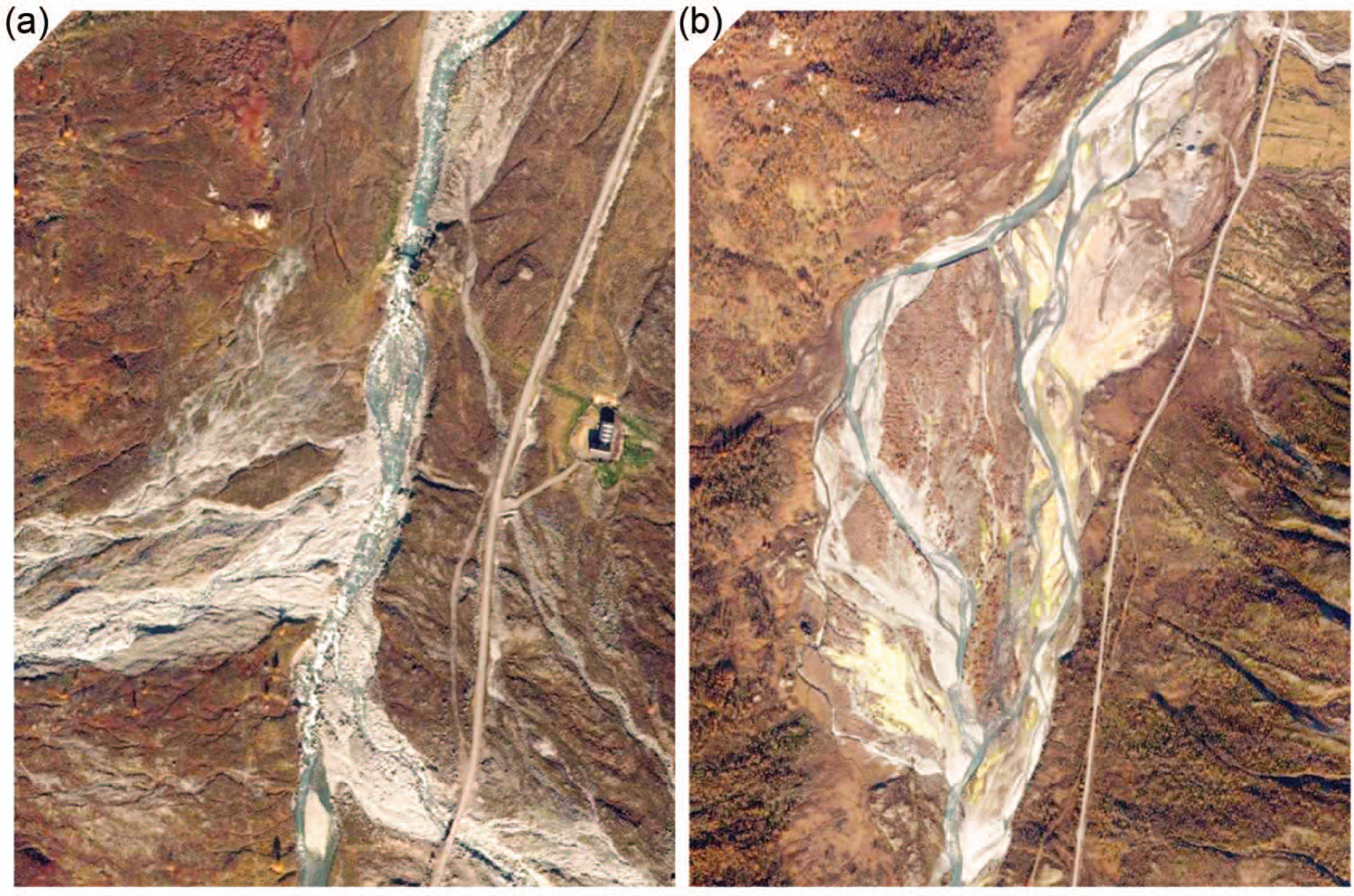
Aerial photographs of (a) the Hurra/ Illåe confluence, showing sediment inputs; and (b) the distal sandur.
Reconstruction of a historical flood chronology
A semi-quantitative historical flood chronology for upper to middle Leirdalen was established from gauged flow records, augmented by evidence from archival sources. The Leira has been gauged at Elveseter (Figure 1) since
Flood information was also collated from documentary sources. Both Grove (1972, 2004) and Roald (personal communication, 2003) have analysed archival sources in old Norse to establish Norwegian flood chronologies. Information about historic flood incidence (mid-17th century to present) in the Bøvra catchment is recorded in local histories including Rekstad (1900), Øyen (1901) and Øyjorde (1967). All these sources are used for three purposes: (1) assessing the magnitude and frequency of flooding during the historical period in Bøverdalen and Leirdalen; (2) exploring links between the historical archival record of floods and the age estimates for the flood deposits; and (3) evaluating possible relationships between the timing of extreme floods, known ‘Little Ice Age’ moraine-building episodes (Matthews, 2005) and Holocene neoglacial events (Matthews and Dresser, 2008).
Results
Distribution of flood deposits
A total of 52 flood deposits were identified. None occur above the Leira’s confluence with the Storebregrovi. These coarse-grained flood deposits comprise various forms: sheets, splays, bars, berms, and terraces (Figure 3). Summary statistics for these deposits are provided in Table 1 while Figure 4 shows their distribution within the study reach. The first set of seven deposits occur downstream of the Storebregrovi and Veslebregrovi confluences; an extended field of 23 deposits are concentrated in the zone downstream of the Hurra and Illåe confluences; and the remaining 22 deposits are scattered further downstream.
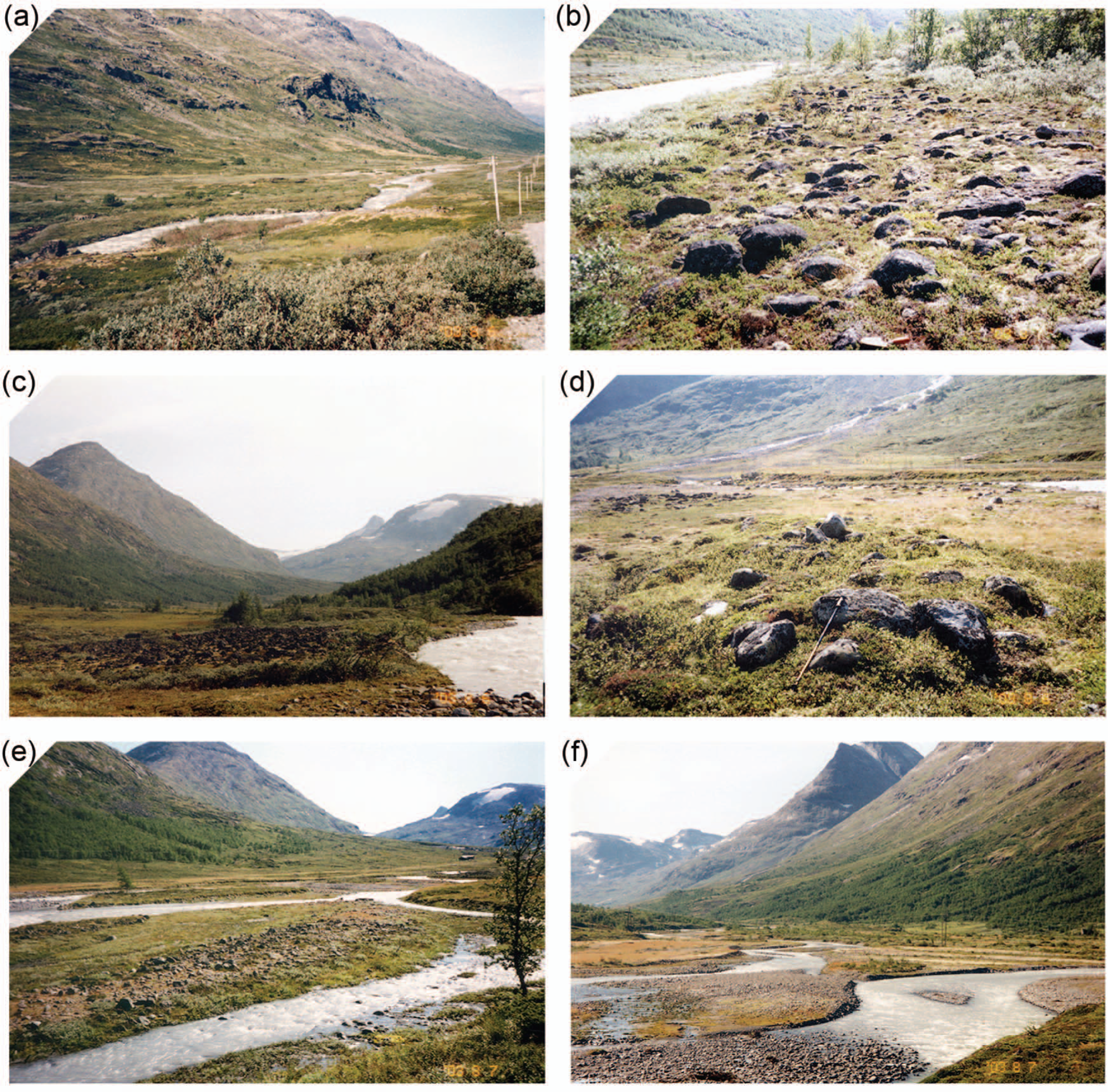
Photographs of coarse-grained flood deposits. (a) Splay (middle ground) below Storebregrovi; (b) terrace deposit below Veslebregovi; (c) sheet deposit – middle reaches; (d) flood berm below Illåe confluence; (e) elongate berm above distal sandur; (f) bar deposits on distal sandur.
Summary statistics for the coarse-grained flood deposits.

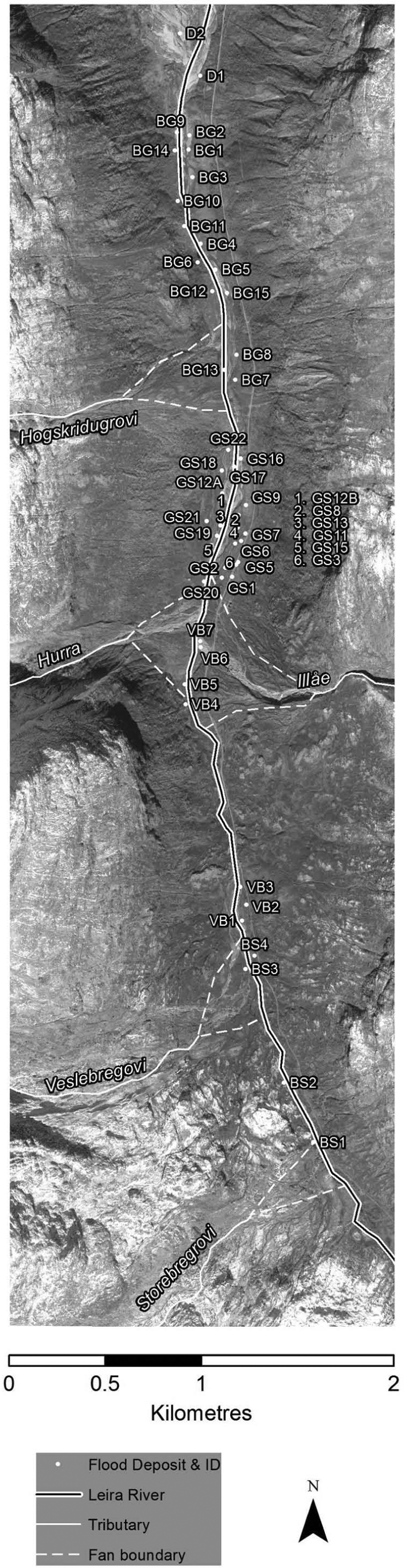
Distribution of coarse-grained flood deposits in the Leira catchment.
The median maximum b-axis of the 50 sampled clasts for all sites is 0.62 m; and the median median b-axis is 0.365 m (Table 1). The median height of flood deposits above the current active channel is 1.6 m, with a maximum height of 3.2 m. Flood deposit height is positively correlated with distance from the active channel (r = 0.48; p<0.05; Figure 5a), and with maximum clast size (r = 0.34; p<0.05; Figure 5b).
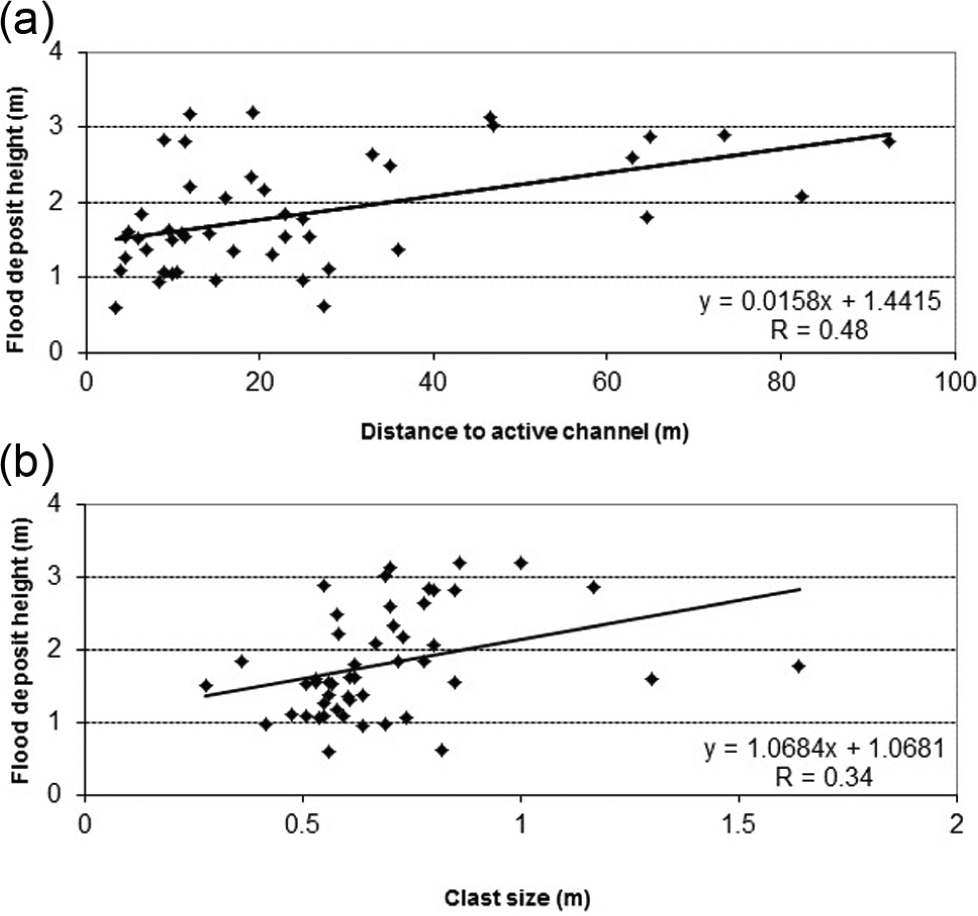
Scatterplots showing flood deposit height against (a) distance from active channel; and (b) maximum clast size.
There is no systematic variation in clast size in the flood deposits with distance downstream. However, the deposits with largest clasts are associated with the Hurra/Illåe confluence (maximum b-axes 1.30/1.64 m and 1.0/1.17 m, respectively; Figure 6a), while the clasts are smallest in the sandur zone (maximum b-axis 0.30 m). Downstream variations in height above, and distance from, the present channel exhibit related patterns: 17 of the flood deposits (32.7%) have a maximum height >2 m, of which 15 (28.8%) are distributed around the Hurra/Illåe confluence zone; and two are located below the Høgskridubreen confluence (Figure 6b). The distance of flood deposits from the active channel varies from < 5 m in the upper reaches below Storbreen to as much as 92.5 m downstream of the Hurra/Illåe confluence (Figure 6c).

Scatterplots showing (a) maximum and median b-axis; (b) flood deposit height; and (c) distance from active channel, against distance downstream (with tributary inputs indicated by dotted lines; S: Storebregrovi; V: Veslebregovi, I1: Illåe current main channel; Hu: Hurra; I2: Illåe flood channel alignment; Ho: Hogskridugrovi).
Lichenometric age
Estimated ages of flood deposits based on the Central Jotunheimen lichenometric dating curve (Matthews, 2005) are summarised in Figure 7. The modal age is 81–90 years, there is a minor mode in the last 20 years, and seven deposits in the Hurra/Illåe confluence zone are >200 years old. These age estimates are strongly correlated, but generally younger than results based on McCarroll’s (1994) mean lichen-size curve (r = 0.74, p <0.01). Both lichenometric dating methods concur to the extent that 60–65% of the flood deposits are dated to the 20th century, and pre-‘Little Ice Age’ surfaces are comparatively rare. The oldest deposits according to both lichenometric dating methods are concentrated in the Hurra/Illåe confluence zone (Figure 8). However, there is no statistically significant relationship between height of the flood deposit above the active channel and its lichenometric age.
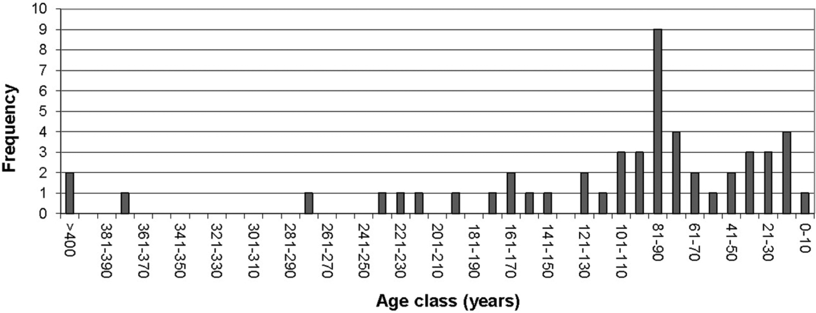
Distribution of estimated lichenometric age for flood deposits divided into 10 yr time periods.
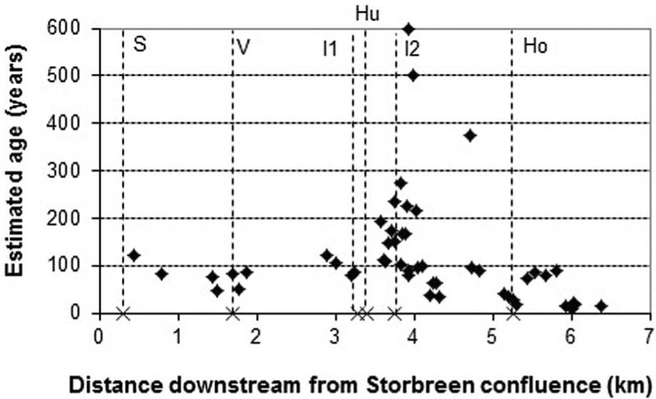
Scatterplot showing estimated age of flood deposit by lichenometry against distance downstream (tributary locations indicated by dotted lines; for label key see Figure 6).
Schmidt hammer exposure-age
Schmidt hammer mean R-values range from 48.8 to 65.1, with only six (11.4%) of flood deposits with values <55 and three (5.7%) <50. Estimated SHD ages of flood deposits based on the Jotunheimen curve place 44 (85%) flood deposits as <500 years old, while seven (13.5%) deposits are dated at 1000–6000 years old (Figure 9). The correlation of these SHD ages with the lichenometric ages is moderately strong (r = 0.60; p<0.05) although the SHD ages are much older than the lichenometric ages. Thus, the relatively old deposits are again associated with the Hurra/Illåe confluence zone. Furthermore, flood deposit height above the active channel and SHD age exhibit a strong positive correlation (r = 0.74; p<0.01). The corresponding relationship between flood deposit height and lichenometric age is weaker (r = 0.54; p< 0.05).

Distribution of age estimates of flood deposits based on Schmidt R-values (low-precision Jotunheimen curve of Matthews and Winkler, 2011, using data from Shakesby et al., 2006).
Vegetation development and soil depth
The vegetation succession on the flood deposits progresses from pioneer cryptogams (e.g. Rhaccomitrium and Stereocaulon), grasses and forbs (e.g. Poa, Cardaminopsis and Rumex) to dwarf willows (Salix spp.) and other dwarf shrubs (Empetrum, Arctostaphylos, Vaccinium, Betula nana and Salix spp.) culminating in birch (Betula pubescens) woodland, though woodland is generally absent because of grazing, particularly by heavy goat grazing around Geitsæter (Figure 1), leading to a mature grassland. Recently stabilised deposits at the distal sandur zone are dominated by the moss, Rhaccomtrium, but this is less common farther upstream, where pioneer grasses and forbs are characteristic. Some of the oldest deposits are characterised by a complete cover of dwarf shrubs or mature grassland.
Most flood deposits have only shallow soils (0–5 cm deep) consistent with soil development for up to 200–300 years (Figure 10). However, on some deposits near the Illåe confluence (GS1 and GS3), soils were up to 15 cm deep, which is consistent with development over thousands of years. Depth of soil development was correlated significantly with height above current river level (r = 0.53; p <0.05) and even more strongly with age estimates based on the Schmidt hammer (r = 0.73; p <0.01).
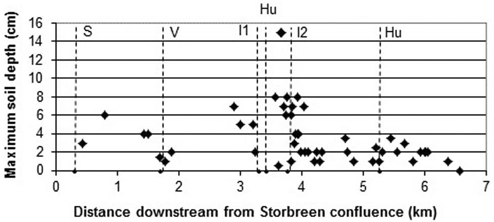
Depth of soil A (organic) horizon against flood deposit progressing downstream (tributary locations indicated by dotted lines; for label key see Figure 6).
Radiocarbon and OSL dating
In the terrace section at Ytterdalssæter I (Figure 11a), there is 0.5 m of fine-grained sediment overlying cobbles. The lowest of the three thin (0.5–1.0 cm) organic palaeosol horizons, at 35 cm depth, yielded an age of 150 ± 40 radiocarbon years BP (SWAN-552). This date indicates that the several flood layers higher in the section all post-date the ‘Little Ice Age’ glacier maximum of the mid-18th century, and that the basal cobbles may date from that maximum. The river-bank section at Ytterdalssæter II (Figure 11b) revealed six organic horizons, again interpreted as periods of surface stability in an aggrading floodplain. The lower two organic layers at 60 cm and 65 cm depth yielded ages of 510 ± 50 radiocarbon years BP (SWAN-554) and 1190 ± 40 radiocarbon years BP (SWAN-553), respectively. The latter, and probably the former, pre-date ‘Little Ice Age’ glacier activity, and all the overlying sediments must therefore reflect more recent flood activity.

Stratigraphic sections in terraces, showing with flood sediments with radio carbon age estimates at Ytterdalssæter (a) Pit 1; (b) Pit 2 (the two lowest organic layers have radiocarbon dates).
The river-bank section at Geitsæter (Figure 12) shows three massive flood layers of light grey silty sand that were dated using OSL. The upper layer (L1; depth 14–16 cm) yielded a pre-‘Little Ice Age’ age of 1090 ± 190 years. L2 (29–31 cm) and L3 (42–43 cm) yielded much older ages of 12,950 ±1540 years and 10,850 ±1050 years, respectively. Given the overlap in the confidence intervals of the latter two dates, they cannot be regarded as significantly different, which points to these sediments being deposited by melt water during Preboreal deglaciation.

Stratigraphic section in terraces, showing with flood sediments with OSL age estimates: at Geitsæter (diamond symbols indicate organic layers).
Palaeohydrological analysis
The minimum boulder-transport conditions for the largest boulder in each flood deposit against distance downstream are shown in Figure 13. Lowest unit stream powers for entrainment (ω) range from 119 W/m2 on the lower study reach (BG14; estimated date

Scatterplot showing estimated lowest unit stream powers for clast entrainment in flood deposit against distance downstream (tributary locations indicated by dotted lines; for key see Figure 6).
Historical records of floods
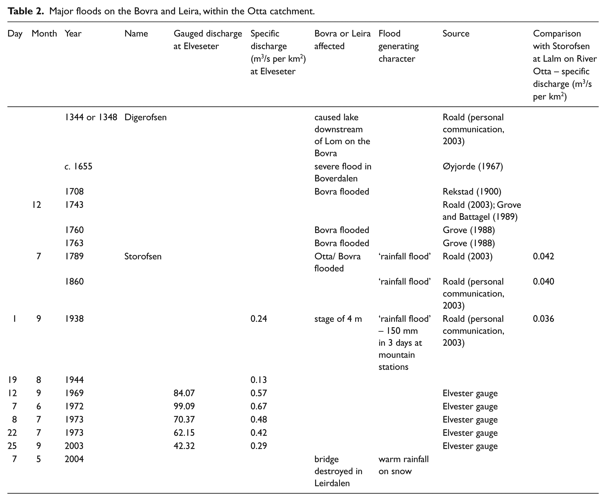
Table 2 shows major floods affecting the Bøvra catchment and its tributary the Leira identified from the gauged flow record and archival sources. The gauged flow record on the Leira is shown in Figure 14a. In the 17th and 18th centuries in Norway, significant numbers of contemporary damage reports (petitions for tax and land rent relief) were granted because of damage caused by hazards including floods (Grove, 2004). Extreme floods, generated by extreme rainfall, are known to have occurred on the Bøvra in
Major floods on the Bovra and Leira, within the Otta catchment.

(a) Gauged flow record on the Leira at Elveseter (1950–2001); (b) historical flood chronology for the River Leira plotted against known episodes of moraine formation.
When the timing of extreme floods on the Leira is plotted against the known episodes of ‘Little Ice Age’ moraine formation in Jotunheimen (Matthews, 2005), major floods appear to cluster towards the beginning and end of the phase of moraine formation (Figure 14b). Absence of an archival record of extreme floods is not, however, conclusive evidence of lack of floods in the study reach.
Discussion
Spatial variation in flood geomorphology
Down-valley variation in the character and distribution of coarse-grained flood deposits is strongly linked to the character and distribution of sediment supply. The lack of flood deposits on the upper Leira reflects limited coarse-grained sediment inputs as the glaciers upstream of the Storbregrovi confluence are small, and the main tributary carrying glacial meltwater (Tverrbyttbekkken) from the largest of these (Bjørnbreen and other small glaciers in Tverrbotn) passes through a small lake (Tverrbyttjorne), which prevents the downstream movement of coarse-grained sediment (Matthews et al., 2005). From the Storebregrovi confluence downstream, sources contributing sediment to the Leira for deposition during floods increase in quantity and diversity. The main sources of coarse-grained sediments comprise:
inputs from tributaries from glacierized catchments;
reworked toes of fans associated with these tributaries. The Illåe, in particular, possesses an extensive fan with high calibre sediment dating mainly from the early Holocene (McEwen, Matthews, Owen et al., unpublished data, 2011);
snow-avalanche deposits. A large avalanche impact mound occurs close to the Høgskridubreen confluence reflecting the excavation of bedload from the channel by avalanche activity (Liestøl, 1974), and providing evidence that snow-avalanches transport sediment onto the valley-floor (cf. Matthews and McCarroll, 1994; Owen et al., 2006);
limited inputs from bank erosion (especially in the sandur zone) and nival-fed tributaries with much smaller fans that are undercut by the Leira when in flood;
debris-flows, which mainly represent localised and episodic sources of sediment (Matthews et al., 1997, 1999, 2009), and are intermittently coupled with the fluvial system.
Flood deposits are therefore localised, mainly downstream of the glacially fed tributary confluences, and their associated fans. The extensive Storbeen glacier foreland provides the first substantial input of sediment. Two areas of flood boulder deposits with associated surfaces of different ages (Figure 4) occur immediately downstream of the Storbregrovi confluence. The relatively steep gradient, and partially engorged nature of this part of the valley account for the lack of more flood deposits. The most extensive field of flood deposits occurs downstream of the Illåe confluence. This reflects greater sediment inputs in the middle study reaches derived directly through coarse-grained sediment inputs from the Illåe and, to a lesser extent, the Hurra, and the undercutting of their outwash fans by the Leira when in flood. The Illåe has an alternative flood channel alignment over its fan that is activated in extreme floods, and it is likely that some deposits on the Leira floodplain relate to the merging of fan and floodplain.
Flood deposit heights above the current active channel are greatest in the middle reaches, reflecting the magnitude and relative extent of competent floods, with large discharge contributions from the Illåe and Hurra tributaries. This also provides evidence of vertical adjustment of the active channel associated with a trend of reducing discharge and sediment supply following glacier shrinkage after the ‘Little Ice Age’ maximum. Incision leading to the preservation of perched flood deposits is likely to have been accompanied by lateral migration and the reworking of earlier flood deposits (cf. Macklin and Lewin, 2003). Deposit heights are also greatest where local reductions in confinement of the Leira provide space for avulsed channel planforms during floods. It can be assumed that at least some larger accumulations of boulders (with relatively large boulders and competence requirements) more distant from, and standing a few metres above, the active channel have been transported and deposited by one discrete flood event. In contrast, flood deposits of lower height and closer to the current channel activity are likely to be composite forms that have been overwashed and/or reworked by more than one flood.
Chronology of flood deposits
The flood deposits range widely in age. According to lichenometry, two-thirds date from the 20th century, including most of those in the distal sandur zone and along the upper study reach (influenced by the Storebregrovi and Veslebregrovi confluences; Figure 8). The oldest flood deposits according to lichenometry are located in the Hurra/Illåe confluence zone. The oldest deposits are certainly pre-‘Little Ice Age’ according to lichenometry. Indeed, the SHD results suggest that some of these deposits are mid Holocene (4000–6000 years old) and even older ages are confirmed by the OLS dating results. It appears, therefore, that lichenometric dating is underestimating the age of the oldest flood deposits.
These apparently conflicting results suggest that the lichenometric dates are more sensitive to disturbance effects from recent floods, whereas the Schmidt-hammer dates reflect elements of the flood deposits that are more persistent. Overwashing by floods is more likely to erode crustose lichens from the boulder surfaces than to remove the weathering rinds that account for low Schmidt-hammer ‘R-values’. Thus, the Schmidt-hammer dates may be considered as estimates of when the flood deposits originated, while the lichenometric dates reflect when they were last disturbed by overwashing and abrasion. This explanation is substantiated by the strong positive relationship between flood deposit height above the active channel and estimated age according to SHD. In contrast, relationships between flood deposit height and estimated lichenometric age are much weaker and more complex. Even so, deposits <1.5 m above the active channel are nearly all <100 years old. Thus, boulders positioned relatively high above the channel seem to preserve low ‘R-values’ despite being subject to washover sufficient to remove lichenometric evidence of their true age.
Frequent overwashing and reworking of deposits on the valley floor appear to account for the sparsity of early-Holocene flood deposits. Nevertheless, the radiocarbon and OSL results from stratigraphic evidence clearly indicate that floods have occurred in Leirdalen since Preboreal deglaciation. Paradoxically, the oldest coarse-grained flood deposits mapped in Leirdalen occur near the most active confluences: all six of the oldest deposits according to SHD (Figure 9) are located within the Hurra/Illåe confluence zone. Survival of relatively old landforms in this location can be attributed to a combination of their height above, and distance from, the active river channel. At the opposite extreme, active erosion in the distal sandur zone has led to the local dominance of 20th-century deposits.
Stream power in relation to the chronology of flood deposits
Between the Storbregrovi confluence and the distal sandur zone, seven sedimentation zones can be recognised. These differ in character, including width of the potential area for lateral migration, the thresholds for sediment entrainment, and hence their frequency of reworking. In the sedimentation zone downstream of the Veslebregrovi confluence, for example, active braids and bouldery terraces occur but high thresholds for entrainment require high stream powers (883–1194 W/m2) for reworking earlier flood deposits. This is exacerbated by evidence of downcutting since the flood deposits were laid down. In contrast, the flood deposits on the distal sandur are associated with lower sediment size and minimum stream powers (128–222 W/m2) for sediment entrainment (Table 1; Figure 13). Here, aerial photograph evidence indicates a history of frequent channel avulsion and rapid channel switching during moderate to large floods. Over the late Holocene, the actively reworked area of the Leira within its sedimentation zones has contracted, most notably in the distal sandur zone, where at least two low terraces reflect the extent of active reworking in periods with higher discharge and sediment supply. The fact that few bars demonstrate later stages of the vegetation succession, along with the limited extent of soil development on most flood deposits, provides additional evidence of overwashing, if not reworking, of flood deposits during subsequent floods. However, although soil development proceeds much more slowly than the vegetation succession, the soils persist longer in the landscape in the face of overwashing and potential reworking by floods.
Flood deposits with the largest maximum sediment calibre (>1.0 m b-axis) and highest associated minimum unit stream powers have estimated lichenometric ages in the mid to late 19th century (1852, 1854, 1882 and 1898; Figure 15a,b). This suggests either higher competence floods or greater availability of coarser sediment at these dates or both. Flood deposits dated earlier or later are of lower stream power, suggesting either that flood magnitudes have since decreased in competence or that the availability of coarse sediment supply has declined, or both (cf. Macklin et al., 1992).

(a) Scattergraph showing maximum b-axis of flood deposit against estimated age of deposition using lichenometric dating; (b) scatterplot showing unit stream power against estimated date of deposition using lichenometric dating (both Central Jotunheimen curve, Matthews, 2005).
Linking flood deposits to the historical record of flooding, glacier variations and climate
The main methodological issues in linking the lichenometric age of the flood deposits to the historical record of flooding are: (1) the inherent precision and accuracy of lichenometric dating; (2) additional errors introduced by application to flood deposits; (3) the efficiency of the flood overwashing process in eroding lichens from the boulder surfaces; and (4) possible inhibition of lichen growth and underestimate of surface age due to vegetation overgrowth. The environment for lichen growth will vary with the character of the flood deposit, including its height above the channel, the extent of snow cover, and frequency of inundation. Floodplains, despite episodic inundation, are relatively dry, exposed sites but boulder-rich flood deposits have much in common with moraines in terms of topography and the surface texture of boulders. We consider it likely, therefore, that dating errors associated with the application of lichenometry to the flood deposits are similar to the inherent errors of 10–20 years expected from its application to moraines in this region of Jotunheimen (Matthews, 2005). This is consistent with the differences in estimated age between the two different approaches to lichenometric dating employed in this study.
The evidence for the importance of overwashing and reworking of the flood deposits is clear but the efficiency of this process in eroding lichens in this environment is unknown. If the process was 100% efficient, then the largest lichens occurring on each flood deposit would provide a close estimate of when it was last inundated. The differences between the age estimates from lichenometry and the SHD ages suggest that the process is much more efficient at removing lichens than at removing weathering rinds. However, the fact that many deposits located at similar heights above the active channel appear to be related to different flood events (Figure 16), suggests inefficiency consistent with lichen survival of many overwashing flood events. This in turn suggests that the lichenometric dating is likely to be indicative of the timing of several recent flood events, rather than merely the last one.

Flood deposit height against estimated date of flood deposit using lichenometric dating (Central Jotunheimen Curve, Matthews, 2005).
The above considerations make it challenging to relate individual flood deposits to specific flood events. With this caveat, the lichenometric dating evidence indicates that up to one-third of the flood deposits may relate to the extreme
The ‘Little Ice Age’ had implications for both discharge regime and sediment supply on the mainstem Leira. The period including the glacier build-up to, and initial retreat from, the ‘Little Ice Age’ glacier maximum (
The hydrological implications of the ‘Little Ice Age’ glacier expansion episode and other similar neoglacial events, which were driven primarily by an increase in winter precipitation but also by lower summer temperatures (Matthews et al., 2005; Nesje et al., 2001a, 2008b), are not entirely clear. Periods of relatively high flood frequency occurred at various times during the Holocene (Bøe et al., 2006; Nesje et al., 2001b; Støren et al., 2008) and these show some similarities with phases of glacial growth and enhanced colluvial activity (Matthews et al., 2009; Vasskog et al., 2011).
Although the climatic drivers are not the same, it is likely that there is a connection with the frequency of severe floods and colluvial events (driven by the frequency of extreme storms) and glacier advances (driven by trends in winter precipitation and summer temperatures) via the general circulation of the atmosphere and weather patterns (cf. Bakke et al. 2008; Matthews et al., 2009). For example, after the extreme flood of 1972, debris flow activity is also known to have occurred in Leirdalen in 1974 and 1976 (Matthews et al., 1997, 1999; Shakesby and Matthews, 2002).
Sensitivity, persistence and resolution of the geomorphological record of floods
The lichenometric and SHD dating of coarse-grained flood deposits, supplemented by OSL and radiocarbon dating of fine-grained deposits and associated palaeosols, reveal an incomplete geomorphological record of floods in this alpine environment. Nevertheless, evidence of extreme floods has persisted in Leirdalen since the early Holocene, and there is evidence that the geomorphological record exhibits sensitivity in relation to glacier and climatic variations. In the above discussion, the fragmentary nature of the record is attributed primarily to overwashing and reworking of the valley-floor landscape by frequent floods. This disturbance regime severely affects the persistence of the evidence.
Frequent overwashing and erosion of lichens restricts the usefulness of lichenometry for flood reconstruction to little more than the last 100 years in this environment. Lichens older than this are relatively rare on the flood deposits. Occasional very large lichens up to about 250 mm in diameter indicate the persistence of older flood deposits dating from well before the ‘Little Ice Age’ maximum and possibly back into the ‘Mediaeval Warm Period’, but lichen survival rates are too low to enable reconstruction of a geomorphological record of flooding. On stable, undisturbed surfaces in Jotunheimen and elsewhere in southern Norway, such as moraines, lichenometry has temporal range of at least 500 years, possibly 1000 years (Matthews, 1994; Matthews and Trenbirth, 2011). Combined with estimated error limits for lichenometric dating in the order of ±10–20 years (a temporal resolution that prevents the identification of individual flood events) disturbance by floods therefore enables only recent decadal-scale variations in flood frequency to be detected. However, comparison of the historical record of floods with the lichenometric chronology of the flood deposits (Figure 17) shows that this resolution is compatible with the sensitivity of the geomorphological record to recent decadal- to century-scale glacier and climatic variations.
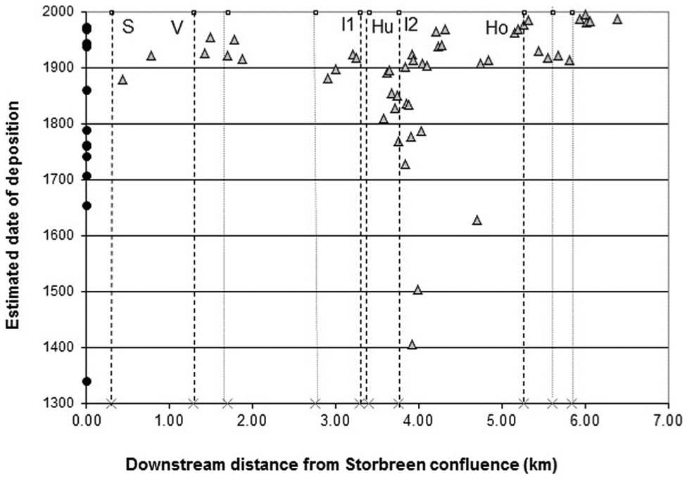
Composite diagram showing estimated date of deposit using lichenometry against distance downstream, with timing of known extreme floods (indicated as black dots on y-axis). Major and minor tributary locations are indicated by dotted lines; for label key see Figure 6).
Removal of more resistant weathering rinds by floods, combined with the inherent limitations of low-resolution SHD, also restricts the usefulness of SHD in this environment. The possible accuracy of this technique is in the order of ± 500–1000 years (Matthews and Owen, 2008; Matthews and Winkler, 2011). With survival of some rinds on surfaces originating up to 6000 years ago in the mid Holocene, it appears that the geomorphological record has some potential for identifying millennial-scale variations in flood frequency. However, low persistence of the geomorphological record, combined with the limited resolution of available dating techniques, means that the decadal-scale sensitivity of the record can only be approached over recent centuries.
Conclusions
(1) Coarse-grained flood deposits on the valley floor of Leirdalen vary significantly in character and calibre downstream but there is no simple downstream fining. Key coarse-grained sediment sources are the glacierized tributaries.
(2) According to lichenometric dating, the flood deposits predominantly date from the ‘Little Ice Age’ or later and a significant percentage (>60%) date from the 20th century. However, the competence of floods that generated these flood deposits was higher in the 18th and 19th centuries than in the 20th century.
(3) Evidence from comparatively low-resolution Schmidt-hammer exposure-age dating (SHD) supports a high percentage of relatively young deposits but has also enabled the identification of a few substantially older flood deposits dating from the mid Holocene. Furthermore, optically stimulated luminescence (OSL) dating of subsurface fine-grained flood layers indicates that some deposits originated in the early Holocene, following Preboreal deglaciation.
(4) Lichenometry also enabled the older surfaces to be identified but produced much younger ages than SHD. These apparently conflicting ages imply that the flood deposits are overwashed and reworked frequently by the Leira; and that relatively fragile lichen thalli are eroded more easily than relatively robust weathering rinds on boulders in the relatively old deposits. Extensive recent flood disturbance was also confirmed by the stage of vegetation succession, and the limited soil cover on the landforms.
(5) The geomorphological record of floods is therefore fragmentary and incomplete. Although some elements of the coarse-grained flood deposits have persisted at least since the mid Holocene, other elements are highly sensitive to disturbance by later floods. The flood landforms in the valley floor landscape exhibit therefore a generally low level of persistence. Potential for persistence is greatest near the major tributary confluences, and where large-calibre flood deposits are located relatively high above the active channel. The preservation potential of flood deposits decreases downstream where distance from glacial sediment sources increases, where the calibre of clasts is smaller, and pre-existing flood deposits can be reworked by lower flood magnitudes.
(6) Links were established between the lichenometrically dated flood deposits and the historical flood record, most of the flood deposits being dated to phases of relatively frequent major floods in the 18th century (including the ‘Storofsen’ of
(7) The phases of more frequent floods over the last ~350 years correspond with the multidecadal-scale build-up of glaciers to their ‘Little Ice Age’ maxima and the rapid glacier retreat of the 20th century, respectively. Limited correspondence was found between historical floods and the subdecadal-scale glacier variations since the ‘Little Ice Age’ maximum.
(8) The overall conclusion is that despite generally low persistence, the geomorphological record of floods in Leirdalen is sensitive to decadal- to century-scale climatic variations over the last few centuries of the late Holocene. This, in turn, suggests that changes in the general circulation of the atmosphere led not only to changing winter and summer climate (affecting the glaciers) but also to changes in the frequency of extreme storms (potentially generating floods).
(9) Future research could focus on testing these conclusions in neighbouring valleys, and on the generality and synchroneity of response between catchments. Further work is also required on the relationship between episodic flood deposition on mainstem rivers, and sediment inputs from glacierized tributaries.
Footnotes
Acknowledgements
The input of Lars Roald (NVE) in reconstructing flood histories is gratefully acknowledged. Jamie Roxburgh and Paul Satchell, UWE, drew up the diagrams. Radiocarbon dating was carried out in the Swansea Radiocarbon Dating Laboratory by Dr P Quentin Dresser and OSL dating in the University of Gloucestershire Luminescence Laboratory by Dr Phillip Toms. This paper is Jotunheimen Research Expeditions, Contribution No. 183.
Funding
The authors wish to thank the BGRG for a small research grant (to LJM) in support of this work.