
Abstract
A 19 m long sedimentary record retrieved in Lake Aydat (French Massif Central) covers the last 6700 yr at a high resolution. A multiproxy approach (density, magnetic susceptibility, XRF, Rock-Eval, pollen and non-pollen palynomorph analyses and a historical archives study) was used to characterise and propose a model of sedimentation. The high deposition rate results from the combined effects of the high suspension load of the river, autochthonous production and the narrow shape of the incised fluvial valley dammed by a lava flow c. 8550 years ago. Two contrasted periods (6700±200 to 3180±90 cal. BP, and 1770±60 cal. BP to present) were characterized. The lower unit (mid Holocene) displays a fine and regular lamination and holds a single, major, flood deposit. This unit is capped by an erosive mass-wasting deposit triggered c. 1770±60 cal. BP. The upper unit (late Holocene) is made of organic-rich and fine-grained faintly laminated sediment, with numerous interbedded flood deposits and diatom blooms. The sedimentation was principally controlled by climatic forcings until c. 1100 cal. BP, accompanied by detrital events linked to human activities around the lake. Then, a more detrital input attested by numerous and recurrent flood deposits can be linked to the intensification of a persistent anthropogenic impact on the catchment. Two phases of lake eutrophication are highlighted: 1200–1130 cal. BP, as a result of increased anthropogenic pressure, and the current phase that could have started c. 150 cal. BP.
Introduction
Anthropogenic activities are now universally considered as having a strong impact on natural systems (e.g. Dearing, 2006) and on the whole terrestrial environment (Intergovernmental Panel on Climate Change (IPCC), 2007), including geological processes (e.g. Crutzen, 2002; Wilkinson, 2005). It is therefore crucial to comprehend the complex inter-relationships linking societies, climate and environments. Unravelling such interactions entails studying natural records, which provide information that allows the consequences of current global change to be anticipated (Costanza et al., 2007). Among various natural archives having a well-proven preservation potential, lacustrine sediments can provide high quality information. Like marine pelagic sediments, they generally constitute continuous records, but in contrast to the former they can deliver local information about the natural (e.g. climate, topography, vegetation) and anthropogenic conditions prevailing at the limited spatial scale of a drainage basin (e.g. Battarbee and Bennion, 2011; Zolitschka and Ariztegui, 2007). The mid-altitude mountainous configuration of the French Massif Central, at the boundary of oceanic and continental climatic influences, confers on this region a relatively high sensitivity to climatic changes coupled with marked anthropization. However, so far, only a few studies have been devoted to the interactions between the environment, humans and climate in this region, with the notable exception of its northern plain, the Limagne (e.g. Ballut, 2000; Fourmont et al., 2009; Macaire et al., 2010). Earlier palaeoenvironmental studies performed on the mountainous part, the Chaîne des Puys, focused mainly on vegetation history and tephrostratigraphy (de Beaulieu and Goeury, 1987; Juvigné et al., 1988). Multiproxy analyses on Auvergne mountain areas combining palaeoecology, archaeology and historical sources still remain scarce (e.g. Ballut et al., 2012; Michelin et al., 2001; Miras et al., 2004; Prat, 2006; Surmely et al., 2009), especially when compared with regions such as the NW Alps, where lacustrine archives are numerous and have been extensively studied (e.g. Arnaud et al., 2005; Chapron et al., 2002; Debret et al., 2010; Leroux et al., 2008; Magny, 2004). The Massif Central did not benefit from the same interest, although it contains a notable number of lakes, including crater lakes that are remnants of its Tertiary to Quaternary – including Holocene – volcanic activity. While the sediment infill of some of these lakes has been investigated for various purposes (e.g. to track erosion fluxes or highlight natural hazards: Chapron et al., 2010; Gay and Macaire, 1999; Macaire et al., 1995), to date no high-resolution multidisciplinary study of a long-term lake sediment record has been conducted in this region. The history of human occupation in the surroundings of Lake Aydat has already been explored (Miras et al., 2004) and thus represents a suitable target to partly fill this gap. Moreover its recent sedimentation and (bio)chemical characteristics have recently been studied to apprehend its current eutrophic functioning (e.g. Alfonso, 2000; Michard et al., 2001; Ogier et al., 2001; Sarazin et al., 1992, 1995; Stefanova and Disnar, 2000). In this perspective, this paper reports the results of the investigations carried out on a 19 m long Lake Aydat sedimentary sequence that covers the last 6700 years. The establishment of an age–depth model and comparison with other studies are used to highlight climatic and anthropogenic contributions to the sedimentary signal, approached through density, magnetic susceptibility (MS), x-ray fluorescence spectrometry (XRF), organic bulk analyses, pollen and non-pollen palynomorph (NPP) analyses and a study of historical archives.
General setting
Lake Aydat (N 45°39.809′/E 2°59.106′) is located in the French Massif Central, c. 25 km SW from Clermont-Ferrand, at the southern boundary of the Chaîne des Puys volcanic range (Figure 1), where it forms a plateau sharply incised by V-shaped valleys. The lake is at an altitude of 837 m a.s.l. and originates from the damming of the Veyre River by a basalt flow dated from 8551± 400 cal. BP that issued from the Puy de la Vache and Puy de Lassolas volcanoes (Boivin et al., 2004). The lake surface is 6 × 10⁵ m2. Its water volume is of c. 5.2 × 10⁶ m3, with an average depth of 7 m and a maximum depth of 15 m. The mean residence time of the water is c. 7.5 months (Michard et al., 2001). The lake is eutrophic and is mainly fed from the west by the Veyre River (75%), completed by a lateral supply through the shores and direct precipitation (25%). The river constitutes the main outlet for the waters (85%), the rest (15%) percolating through the basaltic flow (Bouchet, 1987). An earlier study estimated the recent (last 50 years) sedimentation rate at c. 0.46 cm/yr in the deepest part of the basin (Sarazin et al., 1992). The lake’s catchment is located upstream the Loire River basin and is mainly fed by precipitation brought from the Atlantic Ocean depressions. Its surface is c. 30 km2 and extends from 837 m a.s.l. to 1300 m a.s.l. (west, top of the volcanoes; Figure 1). It develops on a plutonic and metamorphic substratum (mainly granodiorites), partially covered by Lateglacial to Holocene volcanic deposits (Boivin et al., 2004). Nowadays, the catchment is mainly covered by grasslands and pastures, and by human-sowed secondary forests (principally coniferous: Picea sp.), mainly on the top of volcanoes. Andisols constitute the typical type of soil covering the catchment.
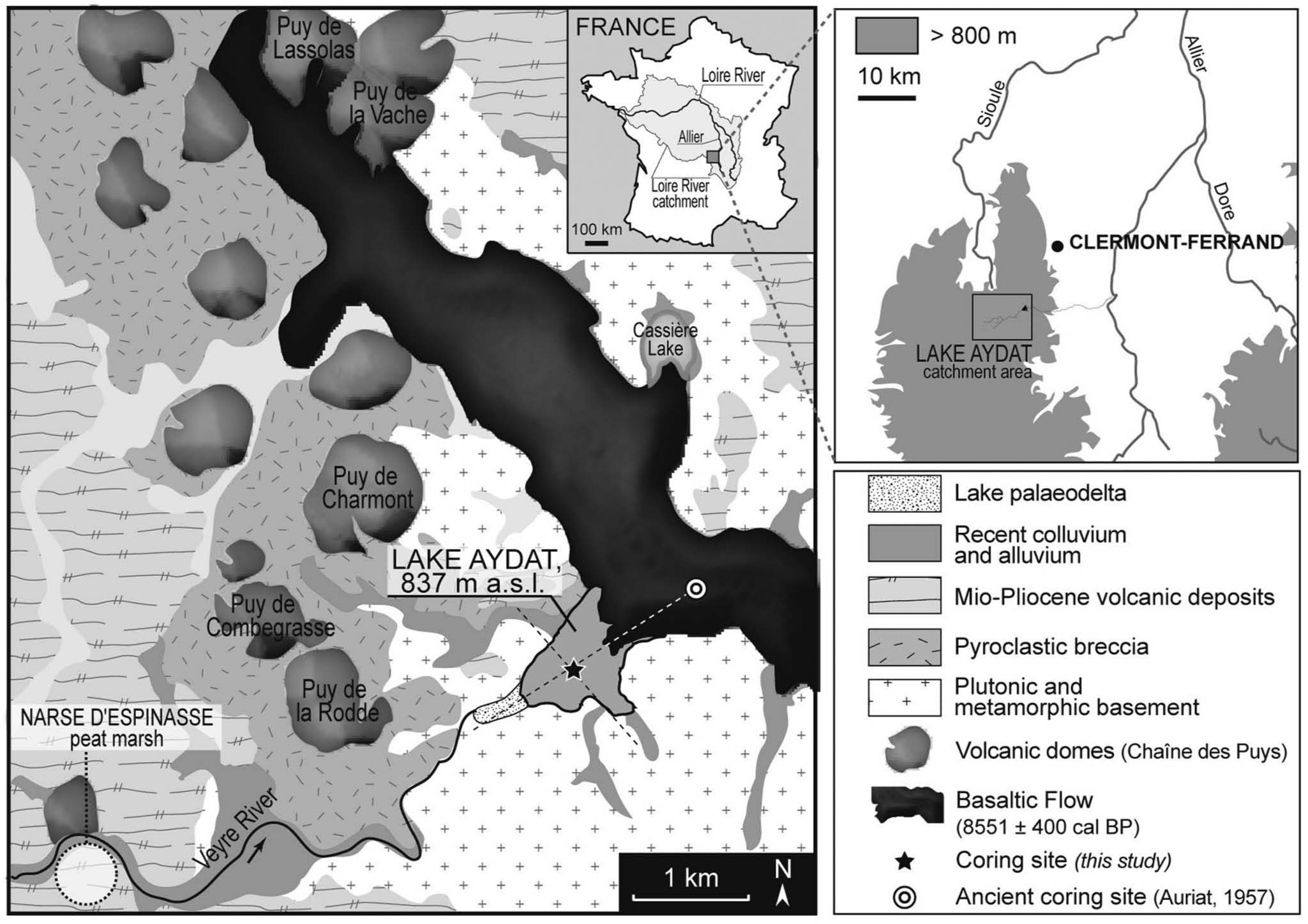
Location of Lake Aydat and its geological setting (after Boivin et al., 2004). Dashed lines locate topographic profiles presented in Figure 2.
Material and methods
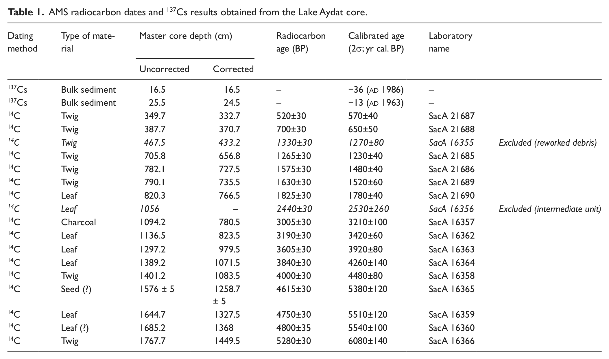
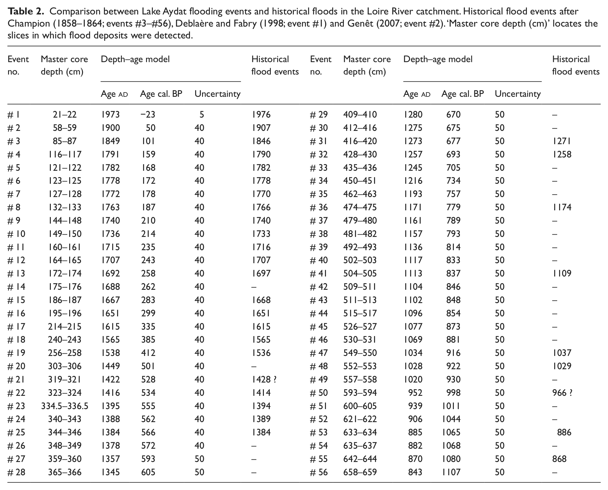
A high-resolution seismic reflection survey, carried out prior to the coring, failed to reveal the detailed structure of sedimentary deposits because of a high content of methane, but confirmed previous bathymetric measurements (Figure 2a, b). Accordingly, the coring site was chosen in the central and deepest part of the basin, close to the Veyre River delta. A continuous sequence (AYD09) was retrieved in 2 m and 3 m long sections at 14.5 m water depth (Figure 1) with a UWITEC coring platform. A set of core sections at two nearby locations allowed the recovery of a 19 m long sedimentary record (Figure 3), once the core sections had been opened, described and correlated based on the identification of key lithological horizons on each core section. The core was divided into 1 cm thick slices for analytical purposes. The chronology of the top 20 cm of the sequence is based on 137Cs and 241Am measurements (Table 1; Figure 4). Twenty-five samples from the top of the core were measured by ultra-low background, high-efficiency gamma-spectrometry at the ‘Laboratoire Souterrain de Modane’ as described in Reyss et al. (1995). 137Cs and 241Am were measured together with 210Pb and 7Be. Seventeen AMS radiocarbon dates distributed over the core, based on leaf and wood fragment analyses and obtained at the Laboratoire de Mesure du Carbone 14 (Gif-sur-Yvette, France) and calibrated (2σ) using CalPal Online (Danzeglocke et al., 2011; Table 1; Figure 3) constitute the base of the whole core chronology. The scarcity of datable organic material in the top 7 m was counterbalanced by the detection of numerous millimetre- to centimetre-scale flood deposits (Mulder and Chapron, 2011) that were correlated with historically described flood events that are well documented in the Loire River catchment and allowed validation of the age–depth model (Champion, 1858–1864; Deblaère and Fabry, 1998; Genêt, 2007; Table 2; Figure 3; see ‘Background sedimentation and origin of detrital inputs’ for the identification of flood deposits). Loire River floods mainly originate from its upstream part (i.e. Massif Central), as a result of numerous factors (e.g. hydrologic conditions, slopes, impermeable geology; Genêt, 2007), so they can be reliably compared with those recorded in Lake Aydat sediments. MS and XRF-based element composition were measured following a step of 1 cm using a Bartington MS2E point sensor on a Geotek Multi-Sensor Core Logger System (MS; Chrono-Environnment, Besançon, France) and a Avaatech Core Scanner (XRF; Environnements et Paléoenvironnements Océaniques et Continentaux, Bordeaux, France), respectively. Density was appraised by continuous measurements using a Hologic densitometer (dual energy x-ray absorptiometry; Institut de Prévention et de Recherche sur l’Ostéoporose, Orléans, France), and SEM pictures were acquired from a LEO, Gemini, Zeiss DSM 982. Bulk organic matter (OM) analyses were carried out with a Rock-Eval6 (RE6) on c. 60 mg of dried and crushed sediments. The Rock-Eval parameters used in this study are Total Organic Carbon (TOC, %), Hydrogen Index (HI, mg hydrocarbons/g TOC), and Oxygen Index (OI, mg CO2/g TOC; Espitalié et al., 1985; Lafargue et al., 1998). Samples were taken every 2.5 cm for pollen and non-pollen palynomorph (NPP) analysis, and prepared using standard procedure (Faegri and Iversen, 1989). Minimum counts of 500 dry land pollen grains per sample were made. Pollen and NPP values were calculated as the percentage of total land pollen excluding Cyperaceae, fern spores and aquatic plants. As this paper aims at dealing with Holocene sedimentation, pollen and NPP assemblages are interpreted here in broad terms with added curves presenting the Arboreal Pollen/Total Pollen (AP/T) ratio, crops, Anthropogenic Pollen Indicators (API) including pollen taxa indicative of human impact (Behre, 1981) and those underlined by the modern pollen assemblages study carried out in the Massif Central (Miras, 2009) and coprophilous fungi that are useful to assess local grazing activity (Ejarque et al., 2011; van Geel et al., 1989).
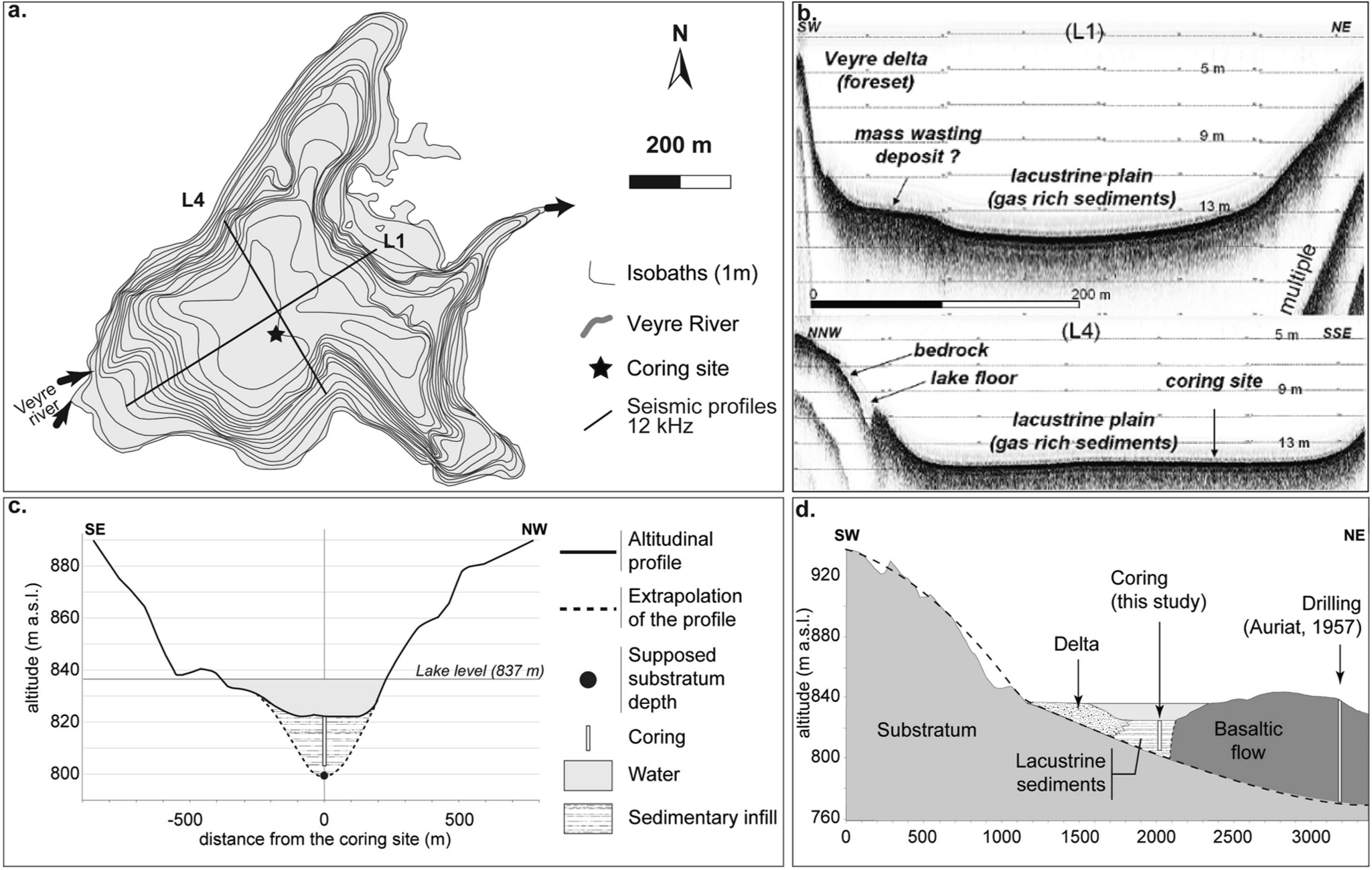
(a) Bathymetric map of Lake Aydat and location of the coring site and of the seismic profiles shown in (b). (c) Altitudinal profile transverse to the lake and extrapolation showing the morphology of the valley (location: see Figure 1). (d) Schematic representation of a longitudinal profile, from the palaeodelta to the coring in the basaltic flow. Dashed line: approximate outline of the supposed location of the substratum of the lake, estimated from the river profile tendency.
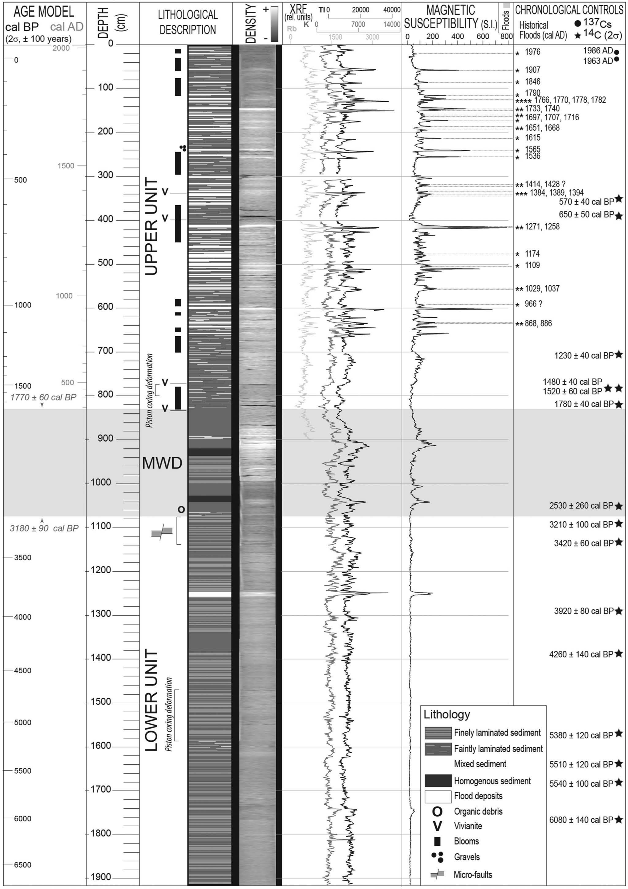
Core description, lithology and physical parameters (density, MS, and XRF – Rb, Ti, K), stratigraphic location of the 137Cs and 14C ages and of the historical floods. Mass wasting deposit (MWD) is presented as it appears in one of the two twin cores. Only the noteworthy diatom blooms are figured.
AMS radiocarbon dates and 137Cs results obtained from the Lake Aydat core.
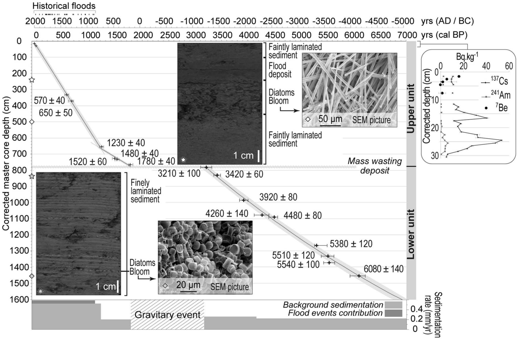
Age–depth model, correlation with historical floods, sedimentation rates and sedimentological units. Stars and diamonds locate the depths of the pictures presented. 137Cs, 241Am and 7Be of the top of the core are provided on the right.
Comparison between Lake Aydat flooding events and historical floods in the Loire River catchment. Historical flood events after Champion (1858–1864; events #3–#56), Deblaère and Fabry (1998; event #1) and Genêt (2007; event #2). ‘Master core depth (cm)’ locates the slices in which flood deposits were detected.
Results
Background sedimentation and origin of detrital inputs
Ogier (1999) showed that sediments of the Veyre River are rich in Rb, Ti and K that can thus be used as markers of detrital inputs. This characteristic is also attributable to density and MS measurements in the core that highly correlate with these three elements (Figure 3). Any increase in these physical parameters inside a rapidly deposited layer (RDL) can therefore be considered as resulting from an amplification of the erosion flux, and thus to hyperpycnal flood events, as expanded by Mulder and Chapron (2011). The siliceous endogenic phase is the main constituent of the background sedimentation, half of the dissolved Si that comes into the lake being finally stocked as opal A in diatom frustules (Ogier, 1999; Sarazin and Devaux, 1991).
Sedimentological features
Based on sedimentological features, the record is divided into three main units (Figures 3 and 4):
The lower unit (1076–1914 cm depth) shows laminations consisting of alternating beige diatom blooms and dark detrital levels. Despite these two major sources the sediment is rich in OM (generally 8–10% TOC), with moderate HI and OI values (250–300 mg HC/g TOC and 100–150 mg O2/g TOC, respectively). It also contains one major flood deposit, the thickest one of the whole core (1248–1254 cm depth). The background MS value of this unit is mostly < 10 × 10−5, but can reach up to 40 × 10−5 S.I., and is highly correlated to XRF (Ti, K) measurements. In the upper part, laminae are noticeably affected by microfaults, thus attesting to a destabilization of the sediment after deposition.
The upper unit (0–829 cm depth) contrasts strongly with the lower one. It is constituted by a background of dark and faintly laminated OM-rich sediment (3–5.5% TOC) also showing moderate HI and OI values (200–300 mg HC/g TOC and 100–200 mg O2/g TOC, respectively), frequently interrupted by diatom blooms and flood deposits (1–5 cm thick; Figure 3). The latter are darker and characterized by high density and high MS (up to 800 × 10−5 S.I.), reflecting increased erosional inputs from the catchment (Section ‘Background sedimentation and origin of detrital inputs’). Background MS mostly ranges between 40 and 100 × 10−5 S.I., and shows the same trends as the Rb, Ti and K ones.
Between the two previous units (829–1076 cm depth), the correlation between the two twin cores was impossible. 1 m of the sedimentary sequence appeared exactly repeated in only one of the twin cores, while particular MS fluctuations were unique to the other one (this one illustrated in Figure 3). Naked eye observation allowed the distinction of disturbed layers at the boundaries. Combined with the presence of the microfaults at the top of the lower unit, these indices were interpreted as a mass wasting deposit (MWD; Mulder and Cochonat, 1996) that reworked c. 2.5 m of sediment. Consequently, this unit is not discussed further here.
Depth–age model and accumulation rate
Owing to its short half-life (53 days), the detection of 7Be in the uppermost layers of the core attests to a well-preserved sediment interface (Figure 4). From the artificial radionuclides profile (Table 1, Figure 4; Appleby, 2000) two events were dated: (1) the
Pollen data
Pollen data that were obtained from background sediment samples (i.e. without flood deposits; Figures 5, 6) show that Arborean pollen are largely dominant throughout the lower unit (AP/T generally > 90%; Figure 5). Pinus sharply decreases as Fagus increases, from c. 5600 cal. BP. Evidence of anthropogenic activities are recorded through indices of crops and coprophilous fungi. A similar pattern is observed at the base of the upper unit (Figure 6), but crop pollen occurrences become continuous. AP/T suddenly decreases from 1500 cal. BP, when anthropogenic indicators (API) – Poaceae, crops and coprophilous fungi – increase sharply. 150 cal. BP clearly signs the renewal of Pinus, to the detriment of crops and coprophilous fungi indicators. These general trends follow those observed through physical (MS, density, XRF) and bulk geochemical (TOC, HI, OI) analyses, and allowed the recognition of different phases covering the whole lower unit, and four in the upper one (1770–1500 cal. BP, 1500–1200 cal. BP, 1200–150 cal. BP, 150 cal. BP–present).
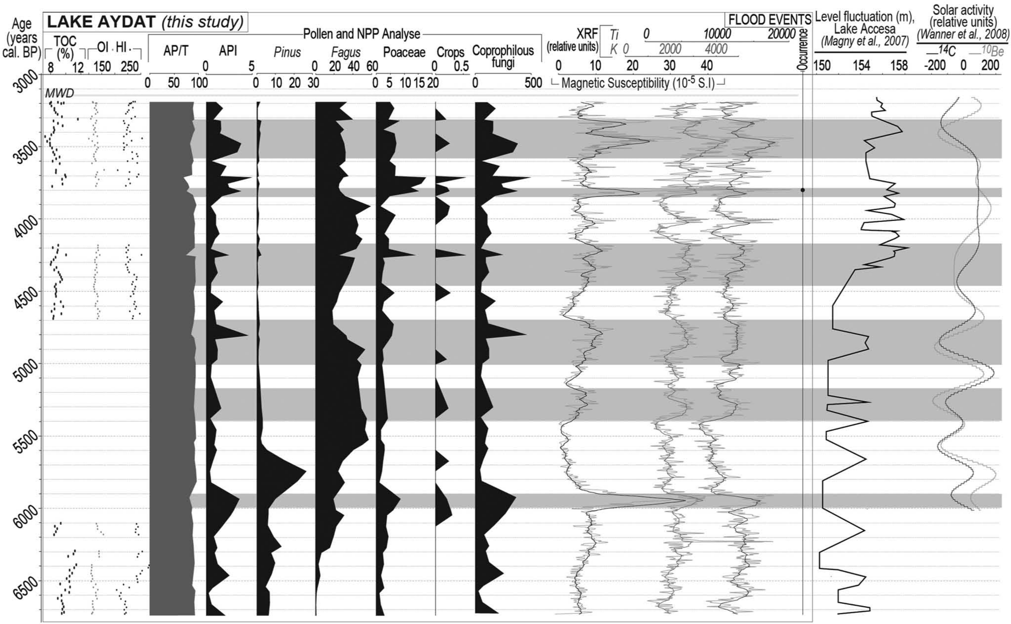
Background signal of the lower unit – MS, TOC, OI, HI, pollen and NPP analyses, compared with solar activity (Wanner et al., 2008) and Lake Accesa level fluctuations (Magny et al., 2007). Phases of higher detritism are indicated by the horizontal grey strips. MWD: mass wasting deposit.
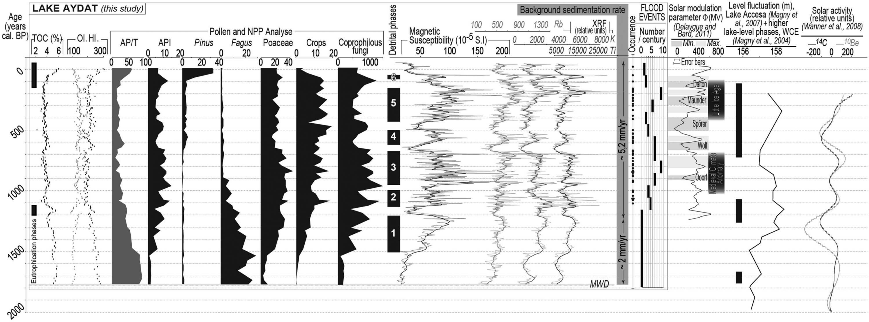
Background signal of the upper unit – MS, TOC, OI, HI, pollen and NPP analyses, occurrence and frequency of flood events and eutrophication phases compared to West-Central European (WCE) lake-level records (Magny, 2004), Lake Accesa level fluctuations (Magny et al., 2007), and solar activity (Delaygue and Bard, 2011; Wanner et al., 2008). MWD: mass wasting deposit.
Discussion: Climatic and anthropogenic influences on the sedimentary record
Rb, Ti and K signatures recorded in the sediments come from the erosion of andisoils, themselves deriving from a minor contribution of the granodioritic substratum added to the material originating from volcanic formations (Ogier, 1999). This detrital imprint is recorded in flood deposits, and to a lesser extent in the background sedimentation. Natural/anthropogenic contributions to the sedimentary record were evaluated by comparing the background detrital input (i.e. MS without instantaneous deposits) and pollen data with previously studied climatic and anthropogenic records, as shown in Figures 5 and 6. Local human impact was mostly estimated from pollen and NPP analyses acquired during the current study, compared with the former high-resolution palynological and multidisciplinary study performed on the 5000 yr long record of the ‘Narse d’Espinasse’ (Miras et al., 2004), a peat marsh located in the lake’s catchment (Figure 1), that certainly constituted up to now one of the most complete palaeoenvironmental Holocene records for the whole Massif Central.
Lower unit (6730–3200 cal. BP)
All along this unit the OM contents appeared to remain stable both from a quantitative (TOC: 8–10%) and qualitative point of view (HI and OI, 250–300 mg HC/g TOC and 100–150 mg O2/g TOC, respectively). These geochemical characteristics sign an OM classically derived indistinctly from terrestrial plants (Meyers and Lallier-Vergès, 1999) and from diatoms which appear to produce rather similar HI and OI values (Ariztegui et al., 2001). Throughout this unit, six phases of relatively higher background detrital input are depicted on the basis of MS variations (Figure 5), in particular on long-term increasing tendencies and more short-term but highly significant increases in MS. These major features seem to coincide with the general pattern of the climate-driven Lake Accesa level evolution (Tuscany, North-Central Italy, reflecting the whole West-European pattern; Magny et al., 2007), and more generally with periods of lower solar activity (Wanner et al., 2008), the latter inducing climatic variations (with cooler and more humid conditions) considered to favour enhanced soil erosion on catchments (Arnaud et al., 2005; Debret et al., 2010). However, this comparison is not sufficient to explain the amplitude of variation of the detrital input observed at c. 5900 cal. BP, which is much greater than the other ones in this unit, or the 3800 cal. BP increase of detrital input that is not correlated with a climatic event. Other factors must be invoked, such as human impact that can be assessed from pollen and NPP analyses (Figure 5). At c. 6000 cal. BP, the slight decrease in the AP/T ratio, associated with an increase in herbaceous taxa and dung-related fungi, evidence the first, moderate woodland opening accompanied by local grazing activity. Together with a favorable climatic context, these putative slight human impacts likely influenced detrital inputs. The corresponding catchment occupation was most probably occasional, as pollen and NPP indices of abandonment are observed immediately after (renewal of heliophilous trees such as Pinus, decline of coprophilous fungi). This lapse of time is immediately followed by a well-known abrupt climate change, dated to c. 5600 cal. BP (Magny et al., 2006). This change is not recorded by an increase of detrital input in Lake Aydat but pollen clearly attest to the development of a beech grove, characteristic of a cooler and wetter climate (de Beaulieu et al., 2006). A higher human pressure is recorded in the catchment by pollen and NPP data (fall of Fagus, increase of Poaceae and API) between c. 4900 and 4600 cal. BP. This coincides with a high MS value denoting stronger detrital inputs. The latter that were favored by a higher erodibility of the soils subsequent to the change of vegetation, are also in agreement with previous work by Miras et al. (2004) which showed an important phase of fire-clearing at this period. The major flood event of the whole core is evidenced at c. 3800 cal. BP. Its thickness (6 cm), reflecting its intensity, is unusual compared with the others. This event happened during a period of increasing human landscape management (c. 3900–3500 cal. BP). Indeed, a marked woodland opening is associated with an extension of grassland and heliophilous taxa during this period, also described in the neighbouring site of the Narse d’Espinasse (Miras et al., 2004). The rise of API is associated with a significant increase in dung-related fungi, especially Sporormiella, attesting to the local presence of animals (Davis and Shafer, 2006). This points to the highly probable role of anthropogenic activities as a trigger of this flooding event. Then, a lesser anthropogenic pressure (revealed by a decrease in anthropization indices and a renewal of the forests, c. 3500–3200 cal. BP) on the catchment allowed us to better distinguish a climatic imprint during the last phase of higher detrital input.
Thus, from the beginning of the sedimentary record to the Final Bronze period, detrital input variations were already under the joint influence of climate and of human activities, the effects of the latter being indeed punctually perceptible from the middle Neolithic (c. 5900 cal. BP).
Upper unit (1770–0 cal. BP): General overview
MS variations in the upper unit enabled six phases of higher background detrital input to be distinguished, at c. 1510–1210 cal. BP, c. 1130–1000 cal. BP, c. 950–670 cal. BP, c. 620–500 cal. BP, c. 430–150 cal. BP, and c. 90–50 cal. BP (Figure 6). The MS values reached during these events are two to four times higher than in the lower unit. These phases of high detrital input coincide neither with known periods of climatic variations, nor with general trends of level fluctuations in Western Central Europe (Figure 6; Magny, 2013; Magny et al., 2007). Conversely and strikingly, phases of lower detrital input occur when solar activity is low – such as during Wolf and Spörer (Delaygue and Bard, 2011) – that are supposedly characterized by enhanced erosional fluxes (Magny, 2004, 2013). This inconsistency prompted us to invoke factors other than climate to explain these particular variations in detrital input. It is worth noting that detrital input and the frequency of flooding events increase when palynological data attest to a global increasing trend of local human impact throughout the last two millennia, as discussed below (Figure 6). Otherwise, diatom blooms are encountered all along this unit, and they are sometimes highly prominent (Figures 3, 6). As already mentioned above, HI and OI values are most probably due to a mixture of terrestrial OM and diatoms. Along the whole core, as is generally observed (e.g. Disnar et al., 2011), TOC and HI remain correlated, whereas HI and OI are anticorrelated. Thus, the simultaneous variation in these different parameters delineates different sedimentation phases. The top of the mass wasting deposit, dated from c. 1770 cal. BP, delimits the beginning of the upper unit. This period coincides with a phase of higher lake levels in the Alps and the Jura mountains (Magny, 2004). In the absence of other evidence, this suggests that the gravity event might have been triggered by a rise in the level of Lake Aydat, leading to an increase in hydrostatic pressure on a substantial and unstale accumulation of sediments that provoked the destabilization of the latter at the front of the Veyre River delta, as suggested by a morphological anomaly on sub-bottom acoustic profiles (Figure 2).
1770–1500 cal. BP
MS and organic indices (HI, OI) are in the same range as in the lower unit and are thus highly comparable, apart from TOC that show lower values. On the contrary, pollen and NPP data support the beginning of continuous crop cultivation. Woodlands are also attested as in the neighbouring site of the Narse d’Espinasse where deforestation is dated from the transition of the 2nd Iron Age-Roman period (Miras et al., 2004).
1500–1200 cal. BP
During this first outstanding phase of detrital input (#1, Figure 6), the background sedimentation increases sharply: when compared with previous periods, MS values are multiplied by 2 around 1500 cal. BP, and by 4 around 1250 cal. BP. This abrupt and definitive change in the detrital input pattern matches a marked decrease in solar activity (Wanner et al., 2008). Neither TOC nor HI or OI values undergo marked variations (TOC ~5.5%, HI ~250 mg HC/g TOC, OI ~125 mg O2/g TOC). Palynological data clearly evidence a sharp increase in the human pressure during this period. The drop in the AP/T ratio and the increase in herbaceous taxa values indicate large and repeated woodland openings associated to the extension of grasslands. The increase in API, crop pollen and a significant rise in coprophilous fungi prove the local presence of livestock in the surroundings of the lake, and attest to a land-use system that included crop cultivation. The end of this first phase of detrital input (at c. 1200 cal. BP) is accompanied by the doubling of the sedimentation rate, which then reaches more than 5 mm/yr (background sedimentation), a much greater value than that of the deeper parts of the sediment record. This change takes place at the end of a wetter period, in a context of high anthropogenic pressure. These two factors could have favored the development of primary productivity in the lake, as testified by the numerous diatom blooms observed from this period (the amount of which is sufficient to explain the doubling of the sedimentation rate; Figure 3) that could sign the beginning of the first eutrophication of the lake.
1200–150 cal. BP
The beginning of this period (c. 1200–1130 cal. BP) records a transitory but marked decrease in MS (<50 × 10−5 S.I.) accompanied by an increase in TOC (up to c. 10%) and simultaneously in HI, with a coeval decrease in OI. Pollen and NPP do not record any substantial change in human pressure on the catchment, which remains globally high. However, the observation of the core reveals the pervasiveness of diatom blooms during this interval (Figure 3) that is confirmed by the rise in the TOC and HI values. Accordingly, this short period indicates the maximum of the eutrophication initiated from 1200 cal. BP, probably favoured by increased nutrient inputs linked to strong anthropogenic pressure and to more favorable climatic conditions (Hilfinger et al., 2001). This short primary period is followed by a transitory trend, leading to the outstanding detrital phase #2, marked by a sharp decrease in TOC and HI values, and an increase in OI values (Figure 3). Then the stabilisation of TOC at around 4%, of OI and HI at 160 mg O2/g TOC and 210 mg HC/g TOC, respectively, are observed, these values testifying to a more oxidized and biodegraded OM than before (Disnar et al., 2008). The mean MS value reaches c. 75 × 10−5 S.I. Between c. 1100 and 890 cal. BP, human occupation (mainly based on grazing and cereal cultivation) is signed by crop pollen values above 10%, associated with moderate woodland clearances, confirming the maximum anthropogenic pressure reported by Miras et al. (2004) in the Espinasse peat marsh. The recording of more or less regularly spaced and thick flood deposits begins from this time period, underlining the probable role of human activities as triggers (at least partly) of such events. Four flood deposits are detected during the 9th century, at the beginning of the 2nd phase of detrital input (Figure 3). MS values decrease once more just after the detrital phase #3 (Figure 6), during the Wolf solar minimum (680–600 cal. BP), together with higher HI and TOC, lower OI, and again with a dominance of diatom blooms. The latter are still associated with a slight decline in human activities, with a moderate renewal of tree taxa evidenced by the slight increase in the AP/T ratio. Comparably, another significant diatom bloom phase is observed between 500 and 450 cal. BP (between detrital phases #4 and #5), with the same consequences in terms of MS, and to a lesser extent of TOC, HI and OI. The greatest flood event frequency of the core is reached during the detrital phase #5 (nine events during the 18th century). The intensity of detrital input and the frequency of flood events do not decrease between 300 and 150 cal. BP. During this period, pollen and NPP data reveal the existence of a complex land-use system combining grazing and diversified cultures. Forestry is also in use as the AP/T ratio presents minimum values (c. 15%), confirmed by historical sources (Georlette, 1957; Michelin, 1996). All this leads to an amplification of erosion and of detrital input, apparently independent of any climate forcing.
150 cal. BP–present
This last phase initially displays a similar trend in MS to the previous one, before an abrupt decrease in the signal intensity. This phase also differs from the previous ones by a significant increase in TOC (up to 6% in the most recent sediment), whereas OI reaches 125 mg O2/g TOC and HI 300 mg HC/g TOC. This indicates a substantial supply of OM that has still not suffered extensive alteration. These values are also comparable with those observed between c. 1200 and 1130 cal. BP, and that were interpreted as indices of eutrophication of the lake. Considering that the lake is currently under this status, the shift of the considered parameters probably signs the change in trophic status of the lake, the beginning of which is dated from c. 150 cal. BP in this hypothesis. Accordingly, a major landscape change is observed during this period with a renewal of tree dynamics – mainly pioneer trees such as Pinus which colonize abandoned areas. The regression of the main API and coprophilous fungi evidence locally a decrease in the anthropogenic pressure, which is well documented (Michelin, 1996). Crop cultivation is more affected than grazing activity. This new land-use system includes reforestation with exotic trees (Picea) that is observed since c. the beginning of the 20th century (Michelin, 1996).
General discussion: Drivers of environmental changes
Thus, Lake Aydat sediments archive a succession of detrital phases of both climatic and anthropogenic origin:
From 6730 to 3200 cal. BP, climate appears most of the time as the principal driver of detrital input. However, every occasional human occupation around the lake results in a well-marked increase in detrital input. For instance, the first punctual human activities in the catchment and the cooler and wetter climatic period at c. 5900 cal. BP probably reinforce each other, entailing an intensification of detrital input.
Then, the role of the climate on the evolution of the detrital input becomes less obvious as anthropogenic pressure increases. The latter reaches the threshold necessary to definitely disrupt the detrital input pattern: the major changes in land management initiated c. 1500 cal. BP lead to the definitive change of this pattern.
This is followed by (1) the doubling of the background sedimentation rate (c. 1200 cal. BP), caused by the increase in the occurrences of diatom blooms and most of all (2) by the appearance of recurrent and numerous flooding events from 1100 cal. BP, all of these features being certainly linked to the growing pressure of anthropogenic activities on the local environment.
Thus, through time, human activities have overtaken climate forcing and dictated a new sedimentary dynamic that still prevails. The periods of bloom predominance partially complicate the signal arising from the catchment. Consequently, MS records the catchment evolution, together with the autochthonous signal. What underlies the sharp transitions from blooms to intense detrital phases is not clearly established, but probably results from a threshold effect. The general trend of the last few centuries had also been previously observed in the sediments from the Pavin crater lake over the last 700 years (c. 20 km SW Aydat; Stebich et al., 2005), which suggests an anthropogenic regional control on the lacustrine sedimentation dynamics. Comparison of the Aydat record with others in the area is much more difficult because of the lower temporal resolution of the previous studies (e.g. maar Lake Le Bouchet, Reille and de Beaulieu, 1988; Lake Chambon, Gay and Macaire, 1999; Sarlieve marsh, Macaire et al., 2010). This problem is not specific to the area studied here, since the majority of studies available on the Holocene climate, covering either the last centuries or millennia at a high resolution, or a multimillenial scale at a low resolution, make any comparison with high-resolution sedimentary records on multimillenial timescales difficult (Wanner et al., 2008).
Conclusions
The sedimentary sequence retrieved in Lake Aydat covers the last 6700 years, constitutes a high-resolution hydrologic record unique in the Massif Central and reflects the dynamics of a lake that is very sensitive to environmental changes. The particular morphology of the valley favored the development of a strongly dilated and high quality series. Low amplitude variations of detrital input until 1500 cal. BP are interpreted as mainly climate-driven and seem connected to solar activity. They are punctually interrupted by human-driven phases of higher detrital input. Later on the sedimentation is much more disturbed by human activities that induced, in a favorable climatic context, (1) recurrent flooding events since the Middle Ages (c. 1100 cal. BP) and (2) the doubling of the background sedimentation rate. Different phases of eutrophication of the lake were also distinguished. According to the sedimentary archive, the current one was probably initiated c. 150 cal. BP. The strong anthropogenic imprint on the sedimentary record complicated its comparison with other palaeoclimatic records. But this multiproxy study documents major environmental changes during the mid and late Holocene, and constitutes a remarkable example of agropastoral dynamics leading to a definitive change in the detrital input pattern of a lake.
Footnotes
Acknowledgements
We thank ARTEMIS program for AMS radiocarbon dating, B Vannière and A Stock (Chrono-Environnement, Besançon) for MS measurements, I Billy (EPOC, Bordeaux, France) for XRF measurements, IPROS (Orléans, France) for density pictures, G Ledoux and P Lajeunesse (CEN Université Laval, Québec, Canada) for the seismic survey, B Fanget and E Malet for their help during the coring, and J Granja, V Janvier and A Foucher for having contributed to the comprehension of the sedimentary infill, and the anonymous reviewers for their constructive comments.
Funding
This study was supported by the Erode project funded by the INSU/CNRS (Institut National des Sciences de l’Univers/Centre National de la Recherche Scientifique). ML also acknowledges the Région Centre for the attribution of a PhD grant.