




Abstract
Within the framework of a regional research project on wetlands as cultural heritage sites, an attempt was made to examine the natural and anthropogenic causes driving the vegetation dynamics and exploitation of a small mountain wetland. To assess its potential use as an archive of the landscape history, an environmental archaeology approach was used: palaeoenvironmental data from traditional pollen sampling by coring were matched with stratigraphic information from an excavation area of several square metres, and plant micro- and macroremain analyses (e.g. pollen assemblages, micro- and macrocharcoal, morphological and dendrochronological features of waterlogged tree trunks) were compared in order to evaluate them as effects of different environmental factors and to pinpoint these factors. In this paper, the focus is set mainly on the results originating from pollen analyses of a core drilled in the peat-bog, a few metres from the stratigraphic excavation. The start of peat deposition, sometimes coinciding with human activity, was dated around 10,000 cal. BP. The impact on the vegetation surrounding the site is clearly recorded in the pollen assemblages only from the Roman period (2010–1820 cal. BP) even though a long history of human presence is archaeologically documented in the area since the Palaeolithic. Since that time, the abrupt decline of fir favoured the final spread of beech which, in turn, in the Middle Ages (1180–790 cal. BP) leaves space to grassland exploitable for pasture and for agro-silvi-pastoral activities. This site has proven to be of great importance for the Holocene history of the silver fir.
Introduction
Once the links between landscape changes and human activity became apparent and therefore a more and more important goal of research not only for archaeologists but also for botanists and historians who began collaborating more closely, then a multidisciplinary approach became paramount to directly compare the methods and objectives of, on one side, the classical palaeoecological approach (e.g. vegetation history based on pollen assemblages from coring, environmental reconstruction) and, on the other, the archaeological approach (stratigraphic excavation, human impacts). Indeed, the concept of Environmental Archaeology refers to an archaeological–palaeoecological approach to the study of the palaeoenvironment, although this interpretation is still not shared by many people involved in archaeology or palaeoecology (cf. Branch et al., 2005). Actually, environmental archaeology is a strong tool to study human behaviour especially in areas where evident artefacts are not found or where erosion and other factors have buried/hidden ‘traditional’ indicators such as stone tools, pottery and bones or masonry structures (Maggi, 2003). This explains the title of the paper where palynological data have been produced as part of a broader study to which numerous references are made regarding partial contributions already disclosed.
For practical or economic reasons, as well as in consideration of the high naturalistic value of wetlands, their sediments have often been studied exclusively by means of drillings, which can recover only small portions of what is deposited there, for example, mainly microremains. In order to reveal traces of human activity like artefacts and also macroremains, for dendroecology or other purposes, stratigraphic excavations of a certain size, consistently with natural habitat conservation and the logistic problems of excavating wetlands, are usually more useful.
Several small wetlands in Liguria (North West Italy) have been studied since 1975, both in terms of their biostratigraphy and their present-day vegetation (e.g. Aita et al., 1979; Braggio et al., 1991; Braggio Morucchio et al., 1979; Branch, 2004; Cruise, 1990a, 1990b; Gentile et al., 1988; Guido et al., 2003, 2004; Lowe et al., 1994a, 1994b; Lowe and Watson, 1993; Macphail, 1988; Montanari and Guido, 1980). Nevertheless, until 2001, only Prato Mollo (Monte Aiona) and Pian del Lago (Casarza Ligure) were partially investigated with an ‘archaeological’ approach (Baffico et al., 1987; Cruise et al., 2009; De Pascale et al., 2006; Maggi, 2004).
Among the evidences of human impact on the Ligurian mountains, the onset of wetlands was matched with human activity (Baffico et al., 1987; Maggi, 2004); in that case, the transition from a fir wood into a marsh was dated to 4300 ± 60 BP (5079–4642 cal. BP), complying with the development of environmental resource management practices within the Neolithisation process spreading throughout the Copper and Early Bronze Ages (4300–1700
In the past 10 years, a multidisciplinary environmental archaeological study was planned and carried out in the framework of a regional research project on wetlands of Liguria considered as cultural heritage sites (ZUM – Studio di fattibilità di un progetto per la conoscenza, conservazione e gestione delle zone umide liguri; Maggi et al., 2009). The palynological study presented here reports preliminary results of a collaboration, including archaeologists, botanists, geographers, geologists and historical ecologists; scholars from various disciplines of the University of Genova and of the Direzione Regionale per i Beni Culturali e Paesaggistici della Liguria were involved, as well as European colleagues.
Starting from two small evidences (trunk emerging from the peat and dry stone wall), respectively, an ecofact and an artefact, the main goal of the project was to understand whether there had been a management of the wetland and what type. From the pollen stratigraphy, information concerning the human presence and local resource exploitation was expected, with particular respect to possible correlations between forest management and the disappearance of the silver fir from these mountains.
The fieldwork started in 2000 with the aim of investigating the historical role of local agro-silvi-pastoral practices in shaping the landscape of the Trebbia and Aveto valleys, in the Ligurian Apennines. The project included stratigraphic excavations in a small wetland, Mogge di Ertola, aimed at assessing the origin and history of the basin and of its vegetation cover, the times of sediment deposition, the features and causes of several trunk accumulations and the occurrence of artefacts or other evidence of management. Altogether, the research activities carried out at the site were palynology (including non-pollen palynomorphs (NPPs) and microcharcoal), anthracology, xilology, dendrochronology, carpology, diatom analysis, phytopathology, archaeology (stratigraphic excavation and micromorphology), historical ecology, geology (sediment stratigraphy and geoseismic prospecting) and dating (14C and thermoluminescence).
Although some preliminary results from this research have been published previously (Bellini et al., 2009a; Cevasco, 2009; De Pascale, 2009; De Pascale et al., 2006; Guido et al., 2003; Menozzi et al., 2007, 2009, 2010; Montanari and Guido, 2011; Parola et al., 2012), a comprehensive account has not yet been achieved since more discussion is needed to integrate all the information coming from the partial contributions.
In this paper, the focus is on the vegetation history of the site and its surroundings, mainly based on pollen assemblages and microcharcoal from the same coring as well as some reference to macroremains recovered during the archaeological excavation of the peat-bog. Other partial contributions and an overall assessment of the results of the project will be published in a forthcoming volume. This research is part of what might be called an ‘archaeology of wetlands in Liguria’, aiming to understand their origin and reveal their possible management. The pollen data obtained provide a diachronic framework of the Holocene environmental history as a reference for the biostratigraphy of the macroremains (mainly logs and charcoal). Furthermore, the perfect preservation of large logs of fir is an uncommon opportunity to clarify the history of this protagonist of the European Holocene forests, which has now disappeared from these areas in the wild.
The study site
Geology, climate and vegetation
Mogge di Ertola (44°32′56″ N, 9°21′51″ E) is the local name given to a small plateau lying at 1115 m a.s.l., about 25 km from the Ligurian Sea coastline (Figure 1). It is located 200 m below the watershed, and it collects the waters of a small catchment basin, which keeps peaty and clayey deposits waterlogged. A small seasonal stream drains the south-eastern margin of the plateau (Cevasco, 2009; Guido et al., 2003; Menozzi et al., 2010). In the area, different lithologies related to the ‘Mt. Penna/Casanova Complex’ outcrop. The complex includes ophiolitic turbidites, mono- and polygenic breccias as matrix and blocks of basalts, serpentinite and gabbros, chert, limestone and clay. Quaternary sediments derived from ancient landslides or slope deposits with both gravitative and erosive origin are also present (Cevasco, 2009).
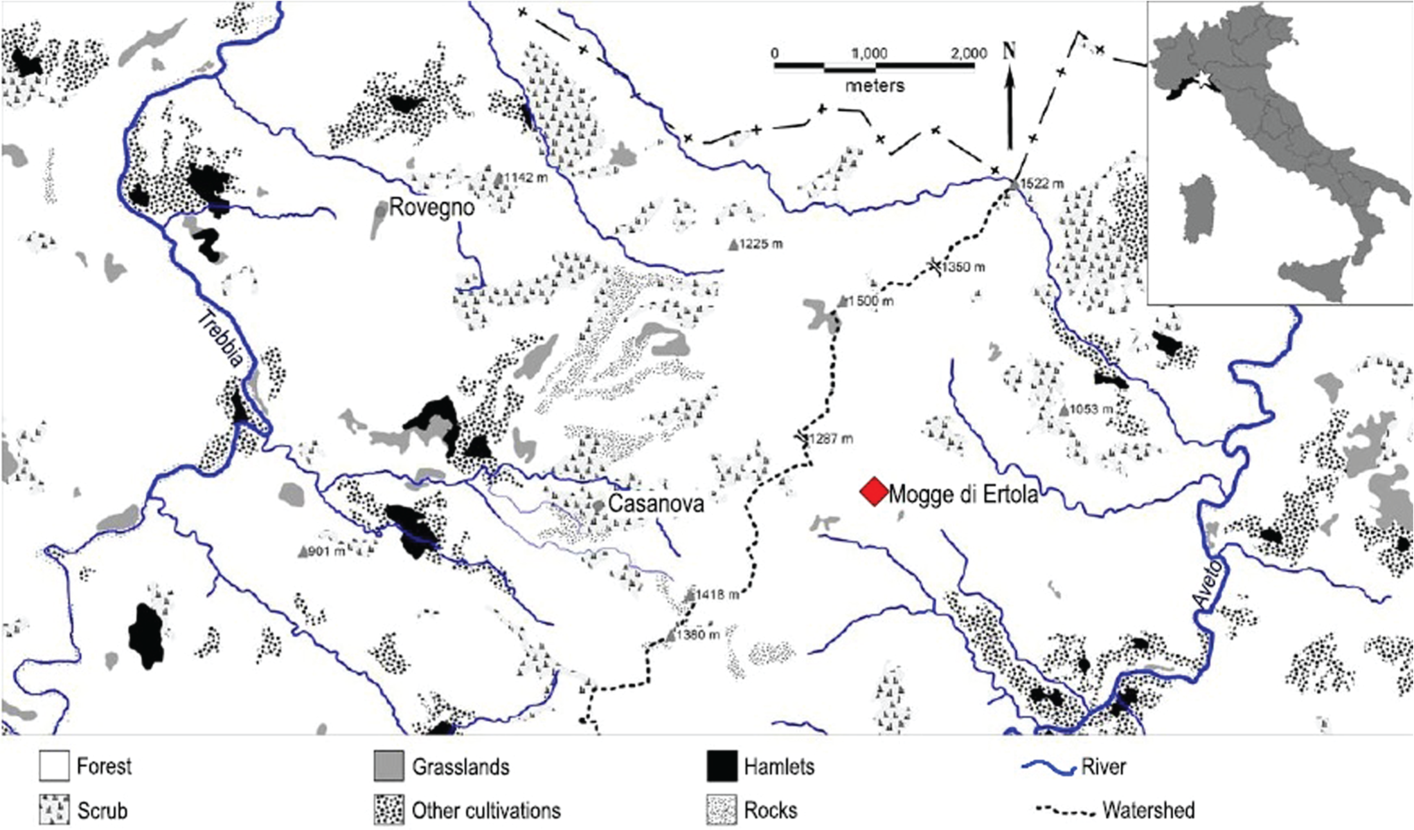
Map of the watershed between the Trebbia and Aveto valleys and of Mogge di Ertola with the location of the coring.
Climatic data from the nearby weather stations of Giacopiane (1016 m a.s.l.), Rezzoaglio (690 m a.s.l.), Cabanne (812 m a.s.l.) and S. Stefano d’Aveto (1014 m a.s.l.) show that the climate is humid, with a mean annual precipitation of about 2000 mm, and two rainfall peaks in November and March–April. The mean annual temperature is about 9–10°C with 3 months of mean minimum temperatures below 0°C.
The plateau vegetation consists of mesophilous grassland with more or less hygrophilous plants, according to local soil moisture. Communities with Juncus spp., Carex spp., Blysmus compressus (L.) Panz. ex Link, Eriophorum latifolium Hoppe, Isolepis setacea (L.) R.Br., Mentha aquatica L., Galium palustre L., Parnassia palustris L., Caltha palustris L., Epipactis palustris Crantz, Orchis incarnata L. and so on are localised where water surfaces. Grasses and plants typical of less humid grassland prevail on better drained soils. The site is surrounded by Fagus sylvatica L. (beech) woodland still subjected to rotation coppicing. Here and there, the aged beech wood coppice reaches the status of a high forest. At lower elevations, Quercus cerris L. (Turkey oak) is more frequent, especially on the dry soils of the steep, rocky slopes facing south. Prunus avium L. (wild cherry), Sorbus aria (L.) Crantz (whitebeam), Salix caprea L. (goat willow) and Sambucus racemosa L. (red elderberry) are also common in the woods. In this mountain area, traditional management practices are still carried out by local farmers and muleteers, with cows, horses and mules that graze the small grassland during the summer.
Archaeology and archaeobotany
The stratigraphic excavation of the plateau covers the late Holocene and shows evidence of fire, few brick fragments and a dry stone wall of uncertain date (proto-historical or post-Mediaeval) at the lower limit of the basin, possibly a feature of water regulations (De Pascale, 2009; De Pascale et al., 2006; Menozzi et al., 2007). Despite the lack of clear evidence of human activities at the site before the Roman period, a long history of their presence since the Palaeolithic is archaeologically documented for the catchment of the site (Campana and Maggi, 2003; De Pascale, 2009).
Several radiocarbon age determinations were obtained for the chronology of the core and of the stratigraphic units, which were identified by parallel archaeological excavations (Table 1). From an archaeobotanical point of view, the site is particularly interesting because of the presence of several waterlogged trunks buried in the peat, mainly of Abies alba Mill. (silver fir). Some of the trunks show traces of various phytophagous insects (M. Pavarino, 2006, personal communication) and of other phytopathogens such as Armillaria mellea (Vahl) Kummer (honey fungus; M. Zotti, personal communication, 2006) or Viscum album L. (mistletoe). The relationship between the ‘fir decline’, recorded throughout the Northern Apennine mountains in the late Holocene, and the evidence of phytopathogens found in this site for the first time has been partially investigated (Menozzi et al., 2010; Montanari and Guido, 2011). In fact, only a wide stratigraphic excavation such as this one can provide large macroremains that may clearly inform about such causes; indeed, pollen from mistletoe, spores of tree pests or evidence of xylophagous insects were not found here or elsewhere. In addition, some trunks show evidence of burning on the surface. Fir trunks buried in peaty sediments are rather common in Eastern Liguria (Banti, 1956; Dagnino and Montanari, 2012), and previous vegetation history studies have also shown that during the Holocene, silver fir formations have suffered severe distributional contractions and eventually were substituted by beech woodlands in the mountain belt of Liguria at different ages in different areas (Bertoldi, 1984; Braggio et al., 1991; Braggio Morucchio et al., 1979; Branch, 2004; Cruise, 1990a, 1990b; Guido et al., 2004).
Radiocarbon ages of the Mogge di Ertola core. Calibrated dates are reported as the range with highest probability. All the dates are AMS (De Pascale, 2009; Menozzi et al., 2007).
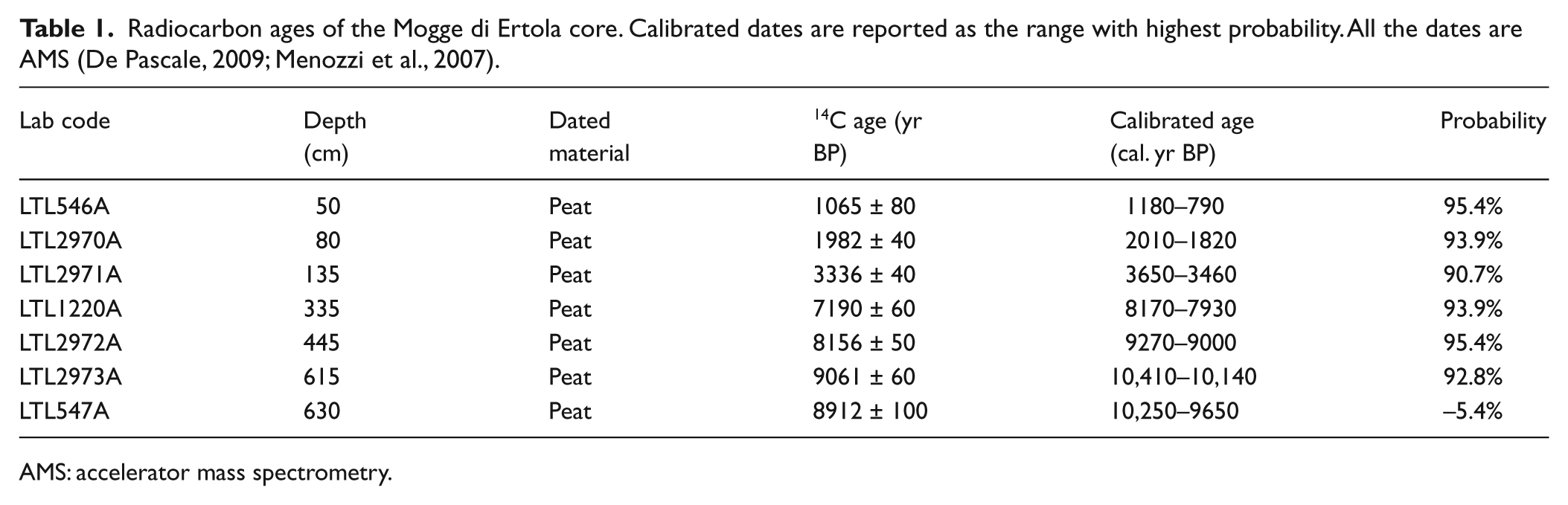
AMS: accelerator mass spectrometry.
Materials and methods
Sedimentology and chronology
The sediments of the core consist mainly of wood peat (633–45 cm); the chronology shows that the peat-bog was active for nearly 8000 years, the most recent peat being dated to the Middle Ages. At the bottom of the core, the sediment is formed by clayey silt with gravel (700–633 cm). At the top, the sediment is silty, and at the surface, it is subjected to paedogenetic processes.
The chronology is based on 19 accelerator mass spectrometry (AMS) radiocarbon datings (Tables 1 and 2), mainly performed at the Centro di Datazione e Diagnostica (CEDAD) of the Università del Salento (Lecce, Italy). The ages are calibrated with the software OxCal Ver. 3.10 and based on INTCAL04 (Reimer et al., 2004). Seven AMS radiocarbon dates of peat samples provide the chronology of the pollen sequence (Table 1); other 12 dates were obtained from plant remains recovered by stratigraphic excavation (Table 2). The samples at 615 and 630 cm of depth indicate that the peat deposition starts at about 10,250 cal. BP, which is one of the oldest records of the beginning of peat accumulation in the Ligurian Apennines, resulting in being synchronous with Lago Riane and more recent than at Rovegno (Branch, 2004). The calibrated chronological scale in the pollen diagram (‘Sample age cal BP’ in Figure 3) was based on the linear interpolation method (TILIA software), which interpolates calculated mean age values with highest probability ranges (Table 1).
Radiocarbon ages of charcoal fragments and wood recovered in the archaeological excavation at the site Mogge di Ertola. Calibrated dates are reported as the range with highest probability. All the dates are AMS, excluding Beta 158361 (De Pascale, 2009; Guido et al., 2003; Menozzi et al., 2007).
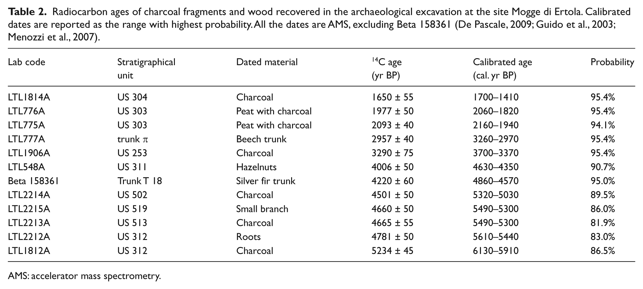
AMS: accelerator mass spectrometry.
Zonation of the pollen data was established with CONISS (Grimm, 1987), and by visual interpretation of the pollen diagram.
Core sampling
Two perpendicular exploratory transects of manual corings were performed, for a total of 15 assays. In this way, it was possible to locate the point where the deposit was deepest, which was chosen for the palynological coring, a few meters away from the archaeo-environmental excavations (Menozzi et al., 2009; Figure 2). A core was drilled in the plateau sediments, providing a 7-m-deep, mainly peaty, sedimentary series.
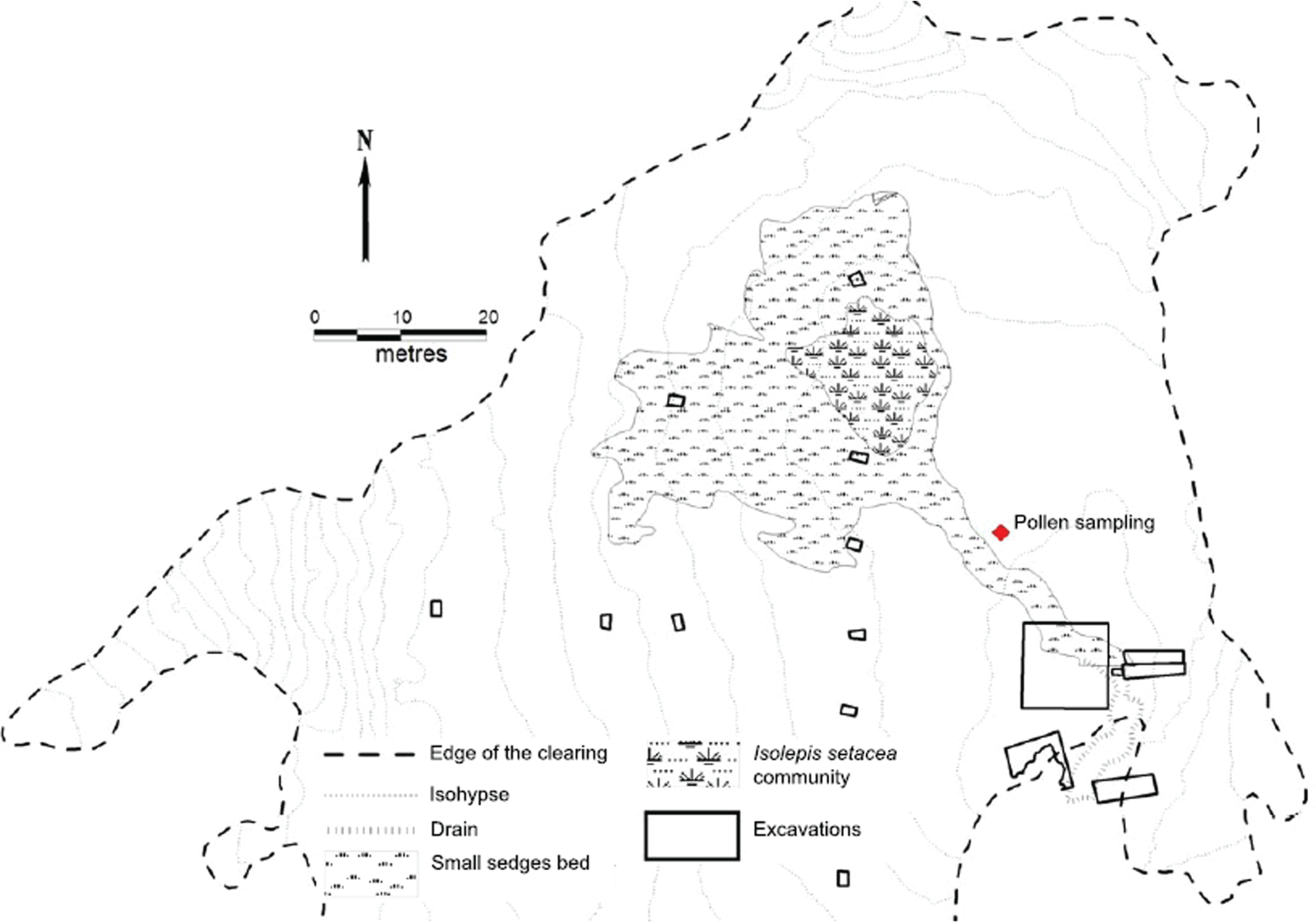
Map of the site of Mogge di Ertola showing type and location of environmental archaeology activities (after De Pascale, 2009, modified).
The core was subsampled each 2 or 10 cm for pollen and microcharcoal analyses. A standard palynological analysis (Fægri and Iversen, 1989) was carried out on 81 subsamples. The identification of the pollen grains followed Fægri and Iversen (1989), Moore et al. (1991), Punt (1976), Punt and Clarke (1980, 1981, 1984), Punt et al. (1988), Punt and Blackmore (1991), Punt et al. (1995) and Reille (1992–1998) and reference collections. Charcoal particles longer than 10 µm were counted in the same slides analysed for pollen (cf. Sadori and Giardini, 2007; Tinner et al., 1998, 1999). For the top meter of the sediments, a NPP analysis was also performed (Menozzi et al., 2010); the identification of the NPP followed principally Van Geel (2001) and Van Geel and Aptroot (2006).
Terrestrial plant pollen and NPP percentages are calculated on the total land pollen (TLP) sum; aquatic plant pollen percentages are calculated on TLP + hygro-hydrophilous and Pteridophyta spores on TLP + Pteridophyta spores; pollen and microcharcoal concentrations (absolute pollen frequency (APF)) were calculated as pollen grains (or microcharcoal fragments) per gram of known sediment volume.
Percentage and concentration diagrams were drawn with TILIA Version 2.0.b.4 and TGView Version 2.0.2 software (Grimm, 1993, 2004). In the pollen diagram (Figure 3), the sum of hydro-hygrophilous herbs includes Cyperaceae, Juncaceae, Sparganium/Typha ang., Alisma, Potamogeton, Sanguisorba officinalis, Myosotis, Gratiola, Parnassia, Utricularia, Butomus, Nuphar, Lemna, Sagittaria, cf. Callitriche and Myriophyllum. Anthropogenic indicators include cultivated plants (Olea, Castanea, Juglans and Cerealia) and spontaneous synanthropic plants (Artemisia, Chenopodiaceae, Centaurea cyanus, Rumex, Plantago lanceolata, Plantago media/major, Urticaceae, Apiaceae, Ranunculus acris, Humulus/Cannabis, Melampyrum t., Fabaceae, Campanulaceae, Brassicaceae, Solanum dulcamara, Linum, Papaver, Knautia, Asphodelus and Polygonum aviculare).
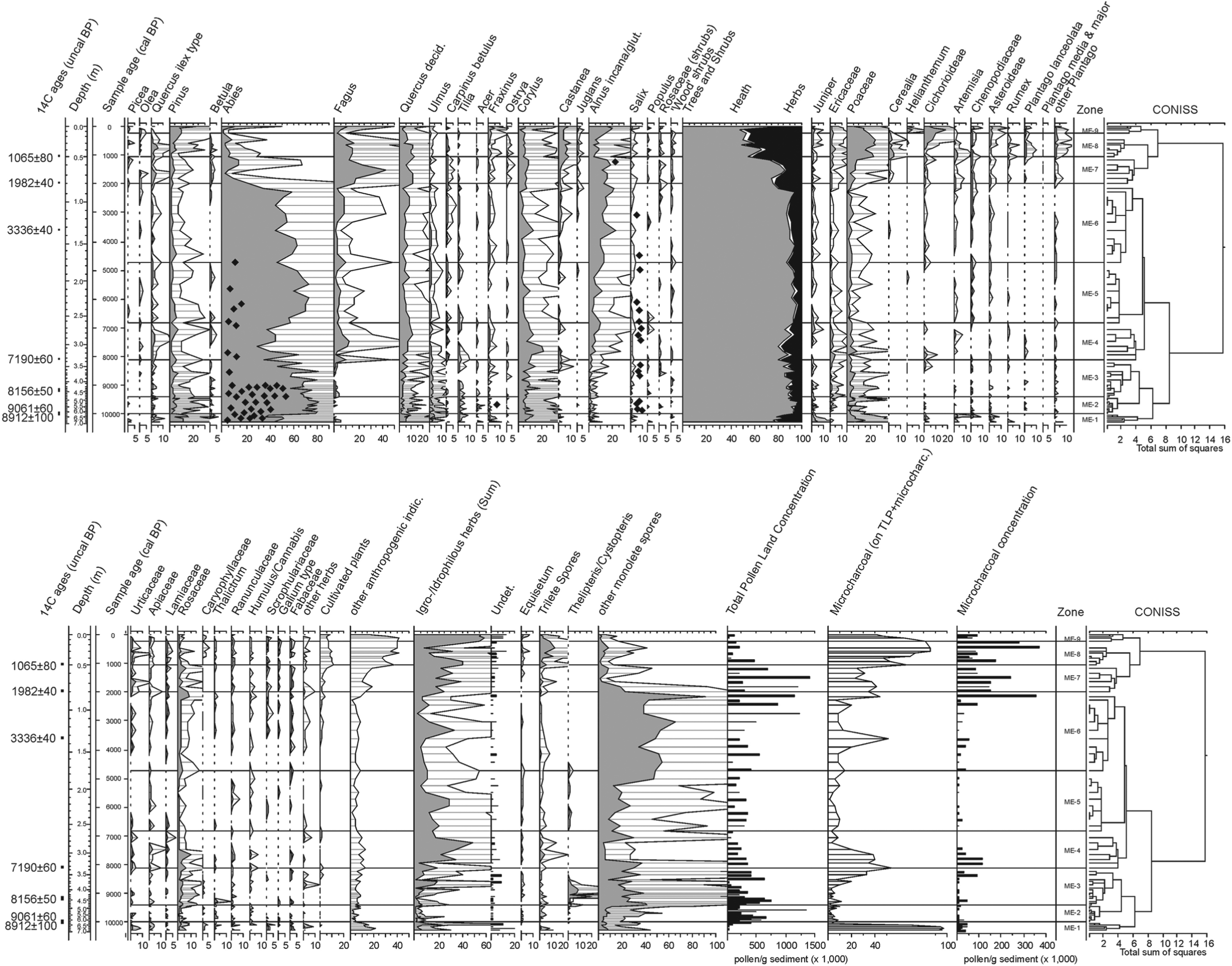
Percentage pollen diagram from the Mogge di Ertola core. The small black diamonds in the graphs of Abies, Fraxinus, Alnus and Salix indicate occurrence of identified wood fragments in the core.
Results
Palynology
The results of the pollen analysis are presented in Figure 3. Overall, tree pollen dominates most of the sequence, apart from a period towards the top of the sequence dated to the Middle Ages. Abies shows the highest percentages altogether, followed by various deciduous broadleaved trees, including Fagus, Corylus, Alnus and deciduous Quercus, and Pinus reaches the highest values in the oldest and most recent levels of the sequence.
The description of the Local Pollen Assemblages Zones (LPAZ ME-1–ME-9) is hereafter reported from the oldest to the youngest.
ME-1 (695–635 cm) Lateglacial/early Holocene transition, previous to 10,200 cal. BP
This part of the deposit, formed by clayey silt, is characterised by a low concentration of pollen grains with abundant microcharcoals. Abies pollen percentages values exceed 40%; Abies macroremains (wood) were also found, testifying to its local occurrence. Pinus reaches the highest values of the sequence (>10%), apart from the plantation evidence of the most recent zone (ME-9); Juniperus, Poaceae, Chenopodiaceae and Artemisia, but also deciduous Quercus and Corylus reach significant percentages. Despite very low pollen concentrations and a mineral sedimentation, a phase of woodland colonisation can be deduced from the pollen data for this time period.
ME-2 (635–475 cm) 10,200–9400 cal. BP
A marked change occurs in the pollen data at the beginning of the Zone ME-2, when peat deposition begins. This phase, lasting approximately 600 years, is characterised by an increase of Abies alongside decreases in Corylus, Alnus and Poaceae. Microcharcoal particles are sporadic, while Abies macroremains (wood) are abundant (black diamonds in the Abies curve; Figure 3).
ME-3 (475–335 cm) 9400–8100 cal. BP
Zone ME-3 is characterised by fluctuating Abies percentage values, ultimately falling back to 40%. Fagus starts its continuous curve, hygro-hydrophilous herbs spread again and Thelypteris/Cystopteris attains 10%. Other broadleaved trees, such as Corylus, Quercus and Alnus increase, alongside increases in microcharcoal particles.
ME-4 (335–275 cm) 8100–7050 cal. BP
Zone ME-4 is well defined by a marked decrease in Abies pollen (from 60–80% down to 30%, the lowest value before the definitive decrease, about 6000 years later) and monolete fern spores, and an increase in Cyperaceae and Corylus, and by the expansion of Fagus. At the same time, microcharcoals reach high relative and absolute values.
ME-5 (275–175 cm) 7050–4700 cal. BP
Zone ME-5 is characterised by an increase in Abies (
ME-6 (175–85 cm) 4700–2120 cal. BP
Zone ME-6 is still characterised by the dominance of Abies alongside increased percentage values of Alnus, while Cyperaceae undergo a slight decrease. Monolete spores show the highest percentage values for the entire sequence. In the upper samples of this zone, high values of Melanconis alni Tul. and other fungal microremains are recorded (Menozzi et al., 2010).
ME-7 (85–55 cm) 2120–1180 cal. BP
Zone ME-7 is characterised by an overall slight decrease of forest trees, with a marked and abrupt decrease in Abies percentage values (from 60% to less than 10%) accompanied by an abrupt increase in Fagus, which reaches 40%. Alnus percentage values remain high. Microcharcoals show high relative and absolute values. Anthropogenic indicators increase, reaching 30%.
ME-8 (55–25 cm) 1180–450 cal. BP
Zone ME-8, which is dated to around the end of the early Middle Ages, is characterised by a decrease in Alnus percentage values, while Cerealia-type pollen grains increase. In general, Poaceae also show high percentage values. Trilete spores, mainly including Pteridium, increase as well as microcharcoal fragments. Signals of human activities are also testified by higher percentages of Castanea pollen and other anthropogenic indicators (e.g. Plantago lanceolata, Artemisia, Rumex).
ME-9 (25–1 cm) 450 cal. BP–today
Zone ME-9 is characterised by a further increase in Alnus percentage values and a decrease in Cerealia type. Also Fagus records low percentage values, while Abies remains below 10%. Cyperaceae record the highest percentage values in the sequence. The most recent samples (1 and 2 cm deep) clearly show increases in Pinus, Abies and Fagus, presumably a response to recent plantations and forest management.
Macroremains
More than 20 Abies trunks and two Fagus trunks were found in the environmental archaeological excavations in an area of nearly 125 m2. One of the lowermost Abies trunks (T 18) is dated to 4860–4570 cal. BP, while one of the beech trunks is about 3000 years old (Table 2). The occurrence of Abies and Fagus tree trunks alongside pollen evidence of a marked and abrupt decline in Abies allowed further work to be carried out investigating the pathological potential of the Abies decline and the dendrochronological potential and evidence of forest management; on this subject, something was already published (Montanari and Guido, 2011; Parola et al., 2012).
Several wood fragments, 9 Abies, 9 Salix and 2 Alnus, and 1 charcoal fragment of Salix were recovered in sediment cores drilled 10 m along two perpendicular transects that cross approximately in the middle of the basin. Abies and Salix wood fragments were uniformly dispersed between 167 and 500 cm of depth in 9 of the 15 cores, while Alnus wood was closer to the surface, between 166 and 235 cm (De Pascale, 2009). Other small wood remains were included in the samples of the palynological core: they consist of Alnus, Salix, Fraxinus and Abies (see Figure 3).
Finally, during the stratigraphic excavations, some cones of Abies and fruits of Corylus, Fagus, Acer pseudoplatanus and Rubus sp. were recovered in the peat between 60 cm and 2 m of depth (US-310 and US-311; Table 2).
Together with the waterlogged trunks, several macrocharcoal fragments were collected at sight in the main archaeological excavations (De Pascale, 2009) carried out next to the coring site and in other small areas scattered in the plateau along two orthogonal lines (see Figure 1). A synthesis of provisional macrocharcoal analysis, concerning charred wood fragments collected at sight in the course of the stratigraphic excavations, is presented in Figure 4. Archaeological excavation records did not go back more than c. 6000 cal. BP. Wood fragments of a variety of tree taxa were recovered, among which Abies is by far the most abundant and constant. Other recorded trees are Pinus, Salix, Alnus, Corylus and Fagus. Regarding the latter, it is interesting to note that, despite its definitive spread from c. 2000 cal. BP in the pollen record and the presence of trunks buried in the peat, beech macrocharcoals are sporadic. Moreover, the highest number of Abies macrocharcoals are dated to around 2200–1900 cal. BP. This fire event is correlated to a peak of microcharcoal concentration in the core and the main decline in Abies pollen percentages.
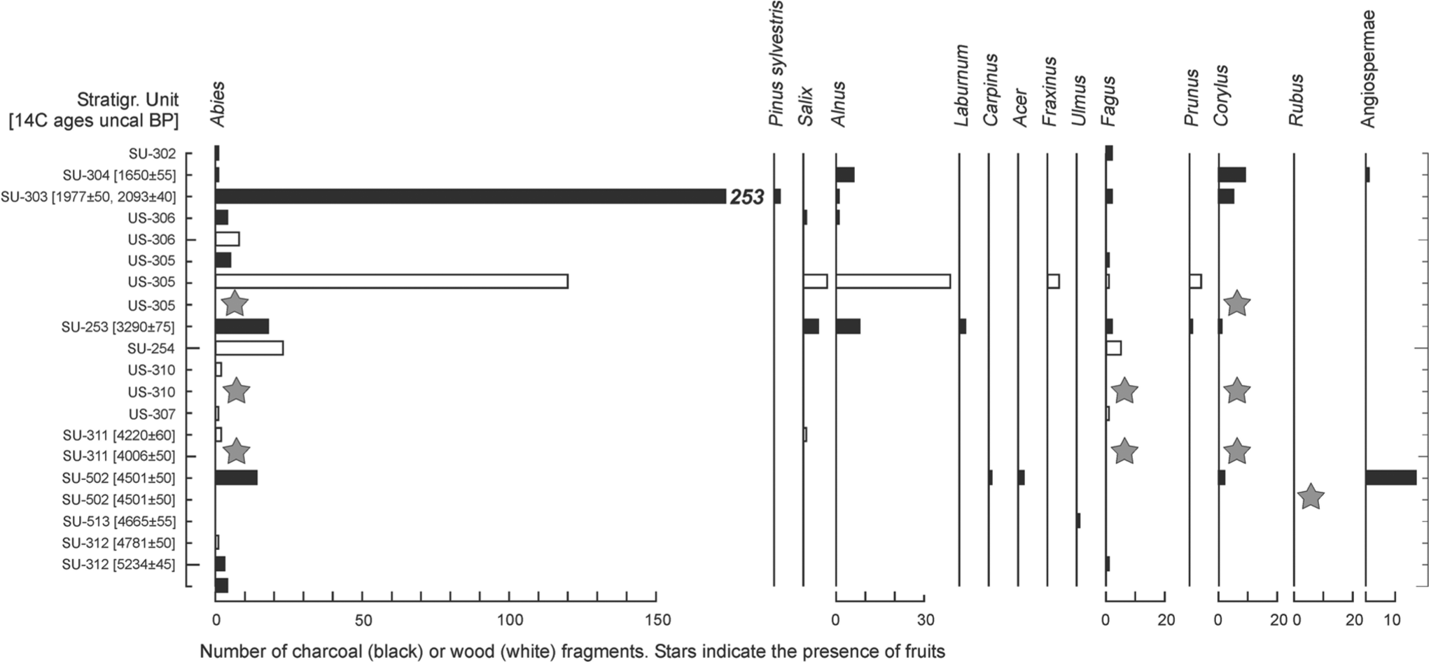
Macrocharcoal and other macroremains recovered during the archaeological excavation. The radiocarbon dates in brackets are in uncalibrated years BP.
Discussion
As mentioned in the introduction, research conducted at the site of Mogge of Ertola has been involving different skills, and a special volume will be needed to fully describe and compare the results produced. Here, therefore, we will discuss only the contribution of palynology and referencing the results of other studies and to some published preliminary notes.
The pollen diagram (Figure 3) shows a Holocene vegetation history which generally agrees with what is already known for the Ligurian Apennines (Bellini et al., 2009a; Branch, 2004, 2013; Cruise et al., 2009; Cruise and Maggi, 2000; Menozzi et al., 2007, 2009, 2010). Nevertheless, the chronology of the events at Mogge di Ertola cannot be easily matched with the regional pollen assemblage zonation proposed by Branch (2004), which is based upon palynological data coming from the same and the next valley. This seems to confirm a certain lack of uniformity in the chronology of the local environmental history, as Branch (2004) has noted. According to the radiocarbon chronology, the pollen record dating to the Lateglacial/early Holocene appears to commence with woodland taxa comprising fir (Abies) and pine (Pinus). However, the presence of juniper (Juniperus), grasses (Poaceae) and mugwort (Artemisia) also indicates a cold–dry grassland. Moreover, very low pollen concentrations and the chronology would suggest a rather open landscape with scattered trees, even if fir wood fragments testify the local occurrence of this relatively mesophilous species (Figure 3). More thermophilous woodland with deciduous oak (Quercus), hazel (Corylus), ash (Fraxinus) and so on was probably restricted to lower altitudes or formed a patchwork with open grassland. Other palynological studies in the Ligurian Apennines show similar results for this period (Bertolani Marchetti et al., 1994; Branch, 2004, 2013; Cruise, 1990a, 1990b; Cruise et al., 2009; Cruise and Maggi, 2000), as do various studies throughout the Northern Apennines (Bertoldi, 1984; Lowe, 1992; Lowe and Watson, 1993; Watson, 1996). Similar environmental reconstructions for the early Holocene were also recorded at lower altitudes, in the coastal belt of Eastern Liguria and Northern Tuscany (Bellini et al., 2009b; Mariotti Lippi et al., 2007). Therefore, the palaeovegetational reconstruction shows that the Mesolithic landscapes in the Ligurian Apennines were formed mainly by conifer woodlands. Microcharcoal particles are abundant in these sediments, and the comparison with a previous study at Casanova (in the next Val Trebbia, c. 2 km westwards; Cruise, 1990a; Figure 1) suggests that fire events, involving the watershed between the Aveto and the Trebbia valleys, took place just near the Pleistocene–Holocene boundary; this could also be in connection with the increasing availability of fuel biomass, as suggested by Turner et al. (2010) for Turkey.
A landscape change at Mogge di Ertola begins around 8100 cal. BP with an evident – though not easily interpretable – retreat of fir, which leaves space for the first true expansion of beech (ME-4). The microcharcoal values recorded from the same levels suggest that this important event could be connected once again to fires in the mountain woods. The rise of opportunist species such as hazel and alder (Alnus) also agrees with the hypothesis of an opening-up of the woodlands around the site at this time.
The importance of fire in the shaping of the Mediterranean ecosystems in North West Italy during the Holocene has been recently assessed by pollen and charcoal analyses carried out in Tuscany (Colombaroli et al., 2008, 2009; Mori Secci, 1996; Vannière et al., 2008; Vescovi et al., 2010) and in Southern Switzerland (Tinner et al., 1999). Nevertheless, the Holocene dynamics of fir and beech in the mountain forests still represent an open debate within the scenario of the vegetation history of the Mediterranean region (De Beaulieu et al., 2005; Liepelt et al., 2009; Magri et al., 2006). At different sites in the Apennines, fir and beech coexist together, and their modern population dynamics involve a competition depending on climate and ecological features but also on the history of the management practices of specific sites. Most likely, the chronology of the spreading of beech varies also in connection with the proximity of possible fir and beech glacial refugia (cf. Magri et al., 2006; Terhürne-Berson et al., 2004). For the Ligurian Apennines in particular, pollen data suggest asynchrony in the shift from fir-dominated woods to beech-dominated woods, which for some areas began in the mid-Holocene, while for other areas in the late Holocene (Bellini et al., 2009a; Braggio et al., 1991; Braggio Morucchio et al., 1979; Branch, 2004; Guido et al., 2004; Lowe et al., 1994a, 1994b; Menozzi et al., 2007). However, all these studies agree in underlining the strong correlation between the pollen evidence for the decline of fir and the rise of beech and the increase of management practices, such as slash and burn, in the mountain forests from the Neolithic till the late Iron Age. These practices – possibly testified by charcoal dust in this site, and also by macrocharcoal – generated openings in the tree cover, favouring the establishment of deciduous broadleaved trees, particularly beech, to the expense of conifers (e.g. Figure 3; around 8000 cal. BP). Moreover, in some cases, the woodland would have never recovered locally due to the onset of an ‘anthropogenic wetland’, that is, the onset of a marshland due to Copper Age deforestation with subsequent soil erosion and infilling of clay, which caused impermeability (cf. Baffico et al., 1987).
It is also important to consider that in palaeoclimatology studies the so-called 8200-yr event marks a well-established and widely diffused cooling/aridification phase in the North Atlantic region (Alley et al., 1997), which corresponded to wetter climatic conditions in the North Mediterranean region and drier conditions in the South Mediterranean (Jalut et al., 2009; Magny et al., 2006, 2007; Pérez-Obiol and Sadori, 2007). For Central Europe, Tinner and Lotter (2006) and Liepelt et al. (2009) have concluded that climate changes, namely, cold and wet events like the 8200 yr cal. BP one, have been the main factor for beech and fir oscillations; the same would also be applicable for North West Italy according to Finsinger and Tinner (2006) and Wick and Möhl (2006).
The starting of the fir/beech shift in the mountain forests of the Ligurian Apennines could therefore be interpreted also as a vegetation response to the 8200 global-scale climate change, but the cause/effect link is not completely clear because of the similar ecology of the two species involved and the mismatching chronology of this shift in different areas. Furthermore, the importance of this global event at a regional and local scale is put in doubt by palaeoecological data coming from the Apuan Alps in North Tuscany, which, albeit revealing higher precipitations between 8900 and 7300 cal. yr BP, do not delineate a major climatic change in this region (Zanchetta et al., 2007).
Overall, it is also possible that human activities – such as managed or wild fires – and climate forcing have acted together in triggering this important vegetation shift in the North West Apennines. The pollen data presented here may record the onset of more oceanic climatic conditions in the mid–late Holocene, favouring beech, alder, hygrophilous herbs, but even deciduous oak and hazel, which are commonly regarded as rather drought-resistant taxa. Thus, the first marked decline of fir could be interpreted as a local response of fir to less favourable climatic conditions.
At Mogge di Ertola, however, this temporary retreat of fir lasted less than a millennium, after which fir re-established itself around 7000 cal. BP and remained the dominant tree of the surrounding mountain forests for a long period of time (lasting approximately 5000 years). In fact, during the rest of the Neolithic and into the Bronze Age, the local situation did not change noticeably, even though an increase in broadleaved trees can be seen. The ‘conservative’ trait of these woodlands, and of most of the Ligurian Apennines, could be partly connected to the intensity and type of human management practices they were subjected to, at least according to the few archaeological traces from these periods which were brought to light till now at the site of Mogge di Ertola and in the surroundings. In fact, in situ human activity in the mid-Holocene is suggested by the evidence of burning (burned branches, scattered charcoals, ashes, dated 4665 ± 55 BP), which was found at the southern edge of the basin (De Pascale, 2009).
Nevertheless, unambiguous signals of local management practices in the Mogge di Ertola pollen record only appear starting from c. 2000 cal. BP (PAZ ME-7), when fir commences its sudden and final retreat and beech becomes dominant in the woodland; macrocharcoal fragments coming from coeval levels of the archaeological excavation show the local burning of fir wood also in the Roman period (Table 2). At this time, the coincidence between the decrease in the fir pollen curve, the sudden increase of microcharcoal values and the high number of fir macrocharcoals (Figure 4) suggests that fire played a key role in clearing the fir wood at this site, allowing beech to spread in the subsequent openings. Actually, open ground is an advantageous habitat for fir seeds to germinate, provided young plants are not shaded by fast growing beech suckers or grazed by wild or domesticated herbivores.
At the wetland of Prato Mollo, a few kilometres inward and 400 m higher, a similar event was explained with human exploitation of the area in the Copper Age, from 5029–4592 cal. BP to 4839–4422 cal. BP (Baffico et al., 1987; Maggi, 2004). So clearing by fire can be suggested also for this more recent episode at Mogge di Ertola, and possibly even for more ancient ones. Indeed, two other minor peaks in microcharcoal concentration correlate with slight decreases in fir pollen and may be explained with clearing of fir woodlands surrounding the site (c. 4700 cal. BP and c. 3700 cal. BP). However, Grove and Rackham (2001) question the classic explanation of agriculture in forest areas through the practice of slash and burn, arguing that ‘the work of clearing and removal of the stumps would have been too burdensome’ (p. 229). Also Lowe et al. (1994a) in a wide – even if rather outdated – review on human disturbance of vegetation of the Northern Apennines concluded that ‘no clear evidence of the local presence of cultivated plants has yet been recovered from the mountains of Liguria and Emilia Romagna prior to the historical period’; all the same, they too describe evidence of human management starting around 5000 BP, probably due to thinning, creation of wooded pastures and subsequent erosion.
In the early Middle Ages (1065 ± 80 BP, 770–1160 cal.
Summing up, in the last 9000 years, the Mogge di Ertola landscape was characterised by mountain forests, in which silver fir played a major role. On the basis of pollen assemblages, clear evidence of clearing and cultivation starts only from the Roman period, although abundant charcoals and microcharcoals could testify to Mesolithic and even Neolithic forest management by means of fire. At intermediate altitudes, it is also likely that the impact of human activity and its traces has been less intense than in the lowlands and near the ridges (cf. Moe et al., 2007), and a recent study devoted to assess the fire activity at a Mediterranean scale concluded that wild, climatically induced fires dominated most of the Holocene (Vannière et al., 2011), minimising the importance of human activity in this regard. However, micro-historical studies in the Ligurian mountains have shown that ancient agricultural techniques like local slash and burn such as the ‘ronco’ and ‘alnoculture’, date back at least from early Mediaeval times and have continued up to modern times (Cevasco, 2007; Guido et al., 2003) but, since they were undertaken for limited periods in small patches of woodland, they are not so easy to detect, neither archaeologically on the field nor archaeobotanically in the sediments. When wild species such as alder were used, it gets even more complicated to separate human from natural triggers of landscape change. The same must be applicable for different kinds of wooded grassland or ‘cultural savannah’, which in a pollen record can be suggested only if further sources of information are available, like documentary evidence. In fact, when targeted studies are undertaken, at least for historical times, evidence of a few practices can be suggested when multiple types of sources are available to compare (cf. Cevasco, 2007; Molinari, 2009).
Conclusion
The wetland of Mogge di Ertola has proven to represent one of the most promising archives of the landscape history of the Ligurian Apennines. The stratigraphic excavation delivered a large volume of tree logs of different species, but especially of silver fir which, apart from allowing dendrochronological investigations, are becoming important to understand the reason for the disappearance of this species in historical times; in particular, the discovery of plant pathogens such as mistletoe, fungi and insects represents a decisive step in this direction. Moreover, the palynological study of the sediments – parallel but independent from the archaeological stratigraphy – was carried out to compare the information provided by microremains such as pollen, NPP and microcharcoals with those arising from macroremains, in this case especially large trunks, which can be recovered only with extensive excavation.
Despite some archaeological evidence of human presence in the region and in the same watershed since the Palaeolithic period, the palynological record does not show unambiguous proof of prehistoric human activities at the Mogge di Ertola and in its surroundings. Apart from the undated dry stone wall, archaeological evidence from the site is lacking, supporting the idea of low human impact until the Roman period. But evidence of environmental changes and their possible causes can be mainly found in the palynological record: around 8200 cal. BP, the sequence shows the expansion of beech that occurs simultaneously with a retreat of fir and high microcharcoal concentrations. In order to interpret this event, we can take into consideration the Neolithisation process, which would account for an increase of the fire regime and the decrease of fir that must have favoured the spreading of beech and hazel. Moreover, if the occurrence of micro- and macrocharcoal can be assumed as an evidence of landscape management by fire, then it would be recorded at least since the Mesolithic.
Several European sequences recorded the 8200 event as a cool event, which was cool/wet in the North Mediterranean, often associated to a microcharcoal increase: this could have favoured for several centuries the more mesophilous beech against fir. However, fir was able to recover fully and remained the dominant species in the mountain woodland for the next 5000 years. Only in historical times did land-use practices leave clear evidence in the ‘pollen image’ of the landscape of woodland opening and occurrence of anthropogenic indicators such as cereals, chestnut, walnut and other synanthropic plants. So even if in recent studies the climate-driven vegetation changes have been largely reassumed, for the final ‘fir fall’ recorded throughout the Northern Apennines in the Roman period (c. 2000 BP) at least a co-occurrence of climatic and human factors remains the most likely assumption.
As expected, the combination of micro- and macroremain evidences proved to be useful for tracing some of the factors underlying the vegetational dynamics. Moreover, the analysis of waterlogged fir trunks showed the presence of pathologies that could be one of the causes of the fir collapse, while clear traces of cutting were not found, apart from a supposed trace of silver fir pruning, the study of which is still in progress.
General conclusive considerations on this environmental archaeology approach to a Mediterranean mountain wetland will be possible only when the results from the different disciplinary studies will be compared in a more systematic way. Indeed, when a variety of informational sources are available, a more integrated paleoenvironmental scenario can be achieved, even if the complexity of interpretation increases accordingly.
Footnotes
Acknowledgements
The authors sincerely thank the students, the archaeologists and all the researchers who participated in the environmental archaeology excavations. They are specially grateful to Roberto Maggi (MiBAC) for the archaeological project and for the useful comments on the text and to Sarah Metcalfe, Christa Backmeroff, Dagfinn Moe and Diego Moreno for suggestions and fieldwork. Finally, the authors thank Marta Mariotti Lippi and an anonymous reviewer for their accurate and useful review of the manuscript.
Funding
This study is based on researches financially supported mainly by the project ‘Studio di fattibilità di un progetto per la conoscenza, conservazione e valorizzazione delle zone umide liguri’, sustained by MiBAC (Ministero per i Beni e le Attività Culturali) and developed between 2004 and 2006 by the L.A.S.A. (Dismec-Dipteris) in collaboration with the PhD Course ‘Historical Geography for the enhancement of the historical-environmental Heritage’, University of Genova. Parco Naturale Regionale dell’Aveto and Parco Naturale Regionale dell’Antola financed boarding and lodging for participants in campaigns of environmental archaeology.