
Abstract
Hundsalm ice cave located at 1520 m altitude in a karst region of western Austria contains up to 7-m-thick deposits of snow, firn and congelation ice. Wood fragments exposed in the lower parts of an ice and firn wall were radiocarbon accelerator mass spectrometry (AMS) dated. Although the local stratigraphy is complex, the 19 individual dates – the largest currently available radiocarbon dataset for an Alpine ice cave – allow to place constraints on the accumulation and ablation history of the cave ice. Most of the cave was either ice free or contained only a small firn and ice body during the ‘Roman Warm Period’; dates of three wood fragments mark the onset of firn and ice build-up in the 6th and 7th century
Introduction
Perennial cave ice accumulations are known from many mid-latitude mountain regions (Luetscher, 2013; Perşoiu and Onac, 2012) and owe their formation to special cave geometries which favour seasonally controlled air flow patterns (e.g. Luetscher and Jeannin, 2004; Saar, 1956). As a result, these cavities act as natural ‘freezers’ that accumulate incoming seepage water as congelation ice. Sag-type, static ice caves may also receive a significant amount of winter snow falling into the cave entrances forming bodies of firn and ice via densification and recrystallisation (Ford and Williams, 2007; Luetscher et al., 2005; Yonge, 2004). Although not as thick and not directly comparable to sedimentary glacier ice on the Earth’s surface, several studies suggested that cave ice may represent an interesting archive for past environments and climate (e.g. Feurdean et al., 2011; Hercman et al., 2010; Holmlund et al., 2005; Sancho et al., 2012; Stoffel et al., 2009).
The Eastern Alps of Austria host a number of ice caves, which are considered to be among the largest on Earth (Ohata et al., 1994), including Eisriesenwelt at Werfen (Salzburg) and Dachstein-Rieseneishöhle at Obertraun (Upper Austria). First attempts to determine the age of these impressive underground ice masses used pollen. Kral (1968) and Schmeidl and Kral (1969) examined deep ice layers in the Dachstein-Rieseneishöhle and found a dominance of pollen transported from Alpine pastures utilised by farmers to graze cattle since the 15th century
One aspect that emerged from these studies is the loss of ice at least during the second half of the 20th century (e.g. Behm et al., 2009). Conversely, no evidence of a significant positive mass balance during the past few decades has been reported from any natural and undisturbed ice cave in the Alps. This development underpins the need for a profound understanding of the ice dynamics in these caves. In spite of strong international efforts to detect, monitor and model the distribution and apparent decay of permafrost in near-surface environments in the Alps, this research has not been extended to perennial ice in karst systems, which remains heavily under-researched (cf. Kern and Perşoiu, 2013).
The aim of this case study was to constrain long-term ice thickness changes in a small and well-understood Alpine ice cave. We took advantage of frequent occurrences of wood remains in the ice of this cave, assembled the largest radiocarbon database currently available for any ice cave in the Eastern Alps and discussed possible relationships to the late-Holocene climate evolution mirrored by changes in the size of Alpine glaciers.
Study site
Hundsalm Eishöhle und Tropfsteinhöhle – Hundsalm ice cave for short – is located in a karst area 55 km ENE of Innsbruck in the western part of the Northern Calcareous Alps (12°01′35″N, 47°32′42″E; Figure 1). The cave opens at 1520 m a.s.l. in a spruce and larch forest adjacent to pastures. The mean annual air temperature at the cave site is 4.2°C, and the mean annual precipitation is c. 1400 mm, 40% of which falls as snow between November and March. First explored in 1921, Hundsalm ice cave was opened as a show cave in 1967. The cave formed along a NNW-SSE-trending fault in middle Triassic limestone (Wetterstein Formation) and can be divided into an upper and a lower level. The upper level is connected to the surface via two shafts (referred to as Unterer Einstieg and Oberer Einstieg, respectively) and contains perennial firn and congelation ice. Its deepest part is 34 m below the entrance (i.e. Unterer Einstieg) and the maximum N-S extension is 42 m (Figure 1).
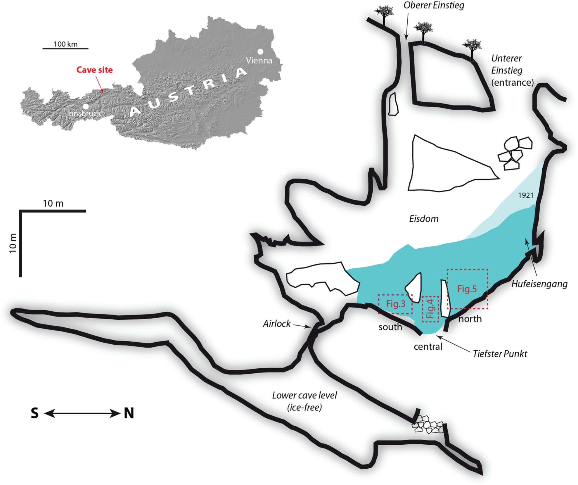
Location and longitudinal section of Hundsalm ice cave. Snow, firn and ice deposits in the upper level of the cave are shown in light blue. Note that due to its west-east inclined geometry, the ice body appears thicker in this longitudinal perspective than in reality. The snow cone at the base of the northern (lower) shaft at the time of the discovery of the cave (1921) and its much smaller size today are shown for comparison. Little is known about the change in elevation of the floor ice during this time interval, but it seems to have gradually decreased in recent decades. The three sectors shown in more detail in Figures 3 to 5 are indicated by red stippled rectangles.
The lower level of the cave extends down to 55 m below the entrance, lacks ice and hosts actively forming speleothems (soda straws and moonmilk; Reitschuler et al., 2012). This level was discovered in 1984 by excavating a gallery that led to a narrow fracture, which was widened and subsequently closed by an airlock to prevent air exchange between the two cave levels.
Firn and ice deposits
Firn and ice are present in more than half of the area of the upper level of the cave reaching their maximum thickness in the Eisdom and thinning in southerly direction. The northern part of the cave is occupied by a body of firn showing steeply inclined strata, which clearly hint towards Unterer Einstieg as the entry point. Old reports document the existence of an 8-m-high and ice-covered snow cone at the base of Unterer Einstieg shaft (Hossé, 1921; Spötl, 2013). This cone, which has been strongly modified during show cave development (installation of a metal staircase and a door), is composed of white, granular firn derived from snow and contains frequent stringers of translucent ice (melt layers). Inclusions of rock fragments are rare, but organic remains, including wood pieces, are not uncommon in the firn.
The Eisdom itself and the southern part of the cave comprise large amounts of congelation ice formed by freezing of seepage water. Grainy firn layers and remnants of broken icicles are also present. Stratification is crude and less steep than in the northern, firn-dominated part of the cave and is delineated mostly by thin layers of dispersed brown loam, probably representing intervals of strong cave ice ablation. Scattered angular rock fragments ranging in size from 1 to 30 cm are common in the lower part of this ice deposits, while organic remains are scarce. Steam drilling recorded an ice thickness of up to 2.8 m in the Eisdom, but this is likely a minimum value given the fact that stones were frequently hit (Spötl and Obleitner, 2008). The lower part of this central ice body is accessible near the deepest point of the show cave trail (Tiefster Punkt, Figure 1) and exposes ice up to 7 m thick.
In addition to congelation ice, firn and snow, the cave also hosts a variety of largely non-perennial ice formations, in particular ice stalagmites, stalactites and columns. They form typically during winter and early spring as very clean, glass-like congelation ice and decay over the following weeks and months. Recrystallisation occurs as soon as the cave air temperature reaches the melting point giving rise to murky, coarse-granular ice with very little internal strength. Some larger ice formations survive the ablation period and re-grow the following year, but in recent years, ice formations have tended to decrease and mostly disappeared by the end of fall. Written reports and old photographs show that the abundance of these ice formations has declined since the 1920s (Spötl, 2013), but detailed accounts are not available.
Since the late 1960s, cavers actively shovelled snow into both shafts in an attempt to manipulate the ice mass balance in the cave. This practice was largely stopped in 2007, and since then, the height and volume of the artificial snow cone that had built up underneath the Oberer Einstieg shaft has steadily decreased to reach a height of only c. 1.5 m in late 2012 (Figure 1), and its surface was composed entirely of old ice with abundant stone fragments.
In this study, we concentrate on the lower (older) parts of the firn and ice deposit which clearly formed prior to the artificial introduction of snow into the cave and which are well exposed along the lower part of the show cave trail.
Cave meteorology
The meteorology of Hundsalm ice cave has been monitored since 1993 using a series of temperature loggers inside the cave and an automatic weather station outside the cave. These data allow to establish a qualitative model of air circulation, which is typical of such sag-type depressions (e.g. Luetscher and Jeannin, 2004). Only a short summary is provided here as a detailed account will be presented elsewhere. The annual temperature cycle in the ice-bearing upper level of the cave shows two regimes, the winter and the rest of the year. A density-driven air flow (convection) is initiated when the outside air temperature drops below c. −2°C. The ‘warm’ cave air exhales from the upper cave entrance initiating a convection cell draining cold air into the main cave chamber via the lower shaft (Figure 2). Accordingly, the lowest air temperatures are recorded in the northern part of the Eisdom (Figure 2), whereby the intervals of cold air invasion closely track the outside air temperature evolution. This winter ventilation regime is initiated between mid-October and early December, lasts until mid-March to early April and is succeeded by a period of virtually no air exchange between the outside atmosphere and the interior of the cave. Solar radiation only reaches the uppermost few metres of the main vertical shaft causing minor warming and air mixing there. Ice melting during the warm season is largely due to heat exchange at the rock-ice interface and from localised water inlets. Between spring and fall, the air temperature in the cave stays within a few tens of a degree of the freezing point (Spötl, 2011; Spötl and Obleitner, 2008; Figure 2) except for the southern, ice-free tip of the cave where the temperature is always close to +1°C and ice only occurs until early summer.
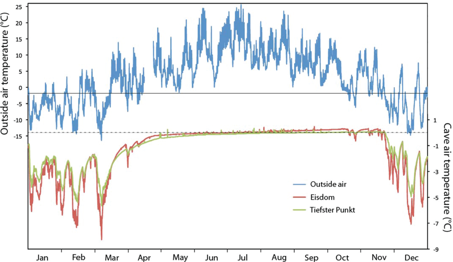
Annual thermal regime in Hundsalm ice cave compared with the air temperature variability recorded by a weather station outside the cave (in 2010). Once the surface air temperature falls below c. −2°C (solid horizontal line), air sinks into the cave via the lower vertical pit (Unterer Einstieg – Figure 1) and ascends through the upper vertical pit in a ‘chimney-like’ fashion. Minimum temperatures in the Eisdom are lower than those in the deepest part of the ice cave (Tiefster Punkt). The spring to fall regime is characterised by stagnant air decoupled from the surface air temperature evolution, slow ice melting and cave interior temperatures close to the zero point.
The temperature in the lower level of Hundsalm ice cave is 4.2 ± 0.1°C (1998–2011). This value corresponds to the mean annual air temperature of the outside atmosphere at the elevation of the cave.
Methods
The lower part of the ice and firn near Tiefster Punkt, which is accessible along the tourist trail, has been carefully examined over several years for inclusions of organic macro-remains. A narrow gap between the rock wall and the deeper parts of the ice, which was enlarged artificially in the early 1970s, has gradually widened over the past decades, thereby exposing rock and organic inclusions in the cave ice wall. Only discrete wood remains were sampled, excluding amorphous black residues of uncertain origin which are also present in the ice. Where larger pieces of wood were found, we only used the outermost and youngest parts for radiocarbon dating. Samples were prepared at the 14CHRONO Centre, Queen’s University Belfast, and analysed using acceleration mass spectrometry (AMS). OIS 7 kauri wood (Hogg et al., 2006) provided by A Hogg, University of Waikato, was used for the background correction. Ages were calculated according to Stuiver and Polach (1977) using the AMS measured 13C/12C, which accounts for both natural and machine isotope fractionation. Ages were calibrated using IntCal13 (Reimer et al., 2013) and the CALIB 7.0 software (Stuiver et al., 2013). Calibrated ages are reported with two standard deviations (2σ).
Results
Wood remains were found and sampled in three sectors along the base of the ice body as shown in Figure 1, and the results are given in Table 1. With the exception of one sample from the southernmost tip of the exposure, all samples yielded historical ages when calibrated using IntCal13. Four samples overlap in their calibration range with wood grown during the nuclear testing phase of the 1950s and 1960s (Table 1), and they also appear too young when compared with samples above and below in the profiles.
Radiocarbon data of wood samples from Hundsalm ice cave.
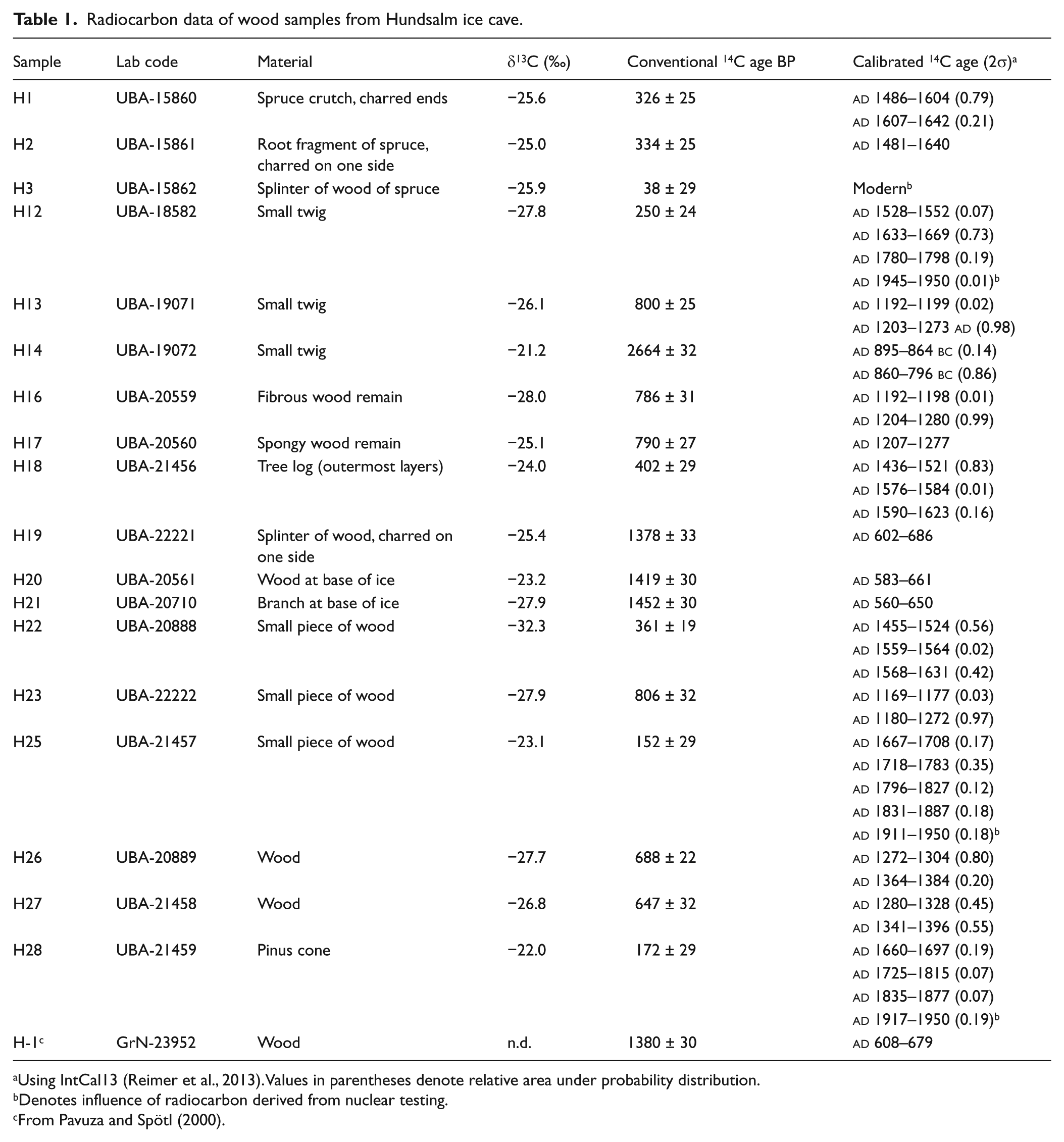
Using IntCal13 (Reimer et al., 2013). Values in parentheses denote relative area under probability distribution.
Denotes influence of radiocarbon derived from nuclear testing.
From Pavuza and Spötl (2000).
The southern sector (Figure 3) revealed only scarce remains, and they were all smaller than a couple of centimetres. The southernmost sample (H14) turned out to be the oldest remains found so far in Hundsalm ice cave (2664 ±32 BP, 895–796
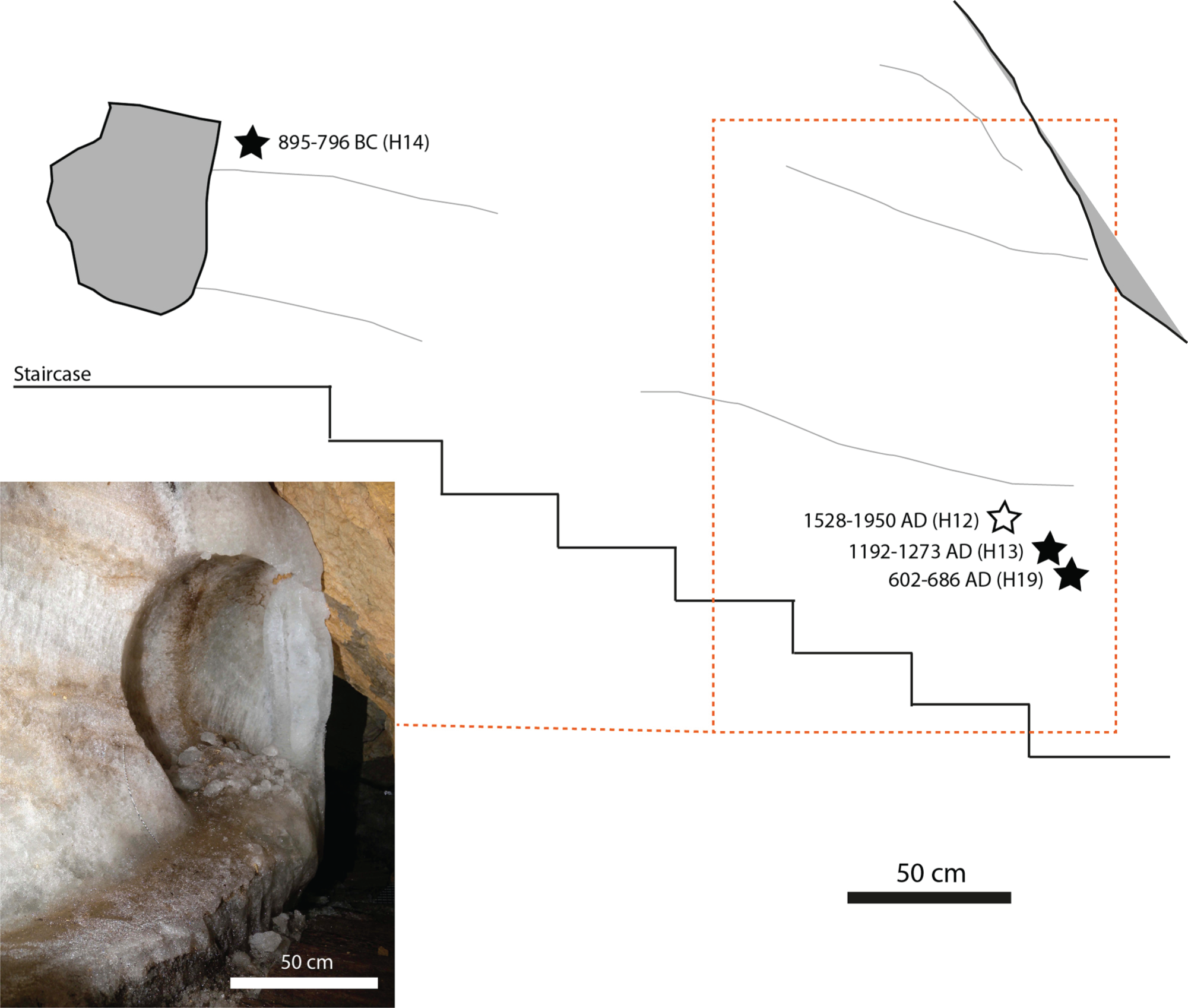
Sketch of the southern sector of the basal ice in Hundsalm ice cave showing sedimentary layering, stone inclusions (in light grey) and sampled wood remains (asterisks). One sample suggests growth during the nuclear testing years of the 1950s and 1960s (open asterisk). Ages are given in calibrated radiocarbon dates (2σ range).
Most wood remains were found in the central sector right at the Tiefster Punkt (Figure 1). We sampled across a c. 2-m-high ice profile, which shows evidence of multiple melting periods (unconformities marked by brown loam; Figure 4). The lowest ice is conspicuously less pure than the higher layers and contained most wood fragments. Ages range from 806 ± 32 BP (
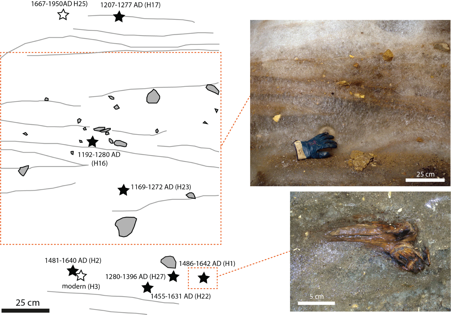
Sketch of the central sector of the basal ice in Hundsalm ice cave showing sedimentary layering, stone inclusions (in light grey) and sampled wood remains (asterisks). Two samples suggest growth during the nuclear testing years of the 1950s and 1960s (open asterisks). Ages are given in calibrated radiocarbon dates (2σ range).
The northern sector exposes a thick section of inclined firn strata and intercalated clean ice (melt) layers resting on ice-cemented rubble overlain by firn (Figure 5). Two pieces of wood were found directly at the boundary between the rubble and the ice and yielded consistent ages of 1419 ± 30 BP (
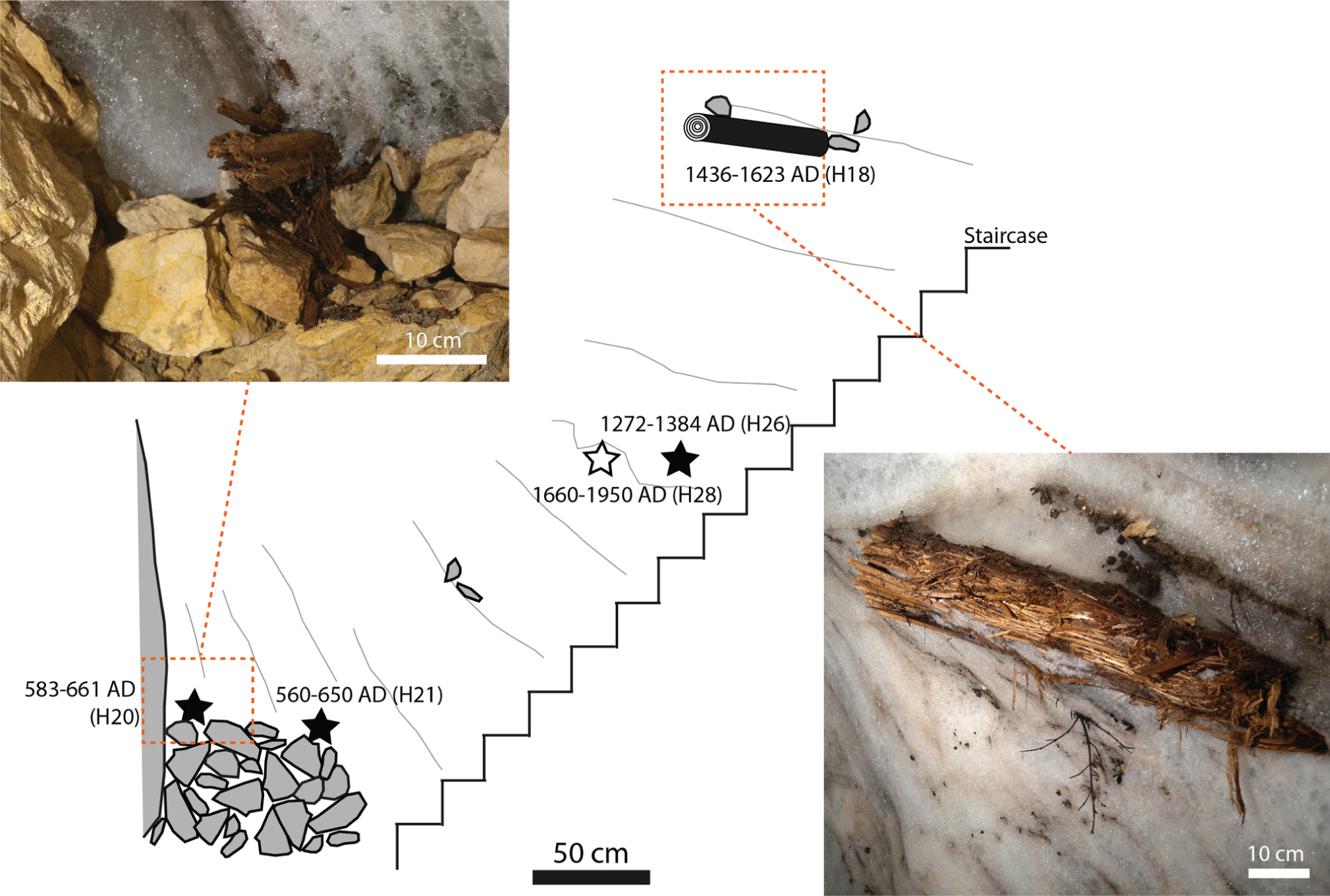
Sketch of the firn profile exposed along the staircase in the northern sector of the Hundsalm ice cave showing sedimentary layering, stone inclusions (in light grey) and sampled wood remains (asterisks). One sample suggests growth during the nuclear testing years of the 1950s and 1960s (open asterisk). Ages are given in calibrated radiocarbon dates (2σ range).
Discussion
Processes of snow and ice accumulation
Hundsalm ice cave illustrates the challenge in applying stratigraphic principles to subsurface ice bodies and their inclusions, but also the potential to identify periods of net snow and ice accumulation as well as – albeit indirectly – periods of little ice in this cave (cf. Stoffel et al., 2009). Key to understanding the long-term dynamics of accumulation in this type of cave is the observation that there are two types of deposits, snow and congelation ice. The former was largely sourced from the lower (northern) shaft, because the cross section of the entrance to the upper shaft is too small to allow for significant amounts of snow to enter the cave. Despite the fact that cavers have actively introduced snow into the cave since the late 1960s, the volume of the snow cone at the base of the lower shaft is now smaller than in 1921 when the cave was discovered. In addition, the elevation of the congelation ice floor in the Eisdom has gradually decreased due to surface ablation, and the gap between the rock walls and the ice body has opened up.
Ablation in Hundsalm ice cave occurs by heat exchange at the rock-ice interface, localised melting at water inlets and by ablation at the ice and firn surface. The key parameter in sag-type ice caves is the extent of winter cooling of the cave, that is, the summer ablation period is pre-conditioned by the preceding winter. Instrumental data (Spötl, unpublished data) show that the colder the winter, the greater the sensible heat exchange and the less ablation occurs during the subsequent summer and autumn. There is no evidence of significant basal ice melting in this cave, but we cannot rule out the possibility that this process was more relevant in the past. Unfortunately, no long-term instrumental measurements of these processes are available. The gradual widening of the gaps between the rock walls and the margins of the firn and ice body in recent decades, however, demonstrates that ablation at the rock–ice interface is an important mechanism in this cave. In addition, recent years have also seen a strong increase in the localised melting at drip sites giving rise to cylindrical melting holes up to 0.8 m wide and 0.4 m deep. Ablation at the ice–air interface also plays a role, but stake data – available since 2007 – record only a slow, albeit uninterrupted, decline in ice elevation in the Eisdom (Spötl, 2011 and unpublished data). The overall mass balance in Hundsalm ice cave has clearly been negative at least since the beginning of the 21st century, consistent with observations of cave ice mass balances across Europe (e.g. Kern and Perşoiu, 2013; Luetscher et al., 2005; Perşoiu and Pazdur, 2011).
Organic inclusions in ice
Key to constrain the depositional age of firn and ice in karst cavities are inclusions of organic remains (cf. Luetscher et al., 2007). Hundsalm ice cave is well suited for such a study given that sag-type caves act as natural traps (e.g. Stoffel et al., 2009), quite unlike ice bodies in dynamically ventilated caves, which are largely devoid of organic macro-remains (e.g. May et al., 2011).
Organic remains per se do not date the age of the surrounding layer of firn or ice given their finite age prior to falling into the cave. The lag involved between the time of wood growth and its introduction into the cave may be up to several decades in the case of wood from old trees (K Nicolussi, 2012, personal communication). The (calibrated) radiocarbon dates therefore provide a maximum age for the snow and ice surrounding a particular fragment. If the samples are from small twigs – as most samples in this study – the lag is likely shorter (and certainly within the uncertainties of the radiocarbon age calibration). In addition, there is a potential lag between the time a piece of wood falls into one of the shafts and the actual time of embedding in the accumulating firn or ice. It is possible that this could cause the ice to appear older by several tens of years judging from the degree of decay of wood artificially introduced into the shafts by cavers. This transport effect was probably more relevant for the central and southern part of the ice exposure examined in this study (where wood was introduced through the upper shaft), than for the northern part. There, the steep snow and firn cone facilitated the rapid transport of organic remains into the deep parts of the cave.
The rate of wood falling into a cave like Hundsalm is not known, but as a first approximation, we assume that natural events which may cause the introduction of wood fragments into the shafts of the cave (storms, lightning, forest fire, heavy snowfall) did not show large changes in their frequency on timescales of several hundreds of years. As a consequence, a firn or ice succession – if deposited at a near-constant rate – should show a general progression of ages from top to base (allowing for some delay effects as outlined above). Ice, however, may be subject to melting, both at the ice–air and the ice–rock interface. Basal melting was not observed in Hundsalm ice cave, but evidence of surface ablation is widespread. Melting of a given package of ice or firn gives rise to a layer of insoluble residue marking an unconformity. Organic remains from this layer should show a spread in ages corresponding to the age interval represented by the former firn/ice package, whereby the oldest and youngest dates provide age constraints on the onset and end of this ablation interval, respectively. Organic remains in successions lacking unconformities and showing a normal progression of ages across a given interval hold the key to date periods of positive mass balances. Conversely, organic inclusions concentrated along discrete unconformities provide constraints on the timing of periods of negative mass balances. Given the complex geometry of caves and the typically inclined surface of ice therein, various gravitational processes, for example, re-distribution, may play a role. A critical zone in Hundsalm ice cave (and many other ice caves) is the gap between the host rock and the ice body, which allowed wood remains to be collected from the deeper ice layers. This gap widens during periods of negative mass balances and acts as a trap for, for example, organic remains sliding down the steep slope of the ice body. During subsequent periods of positive mass balances, the gap will be closed by young firn and/or ice resulting in complex and possibly inverse stratigraphies when exposed during the next cycle of ice cliff withdrawal.
Evaluation of calibrated ages of the wood inclusions
Given the inherent complexities and local effects normal stratigraphic successions in sag-type ice caves such as Hundsalm ice cave are probably the exception rather than the rule. It is important to understand the local cave geometries and to use a large collection of dated organic remains to disentangle the local stratigraphies. Bearing this in mind, we collected and dated 19 samples spread over a short distance (17 m) in order to unravel the history of the ice and firn body in Hundsalm ice cave.
The northern sector is composed of a large firn cone extending all the way to the deepest part of the cave and showing consistently steep inclination of its layers. It is separated from the central and southern ice parts by a few metres of limestone. The onset of snow and ice accumulation in this northern part is constrained by two dates to between
The central sector, right at the Tiefster Punkt, lacks evidence of wood remains dating back to the 6th and 7th centuries
Less age control is available for the southern sector where the ice gets thinner and comprises mostly congelation ice. Sample H19 is identical in age to the oldest wood remains in the northern profile (7th century
Is there a climate signal in Hundsalm ice cave?
The most important input term in the Hundsalm cave ice mass balance is the amount of winter snow entering the cave (Figure 2). Sensible heat transfer (cooling of the cave walls) associated with strong air exchange between the outside and the cave atmosphere during cold winters increase the chance for newly accumulated snow and ice to survive until the next winter. Long and cold winters and/or winters with high amounts of snowfall also favour enhanced infiltration during spring snow melt in the catchment of the cave’s drip waters giving rise to abundant formation of congelation ice upon entry into the undercooled cave. Conversely, a series of dry and mild winters will cause starvation of the snow and ice deposits eventually leading to dominant ablation due to insufficient cooling of the cave.
Based on this conceptual model, we explore whether Hundsalm ice cave shows similarities to the long-term history of Alpine glaciers, the most obvious archive of late-Holocene climate change in this mountain range. Their mass balance, although fundamentally different from that of subsurface ice bodies (which lack energy input by shortwave radiation), is also sensitive to the amount of winter precipitation. For example, the major glacier advances at the end of the LIA between
Radiocarbon-dated wood fragments allow to extend the history of snow and ice in the Hundsalm ice cave back in time and to explore the proposed link to surface glaciers during periods of known climate change. Figure 6 summarises the radiocarbon data in a probability distribution graph and compares them to the history of advances and retreats of two west Alpine glaciers. The Great Aletsch Glacier was selected because it is the most thoroughly studied glacier in the Alps (Holzhauser et al., 2005). Due to its large size, however, it is also one with a rather long response time (on the order of 50–100 years; Haeberli and Holzhauser, 2003; Hoelzle et al., 2007, give a value of 76 years). As a result, the Aletsch Glacier did not advance during the ‘glacier-friendly’ periods of the 1920s and 1970s, and instead steadily receded during the 20th century (Holzhauser, 1988). In contrast, the Lower Grindelwald Glacier has a shorter response time (22 years according to Nussbaumer and Zumbühl, 2012). Its continuous record only extends back to the 16th century, but subfossil wood remains provide some additional constraints on earlier glacier advances, which are generally consistent with the Great Aletsch record (Holzhauser et al., 2005; Figure 6). East Alpine glaciers, such as Gepatsch Ferner or Pasterze, show patterns largely consistent with the two west Alpine examples, but their late-Holocene records are less continuous as, for example, the Great Aletsch Glacier (e.g. Nicolussi and Patzelt, 2000).
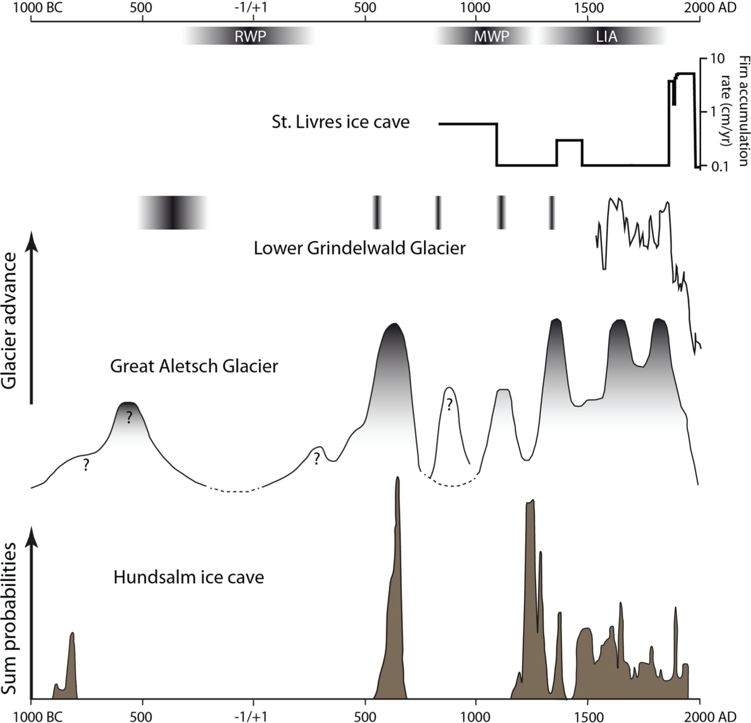
Calibrated radiocarbon ages of wood remains from Hundsalm ice cave (sum of entire 2σ probability distribution) compared with the long-term mass changes of the Great Aletsch Glacier and Lower Grindelwald Glacier in the Western Alps (Holzhauser et al., 2005). The latter data consist of a continuous curve back to the early 16th century and a discontinuous record of advances marked by vertical bars.
One aspect sticks out in the comparison between the two Alpine glaciers and Hundsalm, that is, the lack of wood fragments from the two prominent warm periods in the last three millennia, the RWP (c. 250
All wood samples recovered so far are from periods in the past when the climate in the Alps was more ‘glacier-friendly’ than today (Figure 6). Four samples were preserved in cave ice between the 6th and 7th century
The youngest part of the LIA is represented by four samples whose calibration range overlaps with the modern radiocarbon range. Although these data are less reliable than the rest of the samples, they nevertheless provide hints on snow and ice accumulation during the later centuries of the last millennium. There are actually more samples to be expected representing these last few centuries during which the Alpine glaciers experienced their largest extent in the LIA. The apparent scarcity of wood remains from this youngest period, however, is due to the preferred sampling (accessibility) along the lower and older part of the firn and ice body in this cave.
No information is available for earlier cool periods, except for one sample which falls at the end of the Bronze Age and coincided with the onset of a long-term ‘glacier-friendly’ climate interval as recorded by the Great Aletsch Glacier (Figure 6).
We also compared the Hundsalm data with St Livres ice cave located in the Jura Mountains of westernmost Switzerland. This is the only other ice cave in the Alpine realm with a large database of wood samples spread over a c. 6-m-thick firn succession (Stoffel et al., 2009). Dated mostly by dendrochronology and partly by radiocarbon, the St Livres data were converted into a firn accumulation rate in Figure 6. This record shows a prominent maximum during the second half of the 19th century and the beginning of the 20th century partly affected by artificial abstraction of ice for industrial purpose probably starting in the 17th century (Stoffel et al., 2009), and less pronounced changes in accumulation during preceding centuries. No clear-cut correlation of this record with either west Alpine glacier sizes or the Hundsalm wood record is evident for the last millennium. This is unlikely due to uncertainties in the individual records and may at least in part reflect differences in precipitation (less likely so in temperature) between the Alps and the adjacent Jura Mountains. It certainly underscores the need to study more ice caves in this area to retrieve valuable centennial- to millennial-scale information before these underground deposits disappear.
Conclusion
Perennial firn and ice deposits in caves are among the least well-known components of the cryosphere; yet, they may hold valuable palaeoenvironmental proxy information extending back several millennia. Sag-type, ice-filled depressions in karst regions are particularly interesting as these caves acted as traps open to the surrounding landscape. Hundsalm ice cave in the Austrian Alps is such an example. Located in a forest, the shafts of the cave allowed wood and other types of organic matter to enter the cave and to become embedded in the snow and ice. Based on a comprehensive set of radiocarbon-dated wood fragments retrieved from the lower portions of the firn and ice body, constraints can be placed on the accumulation and ablation history of this cave ice. We found evidence of strongly reduced firn and ice during the RWP, clear indications of firn and ice build-up during the 6th and 7th century
Footnotes
Acknowledgements
CS thanks K Nicolussi for identifying some of the wood fragments and acknowledges logistic support by the Landesverein für Höhlenkunde Tirol. Comments by four journal referees helped very much to improve and clarify the paper.
Funding
Part of the radiocarbon analyses were funded by a grant of the Swarovski Foundation.