
Abstract
This study focuses on the recurring climate conditions required for the largest storms occurring in NW France (Brittany). It is based on the analysed records of storm events along Western Brittany coast (see Part I). In this manuscript (Part II), storm recurrence is explored along with forcing mechanisms. Periods of more frequent storm events over the two last centuries are analysed first in order to link these events with possible forcing mechanisms (North Atlantic Oscillation (NAO) and Atlantic Multidecadal Oscillation (AMO) modes) triggering the most destructive storms. Then, palaeostorm events are discussed at the Holocene scale, from 6000 yr BP to present, to verify the forcing mechanisms. Most recorded events appear to be linked with cooling episodes, mostly in winter, a transition to or from a negative winter NAO mode, a positive AMO mode. Extreme storms occur immediately prior to the ‘Medieval Warm Period’ (MWP). Maximum effects are reached prior to the onset of the MWP and during the Maunder and Dalton solar minima. Low storm activity occurred during the Spörer Minimum linked to an acceleration of the Atlantic Meridional Overturning Circulation (AMOC). Main storm triggers seem to correspond to a positive AMO mode with an unstable jetstream configuration driving a negative NAO. In this study, four specific weather configurations were defined to explain each type of recorded storminess. The strongest storms correspond to low AMO and decennial-negative NAO modes (e.g. ‘Little Ice Age’), or high AMO in association with dominant low NAO modes, as during the early Middle Age and present-day period. Fresh or warm oceans in association with a positive NAO mode are stormy but with very low sting storms frequency. Although in agreement with the orbital forcing and the Holocene glacial history, increasing storm frequency and intensity is most probably partly biased by continuous sea-level rise and resulting erosion.
Keywords
Introduction
Brittany coasts, and especially the Bay of Audierne (BA; Figure 1), are some of the most exposed western France coasts to storms and flooding risk. The NNW–SSW coastline of the bay is exposed to the western Atlantic fetch, particularly during SW and NW storms. Morphogenetic impacts will be even greater when several effects are combined: high tide, storm surges and recently formed high waves (Bertin et al., 2012; Wolf, 2009). Several historical storms (age Anno Domini, i.e.
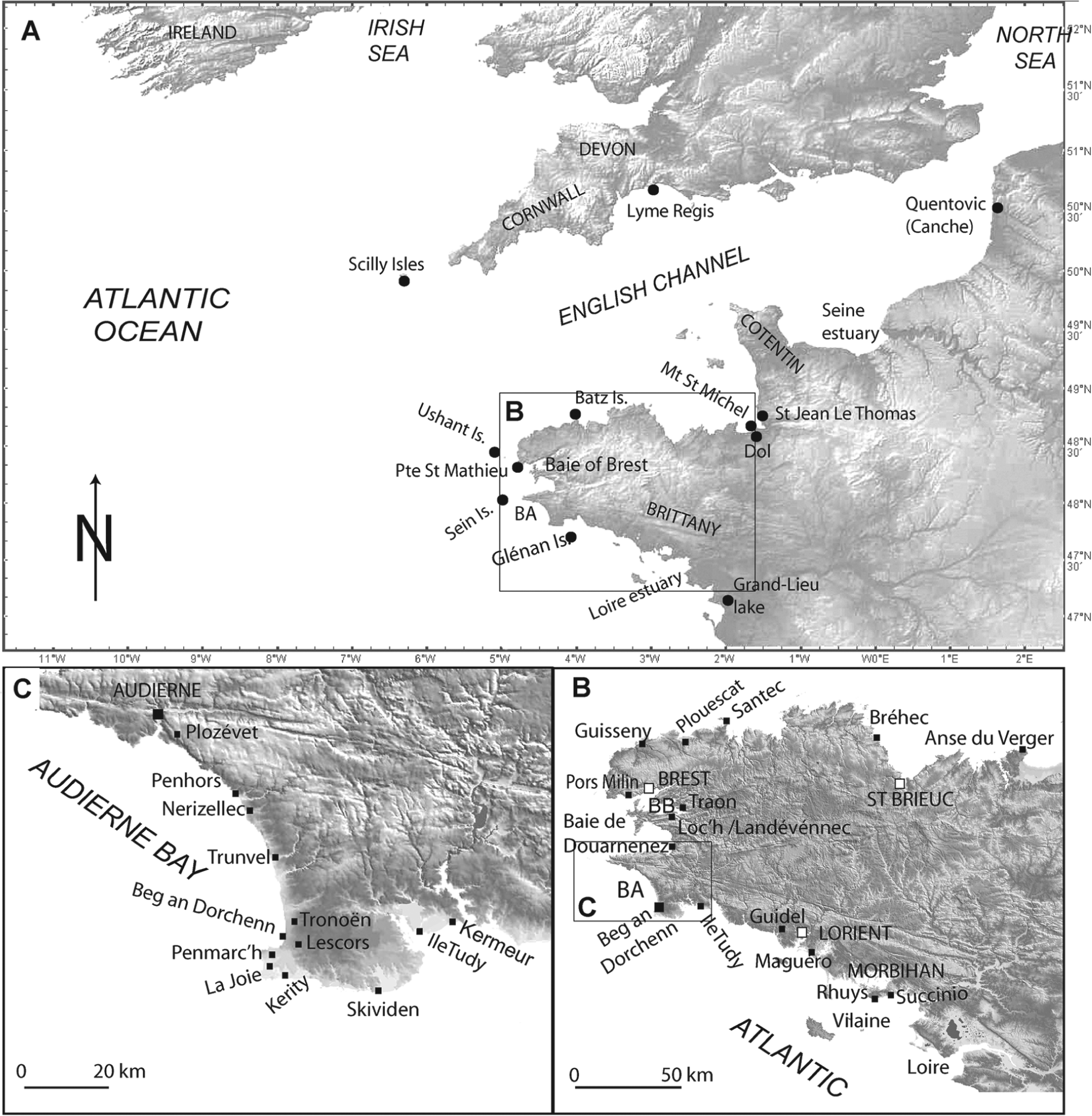
Location of sites discussed in the manuscript and of stations recording the main storm events in the Armorican Massif but also when considering Western Europe.
New data obtained around Brittany (cf. ‘Middle- to Late-Holocene Storminess in Brittany (NW France): Part I’) have been implemented with older regional observations (cf. Figure 1), so as to depict a regional overview of relative sea-level changes (Goslin, 2014; Goslin et al., 2013) as well as storminess trend recorded after the Holocene thermal optimum in Brittany (this study). For the present study, past storm events were extracted from archives (Table 1), while radiocarbon dates from Brittany and adjacent regions, especially in the Bay of Audierne and Bay of Brest (Figure 1), were also available (Table 2). The storm recurrence is first analysed over the two last centuries in order to link these events with possible forcing mechanisms (meteorological records; North Atlantic Oscillation (Hurrell, 1995), referred to as NAO in the following text; and Atlantic Multidecadal Oscillation, referred to as AMO in the following text) triggering the most destructive ones. Then, the palaeostorm events are analysed for the periods older than these covered by meteorological instrumental data, by comparing them with sea surface temperature (SST) and sea-ice cover extent reconstructions, NAO proxies and solar and volcanic activity. In a first step, we discuss the historical period (from 100
Listing by century of the recorded storms in various archives (see the text).
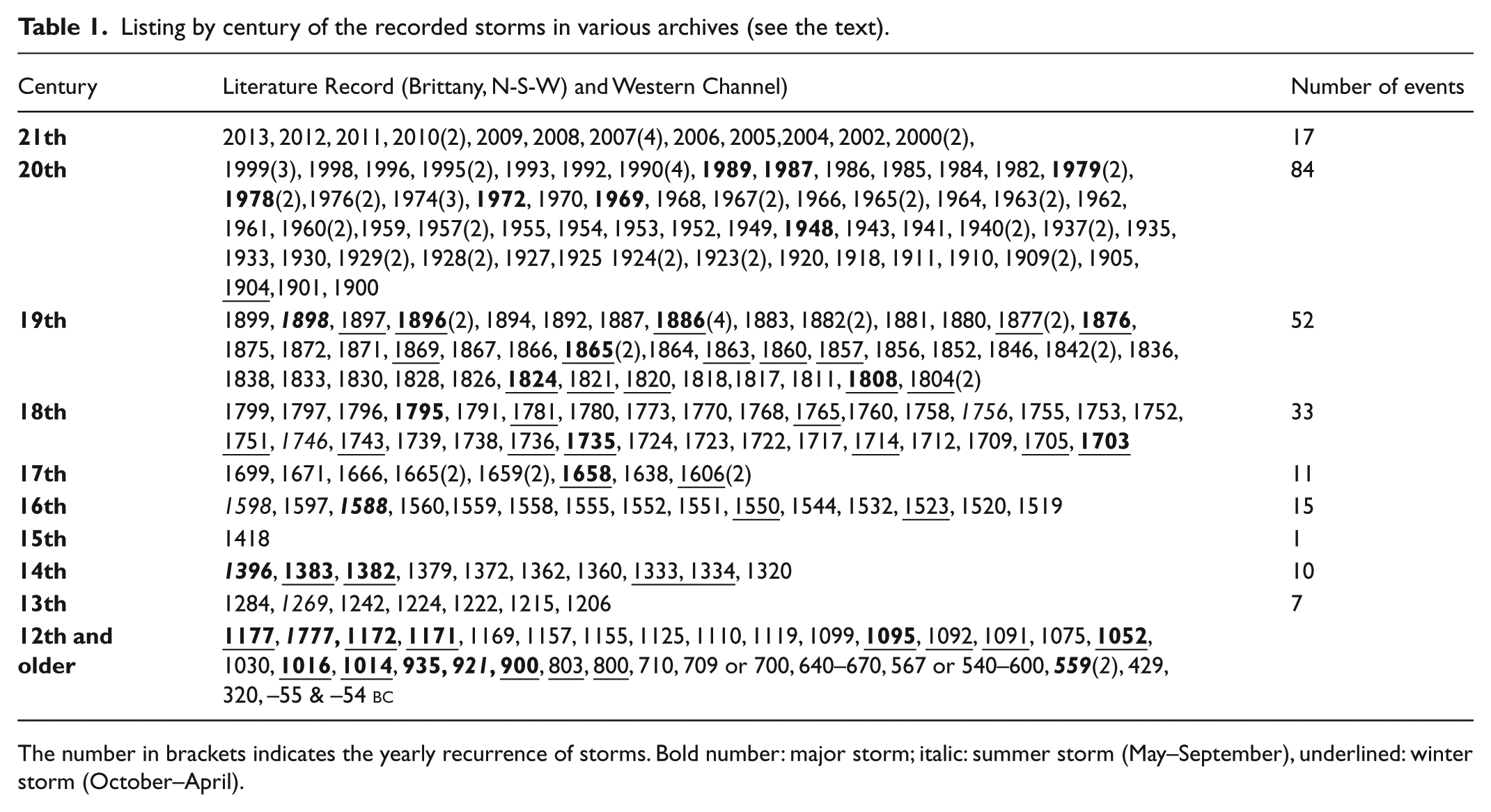
The number in brackets indicates the yearly recurrence of storms. Bold number: major storm; italic: summer storm (May–September), underlined: winter storm (October–April).
List of all 14C dating discussed in the manuscript.
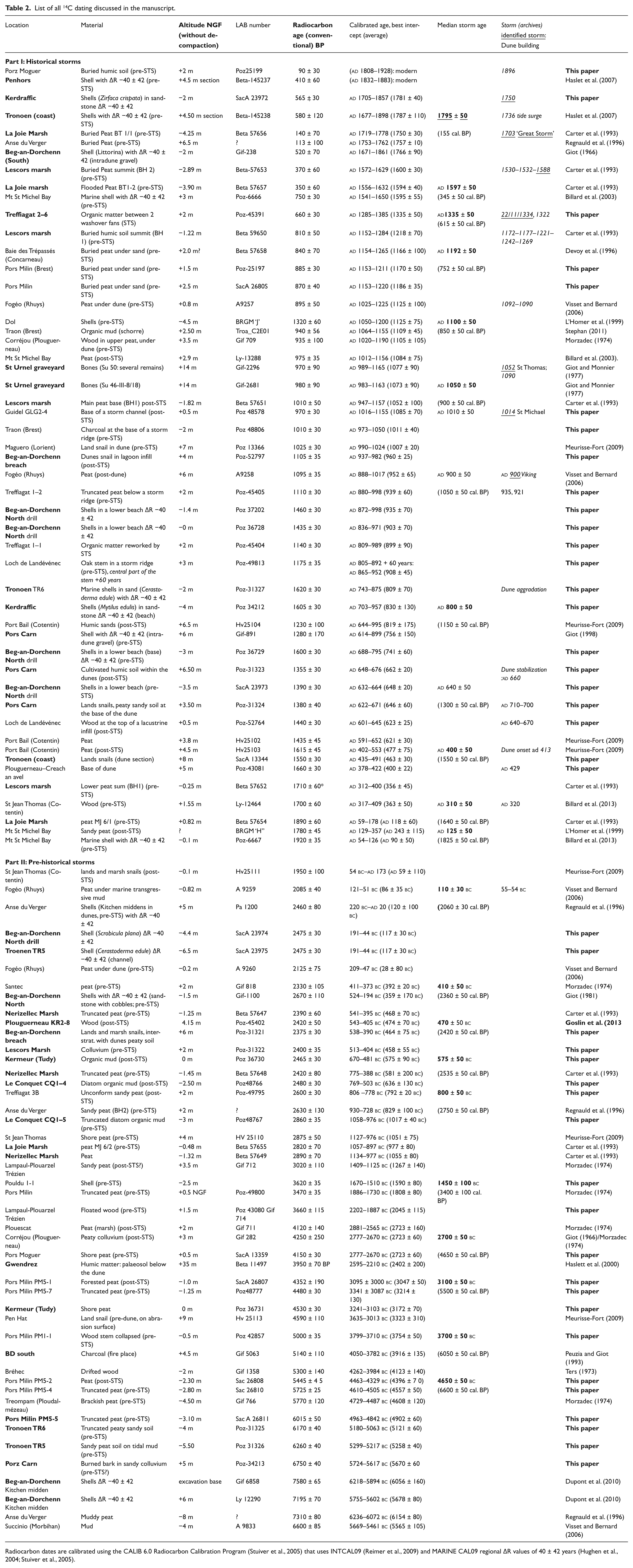
Radiocarbon dates are calibrated using the CALIB 6.0 Radiocarbon Calibration Program (Stuiver et al., 2005) that uses INTCAL09 (Reimer et al., 2009) and MARINE CAL09 regional ΔR values of 40 ± 42 years (Hughen et al., 2004; Stuiver et al., 2005).
State of the art
Present-day context: storm genesis versus NAO mode
European storms commonly occur during the ‘winter period’ from late September to April. Storm impact is primarily linked with wind strength as well as swash efficiency. Westerly wind strength is, in Europe, a crucial parameter acting on monthly wave heights. Furthermore, wave heights are more dependent upon storm tracks, storm age (Bertin et al., 2012) and rising wind speed (i.e. storm intensity; Wolf and Woolf, 2006). Repeated high tides during stormy periods (corresponding to clustered depressions) will enhance the morphogenetic impact associated with these storm events. Specific meteorological configurations, and especially the jetstream pattern, can also favour strong storm impact on Western European coasts (Alexander et al., 2005). Indeed, sting jets (such as the 1987 Great Storm; Browning, 2004) accelerate the deepening and rotation of the depression cell (Alexander et al., 2005; Browning, 2004) leading to freshly formed aggressive waves (Bertin et al., 2012), also favoured by a strong gradient in SST (Sanders and Gyakum, 1980).
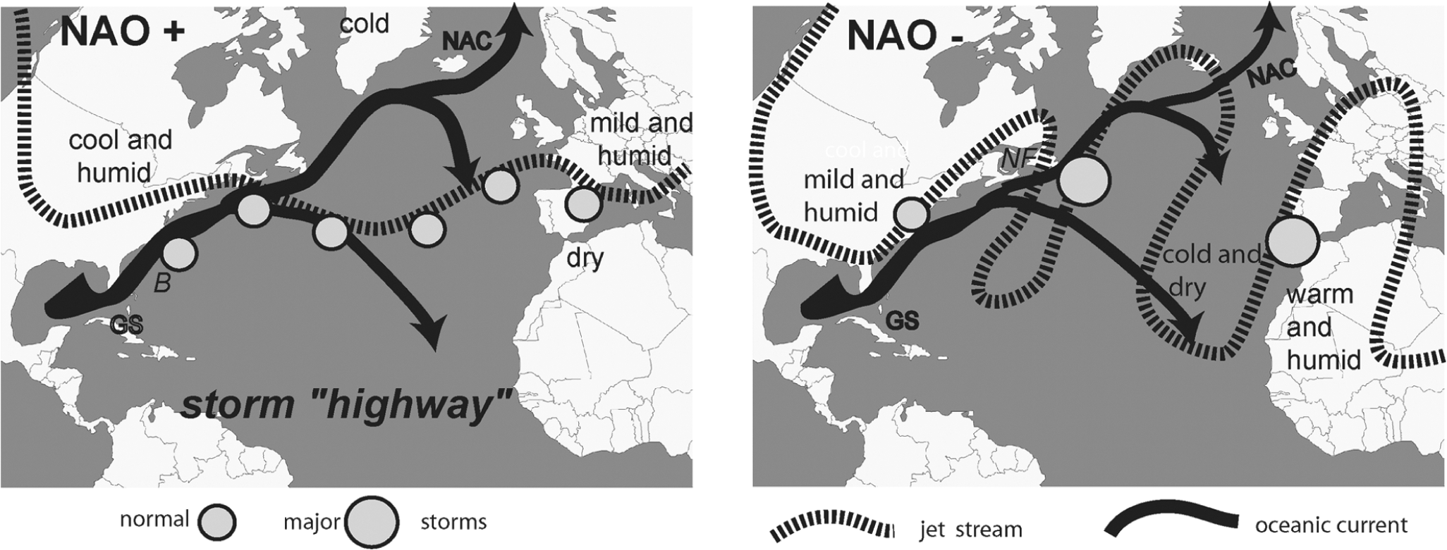
Many studies suggest, for the pre-industrial period, a fair correlation between Northern Hemisphere climate changes and solar activity (e.g. Bond et al., 2001; Chapman and Shackleton, 2000; Mayewski et al., 2004). Furthermore, solar activity is potentially one of the drivers of the NAO variability (Abreu et al., 2012; Alvarez-Ramirez et al., 2011; Beer and Van Geel, 2008; Ineson et al., 2011). Specific NAO modes, considered to be winter phenomena, are then associated with periodic reorganization of the atmospheric and oceanic circulations in the Northern Hemisphere. During a positive decadal NAO mode, winter conditions are usually wet and rainy over NW Europe, with series of storms characterized by prevailing W–E tracks (Dawson et al., 2003; Pirazzoli et al., 2004; Rodwell et al., 1999). During a negative decadal NAO mode, cold and dry winter conditions generally prevail above NW Europe, due to the disappearance of the Westerlies (Dickson et al., 1996; Orford et al., 2000). In this schematic Northern Europe view, NAO pattern and storminess events appear to be stronger during a negative NAO mode due to the abrupt atmospheric front occurring between tropical and arctic air masses (Ayrault, 1998; Betts et al., 2004; Trouet et al., 2012). Indeed, a positive NAO mode will induce stable westerly situation and gently undulating jet streams, while a negative NAO mode will induce marked instability raised by an important swing of the jetstreams. NAO and storminess are also impacted by sea-ice cover changes in the Northern Hemisphere (Figure 2; Courtenay et al., 2009; Jaiser et al., 2012).
Synoptic scheme of the classical storminess patterns linked with NAO mode.
For the following discussion, it is important to note that we will sometimes refer to ‘hurricanes’ or to ‘tropical storms’. Depressions born in a few hours from instabilities above the Bermuda Islands (Atlantic Ocean; hottest Gulf Stream waters) represent most of the storms discussed in this paper (Figure 2). However, the specific term ‘hurricane’ will be only used for hot storms coming from Africa through the Gulf of Mexico, mostly in early autumn, while the term ‘tropical storms’ will be used for storms directly rising from Africa to Europe due to an anomalous configuration of the North Atlantic jet (NAJ) streams (negative NAO; Figure 2).
NAO: From a daily to a millennial signature?
At the Holocene timescale in NW Europe, drought and dune building would be associated with repeated centennial NAO negative modes and moderate storms (Lamb, 1995). Recurrence of negative NAO configurations may have persisted long enough (few winter months) to modify temporarily the wind pattern, such as those observed during the late 20th century (Visbeck et al., 2001) with dominant westerly winds in Brittany (Hénaff, 2008; Pirazzoli et al., 2004). Over longer timescales, colder (2310–2190 cal. BP,
In this paper, we will also verify the NAO mode control on storminess, as commonly considered and published for the last millennia (Cook et al., 2002; Dawson et al., 2007; Trouet et al., 2009). References to daily, decadal or centennial NAO events will be used according to the duration of the period considered in this study.
Another mode of natural atmospheric variability: The AMO
The AMO shows longer periodicities (around 60–80 years) than the NAO (around 10 years). The AMO signs the thermal storage in the basin-wide Atlantic Ocean (Otterå et al., 2010; Schlesinger and Ramankutty, 1994) transmitted to the Northern Atlantic by the Gulf Stream (meridional heat flux and thermohaline circulation; Hoskins and Hodges (2002)). The AMO fairly records SST changes in the North Atlantic driven by insolation processes such as atmospheric circulation patterns, the Atlantic Meridional Overturning Circulation (AMOC), and sea-ice extent (Knudsen et al., 2011). The AMO, in turn, also strongly affects temperature variations over Europe (Goldenberg et al., 2001; Knight et al., 2006; Sutton and Hodson, 2007; Zhang et al., 2006).
Therefore, the AMO control will also be considered through its impact on SST, a concept very similar to the actual understanding of tropical hurricane triggering from a warm ocean and migrating above high SST (Goldenberg et al., 2001). Following what we presented above concerning NAO and AMO configurations, maximal storminess would be expected in a context of very high SSTs (positive AMO mode) combined with unsteady NAO mode (Figure 2). This hypothesis has been already proposed by Barlow et al. (1993) and also fits the Atmospheric General Circulation Model by Graff and LaCasce (2012). It supports the idea that storm tracks respond to changes in mean SST and that increasing the SST gradient at mid-latitudes causes an intensification and a poleward shift of the storm tracks, in response to a poleward shift of the jet stream (http://squall.sfsu.edu/crws/jetstream.html) and a high pressure blocking (Açores High). Moreover, storm strength increases monotonically with the magnitude of SST perturbations driven by the latent heat release (Booth et al., 2012).
For historical and pre-historical times, AMO intensity can be indirectly extracted from sea-ice cover extent and SST reconstructed north of Iceland (Berner et al., 2008). Indeed, these SSTs are linked with the intensity of the Irminger Current, a branch derived from the North Atlantic Drift, itself directly connected to the Gulf Stream (Jennings et al., 2000). For this reason, this approach cannot be applied before the total disappearance of the Laurentide Ice Sheet, due to perturbation of the SST by melt waters.
Methods
The reader is referred to the first part of this paper (‘Middle- to Late-Holocene Storminess in Brittany (NW France): Part I’) for the methodological part concerning the occurrence of Holocene major palaeostorm events recognized in Southwestern Brittany (archives, stratigraphical works; Tables 1 and 2). This study was implemented with other sites (observations/publications), in connection with the storm record. Altitudes are given in NGF, the French National Geodetic level.
Event’s detection
Regional storm events during the 19th–20th centuries are extracted from various sources: public and administrative archives, press and vernacular archives analyzed by local historian, often available on the Internet. Historical archive data are mainly derived from the Anglo-Saxon Chronicles and from Caesar’s De Bello Gallico. A compilation of historical events from
Furthermore, from a stratigraphical view, 47 dates from Audierne/Ile-Tudy sectors (cf. Figure 1) and 35 other pertinent dates from Brittany (Table 2) are considered. Calibration of all dates was performed at one or two sigma using the CALIB 6.0 Radiocarbon Calibration Program (Stuiver and Reimer, 1993; Stuiver et al., 1998), associated with the non-marine (IntCal09) or marine (Marine09) radiocarbon calibration (Reimer et al., 2004, 2009). For accommodating local effects, a regional marine reservoir correction Δr of about 40 ± 42 years (Sein Island; Hughen et al., 2004; Stuiver et al., 2005) has been applied.
Palaeostorm events identified and dated will be discussed in parallel with centennial NAO reconstruction, total solar irradiance (TSI) reconstruction and volcanic activity. Furthermore, SST reconstructions (Northern Iceland, REF) as well as sea-ice cover extent (chloride concentration in GISP2 ice core; Alley, 2004) will permit us to discuss possible links with different stages of AMO configuration prevailing during major palaeostorms. Given the large set of different information, we did not apply statistical analysis to discuss storm’s dating together with reconstructed NAO and AMO.
Event’s timing
Regional storminess events extracted from archive data are listed in Table 1. Combining these with the events extracted from the stratigraphical record (‘Middle- to Late-Holocene Storminess in Brittany (NW France): Part I’), it becomes possible to define a list of severe palaeostorms that occurred around Brittany (Table 2). When considering storm timing, the median (best fit) of whole congruent Brittany’s dating is used with an average error of ±30–100 years, taking into account the age of the sample in pre- or post-storm surge position (pre- or post-STS; Figure 3). This analysis has been extended to whole Brittany with the new data of Goslin (2014; Goslin et al., 2013) and previous published studies (cf. Table 2 to see all 14C dating taken into account in this study).
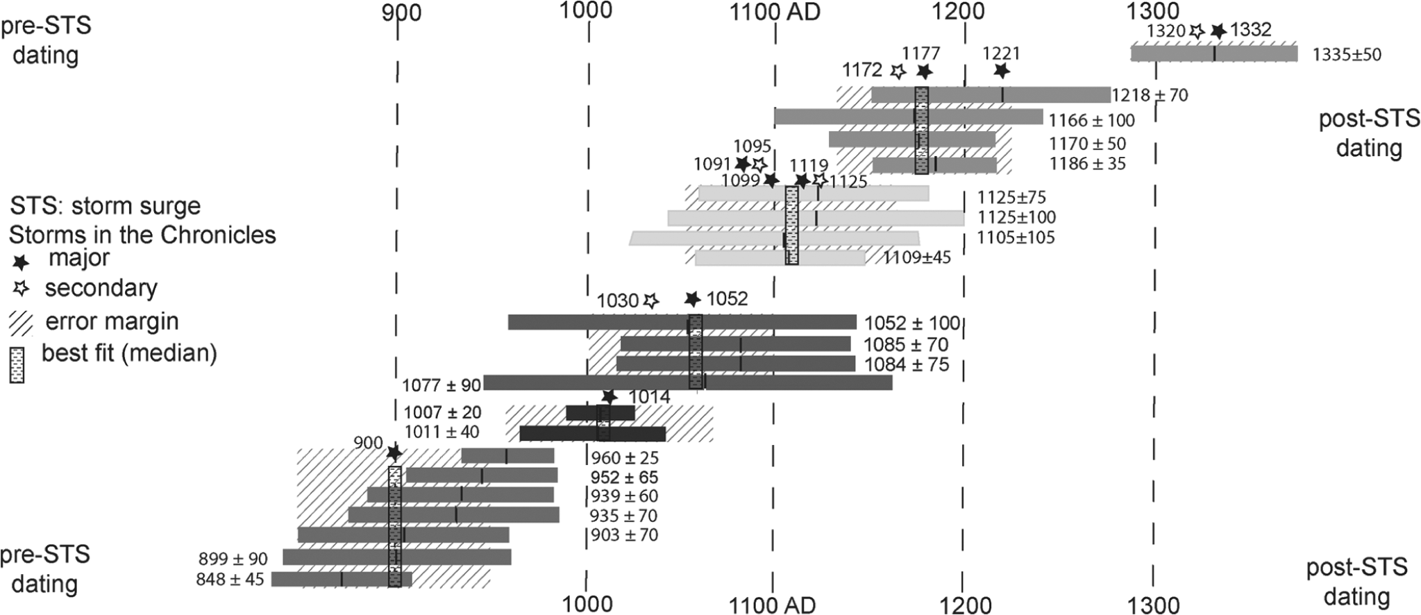
Analysis of the median for the 9th–12th century storms. Stars represent known storms (archives).
For the historical period, the ages discussed are expressed in
For the pre-historical period, that is the Holocene long-term record from 7000 cal. BP to present, archives are not available. This stratigraphic work gives access to storm ages of about: 6600 ± 50 cal. BP, 6050 ± 50 cal. BP, 5500 ± 50 cal. BP, 4650 ± 50 cal. BP, 3400 ± 100 cal. BP, 2750 ± 50 cal. BP, 2535 ± 50 cal. BP, 2360 ± 50 cal. BP and 2060 ± 30 cal. BP, and periods close but somewhat different from those observed for the Mediterranean Sea: 6300–6100 cal. BP, 5650–5400 cal. BP, 4400–4050 cal. BP, 3650–3200 cal. BP, 2800–2600 cal. BP and 1950–1400 cal. BP (Sabatier et al., 2012).
Results: Palaeo-storms record from the middle to the late Holocene
In the following paragraphs, we will refer to age
Regional storminess record: 1850 to present
A first comparison, over the two last centuries, between storm recurrence in Brittany extracted from archives (Figure 4 and Table 1), NAO and AMO natural variability extracted from the Climatic Research Unit (CRU, University of East Anglia, UK), suggests a link between high storm frequency, positive AMO values and the onset of a NAO shift from a positive to a negative mode or inversely. Indeed, three periods of lower storminess frequency are recorded around 1850–1864, 1884–1894 and 1925–1943, and correspond to thermal minimum of AMO cycles (Figure 4), even some periods have a low validity storm record (wars period). Storm frequency is high as well with negative or positive NAO, but higher when the maximum of the AMO cycle is reached. Regional storminess seems therefore connected to a warm Northern Atlantic Ocean, associated with a thermally unstable North Atlantic air mass. This situation results from the swing of the NAJ stream that causes an abrupt contact between polar and tropical air masses (Figure 2)
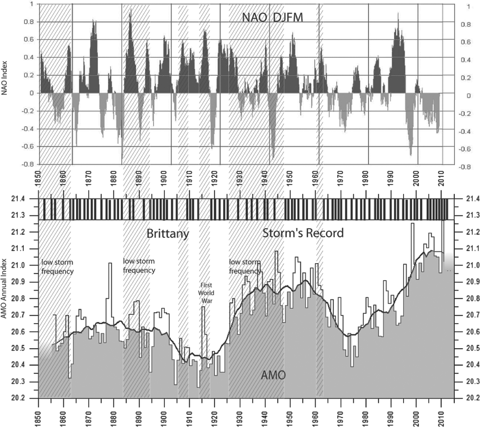
Comparison of the archive storminess record in Brittany (cf. Table 1), the winter NAO index (CRU, E. Anglia, UK) and the AMO (CRU, E. Anglia, UK).
As a recent example, the decadal NAO was mostly negative during the cool interval 1960–1976, further shifting to two decades 1976–1996 (solar cycles 21 and 22) dominated by positive anomalies (Rind et al., 2005; Thompson and Wallace, 1998; Visbeck et al., 2001), before shifting back to negative anomalies from 1996 to now (Figure 3). Here, the minimum in regional storminess is recorded from 1960 to 1964, during an interval indeed characterized by low AMO anomalies with mostly positive NAO anomalies. In opposition, taken also as example, Xynthia (in 2010) tropical storm track had a southern origin and was driven by enhanced swing of the NAJ streams. It occurred as a brief positive event within a period characterized by a dominant negative winter NAO mode. Joachim storm (15 December 2011) and the Great Storm (17 October 1987; Browning, 2004) occurred under similar conditions and were preceded by tropical air. Pinto et al. (2009) stressed that, for the recent period, storms mostly develop during a daily positive NAO anomaly within a monthly to yearly negative NAO mode. The process is probably similar at longer (decadal or centennial) timescales: brief heat input or magnetic perturbation that may be induced by solar eruption would temporarily destabilize the climate system by modifying the thermal budget (Damé, 2013; Mendoza, 2005).
For the last 30 years, the AMO index raised more and more positive to reach its maximal value in 2012, about 50 years after the maximum of the major solar cycle 19 (1958–1964). The NAO index turned to dominant negative values, mostly from 1995 (NOAA web site). The Arctic atmosphere is thus, today, in thermal contrast with the warm Northern Atlantic Ocean (Knudsen et al., 2011), resulting in a regional increase in storm frequency from 2004, with the onset of regional destructive storms from 2007. It seems thus possible to consider an analogous mechanism for storm triggering as well as for hurricanes. Here, it would imply rapid atmospheric instabilities (more frequent NAO anomalies), raised by the NAJ streams, over a warm ocean (accentuated convection), within a shift from or to a decadal negative NAO mode. Therefore, the driver is the thermal status of the ocean (Figure 4) and an unstable jet stream pattern driven by decadal negative NAO mode.
Historical storms: 100 bc to present
Close to 110
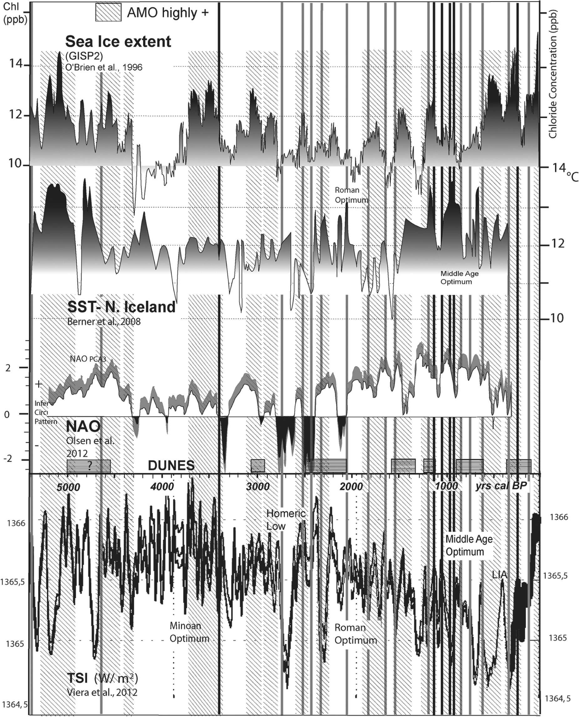
Comparison between storms (red: important, blue: major) and dune formation events in Brittany, total solar irradiance (TSI; Vieira et al., 2011), NAO (Olsen et al., 2012), SST off Northern Iceland (Berner et al., 2008) and sea-ice extent (O’Brien et al., 1996).
The regionally observed
On the northern coast of Brittany, the recorded
A major storm struck around
A number of events with a very strong morphogenetic impact occurred in the 11th century, around
From the details above, it appears evident that the series of major storms, mostly winter storms (Table 1) from
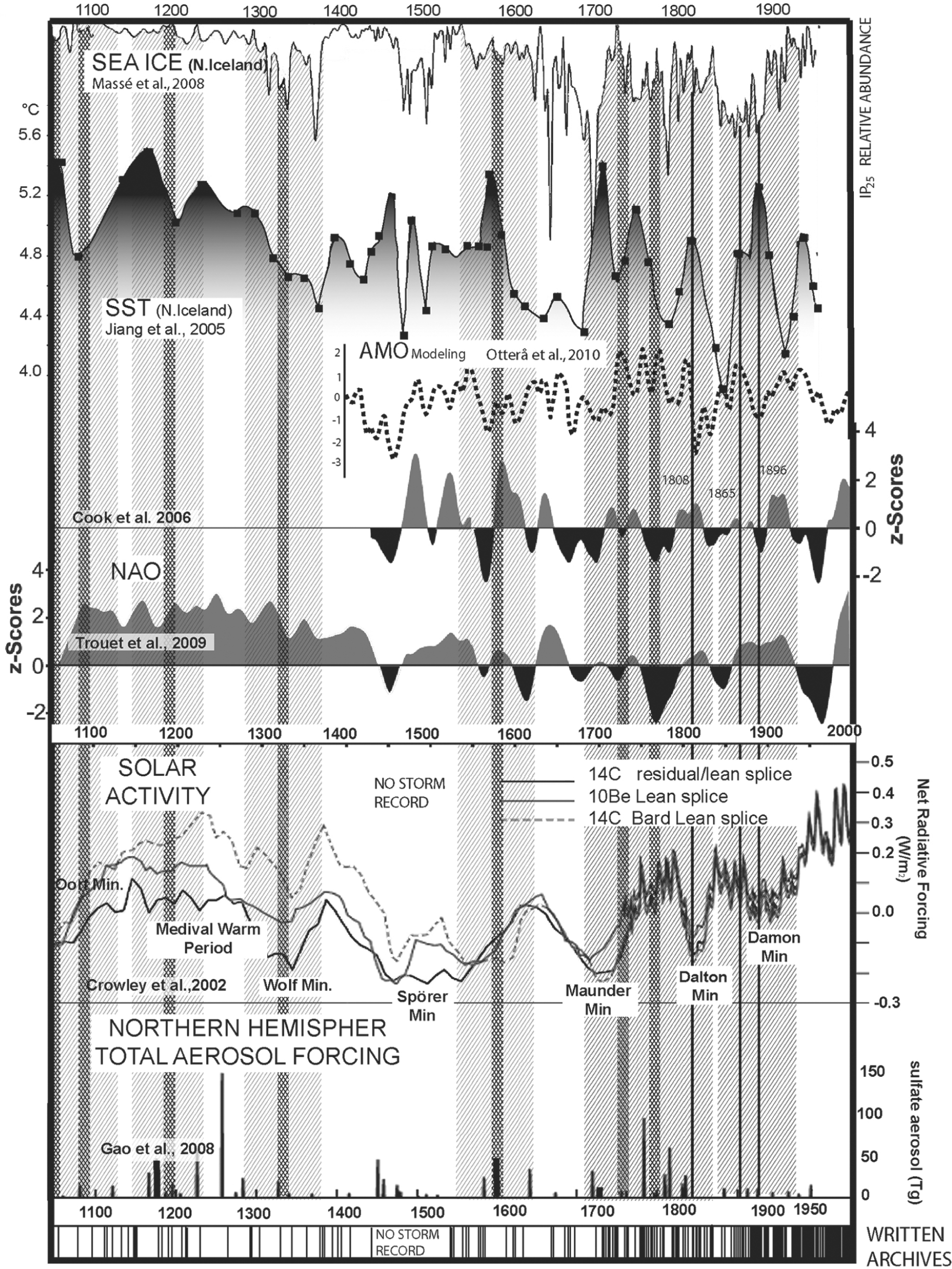
Comparison between the geological storminess record (dark gray bars underline major storm episodes and light gray bars highlight error bars), written storminess archives, and three sub-recent storms (black vertical lines), in parallel with: NAO (Trouet et al., 2009) and AMO modelling (Otterå et al., 2010), North Iceland SST (Jiang et al., 2005), sea-ice extent off Northern Iceland (Massé et al., 2008), solar activity (Crowley and Lowery, 2000) and volcanic forcing (Gao et al., 2008).
The ‘Medieval Warm Period’ (MWP) differs in timing according to the region considered but classically ranges from
From
During the 16th century, a main storm is recorded in Western and NE Brittany close to
In the 19th century, the last historical storms recorded in the sedimentation at the BA are compiled from the literature, given the limitation of dating by the 14C plateau effect. The timing is mostly extracted from coastal erosion record. Four winter storms may be extracted from archives (Table 1): 11–12/02/1808 (the ‘century’ storm), 11/01/1866, 16/12/1886 and 4/12/1896. The coastal retreat at the BA was probably also enhanced by the ‘Great Gale’ (22–23/11/1824) that devastated the southern coast of Britain (West, 2010 (web reference)). It mostly reached the coasts of Brittany with south-westerly winds. In 1839, 1865/1896 and 1897, storm series breached the dunes of Kerity (Penmarc’h; Monfort, 1985); the Lescors marsh became filled with drifted sands, Kerity and La Joie marshes were flooded. The climate was initially cold (Dalton Solar Minimum, 1790–1830), and glaciers began to retreat from 1830 with milder conditions than for the main ‘Little Ice Age’ (LIA) phases. Most of large 19th century storms are associated with high SST (Figure 6) and a transitional NAO mode. A high AMO mode is suggested by the annual index (Figure 4) but a low one is inferred from modelling exercises (Otterå et al., 2010).
Pre-historic to historic storms: 6000 cal. BP to present
In this part, the validity of the observations previously made at historical timescales is tested, at the Holocene timescale. However, dating is not always as accurate as previously and data are rare. Centennial NAO reconstructions only exist from 5500 cal. BP to present (Olsen et al., 2012). AMO oscillations are deduced from North Iceland SST as well as sea-ice cover extent for the same periods.
More evidence for an early storm event are recorded around 6600 ± 50 at Pors Carn (Table 2). Then, one isolated south-westerly storm is recorded at 6050 ± 50 cal. BP at Pors Milin (Table 2), through a lagoon submersion. However, reliability is low given the available dating over these periods (storms not represented in Figure 6). This time interval is synchronous with a marked cooling as suggested by the glaciological chloride record of GISP2 (cf. O’Brien et al., 1996).
Storms events in Brittany are recorded around 5500 ± 50 cal. BP (Table 2 and Figure 4), mostly on the western coast of Brittany. The onset of dune building after 5500 cal. BP at Gwendrez and the breaching at Kermor (cf. Figure 1c) close to 5150 cal. BP should probably fit several storm events within this time range. This period seems also responsible for a storm terrace reaching 6–7 m NGF around 5400 ± 50 cal. BP in the Canche estuary (Meurisse-Fort, 2009; cf. Figure 1a), as well as storm impact records obtained in the Seine estuary (Sorrel et al., 2009; cf. Figure 1a) and Mont-Saint-Michel Bay (Tessier et al., 2010; cf. Figure 1a). From the chloride curve of GISP2, sea ice appears limited between 5850 cal. BP and 4950 cal. BP (O’Brien et al., 1996; Figure 5), in parallel with high SST off Northern Iceland (Berner et al., 2008; Figure 5). This period would correspond to high positive AMO, while centennial NAO values seem rather low (Olsen et al., 2012; Figure 5). Another storm is then recognized in North and Western Brittany at 4650 ± 50 cal. BP.
Consecutively, this new record for Brittany shows a major storm episode centred around 3400 ± 100 cal. BP (Table 2 and Figure 5). It would fit with the 3450 ± 50 cal. BP storm, initially published by Guilcher and Hallégouët (1991) and by Carter et al. (1993) and also preserved in the Bay of Vilaine, the Mont-Saint-Michel Bay (Billeaud et al., 2009; Tessier et al., 2010) and the Seine estuary (Sorrel et al., 2009). The impact of increased storminess around 3450 cal. BP has been more widely recognized at the European scale, but few data are commonly preserved onshore, due to the progressive sea-level rise and resulting erosion. This period would correspond to a cooling with an important Arctic glacier extent (Denton and Karlén, 1973; Nesje et al., 2008), following the Minoan Thermal Optimum (Figure 5). It could be interpreted as millennial scale storm(s) occurring during a centennial NAO shift to negative values; SST remain however high and could be related to a former peak of TSI (Steinhilber et al., 2009; Vieira et al., 2011). The AMO is therefore presumed positive from SST and sea-ice extent data, while the centennial NAO seems to shift towards negative values (Figure 5).
Other events are then recorded at 2750 and 2535 ± 50 cal. BP at Audierne and along the Western coast of Brittany. The 2750 ± 50 cal. BP corresponds to a deep solar low (Vieira et al., 2011), known as the Homeric Low (Figure 5), with a large archaeological and palaeoecological European impact (Van Geel et al., 1996). Over this interval, storms occur during a cooling spell (high sea-ice extent; Figure 5) when the centennial NAO is already mostly negative but not strong (Ólafsdóttir et al., 2013); SST north of Iceland are however still high (Berner et al., 2008). The 2535 ± 50 cal. BP storm event seems also connected with a deep solar low, a rise in SST and NAO negative values with extensive sea-ice. Finally, the 2420 ± 50 cal. BP and 2360 ± 30 cal. BP storm seem to proceed from a situation already described above: High SST, reduced sea-ice (potential positive AMO) and shift of the NAO to more positive values.
Discussion
Paralleling various climate forcing with storm occurrence
The last 7000 yr BP are characterized by significant changes in climate. Greenland sea-salt data (cf. GISP2; O’Brien et al., 1996) are consistent with storminess, Northern Hemisphere glacial expansions (Denton and Karlén, 1973) and solar forcing (Bond et al., 2001). Storminess in Brittany, in a first approach, appears linked to cooling events. However, comparison between storms, NAO and AMO modes, as well as SST reconstructions, shows a much more complex system. No direct link between storms and negative NAO events intensity has been demonstrated (Burningham and French, 2012). From this storminess analysis for the 20th century (cf. Figure 4), we suggest that major storms, mostly winter events, may correspond very often to marked NAO transitions in a general positive AMO context (warm ocean surface, cf. Figure 5): brief positive NAO incursions within a negative mode period, or inversely. This is true for very recent events.
The storm formation area in the Atlantic mostly corresponds to the Gulf Stream path, commonly associated with high SST. Jet streams also control instabilities in high altitude through the development of cyclonic cells. Moreover, the NAO mode strongly depends on the latitudinal position of the NAJ prior to the NAO onset (Luo and Cha, 2012). The northward (southward) shift of the NAJ from its mean position is a precursor to the NAO+ (NAO−) event. It appears thus that the present-day storms would occur, usually in winter, when cold air masses (mobile polar anticyclones; Leroux, 2010) interrupt suddenly the jet stream (CRWS Jet Stream Map), thanks to the southern position of the Azores High, leading to an abrupt energy reloading at the contact of tropical air with polar one (maps: California Regional Weather Server, http://squall.sfsu.edu/crws/jetstream.html). This is clearly the case for Xavier (5 December 2013, Christian, 2–31 October 2013). High wind speed, warm SST and sea-water spray by waves (cf. chlorides; O’Brien et al., 1996) can significantly increase surface heat exchanges (Zhang and Delworth, 2006), accelerating storm formation. This configuration would imply, for cyclone genesis, a daily positive NAO mode within a longer (decadal to yearly) negative NAO mode, responsible for the atmospheric instability. In this situation, cyclones migrate to the North and may be accentuated at the vicinity of polar anticyclone (Oruba et al., 2012). In addition, in this case, high SST in the western Atlantic would represent the main trigger for strong storm episodes, such as hurricanes (i.e. tropical storms; Goldenberg et al., 2001).
The NAO shifted to strongly negative and more instable behaviour at the onset of the LIA, after a long interval of mainly positive and rather stable NAO during the MWP (Olsen et al., 2012). Both the NAO and AMO cycles vary in time and length in lacustrine record from Iceland (NAO: 2–15 years; AMO: 5–130 years) throughout the last 3000 years (Ólafsdóttir et al., 2013). AMO cyclicity seems to be missing or shorter (35 years) during the LIA. This shift in cyclicity supports a reorganization of North Atlantic circulation during the coldest phase of the LIA (Ólafsdóttir et al., 2013; Trouet et al., 2012). When the jet stream migrates to the tropics in relation with a cooling activated by solar activity, storm tracks are derived to Southern Europe. The large increase in storminess or in cyclone intensity from the end of the Spörer Solar Minimum (Figure 6) probably results from the steepening of the temperature gradient within the Northern Atlantic area, as also revealed by sea-ice extent. It would correspond, especially for the period
NAO variance also increase in strength between
Synoptic scheme of storm formation in different contexts
On the basis of all the yielded observations and of recent weather data, we thus show that storminess seems well controlled by the solar energy input and its oceanic pacing (AMOC and SST). This is not due to chance, as already shown for extratropical storms through AGCM model (Graff and LaCasce, 2012). We managed to distinguish four situations, even if configurations are less obvious than those recorded above the tropical ocean (Figure 7). These four situations (Figure 7) may succeed in different orders but the extremes configurations 7A and 7D are never directly connected. Situation 2B would often precede situation 7A (Figure 7).
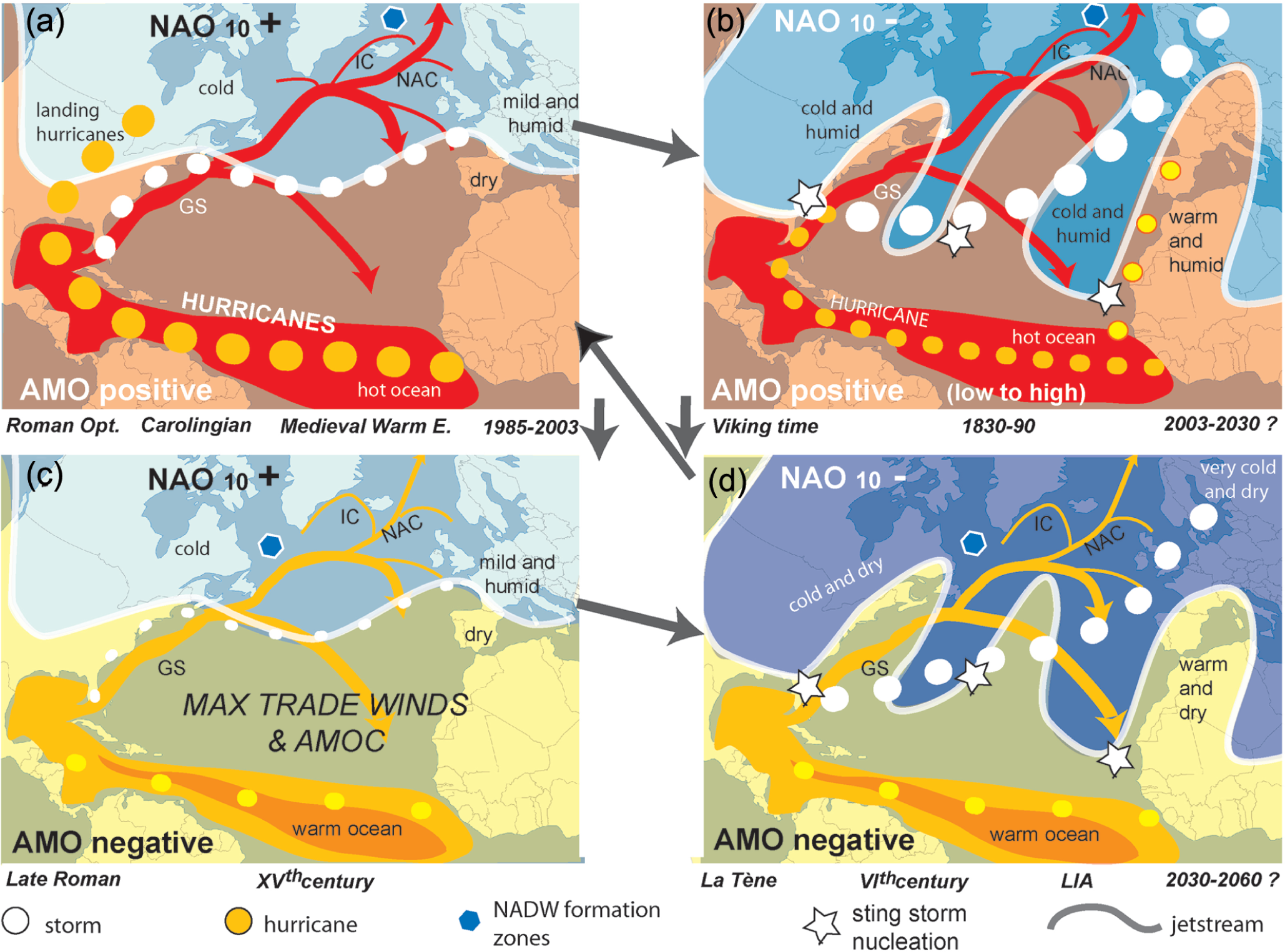
Synoptic scheme of the different storminess patterns linked with AMO and NAO 10.
(a) Positive NAO and AMO modes (Figure 7a) classically induce low intensity (<100 km wind speed) but regular westerly storminess in Western Europe (e.g. Pirazzoli, 2000; Visbeck et al., 2001). It results from a cyclone genesis in moist and warm air masses with low regional thermal contrast over the Bermuda. Winter is wet and rainy over Europe, with rare landing hurricanes in the United States. This is the situation during the late 20th century, the MWP, the Carolingian Period and the Roman Thermal Optimum from 100
(b) Unsteady NAO mode (low solar activity) combined with positive AMO mode (warm SSTs) allow the development close to Newfoundland (contact with the polar front) of SW–NW major storms reaching Western Europe (Figure 7b), with centennial raging ones. It results in an enhanced swing of the jet streams and important thermal contrast between the ocean surface and the polar jet. Enhanced cyclone genesis occurs in moist air masses with abrupt thermal contrast with polar ones, especially at the onset of cooling events. It is induced by warm SST anomalies driven by the Gulfstream, which accentuate the seasonal cyclone genesis on Newfoundland (Christian and Xavier storms, autumn 2013). This configuration is favoured by a slowdown in the AMOC, increasing the inter-latitudinal thermal contrast. Tropical storms may also reach Europe (direct shortcut along the West African coast as Xynthia (27 February–1 March 2010). Winter, and also summer, consist both in an alternation of a wet-stormy climate and cool-nice weather over Europe, as prior to the MWP and modern conditions.
(c) Negative AMO mode (low SST; Figure 7c) limits thermal exchanges and, thus, cyclone genesis. The AMOC, if accelerating, buffers inter-latitudinal thermal exchanges. European weather is rather quiet, depending on NAO modes, positive or negative, with jet streams more or less stable, respectively. This situation is rather rare and often brief.
(d) Negative NAO mode (Orford et al., 2000) combined with negative AMO mode (Figure 7d) raises a medium intensity storminess, with cold sea-surface waters and cyclone genesis generating in cold dry air masses (limited thermal contrast). Coastal aeolian activity is elevated in Europe, allowing coastal aggradation; and winter is cold, often foggy and dry. These climatic conditions can be interrupted by the sudden arrival of tropical air, leading to raging storms similarly to the LIA or the Dark Age cooling periods.
Limits to this method
We have to keep in mind that it is difficult to discuss storm events synchronously at the Northern Atlantic scale. Indeed, storminess seems to rise from
As a limit to this method, it is necessary to keep in mind that the geological record is incomplete due to the regional subsidence and the continuous sea-level rise, which contribute to the erasing of most of the early Holocene events (Goslin, 2014; Goslin et al., 2013). As a consequence, onshore, we do not identify a 1500-year cyclicity that would drive storminess (Sorrel et al., 2012; Viau et al., 2002). Nevertheless, the period usually poorly recorded in drilling with ‘low erosional stands’, induced by mid to low tide storms, seems well to approach this cyclicity (Goslin et al., 2013; Van Vliet-Lanoë et al., 2014, this issue).
Conclusion
From our study, we suggest that a warm sea-surface and cold Arctic winters are the main triggers for recent and old major storms. We therefore argue for a necessary NAO mode shift and/or cooling event (unsteady winter NAO modes) to trigger centennial or millennial largest storms, superimposed on a positive AMO mode trend, like hurricanes. A coherent answer is extracted from the comparison between recorded storm events and NAO reconstructions, as well as with SST and sea-ice cover extent offshore Northern Iceland, and solar forcing. Both winter NAO and AMO modes are indirectly connected with solar activity, but with a different timing. Preserved pre-historic events also seem to fit this interpretation.
A set of millennial storms occurred, immediately prior to the Middle Age Warm Event (MWP), although a Quiescence Period followed it during the Spörer Solar Minimum (low AMO modes), triggered by the ocean pacing (potential AMOC reorganization). Generally, we observe that storm frequency and intensity rise in steps to reach two maxima, one prior the MWP and one during the 17th–18th century’ transition (Maunder Solar Minimum,
A maximum in morphological storm effects is observed during the Viking and Oort solar lows and during the Maunder Solar Minimum. These effects increased through clustered storm events during several days, and increasing depth of the wave action through the Holocene. This apparent Holocene enhance in storminess is in agreement with both the orbital cooling, drifting the NAJ to the South together with the storm track, and the Holocene glacial history. However, this record is biased as a consequence of more detailed historical archives on the recent period and rising sea level through the Holocene, erasing the sedimentary record of storminess.
Footnotes
Acknowledgements
We thank the BRGM for its technical support for deep drillings, especially L.Ardito, and the Conservatoire du Littoral and Natura 2000 for allowing this study on protected natural sites.
Funding
This study was funded by the French Research Program (ANR) COCORISCO and the program PHILTRE funded by the Brittany Region. Dating was also provided by the National ARTEMIS facilities.