



Abstract
The eruption of Mt Mazama, c. 7630 yr BP, was the largest North American volcanic event during the Holocene. High-resolution pollen and charcoal analyses were used to examine the impact of Mt Mazama tephra on forest vegetation and possible synergistic interactions with fire activity in the Central Oregon Cascade Range. We selected four small watersheds on a longitudinal transect north of Mt Mazama and recovered lake sediment that spanned the period of tephra deposition. Our sediment records had between 14 and 50 cm of tephra deposited, and we analyzed the sediment at centimeter resolution before and after the deposition horizon in each sediment record. Our analysis shows that nonarboreal pollen percentages and accumulation rates were depressed after Mazama tephra deposition. Recovery to pre-tephra deposition rates occurred after approximately 50–100 years. Arboreal pollen percentage and accumulation rates were less severely impacted, suggesting that the Mazama tephra deposition disrupted understory communities more significantly than overstory species, and that forest communities returned to their pre-tephra-deposition conditions after approximately 50–100 years. Fire events in conjunction with the Mazama tephra occurred in two of the four sites, suggesting that tephra deposition did not create conditions that precipitated a fire event in a consistent way. This research reinforces the notion that disturbance events may have cumulative effects on forest vegetation, but that the impacts of disturbance events need to be felt by similar constituents of the forest ecosystem to be truly additive.
Introduction
Natural disturbances are a key variable that influences ecosystem processes in forested environments. Often separate types of disturbance events can interact to increase their individual impact on forests (Turner et al., 2003). In the Cascade Range of the Pacific Northwest (PNW), USA, two major disturbance agents are fire and volcanic eruptions. Cascade forests have fire regimes that can be characterized as variable or mixed severity (Agee, 1993) with drier forests experiencing more frequent low-severity events while moist forests have less frequent high-severity events. Forests on the eastern crest of the Oregon Cascades are generally moist forests with fires that typically create large high-mortality patch sizes (Hessburg et al., 2007; Perry et al., 2011). Volcanic events, while less frequent than forest fires, can still impact forests in considerable ways from high-severity plant mortality in the areas within the blast zone to minor impacts of trace amounts of tephra deposition on forests at greater distances from the eruption (Dale et al., 2005). The deposition of tephra, volcanic ejecta <64 mm in diameter, is the most common and widespread disturbance produced by volcanoes (del Moral and Grishin, 1999), and has been identified as a factor in shifts in forest vegetation in a variety of ecosystems (Antos and Zobel, 2005; Haruki and Tsuyuzaki, 2001; Hotes et al., 2006; Hughes et al., 2013; Millar et al., 2006).
The eruption of Mt Mazama, located in the southern Oregon Cascade Range, approximately 7630 yr BP (Zdanowicz et al., 1999) was the largest volcanic eruption of the Holocene in North America. The Plinian eruption spread ash throughout the PNW, and over 90% of the 50-km2 of blast material was rhyodactic pumice (Bacon and Lanphere, 2006). It has been suggested that such a large deposition of tephra could have altered soil composition and encouraged a shift in forest vegetation (Ugolini and Dahlgren, 2002), yet there has been little direct examination of the impacts and synergistic interactions that such a large amount of tephra could have had on forests. Other studies of tephra deposition on forest vegetation have shown that herb and shrub communities were significantly impacted (Antos and Zobel, 2005; Hardardóttir et al., 2001). However, few studies (Long et al., 2011; Mehringer et al., 1977) have examined the long-term ecological impact or interaction with other disturbance regimes, such as fire, that a significant amount of tephra fall may have on forests. Previous work at Tumalo Lake in the Central Oregon Cascades (Long et al., 2011) indicated that the Mazama tephra deposition lowered the abundance of nonarboreal vegetation, was associated with an increase in sedimentary charcoal, and may have precipitated a fire event approximately 30–45 years after deposition. Here, we present a record of fire and vegetation from three additional Central Oregon Cascade sites. We used high-resolution charcoal and pollen analysis of lake sediments seeking to verify the results found at Tumalo Lake. Our specific goals in this study were to (1) examine the impact of Mazama tephra on forest vegetation and (2) examine the association of Mazama tephra deposition with fire activity. At each of the four sites, we will focus on pre- and post-Mazama deposition, encompassing the period from c. 7200 to 8000 cal. yr BP.
Site descriptions
The four lakes selected for this study, Breitenbush Lake, Round Lake, Three Creeks Lake and Tumalo Lake, were formed as a result of alpine glaciation (Orr and Orr, 2000) and are located on a longitudinal transect north of Mt Mazama (Figure 1). The lakes have similar size and watershed characteristics along with simple bathymetries (Table 1). Breitenbush Lake, Round Lake, and Tumalo Lake are located within the grand fir vegetation zone (Franklin and Dyrness, 1988), with major arboreal species of grand fir (Abies grandis), Pacific silver fir (Abies amabilis), Engelmann spruce (Picea engelmannii), lodgepole pine (Pinus contorta), and ponderosa pine (Pinus ponderosa). Common nonarboreal species include snowbrush (Ceanothus velutinus) and pinemat manzanita (Arctostaphylos nevadensis) with western needlegrass (Stipa occidentalis) on open slopes. Shrub and herb cover is minimal under closed pine or fir canopies. Three Creeks Lake is situated in the mountain hemlock vegetation zone (Franklin and Dyrness, 1988) and has a mixture of forest and open parkland within the watershed. Mountain hemlock (Tsuga mertensiana), subalpine fir (Abies lasiocarpa), and lodgepole pine are the major arboreal species. Understory vegetation is sparse but includes beargrass (Xerophyllum tenax) and big huckleberry (Vaccinium membranaceum). Parkland taxa include beargrass, red fescue (Festuca rubra), red mountain heather (Phyllodoce empetriformis), and mountain cassiope (Cassiope mertensiana).

Location of Mt Mazama, Breitenbush Lake, Round Lake, Three Creeks Lake, and Tumalo Lake. The shaded area represents the minimum extent of Mt Mazama eruption ash fall c. 7630 cal. yr BP in western USA (Mullineaux, 1974).
Site characteristics.

The climate of the area is characterized by cool, wet winters and warm, dry summers, with the bulk of annual precipitation coming from low pressure systems moving inland from the Pacific Ocean during the winter months. Winter precipitation falls mainly as snow. In summer, high pressure dominates the area and suppresses precipitation (Mock, 1996). The fire season occurs from June to October as fuel moistures drop during the summer months (Agee, 1993). The fire regime for all sites is characterized as a mixed severity regime with moderate- to high-severity fires with 100–250 years between fire events (Agee, 1993; United States Forest Service (USFS), 2007).
Method
Sediment cores were collected from the deep water basins of each lake using a 5-cm-diameter-modified Livingstone sampler (Wright et al., 1983). Cores were extruded in the field, wrapped in cellophane and aluminum foil, and transported to the laboratory for analysis. Vegetation reconstruction at each site was done through pollen analysis. Samples for pollen analysis (1 cm3) were taken at contiguous 1-cm intervals before and after the Mazama tephra, encompassing approximately 200 years before and after Mazama deposition. Samples were processed using standard methods (Faegri et al., 1989). A known amount of Lycopodium pollen or microspheroles were added to each sample prior to processing to calculate pollen accumulation rates (PARs). The pollen samples were mounted in silicon oil and examined at magnifications of 400–1000×. Pollen was identified to the lowest taxonomic level, and a minimum of 350 terrestrial grains were identified from each sample. Pinus grains were grouped in subgenus Pinus (P. contorta or P. ponderosa) or subgenus Strobus (Pinus monticola) based on examination of the distal membrane of the pollen grain. Grains in which subgenus identification could not be done were counted as undifferentiated Pinus pollen. Pseudotsuga-type pollen was attributed to P. menziesii (Douglas fir), and Picea pollen was assumed to represent P. engelmannii. Abies pollen was attributed to A. grandis (grand fir) and A. amabilis (Pacific silver fir). Cupressaceae pollen was attributed to Juniperus occidentalis (western juniper), a common present-day species east of the Cascades. Pollen grains that could not be identified were labeled ‘Unknown’. Terrestrial pollen percentages were calculated using the sum of terrestrial pollen and spores. PARs (grains/cm2/yr) were determined by dividing pollen concentration by deposition time (yr/cm). Pollen types were grouped into arboreal (arboreal pollen (AP)), which included Pinus, Picea, Abies, Tsuga, Pseudotsuga, and Cupressaceae, and nonarboreal (nonarboreal pollen (NAP)), which included all remaining terrestrial pollen types. Betula, Alnus, and Populus were designated as NAP types because of their restriction to riparian areas in these watersheds. The AP/NAP ratio was determined by dividing the PAR from all AP taxa by the PAR from all NAP taxa for each pollen sample. Higher values indicate an increase in arboreal taxa while lower values indicate an increase in understory and riparian taxa.
Variations in the abundance of macroscopic charcoal found in the lake sediment records were used to reconstruct the fire history for each site (Whitlock and Larsen, 2001). Sediment sampling for charcoal followed standard procedures (Long et al., 1998). Subsamples of 2–3 cm3 were taken at contiguous 1-cm intervals and soaked in 5% solution of sodium hexametaphosphate for 24 h. The sediment was then sieved, and all charcoal particles greater than 125 µm were tallied. Charcoal counts for each sample were converted to concentration (particles/cm3) and, using the sediment deposition rate, to charcoal accumulation rates (CHAR, particles/yr/cm) at constant time increments. The CHAR record was then decomposed into background and peak components (Higuera et al., 2008; http://CharAnalysis.googlepages.com). The CHAR background component was determined using a Lowess smoother robust to outliers with a 500-year window width. The background values for each time interval were then subtracted from the total CHAR accumulation for each interval. The peaks in the charcoal record (i.e. intervals with CHAR values above background) were tested for significance using a Gaussian distribution, where peak CHAR values that exceeded the 95th percentile were considered significant (i.e. not the result of natural signal noise or analytical error). This procedure was done on every 500-year overlapping portion of the CHAR record producing a unique threshold for each sample. Once identified, all peaks were screened to eliminate those that resulted from statistically insignificant variations in CHAR (Gavin et al., 2006). If the maximum count in a CHAR peak had a >5% chance of coming from the same Poisson-distribution population as the minimum charcoal count with the proceeding 75 years, the peak was rejected (Higuera et al., 2010).
Chronology
The chronology for each sediment core was based on accelerator mass spectrometry (AMS), bulk sediment 14C dates, and the established ages for identified tephras recovered in each core (Table 2). We assumed that tephra deposition with each sediment core was rapid and thus excluded tephras from the accumulation rate calculations (Riedel et al., 2001). All the dates were converted to calendar ages (Reimer et al., 2009; IntCal13.14C dataset), and a smooth spline age-versus-depth model was established with 95% confidence intervals (CIs) for each 1-cm section of core (Blaauw, 2010; Clam 2.2) for each lake sediment record. All age models were based on 10,000 iterations. The Breitenbush model, using a spar of 0.67, resulted in a goodness of fit of 38.87; the Round model, using a spar of 0.04, resulted in a goodness of fit of 242; the Three Creeks model, using a spar of 0.77, resulted in a goodness of fit of 162.72; and the Tumalo model, using a spar of 0.45, resulted in a goodness of fit of 15.61. In addition, we made several assumptions regarding the deposition and incorporation of the Mazama tephra layer into the lake sediment, which determined the age assigned to the Mazama tephra in the age models for each record. We assumed that the Mazama tephra deposit was the result of a single cataclysmic event (Bacon and Lanphere, 2006; Hallett et al., 1997; Sarna-Wojcicki et al., 1991) and was deposited on the lake bottom rapidly (i.e. within a few years; Riedel et al., 2001). This assumption was supported by distinct (no mixing) contact layers between the organic lake sediment and the Mazama deposit at each site. We also assumed that the Mazama tephra was incorporated into the sediment record at each site at the same time. Although we treated each site as an independent record, we assigned an age of 7627 cal. yr BP (Zdanowicz et al., 1999) to the Mazama-tephra-deposit depth in each sediment record (Table 2). While we acknowledge that this date is within a CI, our concern here is the impact that this rapid, singular deposit had on forest taxa and fire events in the few centuries after it occurred. We also acknowledge that there is uncertainty (i.e. CI) for the ages assigned to each 1-cm sediment sample in the analysis, but the effective change in pollen and charcoal from sample to sample is stratigraphically controlled by the depth, or the sequence of each sample in the record. Thus, the changes in pollen and charcoal found from sample to sample represent accumulation during that particular time span, although the time span represented by each sample may vary. The age–depth models that these analyses are based on are shown in Figure 2.
Calibrated a and uncalibrated 14C ages used in sedimentation rate calculations pre- and post-Mazama tephra.
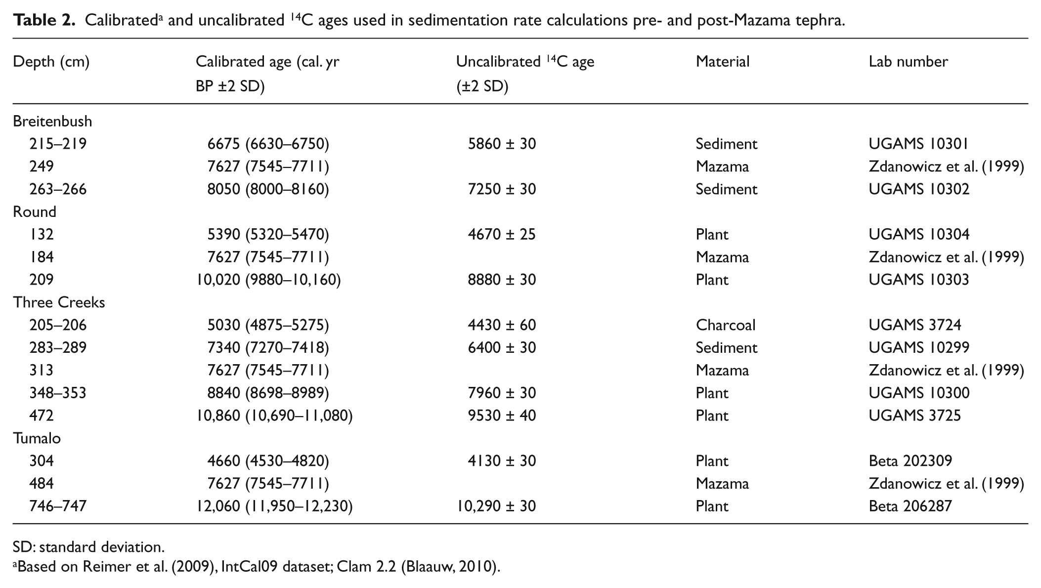
SD: standard deviation.
Based on Reimer et al. (2009), IntCal09 dataset; Clam 2.2 (Blaauw, 2010).
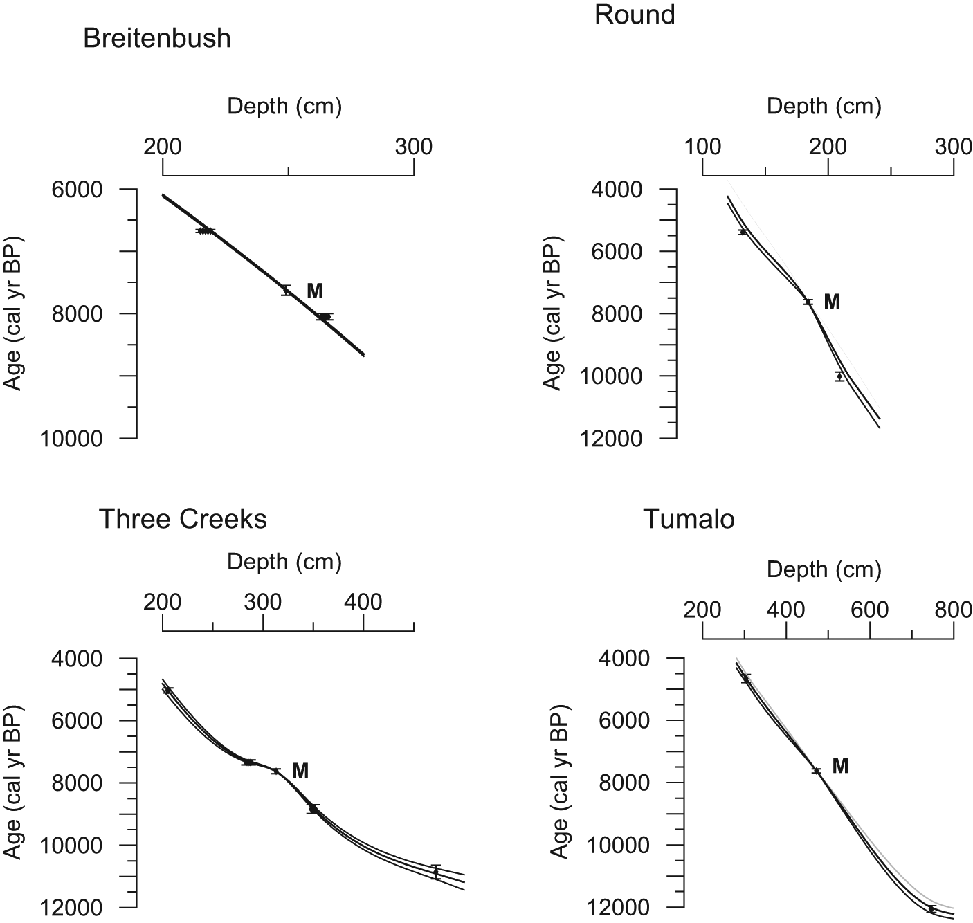
Age-versus-depth models for Breitenbush Lake, Round Lake, Three Creeks Lake, and Tumalo Lake for the sediment sections examined in this study with 95% CIs. Diamonds represent sample calibrated ages and bars indicate 2 SD error of each age. ‘M’ represents the Mazama tephra location.
Results
Lithology
Sediment core records recovered were 4.36 m from Breitenbush Lake, 2.98 m from Round Lake, and 5.31 m from Three Creeks Lake. Sediment at all three sites was similar to the Tumalo Lake record, which was 7.48 m in length. The new sediment records had dark brown (10Y 3/5) gyttja for the upper portion, grading to very dark grayish brown (2.5Y 3/2) gyttja for the lower portions, and gray or reddish clays at the base. The sections examined for this study did not have laminations. Mazama tephra was recovered at depths of 2.49–2.66 m (17 cm) at Breitenbush, 1.86–2.00 m (14 cm) at Round Lake, and 3.13–3.50 m (37 cm) at Three Creeks Lake. Mazama tephra occurred at 4.84–5.34 m (50 cm) in the Tumalo Lake core (Long et al., 2011). The Mazama tephra deposition was distinct with negligible mixing of tephra and sediment above or below the tephra deposit in each sediment record.
Chronology
The age–depth model for Breitenbush Lake indicated a basal date of 15,470 cal. yr BP and a sedimentation rate that varied from 28 to 45 yr/cm. The pre- and post-Mazama period examined here is from 2.40 to 2.59 m depth, corresponding to 7320 (CI: 7310–7340) and 7940 (CI: 7930–7960) cal. yr BP, with a sedimentation rate that ranged from 33 to 42 yr/cm (Figure 2). The age–depth model for Round Lake indicated a basal date of 14,060 cal. yr BP and sedimentation rates that varied from 20 to 80 yr/cm. The pre- and post-Mazama period examined here is from 1.79 to 1.88 m in depth, corresponding to 7220 (CI: 7130–7300) and 7900 (CI: 7730–7790) cal. yr BP, with a sedimentation rate that ranged from 60 to 70 yr/cm. The age–depth model for Three Creeks Lake shows a base date of 11,490 cal. yr BP and sedimentation rates that varied from 10 to 40 yr/cm. The pre- and post-Mazama section examined in this study was from a depth of 3.01 to 3.22 m, corresponding to 7460 (CI: 7440–7480) to 7860 (CI: 7840–7880) cal. yr BP, with a sedimentation rate that ranged from 10 to 30 yr/cm. The terminal date for analysis of the Tumalo Lake record was 12,100 cal. yr BP with sedimentation rates that varied from 10 to 20 yr/cm. This study examined from 4.61 to 4.91 m depth, corresponding with 7430 (CI: 7410–7450) to 7980 (CI: 7950–8000) cal. yr BP and an average sedimentation rate of 20 yr/cm.
Pollen
Pollen records from each site indicate that there was no change in taxa from pre- to post-Mazama deposition (Figure 3). Pinus was the dominant pollen taxon at all sites. Other common AP was Abies, Picea, and Cupressaceae with minor contributions from Pseudotsuga menziesii, T. mertensiana, and Tsuga heterophylla. Nonarboreal taxa were dominated by riparian species such as Alnus and Betula at Breitenbush Lake, Round Lake, and Tumalo Lake, while Artemisia was the dominant nonarboreal taxon at Three Creeks Lake. Comparison of the pre- and post-Mazama pollen percentages from sediment immediately before and after the Mazama tephra deposition showed that arboreal percentages increased at Breitenbush Lake, Three Creeks Lake, and Tumalo Lake in the post-Mazama sample. At Round Lake, arboreal percentages displayed a decrease in the post-Mazama sample. The AP/NAP ratios indicate a similar response to that of the percentage data (Figure 4). A shift to higher AP/NAP values at Breitenbush Lake, Three Creeks Lake, and Tumalo Lake in the immediate post-Mazama sample suggests that nonarboreal species pollen production declined after the Mazama deposition at these sites. At Round Lake, the AP/NAP ratio of the post-Mazama sample declined, indicating an increase in the NAP immediately after the Mazama deposition. The high post-AP/NAP values were short lived at Breitenbush Lake, Three Creeks Lake, and Tumalo Lake as values returned to pre-Mazama AP/NAP ratio values within three samples (50–100 years). At Round Lake, the post-Mazama AP/NAP ratios remained similar to the pre-Mazama values. The AP/NAP ratio declined at Round Lake, Three Creeks Lake, and Tumalo Lake after Mazama deposition.
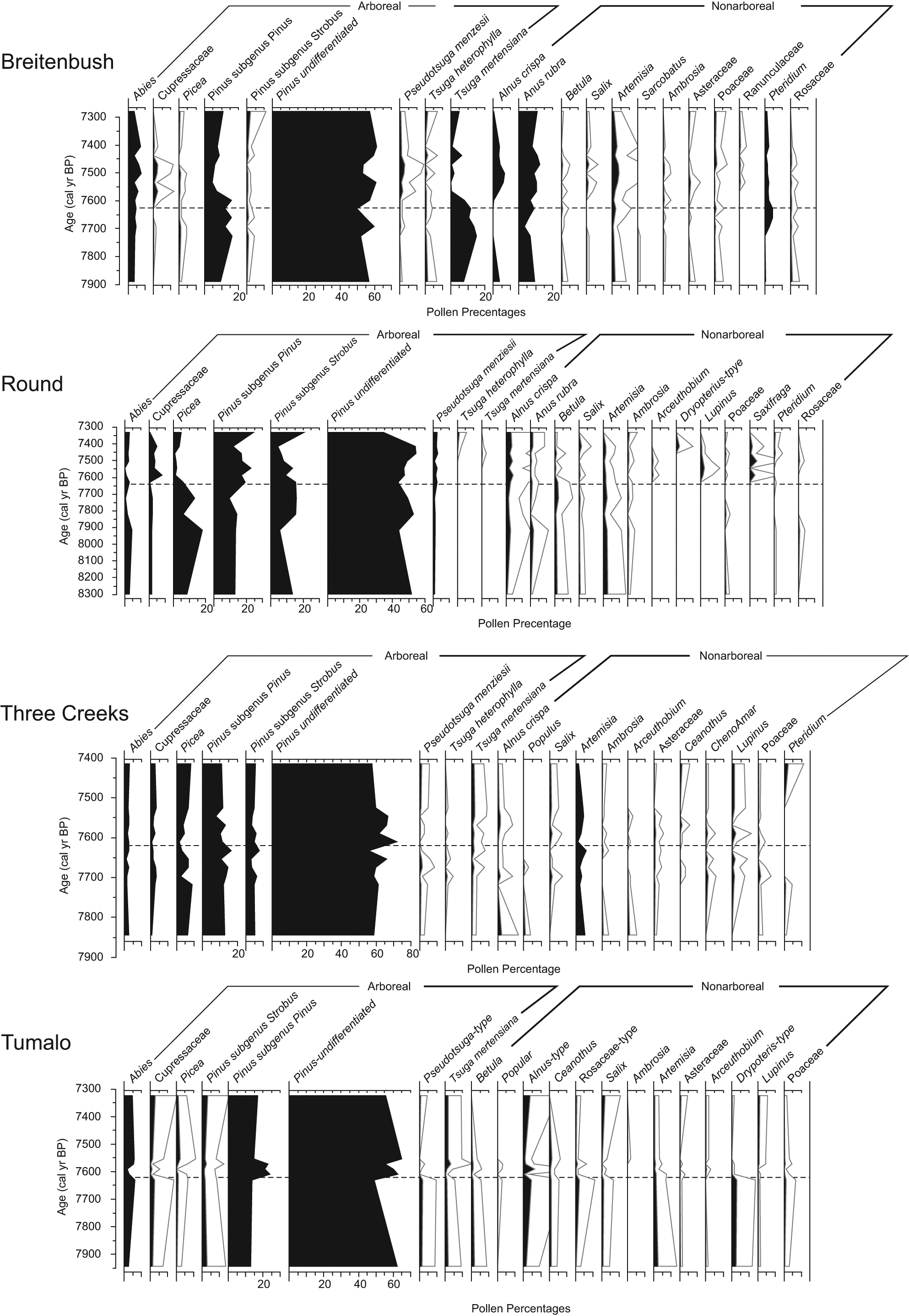
Pollen percentage data from Breitenbush Lake, Round Lake, Three Creeks Lake, and Tumalo Lake for the lake core section examined in this study plotted against age. Outlines represent a 5× exaggeration of percentage values. The horizontal line indicates the location of Mazama tephra. Taxa are grouped as arboreal or nonarboreal.
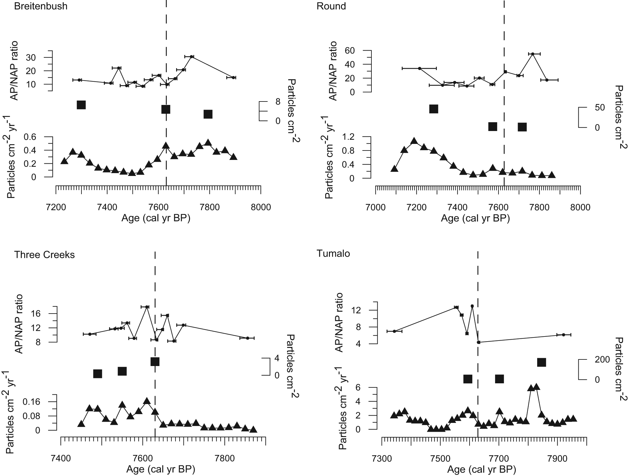
Charcoal accumulation rates (CHAR; triangles), fire episodes (squares), and arboreal pollen (AP) and nonarboreal pollen (NAP) ratios (circles) for Breitenbush Lake, Round Lake, Three Creeks Lake, and Tumalo Lake plotted against age. The vertical dashed line represents the location of Mazama tephra in each lake core. The CHAR data are plotted at evenly space time intervals (see ‘Methods’ section). The fire episodes are plotted with magnitude of charcoal concentration represented in each peak (particles/cm2). The AP/NAP ratios include the 95% CIs of age represented by each pollen sample. Higher AP/NAP ratios indicate an increase in AP while lower ratios indicate an increase in NAP.
Charcoal record
The range of background CHAR varied between sites with Three Creeks Lake having the lowest CHAR range (0.01–0.05 particles/cm2/yr) and Tumalo Lake having the highest (1.03–1.75 particles/cm2/yr). All sites showed increases in CHAR that were identified as peaks prior to and after Mazama deposition (Figure 4). Breitenbush CHAR peaks occurred at 7300, 7630, and 7790 cal. yr BP. Round CHAR peaks occurred at 7280, 7570, and 7720 cal. yr BP. Three Creeks CHAR peaks occurred at 7470, 7530, and 7630 cal. yr BP, and Tumalo CHAR peaks occurred at 7590, 7700, and 7850 cal. yr BP. Breitenbush and Three Creeks had a CHAR peak in the 1-cm sediment section adjacent to (after) the Mazama tephra. Round Lake and Tumalo Lake had a CHAR peak in the sediment section 2 cm after the Mazama tephra deposit (Figure 4).
Discussion
The immediate impact of tephra on forest vegetation varies from plant mortality, to burial, to inconsequential, as a result of a dusting of tephra. In the PNW, the eruption of Mt St Helens in
The reconstructed fire histories indicate that fire events are a common disturbance at each site (Figure 4). At Breitenbush Lake and Three Creeks Lake, fire events may have been precipitated by the Mazama deposition. Fire events at these sites occurred in the stratigraphic sample immediately after Mazama tephra (i.e. the 1-cm sample adjacent to the Mazama tephra) and may have been precipitated by an increase in fuels from Mazama-tephra-induced plant mortality or stress. Because of the delay after tephra fall, we suspect that the fire events at Round Lake and Tumalo Lake were the result of typical fire weather conditions and likely not related to increased fuels as a result of vegetation mortality. The peak in CHAR at Round Lake occurred 40–60 years after the tephra fall (i.e. after the deposition of 2 cm of sediment). At Tumalo Lake, the peak in CHAR occurred 20–40 years after the tephra fall. That fire events were associated with Mazama tephra deposition with only two of the four sites suggests that (1) the impact of Mazama tephra deposition on plant mortality was not sufficient to systematically create fuel conditions that precipitate fire events or (2) seasonal fire weather was a more critical factor in generating fire events than disturbances such as moderate tephra deposition seen in these watersheds. We suspect that the Mazama tephra fall may have simply been coincident with the regional fire season (Hallett et al., 1997).
The results presented here suggest that the additive effects of disturbances are stochastic across the landscape or are synergistic between specific types of disturbance. The tephra fall examined here was associated with a decrease in NAP, presumably through mortality of the nonarboreal vegetation. However, fire events in these forests are the result of burning arboreal vegetation and since arboreal vegetation was little affected by the tephra fall, there was only partial temporal correlation with the tephra deposition. It seems likely that the cumulative effect of disturbances only applies to disturbances that affect the same components of the ecosystem. Based on evidence presented here, moderate tephra deposition by the Mazama eruption did not alter forest vegetation or soil composition enough to affect the post-tephra fall growth of the arboreal plants that play the major role in fire events. In contrast, there may be a connection between the mortality of arboreal vegetation by insects and fires in areas where insect outbreaks have occurred (Romme et al., 2006). Our findings suggest that tephra fall in moderate amounts does not cause enough forest vegetation mortality to change forest composition or precipitate fires on a regular basis. Clearly, fires were associated with the Mazama tephra deposit at Breitenbush Lake and Three Creeks Lake. However, fires did not occur at the other sites, suggesting that the Breitenbush and Three Creeks fires may have been a stochastic response to typical fire occurrence controls, such as low fuel moisture and lightning, and not part of a consistent pattern of synergistic relations between fire and Mazama tephra deposition.
Footnotes
Acknowledgements
We thank PJ Bartlein for providing the initial questions that this paper addresses. CJL designed the project; CJL, TAM and ALH performed the field work; and all authors collected and analyzed the data, and wrote the manuscript.
Funding
This project was supported by the UW Oshkosh Faculty Development Program (FDR 641) to CJL, and a UW Oshkosh Student-Faculty Collaborative Research grant to ALH.