
Abstract
Intensifying water management for rice farming and related land use involves increasing labour investment in transforming local landscapes. By applying geoarchaeological investigation at the well-preserved late-Neolithic rice paddy site of Maoshan, Lower Yangtze River, during the excavation, this study provides detailed information of the changing relationship between water management, agricultural intensification, environmental change and social evolution during the critical time period of the late Holocene. It illustrates that the intensification of rice farming was facilitated by successful water management and landscape management in most time, and it was the combined effect of gradually increasing aridity, fluctuating sea-level patterns and increasing labour investment in water management that led to the eventual abandonment of the paddy field at the end of the Neolithic in this region. This study therefore draws attention from large-scale sites to small-scale, but economically important, sites in enhancing our understanding of the dynamic relationship between human societies and environmental changes during the late Holocene in this region.
Keywords
Introduction
Liangzhu (5300–4200 cal. yr BP), the late-Neolithic culture, in the Lower Yangtze River, created one of the most fascinating cultures in Chinese prehistory. A large number of jade artefacts with intriguing patterns and amazing quality were produced (Forsyth, 1995; Qin, 2013; Rawson, 1995; Wang, 1998a, 1998b), extravagant mortuary practice was developed (Liu and Chen, 2012: Chapter 7; Qin, 2013) and, more importantly, a well-structured site, the Liangzhu site, was constructed, surrounded by many contemporary satellite settlements (Zhejiang Provincial Institute of Cultural Relics and Archaeology, 1999). Parallel with these are the massive investment in water management and gradually intensifying rice agriculture.
In the Lower Yangtze River, rice was consumed at the beginning of the Holocene (Liu et al., 2007). The domestication of rice, however, was a prolonged process (Fuller et al., 2007, 2009). It occurred in this region between 6900 and 6600 cal. yr ago as evidenced by the increasing proportion of nonshattering domesticated rice (Oryza sativa) spikelet bases in archaeobotanical assemblages (Fuller et al., 2009), along with the establishment of early farming fields as supported by the presence of arable weeds in these assemblages (Fuller et al., 2009) and related phytolith analysis (Zheng et al., 2009). However, the palaeo-diet was still largely dependent on the consumption of wild gathered and hunted foods (Qin et al., 2010). It was probably not until the late-Holocene Liangzhu Period that we see rice farming became overridingly important in economic subsistence.
While systematic studies on stone tools potentially used for farming continue to provide new insights into our understanding on technological innovations in relation to agricultural development in this region through time (ongoing research by L Qin and S Nakamura), the excavation at a well-preserved rice paddy field site of Maoshan offers an excellent opportunity to assess the scale, practice and evolution of water management and rice farming of the Liangzhu Culture. This paper presents important discoveries of the excavation and results of the geoarchaeological investigation at Maoshan. The geoarchaeology, which combines environmental studies with archaeology, enables a closer examination of palaeo-hydrological and in-field ecological changes at Maoshan. Particularly, the high-resolution micromorphological information of cultivated soils and the underlying and overlying horizons at Maoshan reveals that the intensification of rice cultivation in the late-Liangzhu Period was facilitated by successful water management in most times. In addition, there is also clear micromorphological evidence of land-use management, such as the use of fire, land clearance and manuring. This research thus also promotes the integration of different lines of palaeo-environmental evidence with variable scales on the relationship of palaeo-environmental change, development of rice farming and evolution of the Liangzhu Culture in this area.
Environmental backgrounds and geological settings
Holocene sea-level change and Asian summer monsoon are the two main factors which have exerted fundamental impacts in modifying local ecological conditions in the studied area, covering Hangzhou Bay, the Yangtze River Delta and Taihu Lake to the north (Figure 1a). The summer monsoon brings large amounts of rainwater between mid-May to late-June (Chen et al., 2004; Wang and LinHo, 2002), during which time lowland areas are prone to flooding. This annual variation of water regime has great influence on rice growing and harvesting, which usually takes place in spring and summer.

Geographic location of the rice paddy field: (a) Google map of the research area, showing the site, the Taihu Lake and the Hangzhou Bay and (b) location of the Maoshan site, between the Maoshan Hill and the alluvial plain. (b courtesy of Dr L Qin).
In the early Holocene, a quick sea-level rise (reaching −5 m relative to the present sea level) is witnessed, resulting in an accelerated sedimentation rate in low relief areas such as the Yangtze River Delta (Hori et al., 2002; Stanley and Chen, 1996; Zong et al., 2012). This transformed the regional landscape from an ‘open, brackish water environment’ to a ‘largely enclosed, wetland system’ and/or freshwater marsh environments (Zong et al., 2012). It then experienced continued sea-level rise (reaching −2.5 m at 7000 BP and then at an average of c. 0.36 mm/yr from 7000 BP onwards; Zong et al., 2012) during the middle Holocene, roughly between c. 7000 and c. 4200 cal. yr BP (Wang et al., 2001), but more and more evidence also suggests that instead of experiencing steady sea-level rise, the mid-Holocene sea-level highstand underwent a rather undulating trend. Decadal and interannual variability was taking place (Atahan et al., 2008; Douglas et al., 2000; Xin and Xie, 2006). However, this mid-Holocene sea-level highstand had fundamental consequences in local environments, mainly represented by the evolution of delta plains and coastal wetlands and by the resultant rising groundwater level and poor drainage (Stanley and Chen, 1996; Zong et al., 2012). Sea level continued to rise slowly in the late Holocene from c. −2.5 m to about the present level by c. 3000 cal. yr BP, during which time small estuaries and tidal flats evolved to freshwater marsh environments (Zong et al., 2012). Two cooling events occurring in around c. 5500 cal. yr BP and between c. 4300 and c. 4000 cal. yr BP are also reported (Chen et al., 2005; Tao et al., 2006; Wang et al., 2005; Zong et al., 2012), but details and mechanisms remain unclear.
The Hang-Jia-Hu Plain, where most Liangzhu Culture sites are located, is surrounded by the Tianmu Mountains to the west, the outliers of the Tianmu Mountains and the Dazheshan Mountains to the north, and the Daxiong and Daguan mountainous areas to the south. Within the plain, there are many small hills 20–50 m high. Maoshan is one of them, extending east-westerly for about 200 m, and 50 m in altitude. The plain is crisscrossed by a developed water system, consisting of many rivers, ponds and swamps (Shi et al., 2011). The geology of the mountains is dominated by different igneous and metamorphic rocks derived from active volcanic and tectonic (geological fracture) activities particularly during the Cretaceous (Wang et al., 2006). According to geological surveys, the geology of Maoshan is, however, mainly composed of sedimentary rocks, including sandy mudstone, dolomite, limestone, silicalite and so forth. The plain primarily consists of alluvial, fluvial and colluvial deposits accumulated since the Pleistocene (Institute of Engineering and Hydrological Geology, Seismological Bureau of China, 1979). This is manifested by the multifaceted Holocene sequences in this region, characterized by a typical transgressive relationship between sediments of different facies, such as eluvial, colluvial and alluvial deposits derived from terrestrial sedimentation processes and estuarine and lagoonal deposits derived from marine processes (Liu and Dong, 1990; Shi et al., 2011).
Excavation at the Maoshan site
The Maoshan site (Figure 1a and b) is located about 20 km to the east of the Liangzhu Culture walled site. Consecutive excavations have revealed well-structured paddy fields belonging to the mid- and late-Liangzhu Culture, sitting on an intermediate zone between the flat alluvial plain and the low hillslope of the Maoshan Hill (Figure 1b), and contemporary settlements located on the slope areas.
Before the construction of the Liangzhu paddy fields, three house foundations, four graves, some 160 pits and two wells belonging to the Majiabang Period (c. 7000–6000 cal. yr BP) were built.
The excavated Liangzhu-Period archaeological features include two house foundations, some 80 pits and 161 graves, as well as other features such as wells, road tracks and so forth. The mid-Liangzhu field is divided by a natural creek in the middle, roughly northwest-southeasterly oriented. The field was initially dug into alluvial materials and segregated into a few small squares which were connected to the creek by small ditched outlets (Figure 2a). A total of 26 squares have been unearthed, of variable plans and ranging in size from 1–2 m2 to 30–40 m2. Between the squares are higher alluvial sediments, covered by thin layers of fine sandy and clayey materials and pottery shards. In the eastern end of the natural creek, a well-preserved canoe (7.35 m × 0.45 m × 0.23 m) was found, made of rounded-shaped Chinese red pine (Figure 2b). Besides those in the sedentary area, two wells were also dug in the field, likely used in irrigation.
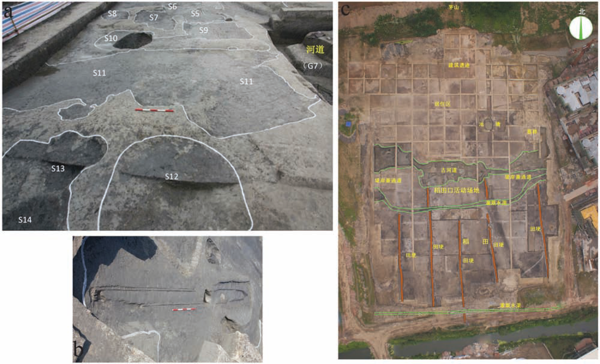
Excavation at Maoshan: (a) earlier period (mid-Liangzhu) paddy field, ‘S’ denotes the numbers of separate squares; (b) later period (late-Liangzhu) paddy field, red lines are small pathways across the field and green lines are the sketches of ditches. More legends are explained in Figure 3d; and (c) well-preserved (mid-Liangzhu) canoe.
The field was then overlain by light-yellowish alluvial materials, upon which the late-Liangzhu paddy field was built (Figure 2c). This period witnessed fundamental changes in the construction and use of the field. An artificial creek was newly dug between the field and the sedentary area for the purpose of water management, along with many other small ditches located further south. Coring survey finds that this creek was parallel with the natural creek in use in previous period, but extending for a longer distance in the east–west direction. Between these ditches, narrow paths made of burnt earth were constructed across the field in a north-southerly direction, which divided the field into much larger squares compared with previously. They are normally 1000 m2 in size, but some can be up to 2000 m2. The size of the entire field is about 5.5 hectares (700 m × 45–100 m), according to the excavation and survey.
After abandonment, the late-Liangzhu paddy field was covered by a layer of organic-rich and humified peat-like sediment, containing Guangfulin-Period pottery (dated to the end Neolithic, c. 4100–3800 BP), on top of which a line of cow footprints is preserved. The sequence is finished with the deposition of a homogeneous layer of silty clay up to 1 m thick, marking the end of rice cultivation.
Materials and methods
Soil samples were collected from on-site and off-site contexts (Figure 3), which cover paddy fields, fills of ditches and natural alluvial sequences. These alluvial sequences are located in places c. 300 m, 500 m, and 2 km away from the archaeological site, respectively (Figure 3b). In addition, modern cultivated soil samples were collected from paddy fields around the site for comparison. A total of 42 particle size analyses were conducted at the Department of Geography of University of Cambridge using Malvern Mastersizer 2000 following the standard procedure described at http://www.geog.cam.ac.uk/facilities/laboratories/techniques/psd.html. A total of 77 thin sections were made following the method described by Murphy (1986) and Courty et al. (1989) and were observed by petrological microscope (plane-polarized light (PPL) and cross-polarized light (XPL)) with the help of oblique incident light (OIL) and fluorescence microscope following the terminologies provided by Bullock et al. (1985) and Stoops (2003). A total of 29 AMS 14C dates were obtained at the School of Archaeology and Museology of Peking University. These dates were calibrated by using the IntCal04 calibration curve and the OxCal v3.10 software. Most of the dates for the paddy field deposits fall into the time span of 4700–4200 cal. yr BP, that is, the mid- to late-Liangzhu Culture Period, but full AMS 14C reports will be published separately.
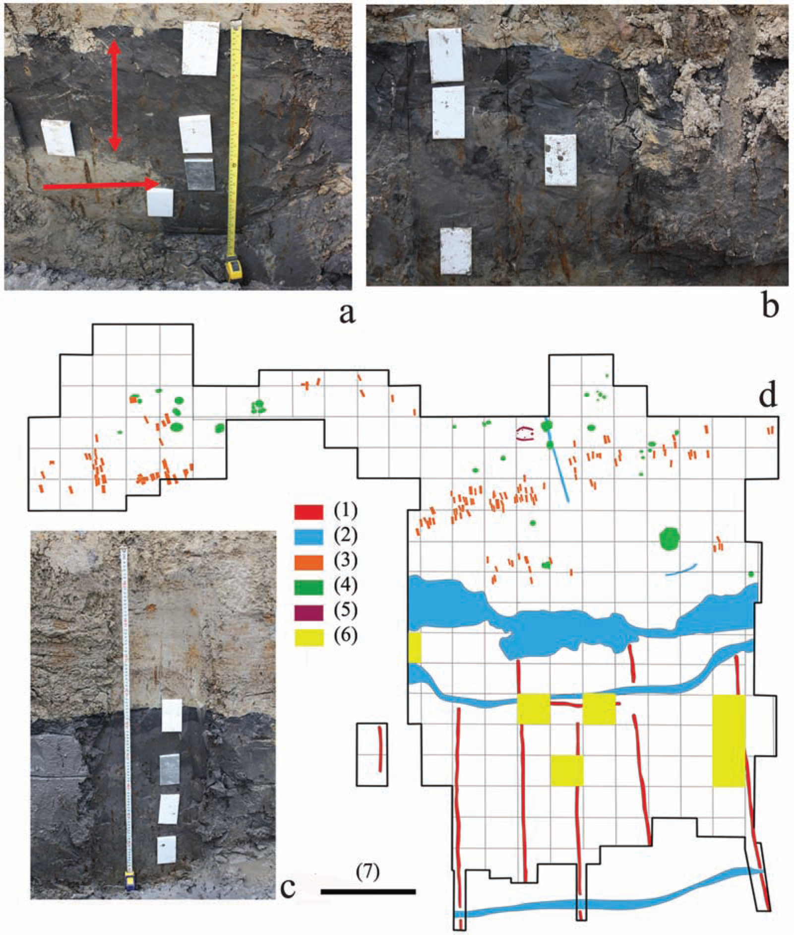
Stratigraphies and sampling plans: (a) Profile 4 showing the greyish–darkish later period paddy field deposits (two-head arrow) and earlier period paddy field deposits (red arrow); metal boxes show sampling locations for micromorphology, same blow; (b) profile examined at the park to the east of the Maoshan site, in roughly same stratigraphic order as those examined in the field, the greyish–darkish alluvial materials overlie on top of pale-yellowish alluvial materials and covered by light-yellowish flooding deposits; (c) Profile 2 showing the peat-like deposits and the underlying greyish–darkish later period paddy field deposits; and (d) excavation outline and sampling plans. (1) small pathways across the paddy field, (2) later period ditches, (3) burials, (4) pits, (5) houses, (6) sampling locations, in addition to these, locations for off-site samples and modern rice paddy soils are not showed here and (7) bar length = 30 m.
Results
Results of particle size distribution are shown in Figure 4. Results of the micromorphological examination of the mid- to late-Liangzhu paddy fields are summarized below. More detail is given in Table 1 and Supplementary Table (available online). Together with excavation, micromorphology provides unambiguous evidence of rice farming, water management and the expansion of rice agriculture through time.
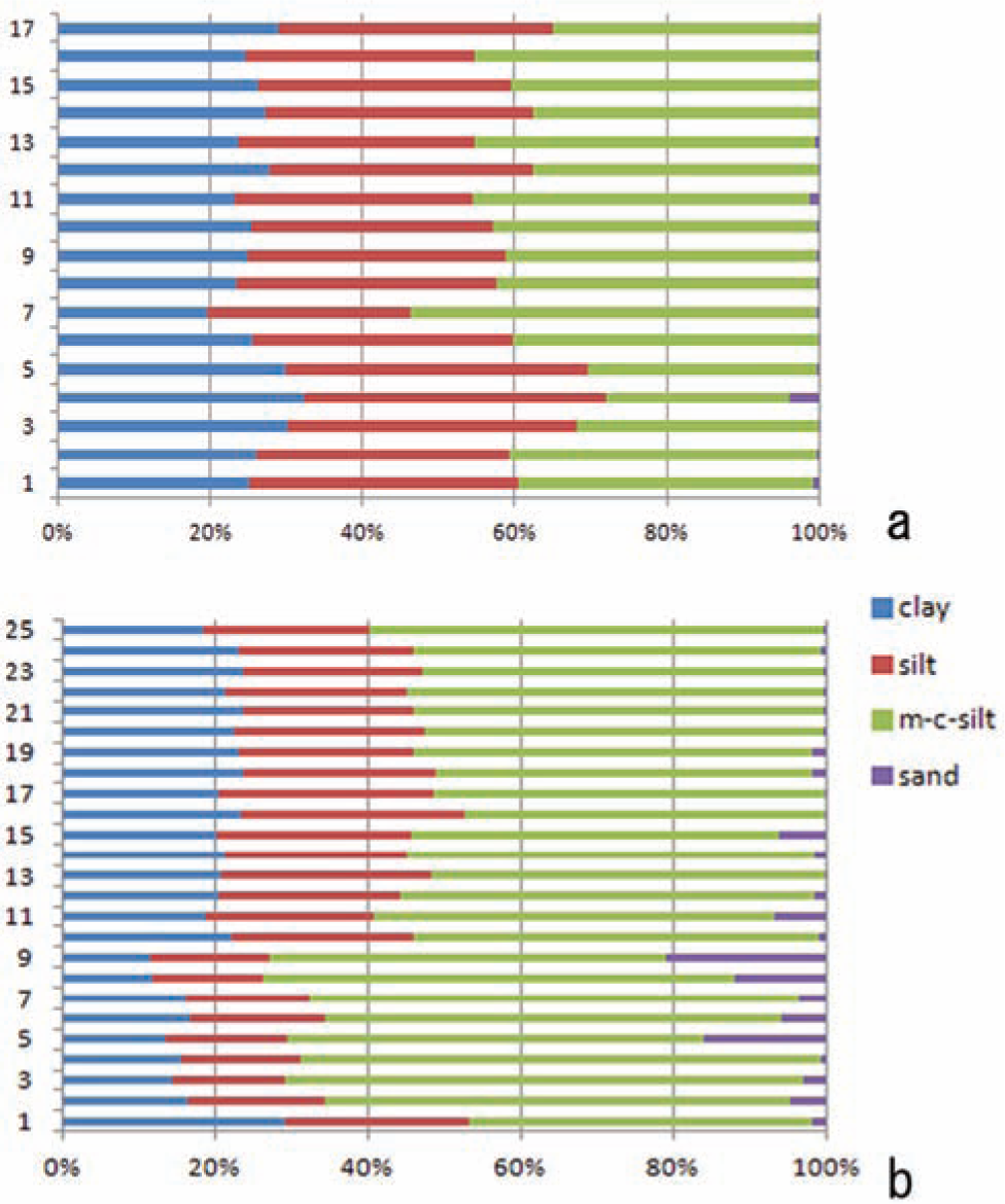
Results of particle size distribution: (a) particle size distributions of 17 samples collected from a off-site sequence (section 1, MSP1); 17–1, bottom to top; and (b) particle size distributions of 25 samples collected from section 2 (MSP2) from the paddy field, 25–1, bottom to top.
Results of the micromorphological examination of the mid- to late-Liangzhu paddy fields.

Vcsz: very-coarse-sand-sized; fsz: fine-sand-sized; msz: medium-sand-sized; csz: coarse-sand-sized; vfsz: very-fine-sand-sized; vf: very fine; op: organic pigment; OP: organic pigment; OM: organic matter; CC: clay coating; HC: hypocoating; QC: quasi-coating; FN: Fe nodules; CCF: clay concentration feature; HA: heterogeneous aggregates; ++: 10–20%; +: 5–10%; **: 5–2%; *: <2%.
Might be mistaken with MS-S12, but MS-S12 belongs to the earlier period paddy field nonetheless.
Water management and hydrological changes through time
Water management for rice cultivation during the mid-Liangzhu Period at Maoshan was mainly reliant on the maintenance of the natural creeks across the field. A small amount of labour was invested in building ditch outlets to connect the field with the creeks for draining and watering (Figures 2a and 3a). This had caused some change in soil paedogenetic processes, among which the Fe oxide coatings and hypocoatings are most abundantly present (Figure 5c). They are mostly formed along very large plant root channels, suggesting that oxidation was taking place here when the soil was saturated, leaving the voids an aerobic environment for oxidation (Lindbo et al., 2010). Such features, however, also appear in natural/undisturbed soils as rhizomes of grassy plants often derived such features under natural wet–dry alternating conditions (Vepraskas, 2001). The more diagnostic features are those clay textural features, primarily including the so-called clay concentration features and/or dusty or silty clay features, which according to some recent research (Lee, 2011) are associated with textural changes of the groundmass because of irrigation or water management under cultivation. These features are indeed characterized by their great contents of coarse particles (silt-sized), diffuse boundaries with the soil groundmass and weak or no birefringence under XPL (Figure 7b). However, while the similarity in the textual features found in our study and those recognized by Lee (2011) from modern and ancient cultivated soils in South Korea does suggest that they would have resulted from water management or related activities, cautions should be applied when making such an interpretation as such textual features can be formed as long as there are suitable conditions, including broken down soil particles, physical mobility of particles because of quick water saturation and quick precipitation with poor sorting (Lindbo et al., 2010).
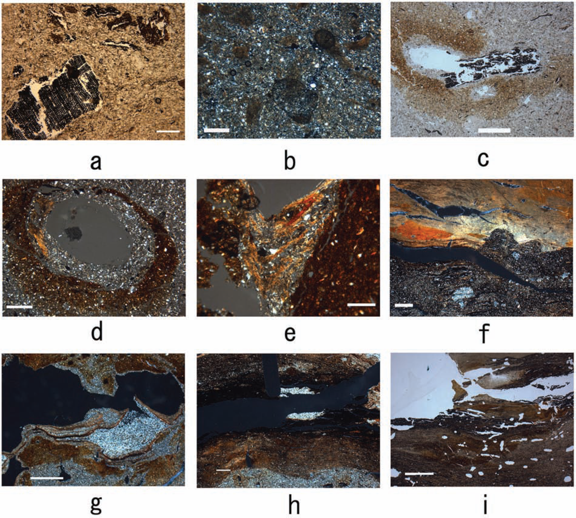
Micromorphological images from Maoshan: (a) later period charcoal and organic aggregates (MSP10:1), 400 µm (scale bar length, same below), PPL (plane-polarized light, same below); (b) later period dusty clay concentration features as a result of irrigation (MSP10:2), 50 µm, XPL (cross-polarized light, same below); (c) early-period charcoal in a void and Fe oxide feature (MSP10:3); 2.5 mm, PPL; (d and e) later period Fe oxide features and concentric dusty clay features (MSP7:2) resulting from chemical reactions and physical movement of clay particles, respectively, because of multi-episodes of wet–dry alternations, note iron-depletion and enriching areas in (d), 500 and 200 µm respectively, XPL; (f) the transition from later period paddy field to weak peat growth (MSP6:1), note the presence of very-coarse-sand-sized quartz, 500 µm, XPL; (g) later period Fe oxide feature and multi-period dusty clay features (MSP2:3), 2 mm, XPL; (h) the transition from later period paddy field to peat growth (MSP2:1), note the brownish clayey layer sandwiched between the organic-rich peaty layer and the silty layer, 2.5 mm, XPL; and (i) the transition from the alluvial sediment to peat growth (off-site sample), note the vesicle voids with smooth walls, 1.5 mm, PPL.
In addition to these are the abundant crusts, which are less-commonly encountered in thin sections from the late-Liangzhu paddy field. These crusts are composed of dusty to silty clay, with clear tendency of sorting (Figure 7c). They are formed during short periods of surface drying (Pagliai and Stoops, 2010) in an otherwise prolonged waterlogged condition. The crusts are generally densely overlapped layer by layer, partly because the surface drying was taking place frequently, but might be also because of compaction after burial. It is also interesting to note that some of them have a serrated surface, probably resulting from bioturbation when the surface was dry.
The transition from the earlier rice field to the later one was accompanied with fundamental changes in water management. First, a few more artificial ditches were newly dug; between these are the paddy squares much larger in size (see above and Figure 2c). Second, and more importantly, redoximorphic features, especially the typical concentric features formed by repeated Fe depletion and re-precipitation are especially abundant (Figures 5d and e and 6g and h), indicative of much longer periods of water saturation (Lindbo et al., 2010; Richards and Vepraskas, 2001). These were nonetheless frequently punctuated by short-term drying periods because of deliberate draining for rice farming. Associated with these are the Fe-depleted areas in the groundmass. The more commonly present dusty or silty clay textural features, including both clay concentration features and coatings (Figure 5b), further suggest frequent wet–dry alternations resulting in chemical reactions and physical movements of particles within the soils, implying a much more controlled water regime under management.
Scanned and micromorphological images from Maoshan: (a) scanned image of MSP2:1, image size 4.5 × 8.5 cm; (b) scanned image of MSP7:2, note the disturbed soil structure, 5 × 8 cm; (c) scanned image of MSP1:2 (off-site sample), note the homogeneous and less-disturbed soil structure, 4 × 7.5 cm; (d) later period anthropogenic inclusions (MSP10:1), dung fragment, 500 µm, PPL; (e) horizontally distributed thin lenses of organic materials (MSP2:1), 1.6 mm, PPL; (f) later period anthropogenic inclusions (MSP7:2), 500 µm, PPL; (g) early-period Fe oxide and dusty clay features (MSP2:4), 2 mm, XPL; (h) later period Fe oxide features, note the alternation of iron-rich and depletion areas (MSP5:2), 100 µm, XPL; (i) later period charcoal in void and Fe oxide feature (MSP7:3), 200 µm, XPL; (j) early-period charcoal with well-preserved plant tissue structure (MSP10:3), 250 µm, PPL and (k) early-period anthropogenic inclusions (MSP10:3), 2 mm, PPL.
Dramatic hydrological change was recorded towards the end of the late-Liangzhu paddy field. In the upper part of the late-Liangzhu cultivated soil immediately underlying the peat-like sediments (Figure 6a), horizontally distributed thin lenses of organic matter are interbedded with a silty to clayey soil groundmass (Figure 6e). These organic lenses probably formed during a controlled flooding season or irrigation. Their poor preservation suggests episodic wet–dry events, which encouraged organic decomposition. Further up in the profile (Figure 3a and c), in the transitional zone to the peat layer, organic-rich sediment is replaced by poorly sorted orange silty clay, which might be a sign of periodic flooding (Figure 5h). The presence of slightly laminated clay lenses within this horizon also indicates low water velocity. Then, there was the onset of peat accumulation alternating with silty clay fraction and very few micritic quartz and other minerals (Figure 5f and h). This suggests, on the one hand, that flooding events were continuing, but for most of the year, the groundwater was already high enough to facilitate the encroachment of wetland reed fen onto the already abandoned paddy field. This quickly gave way to a sedimentation regime dominated by peat growth. However, the accumulating organic matter was often disturbed and broken up as a result of seasonal surface degradation. This suggests seasonal drying and disturbance. Between the transitional zone of peat growth and the overlying clayey flood sediment, there was a return to interspersed horizons of peaty and silty mud fractions. This episodic peat development occurred under fluctuating water-table conditions.
Albeit providing insightful information concerning water management and rice farming, the above reflects a more localized picture of the relationship between rice farming and environmental change. This should be supplemented by the examination on samples collected from wider environmental contexts. The off-site peat sediment (Figure 3b) is more homogeneous than its counterpart in the paddy fields, implying less disturbance during peat growing (Figures 5i and 6c) and probably a more stable groundwater regime. Immediately on top of the alluvial materials which are the parent materials of the cultivated soils in the paddy fields, the sequence is dominated by alternating peat and micritic minerals. The organic matter is more homogeneous, mostly with horizontal distribution except for occasional bioturbation that generates some bow-like microstructures. Of particular interest are the distinct vesicle voids found here (Figures 5i and 7d), suggesting fast aeration after saturation.

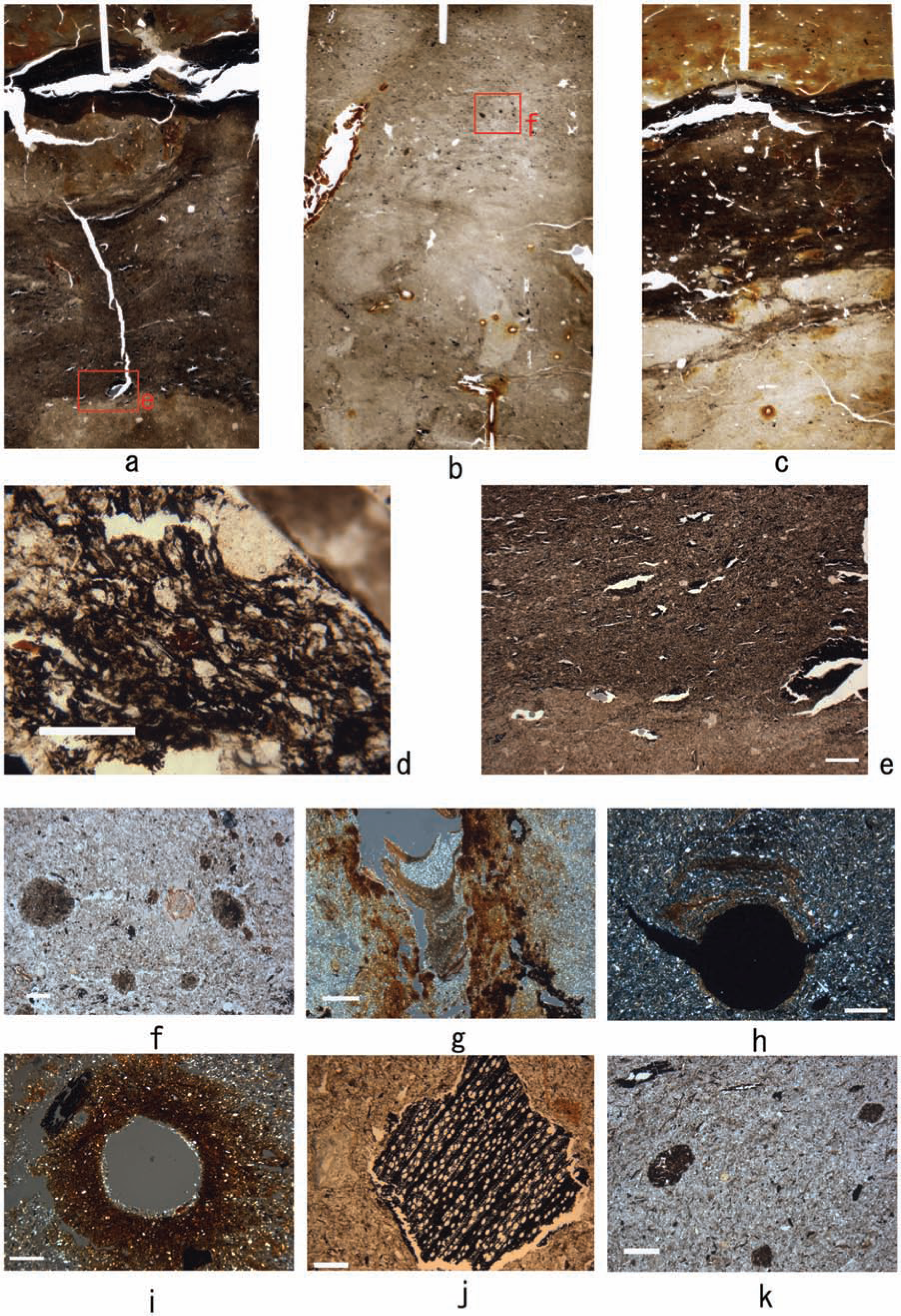
Scanned and micromorphological images from Maoshan: (a) scanned image of MSP10-1, showing later period ploughing and cutting marks, note the whitish aggregates been churned up from the lower layer; image length 5.5 × 8 cm; (b) earlier period clay concentration features (MS-S19), note the darkish colour and diffuse boundary with the groundmass, 500 µm, PPL; (c) earlier period crust features (MS-S10), note the voids within these crusts, 850 µm, PPL; (d) vesicle voids, MSP1:2, 1 mm, XPL; (e) off-field charcoal (MS-Park), note the dust clay coatings around the void, 500 µm, PPL; and (f) locations of Maoshan and other contemporary Liangzhu-Period sites, including cemeteries and settlements. Although the functions of particularly the settlement sites are not well understood, it can be seen from the map that most of the sites are indeed situated very close to small mountains in this area. (f courtesy of Dr L Qin).
Both the paddy field and its surroundings were covered by clayey flooding deposits up to 1 m in depth. It should also be noted that we are not able to know how the local environmental change observed here is related to the regional alluvial activities induced by sea-level and climatic (monsoonal) changes, which is a topic subject to systematic surveys in the future.
Development of farming practices
Systematic studies have revealed a clear developmental discourse of different type of stone agricultural tools throughout the Liangzhu Period. The Liangzhu agricultural tools include potuqi (tools for breaking up soils), yuntianqi (tools for cutting the whole rice plants as shown by experimental studies) and sickles (ongoing research by L Qin and S Nakamura). The former two are likely bound to wooden instruments. The excavation and geoarchaeology at Maoshan provide direct evidence for their use in rice farming. Between the two periods of paddy fields and the deposits underlying them, tool marks creating clear-cut boundaries are often found (Figure 7a). The boundaries between the late-Liangzhu field and the underlying alluvial deposits are particularly sharp, implying a more intensive ploughing strategy. Moreover, the groundmass of the late-Liangzhu cultivated soils is full of disrupted soil aggregates consisting of heterogeneous materials (Figure 7a). These are probably products of severe churning and mixing of the soils during ploughing.
While there is already clue of manuring in the early-Neolithic rice farming in this area (Zong et al., 2007), our micromorphological examination offers straightforward evidence of deliberate addition of dung fragments, night soil and so on to the cultivated soils as soil amendment (Figure 6d, f and k). These are, again, significantly more abundant in the late-Liangzhu cultivated soils than in the earlier ones (also see the Supplementary Table, available online). The addition of soil amendment is also suggested by the results of particle size distribution. As can be seen in Figure 4, bulk samples from the late-Liangzhu field have a noticeable contribution from sandy particles, while their counterparts in off-site contexts contain very few or no particles larger than medium or coarse silt size. With the construction of the artificial ditch in the north of the field which essentially stopped the deposition of eroded material from the nearby hill (Figures 2c and 3d), the presence of those coarse material can be best explained as deliberate addition to the soils.
These heterogeneous aggregates were probably burned before being added to the soils, as most of them have a dense, dark-brownish or reddish colour under both XPL and PPL (Figure 6f and k). Despite this, phytoliths, commonly present in dung fragments because of animals’ consumption and digestion of plants, are preserved in many aggregates.
Two harvesting methods may have been employed. The first one involves the use of aforementioned stone sickles. Rice plants were cut from the stem, or in some instances, only panicles were cut by sickles, leaving straw in the field (cf. Weisskopf, 2009: 372–374). The second one is revealed by micromorphological examination. The occasional presence of small hole-shaped microstructures in thin sections from the mid-Liangzhu paddy field was probably caused by uprooting whole rice plants while harvesting (cf. Fuller et al., 2007). Although the information currently available at Maoshan is not sufficient to support the argument that the application of sickle harvesting in rice farming may have significantly accelerated domestication process of rice (cf. Fuller et al., 2009), future research might reveal that the development of harvesting techniques throughout the Liangzhu Period may have indeed played a very important role in the evolution of rice farming in this area.
It appears that firing was widely applied in managing field ecology. Apart from the randomly distributed charcoal within the groundmass, charcoal derived from in situ burning is often found inside large root channels in both mid- and late-Liangzhu paddy fields (Figure 5c). This suggests in-field-ecological interference perhaps during the growing and after the harvesting seasons. Firing not only creates ideal material, ash, for improving soil nutrient, but it might also help in reducing the growth of weedy plants.
Discussion
Population growth, water management and intensifying rice cultivation
The development of the Liangzhu Culture was coincident with population expansion. The construction of the large walled site at Liangzhu and the associated facilities (e.g. artificial platforms used for elite burials and as an observatory) is an indication of highly stratified society and may have been both the trigger and consequence of population expansion (Liu, 2007). Especially engrossing is the construction of a huge dam in front of a canyon to the north of the walled site in the mid-Liangzhu Period. This may have served as an important barrier to prevent the site from being inundated by serious floods during the monsoonal rainfall season. The walled site was surrounded by both artificial and natural water. The completion of these labour-consuming edifices and the political system that supported them could not have achieved and survived without a surplus of rice. The late-Liangzhu Period (c. 4500–4000 BP) witnessed a large population moving from highland to lowland areas (Wang, 2007), and the number of small-size sites reached a peak at this time, both as a direct result of population migration and re-organization for rice cultivation in the region. This intensification in the later period is corroborated by micromorphology at the Maoshan site very well. For instance, it is evidenced by the presence of those redoximorphic features resulting from frequent groundwater changes (cf. Lindbo et al., 2010) as described in the section ‘Water management and hydrological changes through time’. It is thus important to note that such an intensification in rice farming was probably achieved along with the success of water management. Archaeological discoveries in this region show that the later period of rice farming witnessed the increasing abundance and technological improvement of agricultural tools such as ploughing tools made of very large pieces of flat, grounded stone, as already mentioned above (ongoing research by L. Qin and S. Nakamura; Yu, 2007). But this technological transition is not very evidently seen at Maoshan. Whether this difference within the late-Liangzhu Culture suggests regional disparity of economic and political functions among these contemporary sites requires more thorough survey. But it appears to suggest that water management and associated administrative control of water resources and uses played a more central role in rice farming in later periods.
Some burials located in the toeslope of the Maoshan Hill are also revealed during the excavation, with very few burial goods. These are in marked contrast with those found at Yujiashan, a cemetery site located just c. 1 km away, where most burials are buried with beautiful jade objects (Zhao, 2012). Sedentary features are rare at Maoshan. This settlement structure suggests that the rice farming at Maoshan was probably practised by farmers who had connections with other groups of people and/or with the Liangzhu walled site. This might also indicate a close relationship between the cultural centre and small sites towards the management, control and redistribution of water by the time, a type of relationship often observed in other ancient civilizations and historic periods (Higham, 1996, 2001, 2004), although direct evidence of this relies on systematic investigation on regional palaeo-hydrology.
Managing the local landscape
As stated above, there is also growing evidence showing that hunting and gathering had been an important part of prehistoric economic subsistence in the Lower Yangtze River (cf. Fuller et al., 2007; Qin et al., 2010). For instance, the consumption of acorns may have been a large proportion in palaeo-diets at some site (Center of Chinese Archaeology, Peking University, 2011; Qin et al., 2010). The exploitation of these wild resources would have involved the management of local landscapes. Micromorphological examination of the off-sites samples enables a deeper scrutiny of the interaction between human activities and regional landscape changes in the Liangzhu Period.
It shows that by the Liangzhu Period not only was there intensified rice farming, but the management of rich natural niches for the procurement of wild rice and other resources may have been crucial for the Liangzhu communities. Evidence for this long-neglected argument can be sought on the following aspects. First, as mentioned above, wetlands and marshes rich in wild rice were widely present in the middle to early–late Holocene (Fuller et al., 2010; Wang et al., 2001; Zong et al., 2012). Owing to favourable temperature, humidity and environmental conditions, the Lower Yangtze River has been one of the central place for wild-rice distribution since at least the early Holocene, as revealed by some recent surveys (Atahan et al., 2008; Fuller et al., 2010). Micro-fossil plant remains derived from systematic survey show that O. sativa phytoliths are abundantly deposited not only in the paddy field but also in contemporary levels of its vicinities at Maoshan (ongoing research by Y Zheng), for instance, indicating large-scale wild-rice growth in the Liangzhu Period.
Second, the management of marginal environments may have been important to the Liangzhu farmers too. The Maoshan site, as mentioned above, is actually located in one of these places (Figure 1a). Situated between the toeslope of the Maoshan Hill and the adjacent floodplain, the paddy field was connected to both natural and artificial ditches and creeks. Compared with fields constructed on flat floodplains, the water system here, consisting of slopes with gentle gradients and developed ditches and creeks, was more optimal for water management, which is influenced by monsoonal climate and the resultant seasonal groundwater fluctuations. In addition, such intermediate zones would have also supported large biomass and biodiversity, essential for the continued hunting–gathering activities. One of the off-site sequences, where evidence of possible wild-rice gathering is found as supported by the micromorphological examination which confirms the presence of abundant charcoal probably derived from in-field burning (Figure 7e), is located in a similar environment but with a much larger mountain which would potentially have had richer biomass and diversity (Figure 7f). This indicates that the management of wild field was taking place and the view of managing marginal environments might have a wider implication.
Finally, landscape management would have resulted in ecological consequences. Palynological studies demonstrate a marked increase of secondary forest and herbaceous species associated with human intervention in pollen assemblages in the Lower Yangtze River and the Yangtze River Delta during the Liangzhu Period (5200–4200 cal. yr BP), most likely because of increased land clearance and deforestation (Atahan et al., 2008; Li et al., 2010; Xu et al., 2010; Yi et al., 2003). At some local sites, for instance, Guangfulin in the Yangtze Delta, there is noticeable increase in both micro- and macro-charcoal from 4700 cal. yr BP, which is attributable to increased human activities (Atahan et al., 2008). Evidence of soil erosion in this area (Atahan et al., 2008), however, is not so apparent compared with other areas in the same period (e.g. the middle Yangtze River; see Li et al., 2010). This, according to the authors, could be related to either relatively more favourable environmental conditions in the Lower Yangtze River or the lag-feedback effect in local ecosystems (Atahan et al., 2008; Li et al., 2010).
There are also speculations that local processes (e.g. tectonic movements and changing sedimentary processes) may have been partly responsible for the relative sea-level change in the Lower Yangtze River (Zong, 2004). Although direct connection is still missing, effects of long-term water management and rice farming, deforestation and consequent sedimentation change should be taken into account when assessing relative sea-level changes and their effects on local ecologies (cf. Fuller and Ling, 2009; Li et al., 2010).
Conclusion
The excavation and geoarchaeological study at Maoshan as presented above show that it was the successful management of cultivated landscape that supported the development of the Liangzhu Culture. It includes water management, land clearance and construction of paddy fields especially in the marginal areas.
The development of rice farming experienced fundamental change from the mid- to late-Liangzhu Period. During the late-Liangzhu Period, the size of the divided squares in the field at Maoshan became much larger than previously. Coupled with the newly dug artificial ditches, they indicate more labour investment in agriculture. Along with technological development in the production of agricultural tools, the evolution of rice farming during the late-Liangzhu Period was particularly facilitated by the more intensive ploughing, wider application of manuring and possibly new ways of harvesting (more common use of sickle harvesting). A mature political organization of the Liangzhu society must have been behind these fundamental changes. This thus merits more scholarly attention.
In our study region, in parallel with the development of rice farming, the Liangzhu Period also saw continuing management of local landscape for multiple purposes, including land clearance for both agriculture and domestic activities, gathering wild foods (e.g. wild rice and aquatic nuts), water management, and so on. The success of the Liangzhu society was partly to do with their increased ability in managing and sometimes even manipulating their local landscape. Our examination of samples collected from off-site contexts near the Maoshan paddy field provides important clues as to the management of local landscape during the Liangzhu Period, but further research is required.
This rice farming appeared to work for a long time. There is, however, a long-lasting argument that the decline or collapse of the Liangzhu Culture, manifested by the abandonment of the Liangzhu walled site, was coincident with dramatic regional or global climatic events in the late Holocene. Among them, the so-called 4.2 or 4.0 kyr BP event and its ensuing ecological consequences are often mentioned (Li et al., 2010; Zhou and Zheng, 2000). While the formation of the peat-like deposits overlying the late-Liangzhu paddy field is certainly related to hydrological changes which, in a broad sense, might be indeed related to sea-level changes in this area, it is so far difficult to make any direct link between the climatic event(s) and development of rice farming. A few questions should be addressed before the establishment of such links. For example, chronological discrepancy between palaeo-ecological records and archaeological records seems to be a common problem and it calls for more systematic investigations; the ecological impacts of such climatic events should be fully understood before they are imposed onto archaeological consideration on cultural adaptations.
Another important issue that needs to be addressed in the future is that our sample size is still relatively small, and it is obviously not sufficient to illustrate the potential diversity and complexity of the rice farming practices within the Liangzhu Culture (in terms of construction of rice paddy fields, farming regimes, water management, etc.). We should try to scrutinize whether the patterns seen in our study are typical in the Liangzhu Culture in the future.
Nonetheless, geoarchaeological research on a small paddy field, like the one at Maoshan, of the Liangzhu Culture proves to be a promising field for improving our understanding of the mystery of the ebb and flow of the culture in the Lower Yangtze River.
Footnotes
Acknowledgements
The authors wish to thank Dr L Qin for providing information about her research on the evolution of agricultural tools in the Liangzhu Culture and for the helpful discussion. We would also like to thank the reviewers’ constructive comments and suggestions.
Funding
This research received no specific grant from any funding agency in the public, commercial or not-for-profit sectors.