
Abstract
Alluvial sediments provide records of environmental changes when early civilisations were born on Mesopotamian floodplains during approximately 6 kyr BP. In this work, we study and date the alluvial infill of a palaeochannel and sediments of a neighbouring wadi that flowed into the Middle Euphrates. Such a palaeochannel is alongside an archaeological site, abandoned in the late Bronze Age II. It was a strategic control point of the river transit in that period, when a single meandering channel existed. We hypothesise that the site was not reoccupied after destruction by a fire because of the loss of geostrategic interest, as it remained far from the new river channel. The main river channel was moved, and the palaeochannel filled with flash-flood sediments, possibly because of natural or human-induced environmental changes. Optically stimulated luminescence (OSL) allows direct dating of alluvial sediments, but it has been little tested in this area, while both radiocarbon and pottery style dating have been preferred. We used OSL to date the palaeochannel infill, wadi sidewall sediments and the late-Pleistocene terrace incised by the wadi. Our ages allow us to make a correlation between the palaeochannel infill process and significant environmental events. As a result, meandering is a highly probable cause of the lack of reoccupation of the site, but anthropological causes such as changes in spatial strategies cannot be completely discarded.
Keywords
Introduction
Alluvial sediments of Mesopotamian floodplains preserve records of environmental conditions and events which occurred during first human civilisations, born about ~6 kyr BP. The Bronze Age is particularly interesting because at its beginning, rural societies (with lower environmental impact) became urbanised and environmental changes had an impact on them (Wick et al., 2003), causing the collapse of civilisations (Akkermans and Schwartz, 2003; Cullen et al., 2000).
In the Middle Euphrates Valley, most Bronze Age settings were located near river channels, as the river was one of the main communication pathways (Joannès, 1996; Tenu et al., in press; Wilkinson, 1999, 2004). Meandering and changes in the river dynamics have been related with the end of the Bronze Age (~3.3–2.9 kyr BP), despite the unsatisfactory knowledge on this correlation (Kuzuçuoglu and Marro, 2007; Reculeau, 2011; Weiss, 2012). Wadis are dry watercourses (except in the rainy season) very frequent in Near East and abundant in this river stretch, and their sediments provide environmental information, although few studies exist (Deckers and Riehl, 2007). Optically stimulated luminescence (OSL) has been recently applied successfully on such sediments in the area (Deckers and Riehl, 2007; Hilgers, 2011; Vandenberghe, 2011). The OSL signal of minerals is bleached by daylight and growths with burial time, and thus, OSL dates the deposition event of sediments. Radiocarbon ages often overestimate stylistic pottery (Reculeau, 2011) and the scarce OSL ages in the area (Vandenberghe, 2011).
Tell Qubr Abu al-’Atiq (TQA) is a Bronze Age site located in the Middle Euphrates (Syria), inhabited during 4.8–4.3 and 3.4–2.9 kyr BP and definitively abandoned after its destruction by a fire in the Late Bronze Age II (Sanjurjo-Sánchez and Montero Fenollós, 2012). It is located on a Pleistocene terrace of the river (Demir et al., 2007), and it probably was a strategic borderline town fortress because of its proximity to a palaeochannel and the Khanuqa Gorge (Figure 1). A nearby single thread meandering channel existed during the Bronze Age (Geyer and Besançon, 1996), at least until ~2.9 kyr BP (Morozova, 2005), although it is considered that aggradation ended and incision started in this river stretch approximately ~3.3–2.9 kyr BP (Reculeau, 2011). We hypothesise that the site was not reoccupied after 2.9 kyr BP because of the loss of geostrategic interest because of meandering, possibly because of climatic changes.
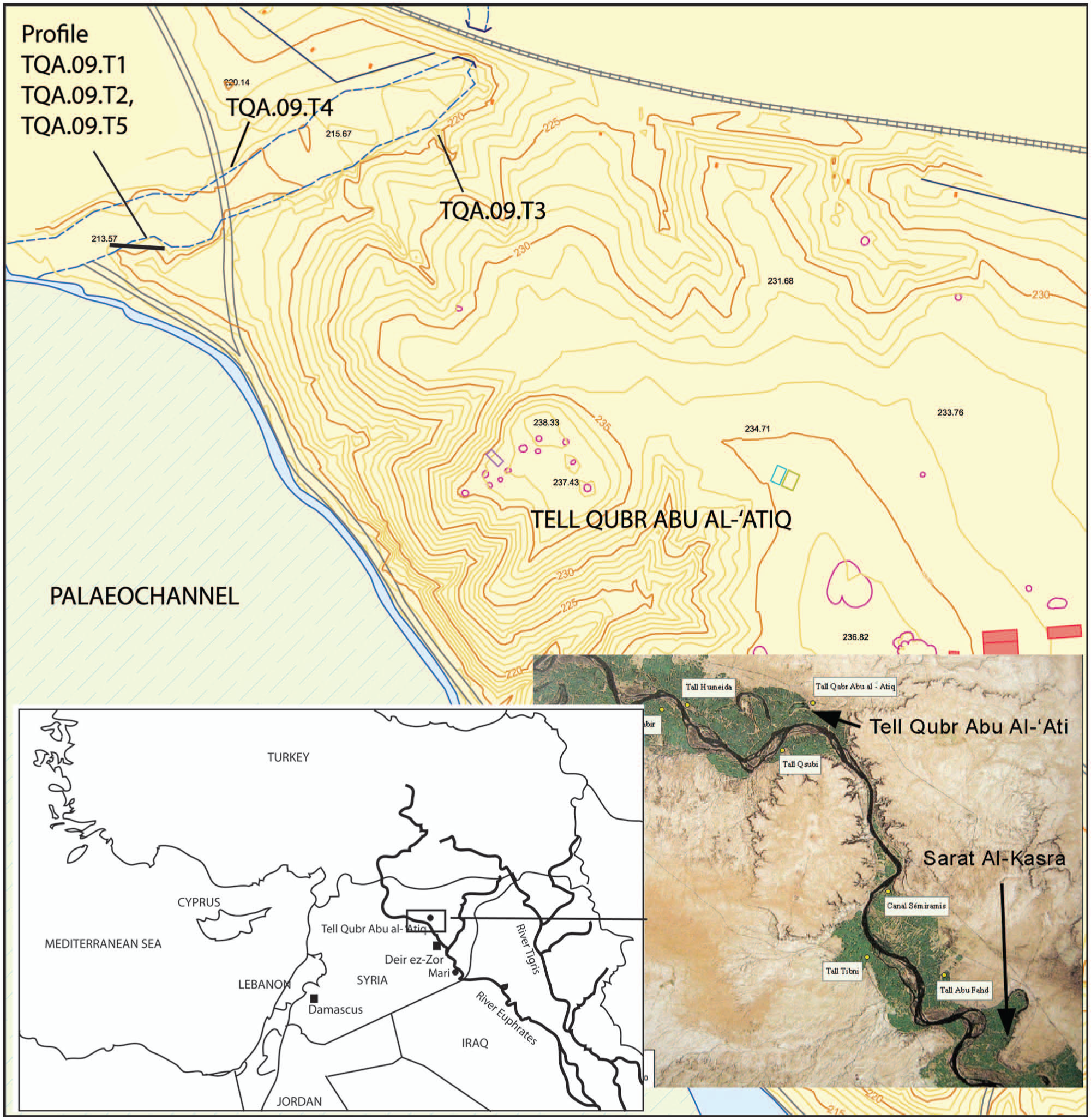
Map and location of the area, sampling sites and location of TQA.
The aim of this study is to test such a hypothesis, by studying and dating the sediment infill of a palaeochannel nearby TQA, linked to a neighbouring wadi that incises a Pleistocene terrace. We have also studied other sidewall deposits of the wadi and the incised Pleistocene terrace (Besançon and Sanlaville, 1981) to assess the reliability of the studied sequences.
Methods
Three samples (TQA.09.T1, TQA.09.T2 and TQA.09.T5) were dated from a dug section of the palaeochannel infill. A pottery fragment was taken for TL dating from the same layer as the bottom sediment sample (TQA.09.T2C) as combined analysis of sediments and unheated materials has been found relevant to identify chronological phases (Burbidge et al., 2014). A further two samples (Figure 1) were taken from the present wadi sidewall sediments (TQA.09.T3, TQA.09.T4). The Pleistocene terrace incised by the wadi is not suitable for OSL, as it is composed of massive pebbles and cobbles; therefore, two samples were taken from sandy layers from an equivalent gravel-rich terrace (SAK.09.1, SAK.09.2) located in ‘Surat Al-Kasra’ (Figure 1; Demir et al., 2007). No charcoal of organic matter was found for radiocarbon dating.
Both OSL and TL dating were performed on coarse quartz extracts. A single-aliquot regenerative dose (SAR) protocol (Murray and Wintle, 2000) was used to estimate the equivalent dose (ED) of small aliquots. All measurements were taken on an automated Risø TL/OSL-DA-15 reader equipped with an internal 90Sr/90Y source that provides 0.130 ± 0.003 Gy/s and an EMI9635QA photomultiplier tube with an optical filter Hoya U-340. Prior to OSL measurements, 180°C and 240°C preheat temperatures were chosen for TQA and SAK samples, respectively, after performing preheat tests. Recovery tests were also performed after bleaching aliquots in the OSL reader and administrating a beta dose approximately equal to the natural dose.
For the pottery sample, a TL additive dose protocol was used (Aitken, 1985) to estimate the ED. Beta irradiation was performed 2 weeks before TL measurements. To test for sensitivity changes, first and second TL growth curves were compared.
The annual dose rates (Aitken, 1985) of sediments were estimated from radioisotope activity measurements in a Canberra broad energy gamma spectrometer. The internal dose of the pottery fragment was estimated from U, Th and K contents measured by ICP-MS. Conversion factors of Adamiec and Aitken (1998) were used to estimate annual dose rates (Table 1) neglecting the alpha dose and correcting the beta dose. The cosmic dose was calculated according to Prescott and Hutton (1994).
Radioactive activities, total dose rate, equivalent dose and final age of the samples (TQA.09.T2C data for U and Th in ppm, and for K in % content).

The Th and U activity concentrations for the sample TQA.09.T2C are provided in ppm and the K activity concentration in %.
N: number of accepted/measured aliquots.
The age of sample TQA.09.T2C was estimated by TL.
Results
Sediment characteristics
The studied sequences consisted of alternating layers of poorly sorted sand matrix with variable amounts of pebbles, cobbles or both. The palaeochannel infill consisted of alternating layers of poorly sorted sand–gravel with abundant or scarce pebbles and cobbles (Figure 2). This indicates vigorous flash-flood conditions in the wadi. Three thin layers of fine-grained clayey silt were observed in the palaeochannel infill (and dated by OSL) related to weaker flows, steady slow flows and/or intensive land use (Deckers and Riehl, 2007).

Pictures and stratigraphic columns of the studied deposits: (a) sidewall of the wadi, (b) short sidewall of the wadi and (c) palaeochannel infill. Vertical black bars indicate 20 cm.
The dated sidewall sediment TQA.09.T3 was collected from a layer with few abundant pebbles on a short profile of 70 cm thickness (Figure 2) formed by alternating layers of cobbles and pebbles in poorly sorted sand–gravel matrices. Such characteristics are also indicative of vigorous flash-flood conditions. The sample TQA.09.T4 was collected from a younger sidewall (2 m height) of alternating layers of cobbles and/or pebbles in a poorly sorted sandy matrix (Figure 2), revealing alternating vigorous and less vigorous flows.
Luminescence ages
The samples show no secular disequilibrium for 238U and 232Th series, while 40K activity (Table 1) decreases with depth in the palaeochannel infill. However, age estimates will not be dependent on the external dose rates as observed in other studies (Richter et al., 2014). The estimated water content is ~3–8%, except for TQA.09.T1 (13%) and TQA.09.T2 (~30%), taken a few centimetres above the present river water table.
OSL shine-down curves display rather dim natural and regenerated OSL signals providing scatter EDs. For alluvial sediments, the daylight bleaching of water-transported grains can be limited by light attenuation through a water column and turbidity, causing age overestimation. We have used the internal–external consistency criterion to calculate the EDs, as this method has proven to be reliable for alluvial flash-flood sediments (Medialdea, 2013; Thomsen et al., 2007). The younger samples showed very low EDs (Table 1), susceptible to undergoing a phenomenon known as thermal transfer (Madsen and Murray, 2009) that also causes age overestimation. Our thermal transfer experiments, which consisted of measurements carried out on several aliquots per sample at increasing preheat temperatures after bleaching (Rhodes, 2000), have shown negligible transfer below 260°C preheat. Recovery tests showed satisfactory measured/given dose ratios from 1.05 ± 0.03 to 1.1 ± 0.08.
Resulting OSL ages (Table 1) range from 2.65 ± 0.24 to 0.68 ± 0.11 kyr BP for the palaeochannel infill. From such data, we can estimate two different sedimentation rates: a first period between 2.65 ± 0.24 and 2.46 ± 0.23 kyr BP with a rate of ~0.36 cm/yr, and a second period between 2.46 ± 0.23 and 0.68 ± 0.11 kyr BP with ~0.045 cm/yr. The pottery fragment (TQA.09.T2C) provided an age of 3.02 ± 0.34 kyr BP, fitting the age of the sediment layer where it was found and the last occupation of TQA (3.4–2.9 kyr BP) period within errors. The wadi sidewall ages are 1.27 ± 0.11 and 0.52 ± 0.09 kyr BP. The ages of the SAK terrace are 16.01 ± 3.01 kyr and 15.57 ± 2.55 kyr for SAK.09.1 and SAK.09.2, respectively. We assume that this is the age of the terrace incised by the wadi regarding previous geomorphological models as we explain in the next section.
Discussion
The few previous OSL ages reported from the Middle Euphrates provided large age errors, as did ours (Deckers and Riehl, 2007; Hilgers, 2011; Sanjurjo-Sánchez and Montero Fenollós, 2012; Sanjurjo-Sánchez et al., 2008; Vandenberghe, 2011) in all cases because of the obtained dim signals. However, such ages allow correlating sediments with floods and strong rain events, as evidenced from the sediment characteristics and previous studies (Deckers, 2011; Deckers and Riehl, 2007; Kaniewski et al., 2011).
The samples of the terrace equivalent to these incised by the wadi (SAK.09.1 and SAK.09.2) correspond to the late Pleistocene (16.01 ± 3.01 kyr and 15.57 ± 2.55 kyr BP, respectively) in agreement with the hypothesis of Demir et al. (2007) for the terraces that reaches 30 m above the present river channel. However, our OSL age is the first absolute age reported that supports such hypothesis.
The bottom layers of the palaeochannel (TQA.09.T2 and TQA.09.T1) were significantly deposited after the abandonment of TQA (~2.9 kyr BP) and the apparent end of the aggradation phase of the Middle Euphrates (~3.3–2.9 kyr BP), although there is no agreement for the time frame of this phase (Reculeau, 2011). In the Late Bronze Age, the abandonment of similar sites has been related to different causes, namely, climatic changes, deforestation or social conflicts (Deckers, 2011; Deckers and Riehl, 2007; Wilkinson, 1999). Palaeoclimatic studies recorded moist climatic conditions in the Near East up to 4 kyr BP (Figure 3), followed shortly by a drier period (Kuzuçuoglu and Marro, 2007; Weiss, 2012; Wick et al., 2003) but underline an important regional variability in such period. Intermittent, poorly sorted, massive gravel sediments of wadis in nearby sites have been related to aggradation and sporadic high-energy deposits, flash floods and exceptional rain, because of climatic drying during 3.3–2.9 kyr BP (Deckers and Riehl, 2007). It is supposed (but uncertain) that incision and meandering started at the end of that period (Reculeau, 2011). However, large-scale irrigation systems and deforestation have also been suggested as a cause of environmental changes between 3.3 and 2.6 kyr BP, from observations of pollen records of riverine vegetation (Deckers and Riehl, 2007; Reculeau, 2011). Such deforestation is coherent with a pollen record of TQA (López Sáez, personal communication) and affected fauna, as has occurred with elephant (Elephas maximus) extinction in the area, related to changes in vegetation and hunting (Becker, 2005; Reculeau, 2011). Elephant bones were reported in the area until 2.9–2.8 kyr BP (Becker, 2005), and a left fourth metatarsal of an elephant was recovered during the TQA excavation (Evangelia Tsoukala, personal communication), this being one of the most recent records in the Near East. Thus, we cannot discard anthropogenic activities as the cause of environmental changes that affected river dynamics in the studied area, but from our data, we consider that caution is needed before establishing a time frame for the end of the aggradation phase between 3.3 and 2.9 kyr BP.

Obtained OSL ages compared with environmental data plots: (a) relative palaeoclimatic proxy data, based on stable oxygen isotopes of the Van Lake (Wick et al., 2003) and (b) climatic changes and pollen features during the occupation of TQA and shortly after (palaeochannel infill). The black line of the cultivation plot means abundance (%) of Poaceae cerealia pollen and the grey line abundance (%) cultivated species (data from Kaniewski et al., 2010).
The high sedimentation rate estimated for the bottom layers of the palaeochannel (~0.36 cm/yr) is similar to that reported for sediments assigned to the aggradation phase (~0.28–0.5 cm/yr), mostly dated by pottery styles and radiocarbon around 3.3–2.9 kyr BP and correlated with intense erosion of soils, which contradicted the significant deforestation observed in several records after 2.9 kyr BP (Reculeau, 2011). Studies on the modelled mean May discharge of the river (Riehl, 2009) show that our ages fit a high discharge peak (~1050 m3/s) between 2.8 and 2.5 kyr BP (vs ~770 m3/s before and after). Similar palaeochannel infills have been dated in nearby sites around 2.8–2.5 kyr BP (Deckers, 2011). Thus, we cannot dismiss that meandering in the TQA river stretch was related to such peak discharge and deforestation induced after 2.9 kyr BP. Moreover, climatic records indicate relatively dry conditions in the Near East (after a more humid period) in 1.2–1.0 kyr BP (Bar-Matthews et al., 2003; Kaniewski et al., 2011). Such period fits the age of TQA.09.T3 and a significant peak discharge (~1650 m3/s) of the river (Riehl, 2009). The top layer sample of the channel infill (TQA.09.T5) and the other wadi sidewall sample (TQA.09.T4) are also coherent with a drying period between 0.8 and 0.6 kyr BP and a peak discharge of ~1500 m3/s (Bar-Matthews et al., 2003; Kaniewski et al., 2011; Riehl, 2009). From these data, it seems that the wadi sidewall sediments correspond to younger floods that can be correlated with climatic events, but we cannot discard other causes because of our age errors and the lack of data on sedimentation rates to compare.
In summary, large age errors, the regional climate variability and overlapping anthropogenic degradation and climatic changes prevent us from finding a single cause for floods and changes in the river dynamics of meandering in the area. However, our results prove that the active river channel moved further from TQA after its abandonment, with a loss of geostrategic interest, fitting our initial hypothesis. This was a very probable reason because TQA was not reoccupied as occurred in nearby sites, although other causes such as changes in settlement patterns cannot be completely discarded.
Conclusion
We have used OSL dating to correlate the abandonment (~2.9 kyr BP) and lack of reoccupation of a Late Bronze Age archaeological site (TQA) in the Middle Euphrates with meandering and aggradation between 2.9 and 2.4 kyr BP (TQA.09.T2 age), although social–political causes patterns cannot be completely discarded. The site was located in a geostrategic control point of the river, and it was destroyed by a fire (borderline or war conflict), but after meandering, the Euphrates main channel remained far away from the new river channel with the subsequent loss of geostrategic interest. The palaeochannel was filled with flood sediments from a neighbouring wadi that flowed into the river. Because of the large age errors obtained, the regional variability of climatic records and overlapping anthropogenic degradation and climatic changes in that period, we cannot determine a single cause for meandering. However, from our data, we consider that caution and more studies are needed before establishing a time frame for the end of the aggradation phase of the Middle Euphrates.
Footnotes
Funding
This research was funded by projects Investigaciones Arqueológicas en el Medio Éufrates (HAR210-15866, Ministry of Economy and Competitiveness, Spain) and Expedición arqueolóxica da UDC no Medio Éufrates Sirio (10PXIB 167197PR, Xunta de Galicia, Spain).