



Abstract
For the period of the Neolithic lake-shore occupation on Lake Constance (~4000–2400
Introduction
With its ability to date precisely and directly settlement structures and artifacts (Kaeser, 2008), dendrochronology created a first revolution in archaeology, and particularly in the European pile-dwelling research. This is illustrated by the publication of dendrodates for prehistoric pile-dwellings north of the Alps as a result of cooperation between several tree-ring laboratories under the leadership of B. Becker (Becker et al., 1985). At that time, dendrotypology was established at Hemmenhofen 1 for dating purposes as well as for evaluations of large timber assemblages involving a huge proportion of young wood as in the case of Hornstaad-Hörnle I (Billamboz, 1985, with final publication in Billamboz, 2006). Dendrotypology also benefited from the advances made in dendroecology (Schweingruber, 1993, 2001), and this has led to a second revolution in pile-dwelling research and wetland archaeology.
Common trends and regional patterns are two core topics in the study and patrimonial management of the Prehistoric pile-dwellings around the Alps, which were recently added to the UNESCO’s World Heritage List in 2011 (Menotti, 2012; Suter and Schlichtherle, 2009). At a lower resolution of time, the topic of ‘common trends’ is preponderant in the field of environmental studies related to pile-dwelling research (Jacomet and Schibler, 2010; Schibler, 2004). This is also the case for the question of climate evolution and subsequent lake-level fluctuations (Magny, 2013). Indeed, such approaches are of particular interest for the Neolithic period retained here, when people settled on the lake-shores of the Northern-Alpine foreland between 4000 and 2400
The topic of ‘regional patterns’ has not received so much attention, but dendrotypology now opens up new possibilities in this area of research. With moderate sources of oak timber supply in a landscape largely covered by beech forests since 3500
Methods: from dendrochronology to dendrotypology
During the last 30 years, a wood sample archive has been established during the course of large-scale excavations, small sondages, and further wood sampling areas (to date round 100,000 woods documented, 24,000 dendro-samples). The chronological work initiated with B. Becker (Becker et al., 1985) led to the definition of regional chronologies (Bodensee, Upper Suevia), the sample spread of which reflected a wave-like development of woodland (Billamboz, 2005). Systematic sampling has resulted in a high proportion of young wood, and so dendrotypology is based more on the visual matching of growth-ring curve than standard dendrochronology. Growth reaction characteristics reflecting stand dynamics, human activities, and climatic or biotic effects are observed on raw, non-detrended tree-ring series and are retained as cross-dating markers. However, for consistency and reliability of the results, the dating process operates at three distinct levels (Billamboz, 2008): Level A – independent dating using standard methods of dendrochronology; Level B – context-dependent dating supported by other information; Level C – tentative dating used principally as a basis for hypothetic evaluations and simulations. Consequently, longer consistent chronologies reflecting the development of mature stands at local and regional scale are principally established on A-dated series, whereas the combination of B-dated series contributes to the definition of shorter sub-chronologies reflecting stand dynamics of young forests or understory structures. If necessary, the dating of such short sub-chronologies is supported by radiocarbon wiggle matching techniques. In Hemmenhofen, ‘atelier dendrotypologique’ is organized as a working unit on two interconnected PCs in the following manner (Billamboz, 2014a): a laboratory dendro-package linked to a databank system (one databank per site for the large timber series and a general one embracing the smaller datasets, facilities for systematic correlations), graphical interface (visual matching facilities with curve display on respective layers), and CAD-map (control of the dendrotypological process with regard to the archaeological building structures). Constructed in this way, dendro-groups can be easily developed, assembled in longer chronologies or used separately to approach the different aspects of the investigation.
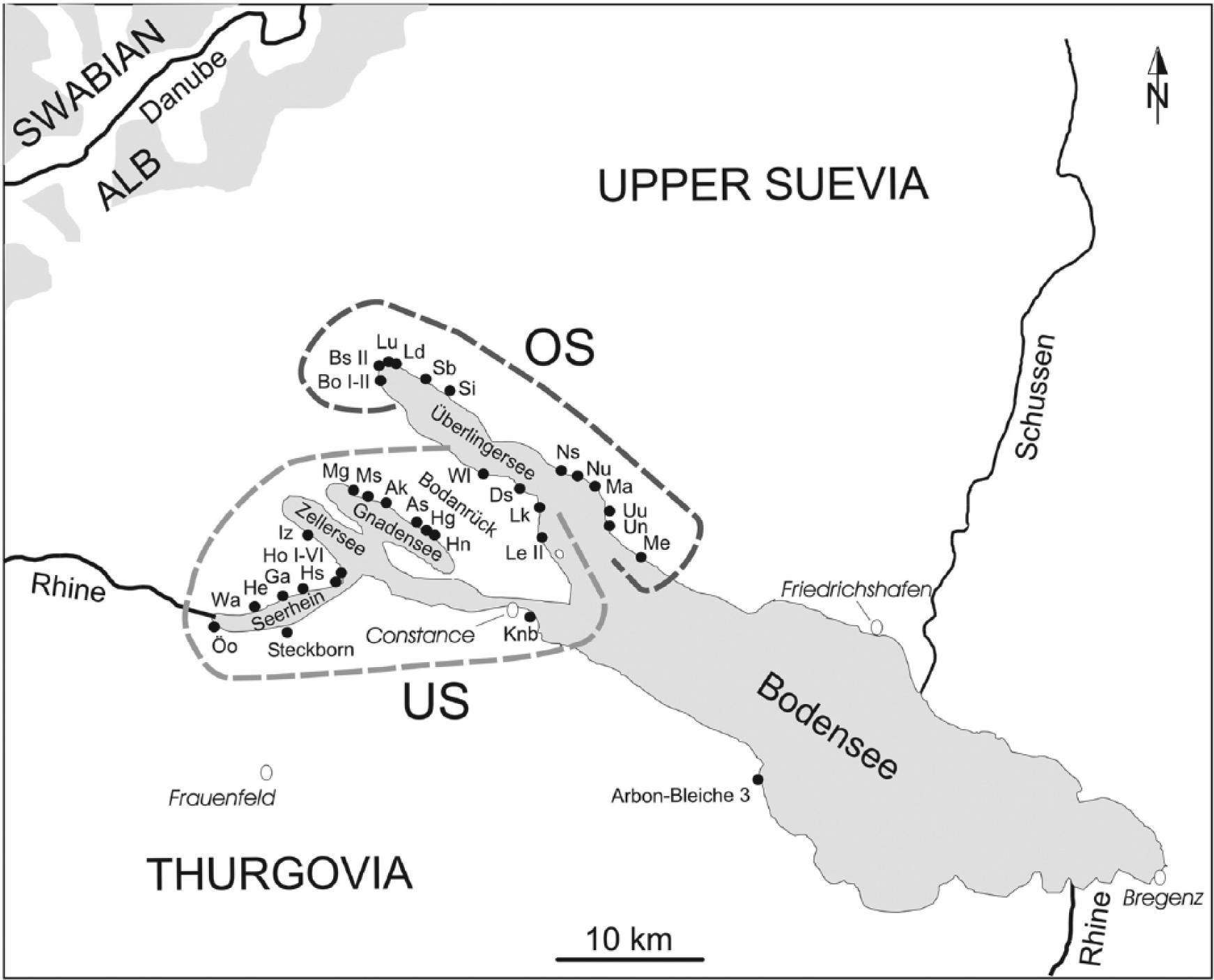
The dendrotypological skills needed to sort timber in terms of wood anatomy, tree-ring analysis, and wood working are briefly summarized here. Grouping tree-ring series according to cambial age and growth trend allows a better control in chronology building as well as in the tentative dating of young wood, which is frequently found on wetland sites. In the same way, dendrotypology can be a basic tool in the reconstruction of building history, especially in the detection of house foundations in dense post fields resulting from repeated building activities in the same place. This is particularly the case for the Neolithic pile-dwellings, where timber supply is assumed to have been conducted at household level without redistribution of converted wood within the community. Furthermore, the development of dendro-groups allows an insight into the age structure of the exploited stands with reference to dendrotypological models of woodland management derived from historical woodland practices (Billamboz, 2010, 2011). From this perspective, dendro-groups are considered as basic units of a multiple approach addressing the technological and social, as well as economical and ecological aspects of settlement development and woodland use. For the purpose of synopsis of the period under consideration here (Figure 2, cf. reference site map in Figure 1), dendro-groups are illustrated as a bar (bar length corresponding to the estimated tree age) ending in a circle representing the averaged circumference of the tree stems. Figures 4 and 5 present the averaged tree-ring curves of such dendro-groups in greater detail for shorter periods of time.
Patterns of settlement and woodland developments: a comparison between Obersee and Untersee at Lake Constance
Pile-dwelling settlements are distributed around the Western shores of Lake Constance (Figure 1). As described by Schlichtherle (2005), successive cultures are (1) during the ‘Jungneolithikum’, group of Hornstaad (4000–3900
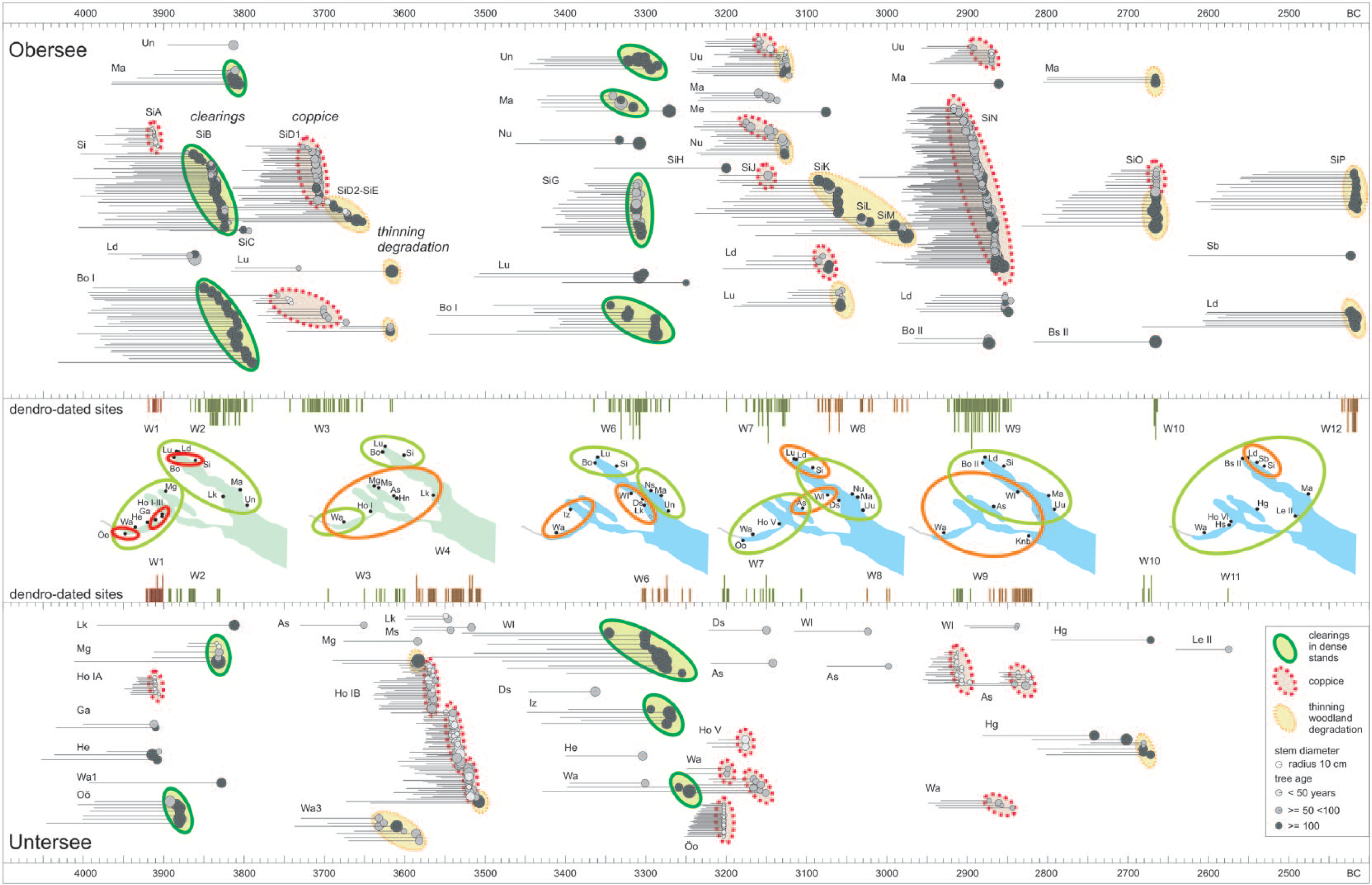
Dendrotypology highlighting patterns of woodland and settlement developments around the Obersee (OS, above) and the Untersee (US, below). For both areas, dendro-groups (bar length ~ tree age) are presented as a bar diagram ending with a circle corresponding to the mean circumference of the stem. The dendrotypological distribution is modeled with an ellipse (see legend in the figure, on the right below). Acronyms refer to the code of the sites on Figure 1 (with detail of building phases in case of major sites like Si and Ho I). In the middle, the distribution of sites and relocation of settlements are presented in different chronological sections with regard to the respective number of dendrodated villages in both areas.
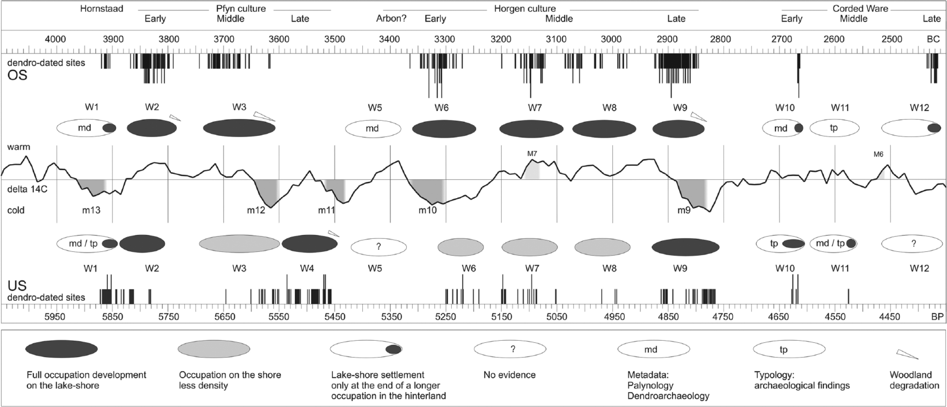
Settlement waves of the Neolithic pile-dwellings in both areas of Lake Constance. With regard to the dendrodates (see Figure 2) and to the climate evolution (14C residual curve with M, grand maxima, and m, grand minima, of temperature as calculated by Usoskin (2008)), the settlement waves are modeled with the help of ellipses.
W1. The first evidence for lake-shore settlement is to be found shortly before 3900
W2. The initial phase of the Pfyn culture is characterized by synchronous clearings of natural forests in both parts of the lake. On the Obersee, in Bodman and Sipplingen, one can note the succession of two villages at different places on the shore during this period. As already expected from the first investigations in the eastern part of the bay so far, the second village in Sipplingen (SiC) shows a more restricted extension, probably as a consequence of the thinning process of woodland.
W3. After a short gap probably because of the time required for forest regeneration, a new settlement wave took place at Obersee, characterized by the use of young wood. Repeated coppicing enabled large-scale settlement to develop at Sipplingen (SiD) (Billamboz et al., 2010). Similar patterns can be found in the neighboring villages of Bodman and Ludwigshafen (Figure 4), and this occupation wave ends with the use of old-aged oaks. The high degree of stem conversion for the construction of the last housing units reflects the increasing difficulties of suitable timber supply. Such a situation is also seen at Untersee around 3600
W4. A new wave of occupation has been recorded around the Untersee, enhanced particularly through the systematic tree-ring investigations in the village of Hornstaad-Hörnle IB (Billamboz, 2006). In contrast, there is no settlement evidence in the Northern Obersee area. It is proposed that as a consequence of land overuse and territorial exhaustion in OS during W3, settlement relocated to the south around the Untersee. This phenomenon may also be connected with the climate evolution (see below).
W5. During the 35th century
W6. At Obersee, a new wave of occupation is recorded in the second half of the 34th century
W7. As in the previous cycle observed in W2–W3, settlement developments after the initial clearings are characterized by increasing coppice practices. Lake-shore occupation in both areas takes place under warmer conditions of climate, particularly around 3150
W8. With evidence restricted in OS until now, this wave is characterized by the use of old-aged oak trees at the end of this second exploitation cycle, particularly at Sipplingen (SiK, SiL, and SiM).
W9. Around 2900
W10. Waves 10, 11, and 12 represent short-term occupations of the Corded Ware Culture on the shore of Lake Constance. Together with earlier dendrodates from Steckborn on the Swiss lake-shore in Thurgovia (Köninger and Billamboz, in press), the slight shift in the data concentration reflects the movement of this new cultural development from the Untersee to the Obersee.
W11. This intermediate wave is represented by only one dendrodated site (Le II) on the N-facing side of the Bodanrück at Obersee. Archaeological evidence indicates that this phase should correspond to a major settlement development in the hinterland (Köninger and Billamboz, in press). This assumption is supported by palynological records in the Mainau region (Lechterbeck et al., 2014).
W12. This short wave at the end of the Neolithic lake-shore occupation is only represented in the NW-part of the Überlingersee. In contrast to earlier occupation phases which indicate that the timber supply was coming from the lower slopes behind the settlement of Sipplingen (Quercus robur, pedunculate oak with high juvenile growth rate and strong negative growth trend), we can argue that the oak trees felled during this phase came from a higher altitude, in mixed-oak stands dominated by Quercus petraea [Matt] Liebl. (low radial growth with early wood vessels mostly disposed on a single row, absence of growth trend in relation to poor nutritive conditions on thin soils). Similar features in the oak series from the other neighboring dated sites in this wave indicate a general relocation of timber supply in this area at that time, probably because of deforestation of the lower slopes.
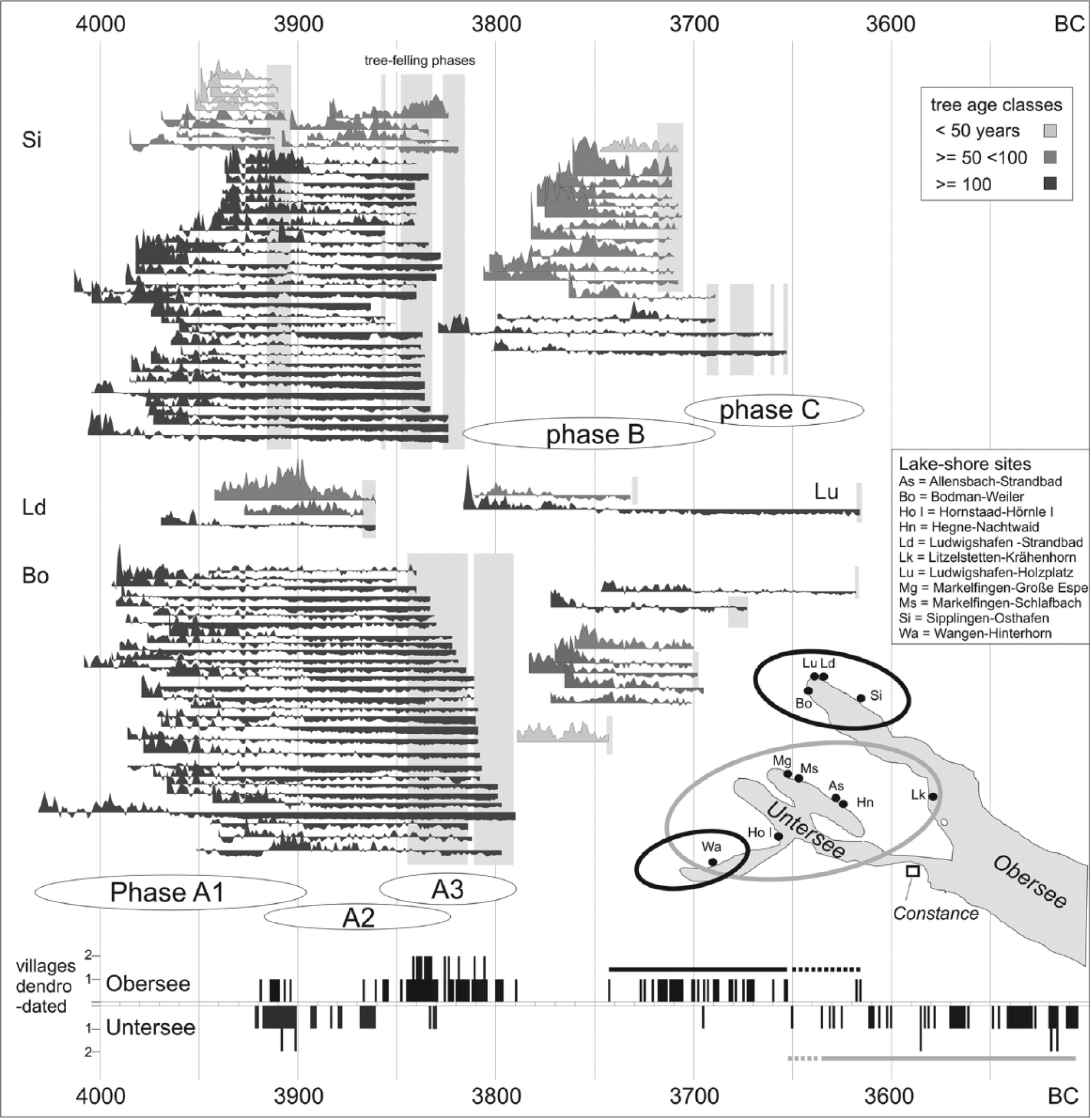
Detailed dendrotypology modeling a long cycle of woodland exploitation in Western OS in the first half of the 4th Millennium

Detailed dendrotypology showing subregional developments around the Überlingersee at the interface W5–W6 in the initial phase of the Horgen culture. Above synchronous regeneration marks the presence of settlement activities on the South facing slopes, whereas long oak tree-ring sequences below indicate that the less attractive Northern slopes of the Bodanrück were already abandoned to the forest.
Moving territorial boundaries in a mosaic-like landscape shaped by forest dynamics?
Taking into account the archaeological evidence from the hinterland and by comparison with more regional patterns, the settlement waves can be more generally characterized as follows (see ellipses in Figure 3):
Pioneering phases (initiating both woodland exploitation cycle and cultural development, ellipse filled in black or gray according to the degree of evidence). Good examples are W2 and W6 at the beginning of the Pfyn and Horgen cultures, respectively. Timber is supplied in more or less natural mixed-oak forests, although with a higher stand density in W2. As shown in Sipplingen (SiB), the village began in 3860
Settlement expansion coupled with coppice practices (same ellipse as first situation). Secondary woodland development in previously cleared forest enables a new wave of settlement. With more than 100 household units, the village SiC in the eastern part of the bay in Sipplingen provides a good example of this development during W3. Abrupt growth changes in the young oak tree-ring series reflect successive coppice rotations. The settlement on the shore must be considered as part of a larger system with the hinterland. W7 in the Late Neolithic period represents a similar situation with coppice development after clearings, but based on shorter rotations of 15–20 years in relation to a more intensive land use (e.g. in Nußdorf-Strandbad, not detailed here). Around 2900
Settlement reduction or relocation as a consequence of land overuse and woodland degradation. As a result of the constraints subsequent to the loss of forest resources, these waves are characterized by only a short period of occupation on the shore, but these arise for different reasons. The brief settlements at the end of W3 and W8 represent the final phase of the exploitation cycles described above, while W10, W11, and W12 (small black ellipse on a larger white one) reproduce the settlement relocation to the shore at the end of long-term occupation elsewhere in the hinterland. This is also the case for W1, when people of the Hornstaad group moved to the shore between 3920 and 3900
Settlement in the hinterland only without evidence on the lake-shore (white ellipse). Two cases are to be found in W5 and W11 (US, see comment above on the delimitation of both subregions).
Climatic impacts on these settlement patterns are outlined only briefly here because there is already an abundant literature on this topic (Magny, 2013; Nicolussi et al., 2013). The regional climatic variations based on the 14C residual curve are presented in Figure 3.
Cold conditions which, together with a reduction in human settlement pressure, allow the forest to regenerate. This is the case before W6 during the course of the well-known cold phase Piora 2 (temperature grand minimum m10 – Figure 3), showing a major peak of beech in the palynological records of the region (Rösch, 1993).
Warmer conditions favoring settlement development (e.g. W3 or W7 during the temperature grand maximum M7 after Usoskin (2008)).
Combination of climatic and ecological factors. This is probably the most common situation, when people were affected by the loss of resources at times of climatic extremes. It is noteworthy that at the time of the two grand minima m12 and m11, the lake-shore occupation at the end of W3 and during W4 was concentrated around the Untersee. This area, with its more structured mosaic of landscape, offered better opportunities for combined subsistence strategies, including pastoral activities as well as fishing and fowling.
In the French Jura mountains, an alternating ‘come and go’ rhythm in the lake-shore settlements of Chalain and Clairvaux has been observed during the Late Neolithic period from the 32nd to the 30th centuries
Conclusion and future prospects: toward a better balance between climate forcing and ecological sustainability
The evidence presented in this paper allows a first definition of regional settlement/woodland patterns, of their variable duration and succession in time. It is likely that the integration of data from sites on the Swiss lake-side, such as Thurgovia, will improve this definition. On the basis of these patterns, the strong relationship between prehistoric pile-dwellers on Lake Constance and their forestal environment has been clearly illustrated. From this perspective, one may underline the skills of dendrotypology, allowing the enhancement of socio-economical developments of such small and unstable communities and reflecting in the steps of generations their difficulties to manage the territorial resources at longer term, especially in the case of strong fluctuations of population as indicated by dendrochronology. However, such detailed data can be integrated in the consideration of developments at larger scale and crises such as those induced from climate (Schlichtherle, 2011).
Finally, further prospects can be seen in the development of dendrotypology within the framework of dendroarchaeology or even in other domains of tree-ring research and forest sciences. In the Circum-Alpine pile-dwelling research, settlement development is generally evaluated at the centennial scale, researchers arguing about the evolution of climate and subsequent lake-level fluctuations or on cultural processes related to agriculture or metallurgy. For instance, they act more rarely on a combination of both natural and cultural factors. Based on multi-scalarity, climate reconstructions from tree rings are able to address more accurately the middle to short-term variations within such evolution. At lower altitudes, oak ring width variability can be evaluated for the reconstruction of early summer precipitations which favor agriculture (Büntgen et al., 2011; Nicolussi et al., 2013). What is also promising is the recording of pointer years through the systematic exploration of single events and calculation of growth tendencies. Dendrotypology, with its high degree of contextualization and its application to various aspects of archaeology and natural sciences should be more integrated into this approach in the future.
Improvements can be made through the consideration of ecological parameters (i.e. abrupt growth changes and characteristic ring and growth patterns after Bleicher (2009, 2013); cockchafer signal in oak tree-ring series enhancing outbreaks of Melolontha populations taking benefit from clearing activities in terms of facultative synanthropy as defined by Kennward (1997; Billamboz, 2014b)). A further parameter to be considered concerns the proportions of oak sapwood, which reflect the social status of the tree in the stand structure because it is dependent on the amount of available light (Girardclos et al., 2012; Roussel, 1978). Stand density can then be assessed by the calculation of an index which takes into account the whole sapwood width divided by the number of sapwood rings (high index value = large amount of sapwood formation in a few years, which reflects a quicker duramenisation under a lower degree of tree competition in non-dense stands).
With the relocation of the timber supply at higher position in times of wood scarcity, the evidence from Sipplingen raises the delicate question of site catchment because this example of reorientation of timber sources underlines clearly the limitations of sustainable settlement activities within a direct action radius, which generally should not exceed a distance of about 2 km at that time. It is already known that settlers during the ‘Jungneolithikum’ period (4200–3400
A particular task concerns the question of oak coppice sustainability in phases of demographic development. As observed at Hornstaad-Hörnle IB (Billamboz, 2006), there is a correlation between population decrease and coppice aging. In a time where people were largely dependent on their forest environment, it is likely that the constraints encountered here are to be explained by difficulties affecting the management of coppice. The question of oak coppice sprouting (Matula et al., 2012; Pyttel et al., 2013) was still a problem in woodland management in historical times, and one should pay more attention to this aspect in future research. Dendroarchaeology needs to be more closely linked to dendroecology and forest sciences through actual models of forest dynamics on abandoned land surfaces (Rameau, 1999) as well as through historical ecology (Rackham, 1993), where similar patterns of woodland use have been derived from written documents and historical maps (Dupouey et al., 2002). Regarding the modi and rhythms of land use, people in pile-dwelling research around the Alps still use the long lasting open land traditions in the Near Eastern cradle of agriculture as a model, but more suitable models might be provided by considering the pioneering agriculture within woodlands in Northern America, exemplified by the Iroquoian tribes along the Saint-Laurent river (Behel, 2013).
The consideration of such models for dendroarchaeological comparison between pile-dwelling settlements North and South of the Alps could also contribute to solving the dilemma of ‘climate versus culture’ as discussed in the French Jura and on the Swiss Plateau (Arbogast et al., 2006; Pétrequin et al., 2005). Finally, the focus on woodland history and former sylvicultural processes should help people to reconnect with their past forest environment in many regions of the Circumalpine foreland where deforestation and high forest conversion have led to a loss of memory concerning the primary environment of Neolithic people in Middle Europe. As an interface between archaeology and the natural sciences, dendroarchaeology supported by means of dendrotypology may help to improve our understanding of the environment of the pile-dwellings and their socio-economic developments. So far as allowed by the preservation of large timber series, the way is also already open for similar applications in other domains and for other periods.
Footnotes
Acknowledgements
I would like to thank Anne Crone, Edinburgh, for the stylistic review of the manuscript and for helpful comments.
Funding
The project ‘Das Sipplinger Dreieck als Modell jung- und endneolithischer Siedlungs- und Wirtschaftsdynamik am Bodensee’ has been supported by the German Council of Research (DFG PL 95/49-1/SCHL 398/2-2).