
Abstract
The Marboré Cirque, which is located in the southern Central Pyrenees on the north face of the Monte Perdido Peak (42°40′0″N; 0.5°0″W; 3355 m), contains a wide variety of Holocene glacial and periglacial deposits, and those from the ‘Little Ice Age’ (‘LIA’) are particularly well developed. Based on geomorphological mapping, cosmogenic exposure dating and previous studies of lacustrine sediment cores, the different deposits were dated and a sequence of geomorphological and paleoenvironmental events was established as follows: (1) The Marboré Cirque was at least partially deglaciated before 12.7 kyr BP. (2) Some ice masses are likely to have persisted in the Early Holocene, although their moraines were destroyed by the advance of glaciers during the Mid Holocene and ‘LIA’. (3) A glacial expansion occurred during the Mid Holocene (5.1 ± 0.1 kyr), represented by a large push moraine that enclosed a unique ice mass at the foot of the Monte Perdido Massif. (4) A melting phase occurred at approximately 3.4 ± 0.2 and 2.5 ± 0.1 kyr (Bronze/Iron Ages) after one of the most important glacial advances of the Neoglacial period. (5) Another glacial expansion occurred during the Dark Age Cold Period (1.4–1.2 kyr), followed by a melting period during the Medieval Climate Anomaly. (6) The ‘LIA’ represented a clear stage of glacial expansion within the Marboré Cirque. Two different pulses of glaciation were detected, separated by a short retraction. The first pulse occurred most likely during the late 17th century or early 18th century (Maunder Minimum), whereas the second occurred between 1790 and
Keywords
Introduction
The study and mapping of recent morainic deposits related to climatic fluctuations during the Holocene, particularly the ‘Little Ice Age’ (‘LIA’), can reveal the extent and spatial variability of the ice masses during the last millennia and how they correlate with climate and environmental changes. A good comprehension of glacial events is key to understanding the changes that have recently affected mountainous areas (e.g. the temperature increases over the last two centuries) and the importance of topographic and climatic factors in the development of small glaciers.
Studies on Pleistocene glaciations have generally ignored the climate shifts of the Holocene, which is generally believed to have had a mild, almost stationary climate (Clague et al., 2009). Nevertheless, abrupt, sometimes large climate changes have occurred since the onset of the Holocene, c. 11,700 yr BP (Marcott et al., 2013), causing remarkable glacial expansions and contractions (Bond et al., 1997; Clague et al., 2009; Davis et al., 2009; Deline and Orombelli, 2005; Mayewski et al., 2004; Wanner et al., 2011), changing the characteristics of vegetation (Fletcher et al., 2010; Jalut et al., 2009; Magny et al., 2002) and altering natural resources in ways that have had local effects on the patterns of human occupation (González-Sampériz et al., 2009). It has been demonstrated that mountain glaciers worldwide reacted rapidly to changes in precipitation and/or temperature during the Holocene, but the timing and causes of these changes remain unclear (Davis et al., 2009).
During the past few decades, Holocene climate and glacier fluctuations have been intensively studied for most mountains worldwide, particularly those in Europe (e.g. Bakke et al., 2010; Deline and Orombelli, 2005; Holzhauser et al., 2005; Jalut et al., 2000; Nesje, 2009) and North America (e.g. Clague et al., 2009; Menounos et al., 2009). In the case of the Iberian mountains, particular attention has been paid to the moraines of the ‘LIA’ (González Trueba et al., 2008). The southern latitude of the Iberian Peninsula explains why the ‘LIA’ glaciers were relatively small and restricted to the high peaks in the Central Pyrenees, Picos de Europa in the Cantabrian Range and Sierra Nevada in the extreme south (González Trueba et al., 2008). The Central Pyrenees had the highest number of glaciers during the ‘LIA’, especially at altitudes > 3000 m. Many of these glaciers have disappeared during the last four decades, and the extent of the remaining glaciers has been greatly reduced (Chueca et al., 2002). Nevertheless, many moraines have been associated with the glacial expansions of the ‘LIA’, allowing reconstruction of the ‘LIA’ sizes of most glaciers. The information provided by Schrader (1894) indicates that the ‘LIA’ glaciers occupied 3366 ha of the Pyrenees in 1876. However, we do not have any data on glaciation in the Iberian Peninsula during most of the Holocene.
The lack of information on glacial evolution during the Holocene (except for the ‘LIA’) contrasts with an increasing number of lacustrine Holocene records available from the Iberian Peninsula (Corella et al., 2011; Morellón et al., 2012; Moreno et al., 2011; Oliva and Gómez Ortiz, 2012). Collectively, these studies have demonstrated the existence of important environmental changes throughout the Holocene. The glacial response to this climate variability is unknown.
The area with the highest variety of recent morainic deposits in the Pyrenees is the Marboré Cirque. Located in the northern side of the Monte Perdido Massif, within the Ordesa and Monte Perdido National Park (OMPNP), the Marboré Cirque retains some active glaciers and has abundant and well-preserved glacial deposits. Recently, a sediment record obtained from a lake inside the cirque has reconstructed the depositional evolution of the alpine lake during the Holocene (Oliva-Urcia et al., 2013). The Marboré Cirque is very close to the Troumouse Cirque (French Pyrenees), where an important intra-Holocene advance was detected (Gellatly et al., 1992). Thus, the Marboré Cirque is a target area to study glacial evolution in the Pyrenees during the Holocene.
The main purposes of this paper are to study and date the sequence of paleoenvironmental events represented in the deposits of the Marboré Cirque, to differentiate the ‘LIA’ deposits from other possible Holocene deposits and to reconstruct the extent and evolution of the ice masses at various moments during the recent millennia.
The study area
The Marboré Cirque (Figure 1) forms a basin of 5.8 km2 at the foot of the northern face of the Monte Perdido Massif (Central Pyrenees, Spain). The cirque is bounded to the north by the Tucarroya Crest and the Astazu Peak (3071 m), to the west by the Pequeño Occidental Peak (3013 m) and to the south by a dramatic wall composed of the Monte Perdido (3355 m), Cilindro (3322 m) and Marboré (3247 m) peaks. This wall comprises a vertical cliff of 500–800 m height, with several secondary scarps composed of different Cretaceous and Tertiary rock formations. At the base of the wall, the Cinca River flows from the glaciers themselves, carving a longitudinal basin from west to east. Towards the east, the cirque opens to the Pineta glacier Valley, with an abrupt loss of altitude (c. 1000 m). The cirque altitude progressively ascends from the eastern border at 2520 m asl (called the Balcón de Pineta) towards the west. In the northern part of the cirque (i.e. at the foot of the Tucarroya Crest and the Astazu Peak), there is a narrow longitudinal depression where the Marboré Lake is located (2595 m asl). The Marboré Cirque and Monte Perdido Massif have been part of the OMPNP since 1981.

The study area.
The Monte Perdido Massif is part of the Inner Sierras, which form a main structural unit of the southern Pyrenees. The rock formations exposed in the Inner Sierras correspond to Cretaceous-Eocene limestone, marly limestone and sandstone. The compressive structural style is characterized by the stacking of south-verging thrust sheets emplaced during the Alpine orogeny. Three morphostructural units can be distinguished in the Marboré Cirque:
The Marboré Cirque has a clear structural control and it is located in a synclinorium-like structure, wherein alternating limestone and sandstone outcrops evolve towards cuestas, which become almost vertical at the extreme north of the cirque (i.e. at the Tucarroya Crest and Astazu Peak). The sandstone and limestone formations have been intensely affected by chemical and physical weathering, generating a series of small cuestas lined up WSW-ESW, with the scarps facing north. Structural karren (kluftkarren) are present, mainly because of the solutional widening of the stratification planes and joints, with solution flutes (rillenkarren) prevailing on steep slopes. Small dolines and chasms are also relatively common.
The south margin of the cirque is an abrupt and complex wall forming the northern faces of the Monte Perdido, Cilindro and Marboré peaks carved in several overthrusting folded units. Maastrichtien sandstone dominates in the western part of the cliff (Marboré), whereas Eocene limestone prevails in the eastern part (Monte Perdido), although the lower part of the cliff also has a large sandstone outcropping.
In the middle of the cirque, a dome at 2720 m asl separates the longitudinal depression of the Marboré Lake and the basin where the Cinca River flows (i.e. at the foot of the Monte Perdido, Cilindro and Marboré peaks). This dome is called the Central Threshold.
According to Del Barrio et al. (1990), the actual 0°C isotherm is located at 2726 m. Feuillet and Mercier (2012) established the 0°C isotherm at approximately 2650 m, noting that the mean annual temperature is −1.3°C on the Midi de Bigorre Peak (2877 m). To the east, in the Maladeta Glacier, the Equilibrium Line Altitude (ELA) is located between 2956 and 2959 m; in 1820–1830, it was estimated to lie about 255 m lower than that (Chueca Cía et al., 2005). The mean annual precipitation is approximately 2015 mm in the Marboré Lake (Del Valle, 1997).
Methods
The recent glacier evolution in the Marboré Cirque has been reconstructed using several methodologies: (1) reviewing all information available from historical sources and previous works, (2) performing detailed geomorphological mapping, (3) analysing some basic sediment characteristics and (4) cosmogenic dating of exposed surfaces.
A number of travellers crossed the Marboré Cirque since the end of the 18th century and during the 19th century; they described in detail the presence and extent of glaciers providing evidence of glacial evolution. In addition, scientific studies have been carried out since the end of the 19th century. An analysis of these documentary sources provided the framework for understanding the glacial evolution during the ‘LIA’ and helped us select the sampling sites for cosmogenic dating.
For geomorphological mapping, we identified morainic and periglacial deposits using the 1956 and 1982 aerial photographs and 2006 orthophotos. The survey was complemented by fieldwork during the summers of 2010, 2011 and 2012. In 2011, three generations of moraines were sampled and assessed for their grain-size distributions and carbonate contents. In 2012, an exhaustive search for polished or striated surfaces led to the identification of a few well-preserved sites with glacial erosion, which could be used for dating.
The moraine deposits did not contain organic carbon for 14C dating, and the presence of quartz or feldspar was too limited for Optically Stimulated Luminescence (OSL) methods. Since the thresholds and boulders are composed of limestone or calcareous sandstone, we decided to use the 36Cl isotope to date how long the polished bedrocks and boulders had been exposed to cosmic radiation.
Cosmogenic 36Cl is produced in carbonates by several mechanisms, including (1) fast neutron spallation on 40Ca, (2) absorption of epithermal and thermal neutrons by 35Cl and (3) the capture of slow negative muons on 40Ca (Phillips et al., 2001). Furthermore, the cosmogenic production rates of 36Cl are much higher than those of other cosmogenic isotopes (Gosse and Phillips, 2001), making cosmogenic 36Cl the most suitable isotope for dating limestone surfaces.
The geomorphological map was used to select sampling sites for 36Cl surface-exposure dating. Samples were collected from three glacial bedrock outcroppings. The selection criteria were (1) the sampling points were not glaciated during the ‘LIA’, according to our review of the historical sources and previous studies; (2) they had a protrusive morphology that minimized the chance of a previous burial by soil, sediment or snow; (3) they had a clear glacial polish, indicating no erosion after deglaciation; and (4) they had been polished by a glacier that was thick enough to erode the pre-glacial surface (thus minimizing the chance of 36Cl inheritance). Samples were also taken from two boulders representing an external deposit of grey limestone, and one from the outermost moraine, which was composed of white Eocene limestone. The selected boulders were large (>1 m × 1 m × 1 m), located on the crest of prominent deposit ridges (to reduce the chance of previous burial by soil, sediment or snow) and found on a stable part of the deposit (in order to minimize the chance of the boulder overturning or breaking). The monthly snow cover and the degree of erosion were estimated in the field, and these values were used as corrections during the age calculations.
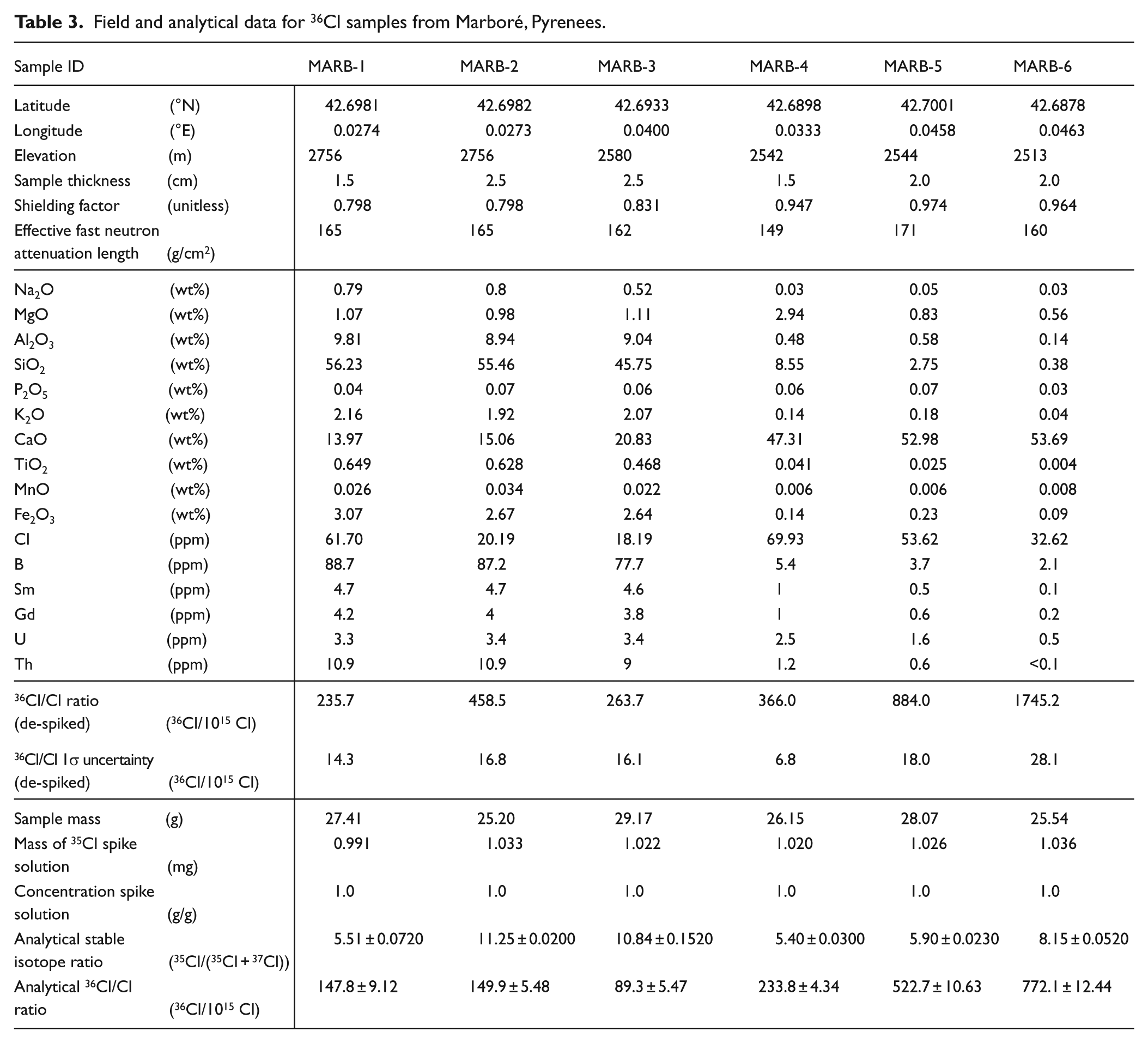
Samples were analysed following the procedures described by Phillips (2003) and Zreda et al. (1999). Briefly, each rock sample was pulverized in a roller grinder, and then dissolved in a hot mixture of hydrofluoric acid and nitric acid, spiked with isotopically enriched 35Cl. Each sample was then Cl-precipitated as AgCl, and AMS was used to measure the 36Cl/Cl and 37Cl/35Cl ratios of the AgCl targets (PRIME Lab, Purdue University). The total Cl content was determined by isotope dilution mass spectrometry; aliquots of rocks were powdered and analysed for major elements by fusion inductively coupled plasma; trace elements were examined by mass spectrometry and boron was measured (all at PGNAA; Activation Laboratories, Canada).
The exposure ages were calculated with the CHLOE program version 3-2003 (Phillips and Plummer, 1996); we used the thermal and epithermal neutron distribution equations and 36Cl production parameters applied in Phillips et al. (2001), the production of 36Cl by muons reported by Stone et al. (1998) and the latitude and elevation scaling of production rates described by Lal (1991). For the CHLOE-based calculation of exposure ages, we assumed rock surface erosion ratios of 0 (no erosion), 3 and 5 mm/kyr. The applied snow cover value was based on the present snow dynamics.
Results
The glacial evolution of the Marboré Cirque according to historical sources
The Marboré Cirque was the highest cirque of the Cinca Glacier, which was approximately 24 km in length at its maximum extent, making it one of the largest in the southern Pyrenees. Penck (1883) was the first to describe the Cinca glacier deposits corresponding to the Upper Pleistocene glacier, although its timing and maximum extent were not studied until recently (Lewis et al., 2009; Martí-Bono and García-Ruiz, 1993). The Local Last Glacial Maximum would have occurred at approximately 64 ± 11 kyr BP (Lewis et al., 2009), similarly to other Pyrenean valleys and the northern Iberian Peninsula glaciers (García-Ruiz et al., 2013; Jiménez-Sánchez et al., 2013).
The first scientist to study the Marboré Cirque and its glaciers was Franz Schrader, who traversed and described the area between 1866 and 1924. In 1873, Schrader (1874) mapped the cirque at a scale of 1:40,000, delimiting the extent of the glaciers. He later generated two additional maps at 1:100,000 (Schrader, 1882–1892) and 1:20,000 (Schrader, 1914). The extent of glaciation had not changed significantly between the 1874 report and the subsequent maps, even though the map of 1914 was much more precise, with contour levels similar to modern maps. Figure 2 includes information on the distribution of moraine deposits related to the ice masses that were cited and mapped by Schrader.
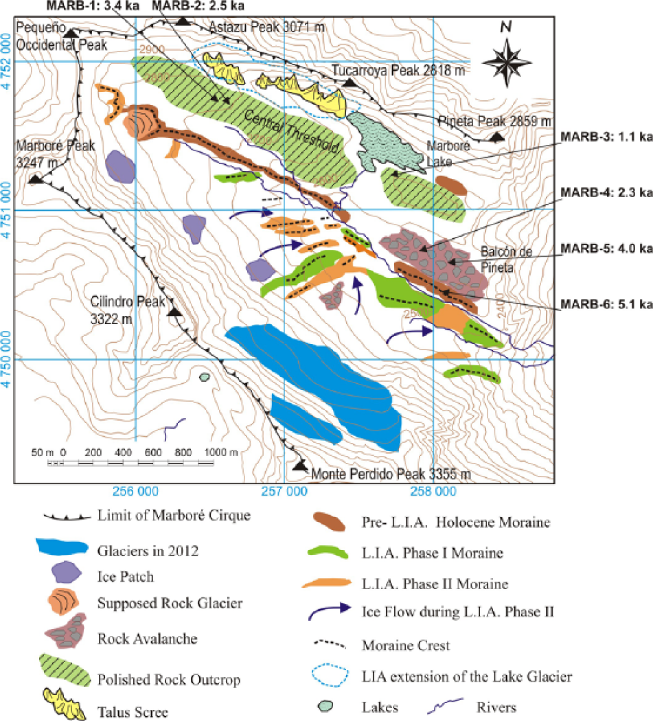
Moraines and other deposits in the Marboré Cirque.
According to the map of 1874, a small glacier occupied the base of the Tucarroya Crest and the Astazu Peak. The so-called Lake Glacier (near the Marboré Lake) was visited and described by Ramond de Carbonnières in 1797 (Bonaparte, 1891). In the southern part of the cirque, the map of 1874 describes a unique glacier (the Monte Perdido Glacier), at the foot of the large wall formed by the Monte Perdido, Cilindro and Marboré peaks. The map of 1914 divides the glacier into three ice masses, one from each of the peaks, with that of Monte Perdido extending furthest. The Monte Perdido Glacier continued towards the east, up to at least 2420 m asl. The Lake Glacier extended up to the Marboré Lake. The Central Threshold appeared to be ice-free. According to the map of 1874, the Monte Perdido Glacier covered a total of 388 ha, although this was most likely overestimated because of the presence of a large snow cover (Martínez de Pisón and Arenillas Parra, 1988). In contrast, the Lake Glacier covered only 8 ha. Several descriptions from Ramond de Carbonnières (1801) are consistent with the spatial distribution of glaciers according to Schrader and the ice-free nature of the Central Threshold. Between 1880 and 1894, several authors noted that the Lake Glacier had disappeared (e.g. Degrange, 1882), and the Monte Perdido Glacier had clearly retreated (Bonaparte, 1891). Photos taken between 1890 and 1910, most of them by anonymous contributors (Médiathéque de l’Architecture et du Patrimoine of the French Government), show a rapid retreat of the glacier front and the dead ice amid boulder chaos in the westernmost part of the cirque, resulting in a thermokarst topography.
During the 20th century, the excellent conservation of a number of glacial deposits in the Marboré Cirque facilitated various studies aimed at determining the extent occupied by the ice during the ‘LIA’. Gómez de Llarena (1936) described the existence of two types of moraines, with the oldest running parallel to the north-facing slope of the cirque, while the others were located perpendicular to the oldest. Hernández-Pacheco and Vidal Box (1946) studied the same moraines and agreed with the interpretation of Gómez de Llarena (1936). Boyé (1952b) was the first to perform a detailed study of the main moraine of the Monte Perdido Glacier, which was erroneously considered as a protalus rampart that developed because of block falls displaced over a snow and ice mantle towards the foot of the versant. Nicolás Martínez (1981) attributed a large accumulation of grey limestone boulders in the Balcón de Pineta to the Late Glacial period, and following Gómez de Llarena (1936), he considered them to be an external moraine. García-Ruiz and Martí-Bono (2001) performed a relief study of the OMPNP, including a geomorphological mapping of glacial deposits. They stated that the morainic ridges located in the southern half of the Marboré Cirque should correspond to the ‘LIA’ and identified the accumulation of grey limestone boulders as a supraglacial till that most likely belonged to the Late Glacial period. Martín Moreno (2004) attributed the accumulation of grey limestone boulders to the Late Glacial period, but noted that they could also possibly correspond to intra-Holocene advances. He proposed two glacial advance phases within the ‘LIA’, with different moraine deposits.
Recently, sediment cores from the Marboré Lake demonstrated that partial deglaciation of the Marboré Cirque occurred approximately 13 kyr ago, as the Marboré Lake was ice-free 12,700 years ago (Oliva-Urcia et al., 2013) The sediment sequence is composed of laminated silts and shows a significant change in depositional environments around 5500 cal. yr BP. Cores from La Larri paleo-lake, located 3 km to the east of the Marboré Lake, revealed that the paleo-lake developed >35 kyr ago when the valley was dammed by a lateral moraine of the Cinca Valley, and it was drained when the moraine was breached around 11 kyr ago (Salazar-Rincón et al., 2013).
These previous works provide a framework for deglaciation in the Cinca Valley. First, the Marboré Cirque was at least partially deglaciated 13 kyr ago, and no glacier has covered the Marboré Lake since then (Oliva-Urcia et al., 2013; Salazar-Rincón et al., 2013). Sedimentary analysis of the Marboré Lake cores indicates that a significant depositional change occurred in the middle of the Holocene, coinciding with the glacial advance in the Troumouse Cirque (Gellatly et al., 1992). Second, the previous studies differentiated three groups of morainic or pseudo-morainic deposits (Figure 3): (1) morainic ridges that run transverse to the north-facing slope of the cirque; (2) longitudinal, more externally located moraines that present the glacial maximum during the ‘LIA’ (García-Ruiz and Martí-Bono, 2001; Gómez de Llarena, 1936; Hernández-Pacheco and Vidal Box, 1946; Martínez de Pisón and Arenillas Parra, 1988; Martín Moreno, 2004; Nicolás Martínez, 1981), and appear to have been affected by subsequent advances (Martín Moreno, 2004); and (3) a more external complex of grey limestone boulders, located close to the Balcón de Pineta, considered of Late Glacial or intra-Holocene age, and interpreted as a moraine (Gómez de Llarena, 1936; Hernández-Pacheco and Vidal Box, 1946; Martínez de Pisón and Arenillas Parra, 1988; Nicolás Martínez, 1981), a nival protalus rampart (Boyé, 1952b) and a supraglacial till (García-Ruiz and Martí-Bono, 2001).

Rock avalanche, composed of large limestone blocks, close to Balcón de Pineta.
Geomorphological analysis of the Marboré Cirque
The map presented in Figure 2 shows the distribution of moraines and other deposits in the Marboré Cirque. Except for a small deposit to the east of the Marboré Lake, all of the morainic ridges are located in the southern part of the cirque, at the foot of the large wall of the Monte Perdido, Cilindro and Marboré peaks. Several deposits can be distinguished:
1. A large accumulation of grey limestone boulders in the Balcón de Pineta area (Figure 3). This chaotic deposit is composed of blocks that frequently surpass 5 m in the a axis without fine material; the boulders appear to be aligned on rocky crests, giving the (mistaken) impression of comprising several parallel morainic ridges. Lithologically, it is a very homogeneous deposit, with an almost absolute predominance of grey limestone blocks transported from the summit areas of the northern face of Monte Perdido Peak. The blocks do not present any angle erosion, polishing or striation, although this could be because of the rapid dissolution of the limestone surface. Notably, no other similar deposit has been found elsewhere in the cirque.
A number of authors interpreted this deposit as a glacial moraine corresponding to the Late Glacial (Upper Pleistocene) (García-Ruiz and Martí-Bono, 2001; Martínez de Pisón and Arenillas Parra, 1988; Martín Moreno, 2004; Nicolás Martínez, 1981). However, a variety of arguments suggest that this deposit represents a large rock avalanche that fell from the northern side of the Monte Perdido Peak: (1) it lacks any fine matrix, even though it is located more externally than the other Marboré Cirque moraines, which include copious fine material; (2) it is unique for its structure and texture, with no other similar deposit in the Marboré Cirque; and (3) it is an extraordinarily homogeneous deposit exclusively dominated by grey limestone, which contrasts with the lithological diversity of the Monte Perdido wall (e.g. grey and white limestone, brown Maastrichtien sandstone). We propose that this deposit was emplaced as a rock avalanche that affected the middle part of the Monte Perdido cliff.
2. A long and narrow NW-SE morainic ridge that runs from the foot of the Marboré Peak towards the east-southeast, showing a well-defined form and an acute crest 20 m above the base (Figure 4). This deposit is composed of two units: basal matrix-supported Maastrichtien sandstone blocks and a top, 2 m thick block-supported unit. The lower unit is a typical push moraine that was displaced by an ice mass, and the top unit represents the supraglacial till. The ridge decreases rapidly in height and appears to continue towards the east as a series of parallel narrow ridges that are primarily composed of white limestone blocks from the Monte Perdido Wall. The latter observation suggests that the materials from the Marboré, Cilindro and Monte Perdido peaks did not mix during the development of this moraine, and, consequently, when this long moraine was deposited, the glacier continuously occupied the southern half of the Marboré Cirque, extending towards the Cinca Valley.
3. Smaller moraines located behind the previously described main moraine indicate that the ice mass retreated and expanded again, in the form of individual ice tongues. Three glaciers can be distinguished: (1) the Western Glacier, which was located at the foot of the Marboré Peak, and bordered by a moraine that almost contacted the main morainic ridge; (2) the Central Glacier, which was located at the foot of the Cilindro Peak; and (3) the Eastern Glacier (generally called the Monte Perdido Glacier), which was located at the foot of the Monte Perdido Peak, and it is considered the most important glacier in the Marboré Cirque. The Monte Perdido Glacier was delimited by a large moraine, which forms a massive hill from west to east (750 m long, 250 m wide and 40 m high; Figure 5). It is composed of a mixture of Maastrichtien and Palaeocene materials and includes copious fine matrix; this internal structure is more typical of a subglacial till, rather than a protalus rampart as claimed by Boyé (1952b). The Monte Perdido Glacier extended to the right and had a well-defined ice tongue whose front was visible from the Cinca Valley in the 19th century. The individuality of this glacier is confirmed by the presence of a clear lateral moraine to the left side, separating this glacier from the Cilindro Peak one.
4. A subsequent retreat and re-advance resulted in the development of smaller ice masses. The Central Glacier, located at the foot of the Cilindro Peak, issued a short tongue whose moraines advanced to surpass those of the previous stage, leaving a small perpendicular double ridge that resembles a fluted moraine. Simultaneously, a small arched frontal moraine developed at the foot of the Marboré Peak, and another moraine developed in the westernmost sector of the cirque; the latter deposit, mostly composed of Maastrichtien blocks and boulders without polished or striated surfaces, is interpreted as a protalus rampart.
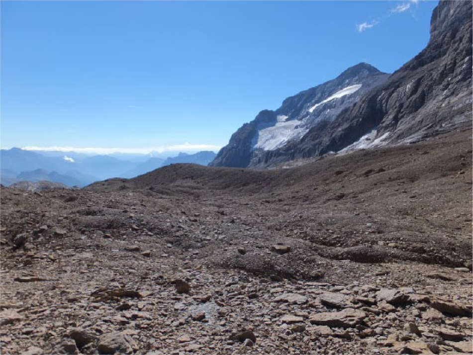
The large outer moraine and the Monte Perdido Peak, with small glaciers remaining at its wall.

The Monte Perdido Moraine (‘LIA’ Moraine), forming a large hill at the foot of the Monte Perdido Glacier. The foreground shows the chaotic accumulation of large limestone blocks and the outer Neoglacial moraine.
The morphology of the large moraine of the Monte Perdido Glacier indicates that a relatively important sediment remobilization occurred after its deposition. The existence of fluting transverse to the deposit indicates a rapid and recent glacial re-advance and the passage of ice over the moraine, leaving a thin layer of till. The dragging of blocks would have caused the development of furrows typical of fluted moraines (as pointed out by Martín Moreno, 2004). These furrows are also visible in the subglacial till deposited between the foot of the Monte Perdido wall and its moraine. Similarly, this advance would have deposited some small block-supported moraines.
A large accumulation of blocks without fine matrix forming several arcs and depressions caused by ice melting at the western end of the cirque is interpreted as a small, non-functional rock (or rock-covered) glacier developed.
Table 1 shows the grain-size distribution and carbonate contents of three glacial deposits: (1) the most external moraine, (2) a moraine at the foot of the Cilindro Peak and (3) the large moraine at the foot of the Monte Perdido Peak. Their mean carbonate contents are 30.2%, 35.8% and 86.6%, respectively. The grain-size distribution of the matrix also distinguished the Monte Perdido moraine, with a greater proportion of clay (37.3% vs 16.2% and 20.1% in the outer moraine and the Cilindro Peak moraine, respectively). The inner moraine of the Cilindro Peak contains a higher sand percentage. These local differences illustrate how Maastrichtien sandstone outcrops control the moraine compositions, as the Monte Perdido Moraine reflects the greater presence of limestone in the Monte Perdido Wall.
Grain-size distribution of the fine fraction in the moraines of the Marboré Cirque (%).

In the northern part of the Marboré Cirque, the Lake Glacier did not leave any moraine deposit, probably because it calved into the Marboré Lake; however, polished and striated surfaces are visible in the areas that were directly affected by this glacier. At the end of the 20th century, small snow patches persisted in this region.
Cosmogenic dating of the Marboré Cirque glacial landforms
Six dates were obtained from the Marboré Cirque, three from polished surfaces and three from boulders (Table 2). Two polished surfaces close to the small Lake glacier at the foot of the Astazu Peak yielded dates of 3.4 ± 0.2 and 2.5 ± 0.1 kyr (Figure 6), while another polished surface at the outlet of the Marboré Lake yielded a date of 1.2 ± 0.1 kyr. Two samples from large boulders located in the grey limestone deposit of the Balcón de Pineta yielded dates of 2.5 ± 0.05 and 4.4 ± 0.1 kyr, whereas a boulder located in the white limestone moraine (outermost moraine) at the front of the Monte Perdido glacier yielded an age of 5.1 ± 0.1 kyr.
36Cl exposure ages, sample type and sample location. Ages are reported for four assumed erosion rates (0, 1, 3 and 5 mm/kyr). Errors correspond to the analytical uncertainty of the AMS 36Cl determination (one standard deviation).

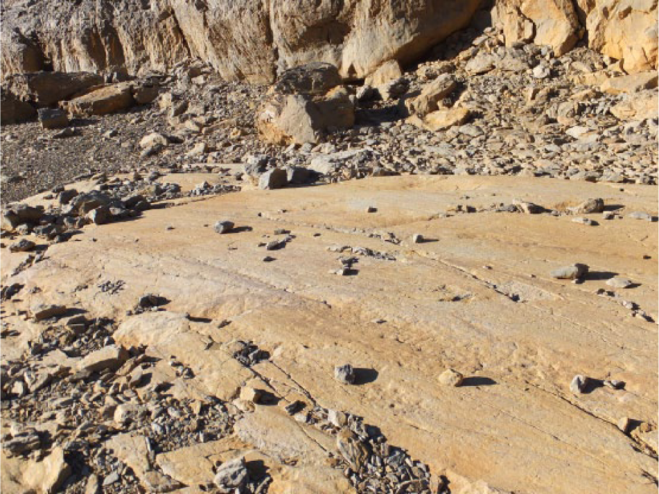
A polished surface sampled for cosmogenic dating of surface exposure near the former location of the Lake Glacier.
No other dates have been obtained from polished surfaces, moraines or other deposits of the Marboré Cirque, because weathering has intensively affected most of the deposits, and no adequate sites were found for sampling. The moraines behind the large outermost moraine undoubtedly belong to different stages of the ‘LIA’, given their fresh appearance and the absence of soil and vegetation. In fact, according to the map of Schrader from 1874 and other historical sources, the Monte Perdido Glacier made direct contact with the large moraine in the second half of the 19th century.
Discussion
The Marboré Cirque offers the best examples of Holocene glacial deposits in the Pyrenees and the Iberian Peninsula. No deposits corresponding to the Late Pleistocene have been found in the cirque, and there is sedimentological evidence that the Marboré Lake was deglaciated at least since the onset of the Holocene (Oliva-Urcia et al., 2013). The neighbouring La Larri Lake was dammed by a lateral moraine of the Cinca Glacier, which was probably related to the glacial advance phase at 39–32 kyr (Lewis et al., 2009). The lake filled up with sediment since >35 kyr until c. 11 kyr BP; when the moraine dam was breached, the lake was drained and incorporated to the fluvial network (Salazar-Rincón et al., 2013).
During the Holocene, the glaciers in the Marboré Cirque were confined to the southern half of the cirque, with ice masses associated with the large wall at the northern face of the Monte Perdido Massif (composed of the Monte Perdido, Cilindro and Marboré peaks). These glaciers undoubtedly experienced numerous spatial fluctuations (Figure 7), following patterns similar to those seen for other Holocene glaciers in mountain massifs of the world during the climate changes experienced since the beginning of the Holocene (e.g. Bakke et al., 2010; Camborieu Nebout et al., 2009; Clague et al., 2009; Davis et al., 2009; Deline and Orombelli, 2005; Mayewski et al., 2004; Menounos et al., 2009; Nesje, 2009; Wanner et al., 2011). Davis et al. (2009) concluded that many alpine glaciers disappeared during the Early Holocene, as temperatures warmed, particularly between 7 and 5.5 kyr (Holocene Thermal Optimum) (Geirsdóttir et al., 2013; Holzhauser et al., 2005; Renssen et al., 2012; Wanner et al., 2011). Many of such glaciers appeared again during the Neoglacial period (Davis et al., 2009; Geirsdóttir et al., 2013; Kelly and Lowell, 2009). In addition, the relatively large extent of the ‘LIA’ glaciers probably obscured most of the previous Holocene-era deposits (Deline and Orombelli, 2005). Figure 8 presents two geomorphic transects showing the relative positions of the glacial deposits and the rock avalanche, as well as the dates obtained from our analysis of cosmogenic exposure ages. The extents of the glaciers in the Mid Holocene and during the ‘LIA’ are also indicated. A general view of the Marboré Cirque is presented in Figure 9, showing the location of the ‘LIA’ glaciers, the rock avalanche and the Neoglacial moraine.
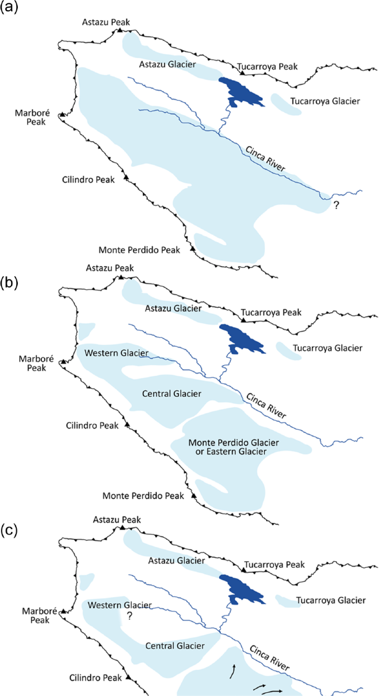
Evolution of glaciers in the Marboré Cirque during the Holocene: (a) Mid Holocene glaciers, (b) 17–18th century glaciers and (c) mid 19th century glaciers.
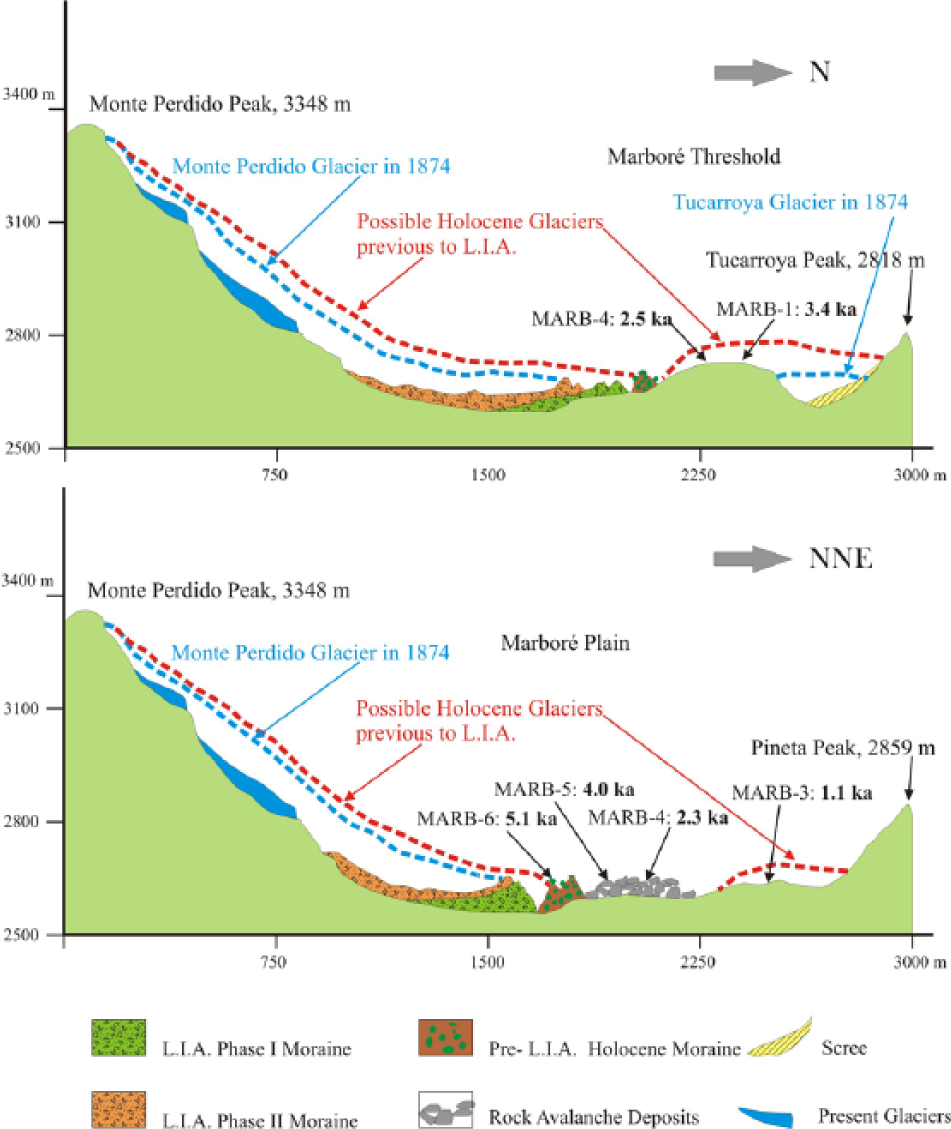
Geomorphic transects taken from the Marboré Cirque, showing the location of glaciers, tills and the Central Threshold. The locations and surface extent of the Holocene and ‘LIA’ glaciers are shown.
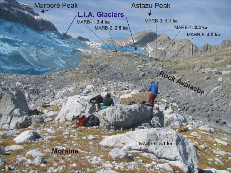
A general view towards the west of the Marboré Cirque, with the position and extent of the ‘LIA’ glaciers, the rock avalanche and, in the foreground, the Neoglacial, Mid Holocene Moraine.
Two of the deposits found in the Marboré Cirque, the rock avalanche and the outermost moraine, are related to processes that occurred before the ‘LIA’, according to our 36Cl dating. Although we have only a single boulder dated from the moraine (5.1 ± 0.1 kyr), this is the first Holocene date for glacial deposits in the Iberian Peninsula, apart from those of the ‘LIA’. Notably, radiocarbon ages from the Troumouse Cirque, located 9 km to the north on the French side of the Pyrenees, revealed an intensification of glacial activity between 5190 ± 90 and 4654 ± 60 yr BP (Gellatly et al., 1992), with glaciers larger than those developed during the ‘LIA’. This period coincides with the end of the relatively more humid and warmer conditions during the early Holocene to Mid Holocene and the onset of a trend towards more arid and (most probably) colder conditions around 5–4.5 kyr detected in the Marboré Lake (Oliva-Urcia et al., 2013) and a significant lake-level drop in other lakes in the Pyrenees after 5.7 cal. yr BP (Pérez-Sanz et al., 2013). In Sierra Nevada, southern Spain, this Mid Holocene cold period coincided with the development of solifluction landforms (Oliva and Gómez Ortiz, 2011). This era was also characterized by the development of rock glaciers in the Pyrenees (Serrano et al., 2011) and the Cantabrian Range of northern Spain (Pellitero et al., 2011).
This period of glacial advance has also been reported in many other mountain areas. For instance, Mayewski et al. (2004) stated that the most extensive of the so-called Holocene Rapid Climate Changes occurred from 6000 to 5000 yr BP. In the Alps, a generalized advance of the glaciers occurred during the period 5350–4900 yr BP in most regions (Deline and Orombelli, 2005; Denton and Karlén, 1973; Haas et al., 1998; Joerin et al., 2006; Wanner et al., 2011), with some exceptions (Ivy-Ochs et al., 2009a). Nesje (2009) reported several glacial advances in Scandinavia, including one at 5600–5300 yr BP. A short-lived cooling event was detected by Dormoy et al. (2009) in the Alboran and Aegean seas at 6.0–5.5 yr BP. A millennial-scale glacier advance was also identified in Western Canada by Clague et al. (2009) at 6.9–5.6 kyr, and by Maurer et al. (2012) at 5.4–4.9 kyr (the so-called Garibaldi Phase). Davis et al. (2009) confirmed that glaciers reformed and/or advanced in many regions of the world during the Neoglacial period, starting at approximately 6.5 kyr. In general, this cold period coincided with an arid phase in the Western Mediterranean (Jalut et al., 2000, 2009).
No evidence of older Holocene glacial activity has been found in the Marboré Cirque. The 8.2 Event (Alley and Agutsdottir, 2005) has been detected in some Pyrenean lake records (Pérez-Sanz et al., 2013), and it had remarkable consequences for human activity and settlements in some parts of the Mediterranean region (González-Sampériz et al., 2009). However, it was likely too short-lived to have large consequences on alpine glacier dynamics. Sediment cores from the Marboré Lake do not reflect any significant depositional change during the 8.2 Event (Oliva-Urcia et al., 2013).
The 36Cl age that we obtained for the outermost moraine appears to contradict the geomorphological evidence from other deposits and the dates obtained for polished bedrock using the same method (Table 3). This is the case for the avalanche of grey limestone boulders (2.5 ± 0.05 and 4.4 ± 0.1 kyr) located a bit further away from the Monte Perdido Wall, as well as the polished surfaces (3.4 ± 0.2 and 2.5 ± 0.1 kyr), located in the Central Threshold. This apparent contradiction may reflect technological limitations when using cosmogenic methods to date the exposure ages of limestone surfaces, which may be easily dissolved in a snowy environment. Nevertheless, 36Cl dating has been applied successfully to the limestone surfaces of archaeological remnants, when combined with adequate corrections for the snow cover and high dissolution rate (10 mm/kyr) (Ivy-Ochs et al., 2009b). The intense dissolution of limestone could potentially explain why we obtained more recent dates for the avalanche deposit than for the outermost moraine and could account for the dating differences between the two boulders sampled from the avalanche. However, even if we apply a dissolution rate of 20 mm/kyr, the dates would remain too recent, at 2.4 and 4.1 kyr. An alternative explanation is that the avalanche boulders underwent a rapid transport with fragmentation that facilitated subsequent erosion and weathering. In spite of these uncertainties, these minimal ages indicate that the avalanche occurred during the Holocene, prior to the ‘LIA’.
Field and analytical data for 36Cl samples from Marboré, Pyrenees.
The ages obtained from the polished bedrocks of the Central Threshold date the time when the ice retreated from these surfaces, but they are also difficult to integrate in the general glaciation framework for the Holocene. It is noteworthy that the glacial advances during Neoglaciation reflected periods of sudden, short climate change, and our dating method is not precise enough to distinguish the glaciation and deglaciation dates. However, the existence of clear glacial striations indicates that there was minimal post-glacial erosion, confirming that the deglaciation was a recent event. One possibility is that the polished bedrock was covered by other deposits, but we do not have any geomorphological evidence of such deposition. Another possibility is that these surfaces were covered by a glacier prior to the ‘LIA’. This possibility is more consistent with our observations, especially given that the Central Threshold was not, but almost fully glaciated during the ‘LIA’, when the ELA was located somewhat below 2700 m (i.e. slightly below the 2750-m summits of the Central Threshold). Thus, a glacial advance slightly more intense than that experienced during the ‘LIA’ would have developed a small icefield over the Central Threshold during this period (3.5–2.5 kyr).
If we accept the above hypothesis, the ages obtained for the surface-polished bedrock of the Central Threshold indicate that a glacier retreated between 3.4 ± 0.2 and 2.5 ± 0.1 kyr coinciding with the Bronze–Iron Ages. This coincides with the end of one of the most important glacial advances of the Neoglacial period, at 3.5–2.3 kyr (Davis et al., 2009; Mayewski et al., 2004; Wanner et al., 2008, 2011). This advance could have glaciated the summit of the Central Threshold, where the two sampling sites were located. Consistent with this, important glacial advances around 3.5–3.2 and 2.6–2.4 kyr have been detected in the Alps (Deline and Orombelli, 2005; Haas et al., 1998; Holzhauser et al., 2005; Ivy-Ochs et al., 2009a; Joerin et al., 2006), Scandinavia (Bakke et al., 2010; Nesje, 2009), Iceland (Geirsdóttir et al., 2013; Larsen et al., 2012), the Altai Mountains (Chernykh et al., 2013), West Greenland (Levy et al., 2013), West Canada (Tiedemann-Peyto Advance) (Clague et al., 2009; Maurer et al., 2012; Menounos et al., 2009) and the Sierra Nevada of California (Bowerman and Clark, 2011). This is typically considered a period of minimum glaciation (Holzhauser et al., 2005) because of increasing aridity in the Pyrenees (Pérez-Sanz et al., 2013), the Iberian Peninsula (Martín-Puertas et al., 2008) and the Western Mediterranean in general (Nieto-Moreno et al., 2011). However, more humid conditions have been found in some other areas (Corella et al., 2011; Menounos et al., 2009; Moreno et al., 2011). For example, the sedimentary record from the Laguna de la Mosca in Sierra Nevada (southern Spain) indicates that a glacier was present at the northern face of the Mulhacén Peak between 2.8 and 2.7 kyr BP (Oliva and Gómez Ortiz, 2012).
Another polished surface was also dated in a small depression of the Central Threshold (1.2 ± 0.1 kyr), suggesting the presence of a glacier during the generalized glacial expansion that took place between 1.4 and 1.2 kyr (Dark Age Cold Period) in Europe and North America (Bakke et al., 2010; Chernykh et al., 2013; Davis et al., 2009; Geirsdóttir et al., 2013; Larsen et al., 2012; Levy et al., 2013; Lowell et al., 2013; Maurer et al., 2012; Mayewski et al., 2004; Menounos et al., 2009; Nesje, 2009; Wanner et al., 2008, 2011). The glaciation of this phase equalled (Haas et al., 1998; Ivy-Ochs et al., 2009a), and in some cases surpassed (Deline and Orombelli, 2005; Holzhauser et al., 2005), the ‘LIA’ glacier advance in some areas of the Alps. Furthermore, glaciation re-appeared on the northern slope of Mulhacén Peak (Sierra Nevada, southern Spain) between 1.4 and 1.2 kyr BP (Oliva and Gómez Ortiz, 2012). The age of this polished surface indicates that during the Medieval Climatic Anomaly (MCA, 1.15–0.65 cal. kyr BP), deglaciation occurred at the high altitudes in the Pyrenees. The MCA was warmer and relatively more arid period in the Iberian Peninsula as indicated by lacustrine records from NE Spain (Corella et al., 2012, 2013; Morellón et al., 2012), and southern Spain (Zoñar and La Moska lakes: Martín-Puertas et al., 2008; Oliva and Gómez Ortiz, 2012), marine sediment near the Alboran basin (Martín-Puertas et al., 2010; Nieto-Moreno et al., 2011), and fossil pollen data from southern France to southeast Spain (Jalut et al., 2000). According to Moreno et al. (2012), the MCA in the Iberian Peninsula was characterized by decreased lake levels, fewer floods, major Saharan aeolian fluxes and less fluvial input to marine basins.
A new and far-reaching glacial re-advance occurred during the ‘LIA’ (Figure 7), a period of relatively colder and more humid conditions in the Iberian Peninsula, but with large climate variability (Morellón et al., 2012). Numerous fluctuations in the sizes of the ice masses in the Marboré Cirque demonstrate that the glaciers expanded and contracted following small climate changes. During the ‘LIA’ maximum extent, the glaciers almost fully contacted with the Mid Holocene outermost moraine. The ‘LIA’ moraines are very well defined, with acute ridges composed of blocks embedded in a massive fine matrix. The largest of these moraines developed at the foot of the Monte Perdido Peak, resulting in a frontal–lateral deposit that extended to the east. Later, a retreat followed by a new (probably short-lived) expansion caused a re-advance during which the ice mass covered the previous moraines, leaving deposits in the form of fluted moraines (González Trueba et al., 2008; Martín Moreno, 2004). Since then, the region has experienced intense deglaciation, particularly in the middle of the 19th century and the end of the 20th century: the Western and Central glaciers have melted, and the Monte Perdido Glacier has become an increasingly thin ice mass. Until the middle of the 20th century, the Monte Perdido Glacier consisted of three stepped ice masses. The lowest one, which was supported by snow and ice avalanches from the intermediate glacier, had already melted in the late 1970s. The other two ice masses have been in a rapid regressive stage since the 1980s, decreasing in both area and (especially) thickness. The intermediate glacier formed an abrupt ice cliff that produced frequent ice avalanches. It had a bevelled ice front that lost up to 40 m in thickness between 1981 and 1999 (Julián and Chueca, 2007) (Figure 10). According to Chueca and Julián (2010, published in 2011) and considering the location of the ‘LIA’ moraines, the glaciers of the Marboré Cirque occupied 239 ha at the end of the ‘LIA’, 62.1 ha in 1999 and only 49.2 ha in 2011.
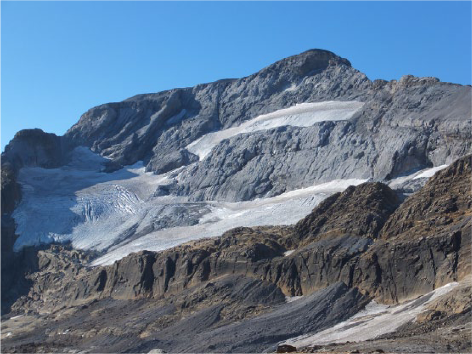
The Upper and Middle (now Lower) Monte Perdido glaciers, showing the bevelled ice surface. The ice masses are located on structural perched flats of the northern face of the Monte Perdido Peak.
In the Lake Glacier, deglaciation caused the rapid development of gelifraction, solifluction and nivation processes, leading to the disappearance of glacial landforms under a series of debris cones. Patterned ground also developed in small flat areas, mainly in the eastern sector of the Marboré Lake and in some platforms of the Central Threshold, close to the western end of the cirque (Boyé, 1952a). Other glaciers have also disappeared over the last few decades, including those in the southern versant of the Monte Perdido Massif (i.e. Soum de Ramond, Southwest Cilindro and South Taillón) and other Pyrenean massifs (Chueca et al., 2002).
González Trueba et al. (2008) confirmed that the maximum ‘LIA’ glacier advance occurred at the end of the 17th or the beginning of the 18th centuries, coinciding with the Maunder Minimum (a period of low sunspot activity,
Another significant advance may have occurred during the Dalton Minimum (
Although generalized glacial retreat started after this phase in the Pyrenees, some Pyrenean glaciers experienced a minor re-advance during a short cooling period between 1880 and 1910 (Saz and Creus, 2001). Since the turn of the 20th century, the mean temperature in the southern Pyrenees has increased between 0.85°C and 1°C, as estimated by Chueca et al. (1998), López-Moreno (2000) and González Trueba et al. (2008). Glacial retreat of the 20th century has affected all of the Pyrenean glaciers (Chueca Cía et al., 2005; Gellatly et al., 1994; López-Moreno, 2000), as well as those in the Sierra Nevada, southern Spain (Gómez Ortiz et al., 2004) and the Cantabrian Range (González Trueba et al., 2008). Strong and rapid glacial retreats in response to climate warming have also been reported throughout the Alps, particularly in the case of small glaciers (Diolaiuti et al., 2011). Chueca Cía et al. (2005) demonstrated that the retreat of the Pyrenean glaciers is related to increases in annual temperatures and decreases in winter precipitation, and not to summer temperature or the annual precipitation. It is also noteworthy that the late-spring snow accumulation in the Pyrenees has shown a significant negative trend since the mid 20th century, because of a progressive decline in winter precipitation (López-Moreno, 2005).
Conclusion
The Marboré Cirque contains the best examples of Holocene glacial deposits in the Iberian Peninsula. A detailed geomorphological survey of the different deposits and new cosmogenic dates on surface exposure allow us to reconstruct the Holocene glacial evolution with the following phases:
Deglaciation of most of the Marboré Cirque occurred before 12.7 cal. kyr BP.
There is no evidence of glacial activity during the Early Holocene. It is highly probable that some ice masses persisted at the foot of the northern face of the Monte Perdido Massif, but their moraines have been obscured by subsequent glacial advances. Thus, as seen for many other mountains worldwide, the early Holocene glaciers in this region were much smaller than those of the Mid Holocene or ‘LIA’.
A glacial expansion occurred during the Mid Holocene (5.1 ± 0.1 kyr BP), and a large continuous push moraine was generated by a unique ice mass at the foot of the Monte Perdido Massif.
A large rock avalanche occurred during the Mid Holocene, affecting the northern face of the Monte Perdido Peak and leaving a chaotic deposit of large grey limestone blocks. This avalanche has not yet been related to any environmental event.
The surface-exposure ages of approximately 3.4 ± 0.2 and 2.5 ± 0.1 kyr BP shows a glacial retreat synchronous with the Bronze/Iron Ages, following one of the most important glacial advances of the Neoglacial period.
A melting period occurred during the MCA (c. 1.2 ± 0.1 kyr) after a small glacial expansion during the Dark Age Cold Period (1.4–1.2 kyr).
The ‘LIA’ represented a clear stage of glacial expansion, with independent ice masses expanding from the bases of the Monte Perdido, Cilindro and Marboré peaks. Two different pulses were separated by a short retraction. The first (more extended) pulse most likely occurred at the end of the 17th century or the beginning of the 18th century (Maunder Minimum), whereas the second, which appears to have occurred between 1790 and 1830 (Dalton Minimum), was a rapid glacial advance that left only thin deposits as fluted moraines. Since then, glaciers have been receding rapidly, particularly during the second half of the 20th century.
Footnotes
Funding
This work was supported by HORDA (ref: 83/2009), funded by the Organismo Autónomo de Parques Nacionales, and by INDICA (CGL2011-27753-C02-01 and -02) and CGL2012-35858, funded by the Spanish Ministry of Economy and Competitiveness. Financial support for the Research Group on Geomorphology and Global Change was provided by the Aragón Government and the European Social Fund (ESF-FSE).