
Abstract
Although archaeological analysis emphasizes the importance of climatic events as a driver of historical processes, we use a variety of environmental and archaeological data to show that human modification of the environment was a significant factor in shaping the early history of the Yellow River region of North China. Humans began to modify site-specific and local-level environments in the Early Holocene (~11,500–7000 BP). By the Mid-Holocene (~7000–5000 BP), the effects of humans on the environment become much larger and are witnessed at regional and tributary river basin scales. Land clearance and agriculture, as well as related land use, are dominant determinants of these changes. By the Late Neolithic to Early Bronze Age (~5000–3500 BP), population growth and intensification of agricultural production expanded the human footprint across the Yellow River region. By the Mid to Late Bronze Age (~3600–2200 BP), larger populations armed with better technology and propelled by more centralized governments were altering lands throughout the Yellow River region, gradually bringing the environment under human control. By the Early Dynastic period (221
Introduction
Background
This paper reviews evidence indicating how human activity in ancient China during the Holocene contributed to large-scale environmental changes and what the consequences of these changes were. Modern China is developing economically at a stunning pace, and it is not clear whether this rate of change is environmentally sustainable. Many of the climatic and environmental issues facing contemporary China, however, have been experienced in the past – albeit at a different scale – and it is instructive to understand how ancient Chinese societies as an example grappled with these issues and which approaches and strategies have been successful and which have failed (Ellis et al., 2013a, 2013b).
Traditional archaeological analysis emphasizes the importance of climatic events as a driver of historical processes (Catto and Catto, 2004; DeMenocal, 2001; Issar and Zohar, 2007; Kennett et al., 2012; Kennett and Kennett, 2006; Leroy, 2006; Middleton, 2012: 268–270; Weiss, 1997; Weiss and Bradley, 2001; Wright, 1993; Wright and Thorpe, 2003). We use a variety of environmental and archaeological data from China to show a more complex state of affairs. Humans started modifying site-specific and local-level environments in the Early Holocene (~11,500–7000 BP
1
). By the Mid-Holocene (~7000–5000 BP), the effects of humans on the environment become much larger and are witnessed at regional and tributary river basin scales. Land clearance and agriculture, as well as related land use, are dominant drivers of these changes. By the Late Neolithic to Early Bronze Age (~5000–3500 BP), population growth and increasing intensification of agricultural production expanded the human footprint across the Yellow River region. By the Mid to Late Bronze Age (~3600–2200 BP), larger populations armed with better technology and propelled by more centralized governments were altering lands throughout the Yellow River region, gradually bringing the environment under human control. By the Early Dynastic period (221
Anthropocene as a research agenda
The Anthropocene has become an increasingly important concept in modern scientific discourse. Popularized by Crutzen and colleagues (Crutzen, 2002; Crutzen and Steffen, 2003; Crutzen and Stoermer, 2000; Price et al., 2011; Steffen et al., 2007, 2011; Zalasiewicz et al., 2008, 2010, 2011), the term denotes increasing human alteration of earth and atmospheric systems since roughly
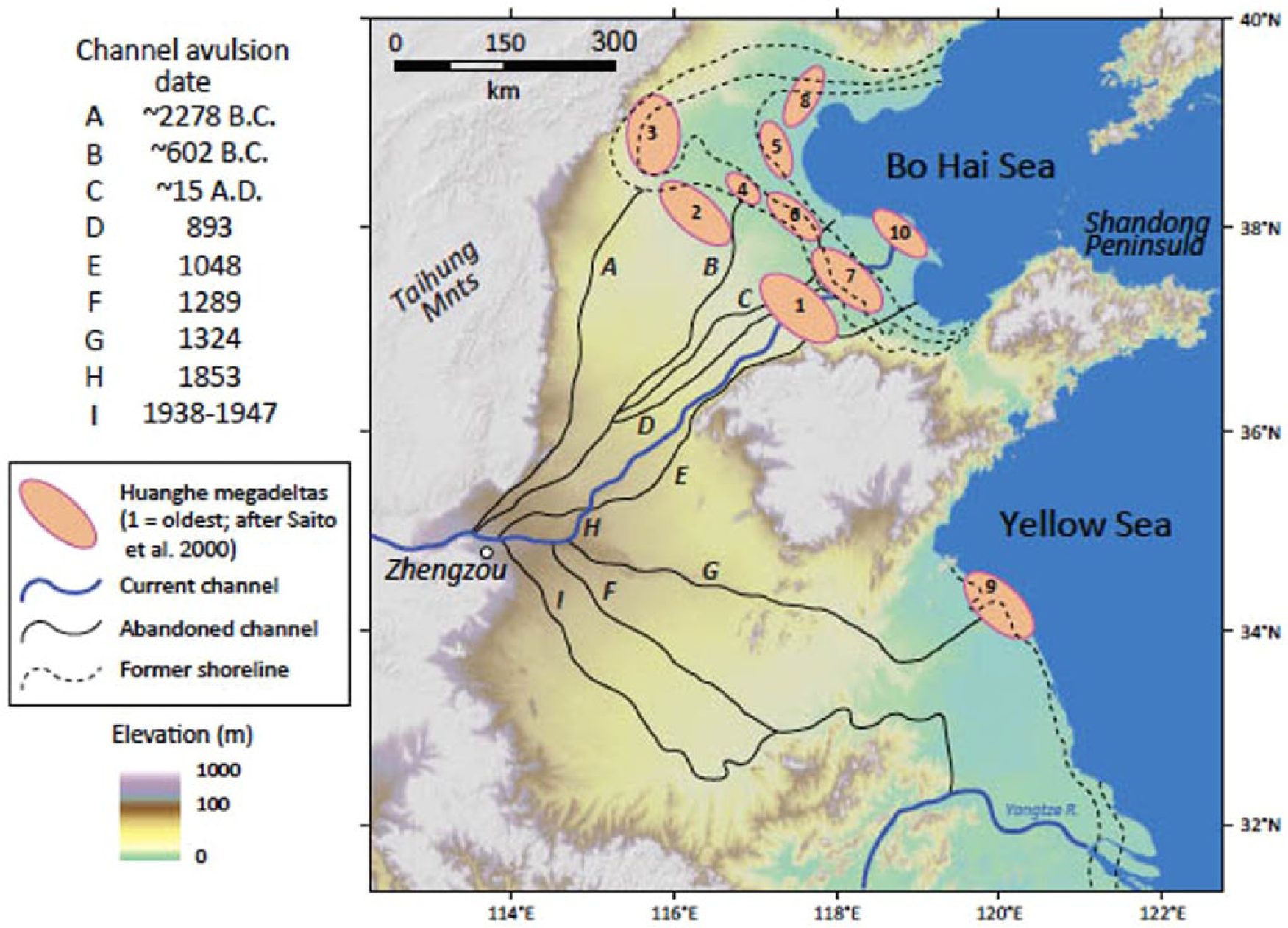
Location of the Yellow River and the Chinese Loess Plateau. Inset A shows the generalized LYR avulsion history of the past 4000 years (imaging courtesy of Mike Lamb, California Institute of Technology).
Ruddiman argues that humans transformed global environments as early as ~7000 BP and possibly earlier (Ruddiman, 2003, 2005a, 2005b, 2013; Ruddiman et al., 2011; Ruddiman and Thomson, 2001). He notes that CH4 and CO2 levels as measured in polar ice sheets have been increasing since the Early to Middle Holocene in contrast to expectations that they should be declining as a consequence of decreasing insolation associated with changing orbital parameters. He asserts that these trends must be the consequence of human transformations of environments, most notably cutting forests, burning wood and other fuels, and the development of agriculture (Boyle et al., 2011; Certini and Scalenghe, 2011; Fuller et al., 2011; Giosan et al., 2012b; Kaplan et al., 2009; Li et al., 2009a; Ruddiman and Ellis, 2009). These findings are controversial, and the ‘Early Anthropocene’ concept remains a hypothesis to be tested. A major objection to this hypothesis is the notion that pre-modern humans using relatively low-intensity technology and with relatively small populations at low density could undertake forest clearance, agriculture, and industrial production at levels sufficient to alter global atmospheric chemistry. However, even if early human societies did not alter atmospheric chemistry, recent research suggests there is a large and surprisingly early anthropogenic footprint in a variety of locations around the globe (Ellis et al., 2013a: Figure 1; Redman, 1999; Wilkinson, 2010). A thorough re-examination of these environmental and archaeological data is thus an urgent task to better conceptualize Early Anthropocene as a global research agenda.
Data we use
We use proxy data on the following aspects: geochemical/physical properties of soil/sediment sequences, vegetation changes reflected in floral remains, and variations of charcoal concentration from archaeological and environmental record.
Soils and sediments present the most immediate evidence of human intervention in natural systems. The most crucial modification in this regard is the creation of various anthropogenically modified soils for agricultural and horticultural purposes, which are termed anthrosols (e.g. plaggen soils, terrace field soils, and terra preta do índio in the Amazon; see section ‘Soil modification and soil loss’). Soils formed in urban environments would also be included in this definition. Although soil formation and sediment deposition are usually localized processes, human-modified soils and sediments are widely present in the Yellow River from the Late Neolithic onward, making them ideal material to trace human impacts.
Floral data are our second line of evidence. Abundant data on micro-plant (palynological and phytolith) and macro-plant remains have accumulated in the past decades in China. While issues concerning pollen grains and long-distance transportation of some arboreal pollens and thus scales for which pollen should be used for environmental reconstructions are subject to continuing debate (Dimbleby, 1984; Li, 1998; Yu et al., 2004), these data provide detailed evidence for the long-term interplay between people, plants, and landscape change at both site and regional scales.
Analysis of charcoal as a proxy indicator of burning and land clearance and its implications for landscape changes are ongoing (Lancelotti, 2010; Lancelotti et al., 2010; Marlon et al., 2008, 2013; Whelan, 1995). Interpretation of the correlation between charcoal concentrations and human activities should thus be supplemented by other lines of evidence. However, charcoal records often reveal tendencies parallel with those reflected by floral evidence of increasing human impact on landscape through time (Huang et al., 2006b).
Although reliable, high-resolution chronologies enabling a robust integration of archaeological data with environmental data are not yet complete, archaeological research on settlement patterns, social developments, and technological advancement offers a comparable perspective on increasing human management of physical environments from the Neolithic to Early Dynastic time. Reassessment of available archaeological data results in a more complex understanding of human–environment interaction than previously considered.
Yellow River, Loess Plateau, and Asian monsoons
The Yellow River was crucial to the development of China’s Neolithic and historic cultures by providing resources essential for long-term economic sustainability. It provides water for irrigation, transportation, and consumption; it regularly floods and replenishes soil with rich nutrients; and riverine wetlands that formed near the Yellow River channel and its tributaries are places with rich natural plant and animal resources.
However, beneficial as the Yellow River has been, it is also regarded as ‘China’s tribulation’ (Wu and Ge, 2005) because of frequent natural disasters afflicting the inhabitants of the floodplain. Mainly because of its heavily silt-laden water (from which its name is derived), tectonic activities, and concentrated summer monsoonal rainfall, the Yellow River channel, particularly the section in its lower reach, frequently changes its course in centennial scales (Chen et al., 2012; Qinghai et al., 1996a, 1996b). This has fundamentally affected the shaping of the alluvial landscape along the Yellow River. In the later part of the Holocene, the water is further muddied by intensified human activities. Yellow River floods and frequent river avulsions play a decisive role in economic and political developments (Figure 1).
In its upper and middle reaches, the Yellow River flows through the Chinese Loess Plateau (CLP) (Figures 1 and 2; Liu, 1985). Loess is well suited for agricultural production (Catt, 2001; Connor et al., 2011; Ho, 1969; Pulleman, 2002). However, like the Yellow River, these conditions are a double-edged sword. The silt-sized soil skeleton of loess promotes deep penetration of sub-ground water (Zhang and An, 1994; Zhao, 2002); in most regions of the CLP, such a hydrological condition can only support grass growth (Li et al., 2003a, 2003b). Sparse vegetation cover and the loose soil structure of loess result in continuous surface erosion and gullying, particularly when it is combined with human intervention under dry climatic conditions.
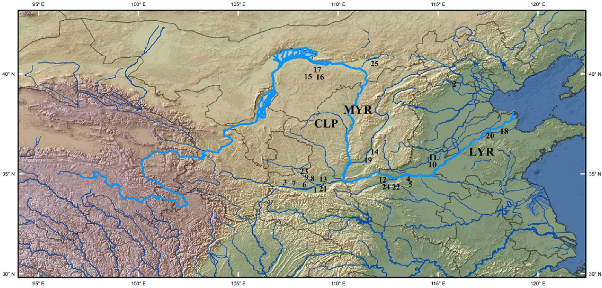
Topographic map of North China and the Yellow River (map data from the United States Geological Survey 3 Arc Second Shuttle Radar Topography Mission data set (http://www.glcf.umd.edu/data/srtm/). 1: Guobei; 2: Beifudi; 3: Dadiwan; 4. Xishan; 5: Dahecun; 6: Xindian; 7: Guantaoyuan; 8: Chengjiachuan; 9: Qishuihe River; 10: Sanyangzhuang; 11: Anshang; 12: Zaojiaoshu; 13: Yangguanzhai; 14: Taosi; 15: Mu Us Desert; 16: Dabaodang; 17: Ordos; 18: Tonglin; 19: Sushui River; 20: Yuezhuang; 21: Jiangzhai; 22: Wadian; 23: Majiayuan; 24: Yiluo valley; 25: Daihai lake.
The Holocene history of the East Asian monsoon is an alteration between strong and weak monsoon periods. These periods are generally controlled by orbital forcing and its effects on the inter-tropical convergence zone. During strong monsoon periods, moisture is brought farther into the continental interior (notably, in this case, the CLP; in Yellow River catchments, 70% of annual precipitation is concentrated in the summer). During weak periods, the monsoon boundary retreats south and east, resulting in less moisture reaching the interior (An et al., 2000; Cai et al., 2010; Clift and Plumb, 2008; Cook et al., 2010; Cosford et al., 2008; Maher, 2008; Selvaraj et al., 2007; Tan et al., 2009, 2010; Yancheva et al., 2007). These general trends are punctuated by years of abnormal weakened summer monsoons associated with El Niño episodes. These short-term climatic events cause rainfall anomalies (Wen et al., 2000). Strong El Niño events result in extreme aridity in central China. When the monsoon strengthens again, it brings rain to the arid landscape, which causes significant erosion because there is less vegetation and a higher runoff rate. Thus, the paradox of drought is excessive flooding and erosion that impose severe flood risks on rivers.
Early Neolithic (8000–7000 BP): Early development of agriculture
Climate, settlement, and early development of agriculture
The Early Holocene in many parts of North China experienced steady climatic improvement (An et al., 1991; Cosford et al., 2008; Dong et al., 2010; Dykoski et al., 2005; Morrill et al., 2003; Wu et al., 2012; Xia et al., 1998; Zhai et al., 2011; Zhang et al., 2011; Zhu et al., 2001) as insolation increased and the East Asian monsoon system strengthened. A general pattern of climatic improvement – the so-called Holocene Optimum (HO) – spans part of this period, although this climatic amelioration was spatially and temporally quite variable (An et al., 2000; Stevens and Lu, 2010; Wang et al., 2010; more discussion in next section).
Early Neolithic sites are concentrated in the Wei River of the Western and Southern CLP and tributaries of the Middle Yellow River (State Administration of Cultural Heritage, 1991, 1998, 2006, 2007; Zhang, 2007); lowlands, such as river floodplains and footslopes, were the primary choice for settlements.
The Early Neolithic is a critical period of increasing landscape management; domestication of plants and animals was underway, but subsistence practices were still very diverse (cf. Colledge et al., 2004; Fuller et al., 2007, 2009; Piperno, 2011; Zeder, 2006). In addition, larger populations are associated with more houses and buildings, more investment in pottery and other tool production, and larger numbers of cemetery burials. While the scale of these transformations is small relative to more recent times, taken together, footprints of human activities are now traceable, marking the beginning of a new type of relationship between people and the environment.
Soil and charcoal evidence from the Southern CLP
Ecological impacts of these activities have been observed in regions along the tributaries of the Yellow River. At Guobei (Figure 2-1), Early Neolithic land use revealed by soil micromorphology and particle size distribution is characterized by scattered farming activities and occasional use of fire; the natural grass and woodland cover remained largely undisturbed. The immediate consequence of such diversified land use on soils is the creation of diagnostic pedo-features, such as surface crusts and subsequent breaking down of these soil aggregates, and ‘dirty’ soil groundmass rich in organic matter and charcoal (Zhuang, 2012; Figure 3).
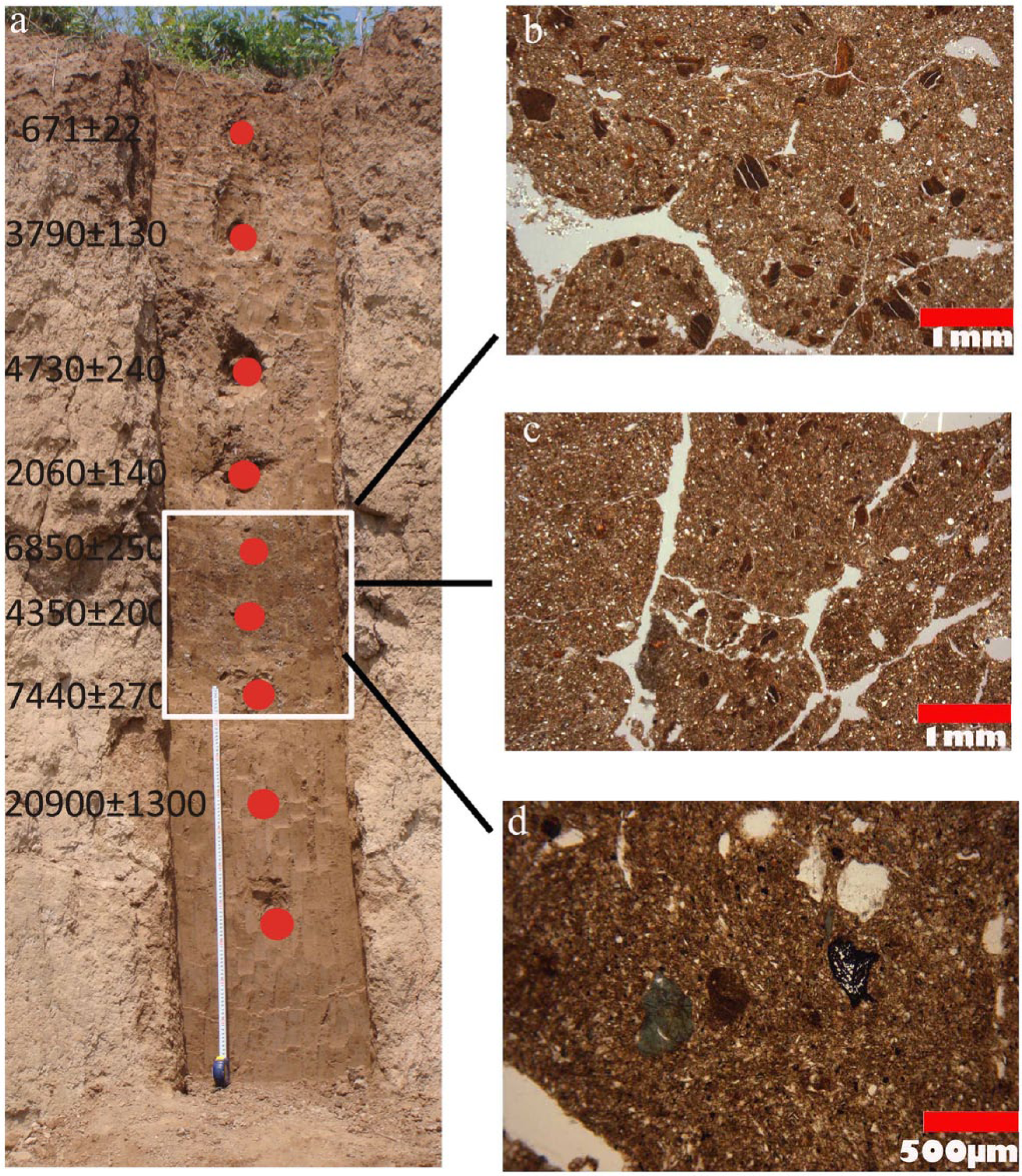
Stratigraphy and micro-photos at Guobei: (a) Stratigraphy and OSL dates, note the date reverses and the gap between the Early-Holocene palaeosol (rectangular box) and the underlying Late-Pleistocene deposits; (b) and (c) disrupted clay textural pedo-features probably because of physical disturbance; and (d) coarse fraction in the organic-rich groundmass.
Evidence of similar soil features altered by farming-related disturbance is found in other reports (Huang et al., 2002, 2006a; Pang et al., 2007a; Xiubin et al., 2002), indicating that comparable farming methods were practiced during this time.
The earliest crops in this area were millets, which even after domestication have weedy characteristics (Dekker, 2003). Although these weedy characteristics do not necessarily point to swidden or slash-and-burn farming, deliberate firing may have been necessary to deal with this problem and for other activities (e.g. hunting on river floodplains, cf. Mellars and Dark, 1998). This hypothesis is supported by increasing evidence from both charcoal and pollen analyses. There is a correlation between peaks of micro-charcoal remains and the onset of Early Neolithic agriculture. Tan et al. (2011) examine charcoal of variable sizes collected from two sites (Figure 2-23) located in the uplands and lowlands of the Southern CLP. The pre-agricultural landscape is characterized by typical steppe-type herbaceous plants (Li et al., 2003a; Lu et al., 2003), and wildfire was frequent under a dry–cold climate. The latter is indicated by the presence of micro-charcoal derived from wind-blown transportation. From 7500 BP onward, periodic concentrations of large-sized charcoal (>50 µm), well-rounded spherical pellets, and elevated total organic carbon correspond to the expansion of Neolithic farming communities and the ‘initial clearance of forest for arable farming’ (Huang et al., 2002, 2003b; Lu and Zhang, 2008; Tan et al., 2011). Meanwhile, the quantity of small-sized charcoal dramatically decreases, implying less frequent wildfires. Fire contributes to the shaping of the shrub steppe vegetation on upland hills and open, sparse forest–grasslands in lowland areas of this region from the Early Holocene onward.
Pollen and soil evidence from other regions
In other regions, changing vegetation patterns as a consequence of initial farming and related activities are registered in pollen records at archaeological sites. For example, at Beifudi (Figure 2-2), there was a transition in vegetation from open woodland to grassland–woodland although clear archaeobotanical evidence of agriculture is still absent (Duan, 2007; Yuecong et al., 2011). This shift is marked by the presence of pollen grains of ‘planted cereals’ (Yuecong et al., 2011) that have long axes measuring 35–45 µm, implying domestication and thus farming activities in the vicinity.
After a protracted period of soil formation in the hillslopes adjacent to the Yiluo valley (Figure 2-24) of the southeastern CLP, Rosen observed ‘an abrupt shift to high-energy channel activities’ shown by ‘a massive buildup of gravels’ derived from significant soil erosion and gullying in the upper catchment, beginning around 7200 BP (Rosen, 2008: 305).
In the LYR, most Early Neolithic sites are situated close to river floodplains. At Yuezhuang (Figure 2-20), human effects are manifested by the formation of pedo-features such as surface crusts, dusty clay coatings, and anthropogenic inclusions such as pottery sherds and bone fragments, suggesting surface sheetwash by cultural activities nearby (Zhuang et al., 2013). However, the impact of these activities is minor.
Middle Neolithic (7000–5000 BP): Beginning of population expansion and intensified land use
Climate and cultural development
Middle Neolithic cultural developments coincide with the onset of climatic amelioration (Shi and Kong, 1992). Improving climates evolved asynchronously across different regions in China and exhibit temporal and spatial variations in temperature and precipitation (An et al., 2000; He et al., 2004; Stevens and Lu, 2010; Wang et al., 2010). Most parts of North China reached the peak of higher temperatures and precipitation between 7000 and 5000 BP. However, climatic fluctuations noted in some records are characterized by short periods of increasing aridity, which potentially could have an effect on cultural development (Huang et al., 2000).
This period saw a dramatic increase in both the number (Wagner et al., 2013: Figure 4) and size of settlements; these communities are found over a much wider geographic area, and many exhibit long occupation histories (lasting in some instances for almost 2000 years). Excavations at many large settlements reveal houses with similar structural types and orientations, associated facilities for craft production or other economic activities, and surrounding moats, with cemeteries inside or outside the moats (Institute of Archaeology and Cultural Relics, 2001; Institute of Archaeology, Chinese Academy of Social Science, 1963; Museum of Xi’an Banpo (MXB) and Shaanxi Provincial Institute of Archaeology (SPIA), 1988). The development of wood and earth building methods enabled construction of large-sized, above-ground houses and long houses (Institute of Archaeology and Cultural Relics, 2001; PIACRG, 2006; Zhang et al., 2000). At Jiangzhai (Figure 2-21), for example, 60% of houses have walls made of wood and earth. Large amounts of wood would have been used for such constructions (Zhang, 2010: 87–88) as well as for firing of huge numbers of painted pots. The production of numerous stone tools (Gong, 2002: Chapter 5) for field clearance, digging, and food processing is another proxy measure of increasing human manipulation of the environment.
Stratigraphy and modern land use at Guantaoyuan: (a) arrow points to Middle-Holocene-eroded deposits and (b) erosion gully, heavily silt-laden water, and modern land use.
Increasing landscape modification is also demonstrated by the diverse economy at this time. Phytolith and archaeobotanical evidence suggests that with improved water conditions associated with the HO, Yangshao people began to cultivate rice on river floodplains in many parts of the CLP while continuing to grow millets in dry lands (Liu et al., 2008; Lu and Zhang, 2008; Zhang, 2000; Zhang et al., 2010a). The importance of animal husbandry for this period is confirmed by zooarchaeological and isotopic research (Wang, 2011; Yuan, 1999; Yuan and Flad, 2002; Zhang et al., 2010b); however, hunting was still important (cf. Shaanxi Provincial Institute of Archaeology (SPIA) and Archaeological Team of Baoji City (ATBC), 2007; Yuan et al., 2008). These diversified economic practices enabled more robust adaptations to diversified environmental conditions and improved ability to cope with short-term climatic variations under a new wave of migration. Consequently, the Yangshao people exerted more evident impact on the environment.
Vegetation changes
At Dadiwan (Figure 2-3), there is a significant drop in arboreal and shrubby plant pollen between 6000 and 5000 BP, while pollen and phytoliths of semi-arid herbaceous species (e.g. Artemisia) greatly increase; these changes are coupled with a growing abundance of charcoal (Liu et al., 2004a). Because there is no evidence of obvious climatic variation that would cause these vegetation changes, these deviations are attributed to deforestation when population increased. The same pattern is observed in the pollen assemblage at Xishan (Figure 2-4; 7300–5400 BP) and other Late Yangshao sites in the CLP (Wang et al., 2004; Zhang, 2010: 24). At Xishan, in addition to Artemisia being dominant, Chenopodiaceae and Gramineae pollens are also abundant. Large-sized cereal pollen grains, usually of Gramineae family, are identified at Dahecun (Figure 2-5; c. 6000–5000 BP, but exact chronological and sedimentary contexts are not provided; Institute of Archaeology and Cultural Relics, 2001: 675–680) and Xindian (Figure 2-6; 7700–5500 BP, Li et al., 2009b). More indications of anthropogenic influences are noted in accumulating palynological records from this time (Li et al., 2003b; Xiubin et al., 2004; and references in Rosen, 2008).
The use of fire
In many charcoal records, the >50-µm fraction (Huang et al., 2006b; Tan et al., 2011) increases at ~6000–5500 BP and coincides with high magnetic susceptibility in bulk samples (Huang et al., 2006b). Under warm/humid climatic conditions that significantly reduce wildfire frequency (Marlon et al., 2013), these trends, along with appearance of cereal pollens, point to intensified farming, greater land use, and increased environmental effects. The results of the charcoal record in the Daihai lake region (Figure 2-25) near the Middle Yellow River (MYR) are particularly interesting in this instance. Peaks in micro-charcoal concentration during 7000–5000 BP are presumably the result of agricultural activities by Yangshao migrants (Wang et al., 2013).
Soil evidence
The HO encouraged strong pedogenic development facilitated by improved hydrological conditions and vegetation cover (Pang et al., 2007b; Xiubin et al., 2004). In addition, growing evidence suggests human intervention in pedogenic processes. First, heterogeneous materials, such as pottery sherds, charcoal, and possibly night soils, were often incorporated into soils (Huang et al., 2000). Second, anthropogenic amendment may be the cause of elevated organic matter and total organic carbon in bulk samples. Third, ‘well-rounded spherical pellets’, a typical soil structure resulting from cultivation, are more common than before (Huang et al., 2002; Pang et al., 2006, 2007a). Last, some suggest that long-term cultivation may have also led to the loss of soil fertility as revealed by changes in C/N ratios (Wang et al., 2004), a typical criterion used in modern agronomic sciences (Li, 2008). It is hard, however, to assess the long-term effect of cultivation before systematic studies are done, as these agricultural practices may have been counteracted through, for example, manuring.
Often, Yangshao house floors cut directly into truncated Early-/Mid-Holocene soils (Rosen, 2008; Zhang et al., 2000). They were then leveled with fill before red colored mud-plastered floors were applied over single or multiple quarried slabs of fossiliferous tabular tufa (MacPhail and Crowther, 2007). Such houses are commonly discovered throughout the Yellow River and tributary basins, and the construction of them must have involved large-scale ‘soil stripping’ (Rosen, 2008). At Guantaoyuan (Figure 2-7), for instance, Pre-Yangshao and Yangshao settlements (SPIA and ATBC, 2007) are constructed on the hillslope. Field survey has located colluvium containing abundant eroded aggregates at the footslope position overlying the Early-Holocene soil/sediment. They are thus likely of Middle-Holocene age, resulting from erosion from upper slope areas (Figure 4).
Late Neolithic (5000–4000 BP): The onset of an Early Chinese ‘Great Acceleration’
Climate, economic achievement, and agricultural development
The latter part of the Holocene experienced increasing aridity (Wang et al., 2005). Although there were fluctuations when moisture temporarily increased, water regimes as a whole became more and more adverse for plant and crop growth (An et al., 2006; Dodson et al., 2013). But societies continued to develop. The Middle and Northern CLP were now densely populated (Hu et al., 2010). In the Yiluo River valley, populations often shifted toward lowland river terraces, while in the Southern CLP, more settlements were built on loess tablelands (Zhang, 2010: 57, 86, 91). Population probably reached a new high (Wagner et al., 2013: Figure 5). About 40 massive settlement sites appear in the Yellow River, some of them surrounded by rammed earth walls. At these walled sites, we see the construction of large-sized houses and platforms, as well as ditches. There is also evidence of increasing social stratification from burials (Liu and Chen, 2012: 215).
Stratigraphy at Taosi. Erosion deposits (arrow) sitting on top of major occupation, so following c. 4000 BP.
This period witnessed the introduction of metallurgy into China (Dodson et al., 2009; Linduff and Mei, 2009). Several technological innovations also appeared for the first time. Skilled craftspeople developed and refined a variety of technologies involving fire and its application in shaping and making new technologies – notably ceramics (e.g. eggshell-black- and white-colored ceramics but also later on for construction material, for example, roof tiles) and metals, but also lime plasters. Lime-plastered floors were widely used in house constructions (Li et al., 2011; Liu and Chen, 2012: Chapter 7). We see the onset of the environmental footprint of these economic activities in the form of an early episode of energy consumption.
Wheat and sheep were also introduced into China at the end of the Neolithic (Dodson et al., 2013; Flad et al., 2007, 2010), and millet farming rapidly spread to some peripheral regions (Guedes, 2011). In parts of North China (e.g. Shanxi Province), a mature inter-cropping farming system was established by the Longshan period, aided by the development of improved planting, weeding, and harvesting techniques and technologies (Song, 2011). Unlike millets that grow in rain-fed field systems, the cultivation of wheat demanded more intensive water use, which eventually led to the beginning of large-scale irrigation. Archaeobotanical research in the ecology of farming fields provides new insights into the relationship between agricultural land use and water management.
Song, for example, finds that the proportion of wetland weedy species at Tonglin (Figure 2-18) is larger than those in the Sushui River basin (Figure 2-19; Song, 2011: 261–269). Evidence of rice cultivation on river floodplains in the former area has been discovered (Jin et al., 2007; Song, 2011). The problem of water shortage in the latter area, however, may have also been compensated by deep plowing for more moisture (cf. Vittal et al., 1983) and intensive weeding to reduce water competition from weedy species (cf. Radosevich et al., 1997). The invention of techniques for digging wells must have been crucial to sustain daily lives in highlands and arid areas (Wang, 2001).
In the lowland areas of Southern North China Plain (NCP), technological innovations in water management are manifest by the construction of large ditches surrounding walled sites. At Wadian (Figure 2-22), micromorphological analysis suggests that a ditch connected to a nearby river. The ditch was used for a short while but gradually filled up as sediments washed into it. Viewed together with archaeobotanical evidence showing that rice farming was practiced by the occupants at Wadian (Liu and Fang, 2010), the maintenance of the ditch and the water system it connected to was probably indirectly associated with agriculture.
Pollen records for vegetation changes
Numerous pollen studies provide unambiguous evidence of anthropogenic disturbance of vegetation. A substantial body of Holocene pollen records (more than 150 records by 1999, see Ren and Beug, 2002) is available for the investigation of long-term relationship between climatic variations, vegetation changes, and human activities. Albeit being a very preliminary attempt, in their reviews of available pollen records, Ren (2000) and Ren and Beug (2002) reveal significant decreases in arboreal pollen percentages through time across China, particularly North China (Table 1). Such changes occurred at different times in different regions. However, it is important to note that 6000–4000 BP is the period that started to see dramatic decrease in arboreal pollens in many regions (Ren, 2000), and taking the factor of climate change into account, Ren suggests that ‘human activity may have played a major role in the Mid- to Late-Holocene forest changes over much of central and eastern China’ (Ren, 2000: 274). For instance, this trend began in c. 5000 BP in Northwest (see Table 1), and by around 4000 BP, a dominant open forest with Pinus came to an end in the southeastern Loess Plateau (Ren and Beug, 2002). Clearing leading to deforestation already began before 7000 BP (see section ‘Pollen and soil evidence from other regions’), but the geographic scale and magnitude of change in deforestation taking place during 6000–4000 BP were unprecedented; the fact that the areas suffering pronounced deforestation coincides with dense population concentrations (An, 2004; Wagner et al., 2013) clearly points to a close relationship between human activities and vegetation change.
Rates of changes and start times of evident decreases in arboreal pollen percentages during the last 6000 years for 18 sites (after Ren, 2000).

This generalized pattern is supplemented by detailed site studies. At Taosi (Figure 2-14), pinus pollen decreased under warm/dry condition during this time, likely because of increasing wood consumption (Li et al., 2013). At Xindian, there is a dramatic increase in dry-tolerant species (e.g. Chenopodiaceae, Artemisia, Compositae) in the pollen assemblage. Pollen from cultivated species, including Fagopyrum (buckwheat) and other species belonging to the Poaceae family (e.g. Setaria italica and Panicum miliaceum), also increases at c. 5500–4700 BP and peaks at c. 4700–3300 BP. These cultivated species are important because they normally do not occur in pollen assemblages of natural grasslands (Li et al., 2009b). Similar palynological indicators for agricultural practices are widely recognized (Li et al., 2003b; Sun and Xia, 2005; Zhang, 2010: 35). In the Yellow River delta too, pollen analysis of two borehole sequences indicates that by 4000 BP, human interference in natural vegetation caused significant reduction in arboreal pollen and dramatic increase in non-arboreal pollen (Yi et al., 2003). The scale of these vegetation changes is far greater than in previous periods, which is also evident in charcoal records.
Charcoal and deforestation
Charcoal analysis at a number of archaeological sites illustrates a coherent increase in charcoal concentration and herbaceous pollen from around 4000 BP (Hu et al., 2010; Li et al., 2009b; Xu et al., 2002), indicating intensified biomass burning caused by humans across the Yellow River basin.
It is, however, problematic to correlate this increase in charcoal concentration solely with intensified slash-and-burn farming (cf. Li et al., 2009b) because (a) farming systems with permanent fields were established (Song, 2011) and (b) there is growing evidence concerning intensive exploitation of timber resources. At Taosi, for instance, examination of charcoal from domestic contexts identified 25 tree species (Wang et al., 2011). With the construction of large walled sites, presumably housing larger concentrations of people than in earlier times, timber consumption may have increased dramatically, but more systematic investigations are required.
The formation of the Late-Holocene dark loessic soil
An unprecedented phenomenon of agronomic modification of soils by human activities during this period is the formation of the so-called Helutu or dark loessic soil, which is widely distributed across the Yellow River valley (National Soil Survey Office, 1998). There is ongoing debate about the genesis of the dark loessic soil (Chen et al., 1998; Hu, 1994; Zhang et al., 1992). However, there is little doubt that human intervention, especially manuring, must have played an important role in its formation (Chen et al., 1998; Wu et al., 2011; Xiao et al., 2007).
Helutu is characterized by dark blackish color, high organic carbon content, enrichment of some chemical elements (e.g. P, N, K), and abundant anthropogenic inclusions, such as pottery sherds, fragments of domestic soils, and bone fragments (cf. Gong et al., 2007: Chapter 11). Direct evidence of elevated organic carbon, total N, and organic P because of long-term land use at c. 4300–4000 BP is provided by studies at Late Neolithic sites in Eastern CLP (Dong et al., 2007). At Guobei, micromorphological examination of the Late-Holocene soil confirms the presence of anthropogenic inclusions.
Severe soil erosion, gullying, and increased sedimentation rate
Increasing vegetation clearance, greater use of wood for fuel, and changes in farming practices greatly accelerated surface erosion and consequently river sedimentation rates. Evidence for the former is widely registered in loessic hillslope systems, places prone to surface erosion after disturbance (Morgan and Rickson, 2005; Quine and Walling, 1999; Zha et al., 2005), whereas the latter is manifested in systematic examination of alluvial sequences.
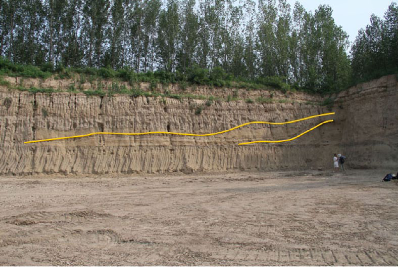
Surface erosion and material re-deposition were common at c. 4400–3900 BP, resulting in variations in magnetic susceptibility and episodic interruption of soil formation (e.g. Ustic Luvisols; Huang et al., 2007a). Intensified erosion is marked by the creation of massive erosion gullies on the CLP, although we do not have direct evidence about when this started. At Taosi, the stratigraphic relationship between a Late-Holocene gravel layer (4600 BP, 10 cm in thickness and sporadically present), several erosion gullies, and related features clearly points to human-induced erosion and the subsequent formation of gullies (Figure 5; He, 2013; Li et al., 2013).
Most eroded materials were transported into the Yellow River. Shi constructed a model for sedimentation rate changes based on hundreds of radiocarbon dates and sedimentary records and suggests a three-stage transformation of average sedimentation rates of the Yellow River, from 0.2 cm/yr in the period 11,000–7500 BP, through 0.25 cm/yr in 7500–3000 BP, to 0.22 cm/yr from 3000 BP to the present (Shi et al., 2002). This trend is clearly supported by other studies. Xu (1998), for example, based on similar kinds of data, notices two evident changes in ‘temporal variation in mean sedimentation rate’ of the Yellow River, one starting at c. 4800 BP and the other from c. 1400 BP.
Late-Holocene floods
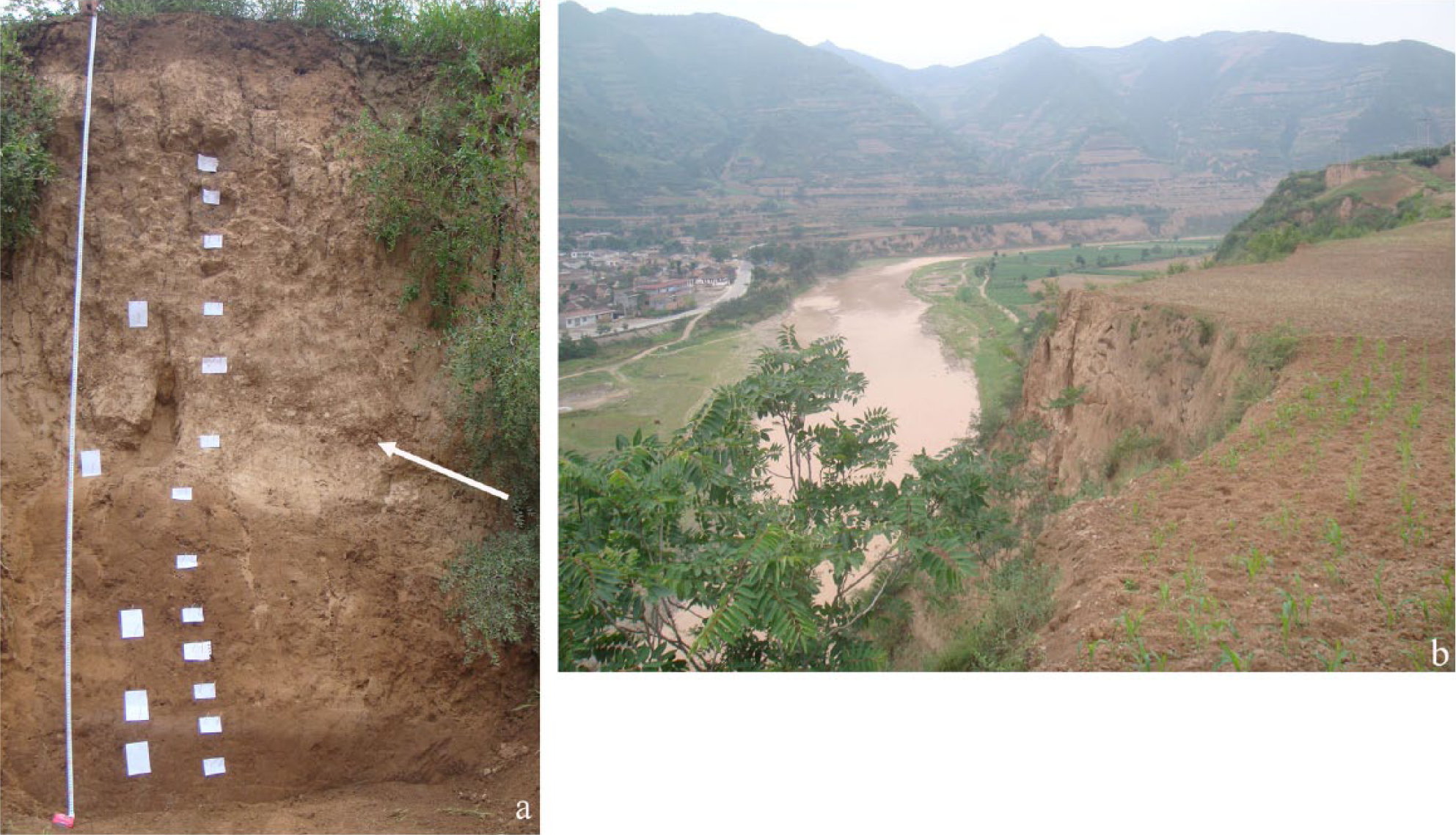
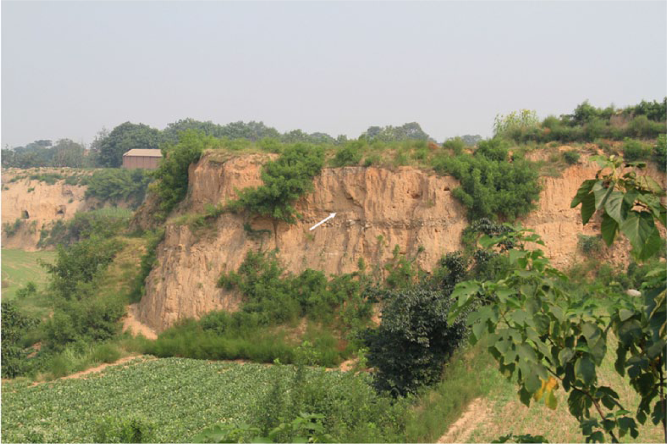
There is growing evidence of widespread floods taking place during this period that are often attributed to climate change (e.g. the 4200 BP event; Wu and Liu, 2001; Xia and Yang, 2003; Zhang and Xia, 2011), although the correlation between this climatic event and the floods remains controversial (cf. Butzer, 2012; Giosan et al., 2012a). Many sites in the CLP bearing such evidence are situated in highlands (where local ecosystems are vulnerable to changes) along second- or third-order tributaries of the Yellow River (Huang et al., 2010: Figure 1). At Chengjiachuan on the Jinghe River (Figure 2-8), slackwater deposits derived from overbank floods dated by OSL to 4100–4000 BP were found overlying a Late Neolithic settlement (Figure 6). Colluvial deposits containing pottery sherds, charcoal, and burnt earth aggregates are present in these flood deposits. This indicates that floods occurred intermittently with local colluviation events (Huang et al., 2010). Similar types of flood deposits with the same chronology and same stratigraphy are observed in the adjacent Qishuihe River (Figure 2-9; Huang et al., 2011) and in other rivers (Ge et al., 2010; Li et al., 2009c; Tan et al., 2008; Wan et al., 2010; Zhang, 2010: 23–26; Zhu et al., 2010b) and at some large Longshan walled sites (Wu and Liu, 2002; Xia and Yang, 2003; Zhang, 2010: 23–26). These deposits suggest that the flooding is partly associated with increasing human-induced erosion and that there is a complex relationship between climate change and intensified human land use.
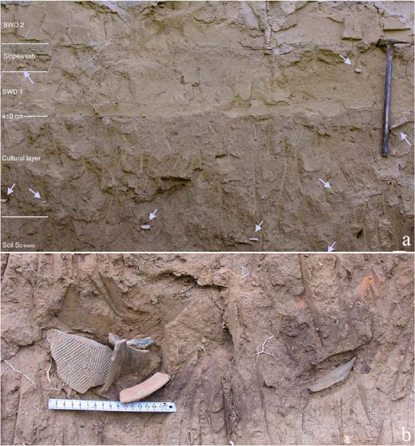
Late-Holocene flooding deposits in the Jinghe River: (a) palaeoflood deposits overlying the cultural layer that contains Late Neolithic pottery sherds (arrows) and (b) pottery sherds in contexts (after Huang et al., 2010).
Bronze Age and early Iron Age (4000–2200 BP): Establishment of states and increasing human impact
Climate, appearance of urban centers, and economic development
Moisture as a whole decreases at this time, but there are periods when temperature and moisture fluctuated (Dykoski et al., 2005; Zhou et al., 2010). Human intervention in the environment intensifies in the Bronze Age as populations increased, technological developments became more sophisticated, and socio-political complexity expanded with the establishment of state-level societies (Liu and Chen, 2003, 2012: Chapter 8; Underhill, 2013).
There is a noticeable reduction in the absolute numbers of settlements during this period (Wagner et al., 2013), which accords with historical records (Sai Ma, personal communication, 2013). This pattern is probably the outcome of population nucleation in fewer but more densely settled communities. Urban centers developed with rammed earth platforms for palaces (e.g. the Erlitou site and Zhengzhou Shang City; von Falkenhausen, 2008; Xu, 2000) and craft areas for the production of elite and non-elite goods (Yang and Gao, 2003). Metallurgical production expanded, and numerous bronze vessels were produced (Bagley, 1999; Li, 2006; Linduff and Mei, 2009). Extravagant elite burial practices now included the use of timber to construct wooden coffins and chambers; vast quantities of metal objects, jade items, and other burial goods were used (Bagley, 1999; Rawson, 1999; Yang and Gao, 2003). Increasing military activities stimulated the production of metal tools for warfare, thus also affecting resource consumption.
Archaeobotanical and other direct agricultural data are scarce at this time. Nevertheless, limited archaeological information and inscriptions from oracle bones and bronze vessels indicate that (a) farming fields were generally larger in size, meaning more arable land was exploited (Qiu, 1992; Zhang, 2007); (b) a mature inter-cropping system was established (CRWTLC, 2002: Chapter 9; Zhao, 2005, 2007); and (c) large-scale irrigation facilities were constructed and managed at the state level (Sun, 2004; Wang and Zhang, 1990). More importantly, by the end of Bronze Age, iron farming tools and animal traction were widely applied (Bai, 2005; Chen and Chen, 2006). For example, Kidder et al. (2012b) have identified Late Neolithic and Early Bronze Age field systems at Sanyangzhuang (Figure 2-10). These fields extend over 500 m, suggesting a substantial investment in agricultural production. At Anshang (Figure 2-11), micromorphological analysis of a palaeosol that formed between 4100 and 3100 BP indicates extensive human modification in the form of fragmented crust surfaces, charcoal pieces, and disrupted soil aggregates. They also found irrigation ditches dating to the Late Bronze Age (c. 3000 BP) that were covered by a two-stage artificial levee built at c. 2700 BP when an ancient Yellow River channel threatened the area (Figure 7; Kidder and Liu, 2014).
Two episodes of levee construction (yellow lines) at Anshang, Neihuang County, Henan Province (dates to c. 2700 BP).
Huang suggests that among the 61 reservoirs built prior to the Han era across China, 48 of them were built along the Yellow River basin, and 13 of 14 artificial canals were dug in the same regions (cited in Hsu, 1980: Chapter 4). The grandiose Zhengguo Canal, initiated by the Qin state (246
Pollen and vegetation change
At Zaojiaoshu (Figure 2-12), variations in pollen concentrations of Pinus and Artemisia at 4000 BP and in the Eastern Zhou period (c. 2700 BP) are possibly related to climatically driven increasing aridity. There is no strong palynological evidence of anthropogenic disturbance (CRWTLC, 2002: 90–101). These results, however, contradict the archaeobotanical analysis. Carbonized seeds of millets, wheat, soybean, and weedy species confirm an advanced stage of farming that probably involved inter-cropping (CRWTLC, 2002: 101–113).
In many pollen diagrams, however, large-sized cereal pollen grains are commonly present (Zhang, 2010: 35–37). They are especially abundant after c. 3000 BP (Sun and Xia, 2005), along with the presence of anthropogenic-related pollen taxa (e.g. weedy species and species that mainly appear in anthropogenically disturbed areas). This evidence supports historical texts that indicate that the Pre-Zhou and Western Zhou periods witnessed substantial increases in dryland farming in the CLP (Liu, 1992; Luo, 1995; Yang, 1992). Forest clearance increased considerably as suggested by the sharp decrease in arboreal pollen in many places (Cao et al., 2010; School of Archaeology and Museology, Northwest University, 2000: Appendix 1; Xu et al., 2002). This trend is particularly evident in charcoal records.
Fire and deforestation
The 3100–3000 BP period saw milestone changes in local ecosystems mainly because of rapid deforestation (Tan et al., 2005; also see Table 1). Oracle bones record that the Shang kings frequently used fire as a means of hunting and also to clear fields for cultivation (Keightly, 2012: 161–168). A spike in charcoal concentrations of variable sizes is widely seen in records across North China (Huang et al., 2006b; Tan et al., 2005; Wang et al., 2004). Although communities living in peripheral areas (e.g. the areas near the MYR, bordering the Northern CLP and Inner Mongolia Plateau) may have turned to pastoral land use because of political and/or climatic reasons (cf. Wang et al., 2013), we do not find evidence of diminished human impact on local landscapes as a contemporary, parallel increase in charcoal concentration is also observed in these regions (Huang et al., 2006b; Wang et al., 2013).
Land degradation and erosion
Soil evidence indicates increasing land degradation and erosion during this period. First, there is ample evidence of soil modification stemming from intensified land use. This includes substantial increases in organic carbon, total N, and organic P in cultivated soils in the Yi and Luo Rivers (Dong et al., 2007) and widespread land degradation in the Southern CLP indicated by richness of and variations among mobile elements such as CaO, MgO, Na2O, P, and Sr and other heavy metal elements, which suggest disruption of usual pedogenic processes (Huang et al., 2007a, 2009). Most seriously, as a result of the combined effect of deteriorating climate and intensified land use in the Central CLP, soil biological activities were significantly reduced and poorly developed soil structures predominate (Huang et al., 2003a). Among the consequences of this degradation are coarsened soil fabrics, reduced soil water retention, and increased soil alkalinity (cf. Huang et al., 2003a).
Second, massive-scale metallurgical activities during this period caused significant pollution. This pattern has been corroborated by an examination of lake sediments in north and central China, which finds excessive concentrations of Cu, Ni, Pb, and Zn were produced by metallurgical activities from about 3000 BP onward (Jin et al., 2013; Lee et al., 2008).
Third, evidence of surface erosion is common. In the Eastern CLP (Huang et al., 2006a), sediments OSL dated to c. 4000–3600 and 3100 BP, respectively, are dominated by poorly sorted, angular coarse minerals and sometimes pebble-sized clasts derived from surface sheetwash (Jia et al., 2008; Pang et al., 2005; Zha et al., 2005). In tributaries of the Yellow River, there are also records of floods happening in the Late Bronze Age (Huang et al., 2011), greatly accelerating the sedimentation rate. At Yangguanzhai (Figure 2-13), for instance, nearly 1-m-thick sediments were deposited in 300 years, a much higher deposition rate than those of the overlying and underlying sections (Gu et al., 2011; Huang et al., 2007b: Figure 3). At Sanyangzhuang and Anshang, sedimentation rates were increasing from 3000 BP onward and are associated with more frequent Yellow River floods (Kidder et al., 2012a, 2012b). In addition, because climate variability was increasing, intensified land use resulted in a landscape more vulnerable to erosion in periods of frequent wet–dry climatic alternations.
Early Dynastic times
Agricultural development
The Qin Empire (221–206
Both ceramic and metal manufacturing reached remarkable levels of sophistication (Bai, 2005; Wagner, 2001; Zhao and Gao, 2002). Intensive utilization of iron casting technology was employed to make agricultural tools and implements (Bai, 2005: 163–211). Agricultural technology was greatly improved by the broad application of these tools, the use of animal traction (Sun, 1991; Xu, 2005), fertilizers, and improved irrigation technology (Gong, 1995; Jing and Hui, 2007). Industrial development was also assisted by innovative tax and social policies (Twitchett and Loewe, 1986: Chapter 10).
The Han also emerged at a time when the monsoon cycle was at or near its weakest. Climatic variability seems to have increased, and droughts, often followed by devastating floods, were a frequent occurrence. Environmental catastrophes are often mentioned in the increasingly rich historical record (Ma, 2003).
Desertification
The Han were imperialists who expanded their borders by aggressive military, social, and economic policies. One of the strategies of the Han Empire in dealing with neighboring regional policies was to establish military outposts on the borders. Large numbers of people, who were originally agriculturists in central China, were moved to peripheral areas (Deng et al., 2001; Loewe, 2006), especially along the northern and western frontiers. The intermediate regions between the Ordos Plateau and the CLP, for example, were increasingly populated during the Han period, with the construction of some large cities and towns (Wang, 2002). These immigrant communities were expected to be economically self-sufficient, requiring the inhabitants to practice intensive agriculture in environmentally marginal areas. These circumstances were exacerbated by the weak monsoon, which led to increasing aridity in the northwestern parts of the empire. The consequence of the intersection of climatic, socio-political, and technological changes was significant degradation of the environment and the emergence of extensive desertification.
Eolian processes and sand-dune formation have been active in this environmentally sensitive region since the Late Pleistocene (Sun et al., 1996), and a mosaic landscape consisting of sand dunes, lakes, and loess lands has been dominant during the Holocene (Ma et al., 2011). Human activities, however, accelerated desertification in this region (Deng et al., 2001). This idea is supported by environmental and archeological studies in and around the Mu Us desert (Figure 2-15; Deng et al., 2001; Sun, 2000; Wang, 2002).
During the early Western Han, population in this area rapidly increased to 606,658 (Deng et al., 2001; Ge et al., 1997: Chapter 5). A great deal of arable land (8.3 million hectares, Zhang, 1999) was reclaimed, and irrigation facilities were established (Chang, 2007; Loewe, 2006; Sun, 2000). Resources, such as wood (Fang and Xie, 1994), topsoil, and water, were consumed for the construction, feeding, and maintenance of cities (Deng et al., 2001). The removal of vegetation for agriculture and changes in local hydrology for irrigation in turn greatly increased sand-dune formation. Sandy materials from barren surfaces were mobilized by prevailing winds and encroached on human settlements and facilities. The ongoing battle between desertification and human occupation is illustrated by the relationship between naturally formed sandy layers and archaeological sediments at and around archaeological sites. At the Han period Dabaodang site (Figure 2-16), for example, thin sandy deposits cover or alternate with rammed earth city walls or occupation levels (Wang, 2002). Similar stratigraphic records have been reported elsewhere (Hou, 1973; Jing, 1999). Some lakes completely dried up because of insufficient water supply, increasing domestic and agricultural use of water, rapid desertification, and climate change (Sun, 2000; also cf. Yang et al., 2011). In these dry environments, the local ecology, once destroyed, is hard to return to its original state.
Soil modification and soil loss
Sufficient agricultural yields (mainly wheat) during the Early Dynastic period were achieved by deliberate soil modification, establishment of regular systems for plowing, planting, weeding, and harvesting (Jing and Hui, 2007), and maintenance of in-field hydrology by changing micro-topographies (Hsu, 1980). These activities not only disrupted the formation of the Late-Holocene soil at a scale not seen before but also, in some areas (e.g. Ordos), entirely destroyed sub-soils (Xu et al., 2002), which are fundamentally important for a resilient local ecology. Detailed information about the chemical/physical properties of these cultivated soils is not widely available yet (but cf. Huang et al., 2009); however, Early Dynastic soils in most parts of North China are darkish in color and have dense soil structure and enriched organic matter (Kidder et al., 2012b; Liu, 2011; Liu et al., 2004b; Zhu et al., 2010a), resembling the characteristics of anthrosols in other parts of the world (Glaser and Woods, 2004; Macphail et al., 2002). Ecological consequences of anthrosols have been well studied elsewhere (Glaser and Woods, 2004; Goldberg and Macphail, 2006: Chapter 9). Potentially, the altered soil structure (e.g. compaction) has a direct effect on soil water retention and will thus affect plant growth (Soane and Ouwerkerk, 1994); enrichment of chemical elements will also have an effect on the long-term maintenance of soils and their sustainability (Connor et al., 2011: Chapter 12).
Society was also faced with severe soil loss. In Ordos (Figure 2-17), the Late-Holocene soil was churned up and washed away because of diminished surface vegetation cover (Xu et al., 2002). Similar problems were widespread in the CLP. Dramatically increased sediment input into the Yellow River as a direct consequence of increasing erosion upstream is noted from c. 2500 BP onward (Kidder et al., 2012a, 2012b; Shi et al., 2002; Xu, 1998, 2010), mirroring many historical records stating that the Yellow River became heavily silt-laden during this period (Li, 2004). The direct relationship between erosion and sediment budget of the Yellow River is confirmed by studies focusing on the impact of modern land use in the catchments of the river (Fan et al., 2006; Xu and Cheng, 2002; Xu et al., 2006).
Yellow River floods
The predominance of wheat farming in the Early Dynastic period (Jing and Hui, 2007) rendered the society more and more reliant on the Yellow River and its tributaries for rich alluvium and irrigation. In this period, we see the emergence of large-scale farming on Yellow River floodplains (Kidder et al., 2012a, 2012b; Liu, 2011; Zhu et al., 2010a). Increasing use of the floodplain for intensive agriculture is coupled with growing investment in flood control. This comes at a significant cost. Attempts to control the river through levee construction and other forms of flood control altered avulsion patterns of the river because of rapidly aggrading channels following increased erosion upstream and changing flood basin gradients downstream (Chen et al., 2012).
In the lower reaches of the Yellow River, the trunk channel had been in a relatively stable position along the western margin of the NCP for much of the Holocene. However, evidence from various sources (Chen et al., 2012) indicates that by the end of Western Han the Yellow River trunk channel underwent a major avulsion and relocation to a position east of its previous location. The specific causes of this avulsion are difficult to identify, but the major reason for the avulsion was rapid channel aggradation and increasing slope advantage relative to the flood basin to the east aggravated by unstable bank conditions caused by coarse-textured substrates (Chien, 1961) that facilitate channel scouring, bank failure, and development of crevasse splays (Aslan et al., 2005; Phillips, 2011).
Rapid channel aggradation is facilitated by increasing sediment loads coupled with anthropogenic modifications of the channel position by levee construction. Sediment yields were increasing rapidly. At Anshang, there is evidence of at least two levee construction episodes begun by c. 2750–2500 BP, with the second following soon after the initial building event. This second event doubled the height and width of the levee and is associated with a massive increase in sedimentation in the NCP (Figure 7).
Levee construction ensured that successive river breaks were catastrophic over a large area. A massive flood happened at c.
The effects of this flood can be seen at Sanyangzhuang. Here, 15 exceptionally well-preserved Han-era agrarian domestic compounds have been discovered beneath flood deposits, along with an ~10,000 m2 building, a kiln, walls of a contemporary town or small city, and farming fields (Figure 8; Kidder et al., 2012a, 2012b). Excavations at Sanyangzhuang clearly demonstrate the massive extent of landscape transformation during the Han Period, which is supported by survey in surrounding areas. Orderly plowed fields, roads, houses, towns, wells, human-made ponds, industrial facilities, and flood control features indicate that the landscape in this area was entirely domesticated (Figure 8).
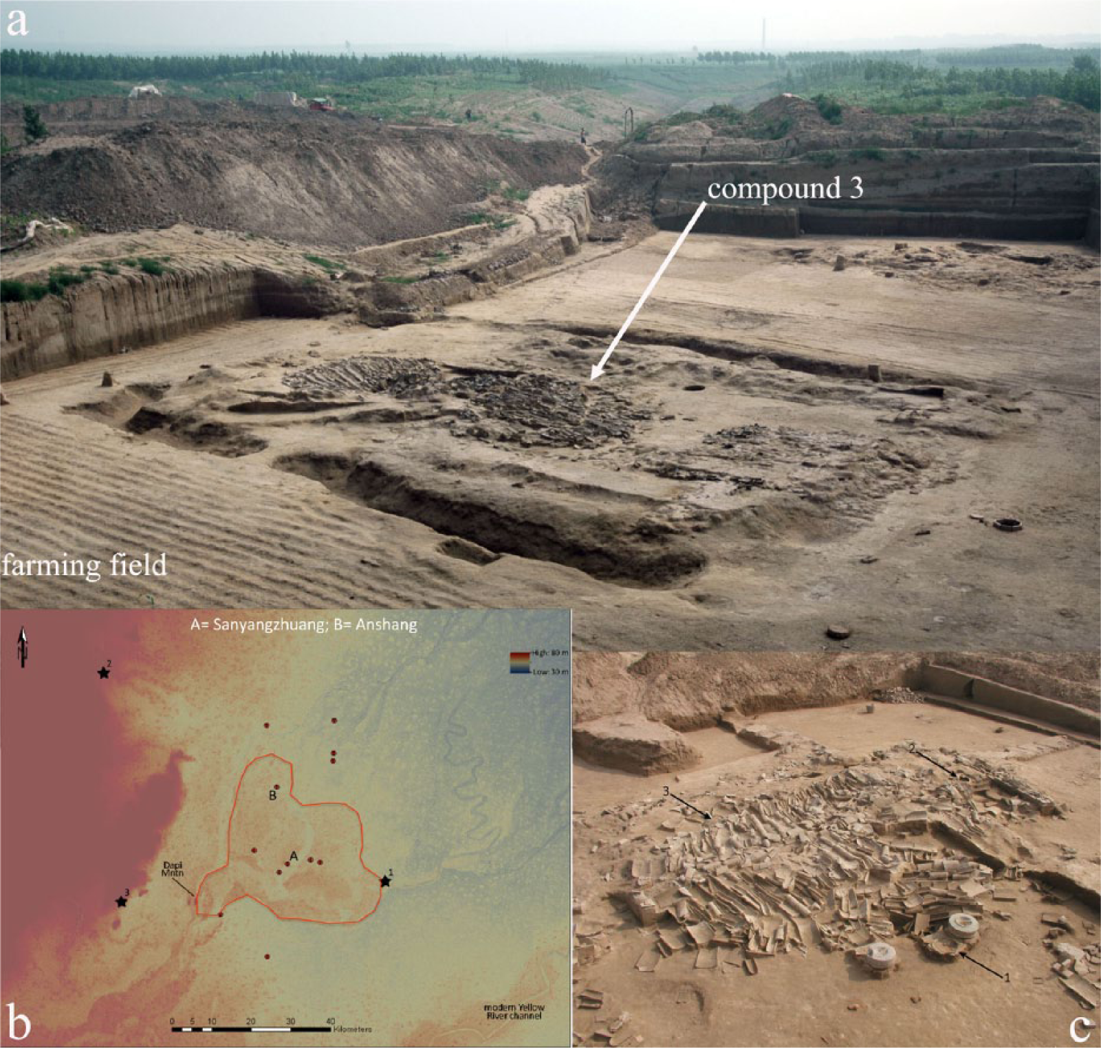
Excavation at the Sanyangzhuang site, Neihuang County, Henan Province: (a) compound 3 showing collapsed houses and well-preserved farming fields, (b) satellite map showing the area (circular line) covered by the flood (note the scale), and (c) details of the collapsed roof from compound 2 (after Kidder et al., 2012a).
By the Early Dynastic period, it is reasonable to say that human forces had become inextricably entangled with geological and environmental processes. The floods at the end of Western Han exemplify the complex relationship between human action and environmental consequence.
Discussion and conclusion
Agriculture and intensified water management
Data synthesized above demonstrate a general trend wherein ancient Chinese societies intensified agricultural and other forms of production through time and in doing so altered their physical environment at increasingly large and socially consequential scales. Although land use intensification is traditionally driven by increasing population pressure, we recognize that while the general trend is toward greater productivity, this trajectory is neither smooth nor continuous (Ellis et al., 2013b: Figure 3) because of myriad social, economic, technological, demographic, climatic, and environmental constraints and feedbacks. It is thus unwise to see anthropogenic environmental change as a uniform, linear process. The deployment of water management practices through time amply demonstrates the complexities of the intensification process.
Modern agronomic research confirms that water plays a more important role than temperature and other ecological parameters in determining long-term agricultural yields (Connor et al., 2011; Li, 2007; Shan et al., 2004). This is particularly true in arid or semi-arid areas where evapotranspiration is high and effective moisture varies greatly in different micro-environments (Li, 2007). Research around the world has illustrated a close relationship between water resource and management, development of prehistoric agriculture, and evolution of ancient civilizations (Mays, 2010; Mithen, 2012; Mithen and Black, 2011; Sherratt, 1980).
Initial water-use strategies for early farming in North China mainly involved careful choice of locations for farming fields and settlements to take advantage of seasonally available water and natural resources. Prehistoric people used topographic differences to direct water to lower relief locations for daily and agricultural use. Such methods are widely applied by tribal agricultural groups in arid areas of the world (Mainguet, 1999) and might lower the pH values of soils, which potentially would have an effect on agricultural yields in the long run.
The expansion of rice cultivation to North China (from where and how are issues open for debate) in the Middle Holocene stimulated experimentation with deliberate water management strategies. In addition, the construction of ditches surrounding settlements (e.g. Banpo, Institute of Archaeology, Chinese Academy of Social Science, 1963) may have also enhanced water management for domestic and agricultural-related activities.
Agricultural development in the Late Neolithic was accomplished through advances in water management coupled with changing socio-political and economic organization. This period saw rapid population expansion to highland areas in North China. An ensuing challenge faced by these migrants was how to transform their new local habitats into one suitable for sustainable farming. Construction of moats and wells was among the new solutions to cope with ecological challenges. Intensification of economic production and changes in societal organization were unprecedented and deeply shaped the trajectory of social development. Labor management would have played a central role in this process.
Land use intensification and its relationship to changing socio-political organization are more clearly seen in the succeeding periods. From the Late Bronze Age to the Early Dynastic periods, massive population expansion and the predominance of wheat farming forced people to build their settlements on floodplains near major rivers. As economic investment in these areas increased with the construction of large-scale irrigation systems and the building of canals for water control and transportation, more resources became fixed and thus vulnerable to environmental perturbations. This set in place a negative feedback loop as resource defenses became necessary to protect the investment in land use intensification and populations became more and more dependent on the products of these efforts. Greater labor efforts were required to build large-scale engineering projects to direct water for irrigation and to replenish cultivated soils with the Yellow River alluvium in the MYR and LYR. These large-scale public works fundamentally changed the landscape across the Yellow River and its tributary basins.
While the society clearly benefited from the construction of these water management facilities, the increasingly large and concentrated populations living in the floodplains were exposed to severe risks of floods. This is partly because of changing monsoonal rainfall patterns and the consequent seasonal variations of river water levels, but political and economic mis-planning and intensified water management also worsened this problem. Construction of reservoirs and ditches, for instance, significantly reduces water velocity, which results in increased sedimentation rate. Moreover, the reclamation of lakes and wetlands for farming was at the expense of weakening their ability of absorbing flooding water (Wang, 2005). Historical texts record that the function of some reservoirs failed quickly as a result of mis-management, leading to small-scale floods that covered nearby villages (Hsu, 1980: 111). One solution was to build levees to protect against the floods. During the Han era, the construction of levees indeed became a political action governed by the imperial authorities (Wang, 1999).
By emphasizing levee building and associated flood control efforts, residents in the floodplains were trading relatively high-frequency but low-amplitude flooding for increasingly high-amplitude but low-frequency flooding. Once built, these levees require regular and costly maintenance. The choice had been made to invest in short-term solution for a long-term problem. The Wu Di Emperor, considered to be one of the greatest Han emperors, for example, participated personally in the rebuilding of a failed Yellow River levee (Ma, 2003; Wang, 1999). This event illustrates how humans and the environment interacted in this new era:
We pile the long stakes at the breaches and cast precious jades into the river. The Lord of the River hears our plea But there is not enough brushwood. There is not enough brushwood – The fault of the people of Wei. All brushwood is used as fire for [the] living. What can we do for flood prevention?
The reference to wasting the land with fire is telling and suggests that the level of human degradation of local and regional environments was so significant that it frustrated even Wu Di (Sima, 1959: 1413).
By Han times, societal evolution, technological innovation, environmental degradation, and water conservancy were inextricably linked. Facilities for irrigation and related uses were constructed in many environments and at an unprecedented scale (Wang, 1999). These investments in water management and control facilities expanded the Han agrarian economy and strengthened the Han rule over its vast territory. One of the dangers of these policies was, however, that they lead to monopolization of water and related resources because the facilities were mainly financed by wealthy nobility who were able to employ labor input at industrial scales (Wang, 2005). These efforts lead to over-exploitation of land and resources and in turn inevitably stimulated social instability and conflicts between farmers and elite groups.
The conflict between community economic growth and environmental degradation became more and more intense and was intertwined with increasing conflicts within and between segments of society. These entangled relationships bent the arc of China’s history. For example, the catastrophic flood that happened in
Increasing land use, erosion, and solutions
During the Early Holocene, ‘the mixed economy of foraging and millet farming seems to have had little impact on the soils and hydrological balance’ (Rosen, 2008: 305). During the Yangshao period, improved building technologies and dramatic increase in house numbers must have been associated with ‘a stronger ecological impact’ (Rosen, 2008: 305). These ecological consequences, however, were mainly localized in tributary basins.
The latter part of the Holocene witnessed the onset of the ancient Chinese Great Acceleration, with land erosion and far-reaching environmental effects becoming more evident across vast areas of North China. By this time, climatic and environmental changes were acting in concert with growing population and rapid technological innovation. The discussion of the trigger(s) of the frequent floods taking place in the period c. 4200–4000 BP emphasizes this point particularly. Climate change is implicated as the driving force causing these floods. However, while acknowledging that climate change, variations in sea level, and tectonic activities played a role in the evolution of river behaviors, we also suggest that severe deforestation and intensified land use contributed to the frequency and disastrous effects of these floods.
By the Late Bronze Age to the Early Dynastic times, the environmental situation deteriorated. People were aware of the ecological consequences, and this recognition stimulated efforts to try to limit these detrimental processes. They constructed levees and dams, built terraces, and enacted associated laws (Wang, 2005; Zhang, 1999). Some of these adaptations were probably quite successful, while some were doomed to fail because they did not meet the needs of the growing population or because they did not suit the short-term considerations of economic-driven decision making.
Greater intensification drove human–environment relationships to a new level; more and more, anthropogenic effects were irreversible and led to conflicts between growing populations and limited or diminishing natural resources. Increasing aridity caused by gradual climate change and coupled with human-induced landscape degradation led to and amplified increasingly frequent and ever large-scale catastrophic events, such as floods and droughts. These events often exceeded the capacity of the society to adapt, leading to significant political and social challenges. Growing social and political rigidity, including the monopoly of land and resources by the elites since the Late Bronze Age, for example, exacerbated this problem.
Early origin of the Anthropocene in China and its implications
Although there are concerns that pre-modern people could not have transformed their environments at scales sufficient to alter regional and even global ecosystems, accumulating evidence demonstrates that the anthropogenic footprint is widespread and considerable. Ancient China, with its relatively large populations, remarkable technologies, and high levels of intensification through time, is one of the epicenters of the Early Anthropocene. Understanding China’s environment today must account for the roles that humans played in altering their environment in the past. While the scales of change are markedly different today, anthropogenic change in ancient China is not completely unlike what we are witnessing presently. These changes started slowly in the Early Holocene, and the pace of change accelerated rapidly through time. Ancient China sees its own version of the Great Acceleration, with technological, social, economic, and environmental shifts happening rapidly since the Late Neolithic. There were unprecedented scales of change in geomorphology, vegetation, soil, and hydrology. Although natural climate processes affected these environmental changes, they were at their root human transformations. The formation of massive gullies in the CLP triggered by local erosion and increasing flooding and sedimentation in the LYR highlight the early beginnings of large-scale human alteration of the landscape.
By the Late Bronze Age to Early Dynastic times, societies frequently traded short-term economic interests for long-term sustainability. Increasing populations that demanded more food resources coupled with technological innovation that required more and more energy to produce led to over-exploitation of resources and land in the long run. The effects are seen at larger scales such that the entire Yellow River Basin is made into an anthropogenic landscape. By these periods, environmental change had advanced to a point where it effectively exceeded the capacity of the society to harness and manage it. The result was the loss of social and political resilience and consequent social instability.
The Early Anthropocene concept is more than a change in atmospheric chemistry; in ancient China, the Anthropocene is realized at every level of the physical world. These data force us to entertain a fundamental shift in our thinking about how humans interact with the environment. Rather than seeing humans as dependent on climate and the environment, we must reconceptualize this relationship and understand it as dialectical, recursive, and temporally dynamic. The Anthropocene is not solely the product of the Industrial Revolution; our data indicate that in China, and probably elsewhere (Bintliff, 1992, 2002; Hughes, 1994; Thommen, 2012; Van Andel et al., 1986, 1990; Wilkinson, 2003, 2010), humans have been active agents in transforming the physical properties of land, water, and even atmosphere for much of the Holocene (Hong et al., 1994, 1996; Sapart et al., 2012), and in doing so, they shape their own behavior and history. An in-depth understanding of these changes and the adaptations they require has broad implications for our modern society.
Footnotes
Acknowledgements
The authors would like to thank the colleagues who have read and provided valuable advice on the previous drafts. They include Dr Matthew Edgeworth (University of Leicester), Dr Sai Ma (Minzu University of China, Beijing), and Miss Chao Tang (Beijing). TR Kidder would like to thank Professor Haiwang Liu (Henan Provincial Institute for Archaeology, Zhengzhou), Professor Dowen Mo (Peking University, Beijing), Mr Zhen Qin (Washington University in St Louis), the Henan Provincial Institute for Archaeology, Zhengzhou City, and the International Center for Advanced Renewable Energy and Sustainability. Yijie Zhuang would like to thank Professor Jessica Rawson (University of Oxford) for helpful discussion.
Funding
This research received no specific grant from any funding agency in the public, commercial, or not-for-profit sectors.