



Abstract
Permanent cultivation is generally believed to have been established in the interior of northernmost Fennoscandia later than elsewhere in northern Europe, during or after the late 17th century. Although subtle evidence from various pollen records suggests cultivation may have occurred much earlier in this region, such indications have generally been disregarded. We hypothesized that cultivation was introduced early in the Lapland border zone where western native Sami interacted with coastal farming societies due to the high degree of contact between these communities. Therefore, we investigated historical land usage at three settlement sites in the interior of Sweden’s northernmost territories – two in the Lapland border zone and one in a more westerly traditional Sami area. Analyses of pollen, charcoal and written historical records indicated that cultivation first occurred in AD 800 (700–900) at the westernmost site and one of the border zone sites. Permanent cultivation appears to have been established in c. AD 1480 (1400–1560) and 1750 (1720–1810) in the two Lapland border zone settlements and around AD 1840 (1725–1940) in the westernmost settlement. These results suggest that small-scale shifting cultivation may have been conducted in inland regions of Northern Fennoscandia (including a traditional Sami area) since AD 800. As such, they support the hypothesis that intermittent small-scale cultivation has been going on in these regions for much longer than was previously accepted. Because there was a great mobility of people and ideas across northernmost Fennoscandia, we conclude that the current tendency to describe specific geographical regions as being solely used by ‘nomadic herders’ or ‘permanent farmers’ is inappropriate and fails to capture the complexity of historical land usage.
Introduction
Northern Fennoscandia has a land-use history that differs from most other areas of Europe. Its cold climate, short vegetation period and low human population density have historically been considered to imply limited human impact on its ecosystems. For example, the clearing of forests for agricultural purposes is a very recent phenomenon (e.g. see Kaplan et al., 2009). The interior parts of Norway, Sweden and Finland are traditionally regarded as the last European regions in which cultivation was established (Andersson et al., 2005; Hultblad, 1968; Rudberg, 1957; Wallerström, 1995). However, during the last few decades, this view has been challenged by palynological findings, indicating that these regions have a complex land-use history: there is subtle evidence of localized agricultural activity at much earlier points in time than is generally accepted (see Josefsson et al., 2014, for a review). However, there are several issues with the interpretation of such stray finds of cereal pollen, for example, problems regarding identification, long-distance dispersal, reliable dating and contamination (Behre, 2007; Lahtinen and Rowley-Conwy, 2013), and these recordings are not generally considered sufficiently convincing to change the traditional view. More data are, therefore, needed to determine whether these stray finds of cereal pollen are genuinely indicative of early low-intensity cultivation, especially from the Lapland border zone (Swedish: Lappmarksgränsen) in the interior of northernmost Sweden. Up until the early 20th century, the Lapland border that runs parallel to the coastline of northernmost Sweden and Finland was an important administrative boundary between the coastal areas, which were predominantly agricultural, and the interior region where the establishment of permanent settlements by farmers was prohibited, and the native Sami people held the right to use the land according to their traditions (Bylund, 1956; Statens Offentliga Utredningar (SOU), 2006) (Figure 1). The conventional view is that land use in the interior regions was restricted to hunting, fishing, gathering and reindeer herding until the 1700s (Campbell, 1948). Therefore, the Lapland border has been regarded as a line of demarcation that separated two regions with very different social, religious and judicial histories and also very different economic strategies. However, the idea that cultivation was restricted to the coastal areas of northernmost Sweden before the 1700s is now being contradicted by a growing body of scientific data (see Josefsson et al., 2014, for a review). Furthermore, there was extensive contact between people from the interior and the coast that led to exchanges of goods, customs, language and ideas across the Lapland border. Notably, during the 18th and 19th centuries, many Sami families abandoned their nomadic life style and established permanent settlements on their taxation lands (Swedish: skatteland) (Bylund, 1956; Campbell, 1948; Hultblad, 1968; Lundmark, 2006). To be able to evaluate the general view and the new contradicting view, described above, it is important to determine whether inland people incorporated cereal cultivation into their economy prior to their change in subsistence.
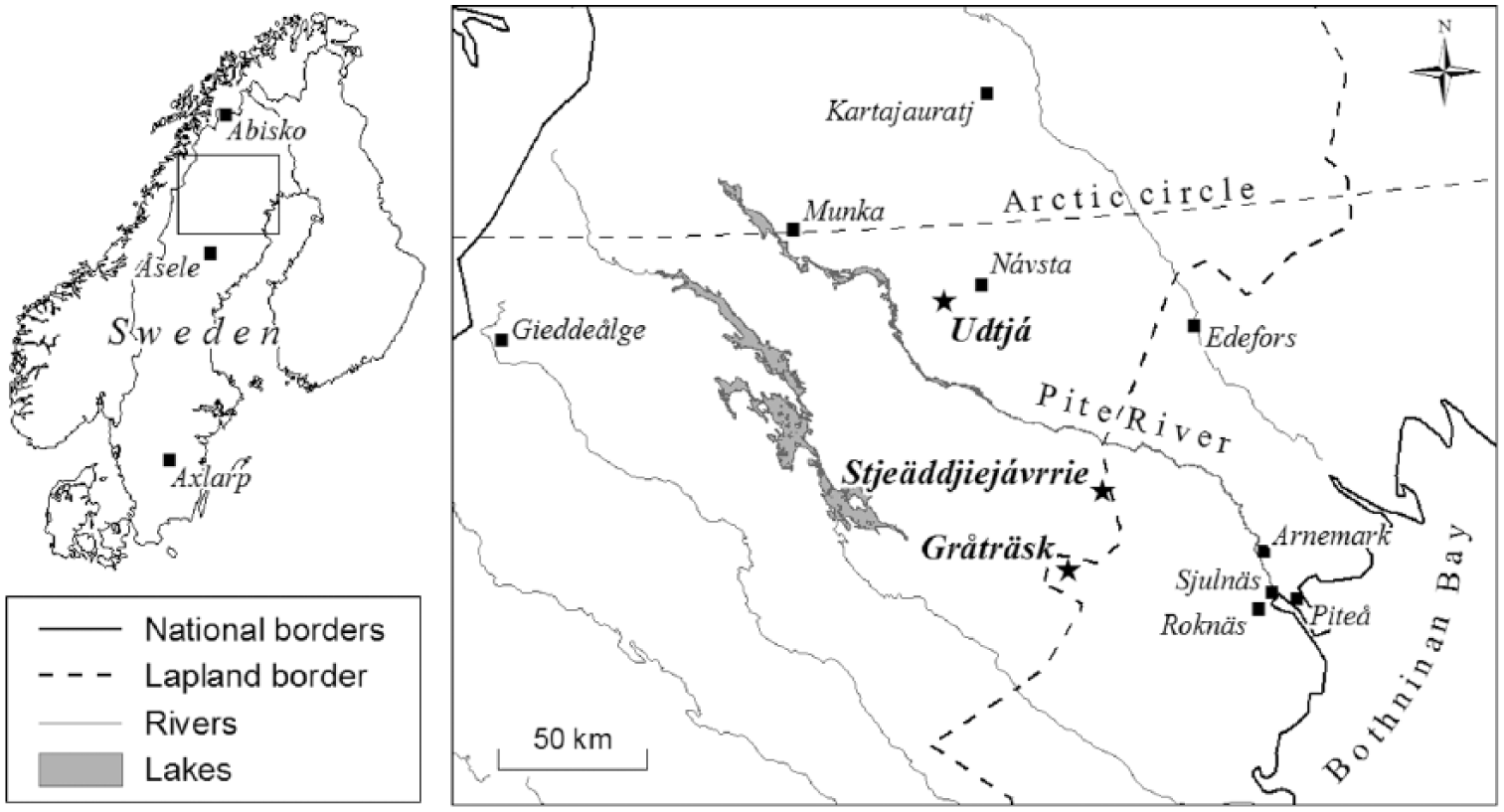
Overview map of Fennoscandia with the study area indicated by a rectangle and close up map with the locations of study sites (star) and place names (square) mentioned in the text. Place names outside the study region indicated on overview map.
In this study, we examined the land-use history of three settlements located in interior northernmost Sweden. Two are located in the Lapland border zone and one is located in a traditional Sami area west of the Lapland border. Names for places located west and east of the Lapland border are from now on given in Sami and in Swedish, respectively. Our hypotheses were that all three sites were used for hunting, fishing, gathering and animal herding before permanent settlements were established and that cereal cultivation was practised sporadically on a small scale in the two settlements located in the Lapland border zone but not in the westernmost settlement during the pre-settlement phase. By analysing pollen and microscopic charcoal particles from closed canopy sites in close proximity to arable land at the settlements, we aimed to (1) determine when these sites were first used by people, (2) identify vegetation changes associated with different forms of land use including sporadic cultivation and (3) determine when permanent cultivation was first established. Our results provide new insights into historical land use and cultural identity in northernmost Fennoscandia, both of which are complex topics for which there is currently a lack of firm scientific evidence. The results can also be used to assess the long-term consequences of low-intensity forest landscape use and the early establishment of settlements.
Study area
The settlements of Udtjá (Swedish: Udtja), Stjeäddjiejávvrie (Swedish: Städdjejaur) and Gråträsk (Sami: Jeärbmure) are all situated in Pite Lappmark in the boreal zone of northern Sweden (Figure 1). This region has a cool temperate climate; its mean annual, January and July temperatures are c. 0°C to −2°C, −12°C to −14°C, and 12°C to 14°C, and precipitation values are 500–600, 30–40 and 80–90 mm (www.smhi.se/klimatdata). The bedrock is mainly Vuolvojauregranite and biotitgneis in the Udtjá region (Lundin et al., 2012), and volcanic, belonging to the Arvidsjaur porphyry cluster, in the Stjeäddjiejávvrie and Gråträsk regions (Kathol and Triumf, 2000). All three locations’ soils are predominantly moraines, together with post-glacial sediments in areas closer to lakes. The forests are dominated by Scots pine (Pinus sylvestris) on dry moraines, by Norway spruce (Picea abies) and downy birch (Betula pubescens) on mesic soils, and by grey alder (Alnus incana) at wet sites.
Description of the study sites
The Udtjá settlement is located on the northern side of Lake Udtjájávvrie, about 65 km west of the Lapland border at 550 m a.s.l. and 150 km inland from the coast (Figure 1). The area was first described in historical records in the late 1600s, and the name Udtjá was first mentioned in AD 1776 (Sommarström, 1997), indicating that people have been using this land for several centuries. Officially, Udtjá was first settled at some point between AD 1826 and 1835 (Hultblad, 1968; Sommarström, 1997). Its local economy was traditionally based on reindeer (Rangifer tarandus) herding, hunting, fishing and gathering (Manker, 1949; Sommarström, 1997); no traditional farming involving cultivation was described until the early 1900s (Manker, 1968). However, according to Sommarström (1997), Hordeum was cultivated on old reindeer pens in Návsta (Swedish: Nausta) – a settlement located 13 km NE of Udtjá that was established in AD 1798 and where small-scale cultivation was documented during the early 1800s (Hultblad, 1968).
Stjeäddjiejávvrie settlement is located on the south-western side of Lake Stjeäddjiejávvrie, at 330 m a.s.l. and just west of the Lapland border. It is about 80 km SSW of Udtjá and 70 km from the coast (Figure 1). Lake Stjeäddjiejávvrie was mentioned as one of many lakes used for inland fishing by people from the coast during the 1500s (Berggren, 1995). This inland lake fishing (Swedish: träskfiske) in the interior of northernmost Sweden was regulated during the early 16th century by King Gustav Wasa and remained so for another century because a substantial part of the catch was paid in tax, providing the Swedish Crown with a considerable income. However, the Stjeäddjiejávvrie settlement was not mentioned in any historical records until the mid-1800s, when it was marked on a map drawn up between AD 1859 and 1878 (Lantmäteristyrelsens A, Table 1). When the rights of private individuals and groups to Crown estates in northern Sweden were reorganized (Swedish: avvittring) in AD 1881, Stjeäddjiejávvrie was one of the regions that was affected, and it was specifically recorded as having cultivated land (Lantmäteristyrelsens B, Table 1). The limited historical information available for Stjeäddjiejávvrie indicates that it was not a settlement of great importance. However, due to its location right on the Lapland border itself, its land-use history was probably similar to that of the nearby village of Gråträsk.
Unpublished sources used to extract historical data.

Gråträsk village is located on the west side of Lake Gråträsket just east of the Lapland border at 360 m a.s.l., about 30 km SSW of Stjeäddjiejávvrie and 80 km inland from the coast (Figure 1). Gråträsk is one of the oldest agricultural settlements in the interior of northernmost Sweden and is first mentioned in taxation records from AD 1543 (Nordlander, 1905; Riksarkivet A, Table 1). A few years after those records were made, individuals from two coastal villages (Roknäs and Sjulnäs) were taxed by the Swedish Crown for fishing in the lake from AD 1550 to 1590 (Berggren, 1995). At the time of the Älvsborg Surcharge (Swedish: Älvsborgs lösen; tax that Sweden paid Denmark in order to recover the fortifications in Älvsborg), AD 1570 to 1571 (Riksarkivet B, Table 1), two farmers were living in Gråträsk that together possessed six cows, three heifers, six sheep, seven goats and one horse. There were three farms in Gråträsk in AD 1607 and four by AD 1667 (Pellijeff, 1988). Its recorded settlement history is thus in good agreement with the prevailing view of the colonization process and cultivation history of northernmost Sweden. However, both palynological studies and archaeological finds have provided indications of human land use in the Lake Gråträsk area prior to this period, suggesting that the area was inhabited far earlier than the tax records show.
Pollen records reported by Aronsson (1991) and Karlsson (2006) for two sites located south and SE of Lake Gråträsk revealed the presence of scattered apophytes. Karlsson (2006) also identified Hordeum-type pollen that was dated to around AD 600 (uncal.), although this age is an approximation and therefore uncertain. Furthermore, there are several archaeological remains associated with this lake that have been dated to Neolithic and Iron Age times, indicating a multifaceted land-use history that precedes the oldest written historical records. For example, a silver buckle from the Middle Ages (AD 1050–1525) was found in association with an excavated hearth that was dated to the Late Iron Age (Fossum and Karlsson, 2003), and in AD 1897, the most notable archaeological find (Swedish: Gråträskfyndet) yet made in this region was discovered in a small lake located c. 2.5 km south-west of Gråträsk village (Zackrisson, 1984). This find featured more than 1000 metal objects including silver, bronze and tin coins, many of which were made between AD 750 and 1350. It also included a construction believed to be the remains of a wooden platform of the type traditionally used by Sami people for sacrificial purposes (Bergman et al., 2008). All of these finds raise questions regarding the land-use history of inland settlements prior to the establishment of the permanent agricultural settlements described in historical records.
Methods
Sampling and radiocarbon dating
Sampling sites were chosen based on information derived from historical records, the locations of the oldest known buildings in the three areas, the presence of fine soils suitable for cultivation and favourable local climate conditions. We collected peat cores using a Russian peat corer (Jowsey, 1966) in September 2010 (Udtjá) and August 2012 (Stjeäddjiejávvrie and Gråträsk) from small swamp forests situated c. 50 m from the closest arable field. The swamp forests, which have radii of 35 m or less, are likely to have functioned as closed canopy sites with a source area of pollen in which pollen of mainly local origin would have accumulated over time (Bradshaw, 2007; Sugita, 2007). The swamp forest at the Udtjá site (66°19′09″N, 19°00′30″E) extends over an area of 25 × 40 m. The topmost 17 cm of the peat at this location consists of lightly decomposed Sphagnum mosses, with moderately to highly decomposed Sphagnum peat further down. The tree layer is characterized by Norway spruce and downy birch; the field layer is dominated by dwarf birch (Betula nana), cloudberry (Rubus chamaemorus), sedges (Carex spp.), crowberry (Empetrum hermaphroditum), bog bilberry (Vaccinium uliginosum), wood horsetail (Equisetum sylvaticum) and bog-rosemary (Andromeda polifolia), and the forest floor is dominated by Sphagnum girgensohnii and Polytrichum commune. The sampling site at Stjeäddjiejávvrie (65°43 ′03″N, 20°05 ′17″E) is located at the edge of a swamp forest that extends over an area of 40 × 60 m growing on highly decomposed Sphagnum peat with some decomposed wood fragments. Downy birch dominates the semi-open tree layer together with some scattered Scots pine and Norway spruce trees. The field layer is dominated by small reed (Calamagrostis spp), wavy hair-grass (Deschampsia flexuosa), tufted hair-grass (Deschampsia caespitosa), goldenrod (Solidago virgaurea), chickweed-wintergreen (Trientalis europea) and oak fern (Gymnocarpium dryopteris); the bottom layer is dominated by Polytrichum commune. The swamp forest at the Gråträsk site (65°29 ′14 ″N, 19°47 ′57 ″E) extends over an area of 35 × 45 m. Its peat consists of lightly to moderately decomposed Sphagnum mosses in the topmost 12 cm, with highly decomposed Sphagnum peat further down. The tree layer at this site is characterized by Norway spruce, downy birch and Scots pine; the field layer is dominated by wood horsetail, cloudberry, bog bilberry, small reed and bogbean (Menyanthes trifoliata), and the forest floor is covered by Sphagnum girgensohnii. The nomenclature used for vascular plants follows Mossberg and Stenberg (2003).
All peat cores were wrapped in plastic and aluminium foil after collection and stored in a freezer at the laboratory. Eleven peat samples (1 cm3 each) in total were extracted for accelerator mass spectrometry (AMS) dating. Because Sphagnum plant fragments have been shown to give reliable AMS dates (Nilsson et al., 2001), moss stems and leaves were extracted (>5 mg dry weight per sample) and sent to the Ångström Laboratory in Uppsala. All dates were calibrated using the IntCal13.14C calibration curve (Reimer et al., 2013). Age–depth models for each site were constructed using the non-Bayesian Clam model package (Blaauw, 2010) in the statistical software package R (R Development Core Team, 2013); dates are expressed as calibrated age before present (BP, where ‘present’ is defined as AD 1950).
Palaeoecological analysis and vegetation reconstruction
A total of 32 peat samples of 1 cm3 each were cut out from each of the peat cores at different depths for pollen and charred particle analysis. The samples were subjected to acetolysis according to Moore et al., (1991) and mounted in safranin-stained glycerine. All samples were analysed for pollen and spores (including Gelasinospora), and a minimum of 500 pollen grains were examined for each depth. Pollen was identified using the keys published by Moore et al. (1991), descriptions and SEM photographs from the PalDat data base (http://www.paldat.org), the data presented by Vorren (1986) and a reference pollen collection that includes a special key for wild grasses local to the study sites and for old cereal types (Hörnberg et al., 2014). Pollen types that were recorded only once and at one depth were omitted from the pollen diagrams. Cereal pollen types indicative of cultivation and weeds are defined as anthropochores, while apophytes are pollen types often used as indicators of human impact (Behre, 1981, 1988; Hicks, 1988; Josefsson et al., 2009). The number of microscopic charcoal particles (longest axis >25 µm for the Udtjá samples and >50 µm for those from Stjeäddjiejávvrie and Gråträsk) in each sample was counted and recorded as a percentage of the total pollen sum. Pollen diagrams were constructed using the programs TILIA and TILIA GRAPH (Grimm, 1991, 2004). The diagrams were divided into three pollen assemblage zones (PAZs): PAZ I, IIa, and IIb. The boundary between PAZ I and IIa is delineated by a solid line at the depth where cereal pollen is first observed, while that between PAZ IIa and IIb is delineated by a dotted line at the depth where multiple types of cereal pollen start co-occurring or occur continuously. PAZ I is suggested to correspond to the pre-cultivation period, PAZ IIa to small-scale shifting cultivation and PAZ IIb to permanent cultivation.
Results
Radiocarbon dating and peat accumulation
Interpolated age–depth models for each site (Figure 2) were constructed based on the calibrated dates shown in Table 2. All three sites exhibited fairly steady peat accumulation rates for all but the most recent centuries, during which peat accumulation became more rapid (Figure 2). It should be noted that the calibrated 14C age ranges for the uppermost peat samples from Udtjá and Gråträsk (collected at depths of 24 and 15 cm, respectively) are very wide based on their 2σ values (Table 2).

Age–depth models for the peat stratigraphy at (a) Udtjá, (b) Stjeäddjiejávvrie and (c) Gråträsk. Shaded areas show the 95% confidence intervals of the model (Blaauw, 2010).
Radiocarbon ages of peat samples from the three study sites processed at the Ångström Laboratory in Uppsala, Sweden, and calibrated using the IntCal13.14C calibration curve (Reimer et al., 2013).

Vegetation history
The results of the pollen analyses for Udtjá, Stjeäddjiejávvrie and Gråträsk are presented in Figures 3–5, and detailed descriptions of major changes in the pollen records are given in Table 3. The Udtjá and Gråträsk diagrams were divided into three PAZs, and the Stjeäddjiejávvrie diagram into two. In general, there were sporadic occurrences of apophyte pollen (e.g. Urtica-type, Artemisia vulgaris-type and Cannabis-type) in PAZ I of all three pollen diagrams. According to the age–depth models, the first signs of cereal pollen and possible shifting cultivation were recorded between 1095 and 1163 BP (AD 820) at Udtjá and between 1062 and 1246 BP (AD 810) at Gråträsk. However, there was no evidence of shifting cultivation in Stjeäddjiejávvrie at any point in time (Figures 3–5, Table 4). Permanent cultivation began in around 385–554 BP (AD 1476) at Gråträsk, at some point during the AD 1700s in Stjeäddjiejávvrie, and probably during the AD 1800s in Udtjá (Figures 3–5, Table 4).
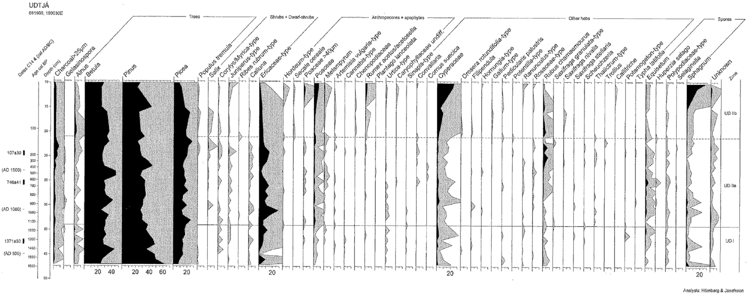
Pollen percentage diagram for Udtjá. From left to right: 14C dates and cal. AD ages within parentheses; interpolated ages from the calibrated 14C ages BP; depths in centimetre; microscopic charred particles (>25 µm); pollen and spore types as percentages (black shading) and at 10× magnification (grey shading). The solid line at c. 1130 BP indicates the boundary between the pollen assemblage zones UD I and UD IIa, which correspond to the pre-cultivation and cultivation phases, respectively. The dashed line at c. 110 BP between UD IIa and UD IIb indicates the onset of permanent cultivation. Herb pollen types only recorded once and at one level have been omitted.
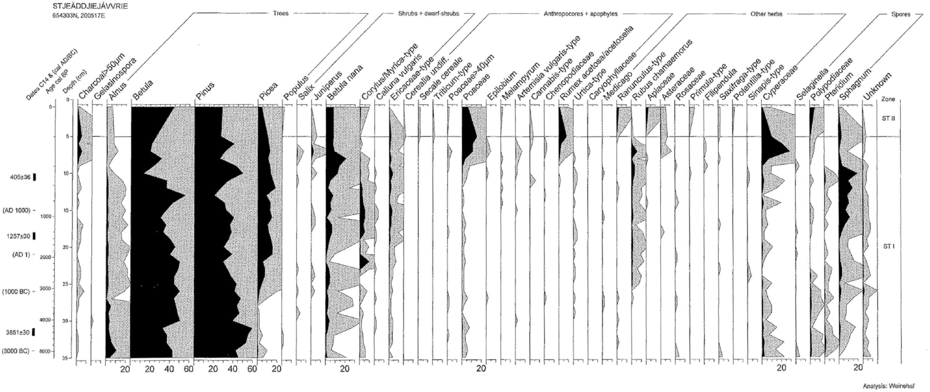
Pollen percentage diagram for Stjeäddjiejávvrie. From left to right: 14C dates and cal. AD/BC ages within parentheses; interpolated ages from the calibrated 14C ages BP; depths in centimetre; microscopic charred particles (>50 µm); pollen and spore types as percentages (black shading) and at 10× magnification (grey shading). The solid line at c. 200 BP indicates the boundary between the pollen assemblage zones ST I and ST II, which correspond to the pre-cultivation and permanent cultivation phases, respectively. Herb pollen types only recorded once and at one level have been omitted.
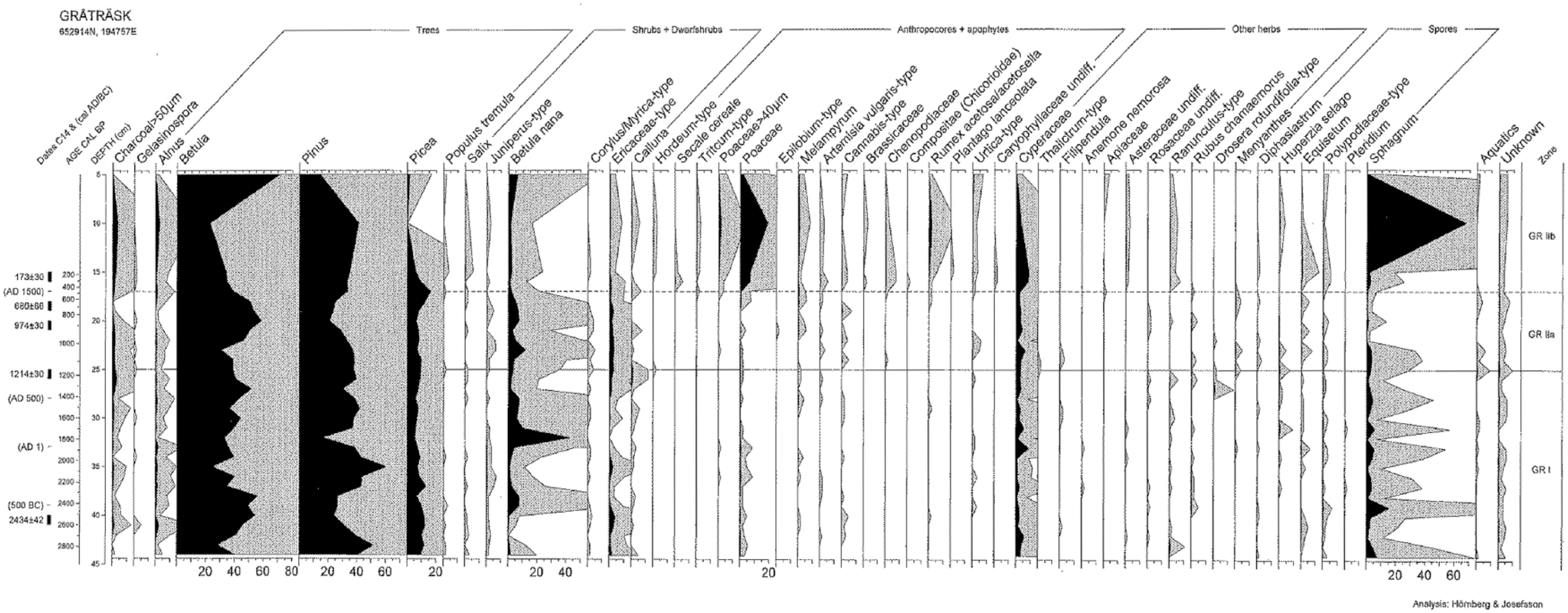
Pollen percentage diagram from Gråträsk. From left to right: 14C dates and cal. AD/BC ages within parentheses; interpolated ages from the calibrated 14C ages BP; depths in centimetre; microscopic charred particles (>50 µm); pollen and spore types as percentages (black shading) and at 10× magnification (grey shading). The solid line at c. 1140 BP indicates the boundary between the pollen assemblage zones GR I and GR IIa, which correspond to the pre-cultivation and cultivation phases, respectively. The dashed line between GR IIa and GR IIb at c. 470 BP indicates the onset of permanent cultivation. Herb pollen types only recorded once and at one level have been omitted.
Major changes in vegetation composition in the local PAZs in Udtjá, Stjeäddjiejávvrie and Gråträsk.

Dates (BP and AD/BC) are calibrated ‘best’ weighted averages of the ages from the age–depth model.
The signs of shifting cultivation and permanent cultivation indicated by cereal-type pollen and calculated from the interpolated age–depth models (Blaauw, 2010) for the three study sites (BP and AD).

Values in parentheses indicate ‘best’ weighted averages of the ages from the age–depth model.
Discussion
This study shows that low-intensity land use has occurred at Udtjá, Stjeäddjiejávvrie and Gråträsk for a very long time (Figures 3–5). Based on the presence of specific assemblages of apophyte and anthropochore pollen, our results suggest that shifting cultivation was practised sporadically and on small scales from around AD 800 (700–890) at Udtjá and Gråträsk and that permanent cultivation was established in approximately AD 1480 (1400–1560), AD 1750 (1720–1810) and AD 1840 (1725–1940) at Gråträsk, Stjeäddjiejávvrie and Udtjá, respectively (Table 4). This implies that the land-use history at these settlements was far more complex than suggested by our second working hypothesis. The presence of apophyte pollen types before and after the first sporadic occurrences of cereal pollen indicates a mix of low-intensity land uses. However, our interpretation of shifting cultivation is based on a few numbers of cereal pollen where the oldest grains identified were single occurrences of Hordeum-type pollen. The interpretive value of such stray finds of cereal pollen can be ambiguous; it has been argued that they neither verify nor discount local cultivation (Behre, 2007; Segerström, 1990). The cereal pollen we recorded were classified as Hordeum-type because they exhibited exine sculpturing and protruding pores in accordance with criteria established on the basis of a local grass pollen collection (Hörnberg et al., 2014) and on the basis of descriptions provided by Vorren (1986). The wild grass Leymus arenarius (syn. Elymus arenarius), whose pollen is similar in size to Hordeum, is exclusively found on sandy sediments that are not present in the studied areas. Furthermore, the first records of Hordeum-type pollen from AD 800 in Udtjá and Gråträsk coincide temporally with the oldest objects in the large metal find that was made just south of Gråträsk (Zackrisson, 1984). In summary, these findings suggest intermittent small-scale shifting cultivation of Hordeum in combination with other semi-permanent forms of land-use. Therefore, we suggest that the recorded Hordeum-type pollen is unlikely to be derived from sources other than local cultivation, although we cannot totally rule out other possibilities, including long-distance dispersal and contamination, presented by, for example, Behre (2007) and Lahtinen and Rowley-Conwy (2013).
Early land-use history
There is evidence that low-intensity land use was present in c. 4000 BP (2050 BC) at Stjeäddjiejávvrie, 2800 BP (850 BC) at Gråträsk and 1500 BP (AD 450) at Udtjá based on the presence of Artemisia vulgaris-type, Urtica-type, Cannabis-type, Rumex, Chenopodiaceae and Melampyrum pollen (Figures 3–5), all of which are widely used as indicators of early human impact in NW Europe (Behre, 1981, 1988; Hicks, 1988; Josefsson et al., 2009). These indicator plants may have become established in association with semi-permanent settlements sporadically used by hunter-gatherers and fishers and on sites that hosted small numbers of grazing animals. The presence of Urtica and Chenopodiaceae pollen indicates nutrient-rich conditions that probably arose due to ground fertilization with dung and urine, and the elevated levels of Poaceae, Melampyrum and Rumex acetosa or acetosella pollen are consistent with local grazing activities. These findings suggest that domesticated (or semi-domesticated) animals were present before AD 500 at all three sites. The finds of Artemisia vulgaris-type and Rumex acetosa or acetosella pollen are of particular interest since these species were used as medical and food plants by people in the northern part of Fennoscandia (Høeg, 1975; Qvarnström, 2006). Based on its relatively low abundance, the Cannabis-type pollen probably derived from hop (Humulus lupulus), a plant that has been recorded in the northernmost parts of Sweden during the early Holocene (Hörnberg et al., 2006). It was used and cultivated from AD 900 in NW Europe (Wilson, 1975), and during Medieval times in south-central Sweden (Emanuelsson and Segerström, 2002). Hop has also been used as a medical plant (Høeg, 1975). The Cannabis-type pollen may also derive from hemp (Cannabis sativa), an important prehistoric crop plant (Fleming and Clarke, 1998) that has been cultivated and processed at settlement sites in southern Sweden since BC/AD (Larsson and Lagerås, 2014). Hemp was retted in lakes (cf. Wallin and Segerström, 1994), and its fibres were used for making ropes, snares and fishing-nets. However, the Cannabis-type pollen identified in this work probably derives from hop because it is difficult to identify hemp retting based on pollen analysis alone (Odgaard, 1994), and retting is generally associated with high percentages of Cannabis pollen (Larsson and Lagerås, 2014; Regnéll, 1989). All in all, the land use during this early period seems to have been small in scale, varied and most likely intermittent rather than continuous.
Shifting cultivation from around AD 800
In both the Udtjá and Gråträsk cores, Hordeum-type pollen is first observed at around AD 800. Its appearance coincides with the presence of several pollen types associated with human activities (e.g. Urtica, Melampyrum, grasses, Juniperus, Cannabis-type and Artemisia vulgaris-type) and a slight increase in the abundance of charcoal particles (Figures 3 and 5, Table 4). These recordings indicate a change in land use at these two sites. Similar pollen assemblages have been found in samples dated to between 700 BC and AD 500 from places such as the Axlarp area in southern Sweden; they were interpreted to indicate cultivation with long fallow periods and fire clearances (Lagerås et al., 1995). The few finds of weed pollen, such as Chenopodiaceae, in the Gråträsk samples from this period also indicate shifting cultivation rather than manured fields (in which weed pollen is common). The relatively low percentages of grass and Hordeum-type pollen together with the high percentages of tree pollen in samples from this period are also consistent with low-intensity sporadic cultivation and stand in contrast to the much more pronounced changes in the abundance of such pollen types that were dated to c. AD 1300 in samples from central Sweden and linked to the introduction of slash-and-burn cultivation (Emanuelsson, 2001; Emanuelsson and Segerström, 2002). Signs of shifting cultivation only appear at one depth in the Gråträsk samples but Hordeum-type pollen occurs at three separate depths in the Udtjá cores, suggesting that cultivation at the latter site was sporadic and interspersed with lengthy fallow periods (Figures 3 and 5). This is remarkable because Udtjá is located in the far west of Sweden, in a traditionally Sami area with no historical documentation of cultivation before the early 1800s (Návsta, see Hultblad, 1968) or 1900s (Udtjá, see Manker, 1968). The first signs of shifting cultivation at Udtjá and Gråträsk appear with a level of synchronicity that is unlikely to be coincidental, especially since similar finds of scattered cereal pollen have been made at a small lake located just south-east of Lake Gråträsk (c. AD 600 uncal., see Karlsson, 2006), and in varved lake sediments from Lake Kroktjärn (dated to AD 750), which is located just east of the Lapland border near the village of Edefors and 83 km NNE of Gråträsk (Segerström, 1990).
Because cereal pollen, in general, and Hordeum-type pollen, in particular, exhibit limited dispersal (Segerström, 1991), shifting cultivation can only be detected by pollen analysis if the cultivated area was located in close proximity to the pollen sampling site (Overland and Hjelle, 2013). This suggests that our sampling sites were located close to areas where crops were handled or low-intensity shifting cultivation occurred (cf. Vuorela, 1973). Such cultivation sites were typically small, originally cleared by burning, and used only for a few years (Lagerås et al., 1995). In contrast, there is no indication of shifting cultivation in Stjeäddjiejávvrie (Figure 4). However, Melampyrum pollen appears recurrently in cores from this site while grass pollen, Urtica-type pollen and pollen from Chenopodiaceae were recorded sporadically at around AD 800, indicating an increased impact of grazing and trampling at Stjeäddjiejávvrie during this period.
Permanent cultivation from the late 1400s
From AD 1480 until the present day, pollen from different cereals (first Triticum-type, then Secale cereale and subsequently Hordeum-type) appears continuously in the Gråträsk core (Figure 5, Table 4). The percentages of other large-sized grass pollen also increased, as did those for Melampyrum, Rumex acetosa or acetosella, Artemisia vulgaris-type, Brassicaceae and Chenopodiaceae pollen (Figure 3). These changes indicate the introduction of permanent cultivation, manured fields, hay production and increased grazing. We suggest that permanent cultivation started in around AD 1480, that is, somewhat later than in Arnemark village c. 20 km upstream of the Pite River (Hörnberg et al., 2014) and Grandskogen at the outlet of the Pite River (Segerström, 1995). Importantly, this date is well before the first mention of farms at Gråträsk in the written historical records, which suggests that farming began at this site in AD 1543–1570 (Riksarkivet A, B, Table 1). While our results suggest that permanent cultivation at Gråträsk began in the late 1400s, the 2σ range of the calibrated date (Table 4) makes it difficult to exclude the possibility that permanent cereal cultivation may have been established around AD 1550, in accordance with the written historical sources.
Permanent cultivation at Stjeäddjiejávvrie appears to have begun in c. AD 1750 based on the occurrences of Triticum-type, Secale cereale and Cerealia undifferentiated pollen in the relevant samples (Figure 4). However, the calibrated ages of these samples have a 2σ range of c. 100 years, so the onset of permanent cultivation may have actually occurred at some point between c. AD 1718 and 1810 (Table 4). In addition, both charcoal particles and pollen from grasses and Rumex acetosa or acetosella became more abundant around this time, indicating the development of more open conditions and widespread grazing. However, only a few samples from the upper levels of the peat cores were analysed, making it difficult to explore these findings in more detail.
Permanent cultivation at Udtjá seems to have begun around AD 1840 based on the increased abundance of Hordeum-type and Secale cereale pollen in samples from this period (Figure 3, Table 4). Moreover, the presence of other pollen types such as Poaceae, Chenopodiaceae, Melampyrum and Rumex acetosa or acetosella in these samples indicates manured fields and grazing. The pollen record thus indicates that permanent cultivation at Udtjá began at an earlier point than is suggested by written sources for this site (Manker, 1968). However, the date suggested by the pollen records is consistent with that in the written records for the nearby settlement of Návsta (Hultblad, 1968; Sommarström, 1997). Thus, it seems probable that the people of Udtjá adopted permanent cultivation at about the same time as it was established in Návsta, although it should be noted that the calibrated ages of the peat samples in question have a 2σ range of more than 200 years, which makes it difficult to reliably date the onset of permanent cultivation (Tables 2 and 4).
New interpretations of early land use in the interior of northernmost Sweden
Our results indicate that low-intensity land use, possibly including animal herding, has occurred for thousands of years in the inland regions of northernmost Sweden. They also suggest that small-scale shifting cultivation may have been practised in the inland region as early as c. AD 800 in different environments, including areas where cultivation was formerly thought to be a very recent activity. Interestingly, our findings are consistent with those of several other studies that examined recordings of cereal pollen in areas with Sami settlements. For example; Cerealia-type pollen was identified in Abisko, Edefors and Åsele, dated to around 600 BC (Jankovská and Kociánová, 2010), AD 750 (Segerström, 1990) and AD 1000 (Segerström, 1982), respectively. Similarly, Hordeum-type pollen has been identified at Gieddeålge, where it was dated to AD 1350 (Staland et al., 2011); at Kartajauratj, where Secale cereale pollen was found and dated to AD 1400 (DeLuca et al., 2013); and at Munka where Cerealia undifferentiated pollen was dated to around AD 1600 (Josefsson et al., 2009). Together, these findings suggest a spatiotemporal pattern that is not consistent with the random effects of long-distance dispersal and instead indicates the presence of early small-scale shifting cultivation close to and west of the Lapland border. This in turn suggests the existence of a functional network of contacts in the interior of northernmost Sweden that enabled new ideas to be shared and encouraged the testing of new forms of land use alongside traditional usage patterns. In fact, given that signs of cultivation going far back in time have been found in northernmost Norway and Finland (for a review, see Josefsson et al., 2014), it seems unlikely that this form of land use was not similarly acknowledged and adopted in the interior of northernmost Sweden. Our results demonstrate a need for further archaeological surveys in areas where cultivation was previously assumed not to have occurred. Further investigations to identify macrofossil remains of cereal seeds and to gather more palynological data, including pollen accumulation rates (see, for example, Kuoppamaa et al., 2009) and non-pollen palynomorphs (Räsänen et al., 2007) from inland areas of northernmost Fennoscandia should also be conducted. This would make it possible to draw conclusions based on both pollen data and analyses of on-site finds and macrofossils (cf. Briggs et al., 2006).
Conclusion
The earliest records of Hordeum-type pollen in our study coincide with the presence of several pollen types associated with human activities, and they derive from around AD 800 (Udtjá and Gråträsk) – a dating that temporally coincides with the oldest objects in the large metal find that was made just south of Gråträsk. However, single occurrences of cereal pollen recorded at one site alone cannot verify early shifting cultivation in the interior of northernmost Sweden. Still, within this region, there have been several studies where such single occurrences of cereal pollen have been recorded. Together these early finds form an interesting pattern that opens up for a broad discussion on pre-historical land use in the inner parts of northernmost Fennoscandia. We believe that the traditional view of early Sami land use must be reconsidered and that it was more complex than has been previously acknowledged. It follows that traditional views on coastal farmers’ land usage might be equally simplified and biased and that ways of thinking based on simple terms such as ‘nomadic herders’ and ‘permanent farmers’ are inappropriate; indeed, they may hinder efforts to interpret and evaluate the complexity of land-use history.
Footnotes
Acknowledgements
We would like to thank Anna Weinehall for analysing one of the peat cores and Mari Kuoppamaa and two anonymous referees for their constructive comments and improvements to the text. The language has been corrected by John Blackwell at Sees-editing, UK.
Funding
This study is part of the research programme ‘Recalling the Past’ financed by the Bank of Sweden Tercentenary Foundation, grant no. M11-0361:1.