



Abstract
The Michoacán–Guanajuato Volcanic Field is the largest subduction-related monogenetic volcanic field in the world and includes more than 1000 scoria cones and a few hundred medium-sized volcanoes. Although medium-sized volcanoes (domes and shields) are less abundant, hazards associated with the renewal of this type of activity should not be neglected. Here, we focus on El Metate volcano, the morphologically youngest shield of the field. This volcano has a minimum volume of ~9.2 km3 DRE, and its viscous lava flows were emplaced during a single eruption over a period of ~30 years covering an area of 103 km2. El Metate is thus best labeled as a monogenetic andesite shield. This eruption had a significant impact on the environment (modification of the hydrological network, forest fires, etc.), and hence, nearby human populations probably had to migrate. New C14 dates for the eruption yield a young age (~AD 1250), which briefly precedes the initial rise of the Tarascan Empire (AD 1350–1521) in this region. By volume, this is certainly the largest eruption during the Holocene in the Trans-Mexican Volcanic Belt, and it is the largest andesitic effusive eruption known worldwide for this period. Such a large volume erupted in a relatively short time bears important implications for evaluating future hazards in the Michoacán–Guanajuato Volcanic Field.
Keywords
Introduction
During the Holocene, eruptions in the Trans-Mexican Volcanic Belt (TMVB) have occurred mainly at large strato-volcanoes (e.g. Popocatépetl, Volcán de Colima, Ceboruco) and in the Michoacán–Guanajuato Volcanic Field (MGVF). Volcanism in the MGVF (Figure 1) started ~5 Ma ago (Guilbaud et al., 2012) and is still active today as documented by the historic eruptions of Jorullo (1759–1774) and Paricutin (1943–1952). The MGVF is the region of the TMVB that contains the highest concentration of volcanic vents. It covers an area of 40,000 km2 and encloses >1000 small monogenetic structures consisting mainly of scoria cones, lava flows, and maar craters. In addition, there are ~400 volcanic edifices described as medium-sized volcanoes (Hasenaka, 1994; Hasenaka and Carmichael, 1985) and only two strato-volcanoes (Patamban and Tancítaro), both believed to be extinct since 200 ka (Ownby et al., 2006). Medium-sized volcanoes are larger in volume (0.5–10 km3) than monogenetic scoria cones (average 0.02 km3) but considerably smaller than strato-volcanoes (<50 km3; Hasenaka, 1994). Most of the medium-sized volcanoes are described as shields because of their low slope-angle and are assumed to be predominantly effusive (Hasenaka, 1994; Roggensack, 1992). After the initial work of Hasenaka (1994), these volcanoes have been labeled as Mexican shields because unlike typical shields made of thin basaltic flows, they are mainly andesitic and have slope angles of 5–15°, similar or higher than Icelandic shields. Most are older than Holocene and hence do not display pristine lava flow surfaces. Instead, they are frequently covered by fallout from nearby scoria cones, alluvium, and well-developed soils. The eruptive style that produced the Mexican shields (e.g. purely effusive or partly Strombolian) and their monogenetic or polygenetic nature remain under debate. Also, their potential impact on the local environment and relevance for hazard assessment have not been addressed so far.

Digital elevation model of the Michoacán–Guanajuato Volcanic Field (MGVF, outlined in red) showing the location of El Metate shield volcano. Yellow rectangle indicates the study area shown in detail in Figure 3. Monogenetic cone and medium-sized volcano database modified after Hasenaka (2009, personal communication). Inset map at lower right corner shows location of the MGVF within the Trans-Mexican Volcanic Belt (TMVB).
Humans have continuously inhabited the territory of the present State of Michoacán since at least 3500 yr BP (appearance of Zea pollen in Lake Pátzcuaro sediment cores), when populations large enough to modify the natural environment by agriculture are first recorded (Watts and Bradbury, 1982). According to Beekman (2010), in Michoacán, the early and middle Formative periods (2000–300 BC) of Mesoamerican archaeology document the earliest sedentary populations in this area. Later, during the late Formative and Classic periods (300 BC–AD 500/600), small village societies and ceremonial centers appear in the entire region, a pattern that continues through the Epiclassic (AD 500/600–900) and early/middle Postclassic (AD 900–1350) with increased population growth. From AD 1350 onward (late Postclassic), dramatic changes take place and the Pátzcuaro lake basin (located 36 km ENE of El Metate; see Figure 1) becomes the political core of the Tarascan (or Purépecha) Empire (Pollard, 1993) with intensified agriculture, centralized economy, and urbanization of major settlements (e.g. Tzintzuntzan, Ihuatzio; see Figure 1). This development comes to a rather abrupt end in the early 1530s with the conquest by the Spaniards and subsequent decimation of the indigenous population (mostly by European-introduced diseases, among other causes).
The role that volcanism in this region might have played in influencing pre-Hispanic human development (as outlined above) has never been addressed. Considering the abundance of young volcanoes in this region, it is reasonable to expect that volcanic eruptions had a dynamic effect, in particular in regard to triggering population migrations. The lack of sufficient archaeological records does not allow us to properly evaluate the impact of volcanic eruptions on the pre-Hispanic populations of Michoacán, but the historical eruptions of Jorullo (1759–1774) and Paricutin (1943–1952) demonstrate the significant social and environmental alterations that even such small eruptions can produce (Guilbaud et al., 2009). For example, the eruption of Paricutin lasted 9 years during which a total volume (lava and ash) of 2 km3 was emitted (Fries, 1953). When the eruption came to an end, it had destroyed two villages, caused the mobilization of >4500 people, buried 24.8 km2 of land under lava, and covered 300 km2 by >15 cm of ash (Luhr and Simkin, 1993). Although the eruption of a medium-sized volcano has never been witnessed in Michoacán in historical times, it certainly would have a much larger impact than the small Strombolian-type eruptions of the Paricutin and Jorullo scoria cones.
In this paper, we focus on El Metate, the morphologically youngest shield volcano in the MGVF. We report new radiocarbon dates that confirm and constrain its young age. Our volume estimate allows us to conclude that its eruption was the most voluminous of the Holocene period in the entire TMVB. Future avenues of archaeological research that might help understand population migrations derived from such sudden local environmental changes are outlined. Finally, based on the extraordinary volume and remarkably young age of this eruption, we underscore the importance of re-evaluating volcanic hazard and risk in the MGVF: future hazard studies should not only include scoria cones but also consider mid-sized volcanoes, such as El Metate shield.
Location
El Metate volcano (N 19°32′19″, W 101°59′34″, 2910 m a.s.l.) is situated at the margin of the so-called Meseta Tarasca, a highland that forms the core of the MGVF (Siebe et al., 2014). Its summit is only 14 km NNE of Uruapan (the second largest city in the Mexican state of Michoacán), 30 km E of Paricutin, and 15 km NW of the archaeological site of Tingambato (Figure 1). When traveling from Uruapan to Paracho, it is impossible to overlook the steep 200-m-high front of one of its lava flows that looms impressively over the village of Capácuaro (Figure 2). We chose this volcano for our study because it has been recognized as the youngest medium-sized volcano in the entire MGVF (Hasenaka, 1994; Hasenaka and Carmichael, 1986). In addition, its remarkably well-preserved morphology (Figure 3) permits a detailed investigation of lava flow emplacement mechanisms (results will be addressed in a separate paper).
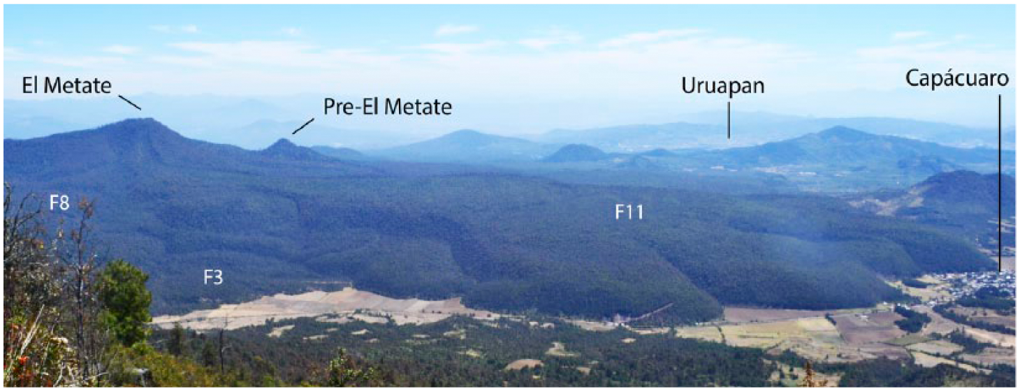
Panoramic view of El Metate (2910 m a.s.l.) from the summit of Cerro Paracho (3340 m a.s.l.). Different lobes of the ~200-m-thick F11 lava flow (see also Figure 3) are clearly discernible.

Digital elevation model of El Metate shield volcano showing emplacement sequence (1–13) of the different lava flows. Sampling points of rock samples and paleosols (radiocarbon dating) are indicated.
Methods
The outlines of El Metate’s lava flows as well as other related features were first mapped with the aid of aerial photographs, Google Earth satellite images, topographic maps (1:50,000) from the Instituto Nacional de Estadística, Geografia e Informática (INEGI), and a shaded digital elevation model (DEM) at a 20-m horizontal resolution built using ArcView Geographic Information Systems (ArcGis).
Ground truthing was then undertaken during several field campaigns in 2014 and early 2015, totaling 6 weeks. We first explored all roads (including unpaved dirt tracks) in the surroundings of the volcano in order to confirm the limits of the entire edifice and systematically collect rock samples at lava flow fronts. With the aim of determining the chronological sequence of lava flow emplacement and collecting additional samples of each of the lava flows in areas near their source, we undertook several long hikes along lava flow contacts toward the summit. Few paths used by lumberjacks, stonecutters, and their donkeys are present. It was necessary to hire locals who guided us on arduous journeys (at times through thick underbrush) and uphill across forested rough lava surfaces to reach our goals. Despite an annual precipitation of >1500 mm, streams are absent on El Metate’s slopes because of a high infiltration rate, which is typical for such young and brecciated lavas. Instead, several high discharge springs occur at the front of the most distal lava flows (e.g. near Zirimícuaro; Figure 3). For these reasons, exposures displaying the lower contact of lavas are absent with the exception of two cuts created by the railroad works in the south (see description below, locations 14285 and 14286; Figures 3–5).

Stratigraphic sections showing paleosols exposed underneath El Metate lava flows and diverse pyroclastic deposits from which samples were obtained and dated by the radiocarbon method. Locations of these exposures are indicated in Figure 3.
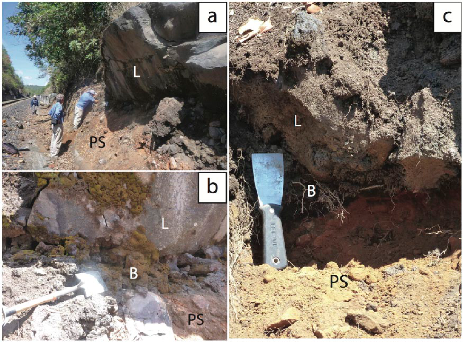
Photographs showing details of outcrop 14285, where one of the dated paleosol samples was collected. (a) General view of the railroad cut that was widened in recent years when the tracks were refurbished. (b) Details of the contact between the lava (L), the basal lava flow breccia (B), and the paleosol (PS). Shovel for scale (length = 70 cm). (c) Close-up of the excavated contact (spatula = 20 cm long, for scale) showing a truncated paleosol (PS) where the A-horizon is missing and only the Bw-horizon is exposed. The paleosol is friable, has a silty-loamy texture, and the moist sample is yellowish-red (color code 5YR 3/4 of the Munsell color chart). The sample responded positively to the allophane field test (Fieldes and Perrott, 1966) and hence presumably meets the requirements to classify as a silandic andosol (IUSS Working Group WRB, 2014). It is >1 m in thickness and contains ~30 vol% angular to subangular, up to 5-cm-sized clasts of older lavas.
In total, we collected more than 30 lava samples covering all identified flows of El Metate and surrounding volcanoes. Petrographic thin sections and chemical analyses (major and trace elements) were obtained from all samples, revealing an andesitic composition (SiO2 = 56–61 wt%). The three most representative analyses of El Metate and the nearby Hoya Urutzen scoria cone are listed in Table 1. Our full chemical data set will be presented elsewhere (Chevrel et al., submitted).
Major oxide (in wt%) and trace element (in ppm) analyses of rock samples from El Metate lavas, and ash fallout and other products from nearby volcanoes. Sampling points are indicated in Figure 3.

Volcano morphology
El Metate is composed of a central steep dome-shaped vent surrounded by lava aprons (Figures 2 and 3). The central dome (called Canacua ‘the crown’ in Purépecha) has a roughly symmetrical shape, a diameter of ~1000 m, a height of ~300 m, and steep sides (>30°). It was built by overflows of lava and has a horseshoe-shaped crater open toward the E, marking the outlet of the last lava discharge. Spatter deposits were neither found on the crater rim nor elsewhere. Relicts of an early vent wall are observable ~500 m to the NE of the central dome, suggesting that the emission source migrated slightly during the eruption. The lava flows are distributed radially around the summit dome area. The lava apron is not perfectly symmetrical because the volcano was emplaced on an inclined terrain sloping 2–5° to the S. Accordingly, the longest lava streams flowed downslope in this same direction, surrounding preexisting small edifices. Among these, an older structure dated at 1416 ± 42 ka (for details describing the 40Ar/39Ar technique employed, see Guilbaud et al., 2011) can be seen protruding from the surrounding flows (Figures 2 and 3). To the N and to the W, distal lava flow surfaces are almost horizontal and end forming an abrupt flow front. Although the lava flows are covered by pine forest, only an incipient thin silty soil has developed over their irregular blocky surface. Blocks range from few decimeters to several meters in size. The morphology of the flows is well preserved: lobes, pressure ridges, fault channels formed by strain localization, lateral levees, and other features can easily be recognized on aerial images and allow to infer flow trajectories. We identified at least 13 distinct flow units, and the relative chronology of emplacement was assessed by the contact characteristics between the various flows and their compositional differences (Figure 3). The length of the flows (measured from the vent to the front) ranges from 3 to 15 km and the thickness varies from a few meters up to 200 m. The longest lava (F6) to the south is 15 km long, up to 2 km wide, and 70 m thick on average. The thickest lava (F11), one of the last emplaced, is fan-shaped. Near the summit dome, it first flowed down in a narrow channel, widened to 4 km after exiting it, and ended in a steep frontal snout shaped by lobes (Figures 2 and 3). The aspect ratio (Walker, 1973) of the lava flows could be defined for the entirely discernible lava units, F6, F7, F8, and F11 (Figure 3), and varies from 88 to 24.
Age of El Metate
In his study of the Paricutin area, Williams (1950) describes El Metate (which he refers to as Cerro de Capácuaro) in the following manner:
Although heavily forested, the lavas are free from all but a thin, patchy cover of ash. Hence they are younger than all the cinder cones in the immediate vicinity. Their surface features are so well preserved that it seems safe to say that the flows were erupted either within the present or the preceding millennium.
This assessment is in agreement with our own observations and experiences gained by working on numerous other volcanoes in the TMVB, located in areas with similar climate and weathering conditions, for example, in the Sierra Chichinautzin (Siebe et al., 2004). Hasenaka and Carmichael (1985, 1986) dated a paleosol (sample 761C) collected ‘just below El Metate tephra in a small stream cutting a little away from the lava front’ (Hasenaka, personal communication) by the conventional radiocarbon method at 4700 ± 200 yr BP. We dated the same paleosol at a nearby location (19°34′32.3″, 101°58′17.7″, 2309 m a.s.l.; see also Figure 3) and chemically analyzed the overlying 2-m-thick fallout tephra. We obtained an age of 3775 ± 50 yr BP (sample 1206; Figures 3 and 4 and Table 2) and discovered that the ash covering this paleosol is basaltic (analysis 1206-B in Table 1) and has major and trace element compositions that differ significantly from the andesitic El Metate lavas, suggesting a different source. The railroad tracks connecting Pátzcuaro and Uruapan cut El Metate’s southernmost early lavas exposing their base as well as the underlying paleosol. Two paleosol samples were collected directly under the oldest lava (F1) at two different locations lying 1 km apart from each other (19°28′28.0″, 101°57′06.0″, 1797 m a.s.l. and 19°28′27.3″, 101°57′40.4″, 1790 m a.s.l.; Figures 3–5). C14-dating by the accelerator mass spectrometry (AMS) method of the organic matter in the paleosol yielded ages of 840 ± 30 yr BP (sample 14285) and 740 ± 30 yr BP (sample 14286). The respective calibrated age ranges (2σ) overlap for the period encompassed by the decade AD 1250–1260 (Table 2). The ages are quite consistent within the limits of the method. According to our new dates, El Metate must have started erupting only ~280 years before the Spanish conquest in the AD 1530s. This means that El Metate is much younger than previously postulated by Hasenaka and Carmichael (1985), but within the age range estimated originally by Williams (1950).
Radiocarbon dates for the El Metate area, Michoacán.

N. r.: not reported.
Dates were obtained either on charcoal fragments or on paleosols (bulk organic matter) by the accelerator mass spectrometry (AMS) method at Beta Analytics (Miami, Florida) with the exception of sample PAZ-1206 (A-15894) dated by conventional radiocarbon dating at the University of Arizona by Chris Eastoe.
Conventional ages were calibrated using Calib 7.1 (Stuiver and Reimer, 1993; http://calib.qub.ac.uk/calib/calib.html). Half-life used is 5568 years.
In regard to the origin of the basaltic ash fallout, believed by Hasenaka and Carmichael (1985) to stem from El Metate, we conducted further fieldwork. From its thickness (200 cm), grain-size (coarse sand to lapilli), and scoriaceous and well-bedded nature, it must have originated from a vent located within a radius which should not exceed 5 km. We first assumed that the assessment of these authors was correct and that the ash might stem from an initial Strombolian phase of El Metate that built a basaltic scoria cone at the vent. This cone would today be buried under the thick andesitic lava flows emplaced later. In this case, the 1.4-Ma-old edifice (Pre-El Metate) that crops out ~1.5 km south of El Metate’s summit (Figure 3) should be covered by several meters of coarse ash. However, we only found a 70-cm-thick strongly altered scoriaceous ash fallout under a well-developed clayey soil (locality 14303; Figures 3 and 4). The paleosol underneath the altered ash yielded a radiocarbon age of 13,480 ± 50 yr BP (Table 2), which is in accordance with the degree of alteration of the ash, but predates significantly El Metate’s eruption. This finding further underscores our conclusion that the basaltic ash dated by Hasenaka and Carmichael (1985) at 4700 ± 200 yr BP and by us at 3775 ± 50 yr BP does not stem from El Metate. Further investigations took us to the Hoya Urutzen monogenetic cone, located 2 km SW of locality 1206 (Figure 3). This volcano grew on N-sloping ground and produced first a Strombolian cone and early lavas of basaltic and basaltic–andesite composition (analyses 15357 of early scoria bomb and 15358 of early lava) before turning fully effusive and emplacing andesite lava flows (analyses 1207, 14320, and 14330 in Table 1) that inundated the plains toward the N. About 1 km to the SE of Hoya Urutzen’s vent (localities 15337 and 15359; Figures 3 and 4), we found up to 200-cm-thick well-bedded ash fallout deposits that are basaltic in composition (analysis 15337; Table 1). The paleosol directly underneath locality 15337 yielded an age of 3650 ± 30 yr BP (Table 2), which is quite compatible with the age of 3775 ± 50 yr BP at locality 1206. From all of the above evidence, we have no doubt that the ash fallout dated at 4700 ± 200 yr BP by Hasenaka and Carmichael (1985) and by us at 3775 ± 50 yr BP at locality 1206 stems from Hoya Urutzen and not from El Metate, which was apparently emplaced in a solely effusive manner and did not produce any ash fallout. For this reason, it is neither crowned by a scoria cone nor documented by an ash layer in sediment cores from the lake basins to the east (e.g. Arnauld et al., 1997; Metcalfe et al., 2007; Newton et al., 2005; Telford et al., 2004).
Interestingly, the age of Hoya Urutzen’s ash fallout is comparable to a tephra layer identified in the sediment cores of lakes Pátzcuaro (sample C4/T404), Zacapu (sample CA1/T58), and Zirahuén (sample T3) that were dated at 3790 ± 50, 3800, and 4000 yr BP, respectively (Newton et al., 2005; Vázquez et al., 2010). Newton et al. (2005) correlated this tephra layer found in the lake deposits with the El Jabalí scoria cone situated 10 km SW of El Metate and dated at 3830 ± 150 yr BP by Hasenaka and Carmichael (1985). Our new dates for Hoya Urutzen volcano suggest that further studies need to be conducted to determine whether the ash layer in the lake cores truly stems from El Jabalí (as originally postulated by these authors) and not from Hoya Urutzen, which is in closer proximity to the lakes and could hence also be a likely source of this tephra layer. Our findings not only underscore the importance of further studying explosive eruptions that produced well-known stratigraphic ash markers in this region but also remind us of the intriguing role played by effusive eruptions (such as El Metate), that are stratigraphically undetectable in lake cores.
Volume estimate by reconstruction of the paleo-topography
After establishing the edifice boundary, the basal area of the volcano was calculated at 103 km2. The topographic relief before El Metate’s eruption was reconstructed interpolating the 20-m topographic lines (Figure 6), according to their most probable continuation using the surrounding topographic line patterns as a guide. These were then converted into triangulated irregular networks (TINs). The volume of the edifice was estimated using the surface difference tool of ArcGis that calculates the volumetric difference between the surface of the actual edifice and the paleo-surface. This method allows accounting for an irregular topography beneath the present edifice. Care was taken to avoid over-estimating the volume. By this procedure, the volume of the entire volcano was calculated at 10.8 km3 and then converted to dense rock equivalent (DRE) assuming that 5 vol% represents void space between the brecciated blocks of lava flow carapaces, and an additional 5–10 vol% represents vesicles within the lavas. The minimum volume for El Metate therefore ranges between 9.2 and 9.7 km3 DRE. It should be noted that the maximum volume of the volcano obtained without considering the paleo-topography but with a TIN interpretation assuming a near flat surface is 12.2 km3. On the other hand, Hasenaka et al. (1994) reported a volume of 16 km3 considering a perfect conical shape.

Digital elevation model of the El Metate volcano area showing (a) the present topography and (b) a hypothetical reconstruction of the topography before its eruption (~AD 1250). Note the size of the area (103 km2) covered by its lava flows and significant changes to the hydrological network after the eruption.
Volume comparison with other eruptions in Mexico and worldwide
The eruption of El Metate is outstanding when compared with the existing eruptive record for the Holocene in Mexico and also worldwide (Table 3). Its volume is significantly larger than any other known eruption in Mexico for this time period (Figure 7). It is almost five times larger than the monogenetic eruptions of Paricutin or Jorullo and two to five times more voluminous than outstanding Plinian eruptions known from Popocatépetl (e.g. Ochre Plinian Pumice) or Ceboruco (Jala Pumice). The volume of each single lava flow of El Metate is comparable in its order of magnitude to the volume of a single monogenetic scoria cone and associated lavas.
Known large-volume eruptions (explosive and effusive) for the Holocene in Mexico and elsewhere. Eruptions younger than 1000 yr BP are highlighted in gray and El Metate eruption in bold.

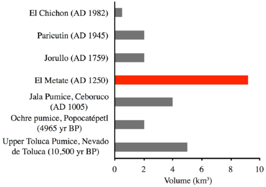
Volume-graph of well-known Holocene eruptions in Mexico showing that El Metate has been by far the most voluminous for this period.
During the last millennium, at a worldwide scale, El Metate is comparable by volume to the total magma produced by the most violent eruption of the last century in Central America – Santa María Volcano (Guatemala) in AD 1902 (8.5 km3; Williams and Self, 1983) – and to the most violent eruption of the last millennium in South America – Huaynaputina in Perú in AD 1600 (10–9.6 km3; Adams et al., 2001; De Silva and Zielinski, 1998). It is only surpassed by large caldera-forming eruptions in Indonesia such as Rinjiani in AD 1257 (>40 km3; Lavigne et al., 2013) and Tambora in AD 1815 (30–33 km3; Self et al., 2004) or by the eruption of Mount Katmai (Alaska) in AD 1912 (13 km3; Fierstein and Hildreth, 1992).
During the Holocene, effusive eruptions similar or larger in volume have occurred in Iceland and include Katla in AD 934 (19.6 km3; Thordarson et al., 2001) and Laki in AD 1783 (14.7 km3; Thordarson and Self, 1993) and in New Zealand at the Okataina volcanic center, where the 8050 yr BP Mamaku and the 5550 yr BP Whakatane eruptions produced volumes of 12 and 10 km3, respectively (Smith et al., 2006). But in the Americas, El Metate represents the most voluminous Holocene effusive eruption yet found, only surpassed by the late Pleistocene Chao dacite flow (23 km3; De Silva et al., 1994) in Chile. Besides, since Icelandic eruptions are basaltic and those in New Zealand rhyolitic, El Metate is the most voluminous Holocene effusive eruption of andesitic composition so far reported worldwide.
Using the relationship proposed by Pyle (2000), the magnitude of the eruption (= log10(erupted mass, kg) − 7) is estimated at 6.3 (similar to the Laki eruption). If the eruption at El Metate had been explosive, it would have a Volcanic Explosivity Index (VEI) of at least 5, which is considered a very large cataclysmic eruption (according to the classification of Newhall and Self, 1982). Fortunately (for human populations living nearby, see below), the chemical and physical properties of the magma, including its rheology (dependent on chemical composition, crystallinity, volatile content), ascent rate, and pre-eruptive degassing, prevented the magma from erupting explosively but produced instead a steady effusive eruption.
El Metate’s eruption style and edifice type: Monogenetic andesite shield
Unquestionably, the eruption style of El Metate was different from other typical monogenetic eruptions such as the 1943–1952 mixed violent-Strombolian/effusive andesitic eruption of Paricutin (Luhr and Simkin, 1993), the 1783–1784 effusive Laki basaltic fissure eruption in Iceland (Thordarson and Self, 1993), the rhyolitic single lava flow (coulée) eruption of Chao in Chile (De Silva et al., 1994), or the 1977 phreatomagmatic Ukinrek eruption in Alaska (Kienle et al., 1980). The eruption of El Metate was purely effusive and emitted several voluminous andesitic lava flows that built a shield of considerable height. Nonetheless, the morphological similarity of the well-preserved lava flows and the absence of soil horizons (temporal discontinuity) between flow units strongly suggest that they were produced in a relatively short period of time during the course of a single eruption. Although some time (months, maybe even years) could have elapsed between flows, all field observations indicate that the El Metate eruption can be labeled as monogenetic. Similar voluminous monogenetic shield volcanoes are found, for example, in Iceland, where Skalbreidur has a volume of ~10 km3 (Rossi, 1996) but is made of low-viscosity basaltic lavas. In contrast, El Metate is the first monogenetic shield recognized to be composed of multiple distinctive thick andesitic lavas. Not all Mexican shield volcanoes are of the same nature (purely effusive and monogenetic). Other reported examples of monogenetic shields (situated outside the MGVF) include La Laja (0.66 Ma/~10 km3) in the Atenguillo graben, state of Jalisco (Righter and Carmichael, 1992), and Dos Cerros (~14,000 yr BP/~1.2 km3) in the Sierra Chichinautzin (Agustín-Flores et al., 2011). The latter, besides being much smaller is crowned by two Strombolian cones and was hence not purely effusive. Polygenetic shields do also exist. For example, Paracho volcano (neighboring El Metate to the NW; Figure 3) is also considered a Mexican shield (despite having relatively steep slopes of 12–19°) and is clearly polygenetic (Siebe et al., 2014). Being the highest volcano in this area, it is remarkable by its steep protruding summit dome emplaced inside a cirque from which a deeply incised valley originates. We collected and dated a paleosol directly underlying a block-and-ash fan originated during or shortly after the emplacement of the current summit dome. C14-dating yielded an age of 12,280 ± 40 yr BP (locality 14258; Figures 3 and 4). This age contrasts with the K–Ar age obtained from a lava sample from the flank of the edifice that was dated at 0.06 ± 0.01 Ma by Ban et al. (1992). The age discrepancy strongly suggests that Paracho might be rather classified as a composite dome than as a monogenetic shield. The varying morphology and differences in the degree of preservation of lava flow surfaces observable at Paracho’s flanks also point toward multiple eruptions separated by geologically significant time spans. Another polygenetic example is El Estribo volcano on the shore of lake Pátzcuaro. It consists of an ~126-ka shield crowned by a cinder cone dated at 28,360 ± 170 yr BP (Pola et al., 2014). In conclusion, mid-sized volcanoes in the TMVB are difficult to classify and display considerable genetic and morphologic variability. For the sake of simplicity, El Metate can be labeled as a monogenetic andesite shield.
Duration of the eruption
The remarkably well-preserved lava flow morphology of El Metate allows making inferences in regard to the rheological properties of the lava flows and estimating their emplacement duration. Here, we apply two independent methods to estimate the emplacement duration of several flows. Both methods require as input parameters the average length, width, and thickness of the full flow and hence can only be obtained for the fully exposed lava flows F6, F7, F8, and F11. The first method is based on the relationship between the amount of cooling of the lava channel and the final maximum length assuming a certain lava advance rate (Pinkerton and Wilson, 1994). This method provides a first-order approximation of the average volumetric effusion rate, and hence, by knowing the total volume of the flow, the duration of the emplacement can be estimated. The second method, proposed by Kilburn and Lopes (1991), links the duration of the flow emplacement to its final dimensions and underlying slope, independently of effusion rate, lava intrinsic properties (viscosity, density), and driving forces (gravity). Further details on the methods are presented elsewhere together with a detailed discussion on the physical properties of such lava (Chevrel et al., submitted). The average duration obtained by the two methods suggests that El Metate’s lava flows were emplaced during the course of 1.6, 1.3, 2.0, and 6.7 years for F6, F7, F8, and F11, respectively. The effusion rates of these lava flows would therefore range between 5 and 50 m3/s. These estimates seem reasonable by comparison to more mafic Icelandic shield volcanoes for which effusion rates of 5–15 m3/s have been reported (Rossi, 1996) or to active andesitic flows (e.g. the lava effusion rate for Paricutin is given at 3.9 m3/s (Fries, 1953), and for the Lonquimay lava flow a maximum effusion rate of 80 m3/s and an average rate over the entire flow emplacement duration of 7 m3/s are reported (Naranjo et al., 1992)). Lower extrusion rates of <3 m3/s have only been reported for flows on the slopes of large strato-volcanoes (e.g. at Arenal, Wadge, 1983; or at Bagana volcano, Wadge et al., 2012). Therefore, considering the total emitted lava volume of El Metate (10.8 km3, non-DRE) and a reasonable eruption rate of 10 m3/s, the emplacement of the entire edifice would have taken at least 34 years. This estimate assumes that there were no pauses of activity between the emplacements of each of the different lava flows and that they erupted continuously and sequentially, one after the other. In this context, it is worth mentioning that the efficiency of the lava to retain heat might allow the flow to keep advancing for months (Manley, 1992) after the cessation of the effusion at the vent. Maximum emplacement duration of the volcano must have been less than ~275 years, the time that elapsed between the start of the eruption in AD 1250 and the arrival of the Spaniards in that region in the 1520s. By then, the lava must have been essentially cold, otherwise it would have been noticed and probably mentioned in early Colonial chronicles.
Impact on the local environment and archaeological implications
Considering its large volume (~9.2 km3), the El Metate effusive eruption had a relatively low impact if compared, for example, with the explosive Plinian eruptions of Popocatépetl (Siebe et al., 1996) characterized by the production of vast pumice fallout blankets, lethal pyroclastic flows, and extensive lahar flooding. Nonetheless, after ~30 years of activity, El Metate lavas occupied an area of 103 km2, which is four times larger than the area covered by the Paricutin lava flows (Luhr and Simkin, 1993). Much like today, this region was probably covered by a mixed pine and deciduous oak forest, which must have been destroyed beyond the limits of the lava flows because of the propagation of fires. Whether this particular area was inhabited at the time of the eruption (~AD 1250) is not clear, but our reconstruction of the topography indicates the former existence of several creeks (Figure 6). Of these, the one running N-S along a former valley floor that is today occupied by El Metate’s largest lava flow (Flow 6 in Figure 3) must have been perennial, discharging several m3/s. This favorable circumstance was certainly attractive for permanent settlement since it allowed for fishing and hunting, as well as agricultural activities all year around. Modifications of the drainage pattern (including changes in the temperature and composition of springs, etc.), in addition to the fears provoked by earthquakes and rumbling noises directly associated with the eruption process, must have induced migration of adjacent populations and their permanent relocation elsewhere.
Archaeological information in Michoacán is still sparse (e.g. Figure 7 in Pollard, 2011). Only 10 km east of El Metate (Figure 8) is the archaeological site of Tingambato (also called Tinganio ‘where the fire ends’, in Purépecha language). From the ruins of this ceremonial center, El Metate can be seen looming over the horizon. Unfortunately, radiocarbon dates were not reported from the excavation, which brought to light several temple platforms, a ball court, tombs, and pyramids (Lagunas-Rodríguez, 1987; Ohi, 2005; Piña Chan and Oi, 1982). Based on the ceramic styles and architectural features encountered, the archaeologists concluded that the site was inhabited during the Epiclassic period (Figure 9) and abandoned suddenly around AD 900. This estimated date significantly predates the timing of the eruption, but, curiously, the main pyramid of this complex directly faces El Metate, hinting that the eruption might have occurred before its construction. Evidently, more work, especially radiocarbon dating, is required in order to establish the exact chronology of events, the time of abandonment, and possible links to El Metate’s eruption.
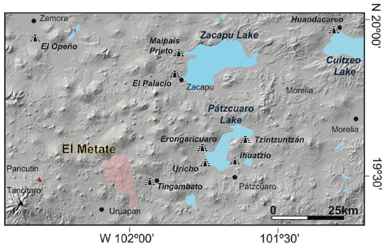
DEM showing El Metate volcano and its position at the western periphery of the core area of the Tarascan Empire around Lake Pátzcuaro. Important archaeological sites (mostly Postclassic) are indicated.
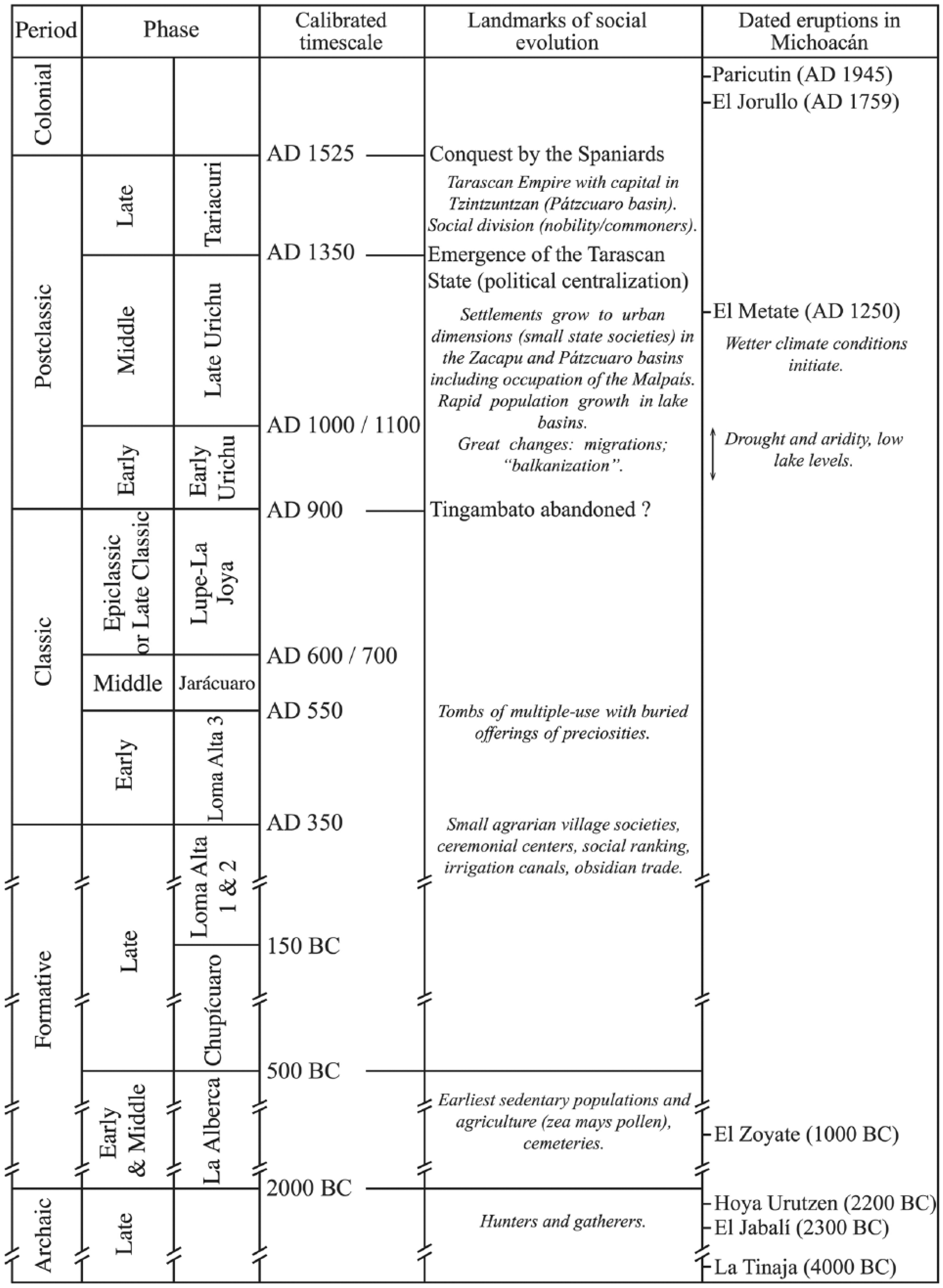
Chronological chart for north-central Michoacán showing the traditional Mesoamerican periods, local archaeological phases, and important social developments in Michoacán prehistory (mostly after Beekman, 2010; Fisher et al., 2003; Pollard, 2008). The timing of dated mid-to-late Holocene monogenetic eruptions in the MGVF is also indicated. Radiometric dates for volcanoes Hoya Urutzen and El Metate stem from this study, El Zoyate and La Tinaja from Guilbaud et al. (2012), and El Jabalí from Hasenaka and Carmichael (1985).
As mentioned in the introduction, the eruption of El Metate shortly predates the rise of the Tarascan Empire (Figure 9), whose power was centered at Tzintzuntzan on the NE shore of Lake Pátzcuaro (Figure 8) before the conquest by the Spaniards in the 1520s. Apparently, the initial consolidation of this empire occurred 270 years earlier at the western margin of the Zacapu basin (e.g. site El Palacio; Figure 8), where several settlements increased their population significantly in a short time and grew to urban dimensions after AD 1250 because of the sudden influx of immigrants that supposedly came from the north (Carot, 2013; Michelet et al., 2005). According to the Relación de Michoacán, an ethno-historic document that depicts the history and socio-religious organization of the Tarascans (compiled from oral traditions in 1541 by the Franciscan friar Jerónimo de Alcalá; De Alcalá, 2000), the newcomers (called uacúsechas) spoke the same language as the agriculturalists already settled there. They were guided to Zacapu by their main deity, Curicaveri. This god was subsequently elevated to the status of supreme deity. In this context, and given the temporal coincidence of El Metate’s eruption, it seems to us that it would be worth considering the possibility that at least some of these immigrants might have fled the areas affected by the eruption. Although El Metate is not located in the Bajío (Lerma river valley) to the north (where the immigrants supposedly came from), but to the SW in the Tarascan highlands (Figure 8), this closer location of origin would also be compatible with the linguistic and other cultural affinities that they shared with the people already settled in Zacapu (as described in the Relación de Michoacán). Maybe, some of the newcomers were originally refugees from a volcanic disaster who were seeking food and shelter with ethnically related friendly groups in the Zacapu basin. Such a migration scenario has been recently postulated for the rise and consolidation of the multi-ethnic city of Teotihuacan in central Mexico (Manzanilla, 2015). In this case, people originally dwelling around Popocatépetl and Xitle volcanoes (both near the southern boundary of the basin of Mexico) were forced to leave their homeland and found refuge in Teotihuacan, shortly after these volcanoes erupted ~2000 and ~1670 yr BP, respectively (Siebe, 2000; Siebe et al., 1996).
Modern production of grinding stones
Finally, it is worth mentioning that during fieldwork, we discovered that the upper area of the El Metate F12 lava flow (not far from the summit; Figure 3) is today still being quarried for the artisanal production of grinding stones (Figure 10), including metates (flat corn-grinding stones with a rectangular shape), molcajetes (mortars), and manos (pestles). This ancient craftsmanship is still carried out by few families in Turícuaro (Figure 3), a small Purépecha town at the NE foot of El Metate. In fact, the metates (this must also be the origin of the name of this volcano) from Turícuaro are regarded as of the finest quality in the entirety of Michoacán. Interestingly, most lava rocks do not meet the ideal requirements for these traditional kitchen tools, which need to combine a certain porosity and texture of the material together with sufficient hardness. Only certain types of fine-grained vesicular andesites can be called zakápu amákiti or ‘good stone’. In consequence, a 3-h uphill walk to the quarry areas is necessary. According to West (1948), metates have been manufactured in Turícuaro at least since 1822. Judging by the large areas covered by dm-thick layers of stone-cutting debitage (today mostly overgrown again by vegetation, including large pine trees), this activity might go back to pre-Hispanic times. If so, our chemical and mineralogical database could be used in the future for matching purposes with stone artifacts unearthed at late Postclassic archaeological excavation sites in order to determine their exact provenance (as attempted in other regions before, e.g. Bostwick and Burton, 1993). According to local informants, 100 years ago practically every family in the village made metates and molcajetes, but since the introduction of engine powered mills in mestizo and larger indigenous towns, demand for new metates has sharply declined. Hence, Turícuaro near El Metate might be one of the last remaining places were the craftsmanship of these kitchen tools used in the Mexican domestic environment since pre-Hispanic times could be studied before its final extinction in the foreseeable future.
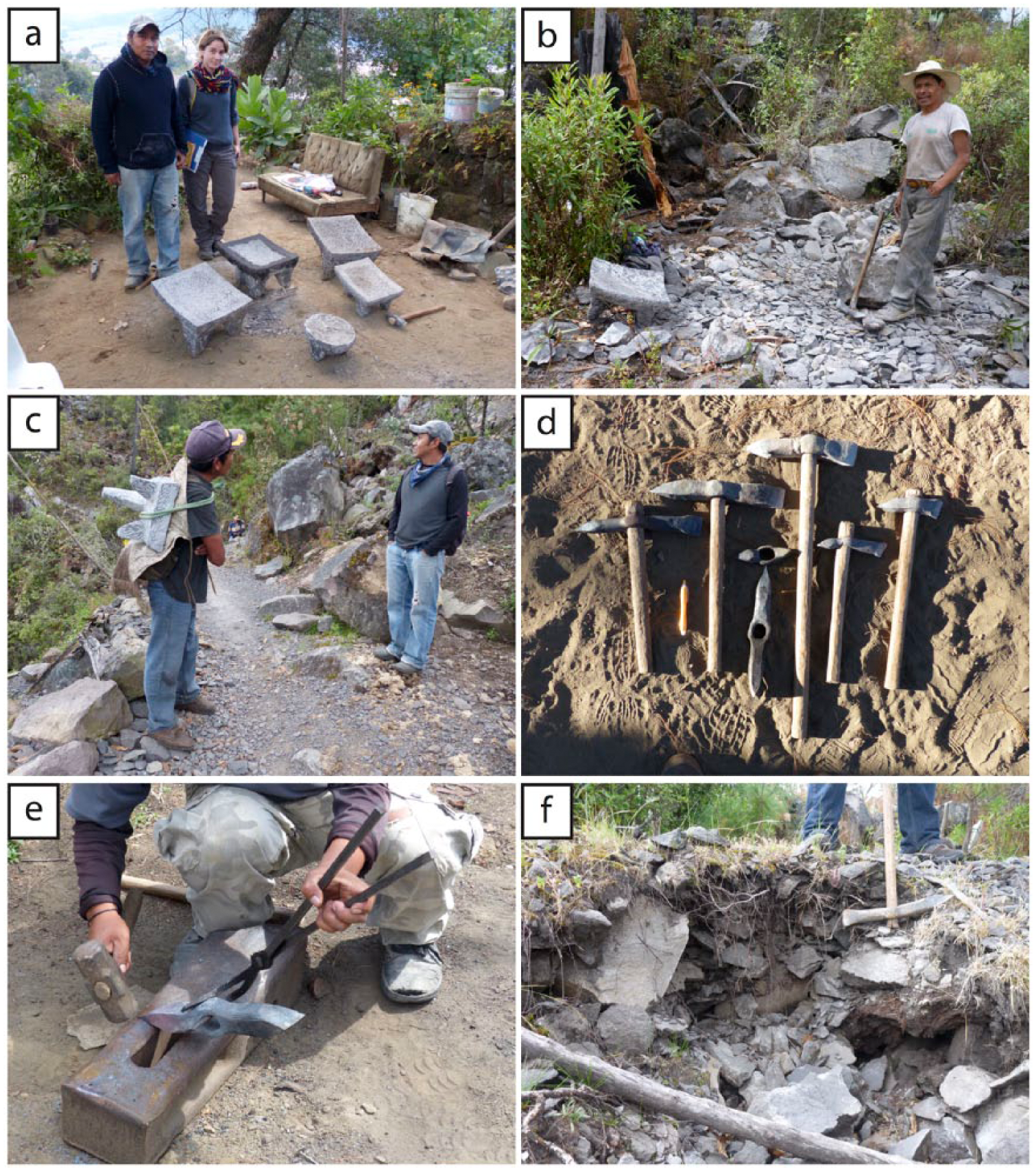
(a) Metates (iauári in Purépecha language) and molcajetes (súmatakua) carved by Nicolás Vidales (L) from fine-grained El Metate andesite (zakápu amákiti or ‘good stone’) at Turícuaro to the NE of El Metate volcano. (b) The raw material is quarried and roughly shaped near the summit of the volcano (also named Kanákuaráni or Cerro de la Corona) and then (c) carried down to town for finishing in the stonecutter’s house. Stone is worked with (d) an assortment of steel tools, for example, the pick (píkua) and sledge hammer (píkuak’éri), and is finished with a polishing stone (janámu). (e) Forged steel tools are also made locally at the workshop. (f) Over the centuries, large areas on the volcano have been covered by dm-to-m thick layers of quarrying debris, and in many cases, the surface has already been regrown by vegetation.
Future volcanic hazards in the MGVF
Hasenaka (1994) estimated the total magma output rate in the southern part of the MGVF for the last 1 Ma at 0.7 km3/ka. Of this rate, 0.23 km3/ka corresponds to scoria cones and 0.47 km3/ka to medium-sized volcanoes. Medium-sized volcanoes have therefore played a considerable role in the formation of the MGVF, and as mentioned above, the impact of an eruption like El Metate must have been substantial. During the 18th century, the population in Michoacán increased more than fivefold (McCaa, 2000) and the population density today has reached 74 inhabitants/km2 (INEGI, 2012). Recurrence of such a voluminous eruption (covering >100 km2) would generate tremendous disruptions. Given that ~400 medium-sized volcanoes erupted during the last 4 Ma in the MGVF (area of 40,000 km2), one volcano of this type was born on average every 10 ka per 100 km2. The young age of El Metate is therefore comforting, as it seems to indicate that there is still time ahead before the next eruption of this size occurs. However, the predictability of monogenetic eruptions in the MGVF has yet not been established. Furthermore, the exact recurrence of this type of eruption lacks precision because most of the volcanoes have so far not been dated. In order to determine with more accuracy the overall magma output rate as well as the eruption frequency, detailed geologic mapping and radiometric dating are still needed. For example, Guilbaud et al. (2012) provided an accurate map of the Tacámbaro area (SW of El Metate) and calculated an average eruption recurrence interval of 800 years with an average eruption rate for this region of 0.008 km3/ka/100 km2. Evaluation of future volcanic hazards needs to be based on similar work for the entire MGVF and also consider the medium-sized volcanoes as a potential threat.
Conclusion
El Metate is certainly the youngest Mexican shield volcano in the MGVF. Radiocarbon dating of two paleosols encountered directly below a lava flow yielded calibrated ages that overlap in the AD 1250s. Our field observations indicate that El Metate was built during a single eruption and hence is monogenetic. We estimate that the eruption duration was relatively short (probably ~34 years, certainly not more than 275 years), but took longer than for the formation of a typical monogenetic cinder cone. El Metate is the most voluminous (9.2 km3 DRE) eruption in Mexico during the Holocene and ranks among the most voluminous documented eruptions during this period worldwide. Furthermore, it is recognized here to be the most voluminous Holocene effusive eruption of andesitic composition so far reported.
The eruption had a considerable impact on the local environment. It covered ~100 km2 with thick viscous lava flows that changed the configuration of the hydrological network and probably initiated forest fires. Such a conflagration would have forced local human populations to migrate. The timing of the eruption coincides with the nucleation of people at sites located on the shores of nearby Zacapu and Pátzcuaro lakes at a time that corresponds to the initial consolidation of the Tarascan state (AD 1250–1350). Hence, the eruption of El Metate could have contributed to the processes that led to the rise of the Tarascan Empire, which flourished in AD 1350–1530.
Also of archaeological interest is the fact that some of El Metate’s lavas became one of the prime sources of raw material for the manufacture of grinding stones (metates and molcajetes) in Michoacán. This artisanal tradition is still alive in the Purépecha town of Turícuaro and probably goes back to pre-Hispanic times.
Finally, this study shows that the monogenetic eruption of a large-volume medium-sized volcano can have a significant impact on its surroundings. Hence, the recurrence of such an eruption (although much less likely than the formation of a small scoria cone) should also be considered in future hazard assessments in central Mexico.
Footnotes
Acknowledgements
The authors thank T Hasenaka (Kumamoto, Japan) for discussion and kindly providing his database on MGVF volcanoes as well as information on his radiocarbon sampling location. Archaeologists Z Lagunas-Rodríguez, G Pereira, C Fisher, and H Pollard helped in obtaining bibliographic information on different Tarascan sites. The authors thank Christina Siebe for helping them in characterizing paleosols. An anonymous reviewer and Aleksander Borejsza kindly reviewed the original manuscript and provided constructive criticism and valuable suggestions.
Funding
Field and laboratory costs were defrayed from projects funded by the Consejo Nacional de Ciencia y Tecnología (CONACyT-167231 and 152294) and the Dirección General de Asuntos del Personal Académico (UNAM-DGAPA IN-101915 and 105615) granted to C Siebe and M-N Guilbaud. MO Chevrel was funded by a UNAM-DGAPA postdoctoral fellowship (2014–2016). Nicolás Vidales and his family from the Purépecha town of Turícuaro were helpful during fieldwork and introduced us to the art of sculpting metates and molcajetes.