



Abstract
A detailed, high-resolution, pollen record conducted on Holocene sediments from Tell Sukas provides an advanced picture of landscape evolution and vegetation dynamics between 6000 and 2600 cal. BP (ca. 4050–650 BCE) in coastal Syria (core TSII). We report a prominent and abrupt increase in Olea pollen content and a coeval decrease in other arboreal essences at 4600 cal. BP, reflecting an intensification of olive horticulture in coastal Syria which is probably contemporaneous with the development of olive oil production in Northern Levant and an increased influence of human activities on vegetation dynamics. Highest abundances of Olea pollen (up to 60%) occurred between ca. 3900 and 3600 cal. BP at Tell Sukas, suggesting that the region became an important olive oil producer. However, the 4200 cal. BP increase in regional dryness widely reported in the Eastern Mediterranean coincides only with a slight decline in olive exploitation in Northern Levant, suggesting that milder conditions prevailed in coastal Syria. Conversely, the abrupt decline of Olea pollen abundances during 3400–3000 cal. BP along with increased values of semi-arid indicators and non-palatable herbs implies a significant drier climate, in accordance with other studies from the Levantine region. This is concurrent with the period of turmoil and crisis characterizing the end of the late Bronze Age and the transition to the Iron Age in the Eastern Mediterranean.
Keywords
Introduction
The Holocene is characterized by complex relationships between climatic changes, human activities and landscape evolution. Gradually through time, human activities have become the primary factor affecting landscape dynamics. This pressure is predominantly expressed by agriculture practices, which starts almost 11,000 years ago in the Near East (Sanlaville, 2000). Numerous archaeological sites show variations in the type of human occupation. Still, one main challenge in Holocene environmental records is to decipher the influence of climatic change on environmental dynamics and human activities. This issue is hampered by the relative paucity of available palaeoenvironmental records in the Eastern Mediterranean. High-resolution Holocene records from the Middle East are rare and often debated (e.g. Finné et al., 2011; Robinson et al., 2006). The Levant is positioned at a crossroad between three continents (Europe, Asia and Africa) and can be separated into three latitudinal sub-regions: (1) Southern Levant, which roughly covers Israel, Jordan and Palestine; (2) Central Levant, at latitudes of Lebanon; and (3) Northern Levant (Syria and South East coastal Turkey), which covers an area ranging from the piedmont of the Taurus to the Homs gap and from the coast to the Euphrates valley (e.g. Geyer and Braemer, in press). Recent palynological research works focused on natural lakes in Southern Levant: the Dead Sea (Langgut et al., 2014; Litt et al., 2012), the Sea of Galilee (Langgut et al., 2013), Lake Hula (Baruch and Bottema, 1999; Van Zeist et al., 2009) and the volcanic maar of Birkat Ram (Neumann et al., 2007a; Schwab et al., 2004). However, no natural lacustrine archive has allowed a comprehensive reconstruction of Holocene environmental change in Northern Levant yet, while very few coastal studies have been undertaken in Central Levant (Deckers et al. 2009; Hajar et al., 2010; Kadosh et al., 2004; Kaniewski et al., 2011; Verheyden et al., 2008). In Northern Levant, artificial reservoirs and old lacustrine sediment beneath farmlands occur in the Tell Nebi Mend plain (e.g. Homs Lake, Syria) and in the Ghab plain. Sediment archives from these environments were studied in the past (Niklewski and Van Zeist, 1970; Yasuda et al., 2000), but showed the difficulty in establishing a robust age model (Meadows, 2005). Palynological studies from the Jebleh plain (Syria) and Eastern Cyprus allowed the reconstruction of vegetation history in the Eastern Mediterranean, but only for the late Bronze Age (LBA; Kaniewski et al., 2008, 2010, 2013), while other recent works focused on the Ras Ib Hani peninsula (Goiran et al., 2015; Marriner et al., 2012). Hence, due to the difficulty to acquire high-resolution archives in Northern Levant, there is a gap in our knowledge regarding the sequence of environmental and climatic changes during the mid- to late Holocene in this region.
Here, we provide a new detailed palynological dataset covering the late Chalcolithic to the Iron Age (i.e. between 6000 and 2600 cal. BP; ca. 4050–600 BCE) in coastal Syria to document vegetation dynamics and climate fluctuations and, in particular, the emergence of olive horticulture in Northern Levant during the mid- to late Holocene.
In the Mediterranean realm, the olive tree is probably one of the most emblematic trees. It was the first fruit tree domesticated (Liphschitz et al., 1991), but a detailed record of olive tree exploitation is still lacking in Northern Levant; in particular, very few studies have tackled past trends of olive horticulture under the influence of rapid climatic change. Therefore, a challenge in this study will be to (1) refine the knowledge of olive tree cultivation and provide new data for Northern Levant and (2) to compare our results with other records from the Middle East. The sequence of regional environmental changes is explored in relation to the picture derived from archaeological data and historical sources, with the aim to gain a better understanding of human–climate interactions (including the development of agricultural practices) during recognized periods of large-scale Holocene climatic change. Specifically, it will be of utmost interest to evaluate whether correlations can be established between the culture of olive trees in Northern Levant, climatic changes as reported from other natural archives and a series of prominent societal issues: the end of the early Bronze Age (EBA) in the Near East (e.g. Weiss, 1982, 2014; Weiss et al., 1993) and the end of the LBA (e.g. Akkermans and Schwartz, 2003; Langgut et al. 2013; Litt et al., 2012; Neumann et al., 2007b; Ward and Joukowsky, 1992).
This research was undertaken and supported by the Syrian–French Archaeological Mission of Ras Shamra – Ougarit, headed by Valérie Matoïan and Jamal Haydar, and the ANR PaleoSyr/PaleoLib project, headed by Bernard Geyer, Frank Braemer, Philippe Sorrel and Jacqueline Argant.
Study area
Environmental and climatic setting
Tell Sukas (35°18′16″N; 35°55′22″E) is a coastal site in the Syrian lowlands, located between two natural harbours, 7 km southwards from Jebleh and 35 km from Ras Shamra (Northern Levant; Figure 1). The site, excavated by the Carlsberg Expedition to Phoenicia (1958–1963) was inhabited since the middle of the seventh millennium BCE. The artificial hill (24 m a.s.l.) was occupied more or less continuously from the Neolithic up to the end of the Hellenistic period (Lund, 1986, 2004; Oldenburg, 1991; Riis and Thrane, 1974; Riis et al., 1996; Thrane, 1978). Such a location enables a favoured agricultural exploitation with high water availability (Sanlaville, 2000; Weulersse, 1940) and makes this situation particularly convenient for trade and exchange between Inner Syria, Mesopotamia, Anatolia, Central and Eastern Mediterranean. However, the transition between the seashore and mountainous landscapes is rather abrupt along the Levantine coast. The Jabal an Nuşayrīyah (Alawite Mountains) stretches parallel to the coast and is regarded as the northern continuity of the Mount Lebanon. This mountain range reaches 1583 m a.s.l. and is mainly made of Cretaceous–Jurassic limestones (Hardenberg and Robertson, 2007). Along this rugged coastline, only three plains are suitable for a well-developed agriculture in the Northern Levant: the Akkar, the Jebleh and the Latakia plains. Tell Sukas, located in the Jebleh plain, is positioned in prime location for agriculture. Olive trees, vineyards and cereals have been the most important cultivated essences during the Antiquity (e.g. Zohary et al., 2012). Today, olive trees are mainly cultivated on the foothills of the Jabal an Nuşayrīyah. The perennial Nahr as Sukas River, originating from the piedmont 10 km eastwards, outflows in the southern bay of Tell Sukas. Pollen was transported to the coring site mainly by streams from the Jabal an Nuşayrīyah and katabatic winds.

Location map of Tell Sukas bay in coastal Syria (Northern Levant) and the coring position (red point) in the Southern bay.
A strong precipitation gradient crosses the country from West to East, generating a vegetation gradient through Syria from a thermo-Mediterranean formation on the coast to semi-arid vegetation assemblages to the steppe east of the Jabal an Nuşayrīyah. Average annual precipitation ranges from 700 to 800 mm yr−1 on the coast up to ca. 1400 mm yr−1 in the mountains, to less than 300 mm yr−1 in the arid margins eastwards from the Jabal an Nuşayrīyah and less than 100 mm yr−1 in the extreme East of the country (Traboulsi, 2004). At Tell Sukas, precipitation reaches 800 mm yr−1 with cold and wet winters due to the influence of the mid-latitude westerlies and hot and dry summers (with high atmospheric humidity) stemming from high-pressure systems centred over Iraq and Iran. The contrast between the rainy coast and semi-arid conditions to the East (e.g. in the arid margins) is related to the mountain range. The adiabatic gradient withholds humidity from the west and releases it as rain on the coast, creating a Foehn effect with hotter and dryer conditions to the eastern part of the mountains. Spatial and seasonal precipitation variations on the coast are controlled by temperature and pressure patterns of the Mediterranean sea surface (Sharon and Kutiel, 1986; Ziv et al., 2006). The Westerlies path and the extratropical, mid-latitude, winter cyclonic activity, which formed behind Cyprus (e.g. the Cyprus Low), account to a great deal to the annual rainfall and for major dust transportation to the Levant (Dayan et al., 2008).
Present-day vegetation
The distribution of the vegetation and associated phytogeographical belts depends on precipitation gradients and topography (Nahal, 1962; Pabot, 1957; Zohary, 1962):
The coastal Syrian lowlands belong to the Mediterranean plant geographical territory (Zohary, 1962) and is today to a high degree under arboriculture, horticulture and agriculture. The Mediterranean territory coincides mostly with the distribution of the olive tree (Olea europaea, Walter and Straka, 1970). Olea europaea is best adapted in its original natural habitat in the hill-country Mediterranean zones below 600 m a.s.l., although it can thrive in all regions submitted to the Mediterranean climate (Langgut et al., in press). Yet, olive orchards develop at best under 300–800 mm of annual precipitation, but can survive in under 200 mm of annual rainfall (Langgut et al., in press). Typical xeric elements of the steppe with desert scrubs and thorny-shrubs (Artemisia herba-alba, Ephedra fragilis, Juniperus oxycedrus, Noaea mucronata, Prosopis stephaniana, Sarcopoterium spinosum and Zizyphus lotus) are found in dry rain-fed spots, while trees/shrubs (Tamarix, Pistacia atlantica, Crataegus azarolus, Styrax officinalis and Ceratonia siliqua) are concentrated in the wet valley bottoms (Kaniewski et al., 2011);
Plant communities in the Jabal an Nuşayrīyah are mostly determined by orography, climatic and edaphic factors. At lowermost elevations (250- to 300 m altitude), the Ceratonia–Pistacia lentiscus association constitutes the natural vegetation (Niklewski and Van Zeist, 1970). Quercus calliprinos and Pistacia palaestina are also found in this zone. Between 250–300 and about 800 m a.s.l., the native Mediterranean Pistacia palaestina–Quercus calliprinos association (Horowitz, 1979; Kadosh et al., 2004; Weinstein-Evron, 1983) is the natural vegetation (Nahal, 1962), in which Quercus calliprinos represents the dominant tree (Niklewski and Van Zeist, 1970). In northwestern Syria, Quercus calliprinos is found up to an altitude of 1500 m, while Pinus brutia belongs to the natural vegetation on the western part of the Jabal an Nuşayrīyah, between ca. 300 and 800 m a.s.l. At elevations above 800 m, deciduous oaks are the dominant trees in the oak–Juniperus woodlands. Abies cilicica is present above 1150–1200 m a.s.l. (Nahal, 1962).
Material and methods
Coring site and lithology
A 420 cm-long TSII core (35°18′16″N; 35°55′22″E; altitude: 1 m a.s.l.) was collected using a percussion corer in the Southern bay of Tell Sukas (Figure 1). Retrieved directly from the beach, core TSII is mainly composed of sandy clays to clayey/silty sands, with occurrences of pebbles (Figure 2). From 420 to 210 cm, the lithology is homogeneous and dominated by clays. Sediments between 210 and 160 cm are mainly composed of silty clays, with progressive occurrences of fine sandy silts and pebbles between 160 and 105 cm. At 40 cm, coarse and well-sorted sands are indicative of proximal influences and document the slowing down of the late Holocene transgression along with the establishment of a beach facies (Figure 2).

Lithology and age model for core TSII based on four AMS 14C dating. The age model was built using Oxcal 4.2 (Bronk Ramsey, 2008; Bronk Ramsey and Lee, 2013). The model parameter k was set to 1 (or 100 m−1). The parameter k describes the relationship between the events and the overall stratigraphical processes – a high value for k would rigidly constrain the data and would be suitable for very simple sedimentary processes with little change in the sedimentation rate, whereas a low k value (such as in this study) would be the opposite (Bronk Ramsey, 2008). The average model agreement index (A model = 103.9%) is clearly above the critical threshold of 60% (Bronk Ramsey, 2008), indicating a robust result for this modelling.
Pollen analysis
Bulk sediment samples were taken about every 10 cm in core TSII, as often as possible in clayey and silty clay layers. A total of 36 samples, each consisting of about 10 g of bulk sediment, were treated for pollen analysis using a standard palynological procedure (Faegri and Iversen, 1989). Pollen grains were counted under 400× and 1000× magnifications. Pollen and spore identification was performed using pollen grain atlases (Reille, 1999) and the palynotheca of the UMR 5554 (University of Montpellier 2). For each sample, one tablet containing a known quantity of Lycopodium spore tablets (18,580 spores ± ca. 1000 per tablet) was added as exotic markers in order to calculate pollen grain concentration (Faegri and Iversen, 1989). Pollen concentration (including unidentified and undeterminable specimens) was calculated by the addition of Lycopodium spores (Bennett and Willis, 2001) according to the following formula:

All taxa identified are represented in the pollen diagram (Figure 3) except the taxa occurring with less than 10 pollen grains, which have been regrouped in ‘Other Herbs’ or ‘Other Trees’. Pinaceae regrouped all damaged pollen of Abies, Cedrus and Pinus sp.

Detailed pollen diagram for core TSII from Tell Sukas (Syria, Northern Levant). Pollen zones P1 to P3 were established based on a cluster analysis using the Past software. Ages are given in calibrated ages (cal. BP).
Numerical analysis
Pollen data were analysed using the Neighbour Joining (NJ) method (Figure 4). It is a method initially designed for reconstructing phylogenetic trees; it is based on the same principles as the cluster analysis method (Figure 3). NJ was computed using correlation as similarity measure and final branch as root in absolute data. Pollen types from each cluster were used to create pollen-derived vegetation patterns. ANOSIM analysis was also performed with the aim to define palynological zones (Figure 3). This method allows measuring the dispersion of samples versus the average of the group depending on the dispersion of the average between groups, which provides the significance of the clusters. A SIMPER analysis was further conducted on absolute data in order to extract the main contributor (e.g. taxa) for each group. This method then allows deciphering the most reliable taxa to infer changes in vegetation dynamics and environmental conditions.

Neighbour Joining (or NJ) analysis conducted on pollen data from core TSII and computed using correlation as similarity measure and final branch as root. A1, A2 and A3 are the reconstructed clusters for pollen-derived vegetation patterns.
Results and interpretations
Age model
For sediment dating, four AMS (Accelerator Mass Spectrometry) 14C dating were obtained on core TSII (Table 1). The use of radiocarbon dates from bulk sediments should in general be avoided because of reservoir and hard-water effects (Stuiver et al., 1998). Therefore, to avoid such shortcomings, AMS radiocarbon ages were determined using four charcoals, one juvenile marine shell and one palynological residue (Table 1). For each sample, AMS 14C dating was performed at the Poznań Radiocarbon Laboratory (Poland) and the Laboratoire de Mesure du Carbone 14 (CEA, Saclay, France) using at least 0.8 mg of pure extracted carbon. Using an online calibration program (Oxcal 4.2; Bronk Ramsey and Lee, 2013), the 14C ages were calibrated to calendar years by referring to the IntCal 13 terrestrial calibration curve of Reimer et al. (2013) for charcoal and palynological residues, whereas the Marine13 calibration curve was used for marine shells with a correction of reservoir effect of 400 years, corrected for Mediterranean samples (Reimer et al., 2013) (Figure 2). Instead of following a regular calibration procedure, a Poisson sequence deposition model (P Sequence; Bronk Ramsey, 2008) was chosen to build the age model (see also the caption of Figure 2 for more details). The advantage of this calibration is that it takes depositional condition changes into consideration. As illustrated in Figure 2, the age of core TSII spans approximatively 6000–2600 cal. BP (4050–650 BCE) and thus covers the late Chalcolithic period, the entire Bronze Age and part of the Iron Age (e.g. Iron Ages I and II). For intervals without radiocarbon dates, ages were assigned by a linear interpolation based on the age depth model. According to our chronology, the average sedimentation rate is ca. 0.065 cm yr−1. The average temporal resolution for the pollen analysis is estimated to 95 years per sample.
Radiocarbon dates for core TSII (Tell Sukas, Syria). Radiocarbon ages were converted to calibrated (cal.) ages using Oxcal 4.2 and CALIB Rev. 6.0.1. They indicate values with 2 standard deviation errors (95.4% of confidence level).
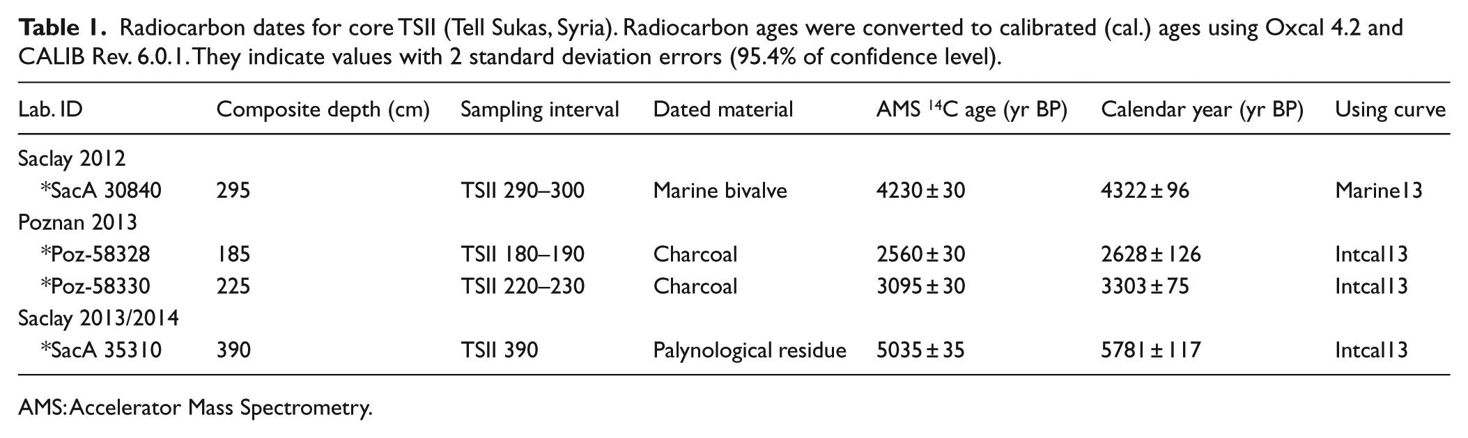
AMS: Accelerator Mass Spectrometry.
Pollen grain analysis
Pollen grains are abundant in core TSII, and pollen preservation is fairly reasonable in all the 36 samples analysed. Neither evidence of disturbed sediments nor dramatically corroded pollen grains were reported in core TSII. Pollen grains were generally well preserved in the grey silty clays typical of a shallow marine sedimentation. Conversely, pollen grains were rarely preserved in topmost sediments (e.g. from 161 cm onwards) because of oxidation in sand and beach ridge deposits; only two samples (83 and 79 cm) have delivered pollen grains for identification and counting. Dinoflagellate cysts and foraminifera linings were encountered in nearly every sample analysed, but were not investigated in this study. In total, 81 pollen taxa were identified. A total of 321 pollen grains were counted in average, except for a few samples in which pollen abundances were too low (>200 pollen grains, for 8 samples only). Pollen concentration calculated using Lycopodium spore tablets is high and generally stable: it varies from 8680 to 136,950 grains g−1 (48,811 grains g−1 on average; Figure 3) with noticeable peaks above 100,000 grains g−1 in zone P2 at 263 and 281 cm. Three ecostratigraphic pollen zones (P1 to P3) have been distinguished based on the major changes in pollen assemblages. Results are shown in a detailed pollen diagram (Figure 3), in which pollen taxa are depicted based on their ecological preferences. These ecostratigraphic pollen zones were further validated with a cluster analysis by applying the Bray–Curtis similarity measure (Faith et al., 1987) in paired group algorithm, using the ‘Past’ software. Ecostratigraphical zones P1, P2 and P3 are significant judging from an ANOSIM analysis (R = 0.841 and p < 0.001). A SIMPER analysis revealed that four taxa explain 50% of the total variance between P1, P2 and P3: Olea sp., Poaceae, Chenopodiaceae and Pinus. However, 80% of the total variance is explained when considering the following taxa: Asteraceae Cichorioideae (or Liguliflorae), Pinaceae, Asteraceae Asteroideae (or Tubuliflorae), Apiaceae, cereals, Quercus deciduous, Peganum harmala and Fabaceae.
Numerical results
Three main pollen-derived vegetation patterns were discriminated using numerical analyses: meadow and degraded environment, along with the cereal corpus (A1); olive tree corpus (A2); and Mediterranean woodlands and coastal steppe (A3). Subdivision into groups A1, A2 and A3 is reported with a strong confidence index (ANOSIM, R = 0.624, p < 0.001). In these three significant groups, subgroups can be deciphered using numerical analysis and ecological knowledge (Mouterde, 1983) (Figure 4).
A3
This cluster A3 can be divided into two subgroups (Mediterranean woodlands and coastal steppe; Figure 4). Mediterranean woodland is an arboreal association consisting of trees (Quercus, Pinaceae, Other trees) and herb taxa related to forest edges (Thelygonum, Euphorbiaceae, Other herbs). Mediterranean trees include mainly wind-pollinated trees, the most dominant in Northern Levant being the evergreen oak (e.g. Quercus calliprinos) and the deciduous oak (e.g. Quercus brantii, Quercus infectoria, Quercus ithaburens) (Mouterde, 1983; Tohmé and Tohmé, 2007). Pinus has a very good reproduction capacity as well as pollen dispersal and is over-represented in the pollen rain (Van Zeist et al., 2009). On the other hand, coastal steppe is characterized by Chenopodiaceae and Artemisia herba-alba. Chenopod pollen grains found at Tell Sukas most likely have two distinct origins: (1) from the shores, in the vicinity of the coring site, since Chenopodiaceae are usually halophytic and drought-resistant (Horowitz, 1992) and (2) typical xeric elements from dry rain-fed spots and gullies. We assume here that due to the predominance of anemophily, Chenopodiaceae may most likely stem from mid-distance transport and consequently the influence of chenopods should rather be regarded as a regional signal on the Western part of the Jabal an Nuşayrīyah. The wind-pollinated, xeric, taxon Artemisia is moderately well represented throughout core TSII. Artemisia is usually highly over-represented in the pollen rain (Baruch, 1993). In coastal environments from Northern Syria, Artemisia herba-alba is the only species identified (Kaniewski et al., 2011). The statistical proximity between Mediterranean woodlands and the coastal steppe hinges on the fact that they represent the natural vegetation. Hence, they should be interpreted in a different way than groups A2 and A1, which reflect a predominant anthropic influence (e.g. agriculture, degraded environment due to overgrazing, land use). Kaniewski et al. (2011) reported a similar proximity between Mediterranean woodlands and the steppic pollen-derived vegetation pattern, in opposition to the ‘cultivated’ association.
A2
This group is mainly characterized by Olea europaea and herb taxa. The olive tree occurs today in Northern Levant as both a cultivated and natural element (Zohary, 1973; Zohary et al., 2012). Although Olea pollen in the Circum-Mediterranean territory has a good production as well as dispersal of pollen (Ribeiro et al., 2005), we assume that a majority of the Olea pollen originates from the Western part of the Jabal an Nuşayrīyah. Moreover, abundances of Olea pollen often show a strong response to the cessation and resumption of orchard cultivation and are therefore regarded as a reliable marker for identifying agricultural activities (Langgut et al., in press). Olea sp. is statistically close to Caryophyllaceae and Apiaceae. Not far from this association, Urtica, Polygonum and Plantago lanceolata–type constitute a typical ruderal plant assemblage (e.g. anthropogenic indicators; Zohary, 1973). These plants are often associated with human-induced habitats. Other plants within this group include spiny Liguliflorae, Tubuliflorae (mainly thistles and different species of Centaurea which are all grazing-resistant plants – hence, higher values of these taxa may reflect a more intense human influence on the natural vegetation). No separate pollen type was distinguished within the Liguliflorae since the species included in this group show about the same ecological diversity as those of the Tubuliflorae. Dipsacaceae and Fabaceae are branched together and suggest a herbaceous association. Note also that Olea europaea is not associated with the well-known Oleaster phytosociological association of Cerastonion–Pistacion lentisci (e.g. Pistacia, Ceratonia, Quercus calliprinos; Horowitz, 1979; Kadosh et al., 2004; Langgut et al., 2011; Van Zeist et al., 2009). Hence, we assume here that occurrences of Olea pollen originate from the cultivated species.
A1
This group can be divided into two distinct environmental batches. First is the cereal corpus, made of Cerealia-type pollen (cereals) and Rosaceae (which are often associated; e.g. Kaniewski et al., 2011, 2013). If Cerealia-type pollen is distinguishable from other grasses based on size criteria (37 µm; Beug, 2004), it is not possible to discriminate wild from cultivated cereals from the pollen grains (Van Zeist et al., 2009). Hence, abundances of cereal pollen are of limited significance as anthropogenic indicator at Tell Sukas. Second, the meadow/degraded environment association contains open-land indicators consisting of different taxa (typically Sarcopoterium, Poaceae, Brassicaceae, Lamiaceae). Open-land herbs can originate from sparse maquis/forests, open fields and disturbed areas such as forest clearances and building sites (Langgut et al., 2014). Sarcopoterium is very common and typical from waste grounds; it is a degraded land bio-indicator (Tohmé and Tohmé, 2007) characteristic of the batha vegetation (e.g. a degradation stage of woodland and maquis; Van Zeist et al., 2009). Sarcopoterium is therefore associated with anthropogenic taxa (Litt et al., 2012).
To sum up, a first dissociation is evidenced between a human-impacted and a non-human, natural, environment (A1 + A2 vs A3). Olea europaea is associated with the herbaceous taxa, but surprisingly not with the usual oleaster arboreal association. Judging from the palynological data, we suggest that the prominent increase in Olea sp. pollen abundances at ca. 4600 BP (ca. 2650 BCE) documents the early stages of olive horticulture (or the initial management of olive tree crops) in Northern Levant:
The increase in Olea pollen content (2% to 40%) in P2 at ca. 4600 cal. BP (ca. 2650 BCE) is abrupt (Figure 3). Human contribution is expected to account for such a drastic change of vegetation and landscape dynamics.
Besides Olea europaea, no arboreal species characteristic of the oleaster forest was observed. In the Eastern Mediterranean region, the oleaster forms part of the Cerastonion–Pistacion lentisci association (Browicz and Zielinski, 1982; Nahal, 1962; Zohary and Orshan, 1959); however, none of these taxa are present in the samples.
Based on the NJ analysis, Olea europaea is far from other arboreal taxa (e.g. oaks) but close to Caryophyllaceae and other herbs (including ruderal plants).
The decrease in other tree abundances may reflect the impact of deforestation and a landscape opening for different purposes (e.g. horticulture, cereals, habitation, and/or wood exploitation).
Vegetation dynamics derived from the pollen record
Three ecostratigraphic pollen zones (P1, P2, P3) were depicted in the pollen diagram (Figure 3); palaeoecological association was mainly built based on numerical analyses. The palynological analysis documents vegetation history and dynamics in Northern Levant between ca. 6000 and 2600 cal. BP (ca. 4050–650 BCE), from the Chalcolithic to the Iron Age. Vegetation dynamics are discussed in terms of contrasting environmental states, in which major fluctuations of anthropogenic indicators versus natural Mediterranean vegetation can be detected in the pollen diagram. Periods evidencing a pronounced human impact (e.g. forest clearing, crop cultivation and/or occurrences of ruderal plants such as Plantago lanceolata) are depicted by high abundances of anthropogenic indicators on the natural vegetation, whereas periods of low human activity are characterized by an expansion of a well-developed Mediterranean forest/maquis in the area. It is worth quoting that the influence of local sedimentary processes on the pollinic signal can be neglected since no change of the river trajectory (which would stem from changing coastal morphology during the last 6000 years) was evidenced on the field. Hence, the deposition of fluvial-transported pollen in the bay of Tell Sukas reflects primarily the vegetation assemblages in the drainage basin, that is, from the Western part of the Jabal an Nuşayrīyah.
Zone P1: 406–310 cm (ca. 6000–4500 cal. BP/ca. 4050–2550 BCE); end of the Chalcolithic and first half of the EBA (EBA I, II and beginning of III)
In P1, the vegetal association is characterized by medium (and slightly increasing) abundances of evergreen and deciduous oaks along with elevated values of Pinus, most likely originating from the Mediterranean vegetation on the Western part of the Jabal an Nuşayrīyah. High percentages of Cyperaceae argue for the establishment of a marsh (associated with the lagoonal sedimentation). Cyperaceae was formerly recognized as a sensitive marker of fresh water input in coastal settings (Bernhardt et al., 2011, 2012). Poaceae (including cereals), Chenopodiaceae, Artemisia and Peganum harmala are also present in moderate values and point, together with the Mediterranean elements, to a sub-humid climate. Olea pollen abundances are increasing slightly towards the end of the zone, which probably reflects an early episode of olive cultivation in Northern Levant. We argue for a landscape relatively unaffected by human practices, showing, however, evidence for the development of olive horticulture at around 4600 cal. BP.
Zone P2: 310–218 cm (ca. 4500–3200 cal. BP/ca. 2550–1250 BCE); EBA III to LBA
The most striking feature in P2, apart from the marked decrease in Mediterranean tree values (especially those of Pinaceae), is the unprecedented rise of Olea abundances, for the first time reported at ca. 4600 cal. BP in Northern Levant. The remarkable increase in the olive tree curve reflects the spread of olive cultivation in coastal Syria rather than increased precipitation since the high distribution of olive was not accompanied by a coeval rise of other Mediterranean taxa. A similar pattern was reported in the initial late Chalcolithic in Southern Levant, although much earlier, at ca. 6300 cal. BP (ca. 4350 BCE) as based on palynological data (Baruch, 1990; Langgut et al., 2013, 2014, in press; Litt et al., 2012; Neumann et al., 2007a, 2007b; Van Zeist et al., 2009). Hence, the onset of olive exploitation at Tell Sukas in Northern Levant lagged by ca. 1800 years compared with Southern Levant – but this period is not represented in core TSII. The mid- to late Holocene pollen record of Tell Sukas yields reliable evidence for the beginning of olive tree cultivation at 4500 cal. BP, earlier than reported at Tell Tweini (ca. 4100 cal. BP; Kaniewski et al., 2010, 2012). Coastal environments in Northern Syria most likely had a crucial role in the early stages of olive orchard cultivation in Northern Levant, from the EBA onwards. It is worth remembering that the coring site at Tell Sukas bay is directly connected to the perennial Nahr as Sukas River, which drains the western part of the Jabal an Nuşayrīyah. Therefore, increased fluviatile input during seasonal floods (as well as during humid periods) should enhance pollen transportation within the bay, and thus, the abrupt increase in Olea pollen must be understood as a foremost regional, rather than local, change in the vegetation pattern. The decline in oak might be indicative of woodcutting in the foothills of the Jabal an Nuşayrīyah leading to landscape opening and deforestation for agriculture purposes. Part of woodcutting probably aimed at supplying local/regional use, while exportation is possible. Egypt imported wood from the Levant since the Predynastic period (Loffet, 2004; Sowada, 2009). Based on palynological data, it appears that favourable climatic conditions lead to a major step in olive cultivation through the early and middle Bronze Age in Northern Levant, in line with other reports from the Dead Sea in Southern Levant (e.g. Litt et al., 2012). In contrast, the subsequent centuries (e.g. 3450–3200 cal. BP/1500–1250 BCE) are marked by a prominent, sharp shrink in Olea pollen abundances, while olive horticulture was barely maintained around 3200 cal. BP. This period is also characterized by declining Poaceae values. At the end of zone P2, an important peak of Asteraceae Asteroideae occurs around 3200 cal. BP (ca. 1250 BCE) suggesting an abrupt degradation of coastal landscapes; this is coeval to elevated values of Peganum harmala and Chenopodiaceae, suggesting a relatively dry period in coastal settings at the end of the LBA.
Zone P3: 218–185 cm (ca. 3200–2600 cal. BP/ca. 1250–600 BCE); end of the LBA and Iron Age
P3 shows a prominent tipping point in the vegetation pattern with the collapse of olive tree cultivation and a marked increase in Tubuliflorae, Liguliflorae, Poaceae (including wild cereals) and Apiaceae, all indicative of drier environmental conditions in coastal Syria at 3200 cal. BP. Indeed, during the transition phase between LBA and Iron Age I (more particularly around 3200–3000 cal. BP), the proportions of all arboreal pollen drop dramatically to very low values which cannot be explained by human impact since olive, normally increasing during times of increased anthropogenic activities, is also strongly affected by this phenomenon. Therefore, this pattern most probably reflects an extensive drier period in northern coastal Syria, with the possibility of abandoned cultivated fields during droughts. Alternatively, pollen data show a conspicuous increase and continuous appearance (up to ca. 30–35%) of grazing-resistant plants typical of open-land landscapes (e.g. Liguliflorae, Tubuliflorae, Centaurea) during Iron Age I. Taphonomical studies on different pollen and spore types have shown that Liguliflorae pollen were more resistant to decay than other pollen species (Havinga, 1984). Hence, high percentages of open-land indicators (such as Liguliflorae) after ca. 3200 cal. BP (ca. 1250 BCE) might also be explained by differential preservation (e.g. overrepresentation) in this unit. Higher values of Pinaceae are also recorded during the Iron Age and precede a slight increase in deciduous oak pollen; in historical periods, pine was the first tree of the Mediterranean maquis to establish itself naturally in disturbed areas (Baruch, 1986, 1990; Lev-Yadun and Weinstein-Evron, 2002). Sarcopoterium spinosum also points to a degraded landscape.
Discussion
Between 4600 and 3600 cal. BP (2650–1650 BCE): the most important phase of olive tree cultivation during the EBA III–IV and Middle Bronze Age
Core TSII from Tell Sukas reports the most important increase in the Olea pollen curve at ca. 4600 cal. BP (2650 BCE), suggesting a marked rise of olive cultivation coevally to higher regional precipitation based on plant fragments from Tell Breda (Fiorentino et al., 2008; Figure 5c). Olive exploitation flourished in the following centuries, even peaking at very high levels (e.g. 60%) between 3900 and 3600 cal. BP (1950–1650 BCE) indicating that olive oil production attained its apogee during the middle Bronze Age. We propose to link the development of olive cultivation with the ‘second urban revolution’ (EBA III) (Akkermans and Schwartz, 2003), which corresponds to the full-fledged adoption of urban life in Northern Levant (Al-Maqdissi, 2010, 2012). Hence, core TSII from Northern Levant accurately documents the onset of olive exploitation in the middle of the third millennium BC already known in Southern Levant where early olive cultivation began around 6300 BP. In Southern Levant, the development of olive exploitation was associated with early urbanization processes during EBA I (Langgut et al., in press). Therefore, the increase in Olea pollen in core TSII documents the probable development of a specialized economy devoted to olive orchards and secondary products (olive oil). The specificity of Tell Sukas, as a coastal location receiving maritime humidity in Northern Levant, combined with the great agricultural potential of the Jebleh plain, may have stimulated the production of olive oil in coastal Syria. Reports of EBA olive stone remains at Tell Sukas (Helbaek, 1962) and the excavation of an olive press more to the North on the tell of Ras Shamra (Courtois, 1962) further corroborate palynological evidences which argue for olive tree cultivation. However, unlike Inner Syria (texts from Ebla: Archi, 1991), no text documented olive tree cultivation and olive oil production on the Syrian coast during the third millennium BC. It has been suggested that the Levantine ‘Combed Ware’ jars, classical marker of the EBA ceramic, were used for the storage of olive oil, even perhaps for its transportation (Mazzoni, 2002) although this was not confirmed by identification of olive and oil residue in jars. ‘Combed Ware’ was discovered on the North Levantine coast, at Shamiyeh (Al-Maqdissi and Ishaq, in press), Ras Shamra (Courtois, 1962 and unpublished fragments), Tweini (Vansteenhuyse, 2008), Sianu (Bounni and Al-Maqdissi, 1994) and Sukas (Oldenburg, 1991) and well-attested in the northern part of Central Levant, at Arqa (Thalmann, 2006), Fadous-Kfarabida and Byblos (Sowada, 2009; Thalmann and Sowada, 2014). In the Jebleh plain, numerous discoveries of ‘Combed Ware’ jars at Sianu (10 km from Tell Sukas) inferred that this city was probably a trade centre for olive oil production during the EBA III (Bounni and Al-Maqdissi, 1994). The production of olive oil was devoted to local consumption and possibly to trade exchanges. Although this hypothesis has not been confirmed by archaeological or textual data yet, two issues must be considered: (1) during the second part of the third millennium BC, Southern Levant experienced important socio-political changes (e.g. Finkelstein and Langgut, 2014) while (2) at the same time, maritime exchanges developed in Eastern Mediterranean and contacts reinforced between Egypt and Central Levant (Byblos) (Genz, in press; Grimal and Francis-Allouche, 2012). ‘Combed Ware’ jars represented the largest quantity of imported ceramics for the Old Kingdom (Sowada, 2009). Archaeometric studies have shown that some ceramics may have been produced in Byblos, while one vessel may originate from Northern Syria/Amuq (Sowada, 2009; Thalmann and Sowada, 2014: 372). Hence, it is all the more likely that Northern Levant benefited from this economic and cultural impetus and participated in the trade network. But yet, unlike Ebla in Central Syria (Scandone-Matthiae, 1997), no aegyptia dated to the third millennium BC have been discovered in secure EBA III levels on coastal Syrian sites (Matoïan, 2015).

Palaeoenvironmental records from Northern Levant and the Eastern Mediterranean: (a) pollen-based data from Tell Sukas (coastal Syria) in Northern Levant (core TSII; this study): Olea, Chenopodiaceae, Poaceae pollen data and the arboreal pollen (or AP) abundances; (b) Olea, Chenopodiaceae, Poaceae pollen data at Tell Tweini (coastal Syria; Kaniewski et al., 2010); (c) precipitation reconstruction based on δ13C of plant fragments from Tell Breda (Syria; Fiorentino et al., 2008); (d) the δ18O record from Jeita Cave (Lebanon; Verheyden et al., 2008); (e) Olea pollen content from the Dead Sea (Litt et al., 2012); (f) Olea pollen content from Lake Hula (Israel; Van Zeist et al., 2009). BC (Before Christ), BP (Before Present) and the archaeological period with EBA (Early Bronze Age), MBA (Middle Bronze Age) and LBA (Late Bronze Age). Grey shadings correspond to the three main periods discussed in this study, namely, the onset of olive cultivation at Tell Sukas, the end of the early Bronze Age, and the end of the (late) Bronze Age period.
Around 4200 cal. BP (2250 BCE), urban disintegration, changes in agricultural and cultural practices became widespread in many places from the Near East (Akkermans and Schwartz, 2003; Weiss et al., 1993; updated in Weiss, 2014), which corresponds to the collapse of the Akkadian empire (e.g. Kaniewski et al., 2008), the end of the Old Kingdom in Egypt (Stanley et al., 2003) and the abandonment of cities in western inland Syria (Schwartz et al., 2000). At the same time, a large-scale climatic event has been observed in the North Atlantic. The 4200 cal. BP (i.e. 4200–3800 BP) event (Bond et al., 1997, 2001) was documented worldwide in climatic archives (Mayewski et al., 2004; Sorrel et al., 2012). At low-latitude settings (such as in the Eastern Mediterranean), the 4200–3800 cal. BP interval corresponds to a notable increase in regional aridity (Bar-Matthews and Ayalon, 2011; Eastwood et al., 2007; Finné et al., 2011; Magny et al., 2013). In Southern Levant, Finkelstein and Langgut (2014) identified an interval with more arid conditions at the end of the early Bronze (~4000–3800 BP) in the Sea of Galilee, which is coeval to lower Dead Sea lake levels (Bookman et al., 2004; Kushnir and Stein, 2010; Migowski et al., 2006). Modelled precipitation estimation from Tell Breda (Syria) also inferred a decrease in regional precipitation (Fiorentino et al., 2008), whereas a prominent dryness beginning at 4200 cal. BP was reported from the Soreq cave record (Bar-Matthews and Ayalon, 2011). However, not far from Tell Sukas, the speleothem record of Jeita cave (Lebanon, Central Levant) does not show compelling evidence for a rapid climate shift around 4200 yr BP (Verheyden et al., 2008). Judging from pollen data in core TSII, the period centred around 4200 cal. BP is tied to a noticeable decrease in the Olea pollen curve, when drier conditions are reported at a large-scale in the arid part of the Levant. However, the effect of enhanced dryness on olive horticulture is not dramatic since Olea abundances remain at fairly high levels (e.g. 26%), therefore suggesting that olive exploitation did not drastically shrink during the 4200 cal. BP climatic event. Other palynological data tend to confirm the importance of olive trees in coastal Levant. Indeed, at Tell Tweini, a pollen grain study documented high Olea pollen content around 4100 cal. BP (Kaniewski et al., 2008; Figure 5). In addition, no dramatic event is reported from archaeological sites. We are therefore inclined to suggest that no ‘collapse event’ happened in the coastal part of Northern Levant around 4200 cal. BP. This is in accordance with the conclusions of Finkelstein and Langgut (2014), who suggested a shift to the North of the boundary between Mediterranean and Irano-Turanian vegetation zones at that time, thereby forcing numbers of people to move to the ‘greener’ parts of the Levant (e.g. the Northern Levant plains, including the Jebleh plain).
The late Bronze (ca. 3600–3200 cal. BP; 1650–1250 BCE) and the Iron Age (ca. 3100 to ca. 2600 cal. BP; 1150–650 BCE)
The LBA (from ca. 3600 to ca. 3200 cal. BP; 1650–1250 BCE) is marked by a spectacular decrease (from 60% to 5%, albeit in two steps: 3600–3500 cal. BP, then 3450–3200 cal. BP) in olive tree cultivation in Northern Syria around coastal Tell Sukas (Figures 3 and 6). Sukas (Suksi) is now mentioned in the texts of Ugarit as a town located near the southern border of the Kingdom of Ugarit (Lund, 2004; Van Soldt, 2005). Ugarit provides the main archaeological and textual documentation concerning olive horticulture in LBA Northern Levant. Olive press installations were discovered in different areas on the tell of Ras Shamra (Callot, 1994) and texts (13th and beginning of the 12th) documented olive orchards, production of olive oil in large quantities, as well as distribution and trade of olive oil (Heltzer, 1999: 446, 450). Olive horticulture thus represented the most important tree crop besides vineyards in the Kingdom of Ugarit. Hence, the end of the LBA and the transition with the Iron Age likely correspond to the most severe, abrupt decline of Olea pollen cultivation (along with a strong decrease in Mediterranean trees and an almost total absence of pollen grains in sediments) between 3250 and 3100 cal. BP (ca. 1300–1150 BCE), although the decline of olive exploitation already started at ca. 3450 cal. BP (1500 BCE). This relatively prolonged interval is, therefore, the most pronounced dry episode during the Bronze and Iron Ages in Northern Levant. A similar decrease – or persistently low values of Olea pollen (e.g. Langgut et al., 2013; Van Zeist et al., 2009) – in olive horticulture was reported in Southern Levant (Langgut et al., 2014; Litt et al., 2012; Neumann et al., 2007a) and in the Golan Heights (Neumann et al., 2007b). A dry episode during the LBA–Iron Age transition was well documented elsewhere in the Middle East (e.g. Carpenter, 1966; Ward and Joukowsky, 1992; Weiss, 1982), especially in palynological records from the Nile Delta (Bernhardt et al., 2012), the Dead Sea (Kushnir and Stein, 2010; Langgut et al., 2014; Litt et al., 2012; Migowski et al., 2006; Neumann et al., 2007a), the Sea of Galilee (Langgut et al., 2013) and Lake Hula (Van Zeist et al., 2009) in Southern Levant and from coastal Syria (Kaniewski et al., 2008, 2010) and Cyprus (Kaniewski et al., 2013), while harsher conditions in Turkey (Bottema et al., 1994; Woldring and Bottema, 2003) further suggested a dry spell spreading over a large geographical area. A former study that focused on the region of Tell Tweini, near Sukas (Kaniewski et al., 2008), concluded that a complex shift occurred from an open deciduous forest towards an arid/saline-tolerant vegetation at ca. 3175 cal. BP (1225 BCE). In western steppic Syria, an adverse drastic reduction in rainfall at ca. 3200 cal. BP (1250 BCE) was inferred at Tell Breda, concurrently to the precipitation trend proposed by Bryson and Bryson (1997) near Tell Leilan (eastern Syria). Other studies from the Eastern Mediterranean have documented a drier trend during the LBA–Iron Age transition (e.g. Drake, 2012; Roberts et al., 2011; Schilman et al., 2002). Modelled precipitation based on plant δ13C from Tell Breda (Fiorentino et al., 2008) and the δ18O speleothem record from Jeita cave (Verheyden et al., 2008; Figure 5d) has proposed that a dry trend started at ca. 3000 cal. BP. Coevally, lower rainfall is also inferred in carbonate deposits from Soreq cave (Bar-Matthews et al., 2003).
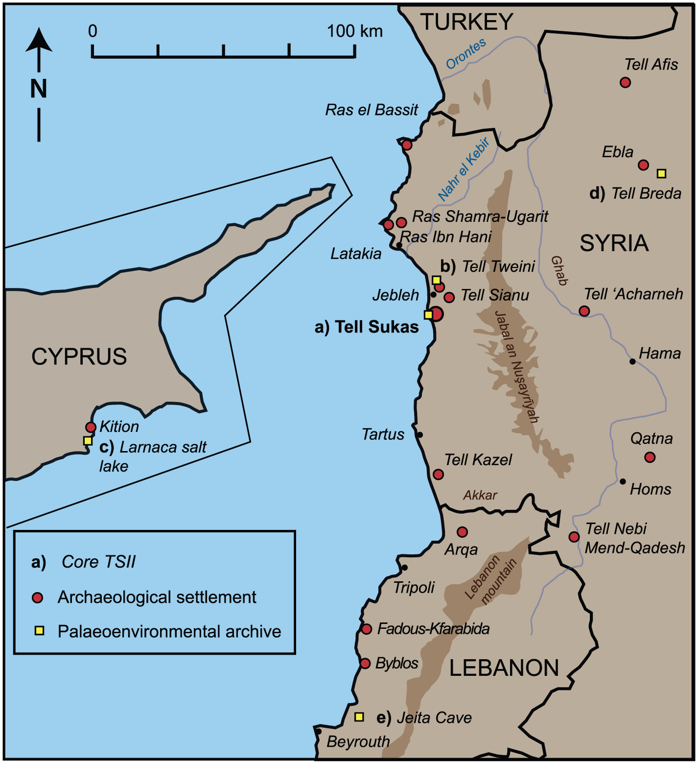
Map showing the archaeological sites mentioned in the text for Northern Levant and the palaeoenvironmental archives used in Figure 5 (e: Dead Sea and f: Lake Hula are outside of the map).
Here, we question to which extent the drier period widely recognized during the late Bronze–Iron Age transition could be related to the Near Eastern textual documentation dated to the 13th and 12th century BCE, which provides a vivid record of the desperate pleas for food in the Hittite empire (Bryce, 2005; Singer, 1999) and the Levant (Singer, 1999). The archives discovered in the so-called houses of Rapanu and Urtenu (Ras Shamra – Ugarit) are of special interest in this regard. Letters from the Hittite court, Pharao or the king of Qadesh documented demands for great quantities of grain and even famine (see RS 20.212, RS 34.152, RS 94.2002+, RS 94.2287; Lackenbacher, 2002; Lackenbacher and Malbran-Labat, in press; Singer, 1999). Moreover, as previous studies underlined, the question arises regarding a link between this dramatic climatic event and the period of turmoil and crisis of the end of LBA in the Eastern Mediterranean. Significant Aegean, Cypriot, Anatolian and Levantine centres (Figure 6), among which Ras Shamra (Yon, 1992, 2006), Ras el Bassit (Courbin, 1986), Ras Ibn Hani (Bounni et al., 1998), Tell Tweini (Bretschneider and Van Lerberghe, 2008), Tell Sukas (Lund, 2004; Riis et al., 1996), Tell Sianu (Al-Maqdissi, 2006) or Tell Kazel (Badre, 2006) suffered major destructions and the Hittite empire collapsed. However, the causes are still largely debated. Among other mechanisms, migrations, invasions of the Sea People, economic and social disintegrations or even environmental disasters, such as a dry event or earthquakes (Kagan et al., 2011; Nur and Cline, 2000; Oren, 2000; Ward and Joukowsky, 1992; Yasur-Landau, 2010), have been considered as proximate causes for the LBA collapse. On one hand, palynological data from core TSII corroborate the dry event occurring at the transition between late Bronze and Iron Age, with a dramatic shift in vegetation assemblages in coastal Northern Syria. At Tell Sukas, minimum values of Olea pollen were recorded around 3100 cal. BP (1150 BCE), thus inferring a weakening of olive oil production. On the other hand, the decline of the Olea pollen curve at Tell Sukas occurred around 3450 cal. BP (even at ca. 3600 cal. BP) at the time resolution used here, that is, long before the LBA collapse. Therefore, other factors (not documented in texts) must be considered for the decline of olive oil production as soon as about 3450 cal. BP (1500 BCE) in coastal Levant. Note also the increase in Tubuliflorae pollen abundances and low occurrences of Cyperaceae between ca. 3400 and 3150 cal. BP (1450–1200 BCE), all of which being indicative of a prolonged dry interval.
Tell Sukas was reoccupied at the beginning of the Iron Age (Riis et al., 1996). From ca. 3100 to ca. 2600 cal. BP (1150–650 BCE), pollen data from Tell Sukas suggest a climatic resumption with higher available moisture judging from increased values of oaks and cultivated olives and relative high abundances of Poaceae and Cyperaceae (Figure 3). Greater available moisture during the Iron Age was also reported from the Dead Sea pollen record in Southern Levant (Langgut et al., 2014; Litt et al., 2012; Neumann et al., 2007a) and from the Soreq cave (Bar-Matthews and Ayalon, 2011), probably because of increased precipitation in the entire Levant. Additionally, in core TSII, maximum values were recorded for cereals along with the spread of non-palatable herbs (e.g. the increase in Liguliflorae and Tubuliflorae), suggesting the onset of cereal agriculture from ca. 3100 cal. BP (1150 BCE) onwards, as it was also recognized in Southern Levant (Cordova, 2010; Litt et al., 2012). A slight increase in Olea pollen at 2600 cal. BP thus suggests a recovery of olive tree cultivation (e.g. Figure 3), even if our sampling resolution is too fragmentary in this interval. Nevertheless, olive orchards continued to be exploited after the long-term drought of the LBA–Iron Age transition, although the relatively low olive values are likely indicative that horticulture activity was primarily devoted to personal consumption, rather than for commercial purposes. Forthcoming analyses would be needed to help refine the history of olive cultivation on the Syrian coast from the Iron Age onwards (i.e. the time interval covering the Hellenistic, Roman, Byzantine and early Arab periods).
Summary and conclusion
For the first time in Northern Levant, a continuous, high-resolution, coastal sedimentary sequence of palaeoenvironmental changes is reported between ca. 6000 and 2600 cal. BP (ca. 4050–650 BCE) from Tell Sukas (coastal Syria). The study was conducted on core TSII from the fluvial-fed bay of Tell Sukas, which drains the western part of the Jabal an Nuşayrīyah; hence, the palaeoenvironmental reconstruction reflects mainly this region, not the coastal site strictly. High-resolution pollen data evidence prominent changes in vegetation dynamics in coastal Syria between the end of the Chalcolithic and the Iron Age which we propose to link to the picture provided from archaeological data. This study further extends (and improves) the Gibala–Tell Tweini lower resolution record, especially for the time interval 4100–3150 cal. BP (Kaniewski et al., 2008, 2010), and thus provides a benchmark for the environmental and climatic evolution in Northern Levant during the mid- to late Holocene.
A pronounced, abrupt, increase in Olea pollen abundances is recorded at ca. 4600 cal. BP in the region of Tell Sukas coevally with enhanced regional moisture, suggesting that olive horticulture greatly intensified at that time and became widespread on coastal Syria. This marked increase in olive tree cultivation is probably coeval with large-scale olive oil production during the early and middle Bronze Ages (with a peak of olive exploitation between 3900 and 3600 cal. BP; ca. 1950–1650 BCE). This study therefore provides a refined picture of olive horticulture activity in Northern Levant.
The interval centred on 4200 cal. BP (2250 BCE) has been reported as a period characterized by profound climate and political disruptions in the Middle East. Conversely, the palynological record of core TSII shows that coastal Syria is only slightly impacted by the increase in regional aridity and probably persisted as one of the main regions for olive oil production in Northern Levant. In contrast to harsher conditions in semi-arid areas from Southern Levant, coastal Syria may have benefited from milder climatic conditions, which favoured the development of olive exploitation. In contrast, much drier conditions are inferred from pollen data during the late Bronze–Iron Age transition, coevally with the collapse of Eastern Mediterranean LBA civilizations evidenced from archaeological and historical data. This transition features an abrupt decline in olive horticulture in Northern Levant.
Droughts in the Eastern Mediterranean region were tied to cooling periods in the North Atlantic for the past 55,000 years (Bartov et al., 2003), emphasizing the role of North Atlantic climate variability on Middle Eastern climate (Cullen et al., 2002; Kushnir and Stein, 2010) and thus on Levant hydrology. Recent studies have explored the links between dry/cold spells in the Middle East and North Atlantic cool events (e.g. Almogi-Labin et al., 2009; Langgut et al., 2011; Marino et al., 2009). However, the response of Eastern Mediterranean climate to high-latitude forcings is non-linear and complex (e.g. Kaniewski et al., 2008), thus appealing for further investigations, which necessarily require to be conducted at high resolution on relevant climate transitions of the late Holocene. In this regard, other independent sedimentary records, but also underexplored new sedimentary archives (e.g. mound springs, tufas, travertines; e.g. Rambeau, 2010), should offer valuable new insights to reconstruct climatic change in the Levant.
Footnotes
Acknowledgements
We profoundly and warmly thank Valérie Matoïan, Bernard Geyer and Frank Braemer for their very crucial contribution to this study. They deserve to be listed as authors as they helped considerably to improve the article during the entire process, and in particular in conducting the important archaeological contribution. We strongly thank the team conducted by Bernard Geyer, Nazir Awad, Jean-Philippe Goiran and Nick Marriner for coring on the field. We also gratefully acknowledge Gilles Escarguel for his valuable assistance and precious insights regarding numerical analyses.
Funding
This work was funded by Syrian–French Archaeological Mission of Ras Shamra – Ougarit and ANR PaleoSyr/PaleoLib project SHS3 (Grant/Award Number: ‘ANR PaleoSyr/PaleoLib project SHS3’).