



Abstract
The Transural steppe is a cultural contact zone between areas east and west of the Ural Mountains. Mobile pastoralism is the traditional way of life in the steppe, while sedentary cultures constitute an exception, probably as a result of climatic variations. A change of lifestyle together with other innovations is documented at the turn of the 3rd to the 2nd millennia BC and often believed to have been accompanied by a shift to agro-pastoralism. To examine the ecology and economy in the Bronze Age steppe, we employed a combination of methods. As proxy-data, plant macro-remains from archaeological excavations of Sintashta fortified settlements and pollen from off-site archives were used for a high-resolution palaeoenvironmental reconstruction. Statistical comparisons of past and present pollen spectra show no significant differences in vegetation distribution. This allowed us to map the recent vegetation units by multispectral satellite imagery and to use them for modelling. Models further incorporate steppe productivity, carrying capacity and population figures to estimate herd sizes. Even if the climate was suitable for agriculture, evidence is missing from all botanical records. The economic mainstay was animal husbandry. Models consider autonomous activity zones of at least 4 km radius surrounding each Sintashta settlement where grazing resources could easily sustain the estimated population and their livestock. The river is seen as the determining factor to settle in this region as it provided constant access to water and valuable natural grazing areas. During dry years and winter, the productive meadow steppes functioned as reserve pastures.
Keywords
Introduction
As a matter of principle, cereal cultivation is possible in the Eurasian steppes, but periodical droughts regularly lead to poor harvest or even crop failure which was experienced since the virgin lands campaign. The establishment of agricultural practices in the past was therefore not only a question of crop availability but required a profound knowledge of climate patterns and the steppe environment, especially on a localized scale, as well as a general willingness to take risks on behalf of the steppe dwellers. In the Transural steppe, a shift to a more sedentary lifestyle can be observed in the Bronze Age (Sintashta (-Petrovka) period 2100–1950 cal. BC (1σ)). Against this background, agro-pastoralism has often been controversially discussed as one of the subsistence strategies among Bronze Age societies in the Central Eurasian steppe (e.g. Boroffka and Mantu-Lazarovici, 2011; Epimakhov, 2010a, 2010b; Hanks and Doonan, 2009; Koryakova and Epimakhov, 2007; Ryabogina and Ivanov, 2011; Zdanovich and Zdanovich, 2002). Recent studies documented cultivation of free-threshing wheat (Triticum sp.), barley (Hordeum vulgare), broomcorn millet (Panicum miliaceum) and legumes in southeastern Kazakhstan and Turkmenistan in the 3rd and 2nd millennia BC (Frachetti et al., 2010; Spengler et al., 2014a, 2014b). A comprehensive overview of the spread of agriculture via the Inner Asian Mountain Corridor is given in Spengler (2015).
The Transural, situated at the periphery of the Eurasian steppe belt at the northern fringe of Central Asia (see Figure 1a and b), is predestined to be a zone of cultural contact, connecting areas east and west of the Ural Mountains. Accordingly, many hypotheses on the genesis of various cultures assume migrations to and from this area (see discussions in Bochkarev, 2010; Chernykh, 2008; Epimakhov, 2010a, 2010b; Koryakova and Epimakhov, 2007; Mei, 2003), often with the attempt to correlate linguistics and archaeology (see Anthony, 2013 and references therein). After the occupation of the forest steppe by local Eneolithic foraging–hunting–fishing groups and the sporadic occurrence of burials by Yamnaya cattle breeding people (3400–2300 cal. BC (1σ); Epimakhov, 2010b; Epimakhov and Mosin, 2015) in the southern Urals, there is a chronological gap concerning archaeological finds. At the turn of the 3rd to the 2nd millennia BC (2100–1950 cal. BC (1σ)), the Sintashta culture with fortified settlements, organized residential areas with rows of buildings, innovations in metallurgical and craft technologies such as spoke-wheeled chariots, as well as new burial rites appear in the Transural peneplain (Epimakhov and Krause, 2013). In terms of food supply, cattle bones dominate the osteological material, and one might expect that cereal cultivation was introduced as yet another response to climate change. As the general climatic patterns of the Bronze Age have been controversially discussed in the past, the adaptation of a sedentary lifestyle may either have been triggered by more humid conditions (Gayduchenko, 2002; Lavrushin and Spiridonova, 1999) or by increased aridity, since the latter required animal stabling during winter (Anthony, 2009). With pedological findings suggesting a humid climate, it was long assumed that vegetation belts were shifted southwards during the Bronze Age, implying the dominance of forests in the study area. On the other hand, some palynological investigations indicate a dry climate and a decline in woody vegetation (Kremenetski, 2003). So far, systematic archaeobotanical studies have only been carried out in neighbouring ecological regions, such as the forest steppe (Blyakharchuk, 2003; Krivonogov et al., 2012; Zakh et al., 2010), mountainous regions (Khomutova, 1995; Maslennikova et al., 2012) or the low hills of Kazakhstan (Kremenetski, 1997; Kremenetski et al., 1997), or have been restricted to cultural layers (Lapteva and Korona, 2013; Prikhod’ko et al., 2013; Ryabogina and Ivanov, 2011; Zakh et al., 2008), exacerbating a parallelization of results. Natural archives in the steppe that have remained undisturbed over longer periods of time have only been found in Mokhovoe, about 250 km east and 100 km north of the study area (Kremenetski et al., 1997), but the temporal resolution between 5000 and 1000 BC is too low to allow any detailed statements for the Bronze Age. The chronology, vegetation history and human–landscape interactions are still deficient for the southern Transurals owing to a lack of suitable archives and a low quantity of 14C-dates (for an overview of previous studies, see Stobbe et al., 2015).
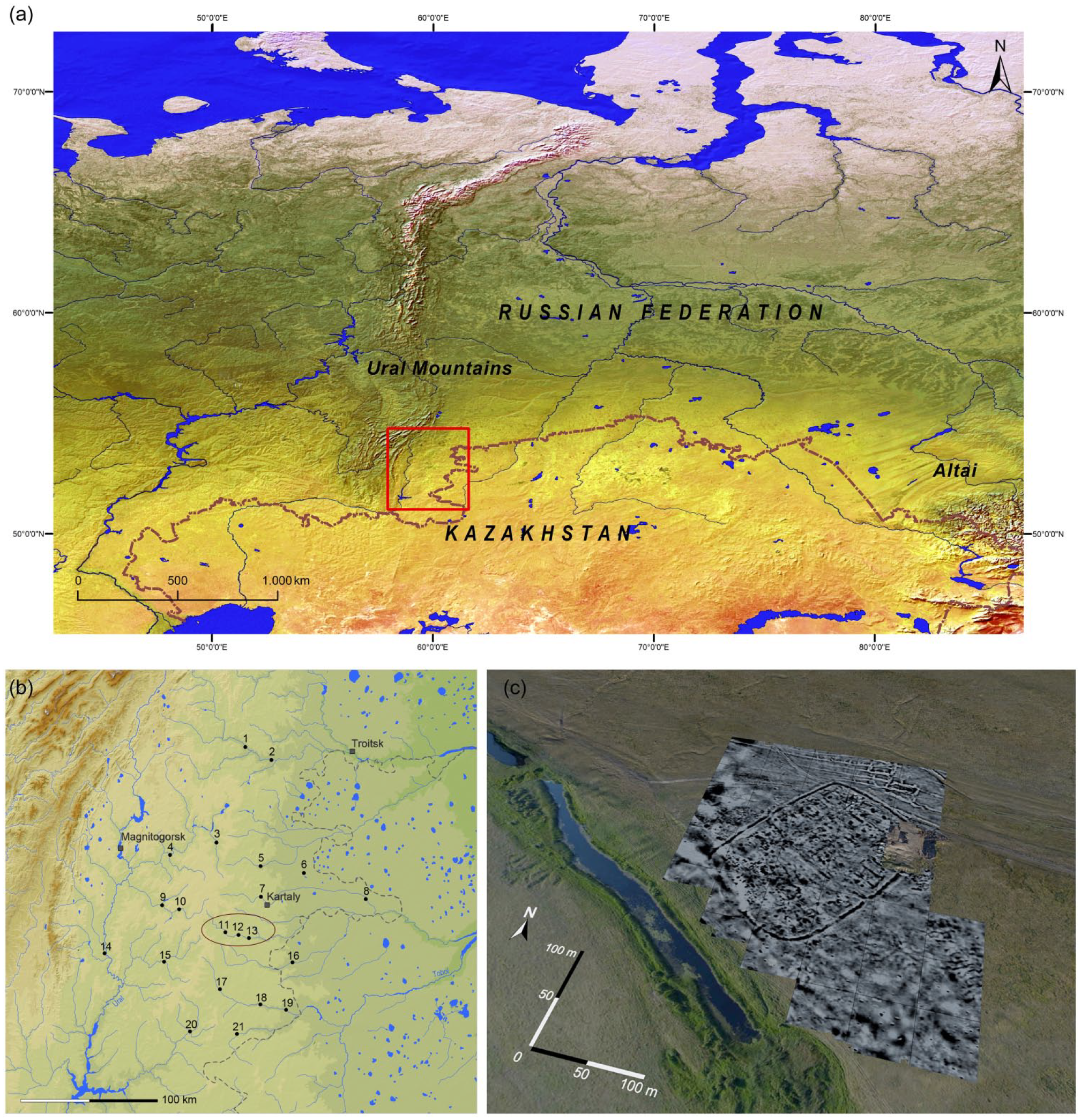
(a) Map of Eurasia. Square indicates southern Transural region (image source: http://www.naturalearthdata.com); (b) distribution map of fortified Sintashta settlements: 1 – Stepnoye; 2 – Chernorechye III; 3 – Parizh (Astafyevskoye); 4 – Bakhta; 5 – Ustye; 6 – Chekatay; 7 – Rodniki; 8 – Isiney; 9 – Kuysak; 10 – Sarym-Sakly; 11 – Konoplyanka; 12 – Zhurumbay; 13 – Kamennyi Ambar (Olgino); 14 – Kizilskoye; 15 – Arkaim; 16 – Kamysty; 17 – Sintashta; 18 – Sintashta II (Levoberezhnoe); 19 – Andreevskoye; 20 – Alandskoye; 21 – Bersuat. Oval shows location of the Karagaily-Ayat micro-region (mapped by Knoll, 2014); and (c) combined illustration of an aerial photo and geomagnetic results of the Kamennyi Ambar settlement (Krause and Koryakova, 2013).
Within the scope of the Russian–German joint research project ‘Environment, Culture and Society of the Southern Urals in the Bronze Age: A Multidisciplinary Investigation in the Karagaily-Ayat Microregion, Russia’, multidisciplinary investigations have been carried out in the study area since 2008 (for an overview, see Krause and Korjakova, 2014; Krause and Koryakova, 2013; Krause et al., 2010). They focus not only on the reconstruction of settlement structures but also on the environmental conditions and dynamics.
The aim of this paper is to thoroughly examine the interactions between climatic change, human activities and economies in the Transurals by combining palynological, sedimentological and plant macro-remains analyses together with radiocarbon dating. Cultural layers from archaeological excavations formed the basis to explore plant use among the inhabitants. Natural archives were used for a high-resolution palaeoenvironmental reconstruction, after pollen data had also undergone principal component analyses (PCAs) and stratigraphically constrained cluster analyses (CONISS). Vegetation mapping with the help of multispectral satellite data in combination with pollen assemblages of surface samples was used to reconstruct past vegetation distribution, estimate steppe productivity and create a model for livestock management during the Bronze Age.
Study area
The area of investigation extends from 50° to 54°N and 59° to 62°E on the Transural peneplain, located east of the southern Ural Mountains and gently dipping towards the western Siberian lowlands, about 200 km to the east (Figure 1a and b). The undulating plain reaches altitudes between 200 and 300 m a.s.l., and the dominant rock outcrops are of Mesozoic–Tertiary origin (Chernyanskiy, 1999). The regional basement rocks comprise gneisses, granites, schists and serpentinites (Görz et al., 2004). Being part of the Ural–Tobol watershed, the peneplain is dissected by broad valleys incised under periglacial conditions during the Pleistocene (Kulikov, 2005). A continental climate prevails, with a mean annual temperature of 3.7°C, ranging between −18°C in January and +20.6°C in July, and a mean annual precipitation of 300–400 mm. Chernozems are the dominant soil type, but as a result of secondary salinization, solonetz also occur (Chernyanskiy, 1999; Plekhanova et al., 2007).
The study area lies in the steppe zone and its natural vegetation is a herbaceous feather-grass and fescue/feather-grass steppe with small groves of birch (‘kolki’) and pine (‘bory’). These are restricted to places with better water supply and presently cover about 10% of the surroundings of the Karagaily-Ayat valley. The unforested areas are subject to extensive pasturing of cattle and horses, with feather-grass steppe only persisting in places with minor grazing pressure. During the ‘virgin lands campaign’ between the 1950s and 1970s, the area was transformed into farmland, which was ploughed and subjected to fertilizer and pesticide application. Around 50–55% of those fields are still used for cereal production nowadays.
The micro-region of the Karagaily-Ayat River valley
The valley of the Karagaily-Ayat is several kilometres wide, but in the area around Kamennyi Ambar, the river cuts only 20–40 m into the Transural peneplain. The floodplain of the Karagaily-Ayat is subdivided into a lower and a higher part and bordered by one to two Pleistocene terraces. Together with the surrounding periglacial cover beds, these deposits contain a mixture of weathered saprolite, alluvial and colluvial loams and, to a lesser extent, some in situ loess. The dominant soils in the micro-region are luvic (decalcified) Chernozems, partly with protovertic, gypsic or sodic properties due to the nature of the sediments or the recent salinization of top soils (Chernyanskiy, 1999; Plekhanova et al., 2007; Thiemeyer and Peters, 2016). In the floodplain of the Karagaily-Ayat, species-rich meadow steppes with Geranium, Limonium, Thalictrum and other herbs have formed. These productive meadows serve as favourable grazing sites, especially in dry years (Stobbe, 2013). The Karagaily-Ayat River is perennial; its valley contains numerous abandoned river channels. Some of these depressions are open and filled with water while others have silted up completely; nevertheless, they all react sensitively to variations in climate. The small lakes are also used for watering animals, and their vegetation is especially affected by grazing (Wittig et al., 2013).
Archaeological context
Owing to aerial archaeology, survey and excavations, 21 fortified settlements are known in the Transural region (Batanina et al., 2014; Fornasier, 2014). Along a 20-km segment of the Karagaily-Ayat River, the Konoplyanka, Zhurumbay and Kamennyi Ambar sites are located relatively close to each other in contrast to the average distance of about 23 km between Sintashta sites (Knoll, 2014). This micro-region has been under archaeological focus since 2005 (Hanks and Doonan, 2009; Krause and Korjakova, 2014; Krause and Koryakova, 2013; Krause et al., 2010). Geophysical investigations in several settlements and archaeological excavations at Konoplyanka and Kamennyi Ambar assisted in the reconstruction of outlines and internal structures (Fornasier, 2014; Knoll, 2014; Koryakova et al., 2013).
At Konoplyanka, 21 buildings were counted and at least 41 were identified at Zhurumbay. The settlement area at Kamennyi Ambar (Figure 1c) with approximately 41–42 buildings in its initial phase was later reduced to 25–26 house units. Household sizes were estimated to be 8–10 or 6–10 persons, respectively (Knoll, 2014; Krause, 2013). The above-ground and slightly deepened buildings were made of wood and clay with some internal subdivisions and structures like ovens, small pits, and particularly remarkable well features with excellent wet preservation of organics. The stratigraphy attests successive occupations, a conclusion that is further supported by the existence of up to 15 wells within 1 house unit. Radiocarbon dates enabled the division into a Sintashta (-Petrovka) period between 2100 and 1950 cal. BC (1σ) and – after a gap – a late Bronze Age Srubnaya-Alakul period from 1890 to 1650 cal. BC (1σ) at the site (Epimakhov and Krause, 2013). The Srubnaya-Alakul buildings differ in construction and do not follow the course of the earlier fortified Sintashta structures. Kosarev (1991) assumes household sizes of five persons for the late Bronze Age period. The people of the subsequent final Bronze Age period are supposed to have been more mobile with a reduced percentage of cattle in favour of more sheep and horses in the herd and a change in burial customs (Epimakhov, 2010b; Koryakova and Epimakhov, 2007).
Kurgans (earthen burial mounds), associated with the Kamennyi Ambar settlement are situated on the opposite river bank about 1 km to the south (Epimakhov, 2005).
Materials and methods
Sampling and dating
Results presented here are mainly based on the cores from the Lake FS (220 cm), the silted Lake PW (290 cm), both in ca. 1 km distance from Kamennyi Ambar (see Stobbe et al., 2015 for map and details), and Lake Weihe (290 cm) (Krause et al., 2010; Stobbe and Kalis, 2012) which is located 1.9 km from the Zhurumbay settlement. Today, Lake FS is 40 m × 30 m in size. Adjoining the outer margin of the open water are a floating community of Stratiotetum aloides, a reed bed of Schoenoplecto-Phragmitetum, a large sedge community (Caricetum elatae) and finally a belt of floodplain meadow. Lake PW comprises a 15-m-wide, circular depression. It is nowadays completely dry, covered with Lycopus europaeus and enclosed by a belt of floodplain meadow. The study site Lake Weihe, ca. 80 m × 40 m in size, has already silted up to a great extent in the eastern part. It has an almost 100% coverage with Carex elata, whereas in the northwest a small floating community of Stratiotetum aloides exists on the open water surface, bordered by a reed bed of Schoenoplecto-Phragmitetum. The study material was retrieved with an open core drill (6-cm diameter) in overlapping segments.
In total, 24 samples of terrestrial plant material (seeds and fruits) taken from the sediment cores were radiocarbon-dated by acceleration mass spectrometry (AMS) at the laboratories of the University of Cologne (Centre for Accelerator Mass Spectrometry), Beta-Analytic (London/Miami) and the Curt-Engelholm-Zentrum, Archaeometry (Mannheim/Tübingen). The 14C-results (Table 1) were calibrated with OxCal 4.2.4 (Bronk Ramsey, 2009; Reimer et al., 2013).
Radiocarbon dates from off-site archives in the Karagaily-Ayat micro-region. OxCal v4.2.4; IntCal13 atmospheric curve (Reimer et al., 2013).
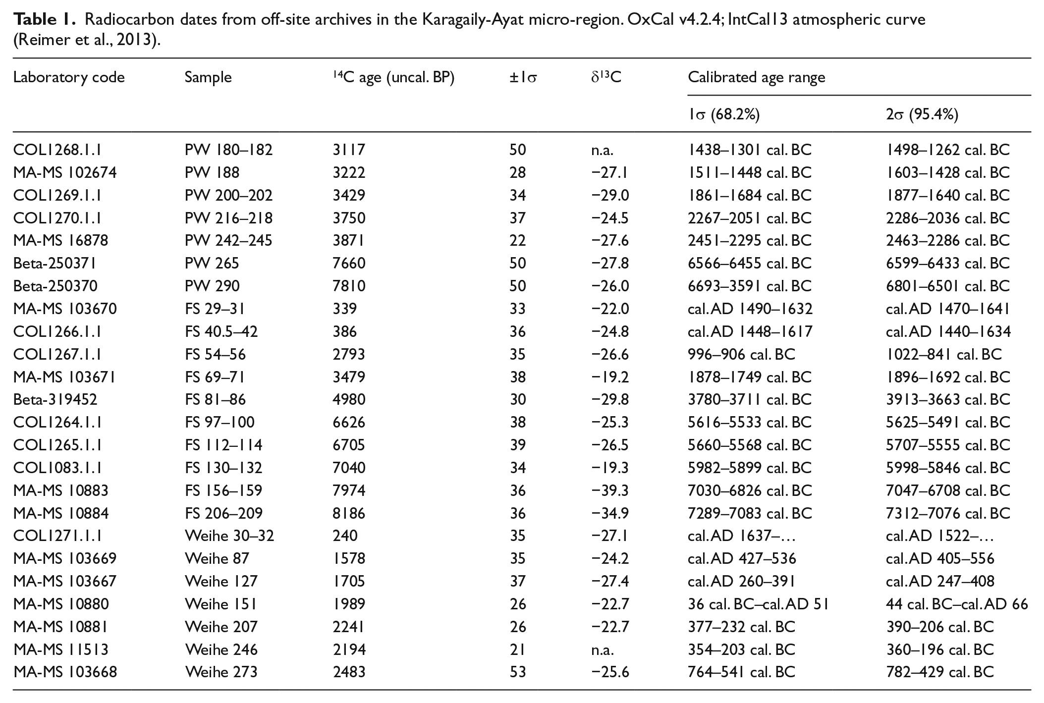
The calibrated dates were used to model age–depth relationships together with sedimentological and palynological information, allowing the interpolation of deposition rates and hiatuses (also see Stobbe et al., 2015).
Pollen analysis
Sediment samples of 0.3 cm3 from the lakes FS, PW and Weihe were taken for pollen analysis and preprocessed following a standard method (Fægri and Iversen, 1989). The pollen grains were mounted in silicone oil and identified under a light microscope (magnification ×480 and ×756 for detailed structures and surface patterns), using the departmental reference collection, which, in the course of this research, had been continuously supplemented with Russian plant specimens. Furthermore, standard reference sources and identification keys were used for taxa identification (Beug, 2004; Fægri and Iversen, 1989; Moore et al., 1991; Punt and Clarke, 1976–2003; Reille, 1992, 1998). The pollen types were divided into local (occurring in the immediate vicinity of lakes or rivers) and regional species (unrelated to wetlands). The calculation of pollen and microfossil percentages was based on the regional pollen sum between 300 and 1100 grains including trees, shrubs and herbs. Poaceae pollen were included in the basic pollen sum, but Cyperaceae were excluded. The resulting percentage pollen diagrams were created with the software packages Tilia/Tilia-Graph and TGView 1.7.16 (Grimm, 1993, 2004). Since this paper focuses on regional landscape changes, pollen assemblage zones (PAZ) were defined according to differences in the regional pollen composition. Only regional pollen diagrams are presented in this study (for local pollen diagrams, see Stobbe et al., 2015). The pollen zonation is based on visual estimation and statistical analyses performed with CONISS (Grimm, 1987). Surface samples from nine natural wet coring sites in the Karagaily-Ayat micro-region are considered.
PCA
For statistical comparisons, a variety of multivariate tests were run, of which PCAs based on species abundances provided maximum information on the characteristics of pollen assemblages. They were carried out with R software (R Core Team, 2013) and the enlargement package Vegan (Oksanen et al., 2013), followed by chord transformations after Orloci (1967) and Legendre and Gallagher (2001), because of prevalent nil values. In order to support evident clusterings in the PCA ordination plots, an unconstrained variant of CONISS (Grimm, 1987) was performed as well, also with chord distance as proximity measure.
Vegetation mapping
In order to map and quantify recent land cover patterns in the area of study, Landsat 7, Spot and ASTER scenes of various recording dates (courtesy of the U.S. Geological Survey) were processed and compared visually in Erdas Imagine 14. Apart from meadow steppes, forests (either pine or birch) and open water bodies were identified. The dominant regional steppe vegetation, together with cultivated areas such as farms or settlements, was considered to represent the Bronze Age extent of the steppe and consequently labelled as such.
Several ASTER scenes and one Landsat image recorded between June 2000 and June 2008 were selected for further analyses in Erdas Imagine and ArcGIS 9. Unsupervised as well as supervised classifications were carried out, but results were affected by the strong overlap of birch woods and meadow steppe in the near-infrared spectrum. However, manual masking of man-made structures, separation of forests and grasses by textural differences, the association of meadow steppes with floodplain sites and the comparison with high-resolution imagery in Google Earth yielded a high level of accuracy in the final output maps.
Analysis of plant macro-remains
Sediment samples for plant macro-remain analysis were collected systematically from building features and cultural layers that did not appear to be disturbed by bioturbation. The sample sizes ranged from 0.1 to 6.5 l of displacement volume, depending on feature size, excavation technique and soil structure. In total, 46 samples with a displacement volume of 179 l were selected for this paper.
The samples were wet-sieved in the field using a test sieve column with a smallest mesh size of 0.315 mm. Sorting and identification were done at ×6–40 magnification. Following an actualistic approach (Jacomet and Kreuz, 1999), the macrofossils were grouped according to their habitat requirements, taking into account the particularities of the steppe environment and modern vegetation composition (Kulikov, 2005; Wittig et al., 2013) as well as the results of the pollen analyses (Stobbe, 2013; Stobbe et al., 2015). For identification of seeds, fruits and other plant parts, the departmental reference collection, which was enlarged throughout this research by modern comparative material of steppe plants in the study area (Wittig et al., 2013), identification guides (e.g. Cappers et al., 2006) and archaeobotanical literature, was used. The plant taxa were grouped into vegetation units as follows – steppe woodland, steppe, ruderal steppe, meadow steppe and riparian zone (Rühl et al., 2015).
Results and interpretation
Sedimentation history
Figure 2 gives an overview of the lithological and chronostratigraphical characteristics of the three featured profiles, while details on related radiocarbon dates can be taken from Table 1 (for more data concerning sedimentological and geochemical analyses, see Stobbe et al., 2015). All profiles show one to several hiatuses. They appear as (a) a reduction in organic matter and an increase in riparian vegetation, followed by the disappearance of aquatic plants, (b) a reduction in organic matter without obvious changes in the local or regional pollen spectra, showing either an abrupt climatic change leading to a quick desiccation of the water body or the subsequent erosion of sediments in the course of aridification, or (c) no sedimentological changes – that is, the hiatus is only identifiable by the help of radiocarbon dating and minor changes in the local vegetation. The presence of sediments may thus be indicative of a humid environment, but it is, however, not possible to deduct the existence of arid conditions from their absence because internally or externally triggered erosion always has to be taken into account (Stobbe et al., 2015).

Sediment profiles from coring sites Lake FS, Lake PW and Lake Weihe.
The sediments found at Lake FS comprise fluvio-lacustrine silts and loams with varying contents of organic matter and some embedded sandy layers marking phases of increased fluvial activity. The accumulation of sediments began around 7200 cal. BC, but a first hiatus is noticeable as early as 4400 cal. BC at 96 cm. It is characterized by a reduction of organic matter but no obvious changes in the pollen spectra, probably as a result of the complete desiccation of the water body. A second hiatus between 81 and 72 cm is not reflected by any structural or geochemical evidence within the relatively uniform loams. By the help of radiocarbon dating and a detected change in the local vegetation composition, however, it has been located at 74 cm. On top of a third hiatus at 51 cm, loams of similar texture but with distinctly higher organic values occur. Lake PW encompasses highly organic lacustrine silts including intercalated peats as well as weakly organic fluvial sands and clays. At the bottom of the core, loams date back to 6800 cal. BC. They are topped by a coarse sandy channel-bed deposit between 252 and 248 cm which is accompanied by a major hiatus, spanning around 4000 years. The chronology with four radiocarbon dates between 248 and 185 cm reveals a relatively undisturbed, uninterrupted sedimentation of partly organogenic loams with some intercalated sands throughout this period. A thick colluvium in the upper 150 cm marks the end of fluvio-lacustrine dynamics at this site.
The sediments at Lake Weihe are composed of layers of sands, silts and highly organic silts and some peats in the upper half of the profile. The filling started at 600 cal. BC and continued until cal. AD 600 (Kalis and Stobbe, 2012; Krause et al., 2010). Above a hiatus of around 1000 years at 70 cm, minerogenic material has been deposited during the last 400 years.
Pollen analysis
Lake FS
In the pollen diagram, five PAZ were recognized (FS 1 to FS 5) (Figure 3).
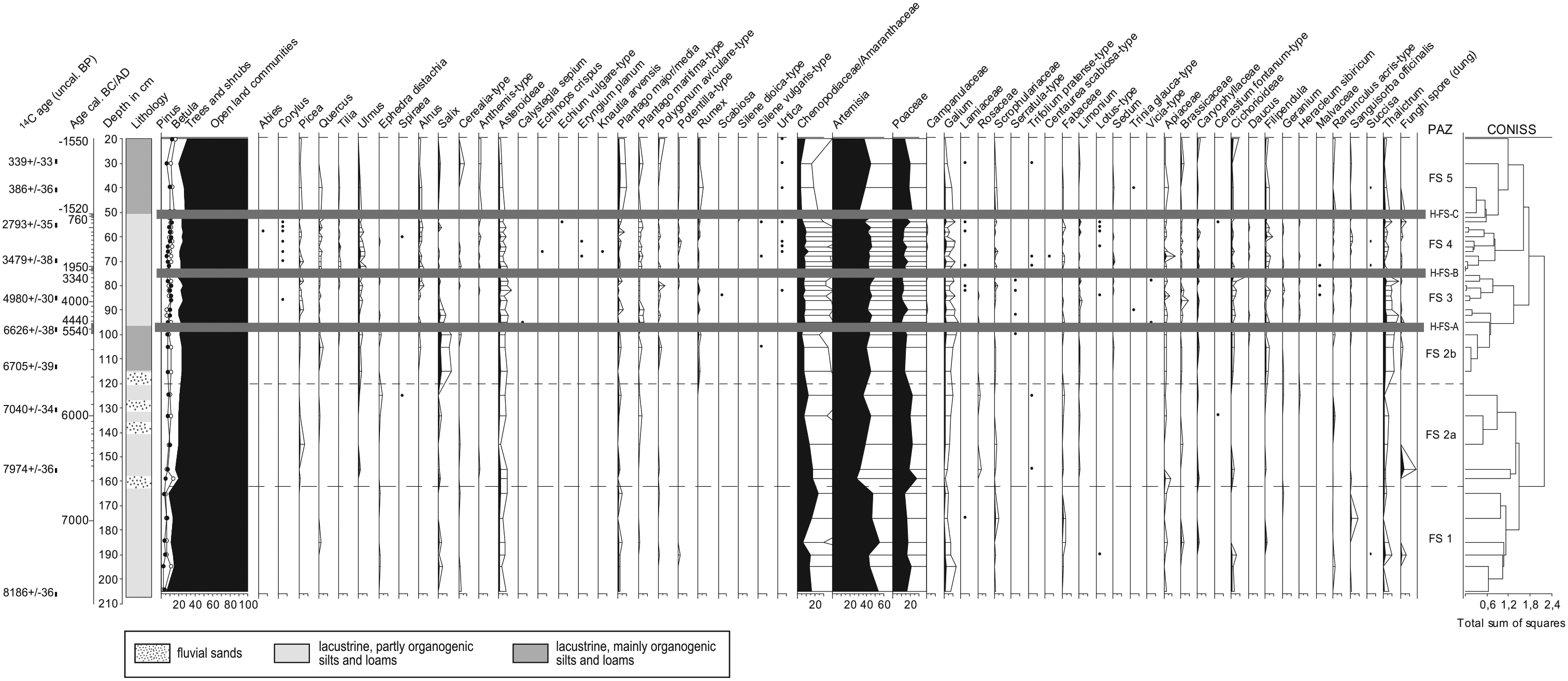
Regional pollen diagram of Lake FS. Percentages based on total terrestrial pollen counts (TTP), plotted on time and depth scale; hiatuses are marked by grey bars.
PAZ FS 1: 7180–6910 cal. BC (205–162 cm)
The dominant taxa are Artemisia and Poaceae, but Chenopodiaceae also play an important role. The AP (Arboreal Pollen) values reach around 10%. The bordering floodplain is covered by a meadow with Filipendula, Succisa pratensis, Geranium and Sanguisorba officinalis. Very few trees (namely, Betula and Pinus) grow in the surroundings. Only once spores of dung-colonizing fungi are documented. The Cerealia pollen type appears.
PAZ FS 2: 6910–5540 cal. BC (162–96 cm)
Subzone FS 2a: 6910–5740 cal. BC (162–120 cm)
Betula and Pinus pollen increase, pollen grains of Picea are found regularly and Tilia and Quercus appear for the first time. The ratio between Chenopodiaceae and Poaceae changes: Poaceae reach more than 20%, while Chenopodiaceae drop to less than 10%. Artemisia still remains dominant with more than 40%. A feather-grass steppe is established, with other herbaceous plants, such as Galium, Apiaceae and Brassicaceae, among others. Just once spores of dung-colonizing fungi are documented. The Cerealia pollen type is present.
Subzone FS 2b: 5740–5540 cal. BC (120–96 cm)
Salix values increase significantly and broad-leaved deciduous trees like Ulmus, Quercus and Alnus increase as well. Ephedra is constantly present. In the feather-grass steppe, Chenopodiaceae and Poaceae decrease. Many herbs that are known as indicators of disturbances such as Polygonum aviculare, Polygonum persicaria and Rumex appear. A few spores of dung-colonizing fungi are documented. The Cerealia pollen type is still present. A hiatus separates this zone from PAZ FS 3.
PAZ FS 3: 4390–3560 cal. BC (96–74 cm)
Values for AP remain stable. Picea and Ulmus are continuously present, whereas Quercus and Alnus appear occasionally, and Corylus is found once. Artemisia percentages remain unchanged, while Chenopodiaceae increase slightly. A larger number of herbs like Trinia glauca, Galium, Serratula-type, Sanguisorba officinalis, Heracleum sibirica, Lotus or Scrophulariaceae points towards a steppe vegetation that was rich in species. Spores of dung-colonizing fungi are rare. A hiatus separates this zone from PAZ FS 4.
PAZ FS 4: 2280–760 cal. BC (74–51 cm)
Among the regional vegetation, AP values increase to 20%, with a slight increase of Pinus and a significant increase of broad-leaved deciduous trees. Ephedra is present. Values of Artemisia are stable; Chenopodiaceae decrease clearly at the top of the zone, whereas Poaceae rise. Herbaceous species diversity increases once more and indicators of disturbances (e.g. Polygonum aviculare, Rumex and Echinops) are present, as well as the Cerealia pollen type. Spores of dung-colonizing fungi are regularly documented. A hiatus separates this zone from PAZ FS 5.
PAZ FS 5: cal. AD 1520–1950 (51–30 cm)
AP percentages rise slightly because of the increase in Betula. Picea, Alnus and Ulmus are constantly present. Salix and Corylus are abundant. Tilia and Quercus are rare, and Ephedra vanishes. Among the NAP (Non-Arboreal Pollen), values of Anthemis-type, Rumex and Plantago major/media increase. Poaceae increase up to 20%. There is a decline in Chenopodiaceae as well as in the diversity of species. Only once spores of dung-colonizing fungi are documented. The Cerealia pollen type is present.
Lake PW
Only the Bronze Age part of the pollen diagram is presented and elaborated here. It comprises four PAZ, out of which PW 3a corresponds to the Sintashta-Petrovka occupation and PW 3b to the Srubnaya-Alakul occupation phase. (PW 1 to PW 4) (Figure 4).

Regional pollen diagram of Lake PW. Percentages based on total terrestrial pollen counts (TTP), plotted on time and depth scale.
PAZ PW 1: 2390–2290 cal. BC (248–235 cm)
AP values reach about 15%. Betula is dominant, followed by Pinus and Picea. Broad-leaved deciduous trees occur in small amounts. The dominant vegetation is steppe with Poaceae and Artemisia; Galium and Apiaceae are abundant. On saline and disturbed sites, Chenopodiaceae and Plantago maritima are common. Ephedra occurs occasionally. Spores of dung-colonizing fungi are regularly found. The Cerealia pollen type is present. In the bordering floodplain area, a meadow with Thalictrum and Filipendula prevails.
PAZ PW 2: 2290–2060 cal. BC (235–213 cm)
Among the regional vegetation, Pinus is dominant with 20% while Betula has slightly decreased. Pollen grains of Picea and broad-leaved deciduous trees are regularly present. Artemisia decreases but still remains dominant with ca. 40%. Chenopodiaceae as well as Plantago maritima, Polygonum aviculare, Limonium and spores of dung-colonizing fungi are regularly documented. The Cerealia pollen type appears sporadically. Peaks of Plantago maritima and Galium at the top of the zone are attributed to local effects.
PAZ PW 3: 2060–1570 cal. BC (213–191 cm)
Subzone PW 3a: 2060–1810 cal. BC (213–203 cm)
Betula and Pinus rise distinctly and broad-leaved deciduous trees like Ulmus, Quercus, Tilia and Alnus appear regularly. Chenopodiaceae show a distinct peak of nearly 20% at the bottom of the zone and Artemisia decreases. At the top of the zone, Chenopodiaceae decrease and Poaceae increase. Dung-colonizing fungi are reduced. Geranium and Sanguisorba officinalis grow in the floodplain meadow.
Subzone PW 3b: 1810–1570 cal. BC (203–191 cm)
The values of trees and Artemisia remain unchanged. Chenopodiaceae values are low (<10%) and Poaceae decrease. Around 1700 cal. BC, dung-colonizing fungi are no longer proven. The composition of herbs indicates the presence of species-rich steppe vegetation.
PAZ PW 4: 1570–880 cal. BC (191–155 cm)
Betula values and numbers of herbaceous species are reduced. Values of Artemisia show a short-term rise but eventually give way to significantly increasing values of Chenopodiaceae.
Lake Weihe
In the pollen diagram, six PAZ were recognized (Weih 1 to Weih 6) (Figure 5).

Regional pollen diagram of Lake Weihe. Percentages based on total terrestrial pollen counts (TTP), plotted on time and depth scale; hiatuses are marked by grey bars.
PAZ Weih 1: 620–400 cal. BC (288–253 cm)
The pollen spectrum is dominated by NAP. They reach about 80% of the regional pollen sum and represent steppe vegetation, with Artemisia, Poaceae, Chenopodiaceae and other herbs. Plantago major/media and Polygonum aviculare as typical representatives of ruderal sites are regularly present, just like the Cerealia pollen-type.
PAZ Weih 2: 400–210 cal. BC (253–203 cm)
Subzone Weih 2a: 400–310 cal. BC (253–233 cm)
The AP/NAP-ratio remains nearly the same, but the proportions within the steppe pollen types change. Artemisia decreases to its lowest level in favour of Poaceae and Chenopodiaceae. The composition of herbs indicates the presence of species-rich steppe vegetation. The Cerealia pollen type is proven.
Subzone Weih 2b: 310–210 cal. BC (233–203 cm)
AP reach their highest value, with up to 38%. The pollen curves of the steppe indicators correspond to the values of zone 1. The ruderal steppe indicator Plantago major/media increases. Polygonum aviculare and the Cerealia pollen type are found in similar amounts.
PAZ Weih 3: 210 cal. BC–cal. AD 90 (203–145.5 cm)
Subzone Weih 3a: 210–40 cal. BC (203–163 cm)
AP values are rather stable but Ulmus decreases significantly. Plantago maritima and Chenopodiaceae rise, possibly pointing at saline conditions in the surroundings.
Subzone Weih 3b: 40 cal. BC–cal. AD 90 (163–145.5 cm)
AP values remain largely unchanged, but the percentage of broad-leaved deciduous trees, apart from Ulmus, drops sharply. The number of herbs declines as well. Artemisia reaches values over 50%, while Poaceae are at a minimum.
PAZ Weih 4: cal. AD 90–440 (145.5–98 cm)
AP percentages are variable, especially Pinus values decline gradually. Artemisia values rise to over 50%. The broad-leaved deciduous trees Corylus, Alnus Tilia, Quercus and Ulmus are present. The occurrence of Plantago major/media, Polygonum aviculare and Rumex points to ruderal conditions within the steppe environment. The Cerealia pollen type is regularly proven.
PAZ Weih 5: cal. AD 440–630 (98–50 cm)
AP values (especially Pinus, Picea) increase shortly up to 50%; Quercus and Alnus are abundant. Artemisia values drop sharply under 20%. The pollen grains of Plantago major/media, Polygonum aviculare and Rumex represent ruderal conditions. The values of Poaceae are unchanged but the Chenopodiaceae rise up to 20%; the Cerealia pollen type is present. A hiatus separates this zone from PAZ Weih 6.
PAZ Weih 6: cal. AD 1610–1920 (45–10 cm)
The steppe vegetation has undergone significant changes. Broad-leaved deciduous trees on river banks have largely disappeared and Poaceae have decreased as well. In return, Brassicaceae are on the rise – probably as a mere local phenomenon. Plantago major/media and Rumex underline the existence of ruderal sites.
Surface samples
Samples 1–7 are comparatively homogeneous concerning their composition of pollen types. AP reach between 21% and 42% and are dominated by Pinus and Betula (Figure 6). Values of other broad-leaved deciduous trees vary between 0.5% and 3%. Artemisia amounts to 20–37%, Poaceae values range between 10% and 24%. Chenopodiaceae reach 6–14%. Plantago major/media and other herbs attest the presence of ruderal sites. All samples contain Cerealia as well as Polygonum aviculare with values up to 2.7%.
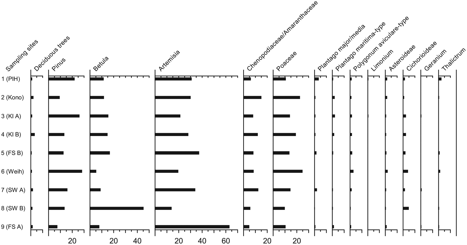
Relative frequencies of selected pollen types from surface samples. Taxa correspond with those in Figure 7 (PCA), except for Ephedra which was absent from depicted samples.
Samples 8 and 9, however, show some peculiarities. AP reach almost 60%, with a dominance of Betula at 45% in sample 8. In contrast, Artemisia values of 13.7% are considerably below those of other surface samples. In sample 9, the ratio is inverse with Artemisia at 62% and tree pollen at a mere 15%. Cerealia pollen are constantly present, together with Polygonum aviculare. Both samples are strongly influenced by local conditions.
Statistics
For palaeoecological interpretations, we concentrated on selected regional taxa reacting sensitively to either changes in humidity or anthropogenic pressure, namely, broad-leaved deciduous trees (sums of Acer, Alnus, Carpinus, Corylus, Fraxinus, Populus, Quercus, Tilia and Ulmus), Betula, Pinus, and herbs including Artemisia, Asteroideae, Chenopodiaceae, Cichorioideae, Ephedra, Geranium, Limonium, Plantago maritima, Plantago major/media, Polygonum aviculare and Thalictrum.
The PCA (Figure 7) encompasses profiles FS, PW and Weihe as well as the surface samples. The first two axes reflect approximately 64% of the total variation, with PC 1 revealing strong negative correlations of Artemisia/Ephedra on one side and Pinus/broad-leaved deciduous trees on the other, reaching scores around +0.45 and − 0.42, respectively.

Principal component score and loading plots, depicting (a) pollen assemblage zones (PAZ) and (b) species vectors (Arte: Artemisia; Aster: Asteraceae; Bet: Betula; Cich: Cichorioideae; Chen: Chenopodiaceae; DT: deciduous trees; Ephe: Ephedra; Gera: Geranium; Limon: Limonium; Pin: Pinus; PlanMajo: Plantago major/media; PlanMari: Plantago maritima; Poa: Poaceae; PolAvi: Polygonum aviculare; Thali: Thalictrum).
The distribution of the pollen zones shows clear clusters of FS 1, FS 2a, FS 2b, FS 3, FS 4 PW 1, PW 2 and Weih 3 in the direction of the Artemisia/Ephedra vector, on one hand, and PW 3a, PW 3b, Weih 1, Weih 2, Weih 4 Weih 5, Weih 6, FS 5 and surface samples in the direction of Pinus and broad-leaved deciduous trees, on the other. Artemisia and Ephedra are sensitive to grazing pressure (and therefore indicate minimum disturbance), while broad-leaved deciduous and pine trees serve as evidence for a certain degree of humidity. Other obvious antagonists of Artemisia with distinctly higher loadings on PC 2 include Cichorioideae, Polygonum aviculare, Plantago major/media and Poaceae, which all reflect a certain influence of grazing. These results are an indication that effects of aridity and animal husbandry are clearly separable in the pollen spectra. The congruence of samples between approximately 2400 and 1600 cal. BC, 600 cal. BC and cal. AD 600, and during the last 400 years with surface spectra underlines the similarity to the present-day vegetation units and the underlying environmental factors (climate and human impact) (Stobbe et al., 2015).
Vegetation mapping
The comparison of surface samples with Iron and Bronze Age pollen assemblages shows that the vegetation composition has remained fairly stable (Figure 7; Stobbe et al., 2015). As a consequence, the assessment and quantification of recent land cover patterns can be used to gain information on the Bronze Age environment.
A toal of 13 mapping areas were selected, 8 of which were centred around the Sintashta sites of Ustye, Rodniki, Sarym-Sakly, Zhurumbay, Konoplyanka, Kamennyi Ambar, Arkaim and Sintashta itself, listed from north to south (Figures 1b and 8a, Table 2). Three reference areas are located along a stream south of the Karagaily-Ayat micro-region with a similar environment but lacking fortified settlements. The mapping areas are predominantly circular with a radius of 4 km. This corresponds to half the distance between the adjacent settlements, Zhurumbay and Kamennyi Ambar, that is, the minimum size of independently managed economic zones in the immediate surroundings. On this basis, percentages of water, forest, and meadow steppe were determined, with remaining areas being actual or potential steppe. In addition to Transural sites, the surroundings of two settlements Isiney und Kamysty, were also mapped to facilitate comparisons with the transition zone to the Siberian lowlands in the east.

(a) Overview of selected fortified settlements for vegetation mapping and (b) Karagaily-Ayat micro-region with the autonomous economic activity zones of 4 km radius around Konoplyanka, Zhurumbay and Kamennyi Ambar (subset of Figure 6a; all imagery in false colours).
Area sizes of mapped vegetation units of selected fortified settlements (in bold: settlements from the Karagaily-Ayat micro-region).

The results in Table 2 confirm an expectable decrease of forest at lower latitudes (with the exception of Konoplyanka, where forested hillsides are found in the immediate vicinity of the stream). Lowland sites in the east are completely unforested. Percentages of open water bodies and floodplain meadows neither follow a north–south nor west–east gradient, but there is a tendency towards larger areas of meadow steppe in the south, including the test plots without settlements. High values of meadow steppe in the eastern area around Isiney, however, are because of the specific situation as the area is characterized by numerous closed depressions with meadow vegetation. Land cover values do not differ significantly except for forests (as evident in Table 2). Meadow steppe percentages, however, show the strongest overall variance with similarly high values between Konoplyanka and Kamennyi Ambar and the valley without fortified settlements, respectively.
Analysis of plant macro-remains
The charred and mineralized plant macro-remains (n = 2521) represent 49 different plants (genus and species level) of 24 plant families (Rühl et al., 2015). The quality of preservation was heterogeneous, with samples showing intact fragile Poa caryopses, on one hand, and heavily eroded Fabaceae, on the other. Average seed density comprises less than 6 items per litre. Furthermore, animal bones, fish remains, insects, molluscs, artefacts and ceramics were found (Stobbe et al., 2013).
Chenopodiaceae (31%) and Fabaceae (26%) were the most common plant families among seeds and fruits (mainly represented by Chenopodium album, the Trifolium/Melilotus/Medicago-group and Vicia), followed by a group of non-distinguishable Polygonaceae/Cyperaceae (11%) (Figure 9a). Other frequent taxa like Betula and Stipa are represented by other residue types comprising leaf scars and awn fragments. Interestingly, Poaceae amount to only 8% of plant families even if caryopses (Poa type, Stipa sp., and some other categories not identified to species level) and other plant parts like Stipa awns are included (Rühl et al., 2015).
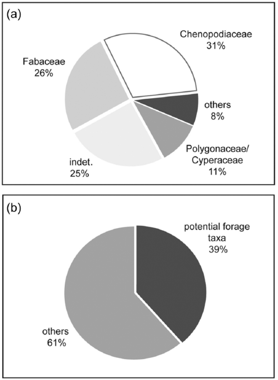
Results of plant macro-remains analysis: (a) plant family distribution among charred fruits and seeds (families with >5 finds included; n = 1050) and (b) proportion of potential forage plants from total taxa of charred plant macro-remains (n = 70).
All plant macro-remains from Kamennyi Ambar and Konoplyanka belong to wild herbaceous plants and trees from the steppe area. Residues of cultivated plants were not found. Although only parts of the settlement areas have been excavated so far, we consider the samples to be representative because they were collected from all feature units: the fortification system, several house units and spaces between them as well as from domestic structures. The ongoing study of the well features with waterlogged uncharred material increases the existing taxa list considerably by currently 33 plant categories, but again no cultivated plants are present.
Discussion
Ecology
Climate is often seen as one of the major driving forces for human migration and other socio-economic changes in the Eurasian steppe ecoregion. Many scholars also believe that periodic climate changes have caused several shifts between nomadism and sedentarism in the last millennia (Chernykh, 2008). The construction of fortified settlements during the Sintashta period also seems to be related to climatic conditions and can thus be understood as a subsistence strategy against the background of a specific ecological and socio-political framework.
Nowadays, the natural environment of the area is very uniform. Hence, the specific constellation of ecological conditions is regarded as a crucial factor in the appearance and distribution of Sintashta settlements. To what extent these conditions, particularly climate and vegetation composition during the Bronze Age, resembled the present setting is still in dispute, and according to different authors, both humid and arid conditions are postulated. While pedological analyses seem to suggest a more humid climate, accompanied by a southward shift of vegetation belts in general and the forest steppe in particular (Gayduchenko, 2002; Lavrushin and Spiridonova, 1999), other studies emphasize the existence of arid conditions and a reduction of forest cover (Kremenetski, 2003). Our palynological and sedimentological results, supported by statistical analyses, show that the pollen zones from the Sintashta period and the time between 600 BC and AD 600, together with the last 400 years and surface samples, probably reflect similar vegetation patterns. Artemisia, Chenopodiaceae and Poaceae dominate all the pollen spectra and tree pollen reach maximum levels of 30–35%. This represents a typical pollen composition of the dry Euro-Siberian steppe (Liu et al., 2006; Pelánková et al., 2008). The palynological data in this period point to vegetation types which resemble the recently developed species-rich feather-grass steppe with forest islands on edaphically favourable sites and meadows along recent and ancient river channels. It is unlikely that Pinus–Betula forests ever exceeded their present extent of about 10% in the study area, as revealed by comparisons with surface samples. The similar vegetation patterns may result from similar climatic conditions, as is also assumed for the southeastern steppe (Aubekerov et al., 2003; Rhodes et al., 1996). With respect to the micro-region along the Karagaily-Ayat River, a relatively humid climate predominated between approximately 2400 and 1600 cal. BC, 600 cal. BC and cal. AD 600, and during the last 400 years. We therefore have to assume that new settlement forms and economic systems in the Bronze Age related to sedentism were not developed in response to aridity, but rather as a consequence of favourable environmental conditions, along with a high biomass production within the steppe ecosystem (Stobbe, 2013; Stobbe et al., 2015).
Economy
Despite the occurrence of periodic droughts, farming was theoretically possible in the Sintashta environment (Stobbe et al., 2015). However, the results of the macrobotanical analyses at Kamennyi Ambar and Konoplyanka (Rühl et al., 2015) did not reveal evidence of agriculture for the Sintashta period. In our pollen samples, the Cerealia pollen type was identified. However, the same pollen type was accounted for in investigated surface samples from the Karagaily-Ayat floodplain and originates from the wild barley Hordeum brevisubulatum ssp. nevskianum (Wittig et al., 2013). Therefore, an unambiguous assignment of prehistoric pollen grains of the Hordeum-type to cultivated cereals is impossible in the area of investigation (Stobbe, 2013; Stobbe et al., 2015). Reports of crop cultivation, when based on pollen data from the steppe region alone, should be treated with care unless they are confirmed by complementary data sets, preferably the occurrence of macro-remains. Carbon and nitrogen stable isotope analyses from Sintashta-Petrovka necropoles in the southern Urals and northwestern Kazakhstan did not reveal the importance of cereals in the human diet either but rather attested the consumption of meat and dairy products (Ventresca Miller et al., 2014). Anthony et al. (2005) examined the Krasnosamarskoe settlement in the Samara valley west of the Urals and could not find evidence for agriculture among the late Bronze Age Srubnaya culture either. As ethnographic examples (e.g. Fernandez-Gimenez, 2000; Huai and Pei, 2000), archaeobotanical studies (Anthony and Brown, 2007; Rühl et al., 2015; Shishlina, 2001; Spengler, 2015) and isotopic studies (Ventresca Miller et al., 2014) show, pastoralists commonly supplement their diet on milk and meat with gathered wild plants, fish and occasionally hunted wild game.
Livestock management
The fortified and structured settlements of the Sintashta culture in the Bronze Age, without simultaneous practice of agriculture, represent a completely new settlement model and way of life in the steppe. It requires a ‘variation of strategies, such as different settlement or camp configurations that enables pastoralists to maintain social cohesiveness and adaptive success within the geographic and temporal fluctuations of their experienced landscape’ (Frachetti, 2008: 2). One such strategy might be the modification of the zoological spectrum of domesticated animals towards the dominance of cattle, as can be observed in the Bronze Age. While assuming the existence of a sedentary grazing system, the radius of pastures remains unclear. One possibility could be that herders drove their animals onto expansive summer pastures in the steppe and changed to pastures around the settlement (and river) in winter. On the other hand, herds may have been less mobile and were possibly kept in the immediate surroundings of the settlements during all seasons, which would also have facilitated the milking of cows. Besides valuable pastures, the limiting factor in selecting rangelands is the distance to water which should not exceed 8 km for cattle or 4 km for sheep (Asanov et al., 1994; Dahl and Hjort, 1976). Since the climate was probably humid in the Sintashta settlement area during the Bronze Age, we assume that rivers were perennial and many watering holes existed throughout the year providing sufficient water. Furthermore, the numerous wells in the settlements guaranteed access to water in winter (cf. Boroffka and Mantu-Lazarovici, 2011).
Our land cover mapping revealed that the vegetation composition of the adjacent settlements (Konoplyanka, Zhurumbay and Kamennyi Ambar) in the Karagaily-Ayat valley shows rather similarities than differences compared with other areas. Assuming that the settlements were inhabited contemporaneously, they were each equipped with autonomous economic activity zones of a 4- to 5-km radius (see Figure 8b). The sustainable management of ecological resources must have been possible within the available space. We applied two different models in order to investigate whether such an area – specifically the area around Kamennyi Ambar (as the largest of these settlements) – was suited for herd sizes big enough to sustain the local population during the Sintashta settlement phase.
Model A calculates the biomass production and grazing capacity of the given rangeland and determines the number of animals which can be sustainably managed within the 4-km radius throughout the year. The model is based on the recent vegetation distribution and respective area sizes derived from the vegetation mapping (Tables 2 and 3). Model B uses the population figures based on the number of houses in the settlements and the assumed number of livestock per capita to derive potential herd sizes. In the end, results of both models are compared and discussed.

Model A
Biomass production shows a high interannual fluctuation because of precipitation variability and timing. That is why we chose the average productivity of the vegetation units per ha (4.5 t of fresh forage in the steppe and 8 t fresh forage in the meadow steppe) as the basis for calculating the grazing potential within the assumed autonomous economic activity zones around the settlements (Table 3(a) and (b)).
In order to estimate the carrying capacity per zone, the different vegetation units and species compositions had to be considered and weighted. First, the required intake of fresh forage per day was assessed for each species. Values vary according to reduced digestibility in winter (Robinson, 2000), so we chose the average values given in Table 3(c). As the available grazing areas comprise steppe and meadow steppe pastures, they were divided in line with varying dietary preferences and habitat requirements. The productive and species-rich meadow steppe was considered as grazing ground for cattle only, while the steppe area was divided among cattle, sheep and horses in compliance with the herd composition of 50% cows, 40% sheep and 6% horses according to archaeozoological results from Kamennyi Ambar. The remaining percentages represent dogs and some pigs (Rassadnikov et al., 2013).
Our calculations show that the autonomous economic zone around Kamennyi Ambar could feed up to 816 cattle, 10,274 sheep and 343 horses, assuming year-round grazing. This is equivalent to a stocking rate of 0.47 livestock units (LSU)/ha (1 LSU = 1 cow = 1 horse = 10 sheep). This result falls within the range given by Schultz (2008), who estimates the stocking rate of the Asian grass steppe between 0.16 and 0.5 LSU/ha.
Model B
Kosarev (1991) determines household sizes of 5 persons for the late Bronze Age, while for the Sintashta settlements, numbers range from 8 to 10 or 6 to 10, respectively (Knoll, 2014; Krause, 2013). Due to this divergence, we based our model on a minimum and a maximum estimate of the population at Kamennyi Ambar, calculated from the total number of houses (41) multiplied with a household size of 5 and, second, a household size of 10.
For the late Bronze Age, a per capita number of 2.4 animals is estimated (Kosarev, 1991) which we use as benchmark for the model. Following the percentages for the mixed Sintashta herds given above, a household of 5 (10) persons would own 6 (12) cows, 4.8 (9.6) sheep and 0.72 (1.44) horses. With a total of 41 households, at least 246 (492) cows, 196.8 (393.6) sheep and 29.52 (59.04) horses would have been associated with the settlement. In other words, 1.2 cows, 1 sheep and 0.14 horses would have been kept by each person.
The natural environment of the considered areas was suited to support a sedentary society of livestock herders. Even if we assume a household size of 10 persons with a total of 1000 animals (2.4 animals per capita), there was no danger of overgrazing (0.13 LSU/ha). Furthermore, a permanent access to water was given within each zone. The maximum distance of 4 km enabled the regular milking of cows, and it is likely that dairy products played an important role. A separation of summer and winter pastures is still conceivable, albeit not required by limited grazing resources, as our studies have shown.
Compared with values from Africa where 6–13 cows per person, supplemented by various sheep (Dahl and Hjort, 1976), are mentioned for pastoralist societies using meat, blood and fresh milk, the animal number per person of 2.4 appears rather low. The calculated carrying capacity (model A) suggests that higher per capita numbers were possible during the Bronze Age with enough forage for herds twice the estimated size. Overgrazing is also counteracted by the relatively low number of sheep within our model (B), as these animals tend to compound steppe degradation to a much greater extent than cattle, let alone horses.
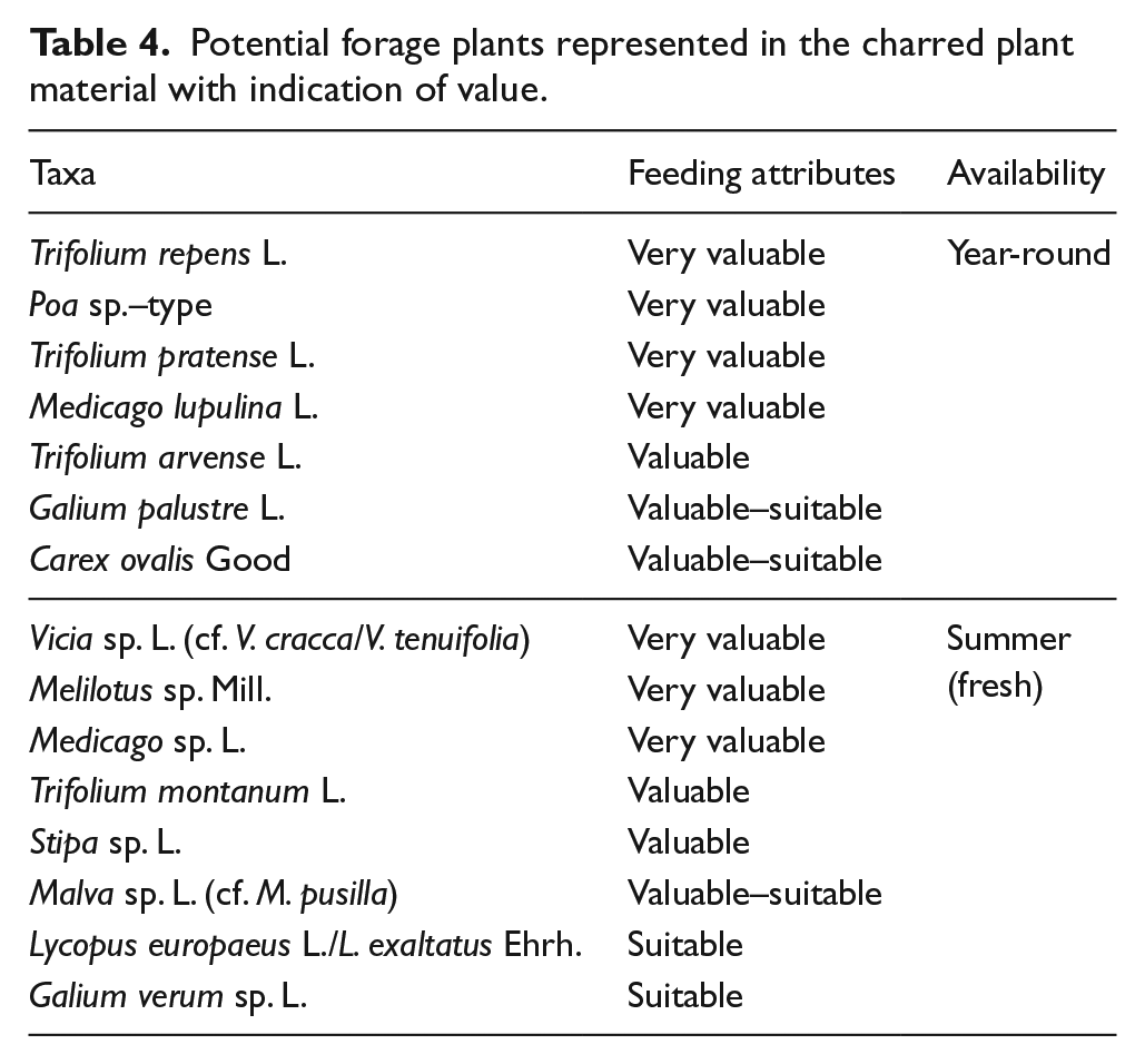
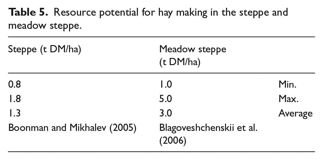
In general, year-round grazing is assumed for the Bronze Age (Epimakhov, 2010b) and was used as the basis in our model B. However, an important step in risk minimization, the (occasional) provision of fresh or dried fodder for sick or weak animals (calves/lambs, lactating cows/sheep) or in severe winters may have taken place. One rarely discussed aspect is hay making (see Boroffka and Mantu-Lazarovici, 2011), whereas large-scale hay making seems unlikely or unnecessary in the steppe region. Livestock housing is not documented in the archaeological record for Kamennyi Ambar either. Furthermore, historical documents indicate that traditional Kazakh pastoralists did not practice hay making before the 19th century but used river valleys as winter pasture instead (Guirkinger and Aldashev, 2016 and references therein). This is in accordance with our assumption that additional valuable forage was probably supplied from the meadow steppe. In our macrobotanical record, 27 of 70 taxa originate from this vegetation unit such as grasses, small-seeded Fabaceae and Vicia (Figure 9b and Table 4). One possible way of entry into the cultural layer of the settlement is as fresh cut forage or hay (cf. discussion in Rühl et al., 2015). This would also explain the function of sickles found in Sintashta graves and settlement contexts. Using such tools, 100 people could have cut 25 ha of meadow steppe within 1 day (Krünitz, 1773–1858b). Assuming an average productivity (Table 5), their hay yield would have been 75 t DM (dry matter) – enough to feed about 60 dairy cows for a period of 120 days (Krünitz, 1773–1858b). The vegetation distribution shows that this was easily possible within our autonomous economic activity zones.
Potential forage plants represented in the charred plant material with indication of value.
Resource potential for hay making in the steppe and meadow steppe.
Conclusion
Our results show that the sedentary Bronze Age Sintashta culture at the northern periphery of Central Asia developed in a relatively humid environment suitable for agriculture. The regional steppe vegetation was similar to the present one but appears to have been comparatively little affected by human activities, yet there is a certain increase in ruderal taxa relatable to land use. A broad spectrum of wild plants is present in the natural archives and in the cultural layers, pointing to a productive steppe vegetation. The requirements for farming were met; nevertheless, results of macro-remain analysis do not indicate that agriculture was part of the Sintashta economy. We could not find evidence for either cultivated plants or agricultural practices. By contrast, it can be concluded that the Bronze Age economy was mainly based on animal husbandry, supplemented by fishing and gathering of wild plants. Provided that the three settlements along the Karagaily-Ayat River were inhabited contemporaneously, the minimum radius of independently managed economic zones in the immediate surroundings was 4 km. Taking into account the estimated population figures of selected Sintashta settlements and the assumed animal numbers per capita for the Bronze Age, the results of vegetation mapping could show that the natural environment of the considered areas was suited to support a sedentary society of livestock herders. Even if the pastures were situated within the proximity of settlements, their high productivity acted as a buffer against overgrazing. Simultaneously, the short distances enabled the milking of cows.
The limitation of the Sintashta culture to the Transural region is believed to be the result of the prevailing environmental conditions in this region. The hilly landscape with perennial rivers and the proven humid climate probably contributed to the decision to favour cattle within the herd structure. The steppe provided valuable natural pastures and offered excellent conditions to sustain the livestock. Especially the meadow steppes could function as reserve pastures in dry years and prevented the shortage of fodder. The macro-remains and finds of sickles from the Bronze Age point to the harvest of hay or fresh cut fodder. The appearance of wells within Bronze Age settlements in the whole steppe zone could be one method to supply water for cattle during winter.
Footnotes
Acknowledgements
We are much obliged to the project coordinators, Ludmila Koryakova from the Russian Academy of Science in Ekaterinburg/Russia and Rüdiger Krause from the Goethe University Frankfurt/Germany for their steady encouragement during fieldwork and their helpful contribution in our discussions. We also remain grateful to our many Russian colleagues, in particular the excavators Svetlana Sharapova, Sonya Panteleeva, Natasha Berseneva and Andrey Epimakhov for the fruitful cooperation and support. We thank Tanja Zerl for assisting in statistical analyses and Doris Bergmann-Dörr for the preparation of pollen and geochemical samples.
Funding
This work was supported by the German Research Foundation (DFG) (KA 752/17-2, STO 720/2-3) within the wider project ‘Environment, Culture and Society of the Southern Urals in the Bronze Age: a Multidisciplinary Investigation in the Karagaily-Ayat Microregion, Russia’ (a collaboration between the Goethe University, Frankfurt and the Russian Academy of Science, Ural Branch, Ekaterinburg).