
Abstract
The early- and mid-Holocene deposits of the Lower Khuzestan plain at the north-eastern margin of the Persian Gulf have been investigated by means of facies analysis of sediment successions of undisturbed cores. Organic material and molluscs have been selected for dating by radiocarbon whereby possible contamination by hard-water effect is discussed. The results suggest that the Holocene transgression in Mesopotamia may have taken place later than generally accepted. Before ca. 7700–7900 yr cal. BP, the plain was characterized by mud-dominated fluvial systems. During the mid-Holocene, tides invaded the existing valleys, and the sedimentary environment shifted from fluvial to estuarine but not as extensively as has previously been suggested. The estuarine environments lasted for about 2000–2500 years until ca. 4850–5000 yr cal. BP when the seaward part of the plain was again characterized by widespread fluvial sedimentation.
Introduction
For many decades, the timing and extension of the Holocene transgression of the Persian Gulf in the Mesopotamian plain has been an important field of research and a key factor in our understanding of the archaeology of the Middle East. Most of the regional and international investigations have been undertaken in Iraq and along the Arabian coast as a result of the wealth of archaeological information in these areas. The coastal area of Iran, though covering the major part of the eastern coast of the Persian Gulf and part of the Mesopotamian plain, has scarcely been investigated except in some general works (e.g. Lambeck, 1996; Sarnthein, 1972) and in the regional investigations of Baeteman et al. (2004/2005) and Heyvaert and Baeteman (2007).
The objectives of this research are to constrain the timing of the initial inundation of the plain by the Gulf and to identify the sediment characteristics and depositional environments of early- and mid-Holocene age in Lower Khuzestan, SW Iran (Figure 1). These data will contribute to improve the understanding of the Holocene evolution of the Mesopotamian plain as a whole. The data, in turn, will provide the archaeological community with information about possibilities of settlement and activities of past societies. Absolute age determination by radiocarbon is essential to meet these objectives. The interpretation of 14C analyses, however, must be considered with caution in this area because the dated material may have been subject to different types of contamination, for example, by older carbonates supplied by both the Gulf water and river water. The recognition and understanding of the problems related to the carbon reservoir effect, discussed in this paper, contribute to more secure interpretations of chronology and of the depositional and environmental history.

General location of the study area in relation to the Persian Gulf and the neighbouring countries, including the location of the cited cities in the text.
The study area
The research area comprises the Shadegan wetland and its surrounding area (Figure 2). The western border is defined by the road from Khorramshahr to Ahvaz and is located between Khorramshahr in the south and Istgah-e Ahu in the north. The eastern border runs from Nim Istgah-e Mansuri (Mansuri on the map) in the north to Sar Bandar in the south (Figure 2). Both the rivers Karun and Jarrahi cross the area. The river Jarrahi drains into the Shadegan wetland. The Karun is the most important river of Iran and ends in the Arvand (Shatt al-Arab), which also receives water from the rivers Tigris and Euphrates. The annual average inflow of the Karun is more than the inflow of the Tigris and Euphrates rivers together (Reynolds, 1993). Moreover, most sediment input into the Arvand is provided by the Karun that is tidally influenced as far as Darkhovein (Figure 2) (Adib, 2010; Adib et al., 2010). The average tidal range along the coast is 2.5–4 m (United Kingdom Hydrographic Office (UKHO), 2004, Admiralty Tide Table, 2005; Yarshater, n.d.) and up to 3 m in the Karun (Adib, 2008).
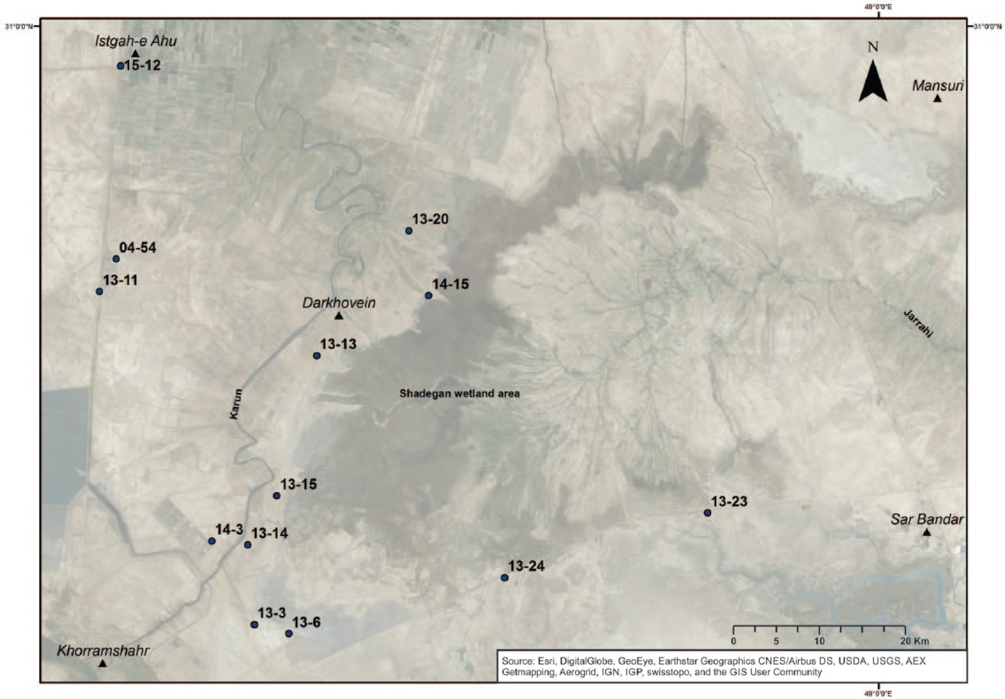
The study area and the 14C sample locations.
The morphology of the study area is for the greatest part flat with an altitude between +3 and +5 m m.s.l. (m.s.l. is the ordnance datum). The relief of the landscape increases towards the north and east and in the Shadegan area is locally as high as +8 m.
Previous research on changes in Holocene shoreline position
A generally accepted statement in the literature, first stated over a century ago (Evans, 2011), is that during the Holocene, the northern shoreline of the Persian Gulf has progressed inland due to sea-level rise and later on retreated as a result of the Mesopotamian delta formation. A few scientists held a contrary opinion. For example, Lees and Falcon (1952) and Hudson et al. (1957) attributed past changes in shoreline position to vertical tectonic movements. According to the reconstruction of Cooke (1987), the head of the Persian Gulf extended ca. 400 km farther inland into Iraq. This interpretation was also adopted by Sanlaville (1989) who considered an extension as far as Nasiriya–Amarah (Figure 1). This concept of a very extensive Holocene marine transgression across the Persian Gulf is still held today (e.g. Kennett and Kennett, 2006, 2007; Pournelle, 2003a; Sanlaville and Dalongeville, 2005). Indeed, Pournelle (2003a) drew the extension of the Gulf even further inland along a western branch as far as Samawa (Figure 1).
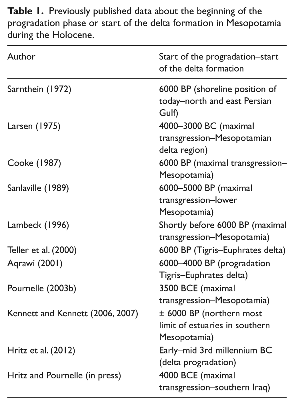
The maximum extension of the transgression followed by the onset of the progradation and/or the start of the Mesopotamian delta formation has been discussed by many researchers who apparently all agree that this happened around ca. 6000–5000 BP (summarized in Table 1). However, this view is based on very limited data, and there is almost no precise information on the chronology of the marine inundation nor of any regional variations in the timing of marine flooding. Gunatilaka (2011) dates the start of the transgression in southern Kuwait between 8540 and 7650 ± 70 yr BP (not calibrated). According to Aqrawi (2001), brackish–marine conditions were present in the vicinity of Fao–Abadan around 9000 yr BP and reached Basra at ca. 8000 yr BP. Hritz et al. (2012) describe that a marshy environment existed in southern Iraq from the 7th millennium BC till at least the 3rd millennium BC. It is estimated that sea level in the Persian Gulf had attained a level of about −64 to −61 m at ca. 12 ka, ca. −40 to −53 m at 9.5 ka and ca. −30 m at 9 ka (Sarnthein, 1972; Uchupi et al., 1996). According to Lambeck (1996) and Lokier et al. (2015), the present shoreline was reached shortly before 6000 years ago.
Previously published data about the beginning of the progradation phase or start of the delta formation in Mesopotamia during the Holocene.
Detailed information about the sea-level history of the Gulf is scarce in the literature. Dalongeville and Sanlaville (1987) describe sea-level fluctuations that reached an amplitude of 2.5–3 m between 6000 and 1000 yr cal. BC. More recently, Dalongeville et al. (1995) demonstrated similar fluctuations with the same amplitude between 6000 and 1000 yr BP. Sanlaville (2003) argued that the sea level reached its maximum of between +1 and + 2 m above present at ca. 4000 yr BC. However, the author refers to Lambeck (1996) who estimated this higher sea-level stand purely on the basis of numerical modelling. Clearly there is some ambiguity regarding the accuracy of these sea-level index points (Baeteman et al., 2004/2005) since the data are from different and widely spread coastal areas of the Persian Gulf characterized by different tectonic settings and by different isostatic and hydrostatic effects. In some cases, the inferred positions of higher sea-level positions are based on shell dates from beach ridges (Carter and Crawford, 2001) and are therefore inaccurate sea-level index points.
Information concerning sea-level changes in Iran is found in Baeteman et al. (2004/2005) and Heyvaert and Baeteman (2007). Heyvaert and Baeteman (2007) stated that around 8000 yr cal. BP (±7100 yr BP), the Persian Gulf extended 80 km more northwards than today along the Iranian–Iraqi border. The latter authors argued that a rapid Holocene sea-level rise in combination with a high sediment input caused frequent marine inundations, aggradation of tidal flats, salt marsh development and the development of a high groundwater table that existed until 7000 yr cal. BP (±6300 yr. BP) or perhaps later. The authors also describe that coastal sabkhas replaced the salt marshes landwards of the high intertidal flats and attributed this change to drier climate conditions. The onset to a later progradational phase took place around 2500–2400 yr cal. BP (Heyvaert and Baeteman, 2007).
Methods and material
Fieldwork
Fieldwork in the Lower Khuzestan plain was conducted in 2004 and 2009 and during three campaigns in the period between 2013 and 2015. Around 80 undisturbed cores with a maximal depth of 12 m were taken with a hand-operated gouge core. Characteristics including colour, texture, sedimentary structures, bedding plane characteristics, palaeontological remains, inclusions of evaporites, degree of consolidation and pedological characteristics were described directly in the field. Boreholes were located using a handheld Dakota-20 Garmin GPS with a maximal horizontal precision of 15 m, while the altitude was derived from topographic maps, climatological stations and Digital Elevation Model Shuttle Radar Topography Mission (DEM SRTM) data. Altitude data were calculated in relation to a reference datum which in Iran corresponds to mean sea level (http://www.trigtools.co.uk/datums.cgi?rows=1&cols=1).
Accelerator mass spectrometry dating
In this study, 18 samples were selected for radiocarbon analysis via accelerator mass spectrometry (AMS) at the Royal Institute for Cultural Heritage (Brussels) (Boudin et al., 2015). δ13C values of the molluscs were computed at the same institute. Dated materials are of ‘organic matter’, root remains and molluscs. The term ‘organic matter’ stands for dark brown to black material of plant origin mostly without any macroscopically identifiable remains. Although microbial mats (MMs) are composed of microorganisms, mainly bacteria and archaea, in practical terms they are incorporated in the term organic matter. MMs are known to be common in semi-arid and arid environments and are often the sole producers of organic matter. At present, they occur together with few small shrubs as the dominant producers of organic material in the uncultivated part of the Lower Khuzestan plain, especially in the southern area where during winter and spring water is collected in topographic depressions. The thickness of the ‘organic matter’ varies from a few millimetres to several centimetres; a thickness of more than 10 cm has exceptionally been found. The lateral extension of it is unknown because the distance between the drillings is several kilometres. The organic material occurs as lumps, patches or covers the whole (3 cm) width of the auger. In situ roots large enough for dating are rather scarce. Since ‘organic matter’ is limited, molluscs were also collected for dating.
Sources of error
Radiocarbon dating can yield erroneous ages because of the ‘hard-water effect’ especially with regard to dated aquatic organisms (fauna and flora). In our study area, located at the edge of the Persian Gulf where terrestrial and littoral environments meet, the Gulf water can be a source of contamination. Southon et al. (2002) documented a marine reservoir age (ΔR) of 190 ± 25 for the western Arabian Sea, located southeast of the Persian Gulf. However, the local effect from deep-water upwelling may be relatively weak because the Persian Gulf is a shallow depression with an average depth of ca. 35 m (Kämpf and Sadrinasab, 2006). Moreover, evaporation excess in the Persian Gulf exhibits a reverse circulation with a dense bottom outflow into the Arabian Sea and a surface inflow of Arabian Sea water (Kämpf and Sadrinasab, 2006; Southon et al., 2002; Yao, 2008). Thus, Yao (2008) concluded that the relative low saline water of the Arabian Sea propagates in two branches into the Persian Gulf, one along the Iranian coast towards the head of the Gulf and one towards the southern shallow banks. Two cyclonic gyres are formed; one in the north and one in the south of the Gulf. During spring and summer, the vertical mixing is suppressed by the stable thermocline, and inflow of surface water from the Arabian Sea extends far into the Gulf without significant modifications within the surface layer (Yao, 2008). During that period, the inflowing older water from the Arabian Sea will influence the age of living organism within estuaries, tidal channels and tidal flats. During autumn and winter, heat loss induces strong vertical water flows that cause continental and marine carbon to be mixed (Yao, 2008). The possible effect of older carbon coming from the Arabian Sea is reduced during that time of the year.
In addition to the impact of ‘old marine carbon’, the carbon dioxide in freshwater and/or river water may be altered by dissolved carbonates from geological origins (Ramsey, 2008; Törnqvist et al., 2015; Walker, 2005). This is the case in Lower Khuzestan where geochemical analyses of Karun river water show dissolved minerals from the Tertiary Formations present in its source area, the Zagros mountains (Zarei and Bilondi, 2013). The carbonates are most probably erosional products from the Agha Jari and Bakhtiari Formations and to a lesser extent from the Mishan and Gachsaran Formations present in the catchment areas of the rivers Karun, Jarrahi and Kupal. Consequently, molluscs that live within floodplain areas will incorporate older carbon within their shells.
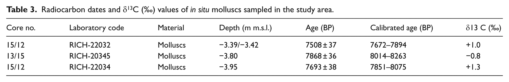
As a result of these dating uncertainties, all dated materials, both organic matter and molluscs, were sampled in terrestrial deposits, and therefore, the impact of a marine reservoir effect is considered as non-existent. On the other hand, there are undoubted inaccuracies associated with the dating of ‘aquatic terrestrial molluscs’. Because their reservoir age is yet not known for the Lower Khuzestan plain, the regional reservoir age correction ΔR of 190 ± 25 has been used in this study (Southon et al., 2002). It needs to be recognized that this reservoir age value is only an estimation but nevertheless the obtained age seems to fit the radiocarbon dating results obtained for the samples containing ‘organic matter’ (Tables 2 and 3). But as uncertainties remain, the use of molluscs as dating material is minimized.
Radiocarbon dates of organic matter.
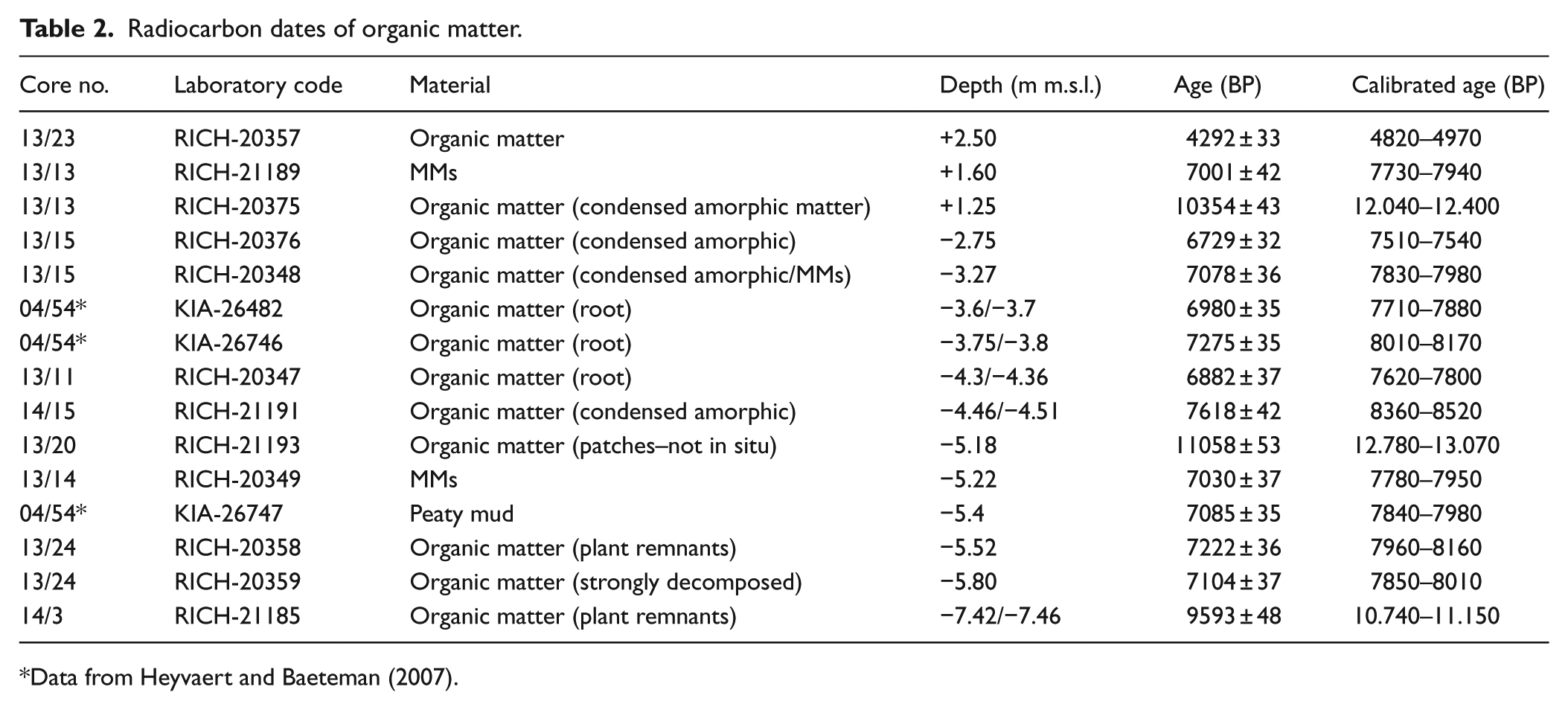
Data from Heyvaert and Baeteman (2007).
Radiocarbon dates and δ13C (‰) values of in situ molluscs sampled in the study area.
Calibration
All of the radiocarbon results are presented as conventional radiocarbon ages employing the Libby half-life method (Stuiver and Polach, 1977). The radiocarbon results of the ‘organic matter’ samples were calibrated using OxCal 3.1 and the IntCal13 calibration curve (Bronk Ramsey, 1995, 2001; Reimer et al., 2013). The aquatic molluscs were calibrated using Calib 7.1 and using the MARINE13 calibration curve with a reservoir age correction ΔR of 190 ± 25. Ages are given with a 2-sigma error range in calendar years.
Results
Detailed facies analysis of the sediment successions in the cores reveals the presence of terrestrial and tidal deposits. Samples collected for age determination were taken solely from the terrestrial deposits. The samples consist of remnants of vegetation and MMs (grouped together as ‘organic matter’) and, to a lesser extent, of molluscs.
Lithology and chronology of the deposits containing organic material
A differentiation within the sediment successions has been made on the basis of the presence of organic matter: (1) deposits below −2 m m.s.l. containing concentrations of organic material and (2) deposits above −2 m m.s.l. with scarce organic material.
The stratigraphy and sedimentology of the sediment successions below −2 m m.s.l. across the study area are essentially uniform. The dominant texture is silty clay, subordinate clay with a grey, less grey-brown colour. The deposits are macroscopically massive bedded apart from isolated sand and silt laminae. Mild oxidation appears locally as patches. The deposits are calcareous and enclose occasional macroscopically observable gypsum crystals. Complete gastropods and/or bivalves and gastropod fragments may be scattered over the unit. The datable material is composed of small beds and/or thick laminae of organic matter, most often preserved as an amorphic mass, roots a few centimetres long together with dark-coloured diffuse laminae of organic matter, patches and small lumps of organic litter. The bounding surfaces of the beds and laminae are both sharp and gradual. The clastic sediments enclosing the above-described organic material have been deposited by mud-dominated streams. The depositional features and soil characteristics suggest the presence of poorly drained alluvial plains with ponds and/or small shallow lakes. The lack of abundant organic remnants and the absence of sediment disturbance by roots exclude the presence of a marsh. The organic matter sampled between −7.4 and −2.5 m m.s.l. is dated between 10,740 and 11,150 and 7510 and 7540 yr cal. BP with a cluster in the interval 7750–8150 yr cal. BP (Table 2). On the basis of the complete dataset of radiocarbon dates in the study area, it seems that samples with similar ages are found at increasing depth in the sediment record towards the Persian Gulf.
Above the altitude of −2 m m.s.l., radiocarbon datable samples are scarce and the calculation of their age covers a large time interval, from 12,040–12,400 yr cal. BP to 4820–4970yr cal. BP (Table 2). The samples RICH-21189 and RICH-20375 were collected in strongly oxidized very stiff clastic material. The soil characteristics and the presence of small desiccation cracks are indicative of deposition associated with subaerial dry conditions. The host material of sample RICH-21189 is a massive clay and sample RICH-20375 is a clay with laminae composed of sand, vegetation detritus and black amorphic organic matter. It is precisely one of the amorphic matter containing lamina that was dated. The outcome was an age slightly older than 12,000 yr cal. BP. An age difference of around 4000 years (calibrated) is obtained for the MM (sample RICH-21189), situated only 35 cm higher in the sequence. The highest lying and also the youngest sample (RICH-20357, 4820–4970 yr cal. BP) was taken in the uppermost organic-rich horizon that is part of successive organic-rich horizons present in a 80-cm-thick deposit of grey silty clay to clay. The clastic deposit itself is massive bedded.
At first glance, the age and altitude of samples RICH-21189 and RICH-20375 (Table 2) are inconsistent because they are too old for their relatively high stratigraphic position. In respect of sample RICH-20375, a detailed sedimentary and geomorphological study has shown that this sample is part of an older fluvial environment that most probably covered a major part of the study area. As a result of an important erosional phase only remnants of these deposits are preserved. The relatively old age of RICH-21189, on the contrary, is due to the nature of the dated matter. MMs grow in all kind of environments, they only need a moist substrate (for a short period of time), an energy source and no or limited grazers (Eriksson et al., 2010; Handford and Fredericks, 1980; Rankey and Berkeley, 2012; Schrieber et al., 2007). Their presence may be the result of local conditions and these do not necessarily reflect regional environmental conditions. In this particular case, the age of the MMs gives no information about the depositional evolution of the area.
The mollusc containing deposits: Lithology, chronology and isotopic characteristics of the molluscs
All in situ collected molluscs were embedded in grey massive clay, except the mollusc in core 15/12 (RICH-22032), which occurred in silty fine sand interlayered with clay laminae. The sand was rich in gastropods. The in situ molluscs have an age between 7672–7894 and 8014–8263 yr cal. BP. A remarkable feature is the low positive, less low negative values of delta 13C‰ of all dated molluscs (Table 3). In general, a value close to 0‰ δ13C is obtained for marine shells (Taylor and Ofer Bar-Yosef, 2014). However, numerous studies (e.g. Fillippov and Riedel, 2009) have shown that variations in δ13C are related to changes in temperature and salinity and that the proximity of a marine environment is not essential. The salinity of the water of the Karun river increases markedly during the 4-km passage through the Gachsaran Formation in the Zagros mountains (Aghdam et al., 2012; Raeisi et al., 2013). Also in arid and semi-arid environments, high evaporation versus low precipitation may increase salinity in lakes, ponds and inundated areas till the level of marine water or even higher.
The existence of saline environments, ephemeral or perennial, during the Holocene in the Lower Khuzestan plain is proven by the presence of evaporitic minerals in the terrestrial subsoil and the joint appearance of snails like those of the genus Limnaea and Cerithidea cingulate although their common habitats are different. Cerithidea cingulate is known as a marine gastropod whereas Limnaea is a typical freshwater snail, but both tolerate brackish water conditions. The presence of Cerithidea cingulate in terrestrial deposits may prove that salinity may be the determining factor of their presence rather than the depositional environment. The ability to survive in an environment with fluctuating salinity is supported by the samples RICH-20345 and RICH-22034 that both exhibit different δ13C values of Cerithidea cingulate (−0.8 and +1.3‰, respectively).
Facies characteristics of the tidal deposits
The occurrence of deposits indicative of former tidal conditions is restricted to few valley fills and is constrained to the lower parts of the sediment cores. The sedimentological characteristics as well as the stratigraphy point to an estuarine depositional environment. Two typical depositional units with a tidal signature are observed. One unit consists of interlayered sets of silty clay, silt, clay and/or fine sand laminae and/or beds, and the other unit is composed of massive clay and silty clay sediments in which thin sand laminae and/or sand patches may be incorporated. Both units show bioturbation features that vary from scarce to abundant, in the latter case a sequence of several metres thick may exhibit evidence of disturbance. Deformation structures such as load casts and slump structures occur, but are not prominent. Shell fragments also occur, either scattered or concentrated in thin layers. The massive clay unit covers and/or interfingers laterally with the interlayered one. The top of the estuarine deposits generally occurs between −1 and +1 m m.s.l. The thalweg of the major estuarine channels has not been recovered. Towards the north of the study area and higher up in the sediment sequence, no tidally influenced deposits are present.
Discussion
The combination of the stratigraphic architecture and radiocarbon dating of the deposits in this part of Lower Khuzestan shows that at least from 10,740 to 11,150 yr cal. BP, the depositional processes were controlled by mud-dominated streams running in more than one valley coming out of the Zagros Mountains. Sedimentary, geomorphological and chronological results suggest that downcutting of these valleys happened shortly after 12,040–12,400 yr cal. BP, but before 10,740–11,150 yr cal. BP. Where the drillings went deep, the sedimentological characteristics indicate the presence of ephemeral and/or perennially poorly drained plains where vegetation, although not dense, and pools or very shallow lakes were common. These conditions suggest the former presence of moist soils and an ephemeral shallow groundwater level and local ponds with slowly receding surface waters. Along the Arabian part of the Persian Gulf, the groundwater level is determined, even near the coast, by precipitation and surface inundation, with only very limited horizontal landward movement of seawater (Evans, 2011; Robinson and Gunatilaka, 1991; Wood, 2011). As climatic conditions are similar along both sides of the Persian Gulf, the above-mentioned mechanism is most probably identical along the Iranian coast. Even, compared with the Arabian coast, the horizontal movement of seawater in the Lower Khuzestan plain will be reduced because of the very-fine-grained nature of the sediments.
The above-mentioned alluvial conditions lasted in the southern part of the study area at least until 7780–7950 yr cal. BP (core 13/14, Figure 2). In the same core, less than 1 m above the dated level of 7780–7950 yr cal. BP, intertidal deposits indicating the first signs of tidal activity are found. However, at this location, intertidal conditions appear to have changed rapidly into supratidal ones with the latter dominated further upwards in the sediment sequence when the area became out of reach of tidal activity. A similar age for the first tidal influence is found at the western margin of the study area where the top of the alluvial unit is covered by tidal deposits and dated to 7710–7880 yr cal. BP (core 04/54, Figure 2, Table 2).
An estuarine environment was only temporary because all sedimentological characteristics of the deposits higher than the altitude range of between −1 and +1 m m.s.l. indicate a progradation and the return of terrestrial sedimentation. It is very difficult to establish a precise age for the onset to predominant terrestrial sedimentation due to the absence of datable material. However, an approximate age is provided from core 13/23 from wetland sediments, of which the aggradation started before 4820–4970 yr cal. BP at the southern (seaward) margin of the study area (Table 2).
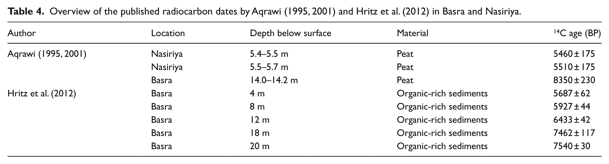
According to Aqrawi (1995, 2001), a brackish–marine environment was already present near Basra at 8350 ± 230 yr BP. It should be mentioned that Aqrawi (1995, 2001) used the presence of the foraminifera Ammonia beccarii and the ostracod Cyprideis torosa to define the marine–brackish depositional environment, but did not describe the sedimentological characteristics of these deposits. However, recent investigations in arid to semi-arid climatic environments reveal that the ostracod Cyprideis torosa occupies environments with a wide range of salinity ranging from freshwater to water with a conductivity level indicative of seawater (Mischke et al., 2012, 2014). Today, Cyprideis torosa lives as a monospecific population in the surface waters of the Timsah pond in Israel (Flako-Zaritsky et al., 2011). Also, the foraminifera Ammonia beccarii is observed in several lacustrine records in Israel (Almogi-Labin et al., 1995). Plaziat (1993) and Soulié-Märsche (2008) found Ammonia beccarii together with Cyprideis torosa in intercontinental lakes in North Africa, even at a distance of 900 km from the coast. Species found in Algeria have been observed with a high amount of charophyte gyrogonites which never occur in marine habitats or permanent saline water bodies (Soulié-Märsche, 2008). It is clear from the published literature together with the data presented here that palaeoenvironmental interpretations based on the presence of Ammonia beccarii and Cyprideis torosa in arid or semi-arid environments must be considered carefully because they do not provide exclusive information for one specific depositional environment. In this regard, the marine–brackish unit described by Aqrawi (1995, 2001), at least part of it, may have a continental origin and thus the age of 8350 ± 230 BP the author put forward for the beginning of the Holocene marine influence, may be too old.
Aqrawi (1995, 2001) has dated sabkha or intertidal deposits overlying the so-called brackish–marine deposits northwest of Nasiriya at a depth of 5.4–5.7 m to between 5510 ± 175 and 5460 ± 175 yr BP. Details about the depositional environment of these overlying deposits have never been described. Although Hritz et al. (2012) state that their radiocarbon results of Basra are consistent with those of Aqrawi (1995), it is clear that the samples deeper than 8 m are younger than 8350 ± 230 BP (Table 4). The dated samples near Basra presented by Hritz et al. (2012) were collected in a fluvial or marsh environment, while Aqrawi (1995, 2001) places the sample in a brackish–marine environment.
Overview of the published radiocarbon dates by Aqrawi (1995, 2001) and Hritz et al. (2012) in Basra and Nasiriya.
The data from southern Kuwait presented by Gunatilaka (2011) are interesting with respect to the southern Mesopotamian plain as a whole. There, the change from a braidplain environment to a shallow marine environment started at 8540 ± 70 yr BP in the most seaward area and progressed landwards until ca. 7650 ± 70 BP. Considering the time delay of the landward transgressive migration along the estuaries in the Lower Khuzestan plain, it may have been the case that both sides of the northern part of the Persian Gulf experienced most probably a coeval evolution. In Kuwait, progradation began in the landward area at 4730–4530 ± 60 yr BP (Gunatilaka, 2011). Our results show that this period corresponds with the approximate age (prior to 4292 ± 33 yr BP or 4820–4970 yr cal. BP) proposed for the seaward part of the Lower Khuzestan plain.
Conclusion
Detailed facies analysis of the sediment successions in the cores together with radiocarbon dates has made it possible to refine the timing of the initial inundation by the Persian Gulf and to establish the associated depositional environmental changes in Lower Khuzestan during the early- and mid-Holocene. Even if the dating is still imprecise, we can conclude that before ca. 7700–7900 yr cal. BP, the area was characterized by mud-dominated fluvial systems with poorly drained alluvial plains suitable for vegetation growth. In the mid-Holocene, the existing valleys were subject to a marine transgression. However, the spatial extent of the newly created estuarine environment was much more restricted than previously believed. Holocene estuarine sedimentation lasted for about 2000–2500 years between ca. 7700–7900 yr cal. BP and prior to 4850–5000 yr cal. BP. A more precise timing is not possible yet because of lack of datable material at the corresponding boundaries. Our data show that the Holocene transgression and hence the initial tidal influence as well as the progradation happened later than generally accepted and frequently described in the literature on Mesopotamia.
Footnotes
Acknowledgements
We thank Alastair Dawson for his constructive remarks and improving the English text. The authors are very grateful to the Geological Survey of Iran, Research Institute for Earth Sciences, in particular to Dr Razieh Lak for the logistic support during fieldwork, and to the Iran Department of Environment (Abadan Centre) for providing facilities such as guesthouse and general information. The field campaigns would not have been possible without the help of Javad Darvishi Khatoonabad and Reza Shahbazi.
Funding
This research is funded by the Interuniversity Attraction Poles Programme (IUAP 7/14) of the Belgian Science Policy.