
Abstract
Based on identification of fossil charcoals from 11 sites in the Hexi Corridor, we reconstruct the local vegetation community and human impact on it in the period from 4300 to 2400 cal. yr BP. More than 20 broadleaved taxa and 4 coniferous trees are present. The charcoal identifications show that vegetation in the period 4300–2400 cal. yr BP differed regionally because of variations in local topography and water supply, with limited diversity in the northwest Hexi Corridor and relatively rich diversity in the southeast area. In the northwest Hexi Corridor, the oasis woodland consisted mainly of Tamarix sp., Salix sp., and Populus sp. In the southeast region, the vegetation was a mix of coniferous forest and broadleaf woodland. By comparison with modern patterns of vegetation, broadleaf trees were much more abundant and the spruce forest extended down to relatively low altitudes, suggesting greater vegetation cover and richer diversity than today. There was also temporal variation. In the period from 4300 to 4000 cal. yr BP, woodland was relatively scarce, while the greatest diversity of plants appears in the period from 4000 to 3500 cal. yr BP, probably because of better moisture conditions at that time. After 3500 cal. yr BP, there was the appearance of woodland dominated by Morus alba, suggesting that cultivated trees may have played a key role in the lives of local people.
Introduction
The Holocene was a time of intensive human activities with increasing environmental impacts (Li et al., 2009, 2011; Ruddiman et al., 2008). Since the emergence of agriculture, terrestrial vegetation has been significantly changed, with alterations in land use and land cover, as well as a sharp increase in the human population (Bellwood, 2005; Ruddiman, 2003). A comprehensive understanding of the interaction between humans and their environment is of crucial importance in providing clues not only to ancient cultural responses but also in suggesting social adaption strategies to future climate change (An et al., 2005; Zhou et al., 2016). Therefore, the reconstruction of past vegetation is a significant scientific issue because it reveals how early human activities shaped landforms and the implications of these changes on paleoclimate (Carcaillet, 1998; Delcourt and Delcourt, 1987; Li et al., 2012a; Zhao et al., 2013; Zhou et al., 2012).
Located in the Gansu Province of northwest China, the Hexi Corridor formed a key part of the ancient Silk Roads, arguably one of the most important communication routes between East and West (Flad et al., 2010; Li et al., 2007; Zhou et al., 2016). For the Neolithic and Bronze Ages, a series of cultural assemblages has been identified in the Hexi Corridor, including the Majiayao, Qijia, and Siba cultures (Chen, 2012; Li et al., 2010a; Zhou, 2009). The archaeological remains include a large number of sites, with abundant and well-preserved plant remains. In addition, as the Hexi Corridor lies on the margin of the East Asian monsoon and is also influenced by the Westerlies, the region is highly sensitive to climate change (Chen et al., 2006, 2010; Shi et al., 2002). Therefore, the Hexi Corridor is an ideal place to analyze the impact of human activity on the environment through reconstruction of past vegetation patterns, as well as to determine the adaption strategies of Bronze Age and Iron Age peoples in an arid region.
Recent research on the prehistory of the Hexi Corridor has been generally focused on early agricultural activities and cultural exchange. Valuable information has been recovered on the Western Eurasian domesticates, especially wheat and barley, and their adoption and transmission, as well as on ceramics, herding, and other economic activities (Atahan et al., 2011; Barton and An, 2016; Cui et al., 2015; Dodson et al., 2013; Jia et al., 2013). As for vegetation reconstruction, paleoclimatic study based on pollen records has broadly established the Holocene vegetation succession and climatic variation in this region (Chen et al., 2006; Wang et al., 2013; Zhang et al., 2000; Zhao et al., 2009; Zhu et al., 2003). Yet, because of issues relating to the relatively low-resolution identification and also transportation of pollen, the local oasis woodland is hard to reconstruct. In addition, because of the scarcity of reliable plant remains, research related to prehistoric wood exploitation and its impact on vegetation in the Hexi Corridor is limited.
Fossil charcoal derived from archaeological contexts, being a direct record of exploitation of local woods by ancient people, has proved to be an effective way to provide insights not only into the local vegetation community but also human usage of plants (An et al., 2014; Cope and Chaloner, 1980; Cui et al., 2002; Figueiral and Carcaillet, 2005; Li et al., 2012a; Sun et al., 2013). Charcoal from archaeological sites is formed from the incomplete combustion of local plants, and its distinguishing anatomical characteristics permit further taxonomical identification (Carcaillet, 2007; Gaillard et al., 2008; McGinnes et al., 1974). By comparison with pollen records, charcoal can be a more precise diagnostic tool as it can be identified precisely to genus or species, thus adding further detail to studies of vegetation communities (Barakat, 1995; Birks, 2003; Knapp et al., 2015; Li et al., 2012; Ludemann, 2003; Scott, 2010; Scott and Damblon, 2010; Sun and Li, 2012). Unlike pollens which can be widely dispersed, ethno-archeological research, site catchment analysis, and the ‘Principle of Least Effort’ model suggest that charcoal remains come mainly from woods limited to ~5-km radius or 1-h walking distance from the site (Renfrew and Bahn, 1991; Shackleton and Prins, 1992). Thus, fossil charcoals can provide a precise archive of local vegetation and human exploitation.
In the Hexi Corridor, charcoals from Huoshiliang and Ganggangwa sites show that this area was once an oasis with trees and shrubs, quite different from modern desert conditions (Li et al., 2011). Between 4100 and 3860 yr BP, human activities associated with bronze smelting had a major impact on the vegetation (Li et al., 2011). Analysis of material from the Xichengyi site gives a clue to past plant use and environmental conditions (Wang et al., 2014). However, integrated research based on large-scale archaeological sites is needed to fully reconstruct the Bronze Age and Iron Age vegetation. In this paper, charcoal remains from eight archaeological sites, including two continuous cultural sequences, are identified and integrally analyzed. By means of floatation to obtain charcoal remains and taxa identification through a scanning electron microscope, as well as precise accelerator mass spectrometry (AMS) 14C chronology, we identify the woodland types and examine human impact on local vegetation in the period 4300–2400 cal. yr BP in the arid Hexi Corridor.
Study area
The Hexi Corridor, surrounded by the Heli, Longshou, and Qilian Mountains, is a long, narrow lowland with an average altitude ranging from 1300 to 3500 m a.s.l. (Jia et al., 2014; Li et al., 2011). Three main river basin systems, the Shiyang, Heihe, and Shule rivers, flow from the Qilian Mountains to the desert, mainly supplied by water from mountain snowmelt, and generating a large number of oases in their fluvial plains (Figure 1; Li et al., 2011).
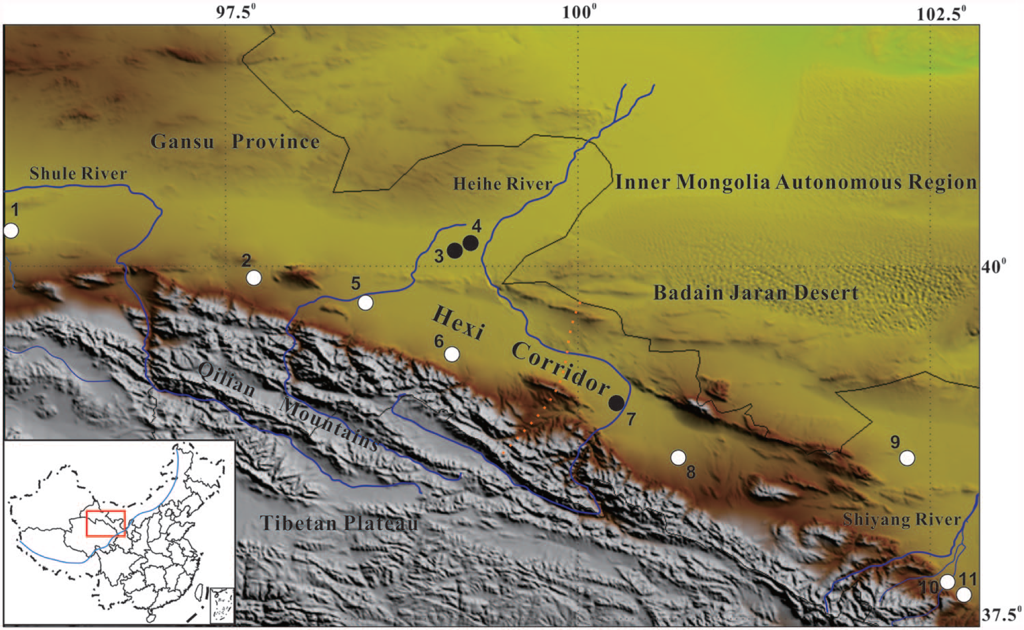
Location of 11 archaeological sites found in the Hexi Corridor.
As the Hexi Corridor is far from the ocean, it has an arid continental climate with a mean annual temperature range of about 4–9°C (Meng et al., 2013; Zhao, 1997). Modern precipitation, which plays a key role in regulating vegetation distribution, is transported by both the Asian monsoon and the westerly circulation, creating distinct regional differences (Wang et al., 2013). For the area influenced by the Asian Monsoon, annual precipitation can reach 550 mm. In the part affected by the Westerlies, annual precipitation is approximately 50–150 mm (Meng et al., 2013). However, annual evaporation in most regions can be about 2000–3000 mm. Rare rainfall and strong evaporation both cause such an arid climate that the local ecology is fragile and vulnerable to environmental change.
In general, because of the arid climate in the Hexi Corridor, the main vegetation type is that of temperate desert, dominated by Hippophae rhamnoides, Calligonum mongolicum, Tamarix ramosissima, Nitraria tangutorum, and Hexinia polydichotoma (Chinese Vegetation Editorial Board, 1980; Zhou, 2009; Figure 2). Steppe plants such as Stipa capillata and Cleistogenes are also common. For the driest Gobi region, Reaumuria songarica, Sympegma regelii, Kalidium cuspidatum, Krascheninnikovia ceratoides, and Caragana comprise the main flora. Sparse Populus euphratica and Elaeagnus oxycarpa occur in the midstream and downstream areas of the Shule River, while halophytic vegetation including Phragmites australis and Achnatherum splendens occupies the flood plains (Chinese Vegetation Editorial Board, 1980).
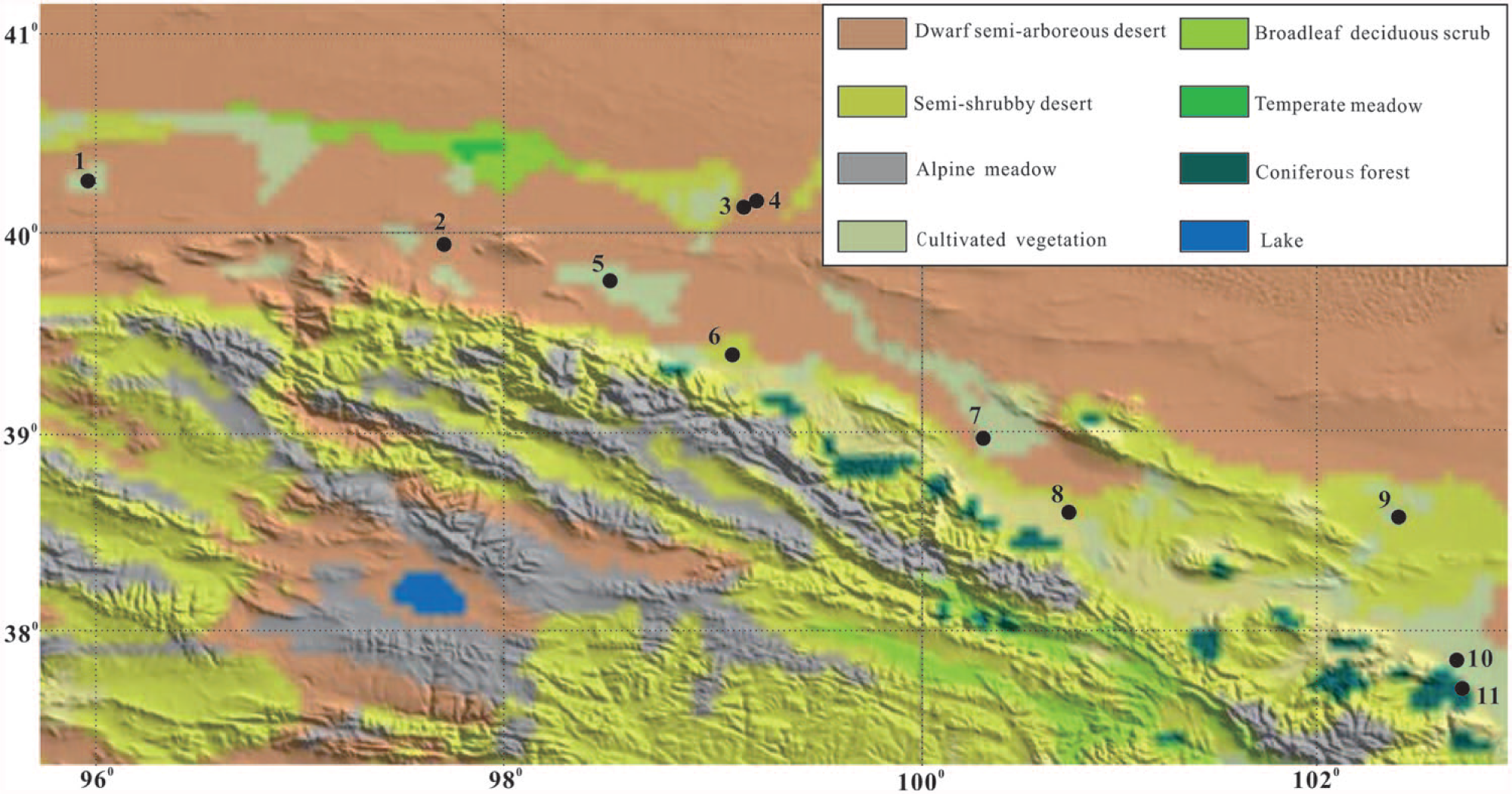
Modern vegetation of the Hexi Corridor.
Methods
A total of 11 archaeological sites have been selected for this study, covering most parts of the Hexi Corridor. Among them, two sites (Huoshaogou and Yingwoshu) are located in the Shule River basin; six (Huoshiliang, Ganggangwa, Zhaojiashuimo, Xihetan, Xichengyi, and Donghuishan) are in the Heihe River basin, and three (Mozuizi, Lifuzhai, and Sanjiaocheng) are in the Shiyang River basin (Figure 1). For eight sites, floatation has been used to acquire sufficient charcoal for identification. The charcoal data from the Huoshiliang and Ganggangwa sites is referred from our previous study by Sun et al. (2010) and Li et al. (2011), and the charcoal information from Xichengyi site is cited from the published paper by Wang et al. (2014).
For charcoal identification, three sections – transverse, radial, and tangential – are handmade and then metal-sprayed to allow clear images to be captured using a scanning electron microscope (ZEISS MA EVO25). Based on the anatomical features, including patterns of pipe, tracheids, resin canal, and ray parenchyma in each section, charcoal remains are classified to certain taxon with reference to the standard wood anatomy atlas (Cheng et al., 1992; Fahn and Werker, 1986; Zhou and Jiang, 1994).
An absolute chronology based on AMS 14C dating has been established for all sites (Dodson et al., 2013; Institute of Archaeology of Gansu Province, 1990; Zhang et al., 2015; Zhou et al., 2016; Figure 3). Three sites, Xihetan, Lifuzhai, and Mozuizi, dated to 4300–4000 cal. yr BP, are generally characteristic of the Machang phase (Majiayao culture; Li et al., 2010). More than half of the sites fall in the period 4000–3300 cal. yr BP and are related to the Siba culture. Only two sites, Sanjiaocheng and Zhaojiashuimo, associated with the Shajing culture, are later than 3300 cal. yr BP.
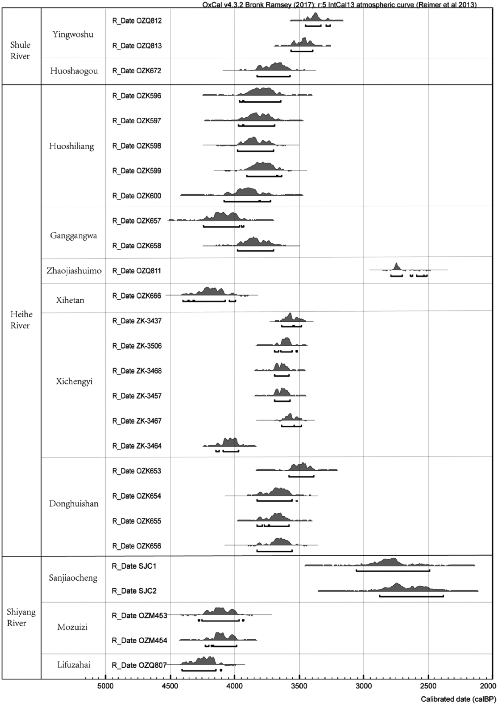
AMS radiocarbon dates (with 2σ error) for the 11 study sites.
Results
In this research, 3760 pieces of fossil charcoal from eight sites have been identified, with 4 coniferous trees and 23 broadleaf plants recognized. First, the abundance of each taxon and the broadleaf or conifer from each site were analyzed in order to define the vegetation type in the Hexi Corridor. Based on our analysis of the charcoal assemblages, the vegetation is divided into three types, oasis woodland (consisting of broadleaf), coniferous forest (with conifer accounting for more than 60%), and mixed vegetation (with broadleaf being the main wood and conifer occupying less than 10%). We also take the number of taxa found in each site as an indicator of plant diversity. With regard to vegetation change, three periods, 4300–4000, 4000–3500, and 3500–2400 cal. yr BP, could be distinguished. There are also clear differences between vegetation types in the northwest and southeast Hexi Corridor in each period, so these regions are described individually.
Period I (4300–4000 cal. yr BP)
To study the period from 4300 to 4000 cal. yr BP, charcoal remains have been selected from one site (Xihetan) in the northwest Hexi Corridor and two sites (Lifuzhai and Mozuizi) in the southeast part. In the northwest Hexi Corridor, coniferous forest developed near the Qilian Mountains as Picea sp., accounting for a percentage of about 64% of the total plants in Xihetan site (4300–4000 cal. yr BP; Figures 4 and 5). A small percentage of Vitex negundo (23%), Populus sp. (10%), and Salix sp. (2%) also occur (Figures 4 and 5).

Fossil charcoal assemblages from eight sites in this study: Xihetan (XHT), Lifuzhai (LFZ), Mozuizi (MZZ, four samples), Huoshaogou (HSG), Donghuishan (DHS, seven samples), Yingwoshu (YWS), Zhaojiashuimo (ZJSM), and Sanjiaocheng (SJC).
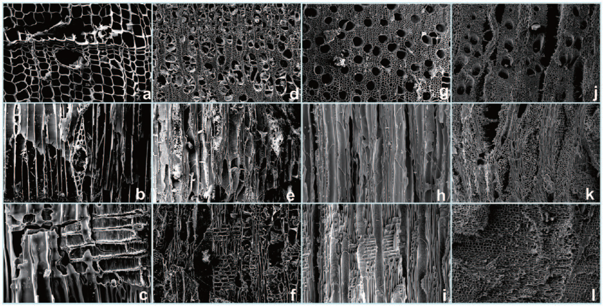
The anatomical characters of four common plants found in the Hexi Corridor: (a, b, and c) Picea sp., (d, e, and f) Populus sp., (g, h, and i) Salix sp., and (j, k, and l) Tamarix sp.
For the southeast Hexi Corridor, charcoal results show that mixed vegetation with both broadleaf woodland and coniferous forest developed in the period 4300–4000 cal. yr BP. In the Lifuzhai site dating to 4300–4100 cal. yr BP, Salix sp. and Juniperus sp. make up the dominant taxa, accounting for 26% and 20%, respectively (Figure 4). A few Quercus sp., Pyrus sp., and Betula sp. comprise the broadleaf trees, with a percentage of less than 2%.
Mozuizi site has a long cultural sequence dating from 4200 to 3900 cal. yr BP, where charcoals from 10 plants were found (Figures 4 and 5). Tamarix sp. is the sole shrub, maintaining a percentage of about 10% during this period. Broadleaf trees dominated by Populus sp., Rhus potaninii, Salix sp., associated with Pyrus sp., Sorbus sp., and Betula sp., account for more than 80% of the total woods. Conifers consisting of Picea sp. and Juniperus sp. with a proportion of less than 10% are also present. Fruit trees such as Padus sp. maintain a high proportion of the total, exceeding 55% throughout the whole cultural period.
Period II (4000–3500 cal. yr BP)
From 4000 to 3500 cal. yr BP, two sites have been selected for reconstruction of past vegetation patterns. In the northwest Hexi Corridor, oasis woodland was present in the Huoshaogou site in the period 3700–3500 cal. yr BP (Figure 4). About 200 fragments of fossil charcoal have been identified, showing that four woods including Populus sp., Salix sp., Fraxinus mandschurica, and Tamarix sp. were utilized by local residents. Among these plants, the first three share almost similar percentages of 30%, respectively, while the last one comprises less than 10%.
In the southeast Hexi Corridor, the Donghuishan site (3800–3400 yr BP) is the focus of this research because of its continuous cultural deposition of c. 140 cm in depth and good recovery of fossil charcoal. Previous research also shows that its agricultural activities exerted a great impact on the local environment (Zhou et al., 2012). A total of 7 samples were floated, and 1583 pieces of charcoal containing 19 taxa were recovered (Figure 4). There is a large portion of broadleaf shrubs (or herbs), including Chenopodiaceae with a presence at about 18% and a few Tamarix sp., Suaeda Forsk, Cotoneaster sp., and Acanthopanax sp., with a percentage of less than 5%, respectively. For the broadleaf trees, edible Padus sp. maintains the highest ratio of about 20% through most cultural layers. Salix sp. and Rhus potaninii represent about 4%, respectively, with a few Sorbus sp., Ulmus sp., Acer sp., and Populus sp., each taxon accounting for a percentage of less than 5% of the total. Of the coniferous trees, Picea sp. is the most common, making up 19% of the total charcoal, followed by Juniperus sp. (2%) and Taxus wallichiana (1%).
In addition, three zones could be identified in the Donghuishan sequence based on the number of taxa and the relative ratios of conifers, broadleaf trees, and shrubs (or herbs; Figure 6). Based on the age–depth model constructed by Zhou et al. (2012), each zone spans about one century. For the first zone, about 15 kinds of woods are identified. The percentage of conifers is around 15%, with a large number of broadleaf shrubs (or herbs; 42%) as well as broadleaf trees (36%). In the second zone, about 13 taxa are noted, and the proportion of conifers drops sharply from c. 36% to 5% throughout the sequence from the lower to the upper layers. Broadleaf shrubs (or herbs) increase to 54%, and broadleaf trees retain a similar proportion as in the first zone of about 36%. In the last zone, the number of taxa reaches its lowest level with only about 10 found in the latest layer. Conifers become dominant, accounting for nearly 65% of total woods. Broadleaf trees reduce from 54% to 29%, and broadleaf shrubs (or herbs) decrease from 36% to 22%. Eventually, the Donghuishan site was abandoned.
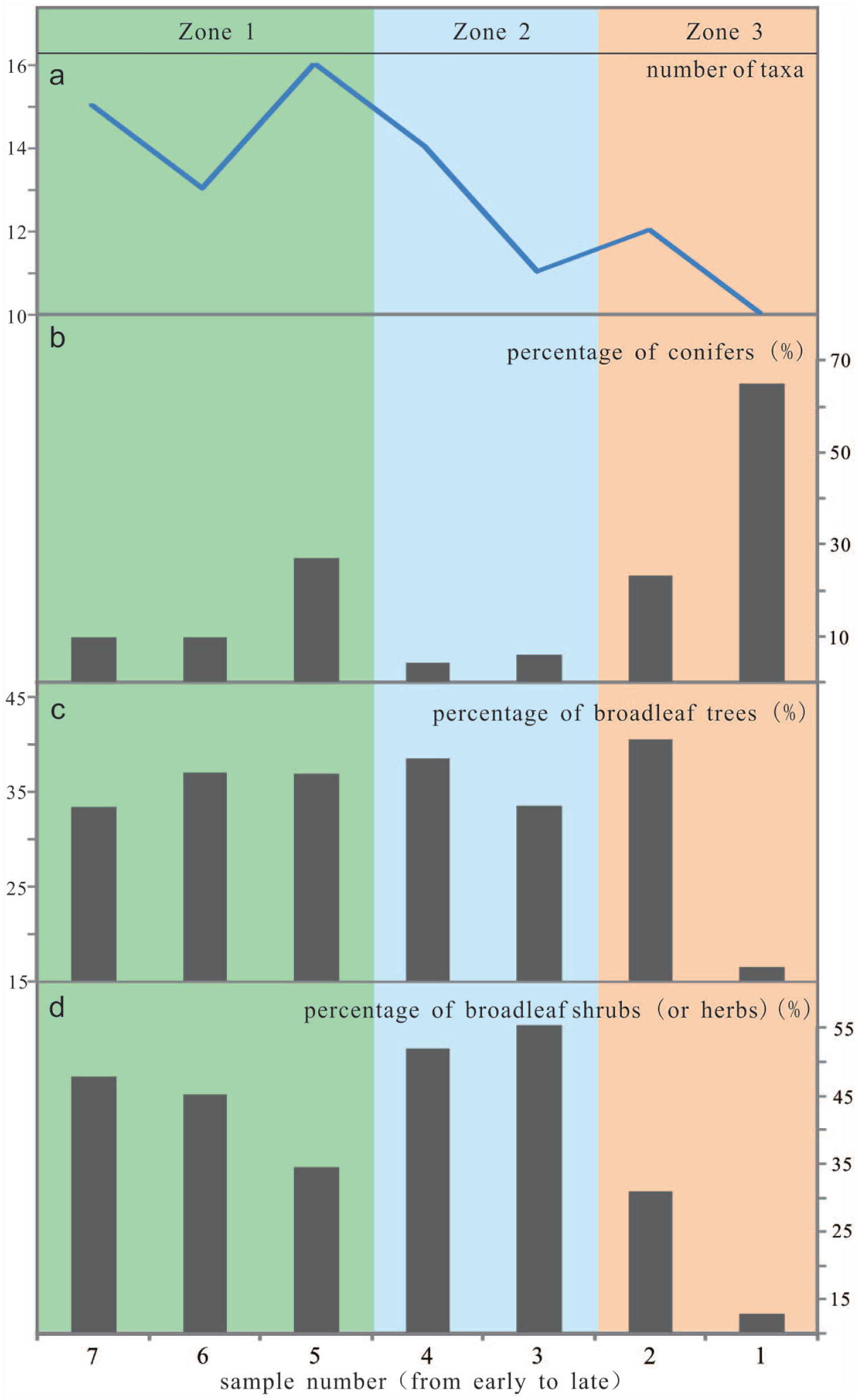
Three zones based on the percentage of conifers and number of taxa in the Donghuishan site: (a) number of taxa found in each sample, (b) percentage of conifers, (c) percentage of broadleaf trees, and (d) percentage of broadleaf shrubs (or herbs).
Period III (3500–2400 cal. yr BP)
After 3500 cal. yr BP, there is relatively limited vegetational diversity, and less than 10 taxa have been identified. There is also a marked change as most local plants present in the previous period disappear, except Tamarix sp., Salix sp., and Populus sp. which still remain in small numbers. In the northwest Hexi Corridor, Morus alba is found for the first time where it comprises more than 92% of the total charcoal remains in the Yingwoshu site (3500–3300 cal. yr BP; Figure 4). A small quantity of Populus sp. and Hippophae rhamnoides is also identified.
From 2700 to 2600 cal. yr BP, coniferous forest was still reflected well by the charcoal from Zhaojiashuimo site near the Qilian Mountains. Juniperus sp. represents more than 80% of all charcoal, and some Tamarix sp. and Betula sp. are also found with a percentage of less than 10%, respectively (Figure 4).
In the southeast Hexi Corridor, the evidence from Sanjiaocheng site, dated about 2600 yr BP, indicates mixed vegetation. Conifer is represented by Pinus sp., with a percentage of 4% of the total charcoal. The broadleaf trees, with Morus alba representing a percentage of more than 70%, show a pattern similar to the Yingwoshu site in the northwest of the Hexi corridor. There are also a small number of other plants including Salix sp. (9%), Tamarix sp. (7%), and Acer sp. (2%; Figure 4).
Discussion
Wood types and environment in the Hexi Corridor 4300–2400 cal. yr BP
Based on our charcoal analyses, we have been able to reconstruct three woodland types that developed in the Bronze Age and Iron Age (4300–2400 cal. yr BP). Nearly 30 taxa have been identified, with Tamarix sp., Populus sp., Salix sp., Betula sp., Acer sp., Ulmus sp., Quercus sp., Pyrus sp., Hippophae rhamnoides, Padus sp., Fraxinus mandschurica, Chenopodiaceae, Suaeda sp., Sorbus sp., Zygophyllaceae, and Cotoneaster sp. composing the main broadleaf assemblage. For conifers, Picea sp. and Juniperus sp. are the most common taxa, with a small number of Pinus sp. and Taxus wallichiana. Picea sp. favors moist, cool, shaded slopes, while Juniperus sp. often grows in open stands on warm, sunny slopes (Chen et al., 1994; Gao, 2011; Gou et al., 2012).
Among these woods, Tamarix, Populus, Salix, and Chenopodiaceae are xerophytic and are usually seen as an indicator of aridity (Zhang et al., 2003). Taxa including Betula, Padus, Pyrus, Picea, Acer, Juniperus, and Taxus wallichiana which often grow in a relatively humid habitat are usually taken as an indicator of relatively improved conditions of water supply (Editorial Board of the Vegetation Map of China, Chinese Academy of Sciences [CAS], 2001).
In the northwest Hexi Corridor, six sites are analyzed. Oasis woodland is found in four sites including Huoshiliang and Ganggangwa (Li et al., 2011; Sun et al., 2010) with a large amount of Tamarix sp. and a small proportion of Polygonaceae, Populus sp., and Salix sp. Among these oasis plants, drought-tolerant plants such as Salix sp., Populus sp., and Tamarix sp. comprise the most taxa, suggesting conditions of limited moisture. In all except one late site, Yingwoshu, Morus alba becomes the dominant plant for the first time. Coniferous forest, composed of Picea sp. and Juniperus sp., is associated only with two sites which are located near the Qilian Mountains.
By comparison with the northwest Hexi Corridor, a much richer wood diversity of nearly 30 taxa is found in the southeast Hexi Corridor, indicating better hydrothermal conditions. Charcoal assemblages from four sites in this research and Xichengyi site (Wang et al., 2014) show that mixed vegetation with both broadleaf woodland and coniferous forest was prevalent from 4300 to 2400 cal. yr BP. For the broadleaf woodland, the range includes trees such as Padus sp., Betula sp., and Sorbus sp. and xerophytic taxa including Chenopodiaceae, Tamarix sp., Populus sp., Salix sp., and Suaeda sp. Coniferous forests consist of not only Picea sp. and Juniperus sp. but also a small number of Taxus wallichiana, which usually grows in a relatively warm, humid environment, suggesting an abundant water supply in the southeast Hexi Corridor.
The clear regional differences in the prehistoric vegetation communities in the Hexi Corridor correlates well with variation in modern vegetation distribution and annual precipitation in this region (Chen and Pan, 2001; Wang, 2006; Figure 7). The southeast area, which can receive the Asian Summer Monsoon, is characteristic of a relatively abundant rainfall, with rich plant variety. In the northwest area controlled by the Westerlies, annual precipitation is rare, giving rise to vegetation dominated by desert plants. It can be suggested that the regional differences in vegetation identified for the late-Holocene were similarly influenced by the Asian Summer Monsoon and the Westerlies.
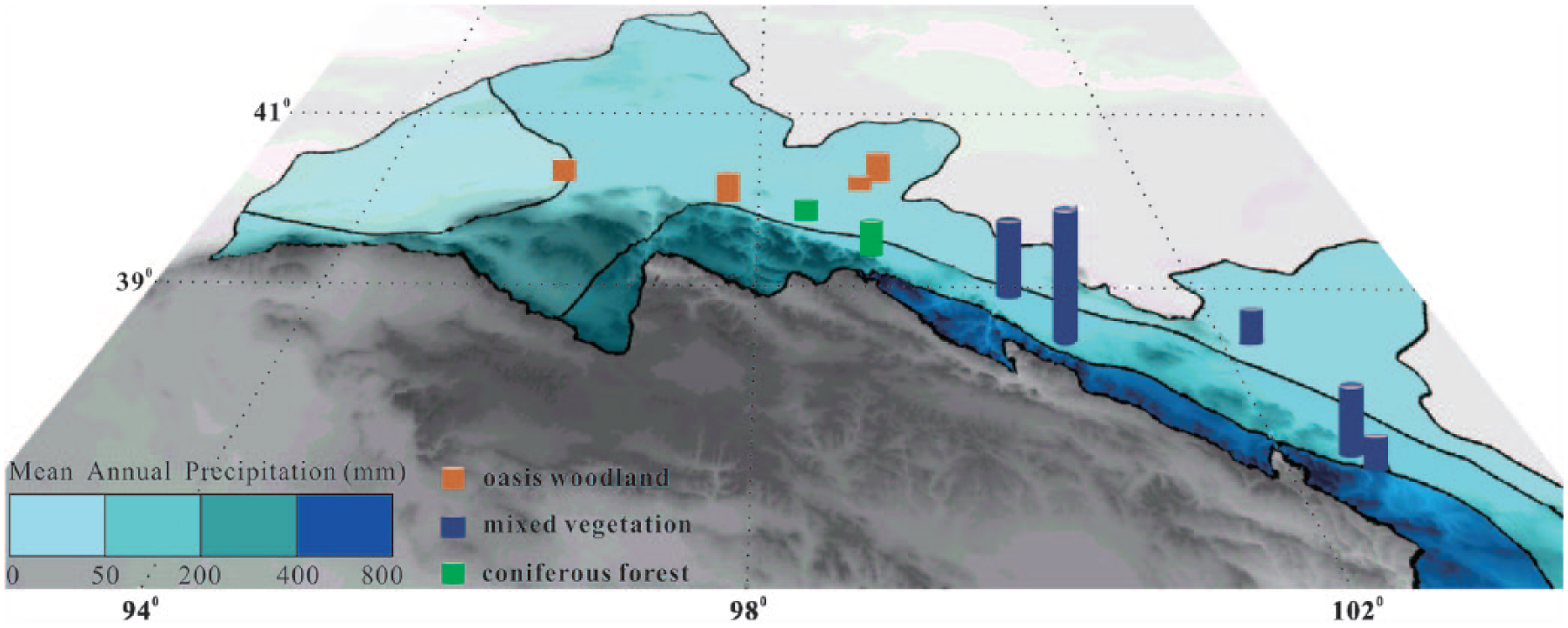
Map of modern mean annual precipitation and number of taxa found in each site.
Rainfall in the Hexi Corridor is also influenced by topography, specifically in relation to the Qilian Mountains, and this impacts on vegetation as well. The Qilian Mountains have high rainfall because of the uplifting of moist air and subsequent precipitation (Chen et al., 2012). Current research on precipitation in the Hexi Corridor suggests that the rainfall rate is strongly correlated to altitudinal change, with an increase in altitude matched by an increase in precipitation (Chen et al., 2012). This is reflected in a decrease in the number of taxa as the distance from the Qilian Mountains increases. Thus, precipitation differences linked to local topography also exerted influence on vegetation types and distribution during the late-Holocene.
In short, oasis woodland was prevalent in the northwest Hexi Corridor, with coniferous forest restricted to some areas near the Qilian Mountains. Mixed vegetation with both broadleaf woodland and coniferous forest make up the single wood type in the southeast area. Most of the taxa identified in this study are also found in the Hexi Corridor today. As with the modern arid climate, the abundant presence of these drought-tolerant plants suggests that the Hexi Corridor was generally dry from 4300 to 2400 cal. yr BP.
However, broadleaf woods, including Pyrus sp., Sorbus sp., and Acer sp., and coniferous tree such as Taxus wallichiana, which imply relatively humid and warm conditions, as in the southern Gansu Province, are found in the Donghuishan site. Picea sp. had also expanded into the relative low altitude areas, with a more extensive spread than today (Editorial Board of the Vegetation Map of China, Chinese Academy of Sciences [CAS], 2001). Thus, the fossil charcoal indicates that although the late-Holocene climate was generally arid, at times when moisture conditions improved, relevant hygrophilous plants would move northward to the Hexi Corridor or expand their distribution somewhat.
Vegetation succession in the Hexi Corridor
With regard to chronological variation in vegetation, the regionally differing woodland communities in the northern Hexi Corridor and the southern Hexi Corridor should be considered separately. For the northwest region, from 4300 to 4000 cal. yr BP, about five taxa were found, and the abundance of xerophyte remained at a low level in the area near the Qilian Mountains. In the period 4000–3700 cal. yr BP, five plants were present, and the xerophyte reached its highest level and then slightly declined from 3700 to 3500 cal. yr BP (Figure 8). After that, the xerophyte decreased sharply and was partly replaced by Morus alba. Morus alba favors a humid habitat and occurs mainly in east China (Editorial Board of the Vegetation Map of China, Chinese Academy of Sciences (CAS), 2001). In this study, it was identified for the first time in the arid Hexi Corridor. The sudden occurrence of mulberry trees around 3500 cal. yr BP, with a percentage of nearly 93% of total charcoal, seems to imply that local people started cultivating the mulberry tree in the oases.
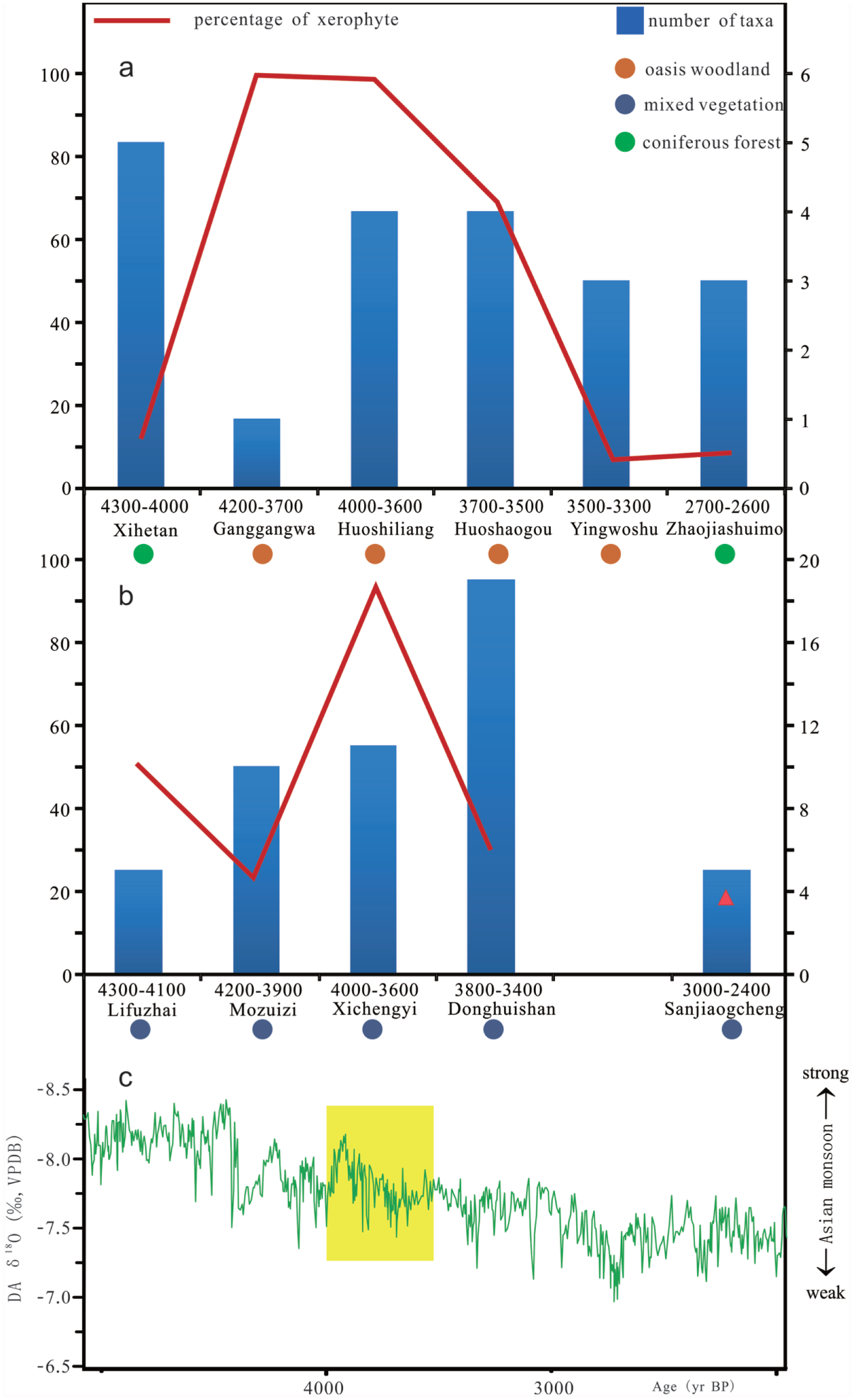
Variation of wood assemblage and Asian monsoon during the late-Holocene. (a and b) Number of taxa and the percentage of the xerophyte for each site in the northwest and southeast Hexi Corridor. (c) Oxygen isotope ratio (δ18O) of the stalagmite from the Dongge Cave suggests changes in the amount of precipitation and Asian monsoon intensity (Wang et al., 2005).
In the southeast Hexi Corridor, mixed vegetation represented the single woodland type. In the period 4300–4000 cal. yr BP, the average number of taxa was about seven, but the percentage of xerophyte was high, reaching about 36% out of all charcoals. From 4000 to 3500 cal. yr BP, plant diversity increased rapidly, reaching about 20 plants. However, after 3000 cal. yr BP, as in the northwest part of the Hexi Corridor, the proportion of xerophyte decreased because of the increase in the wood assemblage dominated by Morus alba (Figure 8).
As for the increase in plants that occurred from 4000 to 3500 cal. yr BP, especially for the abundant taxa found in Donghuishan site, we speculate that it is likely to have resulted from improved water and thermal conditions. A growing body of research shows the weakening of the Asian summer monsoon after 5000 cal. yr BP, associated with spells of wetter conditions in the Hexi Corridor and the surrounding area (Herzschuh et al., 2004; Li et al., 2012; Long et al., 2010; Wang et al., 2013; Yu et al., 2006; Zhang et al., 2000). Paleoclimate proxies from the Biandukou section reveal a strong combination of temperature and moisture from 3800 to 3400 cal. yr BP (Yu et al., 2006). Stalagmite records during this period from Dongge Cave showed an increased amount of precipitation and relatively strong Asian monsoon at about 3800 cal. yr BP, gradually weakening from then on (Wang et al., 2005). This pattern is also supported by the pollen records from the SJC section (Chen et al., 2006) and the Hongshui River section (Zhang et al., 2000).
Human impact on vegetation
From 3800 to 3500 cal. yr BP, the charcoal data show a trend of obvious decrease in woodland diversity and a great variation in the broadleaf/conifer ratio. In the Donghuishan site, the number of taxa rises to 15, and the broadleaf comprises more than 90% of total woods in the earliest layer. By the latest layer, only 10 plants are found and broadleaf trees decline significantly while conifers account for 65%.
The variation in the wood assemblage suggests that people initially exploited the woods closest to the settlements. The conifer has a low growth rate and is slow to become reestablished following deforestation (Gao et al., 2000; Li et al., 2012). When it was exhausted as a wood resource, local broadleaf became the main source of firewood. Later still, when all local woods became scarce, people started to exploit the distant montane conifers up until the site was abandoned. Therefore, we infer that human activity may have played a key role in local vegetation change. This is supported by current research which shows a rapid agricultural transformation from common and foxtail millet crops to wheat and naked barley during this period (Zhou et al., 2012). Such high-yield agriculture relying heavily on irrigation would have resulted in land degradation which might finally cause a decrease in agricultural activities and the eventual abandonment of these settlements (Zhou et al., 2012). Elements of geochemistry and fossil charcoal records have revealed a high demand for charcoal for bronze smelting, and this may also be responsible for the disappearance of certain woods at that time (Li et al., 2010a, 2010b, 2011).
In addition, the large proportion of fruit trees including Padus sp. and Pyrus sp. identified in the Donghuishan and Mozuizi sites appear to indicate a conscious selection and management of certain woods. This, to a large extent, would lead to a shift of the woodland community toward one influenced by human activity. After 3500 cal. yr BP, the cultivation of Morus alba also suggests that the vegetation community was shaped by human activities.
Finally, 11 sites in this research have only 0.5–1 m thickness of cultural deposits, with only one period of occupation lasting two or three centuries. This is in marked contrast to typical monsoon-influenced areas in east Asia, where cultural layers are normally 2–4 m thick, representing a continuously settled period of a thousand years or so (Bureau of National Cultural Relics, 2014; Zhou et al., 2016). Over the period of settlement in the Hexi Corridor sites, local plant diversity decreased rapidly until the site was abandoned, suggesting that local ecology was very sensitive to human impact. Wood resources may just have been sufficient to supply two to three centuries of human exploitation in the arid Hexi Corridor. Once the local timber resources became stressed, people may have had to look for new places to settle in other unexploited oases.
Conclusion
Fossil charcoal analysis from 11 archaeological sites reveals oasis woodland associated with a small area of coniferous forest in the northwest Hexi Corridor. For the southeast region, the charcoal samples show mixed vegetation consisting of both coniferous forest and broadleaf woodland. The regional differences in the prehistoric vegetation communities were influenced by differences in precipitation patterns linked to the relative impacts of the Asian Summer Monsoon and the Westerlies, as well as proximity to the Qilian Mountains.
There are also indications of relatively minor fluctuations in climate resulting in occasional northward spread of hygrophilous plants. From 4000 to 3500 cal. yr BP, better moisture conditions seem to have contributed to a much richer plant diversity, yet the vegetation community reduced rapidly during this period, most likely due to human activities concerned with either bronze smelting or intensive agricultural transformation. After 3500 cal. yr BP, abundant Morus alba first appeared in the Hexi Corridor, suggesting that people may have started to cultivate the mulberry tree.
Footnotes
Acknowledgements
The authors thank the two anonymous reviewers and John Dodson for their constructive comments and suggestions. They also thank Nan Sun for her help with the charcoal identification.
Funding
This work was supported by the National Basic Research Program of China (2015CB953803) and National Natural Science Foundation of China (41372175 and 41371003).