



Abstract
To understand the early- to mid-Holocene vegetation and climate dynamics on the eastern coast of the Yellow Sea, we obtained a sedimentary core with high-resolution accelerator mass spectrometry (AMS) carbon 14 (14C) data from the Gunsan coast in South Korea. The palynological analysis demonstrated that the riverine wetland meadow from 12.1 to 9.8 cal. kyr BP changed to temperate deciduous broad-leaved forest in 9.8–2.8 cal. kyr BP. In addition, the cold climate from 12.1 to 9.8 cal. kyr BP became warmer from 8.5 to 7.3 cal. kyr BP. This was followed by another relatively cold period from 7.3 to 2.8 cal. kyr BP. The temperature change was mainly in response to solar factors. However, there are two relatively humid periods from 12.1 to 9.8 and 8.5 to 7.3 cal. kyr BP, which arose for different reasons. The earlier humid period resulted from strong westerlies and a rapidly rising sea level. The later humid period was produced mainly by the strong East Asian summer monsoon (EASM) and may also be linked to La Niña–like activity. The cold ‘Younger Dryas’ event from 12.0 to 11.4 cal. kyr BP recorded in this study may have been produced by a North Atlantic meltwater pulse. This would have reduced temperatures that were already low because of weak insolation, and the strong winter monsoons would have increased the precipitation.
Introduction
The northern East Asian summer monsoon (EASM) is very complex (e.g. Goldsmith et al., 2017a, 2017b; Liu et al., 2017; Stebich et al., 2015; Zhou et al., 2016b), and it is likely that δ18O records from Chinese caves do not accurately represent northern EASM rainfall (Liu et al., 2017). Even the accepted beliefs of a wet climate following a strong EASM and a dry climate following a weak EASM (Hong et al., 2005), together with a mid-Holocene precipitation maximum for northern EASM, have been challenged (Stebich et al., 2015).
The mechanisms controlling the Holocene EASM remain unclear. Some studies suggest that the main factors involved are solar output at the decadal to centennial scales and the Atlantic meridional overturning circulation at the millennial scale (Dykoski et al., 2005; Wang et al., 2005). Other research suggests that coastal areas may be influenced by changes in El Niño-Southern Oscillation (ENSO) at the centennial to orbital timescales (Jia et al., 2015; Lim et al., 2017; Lim and Fujiki, 2011; Park et al., 2016; Wu et al., 2012; Yang et al., 2014). Stebich et al. (2015) suggested that the combined monsoon precipitation and insolation-driven changes in temperature determined the environmental dynamics in northeast (NE) China at the suborbital to orbital timescales. At similar timescales, Park (2017) has suggested that solar and tropical ocean activities have driven late-Holocene climate change in the coastal regions of northern East Asia. Therefore, to understand the Holocene EASM changes and their underlying mechanisms, more studies will be required.
The eastern coast of the Yellow Sea is a significant geographical location relative to the northern EASM because it separates the Yellow Sea from the Korean Peninsula (Figure 1). Many studies have focused on the eastern coast of the Yellow Sea (Jang et al., 2006; Jun et al., 2010; Yi, 2011; Yoon and Jo, 1996), and the vegetation is suitable for investigating links between climate change and the EASM (Yi, 2011). However, because of a lack of quality data, changes in Holocene vegetation and climate dynamics on the eastern coast of the Yellow Sea require more research.
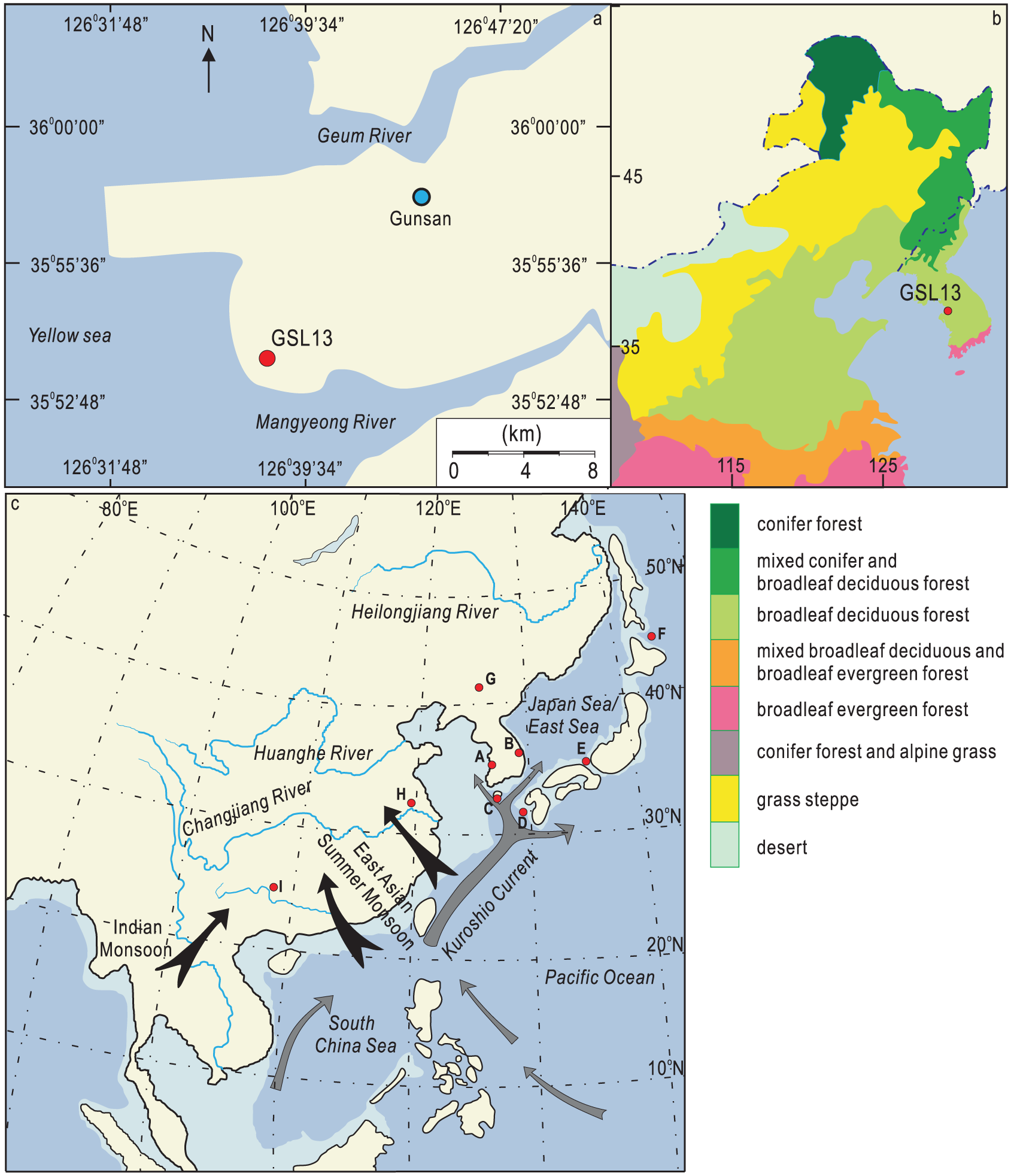
Map showing the study area. (a) The location of the GSL-13 core. (b) The natural vegetation of northeast (NE) China, North Korea and South Korea (data revised from Stebich et al., 2015 and Yi, 2011). (c) Map of the East Asian monsoon region and surrounding area (modified from Li et al., 2006): A, this study; B, Daeya Cave, South Korea (Jo et al., 2011); C, Hanon Maar, Jeju Island (Park et al., 2014); D, KY07-040-1, northern East China Sea (ECS; Kubota et al., 2010, 2015); E, Lake Suigetsu, Japan (Nakagawa et al., 2003); F, PC6, northwestern North Pacific (Minoshima et al., 2007); G, Sihailongwan Maar Lake, NE China (Stebich et al., 2015); H, stalagmite in Hulu, China (Wang et al., 2001); I, stalagmite in Dongge Cave, China (Dykoski et al., 2005).
In this study, we performed an early- to mid-Holocene palynological analysis of a sedimentary core from Gunsan in South Korea, which is on the east coast of the Yellow Sea. We identified pollen to characterize the vegetation and climate in the area. Accelerator mass spectrometry (AMS) was used to obtain carbon 14 (14C) dates, establish a relatively high-resolution temporal framework for changes in vegetation and climate, and elucidate the factors that might trigger and/or control these changes.
Regional setting
Geomorphology and hydrology
We studied the coastal region near Gunsan, which lies at the mouth of Mangyeong River (Figure 1). The Mangyeong River is 77.4 km long and has a basin area of 1527 km2 (Kang and Yeo, 2015). The riverbed slope is 1/3800 at the lower downstream section. The mouth of the river is characterized by a wide tidal flat to the south and a narrow tidal flat to the north. The area we focused on had a macro-tidal range with a spring (neap) tidal range of 6.6 (5.0) m (Lee and Ryu, 2008; National Oceanographic Research Institute, 2005, 2006). The bed of the main Mangyeong River stream consists of silt and clay in the downstream section and sand with gravel in the upstream section (Kang and Yeo, 2015). Sand is distributed as radiating tidal sand ridges from the river mouth and the nearshore (Korea Ocean Research and Development Institute (KORDI), 1999; Lee and Ryu, 2008). The land on the floodplain has been cultivated; therefore, the uppermost 2 m of sedimentary cores obtained from this area would have been disturbed.
Climate and vegetation
The annual average precipitation is 1100–1300 mm and is largely regulated by the EASM climate, with approximately 70% of this rainfall occurring during the summer rainy season (Choi et al., 2013; Lim et al., 2012; Figure 2). The annual average temperature varies from 10°C to 15°C (Figure 2). The coldest time of year is December and January, and the warmest is July and August. The vegetation is temperate, deciduous, broad-leaved forest (Yi, 2011; Yim and Kira, 1975). Recent vegetation in the coastal area is characterized by forests of pine and oak trees, dominated by Pinus densiflora, Pinus thunbergii, Quercus variabilis, Quercus mongolica, Quercus serrata, Quercus dentate, Quercus acutissima and Carpinus turczaninovii (Oh and Rho, 2013). There are salt marshes, which support the growth of Angelica utilis, Salicornia herbacea, Suaeda japonica and Phragmites communis (Oh and Rho, 2013). Naturalized herbs grow along the coast, including Rumex crispus, Panicum dichotomiflorum and Aster pilosus (Oh and Rho, 2013).
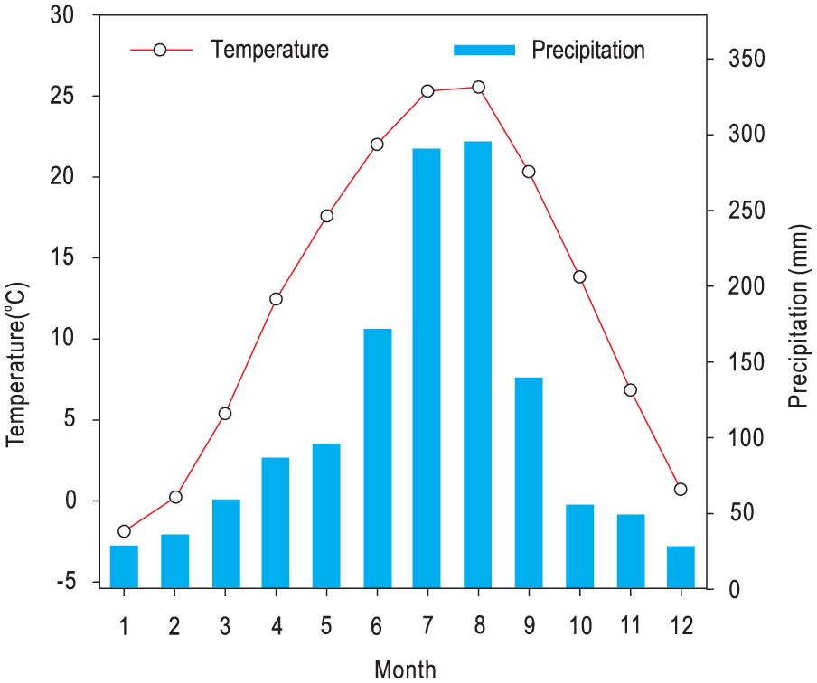
Average temperatures and precipitation data from the region of interest between the years 1971 and 2000.
Materials and methods
The GSL-13 core was obtained at latitude/longitude of 35°53′49″N/126°38′14″E and at an elevation of 3.11 m. The sedimentary environments were estuarine mouth and coastal with depths of 37.8–4.8 and 4.8–2.7 m, respectively. The uppermost region consisted of surface soil (Figure 3; Song et al., in preparation). In this study, we focused on that part of the core from 37.75 to 3 m in depth. The core was split, photographed and 94 subsamples were taken for pollen analyses at the Korean Institute of Geoscience and Mineral Resources (KIGAM). The intervals were approximately 50 and 25 cm at a depth of 26–3 and 37.8–26 m, respectively. In addition, the thickness of each sample is approximately 2 cm. Approximately 12–15 g of dried material from palynomorph samples was examined using an equal-volume sampling method. Pre-treatment and identification of micropalaeontological samples were performed at the KIGAM. All the samples were chemically treated according to the procedure outlined by Faegri and Iversen (1989). Weighed, dried samples followed by exotic Lycopodium spores were added to allow the concentration of palynomorphs to be calculated. The samples were treated with 15% hydrochloric acid, 45% hydrofluoric acid and 15% sodium hydroxide to prepare the palynomorph spectra and then sieved through a 10-µm mesh to remove small particles. Pollen, fern spores (FS) and freshwater algae (FA) were identified using a Nikon microscope at 400× or 620× magnification. All sample counting was completed using at least two slides, and most contained more than 200 pollen grains. We excluded 20 samples with less than 100 pollen grains. To identify the samples, we used information on modern and fossilized pollen from the State Key Laboratory of Palaeobiology and Stratigraphy at the Nanjing Institute of Geology and Palaeontology, Chinese Academy of Sciences, and reference plates from the Academia Sinica: Institute of Botany (1976; Academia Sinica: Institute of Botany and South China Institute of Botany, 1979).
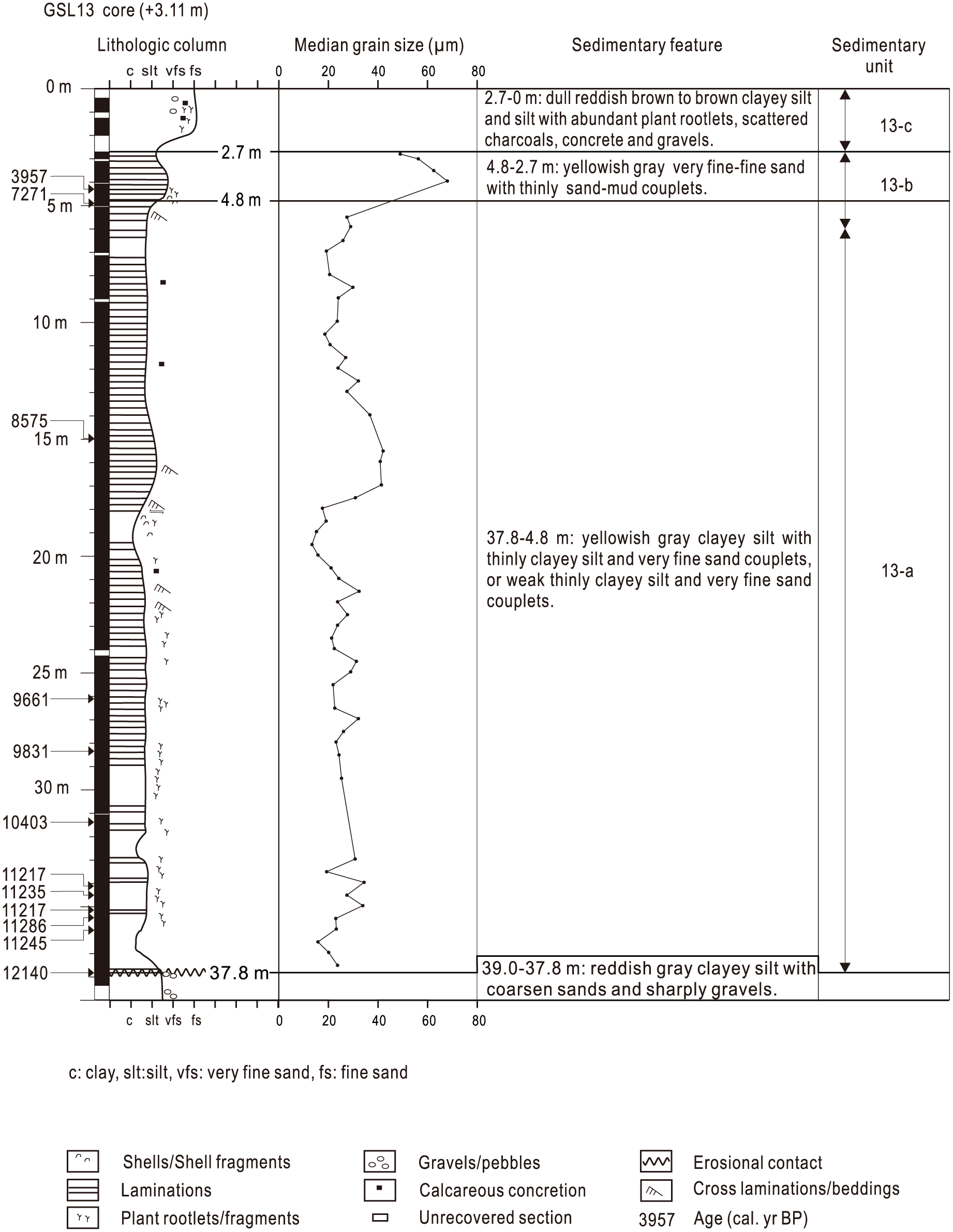
Lithological column and sedimentary units from the GSL-13 core.
The cores were subsampled at approximately 49-cm intervals, and samples 1 cm thick were used to analyse grain size. The grain sizes were measured using a Mastersizer 3000 laser particle analyser (Malvern Instruments, Ltd, Malvern, UK), and median grain sizes were calculated.
Mollusc shells and plant fragments were detected and dated using the AMS 14C radiocarbon method at the KIGAM (Table 1). The Calib program version 7.0.4 (Stuiver et al., 2014) was used to calibrate all the radiocarbon ages. Radiocarbon ages of terrigenous plant remains and marine molluscs were calibrated using the INTAL13 tree-ring dataset and the MARINE13 dataset, respectively (Reimer et al., 2013). We used a ΔR value obtained from the nearby coast and a value of −111 ± 45 years (Kong and Lee, 2005) in this study. All age data were recorded in calibrated years before present (cal. yr BP).
Summary of radiocarbon ages obtained from the GSL-13 core.
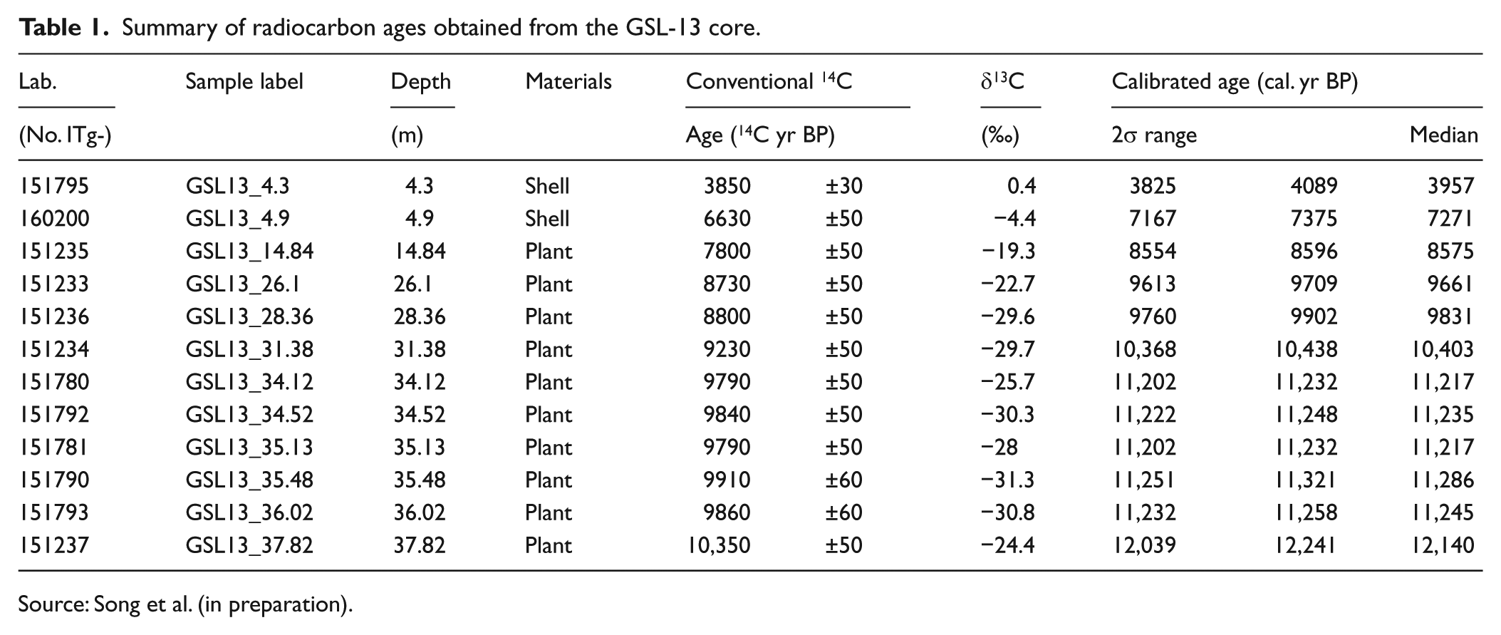
Source: Song et al. (in preparation).
Results
Chronological controls and sedimentation rate
In total, 12 AMS radiocarbon dates were obtained from the GSL-13 core. These were from 10 plant fragment samples and two shell samples (Table 1). The age data provided a chronology for the core. Using the age and depth data, we constructed a chronological framework based on the linear relationship between age and depth (Figure 4). However, we did not include the effects of sediment compaction or basin subsidence. The sedimentation rate fluctuated over different periods of time. The highest and lowest sedimentation rates were 3.18 and 0.02 cm/yr between 11,245 and 11,217 and 3957 and 7271 cal. yr BP, respectively (Figure 4).
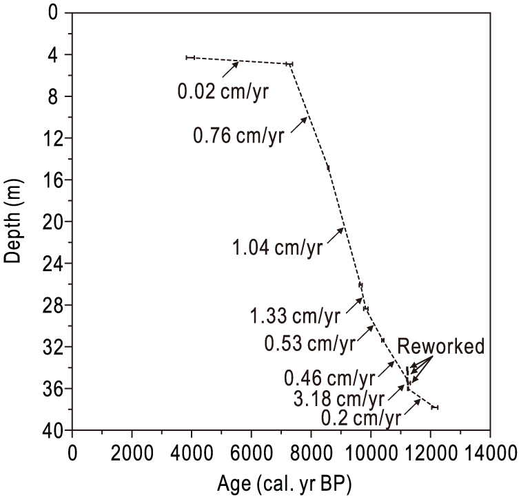
Age modelling and sedimentation rate.
Palynomorph spectrum
In this study, the palynomorphs included arboreal pollen (AP), non-arboreal pollen (NAP), FS and FA (Figure 5). The principal palynomorphs are included in the palynomorph diagrams. We divided the palynomorph spectrum into zones I–IV, based on CONISS analysis results (Grimm, 1991, 1992; Figure 5).
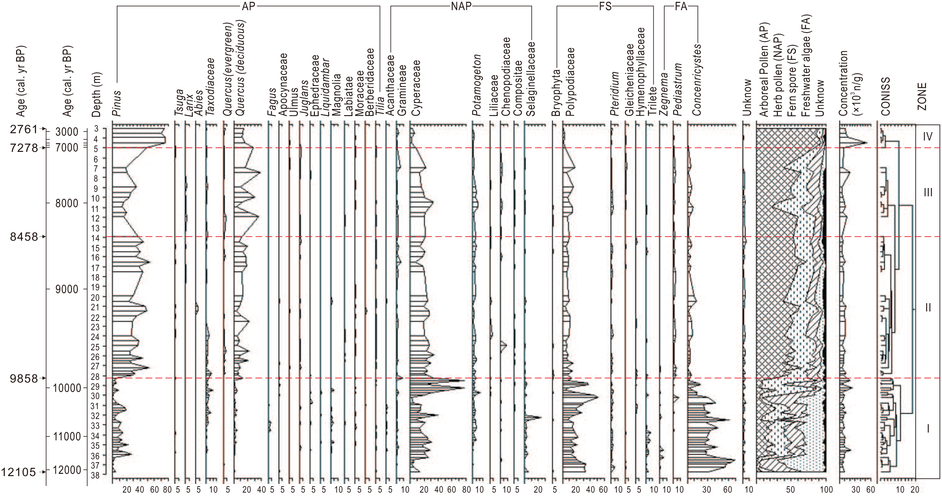
Palynomorph spectrum and zones from the GSL-13 core.
Palynomorph zone I (37.75–28.5 m, 12,106–9858 cal. yr BP)
In zone I, the proportions of AP, NAP, FS and FA were approximately 13.6%, 28.6%, 24.8% and 31.1%, respectively (Figure 5). Most of the AP was from Pinus, deciduous Quercus and Taxodiaceae, with average proportions of approximately 7.5%, 1.8% and 1.6%, respectively. The NAP was predominantly from Cyperaceae, Potamogeton and Selaginellaceae, with average proportions of approximately 22.2%, 2.3% and 2.1%, respectively. Most of the FS were from Polypodiaceae and Pteridium, with average proportions of approximately 20.1% and 1.3%, respectively. The major FA was Concentricystes, with an average proportion of approximately 30.2%. In this zone, the palynological concentration was approximately 1.0 × 10³ n/g.
Palynomorph zone II (28.5–13.95 m, 9858–8458 cal. yr BP)
In zone II, the proportions of AP, NAP, FS and FA were approximately 52.0%, 28.3%, 11.0% and 6.4%, respectively (Figure 5). Most of the AP was from Pinus, deciduous Quercus and Taxodiaceae, with average proportions of approximately 35.3%, 11.4%, and 1.5% respectively. The NAP was predominantly from Cyperaceae, Potamogeton and Gramineae, with average proportions of approximately 22.2%, 2.9% and 1.3%, respectively. Most of the FS were from Polypodiaceae, with an average proportion of approximately 8.1%. The major FA were Concentricystes and Pediastraceae, with average proportions of approximately 4.6% and 1.7%, respectively. In this zone, the palynological concentration was approximately 0.9 × 10³ n/g.
Palynomorph zone III (13.95–4.95 m, 8458–7278 cal. yr BP)
In zone III, the proportions of AP, NAP, FS and FA were approximately 46.5%, 29.5%, 15.7% and 6%, respectively (Figure 5). Most of the AP was from Pinus, deciduous Quercus and evergreen Quercus, with average proportions of approximately 21.1%, 21.3% and 1.2%, respectively. The NAP was predominantly from Cyperaceae, Potamogeton, Chenopodiaceae and Gramineae, with average proportions of approximately 21.6%, 3.9%, 1.4% and 1.3%, respectively. Most of the FS were from Polypodiaceae, Pteridium and Gleicheniaceae, with average proportions of approximately 11.4%, 1.5% and 1.4%, respectively. The major FA were Concentricystes and Pediastraceae, with average proportions of approximately 4.5% and 1.3%, respectively. In this zone, the palynological concentration was approximately 1 × 10³ n/g.
Palynomorph zone IV (4.95–3.0 m, 7278–2761 cal. yr BP)
In zone IV, the proportions of AP, NAP, FS, and FA were approximately 88.94%, 6.1%, 3.72%, and 0.7%, respectively (Figure 5). Most of the AP were from Pinus and deciduous Quercus, with average proportions of approximately 69.06% and 16.82%, respectively. The NAP was predominantly from Cyperaceae and Gramineae, with average proportions of approximately 3.76% and 1.2%, respectively. Most of the FS was from Polypodiaceae, with an average proportion of approximately 2.4%. FA was seldom present. In this zone, the palynological concentration was approximately 2.1 × 10³ n/g.
Discussion
Vegetation history of the eastern coast of the Yellow Sea
Several reports have described how the Holocene vegetation has changed on the eastern Yellow Sea coastal area in South Korea (Jang et al., 2006; Jun et al., 2010; Yi, 2011; Yi et al., 2005, 2012). However, there are regional differences because of variations in age resolution and sub-sedimentary environments. The pollen record from the Gunsan coastal area provides a relatively detailed history of the early- to mid-Holocene vegetation, especially from 12.1 to 7.3 cal. kyr BP. Fluctuations in the percentages of principal pollen types from the different zones indicate that the vegetation changed over the different periods (Figures 5 and 6).
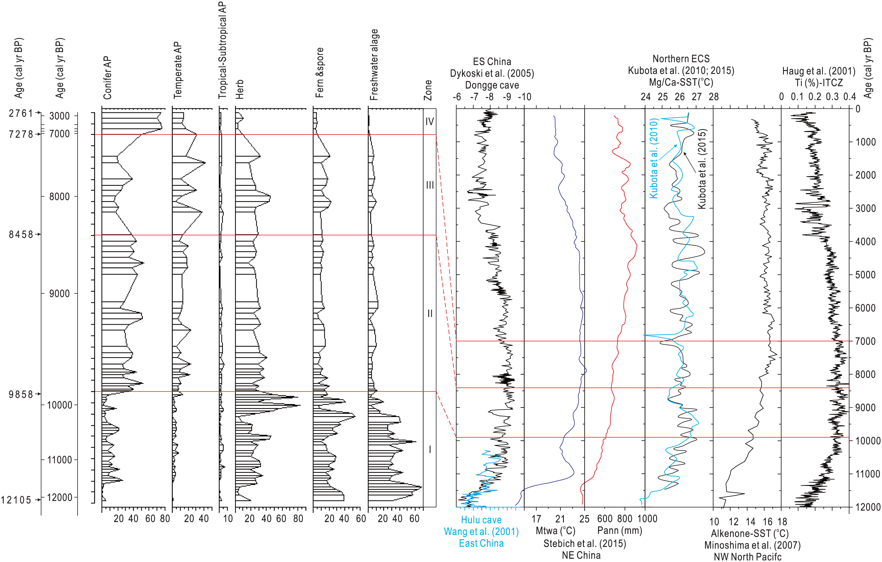
Pollen record and possible reasons for climate change.
During the period from 12,105 to 9823 cal. yr BP, the main vegetation included herbs and FS, with a few conifers and temperate broad-leaved trees. Many of the herbs were from the Cyperaceae, Potamogeton and Selaginellaceae. Many of the FS were from the Polypodiaceae and Pteridium. FA was also abundant. At this time, meadow vegetation predominated in a riverine wetland and there were a few trees from the Pinus and Quercus genera. The vegetation was similar to that reportedly present in other coastal areas, such as the coast of the northern Yellow Sea (Chen et al., 2014) and the Yangtze delta area (Qin et al., 2008).
During the period from 9823 to 8458 cal. yr BP, conifer AP and temperate broad-leaved AP increased in abundance, whereas FS and FA became less common. The proportion of conifer AP was much higher than that of temperate broad-leaved AP. Most of the conifer AP was from Pinus and most of the temperate broad-leaved AP was from deciduous Quercus. Perhaps the vegetation was temperate deciduous broad-leaved forest (Yi, 2011; Yim, 1977), similar to that present in this area between 7278 and 2761 cal. yr BP and similar to the modern vegetation found in the west-central Korean Peninsula (Yi et al., 2012). During the period from 8458 to 7278 cal. yr BP, the relative prevalence of Pinus and deciduous Quercus genera decreased and increased, respectively; this is consistent with findings reported by Jang et al. (2006). Human activity and secondary forestation have significantly affected the area from approximately 2000 cal. yr BP until the present time (Yi, 2011).
Climate change and climate dynamics
Holocene climate change on the eastern coast of the Yellow Sea
The pollen record from this area shows that the vegetation profile has fluctuated significantly over the period from 12,105 to 2761 cal. yr BP. Meadow vegetation in riverine wetland with a few Pinus and Quercus trees and an abundance of ferns and FA predominated from 12,105 to 9823 cal. yr BP, and the climate was cold and wet. In contrast, during the period from 9823 to 2761 cal. yr BP, the vegetation changed to temperate deciduous broad-leaved forests.
However, the vegetation did not remain unchanged throughout the period from 9823 to 2761 cal. yr BP. From 8458 until 7278 cal. yr BP, the records show that conifer AP decreased, and temperate broad-leaved AP increased in abundance. The climate was the warmest during this period, which is consistent with results from the stalagmite of the Daeya Cave in South Korea (Jo et al., 2011). The proportion of FS increased slightly from 8458 to 7278 cal. yr BP compared with 9823–8458 cal. yr BP. FS enrichment is more likely to occur as a result of flotation on water (Xu et al., 1996; Yang et al., 2016) than dispersal by wind (Beaudouin et al., 2007). Therefore, the slight increase in FS during this period suggests the climate was relatively wet.
In summary, changes in climate occurred over four different periods between 12,105 and 2761 cal. yr BP. The cold climate from 12,105 to 9823 cal. yr BP became warmer from 9823 to 8458 cal. yr BP. The climate was the warmest during the period from 8458 to 7278 cal. yr BP. The final change was to a relatively cold climate from 7278 to 2761 cal. yr BP. These general trends are consistent with those reported by Jang et al. (2006) and Yi (2011). The climate was relatively wet during the periods from 12,105 to 9823 and 8458 to 7278 cal. yr BP.
Possible reasons for climate change
The terrestrial Holocene climate recorded in ES/E and NE China demonstrated similar general trends (Dykoski et al., 2005; Stebich et al., 2015; Wang et al., 2001; Figure 6). There was a transition from a glacial to an interglacial climate in the early Holocene that was also observed in the Hanon Maar paleolake record from Jeju Island (Park and Park, 2015; Park et al., 2014). The marine climate deduced for the northern ECS (Kubota et al., 2010, 2015) and the northwestern (NW) North Pacific (Minoshima et al., 2007) also provides evidence for this transition. In this study, the pollen record highlights similar trends in climate change. However, the climate was relatively wet during the early Holocene in our study area, which is obviously different with the relatively dry climate recorded in NE China (Stebich et al., 2015).
Previous research suggests that monsoon precipitation and insolation-driven temperature changes co-determine the environmental dynamics in NE China (Stebich et al., 2015). It is also clear that strong and/or dry westerlies restricted the northward movement of the subtropical monsoon rainfall belt during the early Holocene (An et al., 2012; Stebich et al., 2015; Zhao and Yu, 2012). In this respect, our study findings are similar to those from NE China. The cold temperatures resulted from changes in insolation and the monsoon rainfall belt was restricted by the westerlies. In the early Holocene, northern and NE China were cold and dry and affected by strong and/or dry westerlies (e.g. Hulun Lake: Wen et al., 2010; Daihai Lake: Xu et al., 2010; Gonghai Lake: Chen et al., 2015; Bayanchagan Lake: Jiang et al., 2006; Sihailongwan: Stebich et al., 2015). The cooling of the Siberian air mass increased the pressure gradient between Siberia and the western Pacific in the winter, which intensified the westerlies. However, the strong winds blowing across the Yellow Sea may have increased the levels of precipitation on the east coast. Nakagawa et al. (2006) described a similar phenomenon. Some research links higher levels of rainfall with a rise in sea level during the early Holocene (Griffiths et al., 2009). At this time, the level of the Yellow Sea increased rapidly (Li et al., 2014; Liu et al., 2004), so higher rainfall on the east coast of the Yellow Sea may have resulted from the strong westerlies and rapid rises in sea level between 12.1 and 9.8 cal. kyr BP.
During the period from 9.8 to 7.3 cal. kyr BP, the climate warmed and it was particularly warm and wet between 8.5 and 7.3 cal. kyr BP. At this time, the climates of southeast China (Dykoski et al., 2005), NE China (Stebich et al., 2015), northern ECS (Kubota et al., 2010, 2015) and the NW North Pacific (Minoshima et al., 2007) were similar, and the Ti record shows that the Intertropical Convergence Zone (ITCZ) was at a relatively high latitude. The relatively warm temperatures found in areas affected by the EASM were produced mainly as a result of solar factors and the westerlies had a weak effect. The northward movement of the subtropical monsoon rainfall belt brought a warm and humid climate to these areas (An et al., 2012; Zhao and Yu, 2012).
Between 8.5 and 7.3 cal. kyr BP, there was a relative increase in sea surface temperature (SST) in the NW Pacific area (Minoshima et al., 2007). This may be one reason for the increased levels of precipitation during this period and could also be linked to La Niña–like activity. During La Niña–like activity, the SST in the NW Pacific is relatively high, and this intensifies the EASM, which brings more thermal energy and humid conditions to the coastal areas (Chen et al., 2015; Lim and Kim, 2007; Park et al., 2016; Wen et al., 2010). This association has been supported by recent climatology observations (Shen et al., 2011). The increased SST in the NW Pacific may result from increased SSTs in the western tropical Pacific. A corresponding westward shift in Kuroshio currents, higher temperatures and increased humidity could intensify the EASM effects during La Niña–like activity (Chen et al., 2015; Lim and Kim, 2007; Park et al., 2016; Wen et al., 2010).
During the period from 7.3 to 2.8 cal. kyr BP, the climate was relatively cold, which was reflected in the pollen spectrum. However, the sedimentary environment changed from lagoon to coastal sedimentary. The changing sedimentary environment can perhaps impact the pollen spectrum. However, when we compared with the other climate records in NE Asia, such as NE China (Jiang et al., 2006; Stebich et al., 2015), eastern Russia (Klimaschewski et al., 2015) and the (Korean Peninsula: Yi et al., 2011; Park et al., 2012), in addition, SST records are available from the northern ECS (Stebich et al., 2015) and NW North Pacific (Minoshima et al., 2007); we can find that different proxies, including pollen, stalagmites, Mg/Ca and alkenones from the EASM areas, show very similar climate characteristics. Therefore, the pollen spectrum likely reflected mainly the climate changes. However, there are very limited data in this study, and more high-resolution data on climate change during this period are required.
The ‘Younger Dryas’ event in NE Asia (NE China and South Korea)
The ‘Younger Dryas’ event has been reported in studies from different regions around the world, such as the Greenland ice cores from the North Atlantic (Rasmussen et al., 2006; Stuiver and Grootes, 2000); Lake Ammersee δ18O records from Germany (Von Grafenstein et al., 1999); Kulishu cave δ18O data from Beijing, China (Ma et al., 2012); Hanon Maar Lake pollen from Jeju Island, South Korea (Park et al., 2014); peatland pollen data from the Kamchatka Peninsula in Russia (Pendea et al., 2017); tree-rings from Bell Creek, US (Griggs et al., 2017); Padre Cave δ18O data from Brazil (Wang et al., 2007); sediment greyscale data from the Cariaco Basin in Venezuela (Hughen et al., 1996) and cave δ18O data from Hulu, Dongge and Yamen in China (Dykoski et al., 2005; Wang et al., 2001; Yang et al., 2010). Based on a high-resolution pollen analysis from Sihailongwan Maar Lake in NE China, Stebich et al. (2015) suggested that the climate during the ‘Younger Dryas’ event was relatively cold and dry. The pollen record indicated a similar climate in the Great Khingan Crater Lake in NE China (Wu et al., 2016).
During the period from 12.0 to 11.4 cal. kyr BP, the vegetation consisted mainly of FA, FS and herbs, with only a few trees (Figure 7). The FA, FS and herbs were from the Concentricystes, Polypodiaceae and Cyperaceae, respectively. There were also a few trees from the genus Pinus, but the lack of AP suggests the temperature was very cold at this time, although the abundance of FS and FA suggests high levels of precipitation, which is similar to the results obtained from Lake Suigetsu in Japan (Nakagawa et al., 2003, 2005, 2006). In addition, the SSTs recorded in the northern ECS (Kubota et al., 2010, 2015) and NW North Pacific (Minoshima et al., 2007) at this time were relatively low. Therefore, perhaps the low temperatures were mainly because of solar factors. This suggestion is supported by the Ti record the location of the ITCZ (Haug et al., 2001), in addition to the stalagmite analyses and monsoon records from Hulu Cave (Wang et al., 2001) and Dongge Cave (Dykoski et al., 2005).
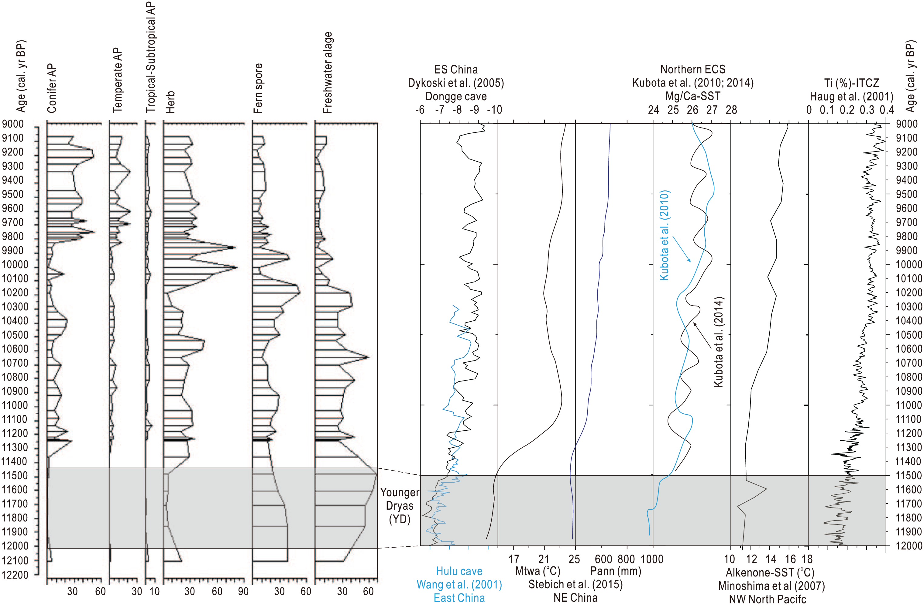
The ‘Younger Dryas’ event and its possible explanation.
In the monsoon area, precipitation and insolation-driven temperature changes co-determine the climate change dynamics (Stebich et al., 2015). However, during the ‘Younger Dryas’ event, the North Atlantic thermohaline circulation significantly reduced the temperatures in NE Asia (Nakagawa et al., 2003, 2005, 2006). The North Atlantic meltwater pulse reduced temperatures that were already low because of weak insolation. The cooling of the Siberian air mass caused an increase in the pressure gradient between Siberia and the western Pacific during the winter months (Nakagawa et al., 2006), and the strong winter monsoon intensified the westerly. This generated a cold, dry climate in NE Asia and brought higher levels of precipitation to Japan (Nakagawa et al., 2006). During this period, the climate was relatively wet on the eastern coast of the Yellow Sea, perhaps for similar reasons.
Conclusion
To understand the early- to mid-Holocene climate changes that occurred on the eastern coast of the Yellow Sea, we obtained a sedimentary core from the relatively stable environment near Gunsan on the east coast of South Korea. It was ideally suited for 14C dating by high-resolution AMS and palynological analysis.
The pollen record indicated that there were fluctuations in the vegetation profile in the area between 12.1 and 2.8 cal. kyr BP. During the period from 12.1 to 9.8 cal. kyr BP, there was predominantly riverine wetland meadow vegetation, with a few Pinus and Quercus trees and an abundance of FS and FA. During the period from 9.8 to 2.8 cal. kyr BP, the vegetation changed to temperate deciduous broad-leaved forest. During the period from 8.5 to 7.3 cal. kyr BP, the relative prevalence of Pinus and deciduous Quercus genera decreased and increased, respectively.
The cold climate from 12.1 to 9.8 cal. kyr BP became warmer during the period from 8.5 to 7.3 cal. kyr BP. This was followed by another relatively cold period from 7.3 to 2.8 cal. kyr BP. The changes in temperature may have been produced by solar factors, but the relatively humid periods from 12.1 to 9.8 and 8.5 to 7.3 cal. kyr BP arose for different reasons. The earlier humid period was produced by strong westerlies and rapidly rising sea levels. The later humid period was produced mainly by the strong EASM and may also be linked to La Niña–like activity.
The ‘Younger Dryas’ event was observed in this study but was relatively cold and wet. The low temperatures may have been produced by a North Atlantic meltwater pulse. This would have reduced temperatures that were already low because of weak insolation, and the strong winter monsoons would have increased the levels of precipitation.
Footnotes
Acknowledgements
The authors greatly appreciate the assistance from two anonymous reviewers for their comments and suggestions, which improved the manuscript.
Funding
This study was supported as a basic research project (GP2017-013) by the Korean Institute of Geoscience and Mineral Resources (KIGAM) and the Chinese Natural Science Foundation (nos 41271205 and 41506103).
