



Abstract
The Udu-dong archeological site in Chuncheon, South Korea, dates back to the Proto–Three Kingdoms Period (approximately 100 BC to AD 350). Many artifacts, including some earthenware, have been excavated in these ancient dwelling sites. We applied three geochronological dating methods (radiocarbon, optically stimulated luminescence (OSL), and archeomagnetic dating) to the archeological remains of this large-scale human settlement and reconstructed the history of depositional processes prior to human settlement. The timing of the ancient community’s settlement was investigated by radiocarbon dating of the charcoal fragments collected from old furnaces. Archeomagnetic dating allowed us to constrain the time period of the settlement’s abandonment by dating the last use of fire. The timing and development of fluvial deposits underlying the settlement site were reconstructed by OSL dating combined with sedimentary facies analysis. Our results show that, following the deposition of coarse sediments starting 10,000 years ago, the region formed a stable floodplain environment starting around 3000 years ago; people began to form clustered settlements approximately 50 years later. For the subsequent 150 years or so, the area was heavily used as a settlement site, with people evenly distributed across it, before eventual abandonment of the site around AD 200–250. Because the sedimentary deposits do not show any significant facies change during this period, we conclude that any catastrophic events were not the main reason for settlement abandonment. This study suggests that combining scientific and archeological analyses have significant benefits for studies of such archeological sites. Therefore, continuous collection of such data can provide important information for the excavation and protection of prehistoric or historic sites.
Keywords
Introduction
Archeological remains of the period from the Bronze Age to the early Iron Age in Korea (approximately 15th century BC to 4th century AD) are randomly distributed across the Korean Peninsula; many are found along the river banks of big rivers. The Udu-dong archeological site in Chuncheon, northern central South Korea, is located at the junction of the Bukhan and Soyang Rivers; approximately 227 ancient dwelling sites and artifacts from the Bronze Age to the Proto–Three Kingdoms Period (early Iron Age) have been discovered with ironmongery.
In Korean archeology, the Proto–Three Kingdoms Period precedes the Three Kingdoms Period, connecting prehistoric times to historical periods (Jung, 2015). This period lasted from approximately 100 BC to AD 300 (Park, 2004). Historical records from this time are scarce, but archeological records are plenty. People in those days lived in ‘呂-shaped (and 凸-shaped)’ dwelling sites and generally used hard, plain pottery, which was baked at higher temperatures (about 800–900°C) than was previous pottery. The culture of this time had clear characteristics – the extinction of bronze artifacts, the invention and distribution of ironware, the development of farming with cows, and so on. Archeological studies on the Proto–Three Kingdoms Period have mainly focused on architectural characteristics within dwelling sites, the chronology and transition of excavated artifacts, and the characteristics of artifacts from each region in the specific period (Kim, 2008). Although radiocarbon dating has frequently been performed on charcoal samples from the archeological sites, these dates are not believed to play an important role in the comprehensive interpretation of archeological remains (Lee, 2008; Park, 2015).
Through this study, the sedimentary environments have been investigated for the sites from the Proto–Three Kingdoms Period, and the timing of human activities and their disappearance at the Udu-dong archeological site have been elucidated by age dating. The sedimentary environment at the archeological site involved activity and extinction. For example, the floodplain environment at the site was a supportive living environment, but a great flood resulted in its extinction. Therefore, the sedimentary environment was very closely related to the formation of the archeological site. We analyzed the sedimentary profile at the Udu-dong archeological site and performed optically stimulated luminescence (OSL) dating to interpret the timeline and evolution of the depositional setting and sedimentation. Given that human settlement probably began after the stabilization of the depositional conditions, radiocarbon dating was also carried out to identify the timing of the most dynamic human activity. Finally, we applied the archeomagnetic dating technique to the furnace sites within the collective village to independently infer the timing of the last human activities. As far as we know, such diverse dating analyses have not been conducted on a single archeological site. Therefore, it is expected that this integrated study can provide new information on the interpretation of archeological sites.
Characteristics and meaning of the Udu-dong archeological site
Udu-dong remains are located on fluvial land where the Bukhan River and the Soyang River meet. The investigated area includes about 400,000 m2. The results of the excavation showed a total of 858 units of remains, which included 48 units of trap from the Bronze Age, 228 dwelling sites, 159 chickees, 345 pits, 31 burned traces, 28 ditches, 1 wooden well, 1 tract of arable land, and 3 tombs of the Proto–Three Kingdoms Period of Korea, and 1 street and 13 tombs of the Joseon dynasty. According to those archeological remains, this Udu-dong site was mostly occupied during the Proto–Three Kingdoms Period of Korea.
The dwelling sites of the Proto–Three Kingdoms Period are mostly ‘呂-shaped (and 凸-shaped)’. Inside the dwelling house, hard, plain pottery, embossed pottery, Lorang-style earthenware, spinning wheels, ironware, stone tools, and burned cereals were unearthed.
The wooden well is a very interesting and important thing. It is located on the border of an old ditch across the middle of a village. This is the oldest well in the Proto–Three Kingdoms Period and appears to be the most predated remains in the site; it may have been constructed as a foundational part of the village’s infrastructure development. The arable land areas ranged approximately 340 m from east to west and were used as dry fields. This land corresponds to a relatively early stage at the site. It is also the oldest and largest case of arable land from the Proto–Three Kingdoms Period to the Three Kingdoms Period of Korea excavated in the central district of the Korean Peninsula.
Iron drags, brass pots, earthenware fragments in which the iron slags were attached, damaged ironware, and a small cylindrical blast pipe were unearthed from a dwelling site. Within the vicinity, a charcoal layer was deposited 10–20 cm high, and burned traces considered to be smithy hearth were heavily distributed. These were by-products of outdoor heat-hardening and evidence of ironware manufacturing activity in the village.
Flowerpots, which were Lorang style, and bronze rings were unearthed from wooden coffin tombs of the Proto–Three Kingdoms Period. They are appraised as significant artifacts in the central district where the tombs of the Proto–Three Kingdoms Period were rare.
Radiocarbon dating and chronological records provide further insight into the evolution of hard plain pottery and Lorang-style jars with flat bottoms. That is, Udu-dong remains appear to have been occupied from the 1st to 3rd century AD. Udu-dong remains can be inferred as those of a base village of the Proto–Three Kingdoms Period where life, labors, manufacturing activity, and death existed organically.
Study area and methods
The study area in the central Korean Peninsula is located in the oval-shaped Chuncheon Basin that is elongated in the north-south direction, in which the southward-flowing Bukhan River meets the southeastward-flowing Soyang River (Figure 1). The Chuncheon Basin is surrounded by high mountains consisting of Precambrian metamorphic rocks, while the basin (the Udu Plain) is underlain by Mesozoic granites (Lee et al., 1974). This basin is thought to have been formed by differential weathering of granite. The landscape of the basin is strongly influenced by the rivers flowing through the basin, and much of the land is now used for rice cultivation. Archeological finds in this region range widely from dwelling ruins to burial remains (Shin et al., 2014). Many artifacts are distributed in alluvial sediments near the Bukhan and Soyang Rivers, indicating that ancient settlements were located along both rivers. The Udu-dong archeological site may have been preserved by occasionally flooded sediments that covered the ruins. The Udu-dong site emphasized in this study was an ancient floodplain environment, although the site was not near the current river channels.

3D geomorphic location map of the study area in Chuncheon, Korea.
We used three dating methods in this study. Radiocarbon dating is commonly performed on carbonized wood samples to estimate their ages. At the Udu-dong site, we applied this method to 42 charcoal samples collected from the dwelling sites, using an accelerator mass spectrometer (AMS, High Voltage Engineering Europa) housed in the Korea Institute of Geoscience and Mineral Resources (KIGAM).
The archeomagnetic dating method generally uses the direction of remanent magnetization recorded in a heated archeological sample (Figure 2). Comparison of this direction with the secular variation data allows for estimation of the sample’s age. Archeomagnetic samples were collected from soils of horizontal furnace surfaces in dwelling sites, using non-magnetic cubic boxes (2 × 2 × 2 cm3), and oriented with a Brunton compass. A total of 255 samples were obtained from 17 dwelling sites (Figure 3). In the laboratory, we filled empty spaces within the sample boxes with plaster of Paris to avoid disturbing the samples during the experiments. All samples were stored in a Mu Metal shield assembly to prevent them from acquiring viscous remanent magnetization (VRM), which can be caused by the external magnetic field.

Examples of archeomagnetic samples from the Udu Relics site: (a, b) panoramic views of the dwelling sites of No. 108 and No. 146, and close-up views of furnace sites boxed in (a) and (b).
The natural remanent magnetization (NRM) of the samples was measured using a Molspin spinner magnetometer, and the samples were subsequently demagnetized by stepwise alternating field (AF) demagnetization using a Molspin AF demagnetizer. The AF demagnetization was performed at a field strength of 5–30 mT with 5 mT intervals and 40–90 mT with 10–15 mT intervals. Then, the archeomagnetic data from all samples were projected onto an orthogonal vector diagram (Zijderveld, 1967), and the characteristic remanent magnetization (ChRM) direction of each sample was determined using principal components analysis (PCA) with the anchored line fit method (Kirschvink, 1980) from at least three or more points.
OSL dating is now widely accepted as a robust tool for dating Quaternary sediments. Thus, in this study, we applied the OSL dating method to the sediment samples, which consist of sands with occasional gravel clasts and very little organic matter or charcoal. We collected samples using 30-cm-long light-tight steel pipes. The sample preparation, OSL signal, and dose rate measurements were carried out using facilities installed at the Ochang Center of Korea Basic Science Institute (KBSI). In the subdued darkroom, the sediment samples were first wet-sieved to recover the size fractions of 90–250 µm. Then, pure quartz extracts were obtained using a routine sample preparation procedure involving 10% HCl, 10% H2O2, concentrated hydrofluoric acid, and density separation. The OSL signals were measured using a standard Risø reader (Model TL/OSL-DA-20C/D), which is equipped with a 90Sr/90Y beta source, delivering 0.087 ± 0.01 Gy/s to the sample position. Blue light emitting diodes (470 nm, full width at half maximum [FWHM] = 20 nm) were used for optical stimulation, and the OSL signal detection was through 7-mm Hoya U-340 optical filters. The equivalent dose (De) values were estimated using the single-aliquot regenerative-dose (SAR; Murray and Wintle, 2000) protocol. For De estimation, twelve 8-mm aliquots consisting of several thousands of coarse quartz grains (~2000–3000 grains) were used; this sort of OSL dating is sometimes referred to as single-aliquot multiple grain dating. For dose rate estimation, the radionuclide concentrations of the samples were measured using a low-level, high-resolution gamma spectrometer, and the conversion to dose rates used the data presented by Olley et al. (1996). Cosmic ray contributions were estimated using the method given by Prescott and Hutton (1994).
Interpretation of geochronological data
Radiocarbon dating
The radiocarbon ages obtained from the dwelling houses were converted into calendar years using the Calib 7.0 program (Table 1). We determined the absolute age range using the highly reliable two-sigma (95.4%) values. Ages for these sites range from the oldest, 70–90 BC at sites 24 and 88, to the youngest, AD 270–330 and AD 280–330 at sites 93(1) and 209(1), respectively; most sites have ages between cal AD 50–200 (Table 1, Figure 4). According to the results of the archeological excavation, we infer that the human occupation was very dynamic during this period. In order to explain the wide age range, we suspect that older ages probably reflect the reworked charcoal fragments from outside the sites and that younger ages may reflect contamination of the samples by younger carbon. Overall, given the generally even distribution of ages shown in Figure 3, we infer that most of the samples were effectively dated and reliable (Figure 4). Such a finding seems to be caused by the ages of the locations of dwelling sites 93 and 209. In general, the activities in the ruins were intensively concentrated in the ages of AD 50–200 (Figure 4).
Radiocarbon dating results of the study area.

Dates are given in AD unless otherwise noted.
Calibrated 14C dates as cal BP or cal AD.
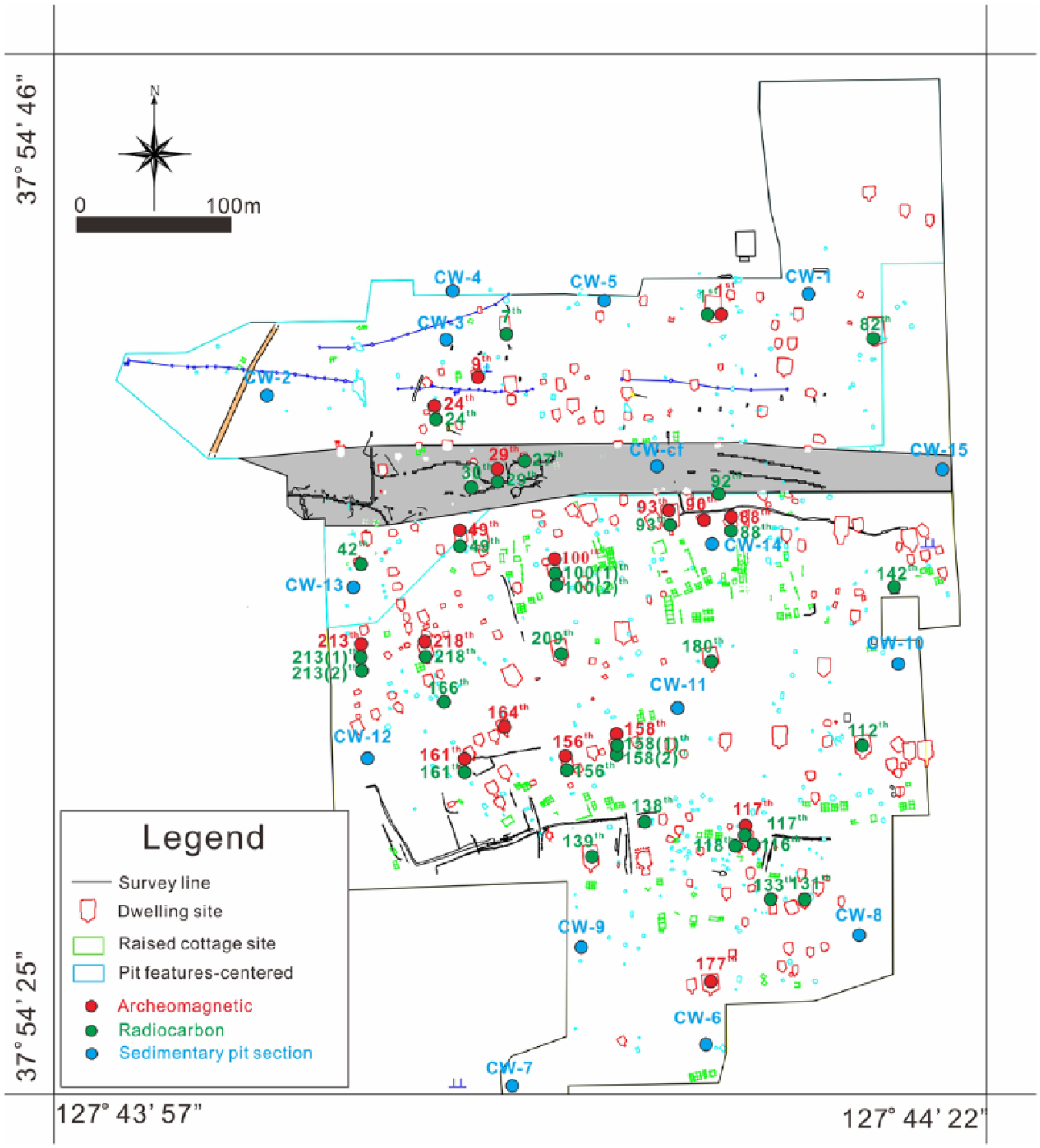
Locations of samples for age dating (radiocarbon and archeomagnetic) and sedimentary sections of study area.

Radiocarbon dating results for the study area.
Archeomagnetic dating
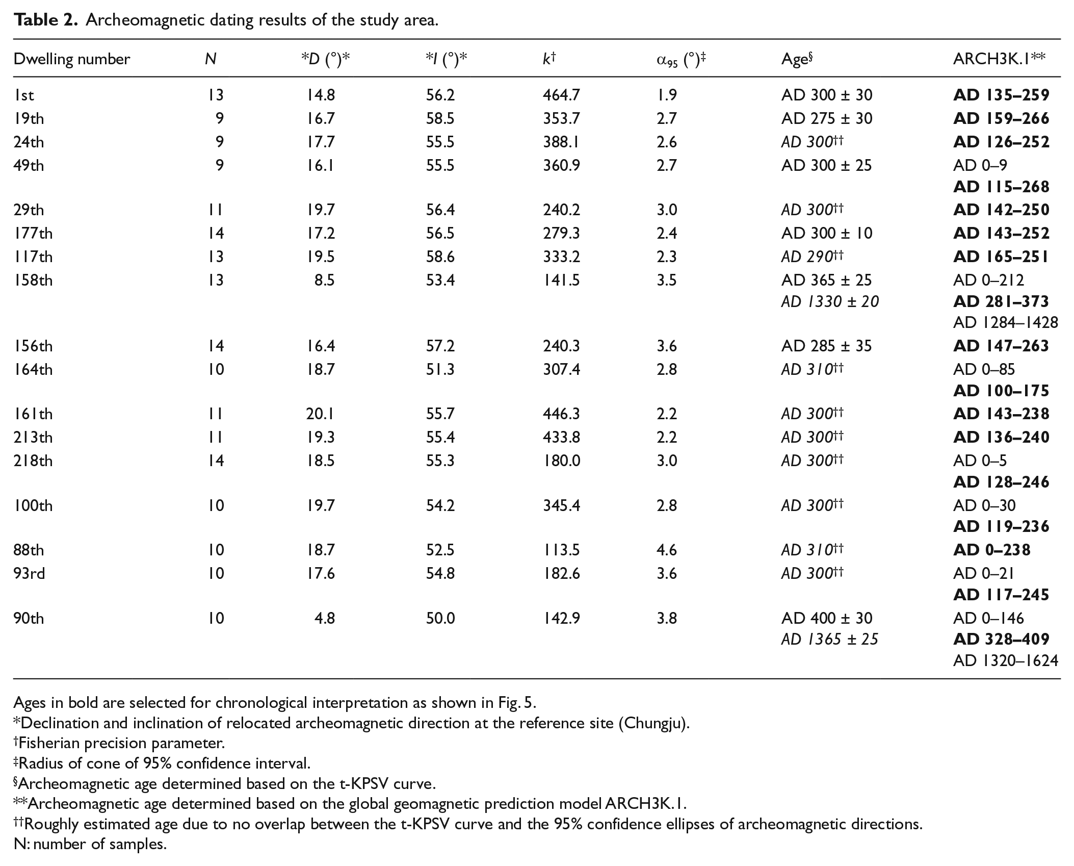
The stepwise demagnetization of most samples shows simple decay of a northerly and moderately downward component. Some samples reveal two components of remanence. After removal of a low coercive component at demagnetization steps below 5–15 mT, the characteristic component of northerly declination and moderate inclination is isolated in the 20–50 mT range. The low coercive component can be interpreted as a VRM, because the samples could not acquire chemical remanent magnetization (CRM) or thermoviscous remanent magnetization (TVRM) under the conditions of shallow depth and a geologically short period of burial of the archeological remains. The ChRM component could not be isolated from the 64 samples showing unstable demagnetization behavior. The 17 site-mean directions and their statistical parameters were calculated from the ChRM directions of 191 samples, using Fisher statistics for the dating (Table 2 and Figure 5).
Archeomagnetic dating results of the study area.
Ages in bold are selected for chronological interpretation as shown in Fig. 5.
Declination and inclination of relocated archeomagnetic direction at the reference site (Chungju).
Fisherian precision parameter.
Radius of cone of 95% confidence interval.
Archeomagnetic age determined based on the t-KPSV curve.
Archeomagnetic age determined based on the global geomagnetic prediction model ARCH3K.1.
Roughly estimated age due to no overlap between the t-KPSV curve and the 95% confidence ellipses of archeomagnetic directions.
N: number of samples.
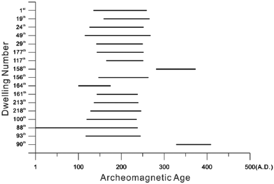
Archeomagnetic dating results for the study area.
Paleosecular variation data during the past 2000 years from the Kyoto region in southwestern Japan (Hirooka, 1971) were recalculated for the Chungju region (37°N, 128°E) of the Korean Peninsula using the direction-pole-direction method for the archeomagnetic dating in this study, which refers to a tentative Korean paleosecular variation (t-KPSV) curve (Lee et al., 2001). Archeomagnetic ages were determined from the median values of the segments of the t-KPSV curve overlapped by the 95% confidence ellipses of the archeomagnetic directions. Eight out of 17 dwelling sites have been dated using this method. Two of them (90 and 158) showed two different age periods (Table 2), because the Earth’s magnetic field had very similar directions in AD 300–400 and AD 1300–1400. This ambiguity of dating can be resolved by contextual interpretation with archeological constraints and other dating method results. For the remaining nine dwelling sites with no overlap between the t-KPSV curve and the 95% confidence ellipses of archeomagnetic directions, the archeomagnetic ages were roughly estimated by the least distance from the directions to the t-KPSV curve (Table 2). Archeomagnetic ages of all the sites are interpreted as highly reliable based on the very narrow interval of ages (approximately AD 245–430), high-precision parameter (k ≥ 113.5), and low 95% confidence circle (α95 ≤ 4.6). Samples recorded stable thermoremanant magnetizations. Seventeen sites had ages between AD 245 and AD 430, especially concentrated around AD 300. Therefore, we have confidence in the accuracy of the archeomagnetic data.
However, the t-KPSV curve has two considerable problems, because only Japanese archeomagnetic data were used, and the effect of a non-dipole field between the two regions could not be reflected in the conversion to the t-KPSV curve. Park and Park (2014) recently reported huge relative differences in archeomagnetic directions for the t-KPSV section including approximately AD 0–300, particularly in declinations. Therefore, to improve the conventional t-KPSV-based approach, we employed the ‘Matlab tool for Archeomagnetic Dating’ program (Pavón-Carrasco et al., 2011) to perform additional dating, applying the ARCH3K.1 global geomagnetic prediction model (Table 2). Most of the resulting dates were earlier than the t-KPSV ages. After considering the radiocarbon dating results, we concluded that these results have higher reliability. Although most sites were of similar age, it is noteworthy that site 90 revealed a date about 100 years younger than the other sites, suggesting that, relative to the other sites, it was utilized last.
OSL dating
We OSL dated 20 sediment samples from six sediment trenches (Figure 6; CW-Levee, 2, 6, 9, 10, 13; Table 3). As these results are combined with the sedimentary analysis of each pit, the OSL results are discussed in more detail in the ‘Interpretation of geochronological data’ section. In general, our OSL ages seem to indicate that most sediments above the trough cross-bedded gravel facies (Gt facies; for more detail, see ‘Interpretation of geochronological data’ section) began to form around 8–9 ka, while the OSL ages of the samples from the westernmost pit, CW-2, indicate slightly earlier commencement of the sedimentation (~11–14 ka).

Sedimentary columnar sections describing sedimentary facies at the Udu-dong archeological site, Chuncheon, Korea.
OSL dating results of the study area.

OSL: optically stimulated luminescence; SE: standard error.
Discussion of dating results
In this study, 17 sites were dated using the archeomagnetic method, 42 sites were dated using the radiocarbon method, and 20 sites were dated using the OSL method (Figure 3). Few studies have performed such a variety of dating methods at a single archeological site. The archeomagnetic dating results indicate the time at which furnaces were disappearing from the dwelling sites (Figure 5). Carbon dating results indicate the time period of the main period of human occupation. If any wood used for charcoal was originally older than the age of human activity, the ages obtained from the charcoal would be older than the actual occupation time. Finally, OSL dating results indicate the depositional age of sediments before the human settlement in this area. Based on these diverse dating results, the following scenario can be proposed. In the study area, sandy sedimentary layers began to accumulate from 10,000 to 5000 years ago. It is difficult to determine the initial period of human occupation after the stabilization of sediments, but the most active dwelling period in this site can be estimated at AD 50–200 based on the radiocarbon dating results. Finally, this dwelling site was abandoned around AD 150–250; some time overlap between stages occurs because of the errors in the dating range. Consequently, we conclude that human occupation at the Udu-dong archeological site rose and fell between about AD 50 and AD 200, a relatively short period. Also, no thick sand layers covering the sites were found, which suggests that the sites have not been abandoned by any natural catastrophic events.
Sedimentary environmental analysis
In order to analyze the sedimentary environment, we produced columnar sections for a total of 16 sedimentary profiles based on general depositional characteristics. In addition to the columnar sections, particle size analysis was carried out in order to more precisely identify the sedimentary layers. Size analysis was focused on the sections with distinguishable layers or the sections showing facies changes for facies interpenetration. Finally, the depositional age was estimated based on the OSL dating results.
Sedimentary facies analysis
Gt facies: Trough cross-bedded gravel facies
These facies consist of rounded gravels, mostly occurring near the lowermost part of the sections. Gravel size is diverse, from granule to boulder, with various lithologies, including gneiss, granite, quartzite, and felsite (Figure 7a). Trough cross-bedding is also observed, sometimes with a single small channel shape. This unit represents a gravel bar in a braided stream, in which trough cross-bedding is accumulated in overlapping gravel beds within the channel. This unit occurs at different levels in each sedimentary profile.
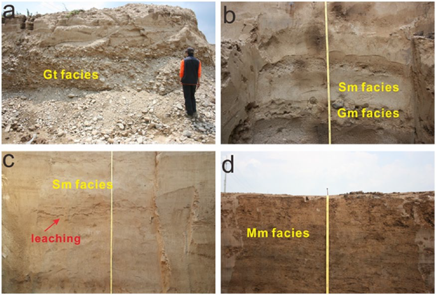
Trenched sedimentary sections showing facies characteristics in the Udu-dong area, Chuncheon, Korea. The section shows mostly sandy and muddy layers with some gravel layers: (a) a rounded site, (b) CW-2, (c) CW-6, and (d) CW-11.
Gm facies: Massive gravel facies
These facies occur above the Gt facies, including in the sand layers (Figure 7b). They are similar to the Gt facies but with smaller particle sizes. Gravel layers are relatively thin: 10–20 cm thick. This unit represents flood deposits over underlying sandy gravel sediments.
Sm facies: Massive sand facies
These facies overlay the Gt facies and are observed in all sedimentary sections (Figure 7c). It is a generally thick, massive sandy layer with varying grain sizes, from fine sand to granule. Faint laminations can be observed in some sections. In places, thin layers of gravel or muddy sand are found within the facies. Although most of the sedimentary profiles clearly show a fining-upward sequence, coarse sands occur in some sections. Amalgamation can be found where muddy layers overlay the sand, suggesting that these layers occasionally penetrated into the sandy layer along the flow of surface water or groundwater. The sandy deposits were deposited in a braided river channel. We suggest that the fining-upward sequence in this unit reflects a channel migration further from the early depocenter.
Ms facies: Sandy mud facies
These facies are intercalated in the Sm facies and consist mainly of sandy mud or muddy sand deposits. These layers tend to be thicker up-section. Ms facies would have been partially eroded with coarse sand in the upper part. Within these muddy layers, mottling marks imply that coarse sands were deposited over these layers after post-depositional vegetation growth. Mottling marks occurred where vegetation developed.
Mm facies: Massive mud facies
These facies occur at the top of most sections and consist of massive sandy mud with no sedimentary structures (Figure 7d). Traces of vegetation are commonly found and sands are distributed in a lenticular shape. Modern plant roots are also observed. These facies are interpreted as floodplain deposits formed by lateral channel migration.
Mo facies: Organic rich mud facies
These muddy facies contain a large amount of organic matter. It is observed only in the CW-Levee section (Figure 6). Lateral migration of a meandering channel gave rise to an abandonment of the channel and resulted in an oxbow lake. This small lake was changed into a swamp and then infilled with organic-rich mud sediments under low-energy conditions. Therefore, these facies are interpreted as swamp deposits formed after channel abandonment.
Sedimentary environmental analysis
Since the current study area is far away from the Bukhan River, the sediment supply from this river is relatively limited. Occasional depositions of muddy sediments occur by flooding of nearby small streams, and small channels that originate from the mountains also supply small amounts of sediments. In the past, however, the Bukhan River was closer to the site than it is today, allowing deposition of gravel and sands. The study area was not affected by the Soyang River, as it was blocked by hills in the east. Based on the characteristics of sediments and dating results, paleoenvironments of the study area can be deduced as follows (Figure 8).
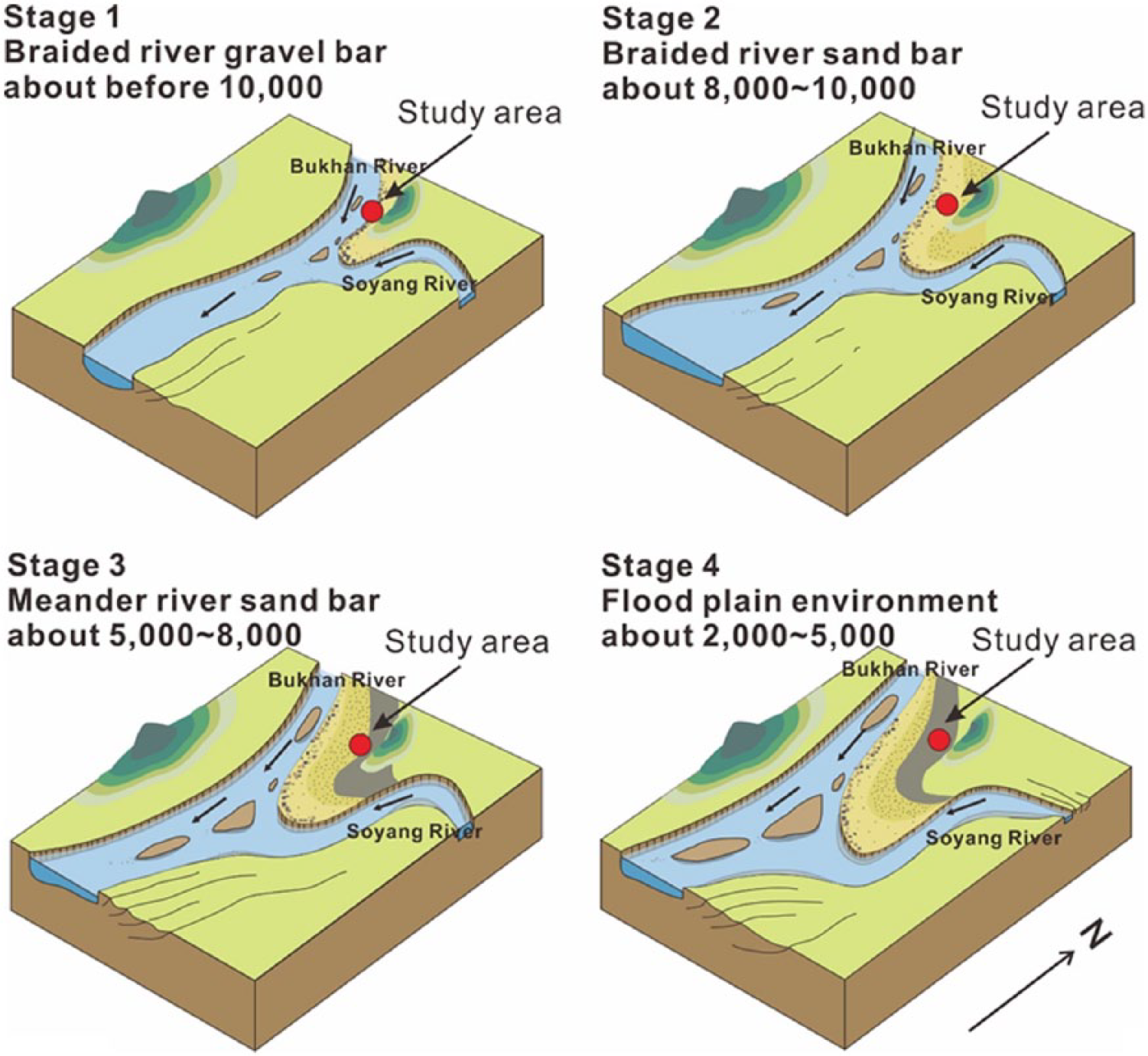
Reconstructed evolutionary history of the sedimentary environments of the Udu-dong area, Chuncheon, Korea.
Braided river with gravel bars
Well-rounded gravel and trough cross-beddings are commonly found in this bottom layer. The Gt layers are thickest in the northern part of the study area, becoming thinner toward the south. In profiles CW-10, 11, and 13, these deposits are found especially in the deeper parts, suggesting a strong possibility of the existence of a wide channel. We can infer that these gravel bars were formed by the braided Bukhan River channel. In the early stages, the deposition of gravel layers started in the northern part, then moved south by lateral channel migration. The OSL results indicate that these gravel layers were formed approximately 10,000 years ago.
Braided and meandering river with sand bars
Sand bar layers consist of fine sands to granules and have poor lateral continuity. As the Bukhan River channel moved south toward its present location, sandy sediments were continuously deposited above the gravel bar sediments. Between the sand bars, muddy deposits were piled up again but were eroded out soon. Through this process, most of the region was covered with sand layers, most likely supplied from the Bukhan River with very little contribution from the Soyang River. We estimate that this sedimentation took place from approximately 10,000 to 5000 years ago, during which the river seems to have migrated continuously. The sand layer is also supposed to have been deposited from north to south, and the sands were largely transported by the Bukhan River.
Floodplain environment
Finally, a floodplain environment developed, depositing muddy layers after inhabitation at the site. The continued migration of the Bukhan River channel away from the site changed the sedimentary environment, allowing mud deposition in the floodplain environment. We suggest that the region had a low rate of deposition, active vegetation growth, and a relatively stable environment before the establishment of the dwelling sites. These sites were abandoned after the dynamic human activities from AD 50 to AD 250 during the Proto–Three Kingdoms Period. We presume that the sites were not finally abandoned because of any catastrophic sedimentary events, but possibly due to a special historic event. It is supported by the relatively thin sedimentary layer covering the relics at the site and the layer immediately atop the site is not much more coarsely grained than those below it. Moreover, since the floodplain environment has been continuously maintained since that period, the region seems to maintain a stable environment longer than other regions (Figure 9).
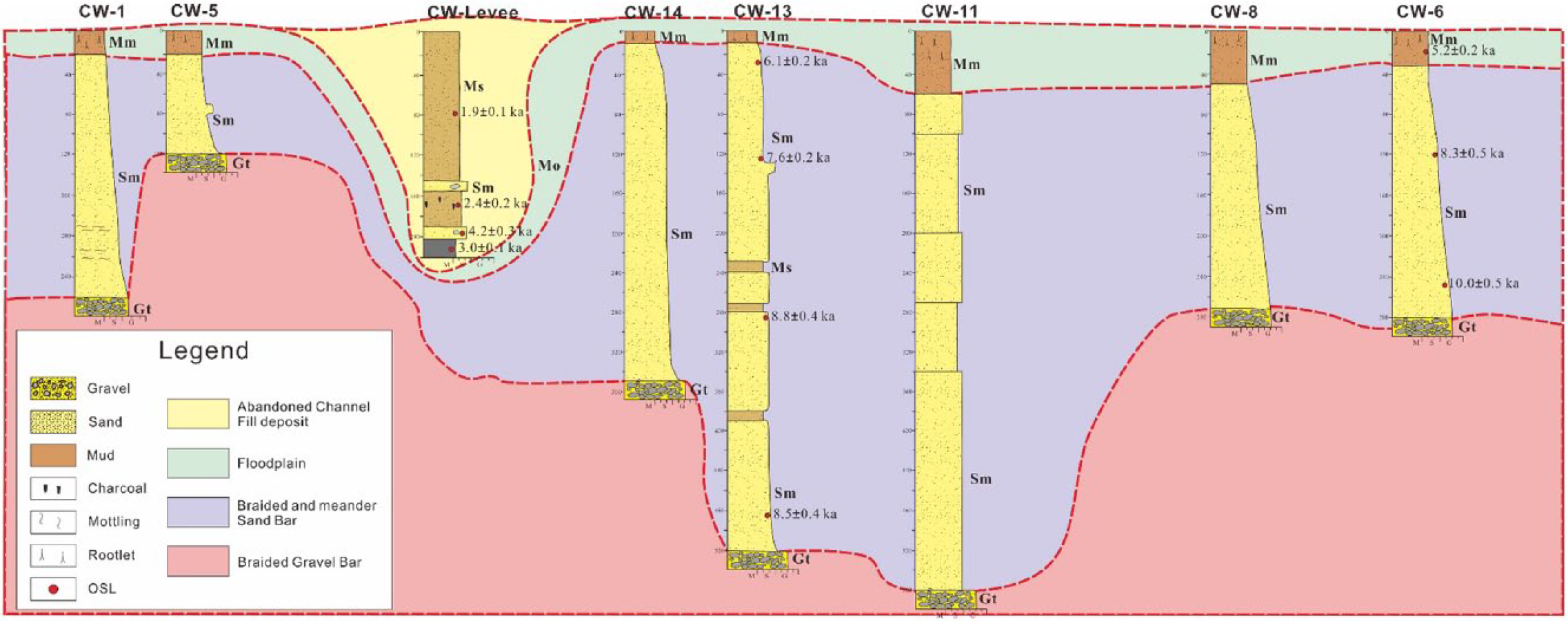
Sedimentary columnar section divided sedimentary environment change in Udu-dong Chuncheon.
In late stages, a floodplain environment was maintained by continuous lateral migration of the Bukhan River. During this period, relatively fine sediments were deposited in the floodplain with a very low sedimentation rate; then, the stable sedimentary environment was maintained with active vegetation. The stabilization of this area was accompanied by human settlement. This area was abandoned after the dynamic human activities from AD 50 to AD 250 during the Proto–Three Kingdoms Period.
Conclusion
The Udu-dong archeological site in Chuncheon, South Korea, is located in the Udu Plain where the Bukhan and Soyang Rivers are confluent. Abundant dwelling sites and artifacts from the Proto–Three Kingdoms Period have been discovered here. We undertook sedimentological and chronological investigations to identify the timing of human inhabitation and abandonment of this area. Sedimentary records show that the environment of the area started as a braided channel with gravel bars around 10,000 years ago, gradually changing to a sandy channel before stabilizing as a floodplain environment due to the continued southward migration of the Bukhan River channel. This floodplain environment was very stable, experiencing rare overflows with only inflows of small streams from the nearby mountains.
Our carbon dating results indicate that large communities lived here during the Proto–Three Kingdoms Period from around AD 20 to AD 200. The site’s abandonment was archeomagnetically dated to be around AD 150–200, approximately 50 years later than the radiocarbon dating result. Based on the radiocarbon and archeomagnetic dating results, we found that the Udu-dong archeological site does not have any serious age differences. Diverse chronological approaches can be applied to regions with a single dwelling area to determine its prosperity and extinction timing scientifically. In addition, our sedimentary environmental analysis allowed for further understanding of the sites’ natural settings at the beginning and abandonment of dwellings. We conclude that the combined geological and archeological analyses have significant benefits for the interpretation of an archeological site, and the scientific database of the archeological remains should be established by further collaboration between geologists and archeologists.
Footnotes
Funding
This research has been supported by the research project from the Hangang Institute of Cultural Heritage and by the 2016 Research Grant to Daekyo Cheong from Kangwon National University (D1000705-01-01).