



Abstract
The ancient lake Duvensee in Schleswig-Holstein, Germany, is one of the prime locations in northern Europe for early Holocene research. Archaeological sites on the former lakeshore provide vivid illustrations of early Mesolithic life, with bark mats and other organic finds preserved, including evidence for the extensive use of hazelnuts. Although the area has been the subject of research for almost 100 years, a coherent summary of these discoveries has not yet been written. Here we review past research at Duvensee, and give some prospects for further research. We show that the Duvensee sites varied in their structure and chronology. While only a limited number of sites can be connected to hazelnut exploitation, some of them show signs of hafting and retooling and other domestic activities. At a few sites, specific hearths were excavated which can be connected with hazelnut roasting and other subsistence activities. Finally, we show that while most earlier studies focused almost exclusively on archaeological research questions, Duvensee has the potential to reveal not only transformations in human behaviour, but also environmental changes at a detailed scale; we therefore argue for a more holistic perspective and multidisciplinary approach to reconstructing prehistoric landscapes and cultural transformations.
Keywords
Introduction
Few archaeological sites provide preservation conditions that allow settlement structures and camp organization of hunter-gatherers to be analysed in great detail. For the Mesolithic, only a handful of such sites are known and even fewer permit the study of developments and social transformation over time. In this paper, we review archaeological research at the Duvensee peat bog in south-eastern Schleswig-Holstein, Germany, which is one of the best-preserved Mesolithic site complexes on the North European Plain. After almost a century of research (Figure 1), the features and finds provide deep insights into the world of Mesolithic people and their activities in and around an ancient lake.

Overview of the year of excavation of the different sites in Duvensee and the responsible researcher.
A total of 23 Stone Age sites have been recorded in the 4.3 km² large bog, of which 17 have been (partly) excavated (Figure 2). While the occupation of individual campsites was relatively brief, the full extent of Mesolithic occupation at Duvensee spans several millennia, and encompasses notable landscape transformations. Palynological and radiocarbon dating sets the establishment of the first known Mesolithic camps within the Preboreal, whereas the youngest Mesolithic occupation is dated to the early Atlantic. Further occupations are proven for the early Funnelbeaker and for the Single Grave culture.
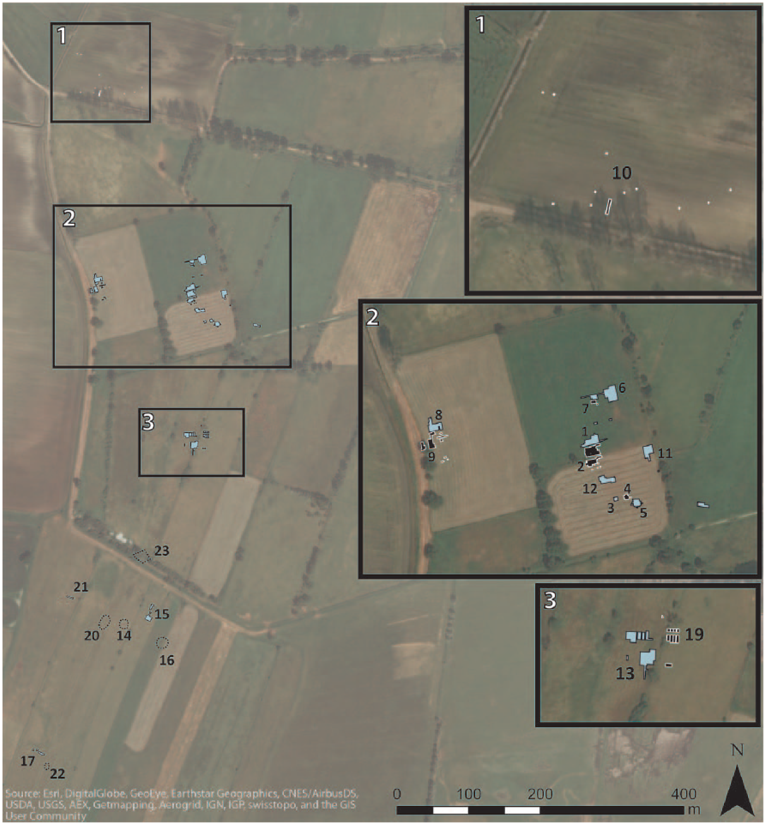
Overview of the sites at ancient Lake Duvensee. The trenches are shown by filled polygons of different colours so that adjacent sites can be more easily differentiated. Sites that are only known from surface finds are shown by unfilled polygons with a dotted contour. The numbers represent the respective site ( ‘Wohnplatz’) names.
Although Jenke (2011) and Holst (2014) have each presented a summary of the hitherto published state of research, and Bokelmann (2012) has finally summed up in a kind of epilogue what he considers to be the most important questions and research results of his almost 40 years of investigation, this paper provides the first overview of all sites excavated in the 20th century in this complex and unique archaeological micro-region. Against a background of intensive ongoing research on the Mesolithic in the Northern European Plain (Groß, 2017; Groß et al., in press; Hartz et al., 2014; Lübke et al., 2011; Mahlstedt, 2015; Schmölcke, 2016; Schmölcke and Nikulina, 2015), it aims to review local Mesolithic developments and to provide an overview of all archaeological activities and sites in the area as well as to present prospects for future analysis.
Environmental history in the Duvensee area between Preboreal and Atlantic
The ancient lake bed at Duvensee was formed during the Older Dryas as a dead-ice hole left by the retreating Fennoscandian ice sheet (Roessler, 1957). The water level rose during the Allerød and the lake reached its largest extent during the early Preboreal (Figure 3; Averdieck, 1986a; Günther, 1986; Schwantes et al., 1925). The water level fluctuated during the late Preboreal and Boreal, but over the course of the Holocene the lake gradually silted up and was overgrown by peat.
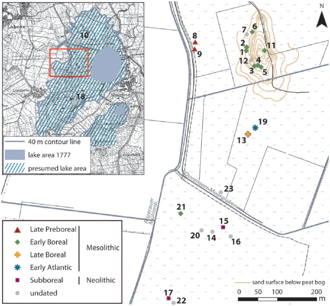
Dating and location of sites in the central western area of the ancient lake Duvensee. Small map: the maximum extent of the lake in the early Holocene (base maps: © GeoBasis-DE/LVermGeo SH).
During the Preboreal, the rapidly rising temperatures and increasing moisture promoted a marked change in vegetation. The Younger Dryas park-tundra landscape (i.e. vegetation dominated by herbs and grasses, but with scattered birch (Betula) trees and possibly rare pines (Pinus; Theuerkauf et al., 2014; Usinger, 2004)) was initially colonized by juniper (Juniperus) scrublands, followed by expanding birch and poplar (Populus) communities (Usinger, 2004). Pine and birch woodlands spread and became denser over the course of the Preboreal, but the overall forest cover remained patchy, with grasslands or tundra-like conditions persisting in dry areas (Nelle and Dörfler, 2008).
The rapid expansion of hazel (Corylus) in the undergrowth of pine forests marks the beginning of the Boreal period. Giesecke et al. (2011) report a widespread rise of hazel in European pollen diagrams, starting from around 8650 cal BC. The apparently simultaneous occurrence of this event at a sub-continental scale suggests climate as a triggering factor; small hazel stands were probably already present before this period, yet their negligible palynological presence might imply that flowering was largely suppressed by unfavourable climatic conditions (Giesecke et al., 2011; Tallantire, 2002; Theuerkauf et al., 2014; Wiethold, 1998). Other studies have produced different estimates of the date of the Preboreal–Boreal transition, from ca. 8820–8750 cal BC in the Netherlands (Bos et al., 2007) to ca. 8100 cal BC in northernmost Germany (Nelle and Dörfler, 2008), reflecting both dating uncertainty and potentially local differences in vegetation development.
Pine and birch were still the dominant forest trees during the early stages of hazel expansion, but gradually succumbed to competition from thermophilous species. Elm (Ulmus) and oak (Quercus) expanded in northern Germany after ca. 8550 cal BC, then were joined by lime (Tilia) and alder (Alnus) after 7000–6500 cal BC (Robin et al., 2011; Theuerkauf et al., 2014). By this time, pine and birch had become secondary forest components, being largely replaced by mixed oak communities (Nelle and Dörfler, 2008; Wiethold, 1998).
The steep rise in the frequency of alder pollen defines the onset of the Atlantic period (ca. 6800–3800 cal BC; Nelle and Dörfler, 2008; Wiethold, 1998) and the full development of mixed oak forests. Alder became a common component in damp depressions and across perilacustrine/riverine vegetation communities (Nelle and Dörfler, 2008). Light-demanding species occurred rarely, suggesting that there were only sparse openings within the dense forest cover (Nelle and Dörfler, 2008). Hazel pollen values declined, arguably, as a result of increased competition from other thermophilous species. Still, hazel remained a notable component of Atlantic forests, probably aided by its ability to withstand shade conditions (Catoni et al., 2015) in a context of growing canopy closure.
The Duvensee sites
The first archaeological finds in the Duvensee bog were made in 1923 by the geologist Karl Gripp, who found Mesolithic artefacts in drainage ditches during an excursion (Schwantes, 1939). Together with the archaeologist Gustav Schwantes, he started the first excavations and ultimately discovered four different sites, only two of which provided valuable material for further analysis (Bokelmann, 1971; Schwantes et al., 1925). Today, these four sites are called Wohnplatz (abbreviated WP) 2 to 5. The German term Wohnplatz, meaning dwelling site, was introduced by Schwantes et al. (1925) as a description for the different find concentrations, and has been continuously used since then for the local kind of Mesolithic activity areas. In 1946, Hermann Schwabedissen excavated another site (WP 1) to clarify questions about the bog stratigraphy (Schwabedissen, 1951). Further intensive research was undertaken by Klaus Bokelmann, whose investigations started in 1966–1967 (Bokelmann, 1971) and lasted until 2001 (Figures 1 and 4). During these years of fieldwork, Bokelmann regularly surveyed the area for surface finds and thus determined areas for future excavations.

The sites WP 1-9 and 11 with the excavated areas and respective investigator (base map: © GeoBasis-DE/LVermGeo SH). The sand surface below the peat bog has been detected by corings. Sites 8 and 9 are located on another small island of unknown extent.
Location of the sites
All of the sites so far investigated at Duvensee are located on small hills that formed islands in the prehistoric lake (Figure 5). Since these islands started to overgrow by peat already during the early Holocene, the sites are not directly located on the mineral soils forming the islands but within the covering organic sediments. Islet 1 is located closest to the western shore of the ancient lake. Two sites (WP 8 and 9) on islet 1 date to the late Preboreal (Bokelmann, 1991, 2012; Bokelmann et al., 1981). The Boreal sites WP 1 to 6, and WP 11 and 12, are located 150 m to the east on islet 2, a sandy island ca. 200 m long and 100 m wide, which was exposed by a lowering of the lake water level during the Boreal. A thin gyttja layer shows that it must have still been under water in the Preboreal (Bokelmann, 1971, 2012).
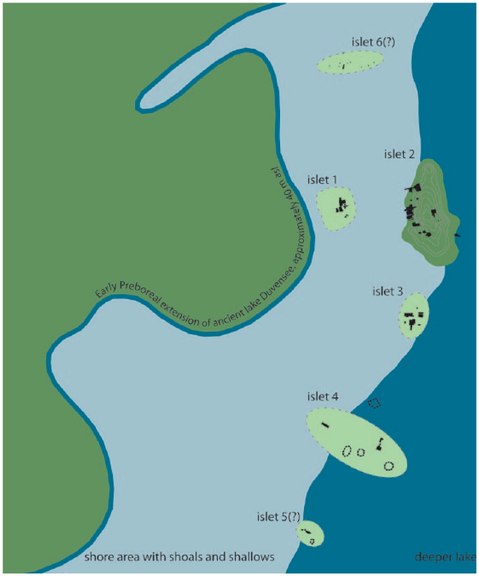
Schematic overview of the islets near the western shore of ancient Lake Duvensee (after Bokelmann, 2012, Figure 2). The trenches are shown as filled polygons. Sites that are only known by surface finds are shown by unfilled polygons with dotted contours (cf. Figure 2). Only the extent of islet 2 is known (shown by dark green colouring).
Further south, two other islands are known – islet 3 with WP 13 and 19 and islet 4 with WP 21 – which were occupied during the Boreal and the early Atlantic. Given the distribution of surface finds, at least two more islets (5 and 6) are expected to the south and north, respectively, of islets 1–4.
Duvensee WP 1
Duvensee WP 1 was excavated by Schwabedissen in 1946. Although he reported two different cultural layers, a later excavation and analysis showed that the supposed layers are the result of a phenomenon known as ‘floating islands’ (Bokelmann, 1971; Jenke, 2011; Troels-Smith, 1951). Duvensee WP 1 and the adjacent site Duvensee WP 2 date to the early Boreal (Bokelmann, 1971). The site WP 1 was small and situated on a reed peat lens, which was surrounded by shallow water. Due to the deposition processes at that site, Bokelmann (1971) states that it remains unclear whether the peat lens was in the original position or drifted into its position as a floating island from another area, though an original position seems more likely. Constructional elements at the site were wooden planks and bark mats, which were placed onto the peat. In the central area there was a fireplace of clay and sand. With a diameter of ca. 1.3 m, it partly overlay the wooden planks and bark mats. A thick layer of hazelnuts, mixed with artefacts, surrounded it (Bokelmann, 1971).
The rather limited number of finds and the small artefact scatter may represent only a short-lived campsite (Bokelmann, 1971). In general, the lithic artefact spectrum is including microlithic points, triangles and core adzes, but appears generally unspecialized, that is, it shows no prevalence of any type or group of artefacts (Bokelmann, 1986). According to Sørensen’s (2006) study of Maglemose lithic blade technologies, it pertains to techno complex 2. As an extraordinary find from this site, a wooden axe fitting made from root wood with a preserved wooden handle was recovered (Figure 6; Bokelmann, 1971). Schwabedissen (1949, 1951); also reported three bone points (two complete and one base fragment), one antler axe blade and other bones (Figure 7).
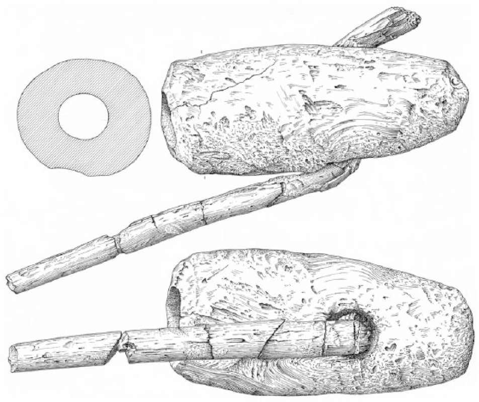
Axe fitting from Duvensee WP 1 (© Archaeological State Museum Schleswig-Holstein).
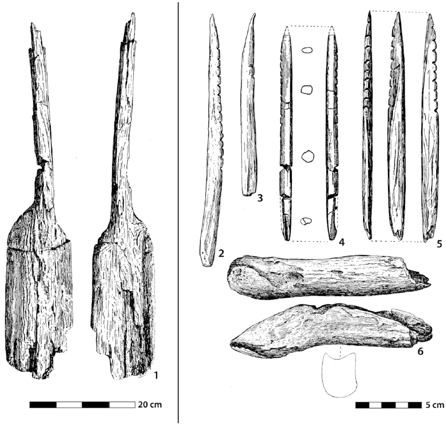
Different organic artefacts from Duvensee WP 1 and 2: 1: paddle; 2–5: bone points 6: antler axe blade. 1–3: WP 2 (after Schwantes, 1939); 4–6: WP 1 (after Schwabedissen (1949).
Duvensee WP 2
Discovered by Gripp and Schwantes in the 1920s (Jenke, 2011; Schwantes, 1928; Schwantes et al., 1925), WP 2 was occupied during the early Boreal (Bokelmann, 2012) but more intensively than WP 1, as proven by a larger number of finds (Bokelmann, 1971). Like WP 1, the site was also subject to stratigraphic changes due to the formation of a floating island (Bokelmann, 1971). Missing documentation of the 1920s excavation makes it difficult to integrate the results into modern re-analyses (Jenke, 2011). However, the site also featured a birch and pine bark layer with a central hearth. An underlay of brushwood and sticks or branches was observed under the bark mats (Schwantes et al., 1925).
The flint assemblage, with microlithic points, triangles and core adzes, can be classified as unspecialized (Bokelmann, 1986) and belongs to Sørensen’s (2006) techno complex 2. Furthermore, two complete and one fragmented bone point, and an antler axe (Jenke, 2011; Kersten, 1951; Schwantes, 1928) were recovered.
A paddle made of pine wood was found in the refuse layer of WP 2 (Figure 7). It is one of the oldest known paddles, and early evidence for the use of watercrafts to move through the landscape. However, two 14 C dates of the paddle measured in 2008 place it in the second half of the Boreal, that is, long after settlement activity at WP 2 (Jenke, 2011). Due to missing detailed information on the find circumstances, it is not possible to finally evaluate the stratigraphic relation of the paddle’s location and the find layers. Thus, the paddle has to be understood as a younger stray find from the site. However, since it was found in the fine detritus gyttja, it can be assumed that the overgrowing process of the lake basin west of Islet 2 was still not completed in the younger Boreal (Bokelmann, 2012).
Intentionally broken bones, that is, remains of game hunting and exploitation, were also recovered at WP 2 (Schwantes, 1928, 1939). Among bones from large and smaller mammal species, such as red deer (Kersten, 1951), wild boar, roe deer, hare and beaver, Schwantes also mentions that numerous fish bones were excavated in the refuse layer at the shoreline.
Duvensee WP 3, WP 4, WP 5
The sites WP 3 and WP 4 were also excavated by Schwantes, but due to the loss of much of the excavation documentation, no precise information is available. Site WP 3 was investigated by a 3.6 × 3.0 m trench, in the centre of which a 1.9 × 1.6 m fireplace was recorded. It consisted of a mixture of sand, charcoal and wood, with the sand mostly covering the charcoal and the wood (Bokelmann, 1971; Jenke, 2009, 2011). At site WP 4, according to the surviving plans, Schwantes found two pine and birch bark mat layers that were separated by a thick layer of cracked hazelnut shells. An oval-shaped charcoal concentration measuring 0.85 × 0.45 m is documented in the southern part of the activity area (Jenke, 2009). However, in comparison to WP 5, these two sites are of minor scientific interest.
WP 5 is one of the most remarkable sites in the Duvensee bog, because Schwantes was able to document five birch and pine bark mat layers, which were stratigraphically separated by intersecting layers of nutshells and fireplaces erected on the bark mats. These seem to have been hazelnut roasting hearths (Bokelmann, 1971; Schwantes, 1928). The complete find horizon was located in reed peat, and the lower lying gyttja contained no finds at all (Bokelmann, 1971). Remarkably, no microliths were reported from the site by Schwantes, and it remains unclear whether they were not recovered, if the site did not yield any, or if they were already lost due to the peat extraction (cf. Jenke, 2011). The rest of the lithic archaeological artefact spectrum seems to be specialized on more domestic activities and woodworking, but this impression might be skewed due to the aforementioned reasons (Bokelmann, 1986).
The age of WP 5 is not proven by radiocarbon dates yet, but pollen analysis showed that it was occupied during the early Boreal, definitely after WP 1 and WP 2, but before the hazel pollen percentages reached the maximum (Schütrumpf, 1981). Nevertheless, the amount of hazelnuts collected here was already huge and leaves the impression of intensified local nut exploitation. Remains of 120–140 nuts were recorded in 5 L of sediment (Beyle in Schwantes, 1928); extrapolating from this number, Holst (2009, 2014) calculated that WP 5 contained the remains of about 30,000 nuts in total, corresponding to 26–30 kg of hazelnut kernels.
Duvensee WP 6
From 1975 to 1977, Bokelmann excavated the site Duvensee WP 6. It has a large central and two ephemeral fireplaces that are surrounded by small pieces of birch bark. The artefacts show a very specialized tool spectrum, comprising microliths production (Bokelmann, 1980, 1986). In detail, two artefact concentrations were detected. The large number of charred hazelnuts found in close connection to the fireplaces renders it likely that they were roasted (Bokelmann, 1980). Similar to WP 1, 5, 11 and 13 (see below) the alternating horizons of yellow sands, charcoal and nutshells led to different hypotheses on the structure of the roasting construction (e.g. Bokelmann, 1980, 1981, 2012; Bokelmann et al., 1985; Lage, 2004, 2011, 2012). The sand was deliberately transported to the camp, since it does not occur naturally on such peat sites (cf. Grøn, 2003 for comparable features at other Mesolithic sites).
Flint and other stones for tool production were probably tested elsewhere, so that only small and homogeneous nodules were ultimately taken to the camp (Holst, 2014). This kind of selection is not seen at the older site WP 8, where apparently unselected nodules were found (see below). Perhaps, the more elaborate tools made on WP 6 required better quality raw material than at WP 8, due to their purpose: around 200 micro burins and an almost similar number of microlithic projectiles indicate that the spot was used for hafting and retooling (Bokelmann, 1980, 1981). Also, two arrow shafts were found at WP 6 (Holst, 2014). Extensive lithic refits indicate that the two ephemeral hearths are slightly older than the central northern roasting facility. While raw material was prepared south of the features, a further refinement of blades into tools took place adjacent to the hearths (Holst, 2014). It seems that the initial flint knapping took place before hazelnuts were roasted at the site, while tool production continued or happened afterwards, as was shown by refits and comparing the different sizes and ratios of burned artefacts and debris (Holst, 2014).
Starting from the settlement area, Bokelmann investigated the nearby shoreline with a 16 m long trench that reached down to the gyttja. Although the preservation conditions for bones should be as good as in comparable bogs, the number of finds was extremely small. Only some very small unidentifiable fragments were found. This result is of particular importance for the interpretation and understanding of WP 6 and probably of other Duvensee sites. Some of them seem to have been used primarily for processing nuts, not hunting. However, the remains of different kinds of specialized flint artefact production show that people brought hunting weapons to these sites and repaired and/or prepared them during their stay (Bokelmann, 1980; Holst, 2014). The role of fishing activities at settlements like WP 6 remains an open question, since it was not possible to wet-sieve the gyttja layers in the course of the excavations.
WP 6 was occupied during the early Boreal, but the exact interpretation of its function and chronological placement is difficult, because radiocarbon dates suggest at least two occupation events within a period of several 100 years (Bokelmann, 1980, 1981). Probably, this site was partly (archaeologically) contemporaneous with WP 5 (Bokelmann, 1980); however, both camps were used during the period of rising hazel pollen percentages.
Duvensee WP 7
During the excavations of WP 6, three small trenches were opened at a distance of 5–9 m to the west of the main trench, just south of the long trench reaching into the shore zone (cf. Figure 4). This area is named WP 7, but only yielded natural wood remains (Holst, 2014; cf. Bokelmann, 1983). It has to be understood as a part of the littoral zone in front of WP 6.
Duvensee WP 8
From 1978 to 1981, Bokelmann concentrated his efforts on Duvensee WP 8, which is located on a shallow island close to the western shore of the ancient lake (islet 1). An 8 m2 bark mat was excavated only 2 m from the water’s edge (Bokelmann, 1991; Bokelmann et al., 1981). In the centre of the mat, which was made out of several layers of birch and in small parts of pine, a hearth was discovered (diameter: ca. 1 m) that had partly scorched the underlying bark mat (Holst, 2014). Comparable to WP 6, this feature was interpreted as a hazelnut roasting facility.
Different concentrations of artefacts show that the working areas can still be reconstructed: microliths were mainly produced in the southern area on the bark mat, as shown by lots of micro burins, whereas flake and core axes are deposited off the mat closer to the shore line. Other small concentrations of flakes and splinters show rather short-term activity areas off the mat (Bokelmann et al., 1981). Despite the supposedly brief occupation of the camp, at least 38 kg of stones were used on the small island. Some were of such poor quality that they were discarded after the first strikes (Holst, 2014). This is in contrast to the situation at other Duvensee sites, in particular to WP 6.
As pollen analyses and five radiocarbon dates show, this site dates to the late Preboreal (Bokelmann, 2012; Bokelmann et al., 1981). Although pollen analyses from the site show that hazel was not yet frequent in the region (Corylus pollen value 5% in relation to all tree species), many cracked hazelnut shells were found, both roasted and unroasted – surely a result of human-gathering activities (Averdieck, 1986a).
Duvensee WP 9
During the excavations of WP 8, lithic artefacts were found in molehills only 7 m further south; the area was investigated by an excavation in 1988-1989. The site (WP 9), which was more disturbed than WP 8, yielded two fireplaces, both built directly on top of a reed peat layer with loam as a base. Several remains of birch and poplar bark might indicate remains of bark mats, but this was not reliably proven (Bokelmann, 1991). It is notable that no hazelnut remains were found on WP 9, which is probably not due to an occupation in a different season, but the palynological results show that the hazel was still very scarcely distributed in the landscape (Corylus pollen value 0.5 % in relation to all tree species; Bokelmann, 1991). Although the radiocarbon dates of WP 8 and WP 9 cannot be chronologically separated due to a plateau in the radiocarbon calibration curve, the Corylus pollen values indicate that WP 9 must be slightly older (Bokelmann, 1991, 2012). Furthermore, it was not possible to find refits of lithic artefacts between WP 8 and 9, hence underlining a temporal difference (Holst, 2014).
Duvensee WP 10
WP 10 is located ca. 300 m north of the extensively investigated central area of the western shore of ancient Lake Duvensee. Surface finds from an amateur collection indicate an early Mesolithic assemblage, but it was assumed that the site was completely destroyed by amelioration work. However, in 2017 a small test trench has proven that undisturbed layers are preserved. Although still without chronologically significant artefacts, the site seems partly intact, despite it not being clear to what extent.
Duvensee WP 11
One of the most complex sites excavated at ancient Lake Duvensee is WP 11. Here, between 1997 and 2001, not only thousands of flint artefacts and huge quantities of partly charred hazelnuts were documented, but also four different hearths/roasting facilities, as well as a stratigraphic sequence of ca. 20 bark mats. These mats, mainly made out of birch bark but also out of pine bark, were refitted and repaired several times (Bokelmann, 2012; Sørensen et al., 2018). As at WP 5, one of the fireplaces was placed on top of a birch bark mat, but the other fireplaces suggest that this was not the standard construction method (Lage, 2004, 2011; but cf. Bokelmann, 2012). As already observed at WP 8, the flint nodules transported to WP 11 are unspecific with respect to quality and knapping suitability, but it can be assumed that they also origin from the moraine hills in the surroundings of the former lake (Bokelmann, 2012). However, WP 11 has been occupied repeatedly. It is younger than WP 8 and dates to about 8500 cal BC, that is, the beginning of the Boreal (Figure 8).
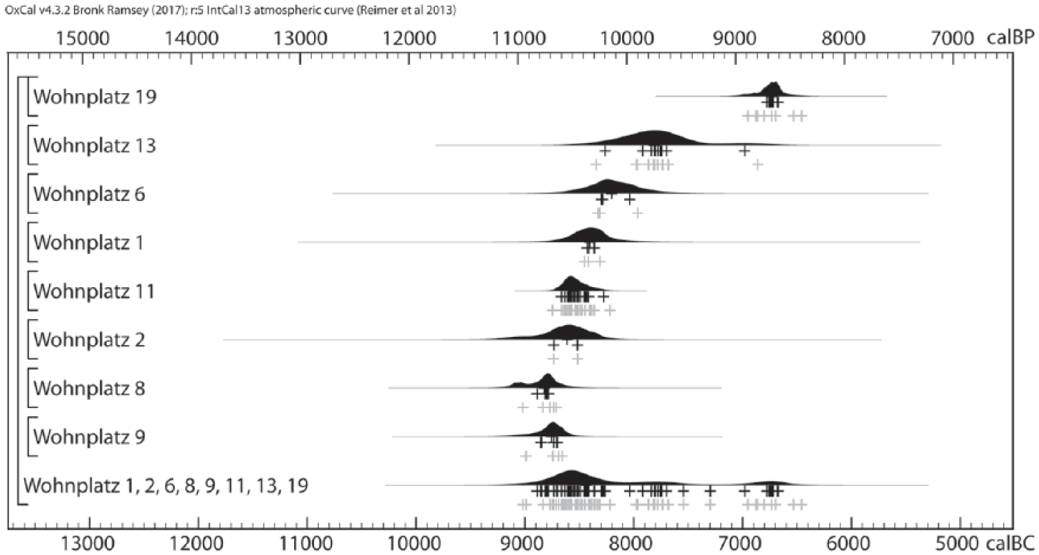
Radiocarbon dates of the Duvensee sites ( ‘Wohnplatz’), calibrated with OxCal v. 4.3.2 (Bronk Ramsey, 2009) and the IntCal13 calibration curve (Reimer et al., 2013). Each distribution is a kernel density estimate of the temporal distribution of datable material from each site, based on the calibrated dates of the dated samples (KDE_Model: Bronk Ramsey, 2017). The crosses show the median dates of single samples (grey: unmodelled, black: modelled). See also text for further details. After Bokelmann, 1971 (WP 1), 1986 (WP 13), 1991 (WP 9), 1995 (WP 19), unpublished (WP 11); Bokelmann et al., 1981 (WP 2, 6 and 8), 1985 (WP 13); Willkomm, 1986 (WP 13; graphic and analysis: John Meadows, ZBSA).
Duvensee WP 12
Duvensee WP 12 is a small area on the same island as WP 1–7 and 11 that was investigated by Bokelmann in 1996. However, although some lithics were found, this excavation did not provide any clear settlement structures (Jenke, 2009). Therefore, investigations were not continued. It is unpublished.
Duvensee WP 13
WP 13 is located on islet 3, ca. 150 m south of islet 1. An area of ca. 90 m² was excavated in 1982–1985. The campsite was established between the water’s edge and a group of pine trees (Bokelmann, 1986; Bokelmann et al., 1985). The excavations showed three concentrations of artefacts: one area with a bark mat and an associated micro-burin concentration, a central fireplace with indications that it had been cleared out and a toss zone in the shallow water. Refits indicate that the shallow water zone could have been dry during occupation (Bokelmann et al., 1985; Hausmann, 2012). The number of hazelnuts is rather small, so that – in contrast to WP 6 – the site is not interpreted as a hazelnut roasting facility (Bokelmann et al., 1985). The lithic inventory of the site features microliths and intentionally broken blades. Although slender scalene triangles are found, handle cores as well as axes are completely lacking (Bokelmann et al., 1985; Hausmann, 2012).
In another area of the site, features were revealed that draw a very precise image of prehistoric processes. Again located on peat, a birch bark mat, a fireplace, some hazelnut shells, flint artefacts, and birch and pine stumps were found (Bokelmann, 1986). The stumps are preserved remains of trees that were growing during the use of the site. Two small concentrations of hazelnut shells were found between the bark mat and the fireplace, which were cracked with a knapping stone that was still in situ (Bokelmann, 1986).
However, as the archaeological assemblage shows, roasting hazelnuts was one, but not the main activity at WP 13, even though the pollen diagrams from the site provide ‘high hazel pollen values (up to 120% of all tree species)’ (Bokelmann, 2012: 377). An explanation for the low amount of hazelnuts may be seen in an episodic bad yield, but it is also possible that the ecological conditions had already gradually changed towards a forest with dominance of competitors for hazel such as oak, elm, lime and alder so that the productivity of hazel had already been reduced. Bokelmann (2012) concluded that WP 13 could therefore have been the last site in the early Mesolithic sequence of hazelnut roasting activities in the Duvensee area. Eleven radiocarbon dates place the occupation of WP13 at ca. 8000 cal BC (Figure 8).
Another bark mat, which dates to the early Atlantic, was found near the eastern border of the trench, in a higher stratigraphic position. No artefacts were found in direct association with the mat, but a small fireplace was built on a sand base on top of the mat (Bokelmann, 1989). With respect to its age and the lack of finds, this section of WP 13 resembles WP 19.
Duvensee WP 19
WP 19 is different from most of the other campsites in the Duvensee bog, because it is not a product of single or closely related events, but contains the remains of several isolated activities. The central feature is a 2.3 m long and 0.7 m wide pine bark mat without any other traces of human activity (Bokelmann, 1995). It has a comparable age to the pine bark mat from WP 13. At a distance of 2 m, some smaller birch bark mats which might have suited for seating were uncovered. The excavation also revealed different charcoal concentrations and latent fireplaces, some of them with sand at their bases. Only 74 (indistinct) lithic artefacts were collected, and none of them could be connected to any of the features (Bokelmann, 1995). As radiocarbon datings show, the main period of occupation was probably during the first half of the 7th millennium BC, that is, the early Atlantic (Figure 8), making WP 19 the latest Mesolithic occupation recorded in the Duvensee bog.
Duvensee WP 21
WP 21 was partly excavated by Bokelmann with a 6 × 2 m trench in 1987. A hearth construction with a mixture of charcoal, burned hazelnut shells and sand was recorded in the western part of the trench, while most of the artefacts and a few much smaller charcoal concentrations were found in the eastern half. Two radiocarbon dates from the hearth construction place the site in the Boreal 1 which is in agreement with the lithic inventory, with typical triangle microliths, but further analyses have not been done yet. This is also due to the fact that part of the lithic finds were extremely degraded due to desilication so that the artefacts were soft and disintegrating.
Duvensee WP 15 and 17
WP 15 and WP 17 are different from the other sites because they are not of Mesolithic, but of Neolithic age. WP 15 is located on another small island (islet 4), close to the western shore of the former lake. It was partly excavated in 1994 and can be dated to the Single Grave Culture, around 2600 cal BC (Jenke, 2009). A hazelnut roasting structure was found here as well, showing that Neolithic farmers also gathered nuts as a part of their diet. New excavations were conducted by Jan-Piet Brozio, Christian-Albrechts-University Kiel, in 2017.
Duvensee WP 17 was investigated in 1987 by Bokelmann. A 19 m² trench and two 1 m² test pits were excavated. No structural remains could be identified. Due to surface finds of flint blades produced with an indirect punch technique, a late Mesolithic date was expected. However, typical pot sherds and lithic artefacts of the early Funnelbeaker culture, and one radiocarbon date confirmed the early Neolithic age of the site (Lübke, 2000). Nevertheless, technological analysis of the lithic inventory, including the blades, showed striking parallels to late and Terminal Mesolithic assemblages in Northern Germany, and thus the comparable lithic technology proves a continuity of cultural traditions from the Ertebølle to the early Funnelbeaker Culture (Hartz and Lübke, 2012; Lübke, 2000).
Duvensee WP 14, 16, 18, 20, 22, 23
Several sites in the Duvensee area are only known from surface collections. Since these materials have not been analysed in detail, they are only briefly described to complete the picture. All sites are unpublished.
The sites WP 14, 16 and 20 are located east and west of WP 15. The sites are only known by surface finds and, according to these, probably belong to the same Neolithic settlement (cf. Figure 5).
WP 18 is located in the southern centre of the former lake and ca. 1.5 km south of the cluster of sites (Figure 3; cf. Averdieck, 1986a; Bokelmann, 1991). Since it is only known from surface finds, further investigations are needed to demonstrate the character and date of the site.
Duvensee WP 22 is a surface find area slightly south-west of WP 17. The character, dating and extent of the site remains unclear.
The site Duvensee WP 23 was introduced after a Mesolithic core was found in a burrow. However, a test excavation in 2017 could not demonstrate the preservation of any find layers.
Characteristics of the sites from Duvensee
During the past decades, much analysis has been conducted on the internal structure of the early Mesolithic sites in the Duvensee bog. It was possible to detect different activity areas and thus enable a solid understanding of internal site organization at several of these sites (WP 6, 8, 9 and 13). In some cases, small-scale analyses provided insights into the processes and chronological order of different actions (WP 6, 8 and 13). It becomes clear that the sites reflect different specialized functions and also different durations of use.
In particular, the older sites WP 1, 2 and 8 show the intensive exploitation of plant resources. Hazelnut shells are well known as the most common plant remains found at Mesolithic sites in Scandinavia and northern Central Europe, and these nuts must have played an important role in foraging (e.g. Cappers and Ytsma, 2005; Holst, 2010, 2014; Mithen et al., 2001; Regnell, 2012; Warren et al., 2014; Woldring et al., 2012). Hazelnut exploitation was surely already systematic and intensive (sensu Zvelebil, 1994). But it is important to keep in mind that the role of nuts is easily overestimated and generally difficult to compare with other food sources (Divišováa and Šída, 2015; Groß, 2017; Leesch et al., 2017; Leesch in Richter et al., 2015). It is still under discussion whether hazel was promoted by human activity (Bokelmann, 1980; Clarke, 1978; Kuneš et al., 2007; Tallantire, 2002; Woldring et al., 2012; c.f. Warren et al., 2014), as is known from some recent foragers (Greaves and Kramer, 2014; Headland et al., 1989; Solway and Lee, 1990). Besides nut harvesting, the importance of hazel is testified by the occurrence of tools made of hazel wood, for instance, an arrow shaft from WP 6 (Holst, 2014). It might be possible that Mesolithic people observed that pruned hazel trees produce new shoots with a richer yield of nuts, and potentially utilized this actively.
Several of the Duvensee sites show a limited activity spectrum, either by a rather limited number of finds, or a specialized artefact spectrum and evidence of hazelnut processing (WP 1, 6, and 11). The latter especially highlights the (archaeological) contemporaneity of different actions like hazelnut processing and microliths production, as seen at WP 6 and 8 (Bokelmann, 1980; Holst, 2014)). By contrast, some sites provided hazelnut shells, but not in such vast numbers that they can represent one of the primary purposes for the site. This highlights that the sites in Duvensee should not be solely understood as nut harvesting camps, even though the nuts indicate an occupation during autumn. Moreover, large numbers of microliths demonstrate lithic preparation and hafting-and-retooling activities (Bokelmann et al., 1985). Indications for the reworking of hunting equipment are also found at site WP 6. By comparison, the artefact spectrum of WP 5 seems to be very specialized and due to the lack of microliths it is doubtful that hafting and retooling of arrow shafts took place here, too. Several of the excavated sites have an unspecialized artefact spectrum (WP 1, 2, 8, 9 and 11). Extensive hazelnut processing (gathering and roasting) is recorded at five sites (WP 1, 6, 8, 11 and 15), whereas bark mats in variable numbers are known from up to nine camps (WP 1, 2, 4, 5, 8, 9(?), 11, 13 and 19; Table 1). It is worth mentioning that roasting facilities were not just used for hazel processing but rather have to be seen as a general facility for food processing (Bokelmann, 2012) and possibly as a mean to get rid of midges. Several burned fish bones, for instance, found at WP 11 prove the consumption of aquatic resources. Also, burnt bone fragments have been found at WP 6, WP 9 and WP 13 (Bokelmann, 1991, 2012; Bokelmann et al., 1985; Holst, 2014) as well as notched bone points (WP 1 and 2) that indicate hunting or fishing, thus highlighting that hazelnuts have not been the only dietary resource that has been processed in the hearths.
Overview of the excavated sites from Duvensee with a selection of specific characteristics. It becomes clear that the sites are different from each other in various aspects.

Schwantes (1928) mentions that water chestnut (Trapa natans) was growing in the lake, which was a possible staple as well. However, neither in the reanalysis of the pollen diagrams nor during the excavations, remains of such plants were found.
The ongoing discussion of the construction of the individual hearths with the long-time member of the excavation team W. Lage (2004, 2011), shows very clearly that further detailed investigations are necessary here. In principle, since the mineral sediment used for the construction and the profiles of the different roasting facilities is quite diverse, it can be concluded that these hearths were not constructed following a uniform design scheme. This may well be connected with different purposes of the features or chronological differences.
The different sites at ancient lake Duvensee did not all have the same artefact spectrum, or reflect the same subsistence strategy. Consequently, the camps served very different purposes, potentially reflecting differences in the socio-economic behaviour and partly, seasonality of occupation. Although most sites provided hazelnut remains, processing them in large numbers as a staple was only important at a few. With respect to a growing insight into Mesolithic subsistence patterns and lifeways, it becomes increasingly clear that the behaviours and coping strategies of these people were manifold (cf. Cappers and Ytsma, 2005; Divišováa and Šída, 2015; Groß et al., submitted; Leesch et al., 2017; Regnell, 2012; Sørensen et al., 2018; Schmölcke, 2016). Hence the sites at ancient Lake Duvensee have to be seen as episodes of prehistoric lifeways but not as general representations of a whole economy. Considering the growing evidences for the use of aquatic resources (e.g. Boethius, 2017; Meadows et al., in press; Robson, 2016) in the early Mesolithic in general, the role of fishing is likely to have played a role in Duvensee as well, even though evidence is scarce. Despite the evidence of hafting and retooling, direct evidences for hunt, that is, animal bones, are rare at the sites. Thus, they are clearly contrasting contemporaneous Mesolithic sites like Hohen Viecheln (Schuldt, 1961; Groß et al., in press) or Friesack (Gramsch, 2002, 2011; Groß, 2017) in northern Germany or Star Carr in England (Milner et al., 2018). This makes them important for contextualizing human behaviour, social transformations and environmental changes in the northern European Mesolithic. One aspect all sites have in common is that people settled on degraded peat. This is partly relevant for the preservation of the sites, but sheds another light on the settlement strategy and choice of areas of Mesolithic people. While it is yet unclear if only specific conditions, for instance, climatic or weather conditions like very dry seasons, fostered the use of the ancient lake area and consequently the settling on peat, future studies need to show which specific factors influenced local settlement patterns.
Prospects for further investigations
Analyses of archaeological remains and environmental data increasingly reveal the behavioural dynamics of early Mesolithic societies and their manipulations of the landscape. The growing detail in the analysis of Mesolithic sites increasingly shows that people did not only react within their environment but were actors in extensively shaping it themselves (Bishop et al., 2015; Blockley et al., 2018; Boethius, 2017; Klooß, 2015; Law, 1998; Starkovich et al., 2018; Warren et al., 2014). Since the evidences for the ecological impact of prehistoric hunter-gatherers is still scarce and scattered, specific explanations for prehistoric decision-making and social transformations may be obtained if detailed reconstruction of past conditions are analysed. Since ancient lake Duvensee provides pristine conditions to analyse past societies against an ecological background in transformation, it enables us to determine the role and impact of technological changes, local phenomena and human behaviour in a diachronic perspective.
The vast archaeological and palaeo-ecological records from ancient Lake Duvensee permit small-scale variations in site use and chronology to be understood. Therefore, the area has a high potential for understanding the interaction of environmental change and human societies. In future studies, high-resolution chronological analysis, including more detailed seasonality analysis, can thus show how humans as well as the environment reacted to external forcing, for example, climate events or shifts, and related consequences. Since the different sites cover the Mesolithic over a rather long time span (Figure 8) while being largely free from later intrusions, detailed typo-chronological studies of the material are possible (Bokelmann, 1999, 2012; Holst, 2008). Palaeo-topographical analyses, lake-level reconstructions and sedimentation analysis can furthermore help to see how different seasons or climatic events (e.g. Preboreal Oscillation, 9.3- or 8.2-event) are reflected in the local hydrology and vegetation, and consequently how this influenced human subsistence and settlement behaviour.
Most of the former studies on the Duvensee sites explicitly addressed the internal structure of sites (Bokelmann, 1986, 1989, 1991, 1995; Bokelmann et al., 1985; Holst, 2014) or the relevance of single resources (Bokelmann, 1980; Holst, 2009, 2010, 2014). Contextualizing sites within Duvensee and beyond the area has only been cursorily done many decades ago (Bokelmann, 1981). Palaeo-ecological analyses were hitherto also mainly restricted to archaeological purposes, that is, dating of sites (Averdieck, 1986a, 1986b; Bokelmann et al., 1981, 1985), rather than being regarded as essential for understanding the history of the ancient lake area. Further investigations therefore need to address the area from a modern interdisciplinary perspective, enabling different viewpoints and scales of analysis to provide a more solid (pre-) history of ancient Lake Duvensee on one hand, and, on the other, shift the perception of past landscapes from an entirely anthropocentric view to a more holistic picture. Eventually, this may help to recognize when, where and how different triggers interplayed before (parts of) societies, behaviour or ecosystems transformed or collapsed.
Footnotes
Acknowledgements
We would like to thank John Meadows and Walter Dörfler for valuable comments and discussions of the text as well as the long-time excavator and researcher of the Duvensee bog sites, Klaus Bokelmann, for detailed information on the individual sites, which goes far beyond the information published so far. Furthermore, we thank the two anonymous reviewers for their valuable comments on the text.
Funding
The running investigations of Mesolithic in the Duvensee bog are part of the Collaborative Research Centre 1266 ‘Scales of Transformation–Human-Environmental Interaction in Prehistoric and Archaic Societies’ funded by the German Research Foundation (DFG). For the Centre for Baltic and Scandinavian Archaeology (ZBSA), the research has been undertaken within the framework of the Strategic Research Theme ‘Man and Environment’. Preliminary work on the project was financed with own funds from the ZBSA.