
Abstract
Marginal moraines on the northern side of Grovabreen, a plateau glacier in inner Sunnfjord, Western Norway, have been mapped and morphostratigraphically correlated with the Erdalen Event and possibly the Finse Event and the ‘Little Ice Age’. Schmidt-hammer exposure-age dating was used to evaluate the age of the most distinct marginal moraines by measuring the degree of surface weathering on boulders. The lithostratigraphy of lake sediments was analysed in a core from Dalevatnet in order to correlate this stratigraphy with the marginal moraines in the catchment area of the lake and reconstruct the early-Holocene history of Grovabreen. The lake catchment was deglaciated at 10,750 cal. yr BP. Two readvances of an outlet glacier in Fagredalen were dated to between 10,340 and 9960 cal. yr BP, correlated with the two-peaked Erdalen Event. A readvance shortly after 8450 cal. yr BP can most probably be correlated with the 8200 cal. yr BP Finse Event.
Keywords
Introduction
Early-Holocene marginal moraines have been mapped in front of several glaciers in Western Norway. They are important sources of information on Holocene climate change. But the large glacier advances of the ‘Little Ice Age’ (LIA) have erased many of the earlier moraines ( Grove, 1988), particularly in southern Norway. This is in contrast to northern Scandinavia, where the scale of pre-LIA glacier expansion episodes was of the same order as or exceeded that of the LIA (Karlén, 1976, 1988). Several glacial readvances from the Jostedalsbreen ice cap followed the retreat of former fjord and valley glaciers of the early Holocene, but only one of the readvances has been recorded by marginal moraines. This was the Erdalen Event, which involved the formation of prominent terminal moraines in front of some of the outlet glaciers. Examples of pre-LIA moraines in front of Jostedalsbreen outlets are located at Briksdalsbreen and Melkevollsbreen (Pedersen, 1976), Erdalen (Nesje, 1984), Nigardsbreen (Sønstegaard and Aa, 1987) and Bøyabreen (Aa and Sjåstad, 2000).
So far no moraines between the Erdalen and LIA moraines in age have been recorded in southern Norway, except perhaps in eastern Jotunheimen.
Marginal moraines of suggested early-Holocene age have also been mapped and reported from the northern side of Grovabreen in Sunnfjord (Aa, 1986, 2006) and around the Hardangerjøkulen glacier (Dahl and Nesje, 1994, 1996). Around Nordre Folgefonna (Bakke, 1999; Bakke et al., 2005a), the moraine chronology in front of outlet glaciers indicates up to seven successively smaller glacier halts or readvances with deposition of marginal moraines.
Glaciofluvial sediments in proglacial lakes have been used to reconstruct Holocene glacier variations. Nesje et al. (1991), Nesje and Dahl (1991), Dahl and Nesje (1992), Karlén and Matthews (1992) and Matthews and Karlén (1992) dated glaciofluvial sediments in proglacial lakes and reconstructed glacier readvances and retreats during the early and late Holocene.
The Erdalen Event was first reported by Nesje (1984) in the valley Erdalen northwest of Jostedalsbreen, where glacier advances, or readvances, left two sets of marginal moraines (Nesje et al., 1991; Nesje and Kvamme, 1991). The formation of the moraines in Erdalen was initially dated to close to the Preboreal/Boreal transition, based on a basal date from a peat bog 300 m proximal to the moraines (Nesje, 1984). Later, it was suggested that the glacier advances took place at 10,300 to 9700 cal. yr BP (Nesje et al., 1991).
Sediments deposited from a local cirque glacier in Sunnmøre yielded maximum and minimum dates of 10,450 and 10,005 cal. yr BP, respectively (Eikeland, 1991). The Erdalen Event has also been identified stratigraphically in front of a number of small local glaciers and outlets from Jostedalsbreen. The time of formation of the Erdalen Event moraines was dated stratigraphically in a peat bog beyond the outer LIA moraine (historically dated at AD 1748 in front of Nigardsbreen), to 10,100 and 9700 cal. yr BP (Dahl et al., 2002).
The early-Holocene glacial advances, as indicated by the marginal moraines in Fagredalen to the north of Grovabreen, have not previously been dated. A sediment core was therefore collected from the proglacial lake Dalevatnet in order to provide a record of glacial variations. South of Grovabreen, the Holocene history has been inferred from radiocarbon-dated sediments in a core from Grøningstølsvatnet (Seierstad et al., 2002). Dating indicated that the glacier disappeared from the area at ca. 9500 cal. yr BP, and did not reappear until 8200 cal. yr BP, during the Finse Event. The glacier melted away again between ca. 8000 and 4500 cal. yr BP, and became reestablished after that (Nesje, 2009; Seierstad et al., 2002).
Dahl and Nesje (1994) recorded glacial advances in Western Norway in the early Holocene, ca. 8200 cal. yr BP. Nesje et al. (2006) used glaciolacustrine sediments in Vanndalsvatnet downstream of Spørteggbreen east of Jostedalen to reconstruct the Holocene palaeoclimate, with particular reference to the 8200 cal. yr BP event. The area was deglaciated around 10,200 cal. yr BP, and there were then several short-lived glacial fluctuations until about 8000 cal. yr BP. The Holocene history of northern Folgefonna has been reconstructed from lake sediments by Bakke et al. (2005b, 2005c). The lake record extends back to ca. 11,000 cal. yr BP, including glacier episodes Jondal Event 1 at 11,100 cal. yr BP and Jondal Event 2 between 10,550 and 10,450 cal. yr BP (Bakke et al., 2005a).
After the Finse Event at 8200 cal. yr BP, which can be identified at Jostedalsbreen, this glacier experienced two minor advances at 7700 and 7400 cal. yr BP, after which the ice cap disappeared completely between 7300 and 6100 cal. yr BP. Gradual climate deterioration during the latter part of the Holocene caused increased glacier activity from 4000 cal. yr BP (Dahl and Nesje, 1994, 1996; Nesje and Dahl, 1991; Nesje et al., 1991; Nesje and Kvamme, 1991). During the last 4000 years, there have been several climate fluctuations. Increased peat growth indicates higher precipitation (Matthews, 1991; Nesje, 1984), and there is also evidence of this at Grovabreen.
Since 4700 cal. yr BP, Grovabreen has existed continuously, as shown by the Grøningstølsvatnet lake sediments, especially the content of fine and medium silt (Seierstad et al., 2002). Several marginal moraines east, north and south of Grovabreen indicate that it reached its maximum neoglacial extent during the mid-18th century. The most extensive Holocene glacial advance in Western Norway took place during the LIA (Bickerton and Matthews, 1993; Matthews, 1991). Little is known about the history of the northern part of Grovabreen. The aim of this study was to reconstruct the Holocene history of this area by dating proglacial lake sediments in Dalevatnet and evaluating the age of marginal moraines in Fagredalen by Schmidt-hammer exposure-age dating.
Study area
Grovabreen is a small plateau glacier southwest of Jostedalsbreen (Figure 1), covering an area of 20.84 km2. The glacier ranges in altitude from 1615 to 1090 m a.s.l. (Østrem et al., 1988), giving an altitudinal difference of 525 m. There are three short north-facing outlet glaciers from the plateau: Fagredalsbreen, Vidunderdalsbreen and Breelvskardbreen farther east.
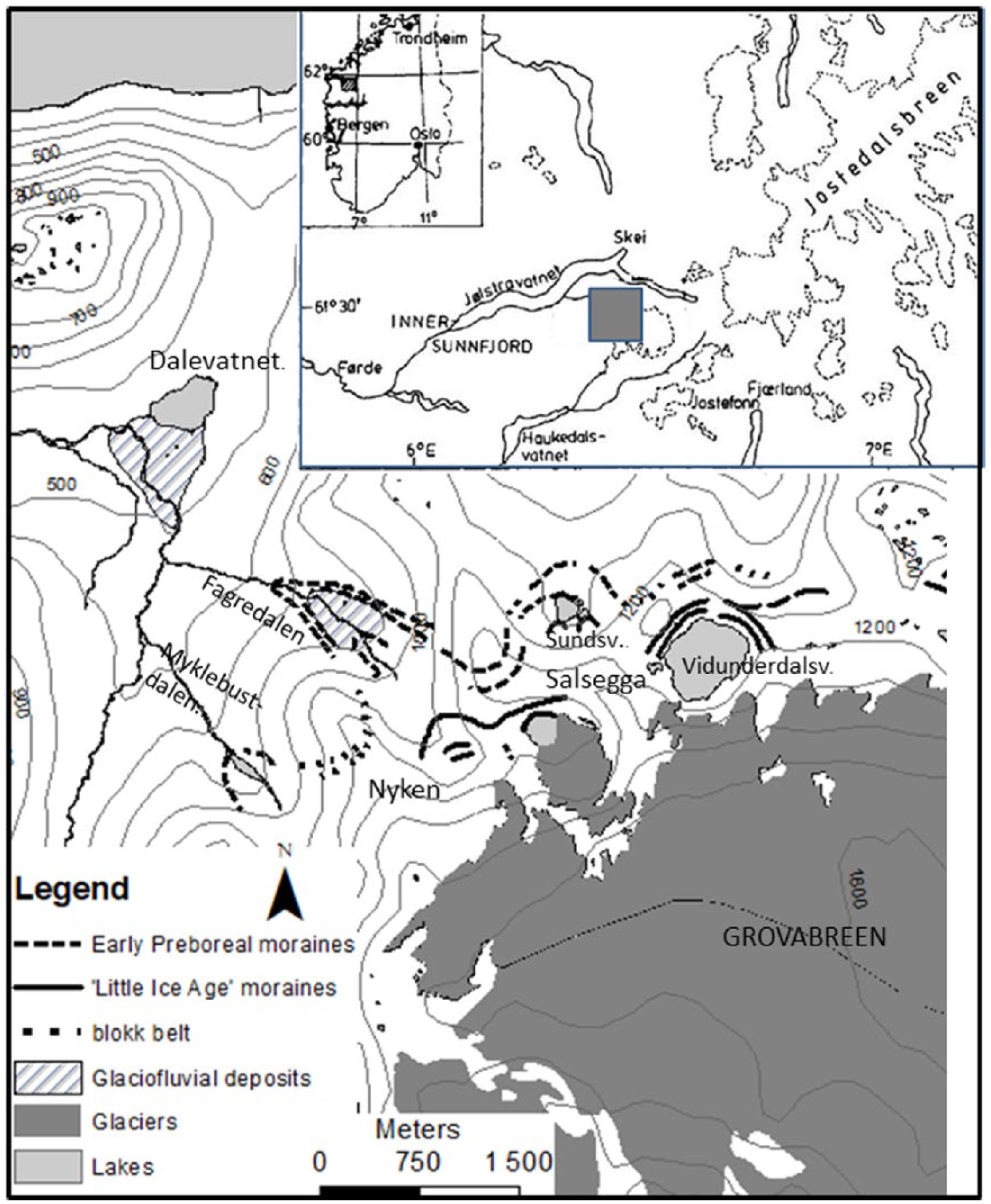
Location of the study area showing marginal moraines, glaciofluvial deposits and lake Dalevatnet.
The equilibrium-line altitude (ELA) in the glacier area is between 1400 and 1500 m a.s.l. (Aa, 1996). The glacier has a rather small accumulation area of about 10 km2, most of which lies slightly above the ELA. Near Grovabreen, the mean annual temperature is 3°C at 500 m altitude, and 0°C at 1000 m. Mean winter precipitation at Skei in the period 1980–1991 was 1020 mm. The distance from Skei (Figure 1) to Grovabreen is 6 km. The climate station in Haukedalen at 340 m a.s.l. and 5 km from the glacier margin, with mean precipitation of 1470 mm (1980–1991), is perhaps more representative of the north-facing area of Grovabreen. If we assume similar amounts of precipitation on the glacier, and an increase of 8% per 100 m rise (Haakensen, 1989), the mean winter precipitation at 1300 m is 1917 mm.
The bedrock north and west of Grovabreen consists of Precambrian gneiss and partly banded gneiss. In the eastern part of the glacier, there is coarse-grained quartz monzonite and in some places augen gneiss (Lutro and Tveten, 1996).
At the northern margin of the plateau glacier, there are a number of deep glacial cirques. Some of them contain lakes, such as Vidunderdalsvatnet (1135 m a.s.l.). Others are filled with glaciers, for example, the upper end of Fagredalen (Figure 2). For many years, the river from Fagredalen drained into Dalevatnet at 473 m a.s.l. This lake is about 6 m deep and covers an area of ca. 0.6 km2. The area around the lake consists of nearly flat bogs.

Fagredalen showing marginal moraines on each side of the river. On the eastern (right-hand) side, the marginal moraines can be traced across the mountain Nuken. M1 and M2: Erdalen Event moraines, M3: Presumed Finse Event moraine, M4: The ‘Little Ice Age’ maximum moraines.
In Fagredalen, there is a gently sloping valley bottom from 700 m a.s.l up to a steep slope from ca. 800 to 900 m a.s.l. (Figure 2). Further up there is a glacial cirque with an outlet at 960 m and a back wall rising to 1100 m a.s.l., where a small lake appeared in 1997 after melting of the outlet glacier.
The river from Myklebustdalen (Figure 1) also used to drain into Dalevatnet. The outermost marginal moraines in Myklebustdalen are connected with those in Fagredalen by a block belt across the Nuken mountain ridge.
The superficial deposits are mainly a thick cover of till and peat. Dvergsdalsdalen has outlets both to the north and to the west where marginal moraines have been mapped (Aa, 1996, 2006; Klakegg, 1981; Klakegg and Rye, 1990).
The largest marginal moraines of the study area are at the mouth of Fagredalen at ca 700 m. Further upvalley towards the present glacier there are a number of marginal moraines. There are also three eroded gullies on the steep eastern valley slope. They have been eroded along the lateral moraines. Beneath each gully, a fan has been deposited on the valley floor of Fagredalen at 780 to 800 m a.s.l.
The river Fagredøla has eroded a channel, 5–10 m deep and ca. 100 m long, in a steep slope beneath the moraines. Fagredøla has also eroded a channel from about 700 to 500 m a.s.l. east of Dalevatnet, and has deposited material in the Western part of Dalevatnet (Figure 1), forming a delta nearly 1 km long.
Today, the rivers from Fagredalen and Myklebustdalen run along the Western, lateral margin of the delta and not into the lake. This appears to be because the river that used to run out of Dalevatnet eroded a deeper channel into which Fagredøla now runs 150 m west of Dalevatnet.
Methods
A Quaternary map showing marginal moraines and superficial deposits in the area north of Grovabreen has previously been drawn based on a combination of fieldwork and aerial photos (Aa, 1997, 2006).
Schmidt-hammer rebound values (McCarroll, 1994) were recorded and used to evaluate the degree of weathering as an indicator of the surface age of moraine boulders. Boulders with similar lithology were used, mainly gneiss with anisotropic orientation of mineral grains (McCarroll, 1990).
To obtain an old reference (R1), 50 blows were made on the rock surface at 800 m a.s.l. on the mountain ridge NE of Dvergsdalsdalen, where deglaciation is estimated to have occurred at about 11,000 cal. yr BP. Freshly exposed boulders near the newly built hydropower dam in Fagredalen were chosen as a young reference (R2). An exposure age of 10 years was used at this site.
Two sediment cores were collected near the middle of the ice-covered Dalevatnet in December 1997, at a water depth of 6 m (Figure 1), which was the deepest of six depth measurements. The corer used was a modified Livingstone piston corer which can obtain a 6-m sediment core, 110 mm in diameter (Nesje, 1992). Core 2 was used to analyse loss-on-ignition (LOI) and magnetic susceptibility (MS; 10−5 SI).
LOI is sensitive to glacial minerogenic sediment input (Karlén, 1976; Nesje et al., 2006; Seierstad et al., 2002). Measurements were obtained at 1 cm intervals. The samples were dried overnight at 105°C in ceramic crucibles and weighed. The samples were ignited for 1 h in a furnace. The crucibles were then cooled in a desiccator and weighed at room temperature. LOI values were calculated as a percentage of sediment dry weight.
MS measurements were carried out at 2 cm intervals using a Bartington MS2B sensor. MS depends on the concentration of magnetic minerals within the sediments and provides information on erosion and sediment transport of processes. MS varies inversely with LOI (Karlén and Matthews, 1992; Matthews et al., 2000; Nesje et al., 2000, 2001; Seierstad et al., 2002). Core 2 was split and a systematic description was made of bands and layers of gyttja, silt and fine sand.
Eight accelerator mass spectrometry (AMS) radiocarbon dates were obtained from the 110-mm core 2 from Dalevatnet. The samples were generally 1 cm thick. Dating was carried out at the University of Utrecht, Holland, and at Beta Analytic, Inc., Florida, US. Standard procedures for AMS radiocarbon dating were used (Table 1). The radiocarbon dates were corrected for ∂13C. Radiocarbon dates were converted to calendar years BP (BP = AD 1950) using CALIB 7.10 (Stuiver and Reimer, 1993). When there were more than two calculated intercept ages, the median value was used.
AMS radiocarbon dates obtained from core 2 Dalevatnet.

AMS: accelerator mass spectrometry.
Results
Fagredalen marginal moraines
Four large, distinct marginal moraines have been detected in Fagredalen, and between them two to three smaller ridges on the valley floor, which are partly covered by glaciofluvial sediments and peat.
The outermost marginal moraine M1 (Figure 2) is by far the largest, 10 to 11 m high on the steep distal side, and it can be described as a moraine complex with two to three close parallel ridges. This moraine can be traced from 670 to 900 m a.s.l. on the northern side of the valley. Further up the slope the moraine ridges have been damaged by mass movements.
The southern margin of the outermost Fagredalen lateral moraines can be traced as a block belt across Nyken from 1150 m down to the corresponding Myklebustdalen moraine.
In total, 200 Schmidt-hammer blows were made on boulders at the top of the M1 moraine. The mean value of rebounds was 35.2, which indicates a rather high degree of weathering (Figure 7).
The M2 marginal moraine (Figure 2) is discontinuous and up to 7 m high. The mean rebound value of 100 blows on M2 was 34.6, that is, a little older than M1 (Figure 7).
The M3 marginal moraine is a high, distinct ridge (Figure 3) in the steep part of Fagredalen between 800 and 900 m a.s.l. on both sides of the main river. The mean rebound value of 200 blows on M3 boulders was 39.2, indicating a lower degree of weathering than on M1 and M2.

The presumed M3 Finse Event marginal moraine in Fagredalen.
Further up Fagredalen at 1000–1180 m there are several marginal moraines. The largest and outermost of these ridges is denoted M4 (Figure 2) and is 5 to 6 m high distally. There is a distinct difference between the vegetation distally and proximally to the M4 moraine.
The mean of 50 Schmidt-hammer rebound values was 52.80, indicating that there is much less weathering of these moraines and that they are younger than the marginal moraines M1 to M3. In all, 50 blows were made on each of the R1 and R2 sites, giving mean rebound values of 32.1 and 62.0.
The average diameter of the five largest lichen thalli of Rhizocarpon geographicum on the M4 moraine is less than 10 cm. The M4 moraine is therefore interpreted to be the LIA maximum moraine (Figure 2), a conclusion also supported by the marked lack of vegetation inside this moraine ridge. Still younger and smaller moraines at 1180 to 1280 m are found closer to the present glacier in Fagredalen.
The five largest lichen thalli diameters on the outermost marginal moraines, M1 to M3, range from 15 to 30 cm (Aa, 1996). These moraines are therefore thought to have been deposited prior to the LIA, probably during the early Holocene.
Marginal moraines north of Grovabreen
The outermost moraines of Fagredalen can be traced almost continuously along the northern margin of Grovabreen. ENE from Fagredalen, a block belt runs across Salsegga towards large early-Holocene end moraines to the north of Sundsvatnet (989 m), where the early-Holocene advance seems to have been less extensive than in Fagredalen. There are also two parallel moraine ridges north of Vidunderdalsvatnet (1136 m). Generally, the early Preboreal glacier margin can be traced as distinct moraine ridges in valley bottoms and block belts across mountain ridges.
Younger marginal moraines, apparently from the LIA, have been mapped along almost the entire northern margin of the glacier at 1000 to 1100 m a.s.l. The LIA glacier extension is recognised by the distinct difference in vegetation cover and trimline. The size of Rhizocarpon geographicum thalli also indicates that these moraines date from the LIA. Erikstad and Sollid (1986) developed a ‘standard curve’, later tested by Bickerton and Matthews (1992), for the growth rate of Rhizocarpon geographicum at Nigardsbreen, where the largest diameters were 12 to 13 cm (Bickerton and Matthews, 1992; Erikstad and Sollid, 1986). At Grovabreen, the mean of the five largest thalli on each moraine ridge is approximately 10 cm, in Fagredalen, at Salsvatnet and Vidunderdalsvatnet. These are thought to be the oldest moraines from the LIA.
At Sundsvatnet, the LIA moraines occur as small ridges on the steep valley sides. During the LIA, there seems to have been only a minor cirque glacier here, probably isolated from Grovabreen. The largest moraines from the LIA are found at Vidunderdalsvatnet (Figure 3), where 8 to 10 parallel block ridges, the largest almost 10 m high, curve around the lake. These moraines are believed to represent glacial readvances during the LIA from ca. 1750 to 1930 AD.
The LIA moraines can further be traced along the northern and eastern margins of Grovabreen (Aa, 1996).
Lithostratigraphy in Dalevatnet
Two sediment cores were obtained from the central and deepest part of Dalevatnet, well away from the delta front to avoid the influence of possible slide deposits. In core 1, sampling started at the sediment surface, but the tube contained only gyttja. In core 2, sampling started at a depth of 2 m below the sediment surface, and we obtained a 5.4-m long core.
In all, 11 lithostratigraphic units are recognised in core 2. Unit A (540–484 cm) consists of compact grey silt (Figure 4). The LOI values are low (0.43% on average) and MS is correspondingly high (on average 10.11 × 10⁻⁵ SI).
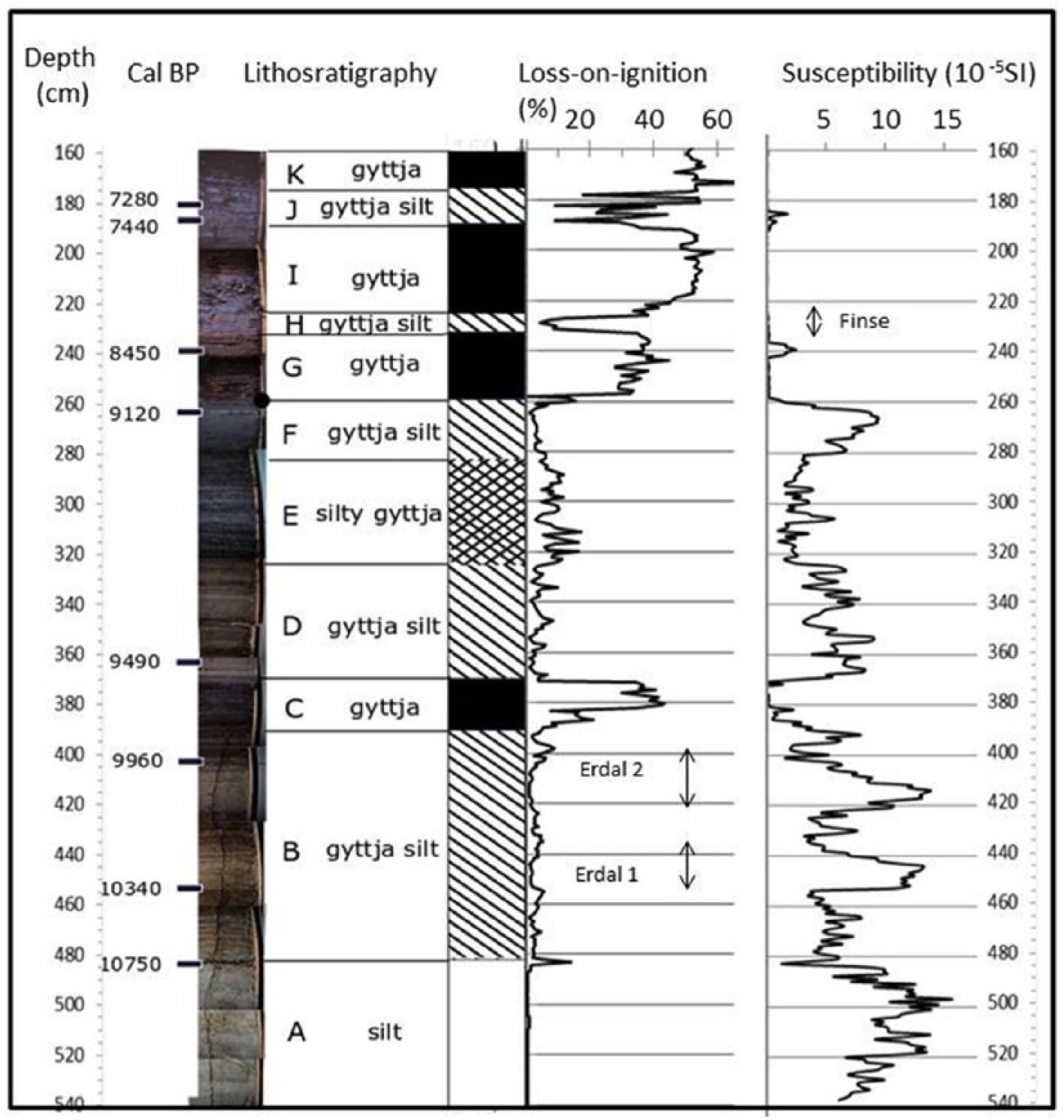
Lithostratigraphy, radiocarbon dates, loss-on-ignition and magnetic susceptibility in core 2.
Unit B (484–390 cm) starts with a 2-cm thick layer of dark brown gyttja, where LOI is high (13.8%) and MS is very low, 1.46 × 10⁻⁵ SI. The average values in unit B are 2.9% and 6.82 × 10⁻⁵ SI, respectively. From 482 to 464 cm, there are nine layers of silt alternating with gyttja silt. Between 465 and 442 cm, there is a homogeneous layer of silt with low LOI and correspondingly high MS. There is a similar layer of silt between 464 and 408 cm. Units A and B are separated by a sharp boundary.
Unit C (390–470 cm) consists of gyttja with a high LOI (25.9% on average) and a MS of 0.94 × 10⁻⁵ SI.
Unit D (370–325 cm) consists of alternating layers of gyttja and silt, with an average LOI of 3.4% and an average MS of 5.79 × 10⁻⁵ SI. At 348 and 335 cm, the LOI is 7% with correspondingly low values of MS. Between 360 and 370 cm, there is fine sand with a thin layer of clay in the middle of it.
Unit E (325–285 cm) has alternating layers of gyttja and silt. The average LOI is 8.5% and average MS is 2.60 × 10⁻⁵ SI.
Unit F (285–260 cm) consists of gyttja in the lower part and more silt in the upper part. The average LOI is 3.3% and average MS is 6.54 × 10⁻⁵ SI, increasing upwards.
Unit G (259–231 cm) consists of gyttja with an average LOI of 31.4% and an average MS of 2.45 × 10⁻⁵ SI. There are two silt layers in the upper part. The MS changes inversely with LOI.
Unit H (231–227 cm) is a silt layer with a low content of organic material. The average LOI is 8.3%. The average MS is also low in this layer, on average 0.15 × 10⁻⁵ SI.
Unit I (227–190 cm) is dark brown gyttja with high LOI values, on average 49.2%, and average MS is 0.11 × 10⁻⁵ SI.
Unit J (190–175 cm) has alternating layers of gyttja and silt, reflected by high-amplitude fluctuations in LOI. The average LOI is high, 36.6%, and MS is correspondingly low, on average 0.34 × 10⁻⁵ SI.
Unit K (190–160 cm) contains dark brown gyttja with an average LOI of 53.6% and low MS, average value 0.10 × 10⁻⁵ SI. The uppermost 160 cm of the core – not shown in Figure 4 – also consists of dark gyttja with some light brown layers.
MS decreases with increasing LOI (Figure 4). Seierstad et al. (2002) found a positive correlation between MS and fine to medium silt, and a negative correlation between fine sand to coarse silt. We have no grain size analyses, but visually coarse silt and fine sand seem to dominate in the uppermost minerogenic layers where MS is low.
Time resolution and sediment accumulation rate
Eight AMS radiocarbon datings were carried out on gyttja in core 2 from Dalevatnet (Table 1).
Age–depth relationship in the lake sediments has been inferred by linear interpolation between the eight calibrated ages (Table 1, Figure 6), and between the uppermost date and top of the core. The time resolution varies from 32 yr/cm at 181 to 186 cm to 3 yr/cm at 265 to 365 cm.
The accumulation rate (Table 2) varies from 0.52 mm/yr (186–239 cm) to 2.7 mm/yr (265–365 cm). Average time resolution is 17.6 yr/cm and accumulation rate is 0.98 mm/yr. The accumulation rate is highest in the middle of the core (350–250 cm) in the time span, ca. 9500 to 9200 cal. yr BP, where the sediments vary between silt and gyttja. This may be interpreted as a period when the glacier was retreating, perhaps combined with flood events.
Time resolution and sediment accumulation rate in core 2 Dalevatnet.
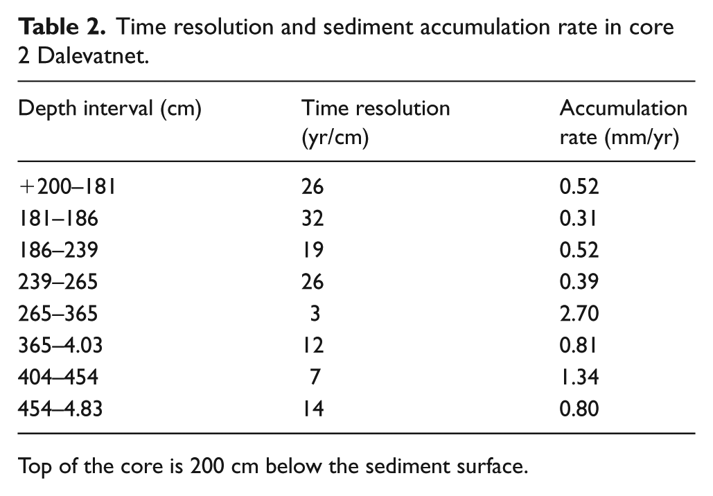
Top of the core is 200 cm below the sediment surface.
Early-Holocene glacier history of Grovabreen
LOI, MS and visual evaluation of the core were used to interpret glacial activity in the catchment area of Dalevatnet. The sediment yield in glacier-fed lakes is positively correlated with glacier size (Roland and Haakonsen, 1985). Silt layers in glacier-fed lakes are widely used as records of glacier advances (Bakke et al., 2005b).
The relative chronology of the marginal moraines was also evaluated using Schmidt-hammer exposure-age dating and lichenometry.
The lake sediments vary from clay and silt to fine sand, dark gyttja and some layers of light gyttja. At least three zones of fine silt with low LOI and high MS are interpreted to represent glacier events, which according to radiocarbon dating took place just before 10,750 cal. yr BP, between 10,340 and 9960 cal. yr BP, and from 8450 to 7280 cal. yr BP.
The lowermost silt, unit A, from 540 to 484 cm, represents glacial erosion in the catchment before the establishment of vegetation. The early-Holocene glacier activity terminated at ca. 10,800 cal. yr BP, where there is a distinct transition to unit B. The lowermost 3 cm in unit B consists of gyttja, apparently from the first vegetation that was established in the catchment. Alternating layers of silt and gyttja upwards indicate varying glacier activity, where readvances are accompanied by increased glacial erosion. From 482 to 465 cm, there are seven minerogenic bands with sharp boundaries, possibly representing short episodes of glacial activity which may correspond to Jondal Event 2, bracketed between 10,550 and 10,450 cal. yr BP (Bakke et al., 2005a). Then follows a 10-cm layer of gyttja (at 455 cm) deposited before 10,340 cal. yr BP.
Low LOI and correspondingly high MS values at 455 to 440 cm indicate increased glacial activity from 10,340 cal. yr BP and can be correlated with the Erdalen Event (Figure 5; Bakke et al., 2005a; Dahl et al., 2002; Nesje et al., 1991, 2005). In Jarbuvatnet, the Erdalen Event is dated to 10,295 to 9910 cal. yr BP. Another minerogenic layer (420–410 cm) with low LOI and high MS values is dated to before 9960 cal. yr BP, which is within the previously reported interval for the Erdalen Event, 10,100 to 9700 cal. yr BP (Dahl et al., 2002). The Erdalen Event is recorded in front of outlet glaciers of Jostedalsbreen as two prominent terminal moraines (Nesje et al., 2001, 2006).

The lower part of the core showing silt layers dated to Erdalen Events 1 and 2.
These terminal moraines may be correlated with the outermost largest terminal moraine, M1, in Fagredalen (Figure 2).
A gyttja layer in unit C, 390 to 370 cm, above the Erdalen Event sediments, indicates glacier retreat in the catchment. This unit has the highest LOI values in the lower part of the core. From 9490 to 9120 cal. yr BP, the sediments show alternating gyttja and silt layers, indicating a number of glacial advances and retreats. In unit F, LOI decreases to nearly zero, and the MS increases, indicating glacial activity shortly before 9120 cal. yr BP.
However, there is another possibility that cannot be excluded. Some of the thin minerogenic layers and the 10-cm thick sand layer at 360 to 370 cm may represent flood events, especially the sediment sequence deposited between 9490 and 9120 cal. yr BP, a period of high precipitation. This sequence has the highest sedimentation rate, 2.70 mm/yr, and mostly low organic content (Figure 6).
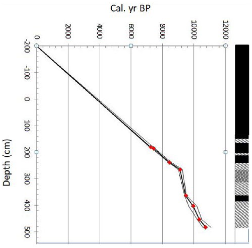
Age–depth relationship with 2 standard deviations, based on eight AMS radiocarbon dates from core 2. Top of the core is 200 cm below lake bottom (see Table 2).
From units F to G, there is a marked increase in LOI together with a decrease in MS. Gyttja dominates in unit G, indicating the presence of established forest vegetation.
Unit H is a silt layer with a marked decrease in LOI. The unit is a little younger than 8450 cal. yr BP and may be correlated with the Finse Event between 8500 and 8200 cal. yr BP.
The overlying unit I (225–190 cm) consists of dark brown gyttja with still higher organic content than unit G, signifying dense forest vegetation in the area and Holocene climate optimum.
Unit J (190–175 cm) is gyttja silt dated between 7440 and 7280 cal. yr BP. A two-peaked decrease in LOI is probably caused by glacial advances. Thereafter, the glacier seems to have retreated, as only gyttja is found further upwards in the lake sediments. Nesje (2009) also reported two minor advances of Jostedalsbreen at 7700 and 7400 cal. yr BP, after which the ice cap melted away.
Discussion
The deglaciation in the Dalevatnet area is dated to 10,750 cal. yr BP, about 1300 cal. yr earlier than the deglaciation of Grøningstølsvatnet south of Grovabreen. This may be because Grøningstølsvatnet is closer to the glacier, and because of the higher elevation of Haukedalen and the surrounding mountains. Apparently, Grøningstølsvatnet was ice-covered during the Erdalen Event.
The outermost and largest marginal moraine of the early Holocene, M1, can be traced almost continuously along the entire northern margin of Grovabreen. Lichen thalli (Rhizocarpon geographicum) with a diameter of more than 30 cm have been measured on the moraine ridges here. There are 1 to 2 m thick peat deposits in river sections, and ‘old vegetation’ is found both distally and proximal to the moraine ridges. Schmidt-hammer age evaluation indicates that the outermost marginal moraines M1 and M2 (Figure 7) are from the early Holocene. The slightly lower rebound value on M2 than M1 is probably due to a measuring error.
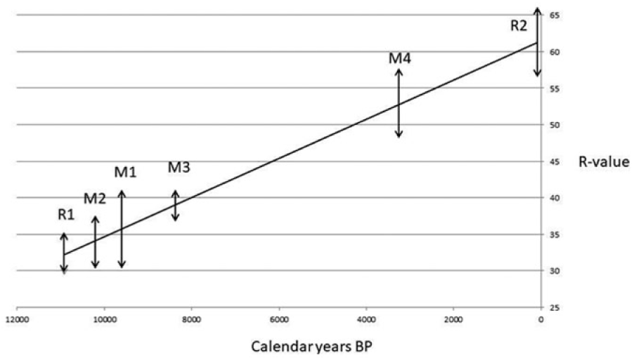
Age estimates for moraines M1, M2 and M3 in Fagredalen based on sites of ‘known’ age: R1, the rock surface on the 800-m high mountain ridge NE of Dvergsdalsdalen, deglaciated at about 11,000 cal. yr BP, and R2, fresh boulders near the newly built hydropower dam in Fagredalen.
A silt layer (450–440 cm) in unit B is presumed to reflect increased glacial activity soon after 10,340 cal. yr BP. Another silt layer (420–400 cm) was deposited just prior to 9960 cal. yr BP. These silt layers probably correspond with the marginal moraines M1 and M2, and their age as determined corresponds to the two-peaked Erdalen Event.
The Erdalen Event is recorded as prominent marginal moraine ridges in front of many outlet glaciers from the Jostedalsbreen ice cap, dated to 10,295 to 9910 cal. yr BP (Nesje et al., 2001). These moraines have been dated stratigraphically in front of Nigardsbreen to ca. 10,100 to 9700 cal. yr BP (Dahl et al., 2002). Schmidt-hammer dating at Bøyabreen indicated that the outermost large terminal moraine is from the early Holocene (Aa and Sjåstad, 2000).
The Erdalen Event has been recorded as gyttja silt in lacustrine sediments deposited from a cirque glacier in Sunnmøre, in which maximum and minimum radiocarbon dates were found to be 9460 ± 180 and 9060 ± 190 14C yr BP (Eikeland, 1991). At Hardangerjøkulen, Nesje and Dahl (1991) dated a glacier fluctuation of Blåisen to ca. 10,100 cal. yr BP (Nesje, 2009). At Nordre Folgefonna, the Erdalen Event 1 is connected with a TP-ELA depression of 210 m primarily due to increased winter precipitation (Bakke et al., 2005a). Bakke et al. (2013) examined three cores from Sørsendalvatn, 20 km NW of Grovabreen. Based on dry bulk density variability, they concluded that the oldest moraine was probably linked to the glacier advance of the Erdalen Event, dated to 10,300 to 9700 cal. yr BP (Nesje, 2009; Nesje et al., 1991).
From 9490 to 9120 cal. yr BP, there appear to have been a number of glacier oscillations in Fagredalen.
Distinct silt layers a little younger than 8450 cal. yr BP may correspond to the marginal moraine M3 (Figures 1 and 2) in Fagredalen, and the age determination corresponds well with the Finse Event, whose maxima are dated between 8500 and 8200 cal. yr BP. The Schmidt-hammer test indicated that moraine M3 is significantly younger than M1 and M2 but also from the early Holocene.
Climatic deterioration around 8400 to 8000 cal. yr BP was first reported from northern Sweden (Karlén, 1976). Dahl and Nesje (1994, 1996) and Nesje and Dahl (2001) showed that Hardangerjøkulen readvanced around 8200 cal. BP. A core from Jarbuvatnet at Flatebreen, a part of Myklebustbreen, revealed a glacial episode from 8400 to 8100 cal. yr BP (Nesje et al., 2001), and a core from Grøningstølsvatnet (Seierstad et al., 2002), where there was a reduction in LOI values between 8420 and 7880 cal. yr BP, were interpreted to represent the 8200 cal. yr BP event.
In Sørsendalen, Bakke et al. (2013) dated the maximum glacier extension during the Finse Event to between 8280 and 8060 cal. yr BP. The strong increase in glacial activity started at 8390 cal. yr BP, as compared with ca. 8450 cal. yr BP at Grovabreen. Minimum glacier extension in the early Holocene in Sørsendalen was recorded around 9000 cal. yr BP, which may correlate with the 20-cm thick gyttja layer in Dalevatnet that was dated to 9120 cal. yr BP.
No marginal moraines recording the Finse Event have been found in Western Norway previously. However, in Fagredalen, the LIA glacier advance seems to have been rather short. If we assume that the glacier extension prior to the LIA was the same as today, the advance was about 2 km on the southern side, but less than 500 m on the northern side (Figure 8). The corresponding figures for vertical lowering were ca. 500 and 200 m (Figure 8). These figures may be explained by topographic differences, since there is a glacial cirque and valley step on the northern side, in contrast to the more gradual sloping valley bottom on the southern side. In addition, 2.42 km2 of the glacier drains southwards and only 0.9 km2 drains northwards (Østrem et al., 1988).
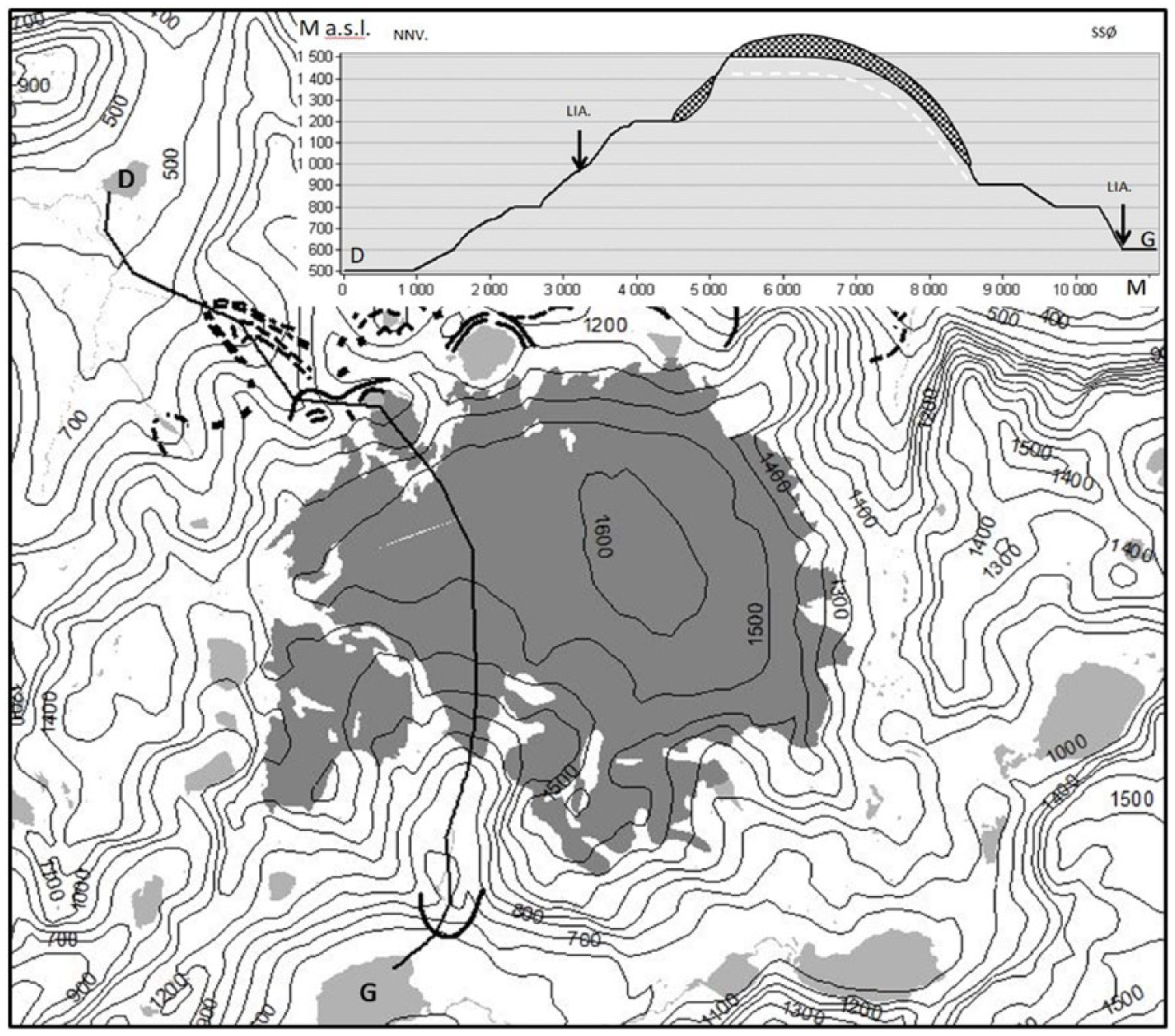
Map and cross-section through Grovabreen. The maximum advances of LIA glaciers are shown by arrows. D: Dalevatnet; G: Grøningstølsvatnet.
The AAR-ELA depression at the LIA maximum was 145 m on the southern side of Grovabreen, compared with 115 m at Vidunderdalsvatnet close to Fagredalen on the eastern side (Aa, 1996). These findings support the conclusion that the maximum advance of the Fagredalen glacier during the LIA was short and that it did not reach the presumed Finse Event moraine.
Bakke et al. (2005a) have recorded two early-Holocene glacial events predating the Erdal Event, the Jondal 1 (11,100 cal. yr BP) and Jondal 2 (10,550–10,450 cal. yr BP) Events, and an alternative morphostratigraphical correlation could therefore be that M1 reflects Jondal Event 1, M2 is a rather young Jondal Event 2 moraine, and M3 could belong to the Erdal Event 2. However, the Jondal Event 1 is too long ago. At that time, the Dalevatnet area was still ice-covered. This interpretation also implies a very short time span between M2 and M3, whereas Schmidt-hammer measurements show that they are separated by more than 1000 years.
Ice core data from Greenland and from European lake sequences demonstrate that the 8200 cal. yr BP event influenced the entire Northern Hemisphere (Alley et al., 1997; Dansgaard et al., 1993; Nesje and Dahl, 2001). The reason for this climatic deterioration has been identified as the influence of meltwater on the thermohaline circulation during the deglaciation of the Laurentide ice sheet (Kerwin, 1996; Klitgaard-Kristensen et al., 1998).
No datings have been obtained in the Dalevatnet lake sediments from the mid- or late Holocene. The upper part of the core is homogeneous gyttja. The reason for the lack of minerogenic sediments is probably that the Fagredalen river no longer drained into Dalevatnet or that the glacier melted away.
Conclusion
Quaternary geological mapping in the Grovabreen area, Schmidt-hammer exposure-age dating, and coring in Dalevatnet in Dvergsdalsdalen to the northwest of the glacier have given the following results concerning the early-Holocene history of the glacier:
The deglaciation is dated to 10,750 cal. yr BP at the transition from minerogenic to organic sediments in Dalevatnet. Thereafter, the lake deposits show alternating layers of organic and minerogenic sediments. From 9120 cal. yr BP to the top of the core, the sediments are mainly gyttja, with the exception of the gyttja silt unit dated as younger than 8450 cal. yr BP.
Two large marginal moraines, M1 and M2, in the mouth of Fagredalen and along the northern margin of Grovabreen, are correlated with two silt layers that have been detected through low LOI values and high MS in the Dalevatnet core. These layers are radiocarbon-dated to between 10,340 and 9960 cal. yr BP. This corresponds to datings of the Erdalen Event moraines that have been reported from northern Folgefonna, Hardangerjøkulen, Jotunheimen and in front of several outlets around Jostedalsbreen, commonly about 1 km beyond the LIA moraines, as in Fagredalen.
Thin silt layers in the core from 225 to 230 cm are dated to somewhat younger than 8450 cal. yr BP. The marginal moraine M3 in Fagredalen is interpreted to be connected with these silt layers. This age determination corresponds to the Finse Event, which has been recorded by stratigraphical and sedimentological methods downstream of present glaciers and in Greenland ice cores. Because glacier extension was greater during the LIA than during the Finse Event, moraines from the latter are usually absent. However, in Fagredalen, there seems to have been an unusually short maximum glacier advance during the LIA, mainly due to the topography of the area, and the Finse marginal moraine appears to have been preserved. This is also supported by Schmidt-hammer exposure-age dating on the moraine ridge.
LIA marginal moraines with lichen thalli ⩽10 cm have been found at 1000 m in Fagredalen and around most of Grovabreen. At Vidunderdalsvatnet, 8 to 10 younger terminal moraines have been mapped.
Footnotes
Acknowledgements
We would like to thank the two referees, whose comments have greatly improved the manuscript, and Alison Coulthard for linguistic review. We are also grateful to everyone else who has provided assistance.
Funding
The study was financially supported by Kjøsnesfjorden Kraftverk. The MS measurements were carried out in Reidar Løvlie’s laboratory at the University of Bergen, and the loss-on-ignition analyses were made in the Geological Laboratory at Sogn og Fjordane University College by Leiv Inge Aa.