
Abstract
As part of the Changing the Face of the Mediterranean Project, we consider how human pressure and concomitant erosion has affected a range of Mediterranean landscapes between the Neolithic and, in some cases, the post-medieval period. Part of this assessment comprises an investigation of relationships among palaeodemographic data, evidence for vegetation change and some consideration of rapid climate change events. The erosion data include recent or hitherto unpublished work from the authors. Where possible, we consider summed probabilities of 14C dates as well as the first published synthesis of all known optically stimulated luminescence dated sequences. The results suggest that while there were some periods when erosion took place contemporaneously across a number of regions, possibly induced by climate changes, more often than not, we see a complex and heterogeneous interplay of demographic and environmental changes that result in a mixed pattern of erosional activity across the Mediterranean.
Introduction
Ever since humans started to have an impact on vegetation cover through agricultural and/or fire-setting activities, the rates at which landscapes erode have increased significantly (Montgomery, 2007). In many regions around the world that face or have faced anthropogenic accelerated erosion, this process has been linked with a decline in agricultural productivity to unsustainable levels, and even societal collapse (Diamond, 2005; Montgomery, 2007). As has been argued by researchers for several decades, this is all the more true for large parts of the Mediterranean, a region that has experienced significant human impact for several millennia, leading to landscape degradation through soil erosion (Lowdermilk, 1953). However, this viewpoint on the linkage between anthropogenic induced land degradation and collapse has also been challenged. First, resilient societies are thought to have adopted new strategies to cope with these environmental changes (Costanza, 2012; Grove and Rackham, 2001; Walsh, 2013). Second, the relative importance of the role of humans in controlling soil erosion compared to natural drivers of erosion, such as climate change, has been debated as well. Within his pioneer study on Mediterranean erosion, Vita-Finzi (1969) established a broad chronological framework with two significant phases of erosion, one dated to the Upper Palaeolithic, and the second dated to the Historic Period. Vita-Finzi (1995) stressed the importance of climate in controlling historical alluvial sedimentation. Van Andel and others have challenged this hypothesis, pointing towards the dominant role humans have exerted on sediment fluxes in antique Greece (Van Andel et al., 1986; Van Andel and Zangger, 1990). In more recent years, some have questioned these often-simplistic mono-causation models (Bintliff, 2002). Indeed, recent reviews of historic erosion and sedimentation for several parts of the Mediterranean have argued that there are periods when human impact can be identified from sediment records, however, the role of climate cannot be neglected either for other moments in the past, especially when regional scales are considered (Bellin et al., 2013; Dusar et al., 2011; Faust and Wolf, 2017. Large-scale phases of Rapid Climate Changes (RCCs) suggested by Mayewski et al. (2004), that is, periods when there are relatively significant changes in temperature and humidity, have been extensively discussed in relation to erosion in a Mediterranean context (e.g. Bintliff, 1992; Casana, 2008; Fletcher and Zielhofer, 2013; Macklin et al., 2015). Disentangling climatically caused erosion periods from erosion caused by human activity, however, is not straightforward since these two controlling factors are often coupled and increased sediment dynamics can only be explained through an interplay between both controlling factors (e.g. Fuchs, 2007).
We are fully aware that meta-analyses, such as those presented here, do not necessarily engage with the complexity of the many spatial and temporal scales over which human–environment interactions operate. This is especially true when assessing sedimentation, which reflects a wide range of processes and scales across any given catchment or drainage basin (Macklin et al., 2015; Vanmaercke et al., 2015; Verstraeten, 2015). Therefore, we aim to provide a synthesis and assessment that can be tested in the future against other data that operate at sub-regional and local scales. In order to resolve how past Mediterranean societies impacted geomorphic systems, it has been suggested that there is a need for more detailed and quantitative reconstruction of the palaeo-vegetation, demographic and geomorphic records, particularly at the regional scale (de Vente et al., 2014; Dusar et al., 2011). Within this study, we address this complex issue of how Mediterranean societies have influenced geomorphic systems through the assessment of the relationship between demographic indices, palaeoecological data indicative of agricultural activity, and erosion data. This contribution is part of the Changing the Face of the Mediterranean Project, which has investigated human–environment interactions across the Mediterranean environments from the Neolithic to the Medieval and post Medieval periods (Figure 1). The broader project employs new models of demographic change, based on site data derived from many different published sources, along with the modelling of radiocarbon dates. We compare these data with the palaeoecological data, derived from almost all available pollen diagrams from five case study areas (within Turkey, Greece, Italy, South of France and Spain) presented within this special issue. This paper focusses on sedimentation data, comparing this, in the discussion section, with demographic and palaeoecological information. While the palynological and archaeological data lend themselves to continuous, diachronic profiling and modelling, geoarchaeological and geomorphological data rarely possess the temporal resolution or precision possessed by these other data, although, where possible, we have included existing summed probabilities of radiocarbon dates from across the region.
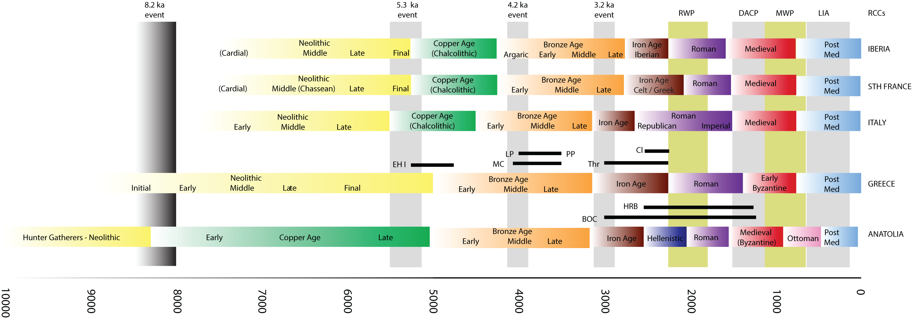
The archaeological chronological periods referred to in the text along with key climate phases, including Rapid Climate Change ‘events’.
Methods
This paper presents a combination of region-specific geoarchaeological case studies, many of which have been carried out by the authors of this paper. The study regions presented here run broadly from east to west, that is, from Anatolia and Greece to Italy, the south of France, and ending with Spain (Figure 2). Our fundamental aim is to assess the relationships between demographic data, the nature of human activities and their impact on the environment, as well as how these processes intersect with climate change. The geomorphic data are derived from alluvial, colluvial and lacustrine records spread across a range of landscape types, that is, from hillslope records to river systems and coastal areas. We specifically address these various landscape settings, as it is impossible to define one isolated relationship between erosion histories and sediment stratigraphy for a given type of sediment record. Indeed, many studies have shown that colluvial, alluvial, lacustrine and coastal records all respond differently to human-induced erosion depending on the timing, duration, intensity and spatial extent of human impact (Dusar et al., 2011; Fryirs, 2013; Houben et al., 2013; Verstraeten et al., 2017; Zolitschka et al., 2003). A critical comparison of how the various sedimentary environments responded to changes in demography, anthropogenic land cover and/or climate change may include therefore valuable information on the complexity of past human–environment interactions.
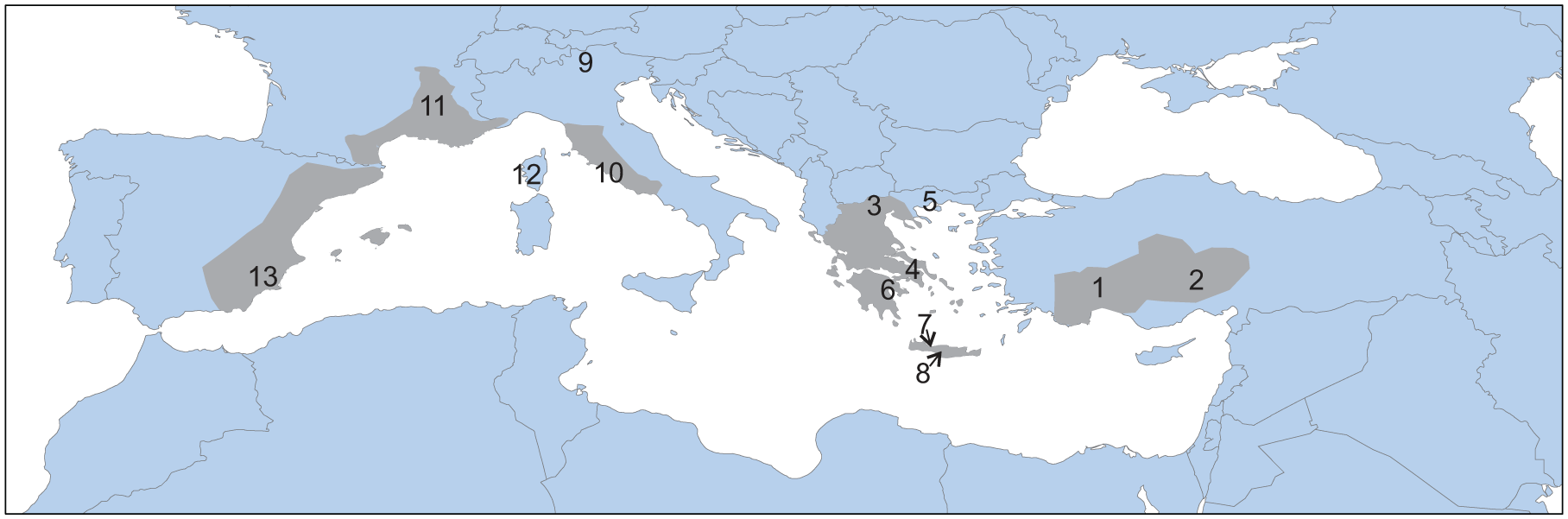
Grey shaded areas–study areas with demographic, geomorphological and palynological data. Numbers refer to sites with erosion records referred to in text: 1 – Nar Lake (Turkey); 2 – Sagalassos (Turkey); 3 – Aliakmon-Axios deltas (Nth Greece); 4 – Chiklis, 5 – Angitis River and Dikili Tash (Nth Greece); 6 – Philious Basin (Sth Greece); 7 – Lake Kournas (Crete); 8 – Messara Plain (Crete); 9 – Lake Ledro (Italy); 10 – Turano Basin, Fiora, Marta and Treia rivers and Lago Lungo (Italy); 11 – Rhone Valley (France), 12 – Taravo River (Corsica), Sagone River (Corsica); 13 – Lorca alluvial fan, Librilla ‘Rambla’ (Spain).
The case studies below unsurprisingly rely on 14C dates; however, this paper also includes the first comprehensive meta-analysis of optically stimulated luminescence (hereinafter OSL) dates from across the Mediterranean.
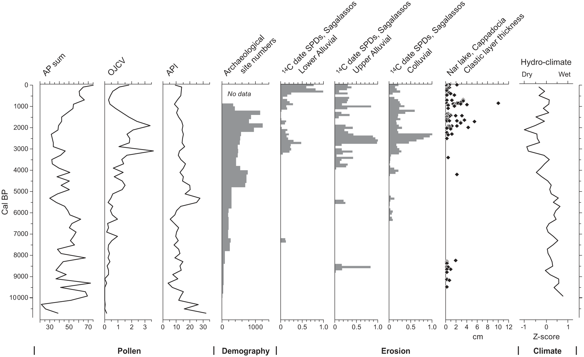
Traditionally, rates of erosion and sedimentation, as well as the frequency of erosion/sedimentation events, have been established using radiocarbon dating of plant macrofossils or charcoal preserved in sediment archives (Brown, 1997, 1999). However, while this has been successful in temperate Europe and elsewhere, it can be far more problematic in the Mediterranean. This is primarily due to the lack of suitable organic matter within alluvial and colluvial sequences due to the semi-arid climate (in parts of the Mediterranean) and the deep penetration by roots of phreatophyte trees and shrubs. Furthermore, both charred and uncharred macrofossils may be reworked. A good example is the dating of alluvial fills in Malta, where nearly 90% of radiocarbon AMS dates were in error, with numerous time reversals and common age inversion in the late Holocene. More subtly, these problems also impose a potential bias on sampling as it is increasingly unlikely that suitable material will occur higher up the sedimentary sequence and for the last two centuries radiocarbon dates also suffer from the De Vries effect. This is also reflected in the demographic proxy records presented in this paper for Turkey (Figure 3), Italy (Figure 7) and Spain (Figure 9) which lack enough dates over the last 2000 years for SPD analysis. However, suitable material can sometimes be found, and analysis of AMS dates for flood units does exist for regions such as Spain (Thorndycraft and Benito, 2006).
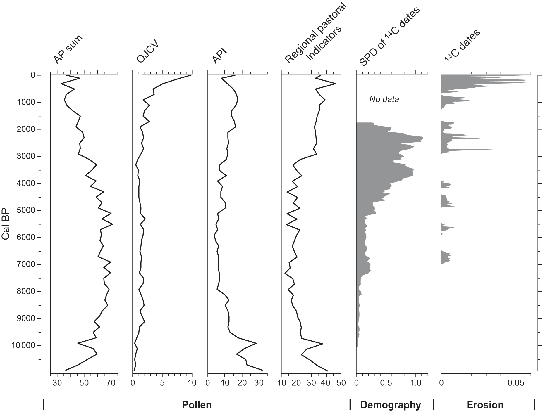
S Turkey: pollen indicator groups, archaeological site survey (grey), erosion and hydro-climate data (Dusar et al., 2012); Finné et al., 2019; Roberts et al., 2019; Woodbridge et al., 2019. Note the increase in olive production prior to the onset of the main erosion event, and demographic indices increase just after.
There are now several alternatives to 14C, including OSL, which due to high insolation should theoretically be more suited to the Mediterranean than northern Europe, as well as palaeomagnetic dating and most recently cosmogenic burial dating (Granger and Muzikar, 2001). Palaeomagnetic dating has been used in Central Italy (Ellis and Brown, 1999) and the Central Medjerda basin, Tunisia (Faust et al., 2004). Cosmogenic dating has so far only been used for dating Pleistocene terraces (Rixhon et al., 2011). In order to counteract the bias in the 14C record, an OSL dataset is presented in this paper. This has been derived from 17 regional studies using predominantly quartz luminescence, but in some cases infra-red luminescence of feldspar (Figure 10). All studies involved the etching of grains, used Rizø OSL counters and followed internationally accepted protocols and multiple aliquot methods. It is expected that the largest source of inter-laboratory variance is probably the estimates of dosimeter but that this should vary less than 15% (Hilgers et al., 2001) Given the uncertainties of the method an uncertainty of at least 10–15% must be assumed. Also given the relatively low number of OSL dates available (139 in this study), the data are described and discussed in one dedicated section rather than distributed across the individual regional sections.
The discussion section incorporates meta-analyses of demographic proxies and pollen-count data. Demographic proxies have been derived from archaeological data (radiocarbon dates and settlement data) either harmonized from online sources and existing databases (e.g. BANADORA, RADON, University of Oxford’s ORAU, EUROEVOL’s project) or, manually inputted from a wide range of publications. The probabilities from each calibrated date are combined to produce a summed probability distribution (SPD). Following previous works (Weninger and Harper, 2015; Williams, 2012) showing that normalized calibrated dates emphasize narrow artificial peaks in SPDs due to abrupt peaks of the radiocarbon calibration curve, we opted to use non-normalized dates prior to summation and calibrated via IntCal13 curve (see Palmisano et al., 2017; Roberts et al., 2018). Two different proxies derived from archaeological settlement data have been used to assess demographic trends over the long run: raw site counts and summed settlement area. To address issues related to the temporal uncertainty of occupation periods, we adopted ‘aoristic’, and Monte Carlo approaches (for a more detailed explanation of the methodology see Palmisano et al., 2017). We present a brief synthesis of key demographic trends for each region, while the detail is contained in the region-specific papers in this special issue.
We obtained pollen count data from the European modern (Davis et al., 2013; Fyfe et al., 2018; Palmisano et al., 2017; Woodbridge et al., 2018) and fossil pollen databases (EPD version: Oct. 2017) (Leydet, 2007–2017). Descriptions of the methodological approaches developed and applied to the pollen datasets are provided in Woodbridge et al. (2018) and Fyfe et al. (2018). The pollen count data from each site were summed into 200-year time windows and analyses were applied to the entire Mediterranean region in order to identify key vegetation types (Giesecke et al., 2014). Pollen indicator groups were used to summarize key changes in the datasets. This included calculating the average arboreal pollen sum (%AP), a sum of tree crop indicators OJC (Olea, Juglans, Castanea) (Mercuri et al., 2013a) (also combined with Vitis), calculation on an anthropogenic pollen index (API: Artemisia, Centaurea, cichorieae and Plantago, cereals, Urtica and Trifolium type) (Mercuri et al., 2013b), and a sum of pastoral indicators (Asteroideae, Cichorioideae, Cirsium-type, Galium-type, Ranunculaceae and Potentilla-type pollen) (Mazier et al., 2006).
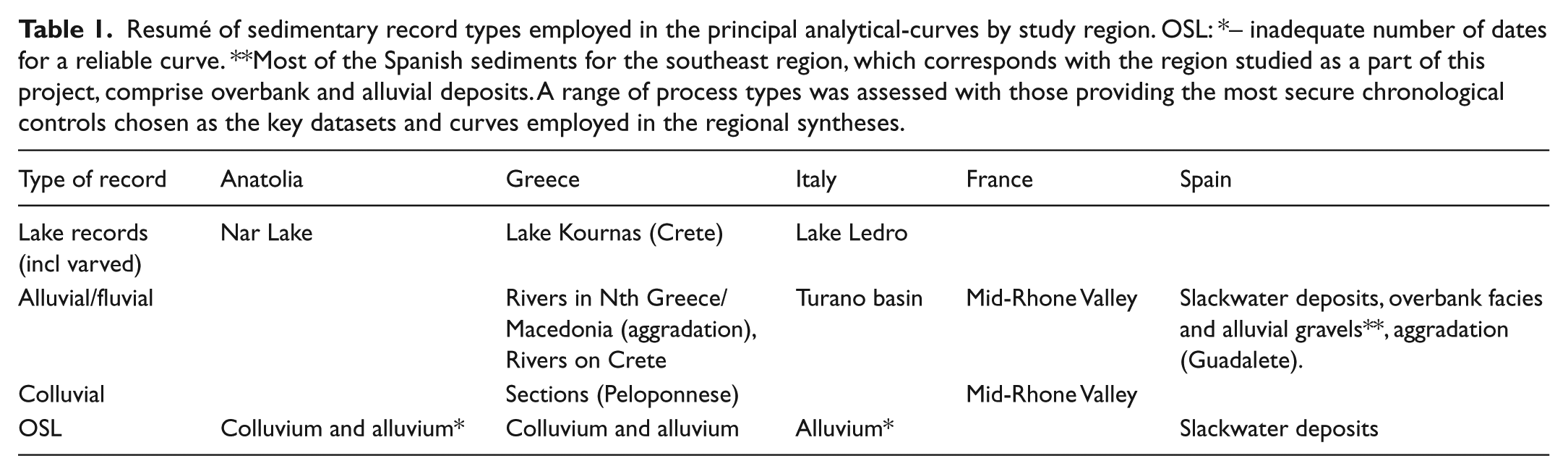
Much of the geomorphic evidence presented below is derived from studies of alluvial/fluvial deposits and the dates assigned to phases of flooding, which might include overbank deposits and/or fluvio-torrential units (see Table 1 for record types). We also refer to alluvial/fluvial units deposited in coastal zones that result in progradation or aggradation of the coastline. More than other environments, late-Holocene Mediterranean coastal areas have evolved through an interplay of natural and anthropogenic factors (Anthony et al., 2014; Arnaud-Fassetta, 2002; Marriner and Morhange, 2007). Sometimes lagged responses of river systems in lower or coastal plains mark the delay of the stony load from the head of the watershed, which further complicates the search for causalities. Some lake-based studies are considered, in particular, the work in Anatolia where clastic units have been trapped in between the laminated sediments of Nar Lake. Finally, some examples of geoarchaeological work on colluvial units and soil erosion are presented, the most notable example of this being Fuchs’ work in the northeast Peloponnese and Notebaert and Berger in the Middle Rhone Valley (Fuchs, 2007; Notebaert and Berger, 2014).
Resumé of sedimentary record types employed in the principal analytical-curves by study region. OSL: *– inadequate number of dates for a reliable curve. **Most of the Spanish sediments for the southeast region, which corresponds with the region studied as a part of this project, comprise overbank and alluvial deposits. A range of process types was assessed with those providing the most secure chronological controls chosen as the key datasets and curves employed in the regional syntheses.
Examples by country/region
Anatolia
Coastal
There are very few studies of coastal and delta progradation on the south coast of Anatolia, with most research having focussed on the rivers that enter the western Anatolian (Aegean Sea) coast. Here some major archaeological sites, such as Troy and Ephesus, are now located inland, but originally lay on, or very close to, the coastline (Brückner et al., 2005; Kayan, 1999). The Classical city of Miletus, for example, initially lay at the mouth of the Meander river, (Brückner et al., 2006, 2017), but this has pushed its mouth seawards in recent millennia. Although delta progradation can be partly explained through natural long-term geomorphological dynamics (including sea-level change impacting on accommodation space), evidence suggests that the rate of progradation has accelerated since the 1st millennium BC as a consequence of human-induced increases in erosion and sediment discharge (Lambrianides and Spencer, 1998). The interaction between naturally varying rates of progradation, such as the mid-Holocene slowdown in relative sea level rise (the ‘Stanley effect’ cf. Stanley and Warne, 1997) is geographically unique due to isostatic, geomorphic (including soil) and local population history, but it can have important human implications (see discussion).
Lake records
Within lakes, gross lake sedimentation rate data may not accurately reflect flux rates from catchment erosion. A good example is provided by Nar Lake, a small volcanic maar in Cappadocia, central Anatolia. Most of the Nar lake sediments are annually laminated, allowing rather precise chronological resolution, but these varves are comprised primarily of endogenic carbonate, organic matter and diatoms, with only a minor detrital component. Hence, overall sedimentation rate changes do not reflect catchment erosion very strongly. Interbedded between regular varves at Nar Lake are periodic clastic layers, interpreted as turbidites for the most part. Visual recording, Itrax elemental chemistry and thin section analysis show that these clastic layers were rare before the late Holocene (Figure 3). On the other hand, after 2600 BP, there are numerous inwash layers, notably during times when pollen data indicate land-use intensification (Roberts et al., 2019).
Alluvial and colluvial slope fills
There have been many geoarchaeological and geomorphological studies of Holocene alluvial and colluvial sediments in southern Anatolia (e.g. Boyer et al., 2006; Dreibrodt et al., 2014). Some of the most detailed studies have taken place linked to archaeological studies in the territory of the ancient city of Sagalassos, and which are also linked to pollen studies in the same area (e.g. Bakker et al., 2012). Dating of basin fill and fluvial sequences by 178 radiocarbon ages for geomorphological activity and their analysis using summed probability distributions shows overall low rates of sediment flux before the late Holocene (Dusar et al., 2012). This changed dramatically at 2800–2400 BP when a significant pulse of colluvial inwash entered some basins (e.g. Gravgaz) from surrounding hard limestone hillslopes. At the same time, pollen data indicate the first large-scale woodland clearance followed after ~2400 BP by the cultivation of tree crops and cereals, marking the onset of the so-called Beyşehir Occupation phase in this area (Figure 3). The increased sedimentation rates coincided with the initial significant anthropogenic disturbance of the landscape, and sediment accumulation decreased afterwards, mainly as a result of the depletion of hillslope sediment sources (Van Loo et al., 2017). Sedimentation rates during the most prominent occupation of the area, that is, during Roman Imperial times, were consequently much lower. By contrast, downstream river floodplain sedimentation has been substantial up until recent times, indicating not only a significant time lag in sediment delivery to the lower reaches of the river valleys but also significant reworking of previously deposited fluvial sediment (Verstraeten et al., 2017).
Short resumé of demographic trends
The first increase in human activity (as represented by the SPD of radiocarbon dates) took place in south-central Anatolia at ~10,300 BP (Roberts et al., 2018). This phase of Neolithic population growth ended after ~7500 BP. A more substantial demographic increase, as represented by raw counts and total areas of sites, occurred at 5000 BP during the early Bronze Age, from this point, the randomized duration index also increases (Figure 3). Then the Hellenistic-Roman-early Byzantine (H-R-B) phase, centred on 2000 BP is characterized by a significant increase in population, followed by a dramatic decrease just after 1500 BP.
Greece
A synthesis of OSL and 14C dates from the Eastern Mediterranean (Jones et al., 2015) reveals interesting patterns. Most of the dated fluvial and colluvial records in this Eastern Mediterranean dataset are from Crete or southern mainland Greece, so it is appropriate to compare them with the land cover and demographics from this region (Figures 4 and 5 and the Discussion section).
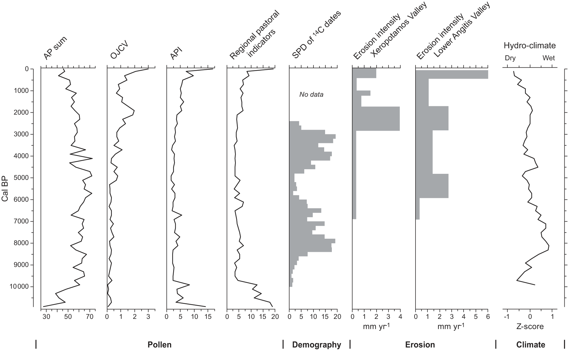
Northern Greece pollen indicator groups, archaeological site survey (grey), erosion (Glais et al., 2016; Lespez and Glais, 2017; Weiberg et al., 2019) and hydro-climate data (Finné et al., 2019). Of particular interest is the Iron Age (‘Thracian’ phase of erosion) that broadly coincides with the increase in the Olive, Juglans, Castanea and Vitis curve and the start of the increase in pastoral indicators.

Southern Greece (Peloponnese and Crete) pollen indicator groups, archaeological site survey (A – SPD of radiocarbon dates, B – raw count of sites (light grey = all possible sites, dark grey definite sites), C – Peloponnese sites count). OSL dates from colluvium Peloponnese (Fuchs, 2007); relative CDP plots of geochronological dates from floods and extreme fluvial event units of eastern Mediterranean rivers (Benito et al., 2015); and flood-events, Lake Kournas, Crete (Vanniere et al. unpublished data).
Coastal
The Greek mainland shoreline has been intensively investigated over the last five decades with a view to reconstructing shoreline migration and human activity during the Holocene (Runnels et al., 2005; Tourloukis and Karkanas, 2012). Records from some deltaic plains and lagoons indicate a detrital input dated from ~5500 BP, part of the early phase of delta development in the Eastern Mediterranean and Greece, however, climate controlled detrital inputs are observed earlier (Brückner et al., 2005; Psomiadis et al., 2014; Styllas and Ghilardi, 2017). The rhythms of delta progradation linked to major alluvial phases are spatially varied due to local socio-cultural contexts and variability in regional climate, latitude, type of relief and exposure of oceanic currents.
On the Thessaloniki (or Macedonian) plain, the Neolithic site of Nea Nikomedeia, now located ~30 km inland, would have been located on the edge of an embayment at the beginning of the 7th millennium BP. During the late Neolithic (6300–5900 BP) and Bronze Age (5000–3050 BP), there were phases of significant alluviation, which broadly correspond with regional erosion signals (Benito et al., 2015; Jones et al., 2015). Recent research (Styllas and Ghilardi, 2017) reveals how the early development of the Aliakmon-Axios deltas also took place during the late Neolithic 6100–5400 BP/4100–3400 cal. BP (Ghilardi et al., 2008a, 2008b, 2010). The second phase of important alluvial deposition is dated to 4200–3750 BP. A similar phase of Bronze Age (early Helladic) erosion has also been identified on Euboea (around Chalkis to Amarynthos). This was followed by delta development during the Geometric period when urban centres flourished. Finally, the last major phase of delta development occurred from the Classical period until the late Byzantine period.
Alluvial
Although just to the east of the zone for which we have demographic data, recent work in Eastern Macedonia and Thrace reveals evidence for localized anthropogenic soil erosion from the early Neolithic period (~8000 BP) at the bottom of the Dikili Tash site (Glais et al., 2016; Lespez and Glais, 2017). Soil erosion was far more significant during the Thracian period (Iron Age to Classical Greek period in southern Hellenic areas) and into the Roman period (Lespez, 2003, 2008). The impact of Thracian (~2400 BP) settlement has often been underestimated, but it is now apparent that it played an important role, with the extension and intensification of farming and grazing, as seen in the pollen data for this region (Figure 4). Interestingly, this phase of erosion does not appear in the Eastern Mediterranean regional record (Jones et al., 2015). The second period of soil erosion and alluvial aggradation took place during the Ottoman period, linked to the intensification of farming in the plain and the valleys, along with the increase of grazing in the surrounding mountainous areas (Lespez, 2003). Therefore, we are sure that erosion in these small river basins in Northern Greece was triggered by local human activities and exacerbated by meteorological events, especially storms and their associated flash floods (Glais et al., 2016, 2017; Lespez, 2007).
Along the Angitis River, which drains the Philippes-Drama plain, alluvial aggradation accelerated early on; a significant alluvial event is recorded in the Lower Valley just after 6000 BP (Figure 4), this may well have partly been caused by climate changes between 6500–5000 BP (Lespez et al., 2016). Some other short phases of alluvial aggradation, such as that along the Xeropotamos, might be explained by an increase in flood flows corresponding to wetter periods recorded at the global scale during the early Byzantine (1500–1200 BP; Glais et al., 2016; Lespez, 2003). Studies of the main river valleys and floodplains show two historical phases of alluvial aggradation and soil erosion dated to the Thracian and Roman periods (2700–1800 BP) and more significantly during the Ottoman period (beginning of the 15th to the 20th century ~AD).
Colluvial sedimentation
Pope et al. (2003) considered the difficulty of dating alluvial fan units in the context of their work in the Sparta Basin, where several phases of deposition date to the Helladic period, with more sedimentation during the early to middle Hellenistic period and then again during the late Roman to Byzantine. These phases do correspond with other results from the area, but it is Fuchs’ work in the Philious basin (included in the meta-analysis of OSL dates below and see Figures 5 and 10) that provides us with a rare example of well-dated series of sedimentary sequences. With OSL dates, we can assess localized processes and geosystem responses to anthropogenic and weather events. The colluvial record reveals high sedimentation from ~8700 BP, which may slightly pre-date the establishment of farming in this area. Work within small drainage basins on the island of Corfu reveals erosion dated to 8500/8400 and 8000/7900 BP. This corresponds to the arrival of early Neolithic peoples (producing red monochrome pottery) and coincides with 8.2 ka RCC event (Berger et al., 2016). On the Peloponnese, there is a decrease in sedimentation from 6400 BP, and this relatively low level of sedimentation continues until ~4000 BP, reflecting an unusual absence of evidence for enhanced erosion during the early Bronze Age, a period that we know witnessed significant settlement and economic activity. There was an increase in sedimentation during the Bronze Age (4000–3200 BP), an early Iron Age peak (~3000 BP) and then significant erosion during the Roman Period (2000–1500 BP) (Fuchs, 2007).
Crete
Coastal changes at Malia (Eastern Crete) suggest that human impact on the landscape, including burning, took place at ~4600–4250 BP. However, a more significant phase of erosion is dated to the late Minoan IA or Hellenistic Period (Lespez et al., 2003). The most recent and detailed lake sedimentary record is derived from Lake Kournas, Northern Crete (Vanniere and Jouffroy-Bapicot, unpublished data). The sedimentary evidence from this well-dated lake core reveals increased flood frequency centred on 8000 BP, 5600 BP, 3900 BP, 3200 BP, and the highest peak at ~2400 BP.
On southern-central Crete, widespread, coarse-grained aggradation occurred between ~4900 and 4200 BP and then 3400 and 3000 BP, processes probably driven by climate change (a phase of regional cooling between 5000 and 3000 BP) (Macklin et al., 2010; Theodorakopoulou and Bassiakos, 2017). However, we should also consider the probable impact of Bronze Age extension and intensification of arable and pastoral activity. One of the most significant phases of hydrological activity occurred between 5000 and 3070 BP, broadly corresponding with the Minoan period (Ghilardi et al., 2018). Drier conditions are reported during the 1st millennium BC in South Central (Macklin et al., 2010) and Eastern Crete (Theodorakopoulou and Bassiakos, 2017). A significant phase of flooding is observed from ~2700 to 2500 BP on the Messara Plain (South Central Crete) (Ghilardi et al., 2018).
Short resumé of demographic trends
In both the northern and southern study areas, there is a noticeable increase in demographic indices from 8500 BP, followed by a temporary decline starting at ~8200 BP. Population levels seem to fluctuate within an overall declining trend until ~7400 BP, meanwhile population increases in the south from ~7400 BP until ~7100 BP. In the north, this same period sees oscillations within an overall increasing trend. In both areas, there is then a significant decline. The period between 5500 and 4900 BP is characterized by relatively low demographic indicator values, with the index increasing for the early Bronze Age (early Helladic). There is a peak in the north centred on 4400 BP, while in the south there is a significant peak at 4200 BP. In both areas, this period is succeeded by decline. At ~5000 and 4500 BP (early Helladic). In the North, demographic indices start to increase at ~4100 BP; the first phase of the middle Helladic on the mainland, while in the south, demographic indicators increase from 3900 BP, the start of the Proto-Palatial Period on Crete. Then, in both the northern and southern regions, there are fluctuations, with population indices remaining high in both areas until ~3000 BP with a significant decline following this and lasting until ~2700 BP (the so-called Bronze Age Dark Ages). For the southern area, the raw counts of sites curve suggests a high level of human activity during the Classical and Roman periods.
Italy
The Italian study focusses on the central, western regions (Tuscany and Lazio), with one example coming from beyond these regions.
Coastal
The coastal zone just to the west of Pisa, supplied by sediments from the Rivers Serchio and Arno, developed as a lagoon environment between 5000 and 4000 BP. During the Bronze to Iron Ages, this area then emerged as a poorly drained floodplain, with enhanced sedimentation linked to an increase in human activity (Amorosi et al., 2013). At roughly the same time (Etruscan Period onwards), coastal progradation of the Apuo-Versilian plain was significant (Figure 6), while the most noteworthy phase of coastal progradation took place during the Little Ice Age (Bini et al., 2013).
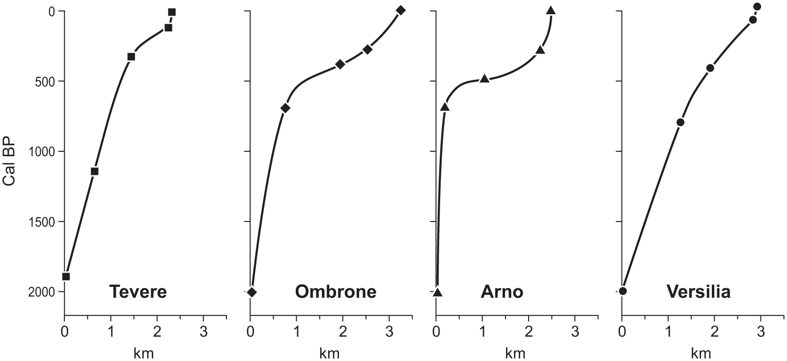
Phases of coastal advance on Apuo-Versilian plain (NW Italy) (after Bini et al., 2013).
Lake records
Although Lake Ledro (southern-central Italian pre-Alps at 650 m) is located to the northeast of our Italian study region, it provides us with a well-dated sedimentary sequence that has been the object of detailed sedimentological analyses. While there were relatively ephemeral phases of erosion between 8000 and ~4200 BP, the period between 4200 and ~3000 BP was a period of complex climatic oscillations that saw a significant increase in erosion (Magny et al., 2009; Simonneau et al., 2013). Undoubtedly, this was a consequence of the combined effects of climatic variations, but also the exposure of more extensive areas of soil after forest clearance by people. After this period, there is evidence for flooding centred on 1900 BP; then, there was an increase in flooding and erosion during the later medieval period and the Little Ice Age (Joannin et al., 2014; Magny et al., 2009b).
Alluvial
Based on 44 dates from alluvial zones in the Sabine mountains, evidence from central western Italy reveals the onset of a sedimentation phase at ~5500 BP. After 4200 BP, erosion increased, with one phase starting at ~4000 BP and a more significant period of erosion centred on ~3000 BP (Figure 7). Up until 2300 BP, these signals mainly come from the central parts of the river catchments. From the beginning of the Roman Period, sediment from the headwaters of the Turano basin was deposited in the Ricetto and Fosso Pechiera and the Ovito catchments. After this, there are a series of peaks in sedimentation (at 1750 BP, 1300 BP, 1000 BP and 700 BP) (Borrelli et al., 2014; De Vincenzo et al., 2013). The period around 1100 BP, saw the highest levels of sedimentation, probably enhanced due to the extended exposure of land surfaces (Mensing et al., 2015). Within this study area, the palynological work at Lago Lungo (Monti Reatini), provides a useful assessment of human engagement with this landscape from the Archaic Period (2700 BP) to the modern era (Figure 7b). Evidence for pasture and some impact on the forest is seen during the Imperial Period. This evidence for relatively limited Roman impact at this inland basin fits with the story of significant geographical variation in the levels of anthropogenic impact on Roman landscapes across the Mediterranean. The late Roman Period saw the increased impact on the forest and evidence for intensive human activity. The Medieval to late Medieval periods (~1100–600 BP) constitute a phase of significant human impact on the landscape, with the Little Ice Age seeing the recovery of forest (and reduced sedimentation) (Mensing et al., 2015).
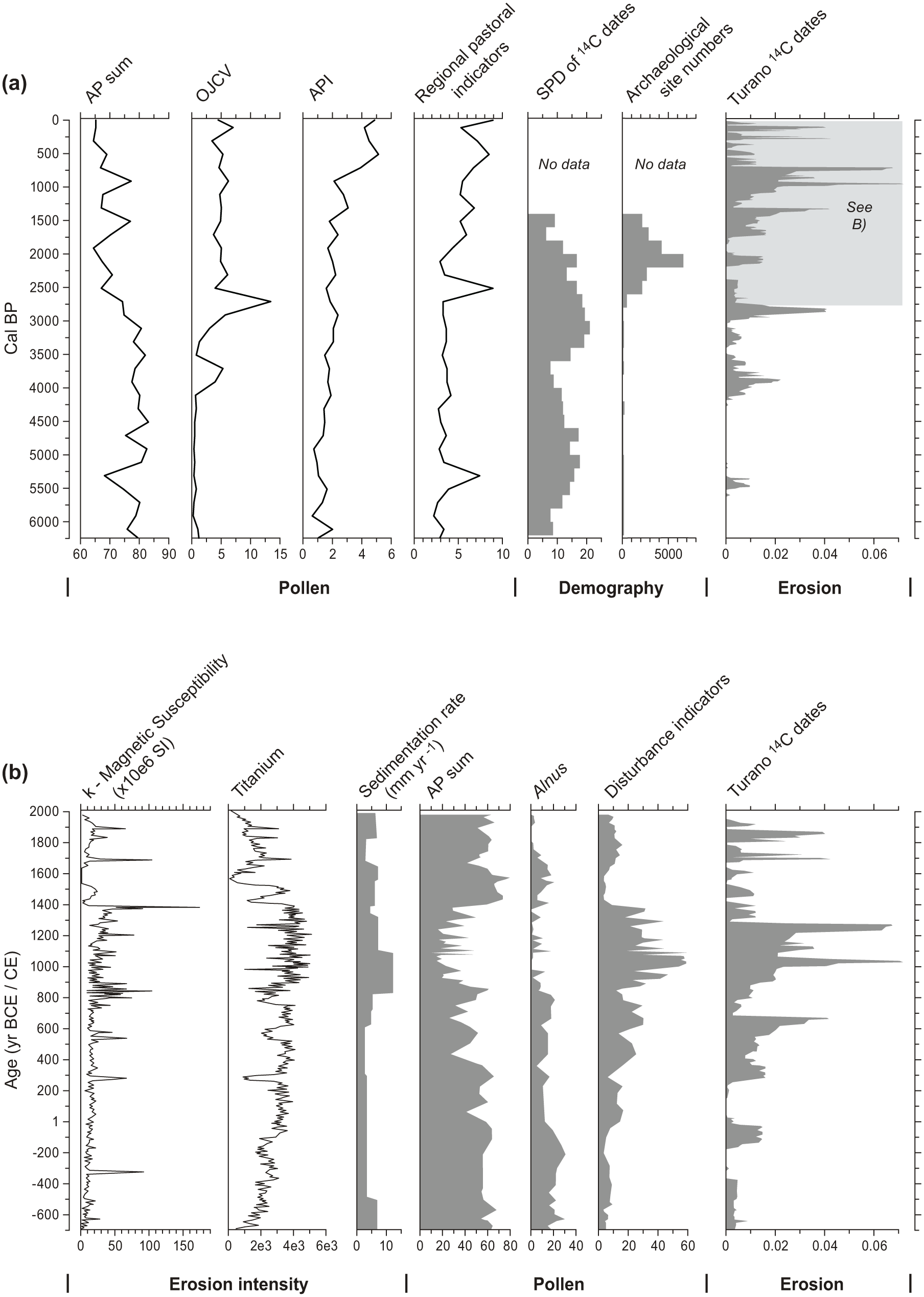
Italy (western central zone) (a) pollen indicator groups, archaeological site indices (SPDs and raw site counts) and erosion – flood events from Turano area (Borrelli et al., 2014; De Vincenzo et al., 2013; Stoddart et al., 2019). (b) Magnetic susceptibility and titanium signals with high peaks indicative of increased erosion, and sedimentation rate and rate and palynology and sedimentary data from Lago Lungo (Mensing et al., 2015) and Turano radiocarbon date density.
Palaeomagnetic and OSL dating of sediments from three adjacent catchments of a similar size, geology and relief; the Fiora, Marta and Treia (Brown and Ellis, 1996), is of particular interest as we can assume that these catchments experienced similar climatic conditions during the Holocene. The alluvial sequences of all three valleys show increased deposition at the beginning and end of the Roman Period (2400–1600 BP), which also coincides with both raised lake levels in Lake Bolsena and increased population growth in S Etruria (Brown and Ellis, 1996; Potter, 1979). Then, there is clear evidence for erosion and extensive alluviation again during the medieval-Renaissance period (900–300 BP) (Op cit.). Both phases broadly coincide with the record of wetter episodes within the predominantly dry late-Holocene record for central Italy as recorded both by the Tiber and Po flood records and by high levels of Lake Bolsena (Dragoni 1998).
In the Central Apennines (60 km northeast of Rome), the analysis of sediments from cores demonstrates significant phases of flooding between 2200 and 1500 BP with the Fosso delle Rosce’s alluvial plain extending upstream at ~1400 BP (Borrelli et al., 2013). The Roman phase of extensive flooding in the Central Apennines has also been identified by Giraudi (2005) and on the Tiber delta (Salomon et al., 2014). The main period of noteworthy flooding was from the 2nd century BC through to the 2nd century AD, this was followed by another phase from the 5th to 9th centuries AD (Op cit.). Also, we should note that Roman historical records reveal high flood-frequencies during the late Republican/early Imperial periods (Aldrete, 2007), which may well have been a consequence of significant forest clearance in some areas (Borrelli et al., 2013).
The most recent peak of flooding, 550–350 BP, coincides with rapid growth in the population of renaissance Rome and corresponds to both the Little Ice Age and increased agricultural pressure on its hinterland in order to feed Rome. This trend continued into the Little Ice Age. The sedimentary record reflects the flood and lake records, with the evidence suggesting a primary role for climate change, probably via a solar mechanism. The records also show that the sedimentary response was enhanced in the catchment closer to Rome (e.g. in the Marta and Treia catchments).
Colluvial – Geoarchaeological/geomorphological sections
There are relatively few studies of colluvial processes in this study area. We know that erosion from the Alban Hills dated to late Bronze Age to Iron Age resulted in deposition across the Pontine Marshes; probably the consequence of increased agriculture in the hills. To some extent, this colluviation allowed Imperial Rome to extend agricultural activity across the marshes, but this attempt at wetland management appears to have had limited success (Attema, 2017; Attema and de Haas, 2005; Sevink et al., 2013; Walsh et al., 2014). Slope erosion and enhanced geomorphological instability in the Italian Alps and the Apennines, are associated with the acceleration of landslide phenomena (Cremaschi and Nicosia, 2012) during the phase of climate variations between ~4000 BP and 2000 BP, coupled with a significant shift in land management and soil use.
Short resumé of demographic trends
The demographic indices for this study area suggest an increase in population (especially in the raw count statistic) during the late Neolithic and Chalcolithic (centred on 5000 BP). This is followed by a reduction in all demographic indices and then a mid–late Bronze Age increase across all values (from ~3500 BP onwards). Population increase is also apparent during the early Iron Age (3000–2700 BP). The late Republican/early Imperial Roman period (2100–1900 BP) is unsurprisingly a time of significant human activity, specifically seen in the archaeological site numbers statistic (Palmisano et al., 2017).
France
Coast
In the Camargue area, progradation took place during the late Neolithic and into the Copper and Bronze Ages (4500–3000 BP). However, the fastest rates of coastal advance occurred during the Roman Period (Arnaud-Fassetta and Suc, 2015). On specific archaeological sites, such as the Greek/Roman site of La Capelière, we see evidence for Iron Age to Roman flooding events, which resulted in the temporary abandonment of this part of the Camargue (Arnaud-Fassetta and Landuré, 2003). A broadly similar sedimentary history characterizes the coast further to the east around Fréjus where the deltaic zone of the river Argens expanded rapidly during the 1st century BC and prograded by about 1 m/yr up until the second century AD (Devillers et al., 2007). A similar pattern is observed around Marseille, where there is evidence for Bronze Age sedimentation. However, here it is with the advent of Greek, then Roman activity, that significant sedimentation occurred (Morhange et al., 1999).
Alluvial
A detailed high-resolution geochemical study of northern pre-Alpine Lake Bourget, based on measurements of terrigenous input, reveals four principal phases of erosion caused by climate changes and exacerbated by human activity: 4400, 2700, 2200 BP and at the end of the Wet Medieval Period around 1000 BP (3 centuries before the LIA climatic degradation) (Arnaud et al., 2012). In the southwestern Alps, detrital fluxes in lakes record the same trend with a general step around 4000/3500 BP when anthropogenic pollen increases (Brisset et al., 2017). For the central part of our Southern French region of study, we have chosen the most recent and most comprehensive dataset available. The cumulative probability distribution function (CPDF) for the Mid-Rhone Valley is founded upon a 25-year-long study of palaeosols and sediments. The erosion/aggradation curve in Figure 8 is based on 234 radiocarbon and chronocultural dates covering 13 millennia. This provides us with an exceptional example that can be contrasted with high-quality archaeological settlement/demographic data (for a detailed explanation of the methodology and statistical analyses, see Berger et al., 2016).
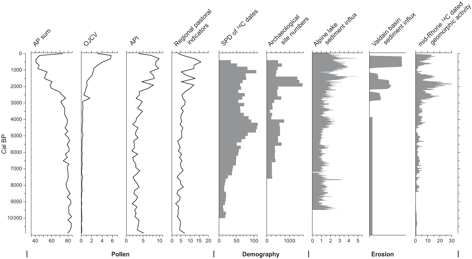
South of France, including mid-Rhone Valley pollen indicator groups, demographic indices (raw counts of sites, SPD of 14C dates; Berger et al., 2019). Flooding/erosion dynamics based on 234 14C dates from the Rhone Valley (Berger, 2015).
Most of the 14C dates come from the alluvial sequences of the lower valley of the Drôme River, Valdaine and Tricastin areas. The construction of the CPDF chronology is founded on the approach of extensive comparisons of sediments from fluvial systems, alluvial plains up to mountain slopes. It incorporates (1) signatures for the rapid filling of riverbeds, palaeomeanders, aggradation of levées to distal floodplains (referred to below as ‘hydrosedimentary’ activity) and (2) periods of sandy-gravel progradation associated with high-energy tractive currents that were the product of increased connectivity between the slopes and upper basins (Figure 8). This second category is described as “coarse sedimentation.” There are phases where we see the overlap of the erosional activity curves and pedogenesis. In most cases, these reflect cumulative dates with wide standard deviations (thus the overlap). However, some cases probably reveal the complexity and variation of spatially heterogeneous processes (including variations in human impact) across a set of complex topographic contexts.
During the early Neolithic, there was an initial phase of hydrosedimentary and coarse-sedimentary erosion centred on ~7200 BP; this segued into a phase of pedogenesis. The period between 6900 and 5600 BP saw some hydrosedimentary activity and particularly marked pedogenesis/stability, which peaked at ~5.5 BP. The late Neolithic/Copper Age (centred on 5200 BP) included phases of enhanced hydrosedimentary activity, leading into a period from ~4900 BP characterized by relatively low levels of erosion and pedogenesis/stability, especially from 4500 to 4300 BP. This phase transitioned to another complicated period (4200–3600 BP) comprising both hydrosedimentary and coarse erosion. Hill-slope erosion was relatively common from the Bronze Age to the start of the Iron Age (4000–2700 BP) (Notebaert et al., 2014). The early Bronze Age period witnessed the development of extended and intensified agricultural practices. Between 3500 and 2900 BP, there were two phases of hydrosedimentary activity with some coarse sedimentation, this phase also comprises evidence for pedogenesis, especially between 3000 and 2700 BP. This late Bronze Age to early Iron Age phase was immediately followed by one of the two most significant periods of hydrosedimentary and coarse sedimentation, lasting until ~2400 BP. This early to middle Iron Age period, with the development of a highly structured economic landscape, coincided with a wetter, cooler climatic period (Göschenen I glacial advance) and high lake levels in central Europe (Holzhauser et al., 2005). Less significant erosion and pedogenesis succeeded this period. The end of the Gaulish and the high Roman Empire (2100–1500 BP) coincided with the second significant phase of hydrosedimentary and coarse-sedimentary erosion (Notebaert and Berger, 2014). This period corresponds to the Roman Climatic Optimum. The erosion dated to the Little Ice Age and Medieval to modern periods appears less significant than that recorded for the preceding periods, but this difference is mainly due to the lack of datable material in the coarse gravel formations of the rhodanian braided-style rivers. Comparison of the sediment budget with data for settlement indicates the influence of settlement density and associated land use on soil erosion and sediment deposition.
Colluvial – Geoarchaeological/Geomorphological sections
Well-dated colluvial sequences are relatively rare, except in the Mid-Rhone valley. One synthesis of geoarchaeological research from across Provence, based on units dated via 14C or associations with archaeological material, clearly indicates phases of erosion dated to the late Neolithic/early Bronze Age (4000 BP), then the early Iron Age and the late Roman to early Medieval Period (Provansal, 1995). A sediment budget study on slope colluvial storage was undertaken across the Valdain Basin (Notebaert et al., 2013; Notebaert and Berger, 2014). Here, slope erosion decreased during the Bronze Age before an increase at the Bronze–Iron Age transition, which lasted until the Roman Period.
Corsica
On Corsica, geoarchaeological investigations in specific coastal zones reveal significant phases of alluviation broadly dated to the late Neolithic to Chalcolithic times (centred around the 5500–5200 BP RCC event as suggested by Mayewski et al. (2004)) and the Bronze Age (centred around the 4200 and 3200 BP RCC events). Evidence from the Tavignano River reveals deltaic plain development dated to the late Neolithic-early Chalcolithic (Ghilardi et al., 2017; Guttmann et al., 2013). On the Taravo River (SW Corsica), we see a significant phase of alluvial aggradation from the Middle Bronze Age (ca. 3200 cal. BP) with the Canniccia pond completely in-filled during the late Bronze Age (3200-2800 cal. BP) (Ghilardi et al., 2017). Here, sedimentological and magnetic parameters reveal a significant phase of alluviation (~3 m in three centuries) during the late Bronze Age, which was a period of intense cultural re-organization in the valleys of the island (Bagolini, 1996; Cesari and Peche-Quilichini, 2015). Research on the Sagone River (W Corsica) indicates that significant deltaic progradation occurred at the end of the late Bronze Age; a period with relatively low levels of human activity (Ghilardi et al., 2017).
Short resumé of demographic trends (southern French study area)
From 7500 BP, there is an increase in all demographic indices. These then fluctuate, followed by a definite increase and then plateau across all demographic measures from the late Neolithic through to the early Bronze Age (5600–4100 BP). The early Bronze Age (~4200 BP) is one of the most interesting; we see an increase in demographic signals leading into this period. The demographic indices suggest lower populations for the middle Bronze Age through to the start of the Iron Age. The Imperial Period comprises evidence for increased population levels.
Spain
Coast
In the Valencia area, sedimentation from the Turia River has resulted in coastal progradation, high magnitude flooding events between ~2800 and 2300 BP resulted in significant sand deposition, which was followed by levée formation from 2200 to ~1500 BP. The next significant processes comprised high magnitude flooding dated to ~900 BP (Carmona and Ruiz, 2011).
Alluvial
Thorndycraft and Benito’s synthesis of fluvial records from Spain (with most examples located in the eastern regions of the country) revealed clusters of alluvial/fluvial sedimentation events dated to 9630–8785, 7980–6860, 5800–4800, 3880–3085, 2895–1820, and 1300–0 BP. Since these are predominantly slackwater deposits, they reflect climate rather than land use effects. Of direct interest, is the phase between 3880 and 3085 BP that comprises two peaks of slack water flood deposits and alluvial overbank facies. There then followed a period from 2895 to 1820 BP with the highest pre/protohistoric peaks for slackwater deposits in conjunction with alluvial channel (gravel) facies (Thorndycraft and Benito, 2006). Wolf et al.’s work in the Jarama river also revealed phases of erosion (Central Spain), most of which broadly correspond with those identified by Thorndycraft and Benito’s, that is, periods of sedimentation between 8000 and 7000 BP, 5000 and 3100 BP, 2200 and 1800 BP, then at around 1000 BP and finally, at 400 BP (Wolf et al., 2015). The Guadalete River (southern Spain) records phases of almost synchronous aggradation at the Holocene scale around 8000-7000, 6600-5500, 4500-3800, 2300-1900, 1000-800 and 400 BP (Faust and Wolf, 2017) (see Figure 9).
North-eastern and south-eastern Spanish study zones pollen indicators, grey – demography for south-eastern area (Fyfe et al., 2019). Cumulative probability density plots (CPD) of radiocarbon dates from floods and extreme fluvial event units of the Iberian Peninsula (Benito et al., 2015; Thorndycraft and Benito, 2006; Wolf et al., 2015).
Work on the Lorca alluvial fan (southeast Spain), produced little evidence for sedimentary activity during the Neolithic, and stability and pedogenesis seemingly characterize the late Chalcolithic/start of the Bronze Age (soil horizons dated to 4400–4200 cal. BP). This is followed by a period of alluvial sedimentation during the later Bronze Age. Alluvial sedimentation is also dated to the late Iron Age. In summary, the data analysed indicate that sedimentation over the ancient fan-surface was negligible during the Neolithic and Chalcolithic (before 4500 BP) (Silva et al., 2008). In southeast Spain, it seems likely that enhanced sedimentation was caused by increased aridity during the late Holocene (reduced vegetation cover exposing soils and sediments), the principal phase dated to ~ 1300/1200 cal. BP (Bellin et al., 2013). In the Librilla ‘Rambla’ (Murcia), there is evidence for higher sedimentation–erosion rates during the Copper, Bronze and Earlier Iron Age (Calmel-Avila, 2002). A slightly different sequence of processes has been identified in the lower part of Guadalentín; here the important sedimentation phases are dated to 7500–5000 BP, 3400–1600 BP, 700 and the 400 BP (Baartman et al., 2011). Schulte’s (2003) work on historic period flooding reveals enhanced fluvial dynamics during the period 500–100 BP, while the assessment of late Holocene flood frequency and magnitude in this area by Benito et al. (2010) reveals a significant increase in high-magnitude floods during the 19th century.
Colluvial – Geoarchaeological/geomorphological sections
One study from the Lower Huerva Valley, Ebro Basin, NE Spain, identified slope deposits, where the lower unit is dated to 4346–4134 BP (late Chalcolithic) (Pérez-Lambán et al., 2014), while work in Central Spain (with OSL dates) reveals early to high Medieval Central Spain erosion (Ortega et al., 2017).
Short resumé of demographic trends
The demographic indices for the south-east ern Spanish study zone suggest an early Neolithic increase in human activity, but this is less apparent than in the north-east Iberian region. From the late Neolithic, through the Chalcolithic and into the early Bronze Age there was a steady increase in population. This trend came to a relatively dramatic end from 3600 BP onwards. There was a renewed increase during the Iron Age from ~ 2600 BP. Although we do not have SPD data for the Roman Period, we know that activity across the Spanish study area increased significantly during this phase, and this is reflected in the anthropogenic pollen signal.
As part of an OSL SPD analysis a database of 137 OSL dates was assembled from published and unpublished sources in Spain, Italy, Hungary, Turkey, Greece and the islands of Corsica, Malta and Crete. Here, we focus on those regions that produced more than 30 dates (Table 2). While this is lower than is ideal (which is over 250 dates), the pattern is far from uniform over time. As Figure 10 shows, the full dataset has distinctive peaks at 7800, 2400 and 780 BP. In the current dataset, the dates from Spain are the youngest with the youngest peak from the entire dataset at 520 BP. These data can only at this stage be regarded as preliminary due to the small dataset and therefore strong biases from the effects of individual studies. For example, the Spanish data are dominated (18 of 34) by the studies of slackwater sediments (Machado et al., 2017; Medialdea et al., 2014). These studies had different aims and therefore, different dating strategies. However, as more studies using OSL are undertaken, we will be able to judge if this east-west trend is a real artefact of site selection and apply more stringent quality control to the dataset.
SPD peak dates in yr BP from alluvial OSL dates in the Mediterranean (initial dataset). The ‘All’ dates row refers to the accumulated values from Spain, Italy, Hungary, Turkey, Greece and the islands of Corsica, Malta and Crete. Spain and Greece are detailed as the two zones with more than 30 dates each. Dates in bold are the highest SPD peaks in the set.

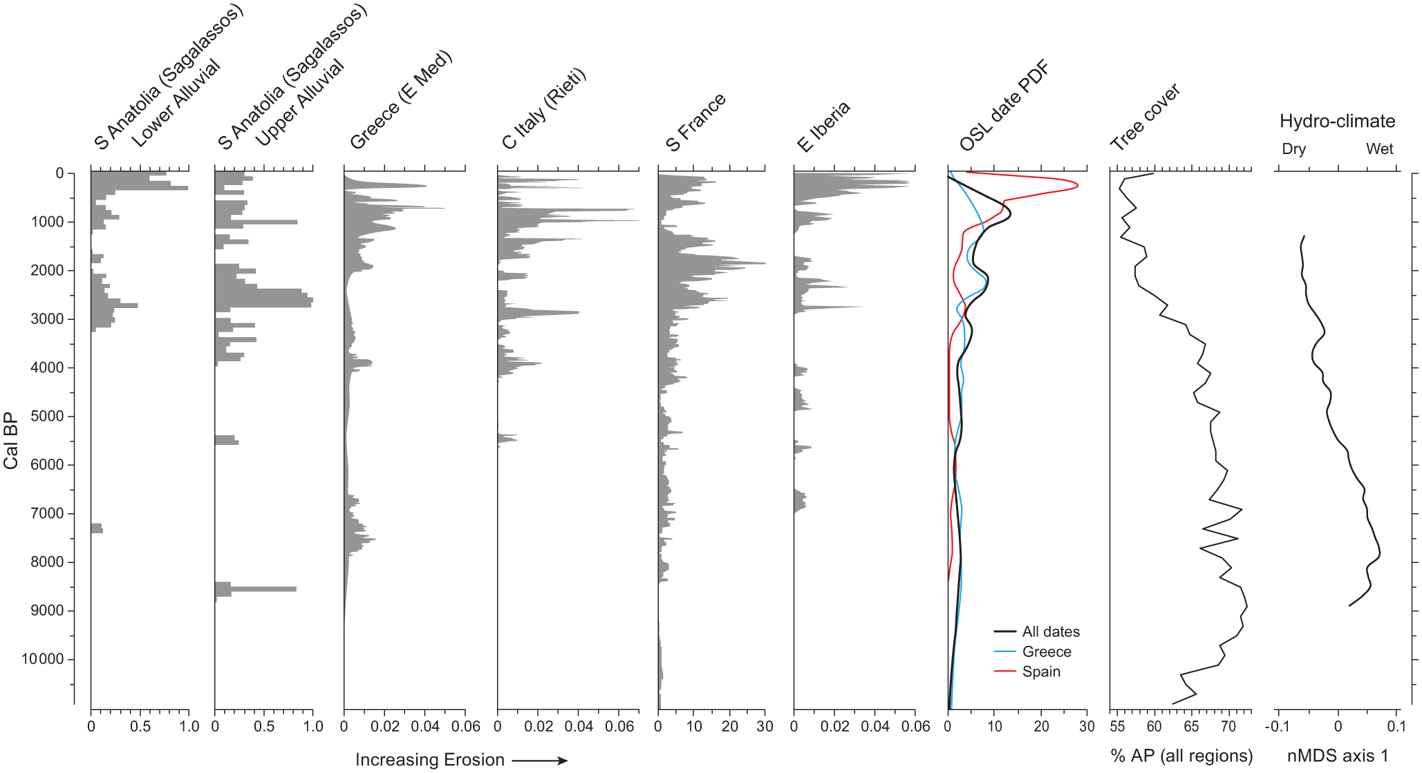
The principal erosion/flood records referred to in this paper involving radiometric date Probability Density Functions. From east to west (left to right): Sagalassos (Turkey), synthesis of Eastern Mediterranean floods and fluvial activity (mainly from Greece), flood events Turano area (Italy) flooding/erosion dynamics Rhone Valley (France), floods and extreme fluvial event units of the Iberian Peninsula, SPD of OSL dates from across the Mediterranean (all dates – thick black line, Greece – blue, Spain – red). % Arboreal Pollen for the Mediterranean (after Woodbridge et al., 2018). Final curve is the nMDS curve for hydro-climate data (Finné et al., 2019). Note the general trend from wetter conditions in the earlier Holocene towards drier conditions. This pattern is positive for all regions apart from northern Iberia; it is especially clearly marked in the Levant, Anatolia, the Balkans and S Iberia/Maghreb. nMDS allows the (shared) scaling of the data (e.g. δ18O, δ13C, δD) on a plot that collapses, or reduces the complex variability in these data that have been derived from 18 different sites.
Discussion
Here, we consider the pan-Mediterranean chronological trends via reference to the SPDs of 14C and OSL dates for erosion/sedimentation, the demographic and palynological evidence along with current assessments of climate changes during the Holocene.
Overall, geomorphological and geoarchaeological data indicate a marked increase in Mediterranean sediment dynamics during the last four millennia. However, there were substantial regional variations in timing, and significant oscillations in sediment fluxes were superimposed on the long-term upwards trend in sediment flux (Figure 10). The late Holocene acceleration in the rate of soil loss in the Mediterranean has parallels in other regions such as northwest Europe, where it has been linked primarily to human-induced forest clearance for agriculture on loess substrate (Dearing and Jones, 2003; Dotterweich, 2008; Hoffmann et al., 2010). In addition to land cover change, the increase in Mediterranean erosion has also been linked to Holocene aridification of the climate. More specifically, between 8500 and 6500 BP, southern and eastern regions were overall wetter than today, and then became progressively drier, with maximum aridity typically around 3000 BP (summarized as nMDS axis 1 in Figure 10). In northern and western Mediterranean regions, such as parts of Italy and Northern Iberia, a different and less coherent pattern of Holocene climatic change is registered (see Finné et al., 2019).
Human-landscape dynamics from the Neolithic onwards
In the eastern Mediterranean, the period between 7000 and 6000 BP saw initial aridification, followed by fluctuations between arid and humid phases. From 8000 to 7000 BP, the summary curve of isotope (e.g. δ18O, δ13C, δD) data from across the Mediterranean, represented as a number of sub-regional z-score means seems to show wetter conditions in all regions except for Northern Iberia. Here, conditions were dry from 8000 to 7400 BP followed by wetter conditions (see Finné et al., 2019).
The Eastern Mediterranean regional sedimentary signal suggests erosion during the 7th millennium BP. However, more localized studies yield little evidence for significant erosion during the early Neolithic, one exception being southern Greece, where the palynological evidence, the demographic and specific erosion indices intersect and suggest the emergence of an agricultural landscape, including pastoral activity, which resulted in some erosion (Figure 4). This period, during the 9th and 8th millenniium BP is also registered in Anatolia (Figure 3), and overlaps with the 8.2 ka event. In some areas, it is possible that even with relatively low population levels, the initial exposure of soil after deforestation was a moment when the geosystem was at its most vulnerable, especially in hilly/mountainous zones such as those in the Peloponnese.
The evidence from the South of France also allows us to suggest a change in the dynamics of the geomorphic system during the early Neolithic (Cardial) (centred on ~ 7300 BP) after an extended period of pedogenesis under moister conditions (Berger et al., 2016). The Anthropogenic Pollen Index (API) for the South of France fluctuates from ~7400 BP; increasing significantly then falling off to a low point at ~6200 BP. This combined evidence for human activity intersects with coarse-grained sedimentary erosion at ~7200 BP, during the initial intensification of Neolithic activity (late Cardial) (Berger et al., 2016) (Figure 8). A similar scenario is also possible for Spain, during the phase of Cardial neolithization. From about 7500 BP we see the start of human impact on forest/woodland, with regional pastoral indicator species increasing from ~6500 BP. There is some evidence for erosion at a regional scale where we have the intersection of an increase in population and some, albeit limited, erosion (Figure 9).
Late Neolithic to Bronze age – ‘Secondary products revolution’
After the 6th millennium BP, agricultural activity extended into the mountainous areas, limestone hinterlands and plateaux across much of the Mediterranean (Walsh, 2013, chapter 5). In many areas, this economic configuration comprised the ‘Secondary Products Revolution’; the intensified exploitation of milk, wool and animal traction for the ploughing of hitherto unexploited parts of the landscape (Evershed et al., 2008; Greenfield, 2010; Sherratt, 1981). There is relatively little evidence for significant erosion in the southwest Turkey case study area despite the significant rise in the Anthropogenic Pollen Index centred on 5500 BP, along with an increase in population centred on ~5000 BP (Figure 3).
Delta development across parts of Greece, Italy and Southern France during the late Neolithic may represent sedimentation initiated by human activity in the hinterlands, although the demographic and palynological data do not imply significant levels of human activity, but delta development is also strongly related to the mid-Holocene slowdown in relative sea level rise (Stanley and Warne, 1997). Here, we should also remember that erosion, as the removal and redeposition of sediment, can contribute to the creation of valuable land, and any assumption that erosion is by default a ‘problem’ should be questioned (Bintliff, 2002). Whatever the balance of causes, which must have varied geographically, the result was of human significance in producing an increase in useable, and later reclaimable, land largely due to the change in channel systems from braided to anatomising and straight patterns with levees; in the case of the Nile this had a dramatic effect on the potential productivity of the lower Nile valley (Penington et al., 2017).
For Southern Greece, the palynological data reveal an increase in agricultural/pastoral activity during the Chalcolithic and early Bronze Age, but this did not engender significant erosion. However, after ~4000 BP, the pollen and demographic indicators all record an increase in settlement activity and we do see a phase of erosion (Figure 5). This signal is also reflected at a regional level and is clearly represented in a peak in the summed probability analysis of OSL dates (Figure 10). There is a possibility that the extension and intensification of arable/pastoral activities into hitherto unexploited zones coincided with a period of climate change; a combination that resulted in significant erosion in some areas. In parts of the western Mediterranean, a humid phase started at ~5200 followed by aridification from ~4300 BP until ~3000 BP. An arid phase is also apparent in the east, centred on 4200 BP but was soon succeeded by relative humidity and then a new phase of aridity centred on ~3000 BP (Brayshaw et al., 2011; Roberts et al., 2011). The nMDS curves indeed suggest an increasing trend towards aridity from this point (Figure 10) as underlined by Magny et al. (2009); a product of orbital forcing. We should consider a scenario where pasture and ploughing (the introduction of new technologies, e.g. metal ploughs) moved into vulnerable landscapes. This is, in all likelihood, the period when significant agricultural terracing emerged to facilitate hill-slope agriculture within vulnerable, topographically complex, landscapes (Krahtopoulou and Frederick, 2008). In Greece and Crete, we see some evidence for erosion at around 4300–4200 BP (peak 2 on the OSL curve for Greece). A ‘Minoan Little Ice Age’ (ca. 5000–3000 BP) has been suggested by Moody (2000), a period when most of the investigated Cretan river valleys record several flood events, with Minoan pottery embedded within the coarse alluvial deposits. There is no doubt that across much of the Mediterranean, this period saw the complex combination of climatic variation, or unpredictability, coincide with the emergence of complex socio-economic systems. It is possible that some complex societies, with centralized ideological and socio-economic frameworks, stifled adaptiveness or resilience during periods of climatic stress. Therefore, it may not have been climate per se that caused erosion, but rather an intersection of complex socio-ecological processes (Weiberg and Finné, 2013).
In Italy, there is a short-lived spike in regional pastoral indicators during the late Neolithic. The next period of demographic increase corresponds to the late Neolithic and Chalcolithic (centred on 5000 BP). The period from ~3300 BP saw an increase in arboriculture (OJVC curve) and a relatively high demographic index (Figure 7). As with other regions, the phase of erosion seen here is in all likelihood the product of the combination of extended agriculture and a climatic context that exacerbated erosion, in particular, a dry-humid-dry oscillation centred on ~4000 BP (Finné et al., 2019; Magny et al., 2009; Zanchetta et al., 2016). In southern France, from the northern to the southern Alps, and in the Middle Rhone Valley, this story is repeated, with erosion centred on 4200 BP (Figures 8 and 10). In Italy and France, there is also a slight downturn in demographic indices. A similar scenario existed in Spain, although here, the phase of erosion and decline in population was between 5000 and 4500 BP (Chalcolithic); the period when complex fortified sites such as Los Millares developed.
Moving towards the end of the Bronze Age, in Greece, there is a relatively short-lived, albeit significant, peak in erosion during the late Bronze Age (~3200 BP, represented by peak 2 on the Greek curve for OSL SPD), a period with relatively high population levels and intensive agricultural activity. One of the most significant phases of hydrological activity occurred during the Minoan period (Ghilardi et al., 2018). In Italy, a phase of erosion just after 3000 BP precedes a peak in the SPD of 14C for demography. In France, while there is evidence for some late Bronze Age erosion, it remains moderate and the archaeodemographics and palynological indicators do suggest a significant change in land use intensity, a precursor to the significant phase of erosion at ~2800 BP that was amplified by a regional climatic degradation (Arnaud et al., 2012; Berger, 2015). In Spain, particularly in the south, there is a noticeable decline in activity that coincides with erosion and aridity, this evidence possibly reflecting the demise of the Argaric Culture (Castro et al., 1999, 2000; Gilman et al., 2015). From the demographic proxies, it seems that there was also a decrease in population after 3200 BP in some regions, such as Greece and Anatolia. In Italy, there is a downturn in demographic indicators (SPD of cal 14C dates) after 3000 BP (Figure 7). One well-known example, with collapse centred on 3200 BP, is the demise of the Terramare Culture (Bernabò Brea et al., 1997). However, this population decline is less apparent in France other than a small decline at around 3000–2900 BP towards the end of the Bronze Age (Berger et al., 2007).
Reduction of activity in some areas can be partly explained by complex systems theory (Cline, 2014). Climate change may well have been one of several problems that affected these societies, but the evidence for erosion, rather than being a simple consequence of climate change, might represent a form of maladaptation, which included the exploitation of hitherto underexploited landscape types; that is, complex, possibly rigid, socio-economic systems that failed to adapt to a range of problems, including networks of trade exchange focused on copper and bronze, new populations that undermined the palace economies of the eastern Mediterranean. These changes in the wider Mediterranean economic network had possible repercussions for other copper-producing areas, including the Alps (Carozza et al., 2015; Sherratt, 1998).
Iron age
There is evidence for significant erosion across much of the Mediterranean during the 3rd millennium BP (Figure 10). In Turkey and Greece, lake records and colluvial sedimentary sequences reflect this; the Turkish record is in some ways the most interesting as this moment constitutes the first major phase of erosion in the records considered here. In Anatolia, pollen evidence suggests human impact on the landscape during the late Bronze into the Iron Age. Comparison of geomorphological evidence from Nar Lake and Sagalassos with regional pollen and archaeo-demographic data (Figure 3) shows that erosion rates increased in these two areas after ~3000 BP, associated with the significant land cover change of the Beyşehir Occupation pollen phase, and the Hellenistic-Roman-early Byzantine (H-R-B) phase. Of particular significance was the pulse of colluvial inwash recorded in some basins within the region at ~2500 BP, that is, in the first centuries following major anthropogenic land cover change.
Interestingly, erosion appears to be less significant at the height of the Roman Period. Other studies, especially that of Casana, in the southernmost area of modern Turkey, reveal a similar pattern, albeit with a slightly later start date. Significant erosion and aggradation started after 1800 BP, suggesting that initial agricultural practices were sustainable and it was a phase of enhanced storminess that initiated severe erosion (Casana, 2008). In Greece, the OSL curve has a peak at 3000 BP, and evidence from alluvial records in northern Greece suggest significant erosion a few centuries later, during the Thracian Period. On Crete, the mid-3rd millennium BP sediments at Lake Kournas reveal the highest number of flood events for the entire Holocene. In Greece, the Archaic period, centred on 2600 BP, demographic indices are higher for the south than for the north. However, evidence in the north for ‘Thracian’ erosion is particularly evident. In Italy, population increase is also apparent during the early Iron Age (3000–2700 BP), which coincides with an increase in pastoral indicator species as well as an increase in erosion (Figure 4).
Significant erosion is also apparent in the south of France and Spain. As population levels and anthropogenic indicators of economic activity fluctuate across these regions, it is difficult to argue for a purely anthropogenic cause for this phase of erosion; it seems likely that climate change, shifting from arid to relatively humid in some areas, may well have driven much erosion. An important phase of flooding, which broadly corresponds with the Iberian Period (Benito et al., 2015; Jones et al., 2015; Thorndycraft and Benito, 2006), may well represent the combination of increased precipitation and human impact on and exposure of land surfaces in central and southern Spain. There is a peak in the SPD OSL curve and a peak in flooding (~2600 BP) (Figure 10). These trends also intersect with a transition from relatively arid to a humid climate in the south, this move to humidity taking place slightly later in the north (Finné et al., 2019). We should, however, consider the possibility of socio-economic instability, changing economic activities and practices, associated with the movement of Celtic peoples in parts of the region.
In France, the late Bronze Age to early Iron Age comprised two of the most significant periods of hydrosedimentary and coarse sedimentation at the Rhone basin scale and lasted until ~2600/2400 BP; the soil erosion rate significantly increased compared to previous periods (Berger, 2015; Notebaert and Berger, 2014). It resulted in a generalized metamorphosis of rivers towards braided forms across pre-Alpine basins. This process was very much a product of dense, coarse sedimentary loads that far exceeded the discharge capacity of rivers (Berger et al., 2008). This early-middle Iron Age period, with the development of a highly structured economic landscape, coincided with the Göschenen I glacial advance and the major lake transgressive period of Bourget (Magny et al., 2017). Finally, demographic growth occurred across our Iberian case study areas. In fact, the period centred on 2600 BP comprises an ephemeral peak on the anthropogenic palynological indicator species as well as pastoral species.
Roman republican and imperial period
The Roman Period presents us with some interesting variations across the wider Mediterranean region. First, the demographic evidence from Turkey suggests a peak of activity centred on ~1900 BP. Pastoral activity was relatively stable and remained so for much of the Roman Period, which also saw an increase in arboriculture (represented by increases in the OJCV curves (Figure 3)). Despite, this, the studies presented in this paper suggest relatively modest levels of erosion, although the regional summed probability analyses of floods and alluvial events for the Eastern Mediterranean show an increase in these events centred on 2000 BP (Benito et al., 2015). In southern Greece, Fuchs’ work reveals the most significant phase of erosion for the entire Holocene, while on Crete, the peak of flood events seen during the Classical Period waned by ~2000 BP. In the north (Macedonia, Thrace), there is some erosion, but again, this is less significant than that dated to the Thracian Iron Age. Unsurprisingly, this is a period of extensive and intensive economic activity, as revealed by the palynological and demographic data. However, moving into the Greco-Roman Period, there is evidence for a decline in population, or indeed, a reduction in site numbers in some areas, including the Peloponnese (Weiberg et al., 2016; Weiberg et al., 2019). In Italy, the late Republican/early Imperial Roman period (2100–1900 BP) is unsurprisingly a time of substantial human activity (Palmisano et al., 2017). The evidence for erosion in some areas is limited (e.g. The Rieti Basin (Mensing et al., 2015)), although significant floods and erosion are apparent in other records, and are certainly recorded in historical documents referring to the Tiber River (Aldrete, 2007). In the Rhone Valley-South of France area, there is a clear set of coinciding signals of population increase, intensification of all forms of agricultural practice, some of which were highly erodible vineyards, and erosion is seen across all parts of the landscape with a definite increase of hydrosedimentary connectivity across the Rhone catchments. Across the Iberian study areas, although there is evidence for erosion dated to the Roman period, this may not have been as significant as in other parts of the Mediterranean. Perhaps one of the most noteworthy elements in the Northern Iberian story is the evidence for an extremely wet climatic phase centred on the centuries either side of 2000 BP.
We must consider the possibility that much erosion during the Roman Period was caused by the intensification of economic activity, coupled with enhanced late-summer storms that resulted in some significant erosion events. The Roman Climatic Optimum/Roman humid Period (a relatively warm and humid period centred on 2200–1900 BP) is considered a relatively ‘moist’ period (Goudeau et al., 2015; McCormick et al., 2012; Reale and Dirmeyer, 2000), with higher temperatures and humidity (Chen et al., 2012). However, the increase in climatic moisture did not exist across all parts of the Mediterranean (Finné et al., this volume). It is also possible that late summer and autumn periods saw significant storm events that may well have exaggerated erosion signals in some areas, as observed in the French Alps (Giguet-Covex et al., 2012). A high flood frequency is recorded in the Languedocian rivers during the Gallo-Roman Period (Berger et al., 2003). In addition, there was rapid progradation of continental river deltas such as the Rhone as well the Argens, Aude, Tiber (Arnaud-Fassetta and Landuré, 2003). The causes of these changes were a combination of human forcing and regular rainfall, especially around 2000 BP (Berger and Bravard, 2012). We know that Roman writers/agronomists were aware of erosion (Columella et al., 1948; Dotterweich, 2013), or at least, variation in soil quality (e.g. Varro, see Loeb et al., 1934), but it is difficult to demonstrate the demise of agricultural production. Any shortfalls in agricultural yields could, of course, be mitigated by the extensive and comprehensive connected economic network which guaranteed the movement of surpluses around the empire (Horden and Purcell, 2000). Despite the evidence for Roman impact and management of the environment, claims for extreme, generalized, forest clearance and concomitant environmental degradation is misplaced (Harris, 2013; Hughes, 1994, 2005). Based on our assessment, it is difficult to assign 2000 BP as the inception of the Anthropocene (Certini and Scalenghe, 2011), but there is no doubt that some areas, including parts of Gallia Narbonensis, did witness significant anthropogenic erosion at this time.
Late Roman to medieval period and the Little Ice Age
In the Eastern Mediterranean, the late Roman to early Medieval Periods witnessed relatively high levels of erosion in line with Vita-Finzi’s (1969) “Younger Fill.”. The final and highest peak in the OSL curve for Greece falls at 1300 BP (Figure 10). Erosion in Turkey and Greece falls off after ~1300 BP but increases as we move into the Little Ice Age. The data from Italy reveal high levels of erosion at ~ 1400 BP, then again at ~1000 and 800 BP. Surprisingly, despite some Little Ice Age erosion; this does not appear as significant as some other areas in the Mediterranean. In the South of France, the late Roman to early Medieval periods also saw high levels of erosion at ~ 1400 BP, albeit, less significant than during the preceding centuries (but with regular high energy dynamics). The High Medieval Period (~1000–800 BP), comprising a phase of wetter climatic conditions in some eastern parts of the Mediterranean, but drier conditions in Iberia and parts of the Balkans, saw little erosion with concomitant pedogenesis/stability. Finally, the Little Ice Age is unsurprisingly characterized by a period of hydrosedimentary and erosion comprising coarse sediments, although, despite extensive and intensive agriculture, this erosion is less significant than in some previous phases. This is possibly due to the chronological and geographical interests of geomorphologists. In the south of France, combined climatic and anthropogenic forces led to erosion across entire catchments; from the mountains to the plains (Bravard, 2010; Notebaert and Berger, 2014). The evidence for southern Spain a phase of erosion centred on 1000 BP, then relative stability followed by significant erosion/floods during the late and post-medieval periods, reflected in the final and most prominent peak in the OSL curve centred on 520 BP. This, as elsewhere, is undoubtedly a response to intensive agricultural activity and unstable climate.
Conclusion
Our regional syntheses are innovative, but only a point for departure towards more focussed sub-regional and catchment-based integrated projects. Although there are some broadly contemporary phases of erosion across the Mediterranean, such as that centred on ~4000 BP, the current state of our data does not allow or support simple causalities, that is, the role of climate versus people. There is little doubt that this (~4000 BP) period can be characterized in some areas as a tipping point, or a significant moment for many landscape trajectories. In the case of the coastal zone, the natural slowdown in RSL rise combined with human-induced sedimentation had a significant effect in the creation of productive marsh and agricultural land, which in some cases may have had significant demographic consequences (Bruckner et al., 2006; Penington et al., 2017). Then, between 3000 and 2000 BP, the fluctuations in climate combined with economic intensification across complex societies did result in significant landscape changes and increased soil degradation, and some areas crossed an irreversible threshold. What is clear from Figure 10 is that the mid-Holocene aridification of the Mediterranean climate was not, on its own, enough, to increase erosion rates to the levels experienced in pre-modern times. It was only when there was a substantial and sustained increase in rural population and in woodland conversion to farmland and pasture, and the perturbation of soil structure via the extension in use of metal ploughs, that sediment flux rates increased to well above their long-term geological norm. This transition typically took place during the 3rd millennium BP. Thus, while climate change may have been a key pacemaker for erosion events and a necessary condition for increased erosion, it was not a sufficient condition in the absence of human impact. Although many local studies indeed suggest that sedimentation phases in the late Holocene are poorly correlated to climate signals, the role of climate cannot be neglected for several periods of increased geomorphic activity, especially when regional scales are considered (Bravard, 2010; Bellin et al., 2013; Faust et al., 2004). For arid to semi-arid regions like south-eastern Spain or Tunisia, geomorphic instability is often correlated to drier periods that further degrade the vegetation cover making the landscape more vulnerable to the increasing frequency of torrential rain events, and the intensification of regressive erosion due to lower aquifers that often accompany a dry period. Such landscapes are also less resilient to human pressure, and thus human activity may intensify the climatic effect. In other regions, the return to humid conditions triggers more intense erosion, which again may be amplified through human activity. As Bellin et al. (2013) suggested: ‘improved hydrological conditions are associated with both reduced geomorphic stability and accelerated geomorphic instability dependent on the human impact on the environment’ (p. 124).
Perhaps one of the most complex and interesting phases of human-environment interactions from our perspective is the Roman Period. Notwithstanding the evidence for Roman impact and management of the environment, the notion of forest clearance and concomitant environmental degradation is problematic in many areas, despite the claims of some writers (Harris, 2013; Hughes, 1994, 2005). There is even variation in the flooding and erosion levels associated with the Little Ice Age; one interesting signal is that derived from the analysis of OSL dates that reveals a significant peak in Spain. It is difficult to claim that soil loss or erosion was responsible for the decline or demise of any of the societies considered here, although there is little doubt that soil erosion did contribute to localized problems and even forced populations movement (for a useful discussion of general issues, see Dotterweich, 2013). The problem of causality is aggravated by the positive feedback loop between climate and erosion, in that increased rainfall in semi-arid climates can both increase agricultural productivity and thereby intensify and natural erosion rates, with the opposite being true for reductions in effective precipitation (Brown and Walsh, 2017). Moreover, the fact that some of the most significant erosion signals occur during periods when we know that societies remained resilient obliges us to consider more complex socio-environmental frameworks (Butzer and Endfield, 2012), where certain societies managed soil erosion due to adaptive forms of environmental knowledge while others were less successful.
Footnotes
Acknowledgements
Pollen data were extracted from the European Pollen Database (EPD; ![]() ), and the work of the data contributors and the EPD community is gratefully acknowledged. We should also like to thank the illustrators in the Geography Department at Plymouth, Southampton and Helen Goodchild at York. We would also like to thank the three anonymous reviewers for their comments, which allowed us to enhance this contribution.
), and the work of the data contributors and the EPD community is gratefully acknowledged. We should also like to thank the illustrators in the Geography Department at Plymouth, Southampton and Helen Goodchild at York. We would also like to thank the three anonymous reviewers for their comments, which allowed us to enhance this contribution.
Funding
The PALEOMEX-MISTRALS program of the CNRS partly supported the research of the French scientists, and Kevin Walsh wishes to acknowledge the support for a research fellowship at IMéRA, Aix-Marseille University, Marseille (Cofund EURIAS, Labex RFIEA and ANR-Investissements d’avenir).