
Abstract
We here preset a result of high-resolution pollen data of a lacustrine-peat sediment core from Yushenkule (YSKL) Peat, southern Altai Mountains, northwestern China. We aim to reconstruct the palaeovegetation and palaeoclimate variations in the southern Altai Mountains and further evaluate the role of autogenic process of the raised bog itself in driving the local vegetation dynamics. The pollen data of YSKL core-2 show two major vegetation stages in YSKL Peat area and the surrounding areas during the data-covering period. During the stage lasting from ~4870 to ~2550 cal. yr BP, regional vegetation was dominated by desert steppe and local vegetation in YSKL Peat was characterized by Artemisia-dominated mountain steppe. During the stage lasting from ~2550 to ~700 cal. yr BP, regional vegetation was characterized by Artemisia-dominated steppe and local vegetation in YSKL Peat was characterized by Cyperaceae-dominated wetland herbs. The Ar/Am (Artemisia/Amaranthaceae) ratio-indicated moisture increasing trend of southern Altai Mountains can attribute to the combined effects of decreased temperature and increased precipitation. The lithologic transition from lake to peat of YSKL core-2 can be explained by invoking the variations in the areal extent of ice covers in the Altai Mountains.
Introduction
Climatologically, the Altai Mountains range has been regarded as the divide between the East Asian monsoon-influenced eastern ACA (i.e. Arid Central Asia) and the westerlies-influenced western ACA (Blyakharchuk et al., 2007, 2008; Harrison et al., 1996; Rudaya et al., 2009). ACA refers to the vast arid area extending from the Caspian Sea in the west to the central Mongolian Plateau in the east (approximately 50–100°E). Biogeographically, the Altai Mountains range strides over both the Central Asian steppes in the south and the Siberian taiga forests in the north (Rudaya et al., 2012). The Altai Mountains range is therefore an ideal area for tracking the past vegetation dynamics and the associated climate changes (Blyakharchuk and Chernova, 2013; Blyakharchuk et al., 2014).
Long-term trends of the Holocene climate changes in the Altai Mountains and the surrounding areas have been reasonably depicted (e.g. Blyakharchuk et al., 2004, 2007, 2008; Grunert et al., 2000; Huang et al., 2018; Ran et al., 2015; Rudaya et al., 2009, 2012; Schlütz and Lehmkuhl, 2007; Sun et al., 2013; Unkelbach et al., 2017; Wang and Feng, 2013; Zhang and Feng, 2018). However, the vegetation dynamics in the higher elevation areas show differential sensitivity compared with the lower elevation areas in the Altai Mountains during the Holocene (Huang et al., 2018). By far, little attentions have been paid in examining the local-scale processes contributing to the variations of vegetation composition in the Altai Mountains and the surrounding areas, impeding our better understanding of the relationship between vegetation and climate changes.
Here, we report a relatively high-resolution pollen record covering the late Holocene (from ~4870 to ~700 cal. yr BP) obtained from YSKL Peat in the southern Altai Mountains (i.e. Chinese Altai) with a hope that our understanding of the late-Holocene vegetation and climate changes in the Altai Mountains and the surrounding areas can be elevated. In this paper, we attempt to achieve three objectives: (1) reconstruct vegetation dynamics around the YSKL Peat based on pollen assemblages, (2) regionally delineating the late-Holocene climate variations through temporal comparisons with other data, and (3) explain the controlling mechanism of vegetation and climate variations over the middle to late Holocene in the southern Altai Mountains.
Study area
YSKL Peat (approximately 46°45′–46°57′N and 90°46′–90°61′E; 2636 m a.s.l.), presently a subalpine peat bog, is situated at the southeastern slope of the southern Altai Mountains (i.e. Chinese Altai), northern Xinjiang of China (Figure 1a and b). The bog encompasses ~11.8 km2 in a U-shaped valley and was evolved from several separate alpine lakes (Figure 1c). The present-day YSKL Peat is actually the headwater of the Xiaoqinggeli River that injects into the Ulungur Lake in northern tip of the Junggar Basin in northern Xinjiang. According to field surveys, the modern water-table depth of YSKL Peat is less than 0.5 m and the peat is fed primarily by precipitation (Zhou, 1999) and secondarily by underground water (Shi, 2005).
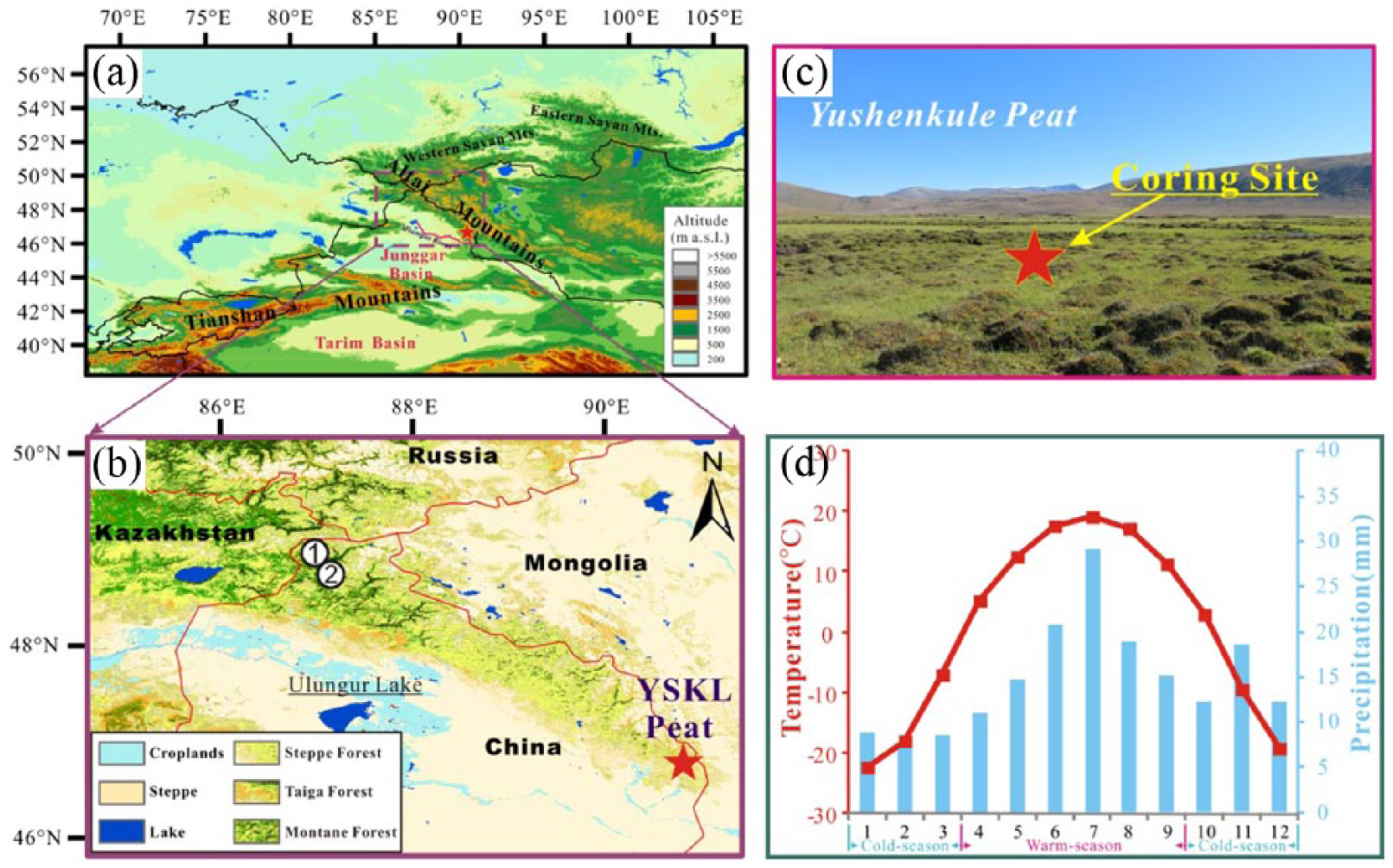
Physiographic settings of YSKL Peat. (a) Geomorphic and topographic backgrounds. (b) Biogeographic backgrounds of the Altai Mountains and surrounding areas. The cited sites of climate sequences (i.e. white filled circles) including 1, Narenxia Peat and 2, Kanas Lake. (c) Photo of YSKL Peat and the coring site (red pentagram). (d) Averages of monthly temperature and averages of monthly precipitation recorded at nearby Qinghe Meteorological Station (1957–2007).
The instrumental records (1957–2007) at nearby Qinghe Meteorological Station (1218 m a.s.l.), ~42 km from the YSKL Peat, recorded a mean annual precipitation (MAP) of 177.7 mm. The warm-season (April–September) precipitation accounts for 61% (109.4 mm) of MAP and the cold-season precipitation (October–March) for the remaining 39% (67.9 mm). The mean annual temperature (MAT) is −0.2°C and the coldest and warmest months of the year are January (Tc, −23.5°C) and July (Tw, 18.5°C), respectively (Figure 1d).
The climate in the Altai Mountains is dominated by westerly airflow throughout a year with the influence of the Siberian high-pressure system during winters (Aizen et al., 1995). Vegetation distribution of the Altai Mountains well reflects the N–S gradients of decreasing moisture and increasing temperature and also reflects the W–E gradients of decreasing moisture and increasing climatic continentality (Feng et al., 2017). Our study area, YSKL Peat (46°49′ N, 90°52′E), is bioclimatically situated in the northern temperate desert steppe zone. But, the high elevations of the Altai Mountains promote the development of vertical vegetation zones. As shown in Figure 2b, vegetations from the highest elevation (~3500 m a.s.l.), through the YSKL Peat (2636 m a.s.l.), to the Qinghe Meteorological Station (1218 m a.s.l.) exhibit evident vertical features. Generally, the alpine zone (between ~3500 and ~2000 m) includes alpine tundra vegetation (mainly including Saussurea involucrata, Callianthemum alatavicum, Valeriana fedtschenkoi, Geranium saxatile, Potentilla chinensis) between ~3500 and ~2700 m, alpine meadow (mainly including Carex atrofusca, Alchemilla sibirica, Poa angustifolia, Polygonum viviparum), and alpine steppe (mainly including Festuca kryloviana, Kobresia) between ~2700 and ~2200 m. Further down, needle-leaved forests (mainly Larix sibirica) occupy the shady slopes (i.e. north-facing and west-facing slopes) and broadleaf deciduous scrubs (mainly including Rosa sericea, Cotoneaster adpressus, Sabina pseudosabina) occupy the sunny slopes (south-facing and east-facing slopes) of the elevations between ~2200 and ~1500 m. The shady slopes of the elevation zone between ~2000 and ~1700 m are occupied by grass and forb meadow (mainly including Calamagrostis epigejos tall grass meadow, Carex spp., forb meadow). Arid steppe (mainly including Stipa capillata, Artemisia frigida, Ajania fastigiata, Aster) occupy the sunny slopes of the elevations between ~1500 and ~1000 m. The lowest portion (i.e. below ~1000 m a.s.l.) is covered with desert steppe (mainly including Stipa sareptana, Seriphidium borotalense, S. sublessingiana, S. transilense, Kochia prostrata) (Zhang, 2007). It should be particularly pointed out that the modern vegetation around the YSKL Peat (2636 m a.s.l.) is dominated by alpine meadow (Abdusalih et al., 2008).

(a) Vegetation around the Yushenkule (YSKL) Peat (Zhang, 2007). (b) Schematic diagram showing the vertical zones of vegetation distribution around Yushenkule (YSKL) Peat in the context of the southeastern Altai Mountains.
Materials and methods
Stratigraphy and chronology
A 180-cm lacustrine-peat core (46°49′N, 90°52′E, 2636 m a.s.l.), that is, YSKL core-2, was retrieved from YSKL Peat with a Holland-made peat corer in the summer of 2012. It should be particularly noted here that an 88-cm natural exposure sampled in 2012 was named as YSKL core and the carbon isotopic data were reported in Yang et al. (2019). The YSKL core-2 can be stratigraphically divided into three units (Figure 3). Unit 1 (180–80 cm) is a lacustrine deposit. Unit 2 (80–45 cm) is a transition layer from lacustrine deposition to peat accumulation. Unit 3 (45–16 cm) is a peat layer. It should be mentioned that samples of the topmost 16 cm were not successfully retrieved. Two peat plant samples and four lacustrine bulk samples were chosen for radiocarbon dating at the NSF-AMS Facility, University of Arizona (Table 1). The 14C ages were calibrated to calendar years before present (BP = AD1950) with the program CALIB 6.0 using INTCAL 09 (Reimer et al., 2009). Assuming that the age of surface layer is AD2012, an age–depth model was generated using a cubic spline interpolator with Bayesian statistical methods (Blaauw and Christen, 2011) based on the six 14C ages (Table 1), and the sediment core time-series data presented are based on the weighted mean ages modeled using Bacon software (Figure 3). The simulated chronological result shows that the age in the depth of 16 cm is ~700 cal. yr BP and the bottom age (i.e. at the depth of 180 cm) is extrapolated to be ~4870 cal. yr BP.
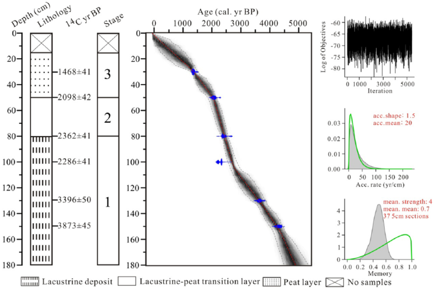
Stratigraphy and depth–age model of the Yushenkule core-2.
AMS 14C dating results of Yushenkule core-2 (AA: laboratory code of NSF-Arizona AMS 14C dating facilities).

Pollen analysis
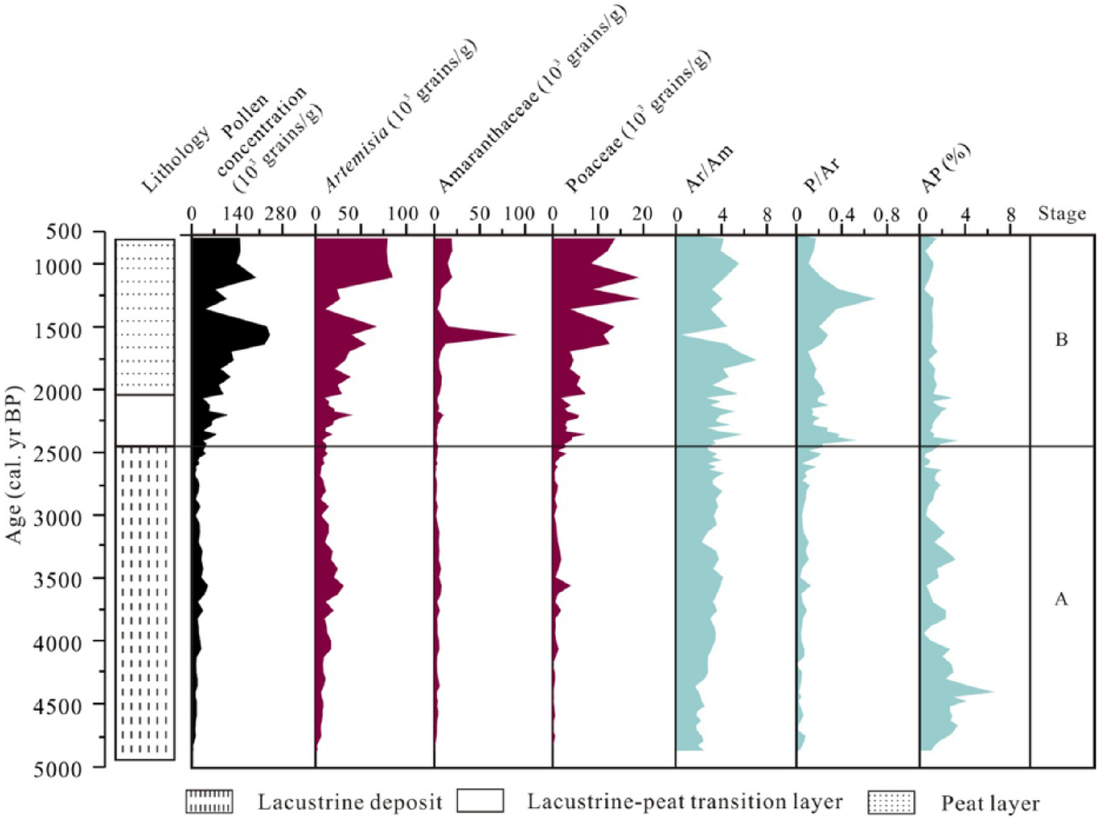
Sediment samples from YSKL core-2 were collected at 2-cm interval and a total of 90 samples were treated for pollen analysis. One Lycopodium spore tablet with a known number of Lycopodium spores (27,560 ± 250 grains) was added to each sample prior to processing for calculation of pollen concentration. The sediment samples were first treated with HCl (5–10%) and HF (36%) to remove carbonates and silicates and then sieved through a 10-μm mesh size to remove small clay particles, dehydrated with tertiary-butyl alcohol, and mounted in glycerin oil. The treated samples were mounted on slides and examined with a transmitted light microscope (Olympus BX 51) at 400×magnification. A minimum of 350 pollen grains (not including spores and aquatic pollen) were counted from each sample. Pollen types were identified with the pollen references (Moore et al., 1991; Wang et al., 1995). Pollen percentages were calculated based on the sum of all counted pollen grains and the pollen diagrams were plotted using Tilia and Graph software. The constrained incremental sum of squares (CONSIS) cluster analysis was used for dividing the pollen zones.
Results and interpretations
Using the CONISS, we palynologically divide the YSKL core-2 into two major zones based on the major pollen taxa (Figure 4): Pollen Zone A and Pollen Zone B. The Pollen Zone A (~4870 to ~2550 cal. yr BP) is readily distinguishable from the Pollen Zone B (~2550 to ~700 cal. yr BP) by three major features: (1) higher pollen percentages of Artemisia and Amaranthaceae, (2) lower pollen percentages of Cyperaceae and Poaceae, and (3) a lower total pollen concentration.

Pollen data of Yushenkule core-2 and CONISS-based divisions of pollen assemblages.
Pollen Zone A (180–90 cm; ~4870 to ~2550 cal. yr BP) is stratigraphically correspondent with the majority of the lacustrine deposit (180–80 cm). This zone is dominated by herbaceous components including Artemisia (42.8–72.0%), Amaranthaceae (11.8–33.3%), Cyperaceae (0.8–31.1%), and Poaceae (0–8.8%) with a sizable portion of tree components mainly including Betula (0–5.5%), Pinus (0–2.8%), and Picea (0–2.3%). This zone can be further divided into two sub-zones: A-1 and A-2. Sub-Zone A-1 (180–150 cm; ~4870 to ~4200 cal. yr BP) can be readily distinguished from Sub-Zone A-2 (150–90 cm; ~4200 to ~2550 cal. yr BP) by four features: (1) higher percentages of Pinus (average value: 0.4%) and Betula (average value: 2.2%) pollen, (2) a higher percentage of Amaranthaceae pollen (average value: 26.7%), and (3) lower percentages of Caryophyllaceae (average value: 0.3%) and Cyperaceae (average value: 3.9%) pollen.
Pollen Zone B (90–16 cm; ~2550 to ~700 cal. yr BP) includes the entire lacustrine-peat transition layer (90–45 cm) and the entire peat layer (45–16 cm). This zone is typified by a remarkable increase in Cyperaceae (12.1–64.8%, average value: 45.6%) and Poaceae (3.1–18.1%, average value: 7.1%) pollen percentage at the expenses of Artemisia (16.7–57.8%, average value: 32.3%) and Amaranthaceae (3.6–38.2%, average value: 9.3%) pollen percentages with an averagely high pollen concentration (23,493–24,0641 grains/g). This zone can be further divided into two sub-zones (i.e. B-1 and B-2).
Sub-Pollen Zone B-1 (90–24 cm; ~2550 to ~1100 cal. yr BP) is characterized by a drastic increase in Cyperaceae (average value: 48.0%) pollen percentage at the expenses of Artemisia (average value: 30.2%) and Amaranthaceae (average value: 9.0%) pollen percentages. Three more features are also notable: (1) it is the only pollen unit (or sub-zone) where Larix (mean value: 0.3%) pollen percentage reaches bioclimatically meaningful levels, (2) Poaceae (average value: 7.0%) pollen percentage reaches the maximum of the entire core, and (3) the pollen concentration (average value: 85,915 grains/g) reaches the maximum of the entire core.
Sub-Pollen Zone B-2 (24–16 cm; ~1100 to ~700 cal. yr BP) is typified by a drastic decrease in Cyperaceae (average value: 13.8%) pollen percentage and corresponding increases in Artemisia (average value: 54.7%), Amaranthaceae (average value: 12.2%), and Caryophyllaceae (averae value: 6.2%) pollen percentages. It should be reminded that samples of the topmost 16 cm overlying this sub-zone were not successfully retrieved and this sub-zone (i.e. B-2; 24–16 cm) is represented only by four samples.
Discussion
Vegetation and climate changes during the past ~5000 years
As shown in Figure 2b, YSKL Peat is located in the alpine meadow zone of the upper tree-ling with Larch forest, steppe, and desert steppe dominated the lower elevation area. The surface pollen data analysis from northern Xinjiang (including YSKL Peat) (Li et al., 2015, 2017; Luo et al., 2009, 2010; Yan and Xu, 1989) showed that there are different pollen assemblages in above vegetations. Specifically, subalpine meadow/steppe is characterized by the highest content of Cyperaceae (>20%) with sizable portions of Poaceae, Compositae, Rosaceae, Cruciferae, Thalictrum, Caryophyllaceae, and Polygonum; Larch forest is typified by highest content of Larix (>30%) with sizable portions of Betula and Poaceae; steppe is generally characterized by highest content of Artemisia (15–70%) with sizable portion of Amaranthaceae (<20%); desert steppe is always typified by the dominances of Artemisia and Amaranthaceae (together exceed 50%).
As shown in Figure 3, a dominant lithologic feature of YSKL Peat core-2 is that the deposition evaluated from lake to peat, indicating significant changes in pollen sources area. Previous studies based on lake surface sediments and wetland/swamp surface samples in the Xinjiang region show that the pollen assemblage of lake surface sediments is characterized by more exotic pollen from regional areas than wetland/swamp surface. The former, that is, pollen assemblage of lake sediments, reflects regional vegetation variations (Huang et al., 2004; Tao et al., 2013). The latter, that is, pollen assemblage of wetland/swamp, generally reflects local vegetation variations. The overwhelming pollen percentage of Cyperaceae produced from the development of peatland makes the pollen percentage assemblages (see Figure 3) misleading and further impedes our understanding of regional vegetation variations. To dependably understand the regional vegetation variations of YSKL Peat and surrounding areas, we add on the concentrations diagram of Artemisia, Amaranthaceae, and Poaceae for discussion (Figure 4).
Modern pollen studies in arid and semiarid China show that the Ar/Am ratio (i.e. Artemisia/Amaranthaceae) in the steppes is higher than those in deserts and sandy deserts, indicating that the Ar/Am ratio can be used as a regional moisture proxy (Luo et al., 2009). Besides, P/Ar ratio (i.e. Poaceae/Artemisia) is also a good proxy for distinguishing the alpine meadow and steppe vegetation and thus can be used as an indicator for tracing regional moisture variations. Arboreal pollens of YSKL Peat are primarily transported by wind from lower elevation areas (Huang et al., 2015; Yan et al., 2004); AP% ratio can thus be used as an indicator of temperature variations based on an assumption that the upper limit of forests might be lower during cold periods than warm periods (Nazarov et al., 2012).
Based on the variations of main pollen concentration, Ar/Am ratio, P/Ar ratio, and AP% ratio, the vegetation-climate changes in YSKL Peat and surrounding areas are reconstructed. As shown in Figure 5, the pollen concentration can be divided into two stages, that is, Stage A (~4870 to ~2550 cal. yr BP) and Stage B (~2550 to ~700 cal. yr BP). Stage A (~4870 to ~2550 cal. yr BP) is typified by lower Ar/Am and P/Ar values and pollen concentrations (including Artemisia, Amaranthaceae, and Poaceae), suggesting a drier condition. While higher AP% ratio represents a relatively warm condition. It is noteworthy that the pollen concentration assemblage shows obvious changes in ~2500 cal. yr BP corresponding to a drastic change in lithology (end of the lacustrine deposit), which most likely relates to the declined lake level because of the warm-dry climate condition during ~4870 and ~2550 cal. yr BP.
Main taxa pollen concentrations of Yushenkule core-2 and the adopted moisture indices (Ar/Am, P/Ar) and temperature index (AP%).
Stage B (~2550 to ~700 cal. yr BP) can be readily distinguished from Stage A by three features: (1) remarkable increases in herbaceous pollen concentrations (including Artemisia, Amaranthaceae, and Poaceae), (2) averagely higher Ar/Am ratio and P/Ar ratio, and (3) averagely lower AP% ratio. An averagely higher Ar/Am ratio suggests a moist condition favoring the expansion of Artemisia-dominated steppe in regional scale. An averagely lower AP% ratio suggests a cooling condition causing the retreat of the upper tree-ling.
Regional moisture comparisons
To differentiate the westerly signatures from the Asian-monsoon signatures in the ACA including the Altai Mountains, many efforts have been devoted to delineate the temporal patterns and the geographic coherencies of the Holocene climate change (e.g. Chen et al., 2008; Herzschuh, 2006; Ran and Feng, 2013; Ran et al., 2015; Wang and Feng, 2013; Zhang and Feng, 2018). The most recent review by Zhang and Feng (2018) on 30 pollen sequences available so far from the Altai Mountains and the surrounding areas is the one that comprehensively depicted the temporal and spatial patterns of the Holocene climate change in that region. Their synthesis of 11 pollen sequences (Zhang and Feng, 2018) from high elevations (i.e. above 1700 m a.s.l.) shows that the moisture of the past ~5000 years has experienced a step-wise and an overall increasing (i.e. aridity decreasing) trend (Figure 6a). The synthesized pattern from the high elevations is reasonably corroborated by a recent quantitative reconstruction of the moisture from Narenxia Peat (Zhang and Feng, 2018; Figure 6b). That is, the Reconnaissance Drought Index (RDI = MAP/PET) calculated from the pollen-based quantitative reconstructions of temperatures (Tc, Tw, and MAT) and precipitation (MAP) from Narenxia Peat (48°48′N, 86°54′E, 1760 m a.s.l.) also displays a step-wise and a steeper increasing trend (Figure 6b). In addition, the combined percentage of Ephedra and Juniperus was recently used to indicate the aridity variations in nearby Kanas Lake (Huang et al., 2018). The Ephedra + Juniperus (%) from Kanas Lake (48°48′N, 86°54′E, 1365 m a.s.l.) exhibits a persistent decreasing (i.e. moisture increasing) trend from ~4500 to ~700 cal. yr BP (Figure 6c). In addition, the synthesized moisture (or aridity) curve of 19 pollen sequences (Figure 6d) from low elevations (i.e. below 1700 m a.s.l.) of the Altai Mountains and the surrounding areas runs well parallel with the synthesized moisture (or aridity) curve of 11 pollen sequences (Figure 6a) from high elevations (i.e. above 1700 m a.s.l.), implying that the aridity variation has been geographically coherent from high elevations to low elevations during the past ~5000 years (Zhang and Feng, 2018). The Ar/Am ratio of YSKL core-2 (this study; Figure 6e) exhibits a step-wise increasing trend which represents a wetting trend during the past ~5000 years in southeastern Altai Mountains. To sum up, the present study is in broad agreement with the moisture reconstructions from southern Altai (i.e. Chinese Altai) Mountains and the above-mentioned five sequences (Figure 6a–e) provide a strong support to the widely reported wetting trend during the second half Holocene (since ~5000 cal. yr BP) in northern Xinjiang (Chen et al., 2016; Wang and Feng, 2013).

Moisture comparison. (a) Aridity index for high-elevation regions in Altai and Sayan Mountains (Zhang and Feng, 2018). (b) Reconnaissance drought index (RDI) from Narenxia (NRX) Peat (Zhang and Feng, 2018). (c) Combined percentage of Ephedra and Juniperus (i.e. Ephedra + Juniperus (%)) from Kanas Lake (Huang et al., 2018). (d) Aridity index for low-elevation regions in Altai Mountains and the surrounding areas (Zhang and Feng, 2018) and (e) Artemisia/Amaranthaceae (Ar/Am) ratio from YSKL core-2 (this study).
Underlying mechanisms
We established the vegetation and climate variations history over the past ~5000 years in YSKL Peat, southern Altai (i.e. Chinese Altai) Mountains. However, the vegetation and climate variation signals extracted from the pollen data of YSKL core-2 include both local and regional areas. From regional perspective, the modern vegetations in northwestern China (including YSKL Peat) is primarily influenced by annual precipitation and secondarily by warm-season precipitation and temperature (Li et al., 2017). From local perspective, the vegetations around YSKL Peat is influenced not only by climate changes but also by changes in deposit conditions.
As shown in Figure 7, the AP% ratio-indicated temperature variation of YSKL core-2 (Figure 7a) is typified by an overall decreasing trend, whereas the pollen-based MAP sequence referred from Narenxia Peat (Figure 7b; Feng et al., 2017) shows an overall increasing trend during the past ~5000 years. The Ar/Am ratio-suggested wetting trend (Figure 7c) over the past ~5000 years in the southern Altai (i.e. Chinese Altai) Mountains may well be the result of increasing precipitation under a general cooling condition (Wanner et al., 2008). That is, the increasing trend of precipitation accompanied by the decreasing trend of temperature might have increasingly enhanced the regional effective soil moisture in the southern Altai Mountains (Ran et al., 2015). Now a contradiction is confronting us: the pollen Ar/Am (AP%) ratio seems to suggest a regional wetting (cooling) trend and the lithology characters (i.e. lake paludification) of YSKL core-2 seems to demonstrate a local drying (and probably warming) trend during the past ~5000 years. This contradiction enlightens us that the local environment changes are more complicated than regional environment changes, and the contradiction cannot be reconciled by simply juggling the temperature and the precipitation. The contradiction seems to be reconcilable by invoking the variations in the areal extent of ice covers in the surrounding mountains, because the evolution of lakes in the Altai Mountains should have been also controlled by ice cover variations during the Holocene (Adamenko et al., 2015; Agatova et al., 2012). We here use the Holocene ice-extent shrinking history of Canadian Arctic (Figure 7d; Koerner and Fisher, 1990) as an approximate parallel of the ice-extent shrinking history in Altai Mountains, due to the lack of such data in the Altai Mountains. As shown in Figure 7, the ice-extent experienced a persistent shrinking trend over the past ~5000 years, meaning that the fresh water supplied to the YSKL basin has become less and less which lead to the gradual drops of lake level during ~4750 and ~2550 cal. yr BP. It should be noted that present-day YSKL Peat is fed primarily by precipitation and also by snow-melting water (Zhou, 1999) and secondarily by underground water with few permafrost-melting water (Shi, 2005). That is, the present-day YSKL Peat is hardly affected by glacial-melting water. Obviously, the ice cover has been consistently stable since ~2500 cal. yr BP (Figure 7d), meaning that the effect of glacial-melting water supplying the YSKL Peat during the past ~2500 years might be negligible (Yang et al., 2019). As a result, the increase in precipitation during the past ~2500 years was not enough to offset the loss caused by the decline in glacial-melting water, which finally triggered the peat begun to form in this depression.
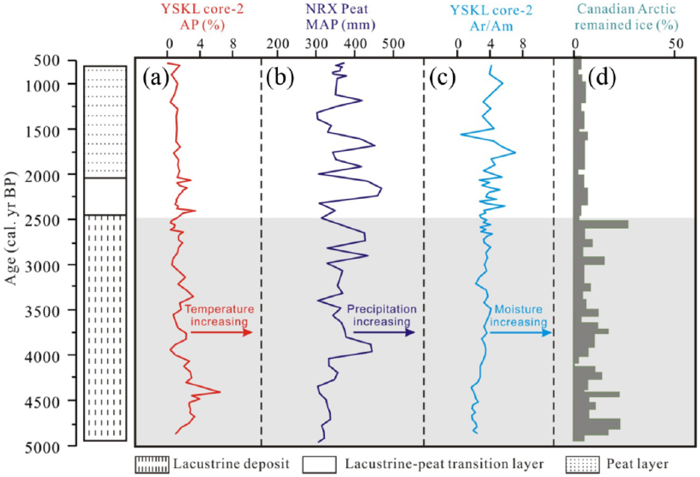
Environment changes in the southern Altai Mountains and the possible driving mechanism. (a) AP% ratio from YSKL core-2 (this study). (b) Mean annual precipitation (MAP) from Narenxia (NRX) Peat (Feng et al., 2017). (c) Artemisia/Amaranthaceae (Ar/Am) ratio from YSKL core-2 (this study). (d) Areal extent of the remaining ice covers in Arctic Canada (Koerner and Fisher, 1990).
Conclusion
The pollen data of YSKL core-2 show two major vegetation stages in YSKL Peat area and the surrounding areas during the data-covering period. During the stage lasting from ~4870 to ~2550 cal. yr BP, regional vegetation is dominated by desert steppe and local vegetation in YSKL Peat is characterized by Artemisia-dominated mountain steppe. During the stage lasting from ~2550 to ~700 cal. yr BP, regional vegetation is characterized by Artemisia-dominated steppe and local vegetation in YSKL Peat is characterized by Cyperaceae-dominated wetland herbs.
The comparison between the Ar/Am ratio-indicated moisture variation from YSKL core-2 and the pollen-based moisture reconstructions from nearly sites suggests that the moisture change in YSKL Peat area was coincident with that in the referenced sites of southern Altai Mountains and all of the moisture sequences are characterized by a moisture increasing trend during the past ~5000 years.
The regional wetting trend during the past ~5000 years in the southern Altai Mountains and the surrounding areas can be explained by the increasingly enhanced effective soil moisture resulted from the combined effects of decreased temperature and increased precipitation. The contradiction between the increasing trend of regional moisture and the lake paludification-indicated drying (probably warming) trend in YSKL Peat can be explained by invoking the variations in the areal extent of ice covers in the Altai Mountains.
Footnotes
Acknowledgements
We acknowledge ESA and the ESA Globcover 2005 Project, led by MEDIAS France for their help in freely supplying Glob-cover map.
Funding
The author(s) disclosed receipt of the following financial support for the research, authorship, and/or publication of this article: This research was financially supported by Chinese Natural Science Grants (No. 41771234).