



Abstract
The Baodun Culture (4600–3700 a BP) is currently the earliest archeological culture found at the Chengdu Plain in southwestern China. Archeological evidence has shown that the Baodun Culture likely originated from the upper reaches of the Minjiang River, with two possible routes for human migration into the lower Chengdu Plain proposed: (1) At about 5000 a BP, favorable climatic conditions in the upper reaches of the Minjiang stimulated the growth of populations and the development of agriculture in the region. Due to this shift, some groups expanded from the upper Minjiang River to sites in the northern area of the Chengdu Plain, such as the Guiyuanqiao site; (2) during 4800–4300 a BP, a drying event occurred in the upper regions of the river valley causing a reduction in agricultural harvests and the migration of populations into sites – including the Baodun site – from this area of the Minjiang to the southwest piedmont of the Chengdu Plain. A multi-facetted study of the T3321 profile at Baodun site, including pollens, grain size, and geochemistry, demonstrates that after 6000 a BP, the climate of the Chengdu Plain shifted from cool, toward warmer and dryer conditions. However, as the Chengdu Plain is located in an alluvial fan, hydrothermal conditions here are still generally better than those in the upper reaches of Minjiang River. A change in the proportion of Concentricystes seen in the profile T3321 also indicates that after 4700 a BP, the lake and marsh areas associated with the Baodun site further decreased. However, as a result of this reduction, more terrestrial surfaces were exposed, providing favored space for Baodun Cultural groups in the area of the site. Due to such conditions, by about 4600 cal. a BP, people in the upper reaches of the Minjiang River had primarily moved to the southwest piedmont regions of the Chengdu Plain.
Keywords
Introduction
The relationship between human activities and environmental changes is one of the hot topics in academic research. Studies have shown that the prosperity and decline of many early civilizations and the migration of populations are highly influenced by the change of natural environment (deMenocal et al., 2000; Weiss, 2000; Weiss and Bradley, 2001). For instance, the decline of Maya civilization in Central America may be related to the aridification and the subsequent reduction of precipitation (Kuper and Kröpelin, 2006; Medina-Elizalde and Rohling, 2012). The genesis and disappearance of ancient civilizations in the regions of Mesopotamia, Nile, and India have also been regarded as a close relation with the multiple climate fluctuation events that occurred in the Holocene (Clarke et al., 2016; Cullen et al., 2000; Marshall et al., 2011; Robert, 1999; Staubwasser et al., 2003; Staubwasser and Weiss, 2006; Welc and Marks, 2014). In China, a significant amount of archeological research in the Yangtze River confirms the close relationship between the prosperity and decline of civilization and environmental changes (He et al., 2018; Jia et al., 2017; Li et al., 2014; Wu et al., 2014, 2017; Zeng et al., 2016; Zhu et al., 2016). Increasing evidence from the Yellow River also indicates the positive relationship between the expansion and decline of Neolithic cultures and climatic change and agricultural development in the Holocene (Bai et al., 2017; Dong, 2013; Hou et al., 2009; Li et al., 2015).
The Chengdu Plain is located in the west of the Sichuan Basin and along the southeast edge of the Tibet Plateau. The plain rises to an elevation of 400–750 m and covers an area of ~8400 km2. It was formed by rivers originating from the Longmen Mountain and the Chuanxi plateau and is the largest fluvial plain in southwestern China (Liang et al., 2014). The suitable climate of the Chengdu Plain attracted earlier populations who occupied the area. Since the 1980s, several ancient cities assigned to the late Neolithic have been discovered. Consensus has been reached regarding the age and cultural attribute of these archeological remains, with archeologists identifying what they have termed the Baodun Culture (Jiang et al., 2002). According to the C14 dating, the upper limit of the Baodun site, which is the type site for the Baodun Culture, has been dated to 4600 a BP, while the lower limit is 3700 a BP. The latest archeological data show that the Baodun Culture can be divided into five chronological stages: the first stage is from 4600 to 4500 a BP, the second stage is from 4500 to 4300 a BP, the third stage is from 4300 to 4100 a BP, the fourth stage is from 4100 to 3900 a BP, and the fifth stage is from 3900 to 3700 a BP (Department of Archaeology, Sichuan University et al., 2018). Regardless of its recognition as a culture in the Chengdu Plain, there is still extensive discussion regarding the origins of the Baodun Culture. Archeological evidence supports the theory that the Baodun peoples originated from the upper valley of the Minjiang River in western Sichuan Province, and then absorbed the cultural elements from adjacent regions (Chen, 2007; Chen et al., 2004; He, 2016; Jiang, 2004).
However, due to the limited study, our knowledge regarding the details of why and how these people migrated from the Minjiang River to the low attitude Chengdu Plain is still unclear. A favored explanation is that environmental changes may have influenced cultural migration and dispersal, particularly during the prehistoric period (Cullen et al., 2000; Haug et al., 2003; Welc and Marks, 2014; Wu et al., 2017; Wu and Liu, 2004). Our study aims to identify the paleo-environmental factors in this context and the direct and/or indirect role the environment and changing climates played in the origin of the Baodun Culture. At the same time, on the basis of archeological research, it provides more direct evidence of natural environment for the evolution of Baodun Culture. With this in mind, stratigraphic samples used for environmental analyses in this case were collected from the T3321 profile of Baodun site.
The Baodun site and its age
The Baodun site is located in Baodun village, Xinping town, which is ~5 km northwestern of Xinjin county, Chengdu city, Sichuan Province (Figure 1). The site’s coordinates are E103°45′, N30°26′, and it rests at an elevation of 472–474 m. In terms of location, the site is about 4 km to the Xihe River in northeast and approximately 500 m to the Tiexihe River in southwest. In general, the site belongs to the subtropical humid monsoon region, which is characterized by less sunshine and wind, but heightened precipitation and humidity. The annual average temperature is 17°C, and the annual total precipitation is about 1000 mm with rainfall concentrated during the months of July and August (Liang et al., 2014). The site of Baodun is currently the biggest prehistoric site that characterizes this culture and in 2009, an outer site wall covering an area of 2.76 km2 was also found at Baodun (Chengdu Institute of Cultural Relics and Archaeology and Heritage Management Office of Xinjin, 2011). Equally important, the site of Baodun can be regarded as a representative site that demonstrates evidence for the early stage of the Baodun Culture. The most recent dating results support the view that the site represents the earliest development of this culture (Joint Archaeological Investigation Team Between China and Japan, 1998).

Location of the Baodun site and additional major Neolithic sites in Western Sichuan. 1. Baodun site (Sampling site); 2. Guiyuanqiao site; 3. Xiaguanzi site; 4. Shawudu site; 5. Yingpanshan site. Most of the early sites of Baodun Culture (points marked in orange) were distributed in the mountain front, it is speculated that the population in Baodun Culture period may have originated from the mountainous area in the upper reaches of Minjiang River.
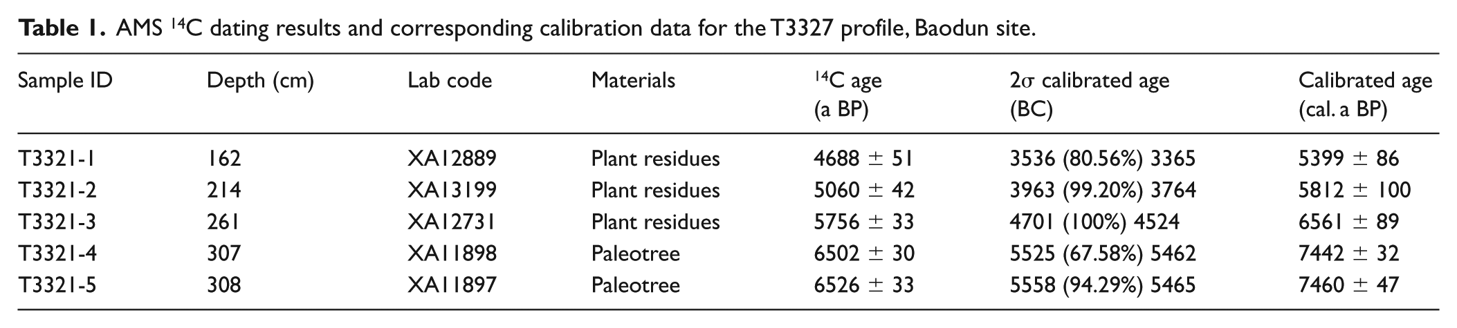
In total, five samples containing wood and other plant remains were used for C14 dating carried out in the AMS lab of the Institute of Earth Environment, Chinese Academy of Sciences. Samples were collected from layers featured by the Baodun Culture (details about the site stratigraphy are provided in the following section). Calibration using the software of Calib Rev 7.0.4 software (Stuiver and Reimer, 1993) provided individual ages from layer 9 to layer 13 (Table 1). These dates include 5399 a BP for layer 9, 5812 a BP for layer 10, 6561 a BP for layer 12, and 7442 a BP and 7460 a BP for layer 13. However, it is necessary to point out that the age for layer 9 is older than the estimated age based on archeological research at the site. In layer 9, researchers have excavated a large number of ceramic pots belonging to the Baodun Culture. The results of C14 dating indicate that the age of these pottery deposits is roughly 4600–4300 years (Table 2). This indicates that people lived at the site during this period, and thus the plant remains used for dating from layer 9 is likely a mixture from older deposits that have resulted from human activities. Linear interpolation and extrapolation analysis using four dating results from layers 10, 12, and 13 deduce an age of 4654 a BP for layer 9. The correlation coefficient is 0.99, which indicates the reliability of the dates (Figure 2c). Overall, taking into account the range of error for these dates, layer 9 can be estimated to be 4600–4300 a BP.
AMS 14C dating results and corresponding calibration data for the T3327 profile, Baodun site.
Statistics of 14C dating results in other areas (the same layers as the ninth layer of this paper) of Baodun site.


Ancient site wall of the Baodun site and the profile for collecting samples: (a) Plan and sampling location of Baodun site, (b) sampling profile (T3321) photo (there are 13 layers in the profile, the stratum studied in this paper is 9–11 layer), and (c) lithology characteristics and age of T3321 profile.
Due to the early age of the Baodun site, investigating environmental changes at the location can help us understand some of the adaptive strategies developed by Baodun populations as well as potential relationships between regional environmental changes and the origins of the Baodun Culture at the site and, more broadly, in the Chengdu Plain.
Materials and methods
Sediment and sampling
Samples were collected from the T3321 profile of the Baodun site (Figure 2a). According to the changes demonstrated in the site’s stratigraphy, the profile can be divided into 13 layers, with a total depth of 308 cm (Figure 2b). Based on archeological materials associated with Layers 1–9, from 1 to 9 these are assigned to the Han dynasty. The focus of the present study are layers 9–11, which contain evidence for the Baodun Culture and its relationship with the environment. Layer 9 (150–200 cm) consists of grayish-brown sandy clay with rich manganese nodules. This stratum is widespread across the entire site and is a natural stratum formed by lake and marshland environments. Archeological material includes abundant pottery. Layer 10 (200–214 cm) is a grayish yellow silty clay layer, along with a small amount of Ferrum (Fe) and Manganese (Mn) films. Layer 11 (214–230 cm) is characterized by yellow silty clay. Samples were collected at intervals of 2 cm between 150 and 230 cm. Each sample was 1 cm in thickness, and a total of 27 samples were obtained. The age of these samples was dated to ca. 6000–4300 a BP, as described above.
Pollen analysis
Each sample extracted for pollen analysis weighed 50–60 g. All samples were combined with Lycopodium spores (27,560 grain/per tablet) in order to calculate pollen concentrations before acid-alkali treatment (Fægri et al., 1989). In total, at least 300 pollen grains per sample were identified and counted using a ZEISS microscope at a 400× magnification. Identification of pollen and spores were made with reference to modern and Quaternary atlases (Tang et al., 2016; Wang et al., 1995). We used Tilia software, version 2.0.4 (Grimm, 2004) to process pollen data and construct associated diagrams. Data connected to non-aquatic pollen were analyzed using constrained cluster analysis and was processed by CONISS. The ratio of AP/NAP (arboreal pollen/non-arboreal pollen) can reflect vegetation types in the region and is an important indicator of forest coverage (Chen et al., 2014; Deng et al., 2002; Ling et al., 2016). Principal component analysis (PCA) was performed using Canoco 4.5 Software (Ter Braak and Smilauer, 2002). The identification of pollens and spores was conducted at the Institute of Hydrogeology and Environmental Geology, Chinese Academy of Geological Sciences.
Grain size
Grain size distribution was analyzed using a hydrometer (Lewis, 1984; Xu, 1992). Grain size was determined using a Malvern Mastersizer 2000 laser grain size analyzer. Before measuring, the samples were pretreated with H2O2 and HCl to remove organic matter and carbonate, and then treated with (NaPO3)6 solution to disperse ultrasonically (Lu and An, 1998). The experiment was carried out at the School of Geography and Marine Science, Nanjing University.
X-ray fluorescence analysis
There are significant differences in geochemical behavior between Rubidiu (Rb) and Zirconium (Zr) in the epigenetic geochemical environment. Rb is relatively enriched in fine particles such as clay, while Zr is relatively concentrated in coarse-grained sediments. In general, when chemical weathering is strong, the content of fine particles in sediments is high, and the ratio of Zr/Rb is low, and vice versa (Chen et al., 2003; Liu et al., 2002). We used a PW-2403 x-ray fluorescence spectrometer to test the contents of Rb and Zr elements in the samples. The experiment was carried out in the Key Laboratory of Western China’s Environmental System, Ministry of Education, Lanzhou University.
Results
Pollen analysis
A total of 88 pollens were identified. Trees and shrubs accounted for more than 50% of the sample. According to the nature of the sediment and cluster analysis of pollens using Tilia CONISS software, the depth of 150–230 cm in the T3321 profile can be divided into three pollen zones (Figure 3). The details of each zone – from bottom to top – are described below.
Zone 1 (230–203 cm, 6000–5500 cal. a BP). This zone was characterized primarily by a high proportion (84.7%) of trees and shrubs, which was dominated by Pinus (57.7%), Betula (6.3%), and deciduous Quercus (5.6%). The proportion of upland herbs was 15.3% and composed mostly of Poaceae (8.0%) and Artemisia (2.5%). The proportion of ferns was approximately 90% and the proportion of Concentricystes is more than 30%.
Zone 2 (203–170 cm, 5500–4700 cal. a BP). The proportion of trees and shrubs (69.7%) was lower than that of the Zone 1. Pinus (25.4%) and Betula (1.6%) also decreased significantly. The Carpinus (6.7%), Liquidambar (8.9%), Apocynaceae (6.1%), and Corylus (7.6%) appear first in this zone and continue to increase. The proportion of upland herbs is 30% and is comprised mainly of Poaceae (10%), Ranunculaceae (5.8%), and Solanaceae (4.5%). The proportion of ferns remained high (78.2%) and the Concentricystes was further increased to 47.5%.
Zone 3 (171–150 cm, 4700–4300 cal. a BP). In this stage, the proportion of upland herbs (45.8%) increased significantly, reaching the highest proportion throughout the profile. Pollen types also increased, mainly Poaceae (13.2%), Aster (4.4%), Caryophyllaceae (4.7%), Rosaceae (4.0%), Convolvulaceae (3.9%), and Taraxacum (3.5%). The proportion of trees and shrubs decreased to 54.2%. The proportion of Pinus (19.6%), Liquidambar (1.3%), Apocynaceae (1.1%) and Corylus (2.6%) decreased, while the proportion of deciduous Quercus (7.2%) increased. The proportion of ferns decreased to 70%, and the number of Concentricystes (12.6%) decreased significantly at this stage.
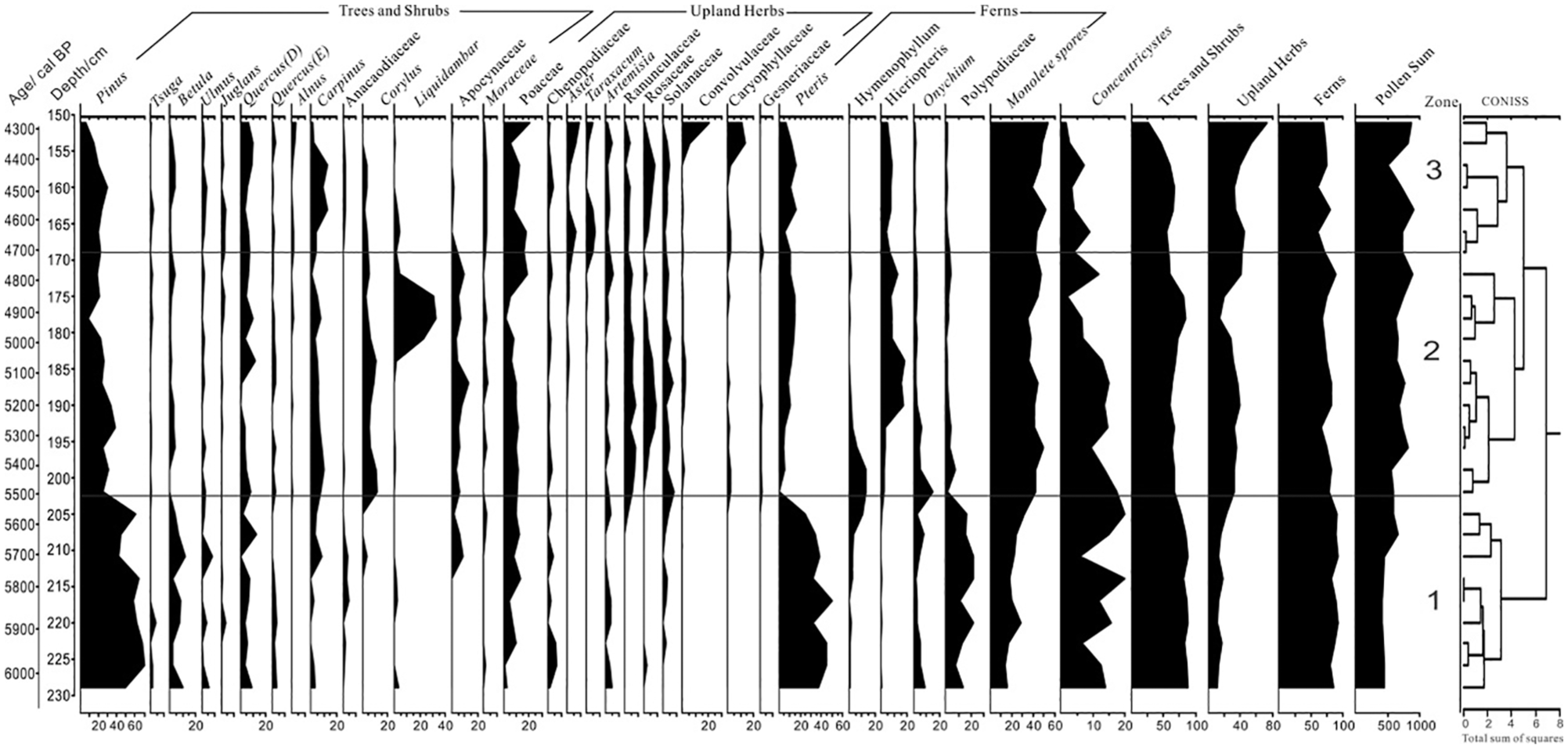
Simplified pollen percentage diagram of the T3321 profile of the Baodun site calibrated radiocarbon age ranges before present (cal. a BP) are shown on the left of the diagram. Three main pollen zones are obtained from a constrained cluster analysis and shown on the right of the diagram.
A total of 31 major pollen taxa (minimum percentage > 2%) was used for PCA analysis. Figure 4 shows that the first (PCA1) and second (PCA2) principal components account for 60.8% and 20.7%, respectively, of the total pollen taxa. Trees and shrubs (e.g. Pinus, Betula, Anacaodiaceae) and upland herbs (e.g. Chenopodium, Poaceae, Ranunculaceae, Rosaceae, and Solanaceae) show a positive trend along PCA axis 1. Wetland herbs (e.g. Cyperaceae, Urticaceae, Gesneriaceae) mainly demonstrate a negative distribution in PCA axis 1. Therefore, PCA1 could be interpreted as depicting an indicator of precipitation/moisture availability (Fall, 2012; Gignac et al., 2004). In particular, positive values indicate dry conditions and negative values indicate wet conditions.

Bi-plot of a PCA of fossil pollen data (>2% in at least one sample) from the T3321 profile at the Baodun site.
As depicted in Figure 4, cool-resistant plant (e.g. Tsuga, Pinus, Viburnum) pollen types are associated with the negative value on PCA axis 2 and warm-climate woody (e.g. Liquidambar, Alnus) pollen are represented by the positive values on PCA axis 2. However, Quercus (Evergreen), Quercus (Deciduous) pollen and cold-resistant types are distributed in the same direction of the PCA2 axis. In general, this pattern shows that axis 2 can be used as an indicator of temperature, but with the caveat that it may be affected by factors of precipitation/moisture (Cui et al., 2018). Give these patterns, vegetation at the site may be more sensitive to such indicators.
Analyses of particle size and Zr/Rb ratio
The results of 27 samples show that the average particle size of the sediment is between 5 and 6 Φ, and the particles are mainly silt (Table 3). Sedimentary changes can be divided into three stages, which correspond positively with the pollen assemblages and the Zr/Rb ratio (Figure 5).
Stage 1 (230–203 cm, 6000–5500 cal. a BP). At this stage, the average grain size of the sediment is large (5.5 Φ), and the proportion of sand is 24%. The Zr/Rb ratio shows a large to small change at this stage, with an average of 3.2 Φ.
Stage 2 (203–170 cm, 5500–4700 cal. a BP). The average particle size (5.9 Φ) and the proportion of sand (17.1%) decrease, and the proportion of clay (5.9%) and silt (18.7%) increase, representing the highest value of the entire profile. The Zr/Rb ratio (3.1) shows a small to large change and demonstrates the minimum of this ratio of the total profile.
Stage 3 (170–150 cm, 4700–4300 cal. a BP). At this stage, the average particle size (5.6 Φ) increases, the proportion of sand also increases to 23.7%, and the proportion of clay (5.6%) and silt (16.1%) decrease. As illustrated on Figure 5, the curve fluctuates greatly, indicating that hydrodynamic power enhances and becomes unstable. An increase in the Zr/Rb ratio (3.6) also implies an increase in coarse particle deposits. This stage corresponds to the upper portion of the ninth layer and is still characterized as a shallow water marsh sedimentary environment.
Variations of the grain size of the T3327 profile in Baodun site.


Variations of the grain size and Zr/Rb of the T3321 profile in Baodun site.
Discussion
Environmental changes of 6000–4300 cal. a BP in Baodun Site
Concentricystes fossils are the remains of a type of algae that are highly adaptive to climatic variation and are widely distributed in the Quaternary strata of China. This type of fossil occurs primarily in lake and marsh sediments. They usually reflect warm and humid climatic environments and can be traced back to prehistoric environmental changes that lead to freshwater lakes and marshes in the region (Tang et al., 2013). Comparing the Zr/Rb ratio; average sediment size; AP/NAP, PCA1, and PCA2 results; and the number of fossils of Concentricystes (Figure 6), palaeoenvironmental changes since 6000–4300 cal. a BP at the Baodun site can be divided into three stages.
Stage 1 (230–203 cm, 6000–5500 cal. a BP). PCA1 (average 1.48) and PCA2 (average –0.66) are indicators of precipitation/moisture and temperature, respectively, showing a roughly opposite trend at this stage, indicating that the climate at the Baodun site may have experienced a shift from cold-dry to warm-wet. The Zr/Rb ratio shows a change from high to low, suggesting that the climate is trending toward more warm and humid conditions. The AP/NAP ratio (3.71) is the highest value of the profile, indicating that forest coverage in the study area was large. Concentricystes increased gradually and were at their highest frequency of all stages, suggesting that the presence of lakes and marshes in the site area were at their maximum during this period. The average sediment particle size (5.5 Φ) is large, indicating that hydrodynamics is strong. This stage corresponds to layers 10–11, which differ from the river sediments that characterize layers 12–13. It is speculated that at this stage, the river system changed gradually and evolved into a sedimentary environment of flood plains in association with lake and marsh biomes.
Stage 2 (203–170 cm, 5500–4700 cal. a BP). The ratio of Zr/Rb showed a change from low to high, PCA1 (average 0.30) values decreased, and PCA2 values (average 1.22) increased. The proportion of upland herbs was 30%, indicating that the climate changed from warm and humid to relatively warm and dry. The AP/NAP ratio (1.95) decreased, reflecting a reduction in the extent of forests. The proportion of Concentricystes decreased gradually, indicating that lakes and marshes in the study area was greatly reduced. The average particle size (5.9 Φ) decreased and silt and clay increased, suggesting a weakening of hydrodynamic force. This stage corresponds to layer 9 where sediments are grayish brown in color, indicating that organic matter content is relatively high. It is speculated that this layer was likely a sedimentary environment related to a shallow water marsh, and the sedimentary source is relatively stable.
Stage 3 (170–150 cm, 4700–4300 cal. a BP). At this stage, the Zr/Rb ratio increased, PCA1 value decreased to 0.12, and PCA2 value increased to 1.26. The proportion of upland herbs (45.8%) reached its maximum frequency in the entire profile. It reflects that the climate in the study area was warmer and drier. The AP/NAP ratio decreased to 1.08, suggesting a further decrease in forest cover. The proportion of Concentricystes fossils decreased to its lowest in the profile, reflecting the further reduction of the lake system. The average particle size (5.6 Φ) and the proportion of sand increased, suggesting hydrodynamic enhancement. This stage corresponds to the upper portion of layer 9, which is still a shallow-water marsh sedimentary environment. The increase of coarse-grained sediments may be related to the increase of sudden floods. Evidence indicates that ancient floods occurred in the site area (Chengdu Institute of Cultural Relics and Archaeology and Heritage Management Office of Xinjin, 2011; Huang, 2013).
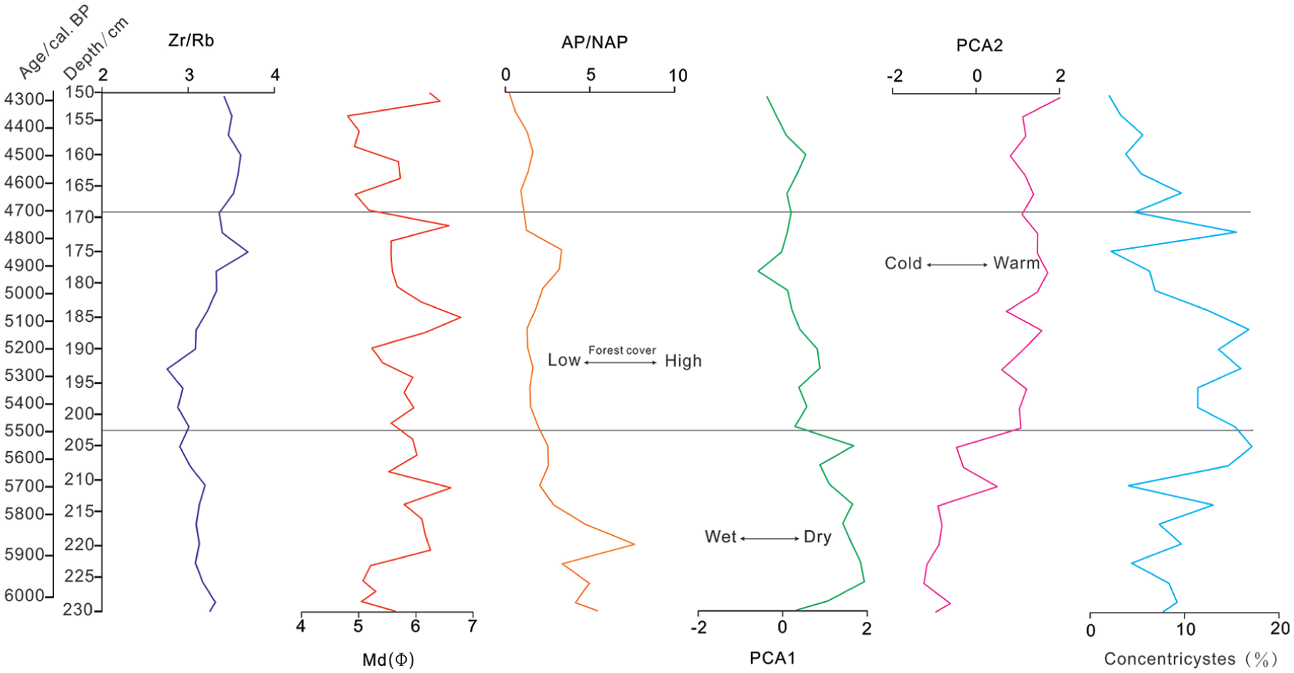
Comparison of multiple alternative environmental indicators of the T3321 profile in Baodun site.
Later in stage 3, evidence for human activities in the region begins to emerge. In particular, changes in pollen reflect the possibility of human impact on the local environment and processes of transformation. Pollen from trees and shrubs is still dominant, but pinus decreases significantly (Figure 5), possibly due to deforestation caused by human clearing. Pollen of poaceae dominated by upland herbs increased significantly, due to two possible factors: on one hand, it may reflect that the climate is still relatively dry at this stage, on the other hand, it may be related to human activities. Poaceae, Solanaceae, Convolvulaceae, Cruciferae, Rosaceae, and other herbaceous pollens are anthropophyte pollens and are related to cultivated crops (Li et al., 2008). Plant-related archeological evidence shows that the main crop combination at the Baodun site is a rice-millet mixed cropping (Chen et al., 2015; Jiang et al., 2011; Shi et al., 2015; Yan et al., 2015). Therefore, these pollens increased or began to appear at this stage, which may be closely related to agricultural planting activities during the Baodun cultural period.
Archeological evidence of the origin of Baodun Culture
The Minjiang River is an important tributary of the upper reaches of the Yangtze River, which lies between the eastern margin of the Qinghai-Tibet Plateau and the Sichuan basin. The upper reaches of the Minjiang River have historically been the intersection of the two cultures of the upper reaches of the Yangtze River and the upper reaches of the Yellow River (Jiang and Chen, 2001). The typical sites of Neolithic Culture Period found in the upper reaches of Minjiang River (such as Yingpanshan site, Xiaguanzi site, Shawudu site; Figure 1) were mostly between 5500 and 4000 a BP, and their cultural characteristics were similar to Majiayao Culture. Majiayao Culture is an important Neolithic culture type in Gansu-Qinghai area of the upper Yellow River, which is divided into three types (Yang, 1962). They are Ma jiayao type (5300–4800 a BP), Banshan type (4500–4300 a BP), and Machang type (4300–4000 a BP). Archeological studies (He, 2016) suggest that the Baodun Culture probably originated mainly from the upper reaches of the Minjiang River and absorbed the cultural factors of the surrounding areas.
Examining specific traits – both morphological and decorative – can help us to understand possible cultural relationships between different sites and have been used widely in Chinese archeology (Gao and Shao, 1981; Wang and Qu, 2018; Zhang, 1983). Comparing pottery unearthed from the sites of Yingpanshan, Xiaguanzi, and Shawudu (Figure 7) in the upper reaches of Minjiang River, it is possible to identify similarities with the Baodun Culture on the Chengdu Plain. Xiaguanzi site has some Baodun Cultural characteristics, but more of them inherit more Majiayao Cultural characteristics, and the upper limit of its age is earlier than Baodun Culture. The general characteristics of pottery at Shawudu site are more similar to that of Baodun Culture, which is about the same period as that of Baodun Culture. Due to these shared traits, it is possible that the material culture from these three sites is related to Baodun Culture. Of the three, Xiaguanzi site is closest in age to Baodun Culture and therefore, Xiaguanzi site may be its direct source (He, 2016).

Variations in pottery between Baodun cultural sites and those in the upper reaches of Minjiang River. The ceramics unearthed at the Baodun site include specimen numbers T1929⑧: 126 (specimen number, the same below), T2129⑥: 38, T2130⑦: 49, T2130⑦: 76 (Sino-Japanese joint archeological investigation team, 1998), T1630⑦: 63 (Department of Archeology, School of History and Culture, Sichuan University, 2018), WT2Q4: 6 (Chengdu Institute of Cultural Relics and Archeology and Heritage Management Office of Xinjin, 2011); Ceramics recovered from the Yingpanshan site include T6③: 36, H7: 1 (Chengdu Institute of Cultural Relics and Archaeology et al., 2002), 03H58:6 and 03H36:21 (He, 2016). The pottery unearthed at the Xiaguanzi site includes T1④: 82, T1④: 86, and T1④: 46 (Chengdu Institute of Cultural Relics and Archeology et al., 2008). Ceramics from the Shawudu site include H1: 2, H1: 4, and H1: 7 (Chengdu Institute of Cultural Relics and Archeology et al., 2006). Finally, ceramics from the Guiyuanqiao site include TN07E084: 3 (Wan and Lei, 2013), H29: 5, T12⑤: 9 (Sichuan Provincial Institute of Cultural Relics and Archeology et al., 2013).
The Guiyuanqiao site is the oldest in Chengdu Plain (Sichuan Provincial Institute of Cultural Relics and Archaeology et al., 2013; Wan and Lei, 2013). This site can be divided into three phases. The pottery (such as TN07E08④: 3) associated with the first phase (5100–4600 a BP) of the site is similar to the Yingpanshan site (such as 03H36: 21). The pottery (such as H29: 5, T12⑤: 9) recovered from the second phase (4600–4300 a BP) of Guiyuanqiao site demonstrates shared traits with the Baodun Culture (such as T2130⑦: 76, T1929⑧: 126).
It is speculated that people from Guiyuanqiao may have originated from Yingpanshan site. In this case, they would have been influenced by Baodun Culture during the second phase of their development. Due to this, the discovery of the Guiyuanqiao site further supports the premise that the direct source of Baodun Culture may have come from the upper Minjiang River region.
Population migration and paleoenvironment between the upper reaches of Minjiang River and the Chengdu plain
The Guiyuanqiao site is older than Baodun cultural sites and is located in the northwest of the Chengdu Plain, while early sites associated with the culture are primarily distributed in the southwestern edge of the plain (Figure 1). It is speculated that in the late Neolithic Era, there may have been two human migrations from the upper reaches of Minjiang River to the Chengdu Plain: one from the upper reaches of Minjiang River to the northern part of Chengdu Plain occurring about 5100 a BP and would include sites such as Guiyuanqiao. The other migration is suggested to have taken place from the Minjiang River toward the southwestern edge of Chengdu Plain about 4600 a BP and would have included sites such as Baodun and Gaoshan. The two migrations may have led to the emergence and development of the Baodun Culture in the Chengdu plain.
Population migration and paleoenvironment around 5100 a BP
Suitable climatic conditions can promote the prosperity of ancient culture and the expansion of the population (Binford et al., 1997; Cremaschi and Zerboni, 2009; Dong et al., 2017a). Evidence indicates that the first large-scale cultural expansion of the Neolithic era in the Gansu-Qinghai region occurred during the Majiayao period (5300–4800 a BP) (Dong et al., 2013; Jia, 2012; Jia et al., 2012). Environmental indicators in the upper reaches of the Yellow River show that the climate in the Gansu-Qinghai region was relatively humid around 5000 a BP (Figure 8) (Bai et al., 2017; Cai et al., 2010, 2012) and may have been related to the gradual increase of monsoonal precipitation around 5430 a BP in the western Loess Plateau (Bai et al., 2017). The dissemination and diffusion of crops is also an important aspect of prehistoric cultural exchanges (Dong et al., 2017b; Jones et al., 2011; Jones and Liu, 2009). Increased precipitation may have contributed to the development of rain-fed dry-land millet agriculture during the Majiayao cultural period (d’Alpoim Guedes et al., 2013; Jia et al., 2012; Zhao, 2011), leading to large-scale population and cultural expansion. Botanical archeological evidence shows that the Yingpanshan site and the first phase of the Guiyuanqiao site are mainly related to broomcorn millet and foxtail millet production (Sichuan Provincial Institute of Cultural Relics and Archaeology, 2015; Zhao and Chen, 2011). A similar pattern is seen during the Majiayao cultural period in Gansu-Qinghai area. The first phase of occupation at Guiyuanqiao is close to the Yingpanshan site in age, and its pottery combination reflects the cultural characteristics and plant archeology reflects the living pattern and is relatively similar. Therefore, the initial stage of Yingpanshan site and the Guiyuanqiao site may be related to the large-scale expansion of the Majiayao Culture; this being facilitated by suitable climatic conditions at approximately 5100 a BP in the Gansu-Qinghai area.
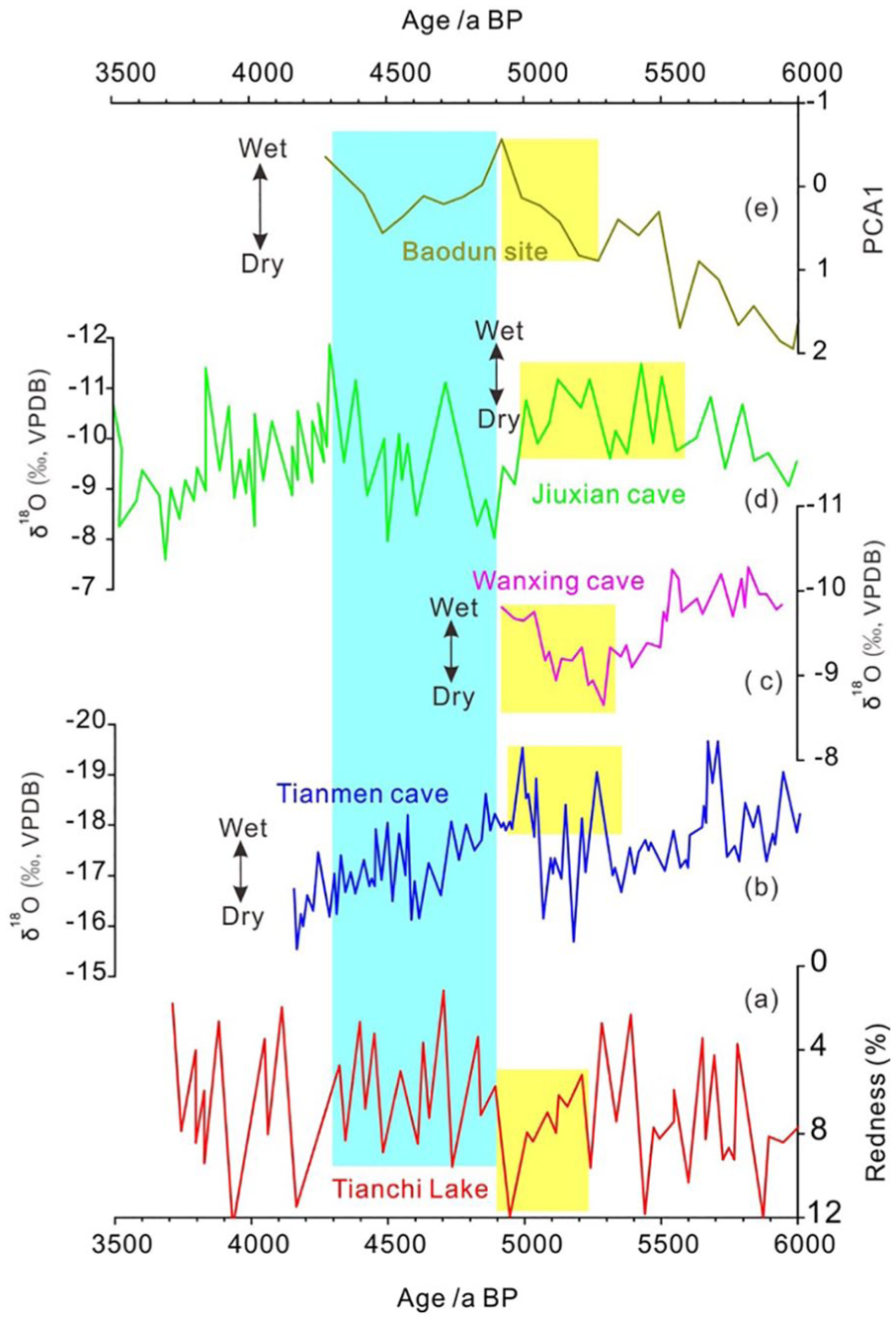
Paleoenvironment contrasts between the Baodun site and sites associated with the upper reaches of the Yellow River: (a) Redness extent of lake core sediments in Liupan Tianchi Lake (Zhou et al., 2010); (b) δ18O values from Tianmen cave TM-18 stalagmite, Qinghai-Tibet Plateau (Cai et al., 2012); (c) δ18O values from Wanxiang cave XB07-4 stalagmite stalagmite, western Loess Plateau (Bai et al., 2017); (d) δ18O values from Jiuxian cave stalagmite (Cai et al., 2010); (e) Pollen PCA1 value of T3321 profile of Baodun site (this article). The vertical yellow bands trace the relatively humid periods. The vertical blue bands trace the relatively drought periods.
Population migration and paleoenvironment around 4600 a BP
Adverse climatic conditions may be an important environmental factor for the decline of ancient culture and may also promote the large-scale migration of people between regions (Büntgen et al., 2011; deMenocal et al., 2000; Dong et al., 2017b; Kerr, 1998; Weiss et al., 1993). The period between ~4800 and ~4400 a BP reflects a general trough in the Majiayao Culture (Dong et al., 2013). The sediment redness demonstrated on the Loess Plateau of the Tianchi lake (Zhou et al., 2010) and the δ18O values associated with the Jiuxian cave stalagmite (Cai et al., 2010) and the Tianmen cave stalagmite (Cai et al., 2012) of the Qinghai-Tibet Plateau indicate reduced precipitation in Gansu-Qinghai area during this stage (Figure 8). The reduction of precipitation may have had an impact on agricultural activities at that time, resulting in human populations migrating to areas with more desirable hydrothermal conditions. Thus, in general, the change of precipitation may have had a significant impact on agricultural activities of the Majiayao people and its culture (Dong et al., 2013), affecting the rise and fall of various stages of Majiayao Culture. The deterioration of climate and the decline of sites in the area of Gansu-Qinghai during this period may have also affected the upper reaches of the Minjiang River where people began to migrate to areas of lower altitude. The change of PCA1 at the Baodun site also shows that the climate at the Chengdu Plain indicates a trend toward increased drying during 4800–4300 a BP. However, due to a geomorphological environment that is represented by its alluvial fan, in the Chengdu Plain, the hydrothermal conditions are still better than those in the upper reaches of the Minjiang River. Due to this climatic pattern, the drought that occurs between 4800 and 4300 a BP may have prompted people in the upper reaches of the Minjiang to migrate to the southwest of the Chengdu Plain where more suitable hydrothermal conditions existed.
As illustrated in Figure 1, it can be seen that the sites that encompass the Baodun Culture during the early period of its existence (4500–4000 a BP) were primarily concentrated in the piedmont area of Southwest Chengdu Plain. On the contrary, Baodun Cultural sites in the late period tended toward the hinterland of the plain, which may be related to the environmental adaptation of ancient populations from the mountains to the plains. To begin with, people could not adapt to the watery environments of the hinterland of the plain, so the plain piedmont might have been the better choice. A change of the frequency of Concentricystes in profile T3321 of the Baodun site indicates that the depositional area of the lake and marsh was substantial during the period of 6000–4700 a BP, at which time the area of lake and marsh began to shrink. The shrinkage of the area meant that more platforms were exposed on the surface and terrestrial environments expanded which increased the activity area for resident human groups. At the same time, the existence of lakes and marshes also provided sufficient water for ancient peoples. Archeological excavations also show that the people of Baodun site live essentially around the lake and marsh sedimentary areas (Chengdu Institute of Cultural Relics and Archeology and Heritage Management Office of Xinjin, 2011). Therefore, as represented by the Baodun type site, by about 4600 a BP, people of the early period of Baodun Culture began to live in the piedmont area of Chengdu Plain.
Conclusion
Pollen and geochemical evidence demonstrates that the climate of the Chengdu Plain shifted from cool to warmer and dryer conditions during 6000–5500 cal. a BP. The climate grew warmer and drier during 5500–4700 cal. a BP period, and warmer and drier trend further intensified during 4700–4300 cal. a BP period. Sediments and a change in the frequency of Concentricystes indicate that during 6000–5500 cal. a BP, the main sedimentary environments at Baodun were characterized by floodplain and lake-marsh facies, and that during the period of 5500–4700 cal. a BP, the main sedimentary environments were solely lake-marsh facies, but with the area of lakes and marshes gradually decreasing. During 4700–4300 cal. a BP, the main sedimentary environments of Baodun site continued to be mainly lake-marsh facies but with such areas continuing to reduce in size.
Archeological evidence shows that the Baodun Culture may have originated in the upper reaches of the Minjiang River. Moreover, there may have been two migration routes between the upper reaches of the Minjiang and the Chengdu Plain during the late Neolithic. In the Majiayao stage (5300–4800 a BP), suitable climate conditions in the region of Gansu -Qinghai promoted increased agricultural activities and related population growth, with the Majiayao Culture seeing significant large-scale expansion. Under such circumstances, at about 5100 a BP, people in the upper reaches of the Minjiang River migrated to the site of Guiyuanqiao in the northern region of the Chengdu Plain.
The drought-like conditions in Gansu-Qinghai area between 4800 and 4300 a BP may have had a major impact on people residing in the upper reaches of the Minjiang River and lived predominantly by the drought-fed agriculture. Although paleoenvironmental evidence (as seen in the topographic traits of the Chengdu alluvial fan) of the Baodun site indicates that the climate of the Chengdu Plain had dried up during this period, hydrothermal conditions were still generally better than those in the upper reaches of Minjiang River. Baodun is typical of the early sites of the Baodun Culture in the Chengdu plain. After 4700 cal. a BP, although the lake and marsh areas associated with the Baodun site further decreased, as a result, more terrestrial surfaces were exposed, providing increased occupational space for Baodun Cultural groups in the site area. At the same time, the existence of lakes and marshes provided convenient sources of water for agricultural activities. Due to such conditions, by about 4600 cal. a BP, people in the upper reaches of the Minjiang River had begun to live in the southwest piedmont regions of the Chengdu Plain. With an adaptation to a varied, water-rich environment, later Baodun Cultural populations had migrated to the favorable hinterlands of the Chengdu Plain.
Footnotes
Acknowledgements
We sincerely thank Tianhong Guo and Houchun Guan for the assistance in samples collection. We also would like to express our thanks to Dr Hao Li for language polishing and critical reading of the revised manuscript. We are also indebted to the two anonymous reviewers, for their thoughtful critiques and suggestions.
Funding
The author(s) disclosed receipt of the following financial support for the research, authorship, and/or publication of this article: This research was supported by the grants from the National Natural Science Foundation of China (No. 41371204; 41571179) and the National Basic Research Program of China (No. 2015CB953804).
