
Abstract
Multidisciplinary studies in coastal systems of the eastern Mediterranean region have proven to be excellent tools in understanding paleoenvironmental, paleoecological, and paleoclimatic changes that took place during the Holocene period, and how these changes interacted with urban development and growth. This paper presents sedimentological, high-resolution x-ray fluorescence (XRF scanning), micropaleontological, and x-ray diffraction (XRD) data from three shallow sediment cores that were retrieved from Aliki (ancient Siphai or Tipha) salt pond. The study area is located in a unique, highly tectonic geographical region, at the northeast part of the Gulf of Corinth in Greece. Beachrock deposits that form a barrier between the salt pond and the marine environment seem to play an important role in the evolution of the area. The chronological framework was set at around 3100 cal. BP by four 14C radiocarbon dates, and the evolutionary model that was established indicates four different changes taking place during this period at the study area. From around 3100 to 1600 cal. BP, a transition from a closed to an open lagoonal environment was identified, interrupted by a fluvial terrestrial deposit at around 2500 cal. BP. A shift toward a closed lagoonal system at around 1600 cal. BP and the establishment of a salt pond environment seem to correlate with tectonic activity. The study provides important information about the evolution of coastal landscape in such a tectonic active region and points the interaction between regional human activity and climatic changes during the late-Holocene period.
Introduction
The eastern Mediterranean region, featured by combined climate change susceptibility, complex topography, and early cultural development, has long been the center of attention for paleoenvironmental (Avramidis et al., 2014; Brückner et al., 2010; Fouache and Pavlopoulos, 2005; Kouli et al., 2012; Pavlopoulos et al., 2012; Vött, 2007) and paleoclimatic studies that cover the Holocene period (Finné et al., 2011; Gogou et al., 2016; Kaniewski et al., 2013; Katrantsiotis et al., 2018; Luterbacher et al., 2012; Peyron et al., 2013; Roberts et al., 2012; Triantaphyllou et al., 2014). Specifically, coastal depositional environments in Greece and the interpretation of such changes can highlight the impact they have on societal dynamics (e.g. Avramidis et al., 2017; Emmanouilidis et al., 2018; Goiran et al., 2011; Pavlopoulos et al., 2006; Triantaphyllou et al., 2010; Vouvalidis et al., 2010; Weiberg et al., 2016). Considering coastal salt ponds, well-preserved laminations that often occur in the sediment sequence have proven to be excellent archives for the study of runoff, marine overwash and other natural events taking place in the study area (Brooks et al., 2015).
The Gulf of Corinth is a continental rift with extension rates up to 15 mm/yr and is one of the most seismically active regions in Europe (Woessner et al., 2013). The southern footwall of the gulf, which is uplifted (Armijo et al., 1996; Roberts et al., 1993), is bound by three main faults (Psathopyrgos, Helike, and Xylokastro), whereas the northern part is characterized by the presence of smaller antithetic faults (Figure 1). Tsunamis and high-energy events in the gulf are a common phenomenon affecting coastal areas at least once every 19 years (Papadopoulos, 2003; Papathoma et al., 2003). The main factors producing these high-energy events are coastal and submarine landslides taking place mainly at the western part of the gulf (Heezen et al., 1966; Lykousis et al., 2007; Papatheodorou and Ferentinos, 1997), which trigger the energetic movement of water bodies and therefore tsunamis (Galanopoulos et al., 1964; Stefatos et al., 2006; Tinti et al., 2007).
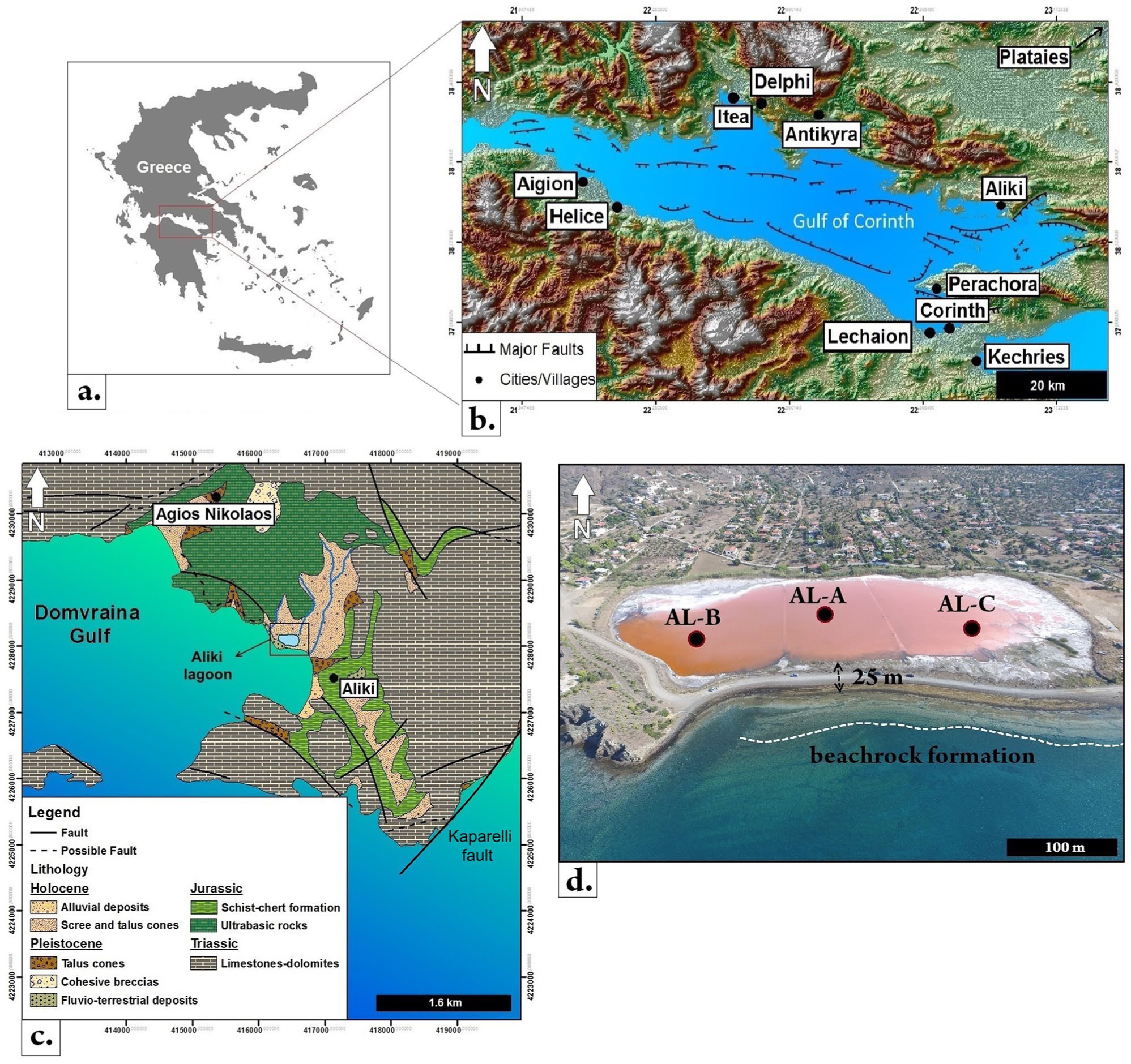
(a) Map of Greece showing the study area, (b) geomorphological map of the Gulf of Corinth with the major faults and cities presented, (c) geological map of the Aliki salt pond and the surrounded area, and (d) cores locations in the salt pond with the beachrock formations.
Through ancient times, societal dynamics along the coastal zone of the Gulf of Corinth were intense and the wider area is known to have been an important trading center with extended human activity. This is indicated by archaeological findings and the ruins of ancient harbors, combined with the paleoenvironmental studies conducted, for example, at the cities of Corinth (Lechaio harbor), Heliki, Aliki, and so on (Hadler et al., 2013; Kolaiti et al., 2017; Kontopoulos and Avramidis, 2003). In such coastal environments, the submerged harbors and settlements have proven to be useful archives in paleoenvironmental reconstruction (Marriner and Morhange, 2007). Also, many catastrophic seismic events that took place in the gulf during the last 2500 years are well documented and coincide with historical reports in the area (Ambraseys, 2009; Ambraseys and Jackson, 1990, 1997; Galanopoulos, 1955; Guidoboni and Comastri, 2005; Guidoboni et al., 1994; Papadopoulos, 2000; Papazachos and Papazachou, 1989, 2003).
The aim of our study is to use a combination of different techniques and carry out a multidisciplinary analysis in order to recognize the different evolutionary stages that occurred in the late-Holocene period, in a coastal area at the north part of the Gulf of Corinth (Figure 1). The results of our study provide detailed information on the coastal development in intensively active tectonic regions as well as potential tectonic and paleoclimatic driving mechanisms that can form and affect such an environment.
Study area
Aliki salt pond is located at central Greece (Figure 1a), at the northeast part of the Gulf of Corinth (Figure 1b) and specifically at the east part of a semi-closed gulf called Domvraina gulf (Figure 1c). The maximum length of Aliki is around 250 m and is constantly changing due to seasonal evaporation and precipitation. The freshwater inflow into the salt pond is only sporadic, since two small streams that flow into the lagoon are mostly dried out as their water is used for agricultural purposes. The typical red color of the salt pond (Figure 1d) is attributed to the presence of the halophile micro-algae Dunaliella salina (Oren, 2005).
The bedrock of the area consists of Triassic Limestones and dolomites (Figure 1c), and in the central and eastern part, Jurassic schist–chert formations and ultrabasic rocks occur (Figure 1c) (Institute of Geology and Mineral Exploration (IGME), 1984). The salt pond is located on a Holocene alluvial deposit and is separated from the sea by a tectonically uplifted (1 m) beachrock barrier with 25 m width (Figure 1d). Beachrocks are formed by carbonate cementation in the intertidal zone and indicate that the formation and evolution of the coastal zone under investigation is controlled primarily by the endogenic processes and, in particular, the neotectonic uplift. Studies conducted in Cyclades, Greece, which used beachrocks as relative sea level indicators, suggest a vertical positional accuracy of +1.0 to ‒5 m (Fouache et al., 2005). In the coastal zone of the study area, the beachrock formations were identified up to 250 m distance from the coast. There are several small step forms between each broad former marine terrace surface. These suggest successive uplift episodes as a result of seismic or coseismic events.
The study area lies on the broadly subsiding flank of the Gulf of Corinth but in the immediate footwall of active normal fault escarpment. The intense tectonic activity affects the area with extensive fault systems. Taking into account the submerged beachrock formations at the coastal zone of Aliki in addition to the submerged ancient harbor that is located at the east part of the Domvraina gulf, the whole area was described to have gone under a coastal subsidence of 1.5 to 2 m (Gaki-Papanastassiou et al., 1996; Vita-Finzi and King, 1985). At the east part, the Kaparelli fault, which extends until the ancient city of Plataies (Figure 1b and c), was described as not active for the last 10 years (Benedetti et al., 2003), but more recent studies provide evidence of younger displacement during the Holocene period (Kokkalas et al., 2007). Additional studies conducted by Hatzfeld et al. (2000) provide further information concerning the seismicity and focal mechanisms in the eastern part of the gulf.
In antiquity, Aliki village was the polis of Siphai or Tipha. Pausanias (1918) writes as follows: Sailing from here you come to Tipha, a small town by the sea. The townsfolk have a sanctuary of Heracles and hold an annual festival. They claim to have been from of old the best sailors in Boeotia, and remind you that Tiphys, who was chosen to steer the Argo, was a fellow-townsman. They point out also the place before the city where they say Argo anchored on her return from Colchis.
The village was supposed to be the birthplace of Tiphys, the helmsman of Argo and one of the Argonauts who accompanied Jason to Colchis (1225 BC). As described from Thucydides in History of the Peloponnesian War (4.76), Siphai was a colony of Thespiae at least from 424 BC and must have played an important role as a trading center through the Gulf of Corinth. Also, the ancient harbor of Siphai, still preserved until today at the eastern part of Domvraina Gulf, and the remnants of the ancient acropolis near the harbor are dated at around the Classical period (479–323 BC). Considering the geomorphological characteristics of Aliki broader area, like the semi-closed and shallow Domvraina Gulf that provided shelter from high hydrodynamic events and could be easily fortified, it is assumed that the area provided an excellent place for early society’s development. Closer to present, the salt pond of Aliki (Figure 1c and d) is known to have been used for salt extraction at least from the Ottoman period in Greece at around AD 1400 and is still used until today by the locals.
Materials and methods
Fieldwork and sampling
For the present study, three sediment cores were retrieved from the Aliki salt pond (AL-A, AL-B, AL-C) (Figure 1c) with the central core AL-A being the longest one (5 m). The cores were extracted using a Russian-type peat corer with 50 cm diameter and then sealed with cling film and transported at the laboratory of Sedimentology, University of Patras, Greece. The exact position of the cores and the beachrock barrier uplift was determined using a Leica differential GPS with vertical and horizontal accuracy less than 0.5 cm.
Laboratory analyses
Sedimentology – minerology (x-ray diffraction analysis)
Standard sedimentological analysis, such as grain size analysis, total organic carbon (TOC), calcium carbonate content, and sediment color (RGB color model), was carried out for 153 samples from cores AL-A, AL-B, and AL-C. The TOC content was determined according to Walkley and Black’s (1934) titration method, which was later validated by Avramidis et al. (2015) and the calcium carbonate content using an FOG II/Digital hand-held soil calcimeter (BD Inventions) (Jones and Kaiteris, 1983; Müller and Gastner, 1971).
For the determination of grain size, 153 samples were analyzed and classified based on Folk and Ward (1957) nomenclature. All samples were characterized by fine-grained material, so for the grain size distribution calculation, a Malvern Mastersizer Hydro 2000 was used. The sedimentological statistical parameters such as mean, sorting, skewness, and kurtosis were calculated using Gradistat V.4 software (Blott and Pye, 2001).
Twenty-eight representative samples were collected from different lithological units of core AL-A for x-ray diffraction (XRD) analysis using a Bruker D8 Advance device associated with DIFFRACplus EVA 12 software (Bruker-AXS). The semi-quantitative analysis was performed based on the calculation of the area method. The diagnostic peak of each mineral is measured considering the full width at half maximum (FWHM), whereas the minimum detection limit for each mineral is around 2–3%.
Geochemistry (x-ray fluorescence scanning)
U-channels were extracted from core AL-A for x-ray fluorescence (XRF) core-log analysis using the Avaatech system at the Institute of Geosciences of Kiel University. Core scanning was performed with a Molybdenum tube set at 10 and 30 kV with a step of 0.5 cm and integration time of 60 s per measurement. Different sets of geochemical ratios as well as statistical analysis of the results were compiled using R 3.5.1 statistical software (R Core Team, 2018) in order to determine different processes taking place in the study area.
Micropaleontology
A total of 83 samples from all three cores were analyzed concerning benthic foraminiferal assemblages. For each sample, 10 g of dried sediment were sieved through a 125-μm mesh sieve using tap water. Whenever possible, 300 specimens were collected from each sample, and then sorted and determined to species level. Statistical analysis and the Shannon–Wiener index, concerning the studied samples, were conducted through Past.exe 1.23 software package (Hammer et al., 2001).
Core chronology
The chronological framework for core AL-A is based on AMS 14C radiocarbon dating performed at Beta Analytic (Miami, US). Four different horizons along the sediment sequence were chosen and shell samples were extracted for radiocarbon dating (Table 1). The selected bivalve samples were fully articulated, and both valves were still intact and well preserved in life position, indicating a minimum of transportation. Further improvement of the age-depth model for core AL-A and, specifically, for the upper parts of the core was not possible due to the complete absence of microfauna and seeds. Also due to barren sediment sequences and constant environmental changes throughout AL-A core, the magnitude of the local reservoir effect was not possible to be determined. The radiocarbon dates were calibrated with respect to the terrestrial calibration curve IntCal13 (Reimer et al., 2013) (Table 1). Bayesian age-depth modeling was performed using the R package Rbacon (v.2.3; Blaauw and Christen, 2011) (Figure 2). Calibrated radiocarbon dates are reported as ‘cal. BP’ (before present, this is before 1950) according to Mook and Van der Plicht (1999).
Radiocarbon samples of core AL-A presented with the absolute depth (meters below surface [m.b.s]) sample description conventional radiocarbon dating and calibrated dates through CAL13 calibration curve (Reimer et al., 2013).
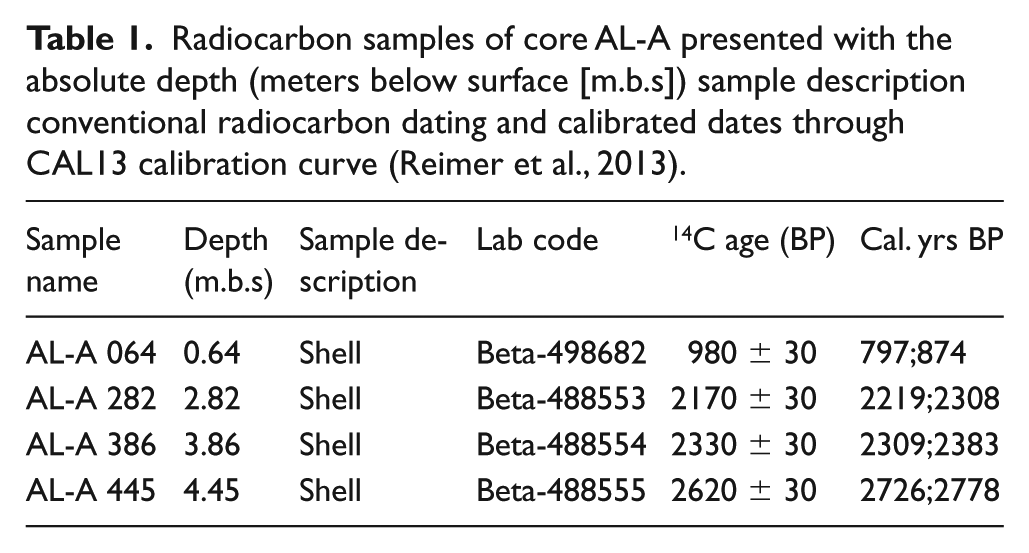
Age-depth model for core AL-A in cal. yrs BP. Chronological framework sets at around 3100 cal. yrs BP and the calibration is based on the IntCal13 calibration curve (Reimer et al., 2013) using the Bacon v2.3.3 software (Blaauw and Christen, 2011).
Results
Core description/accumulation rates
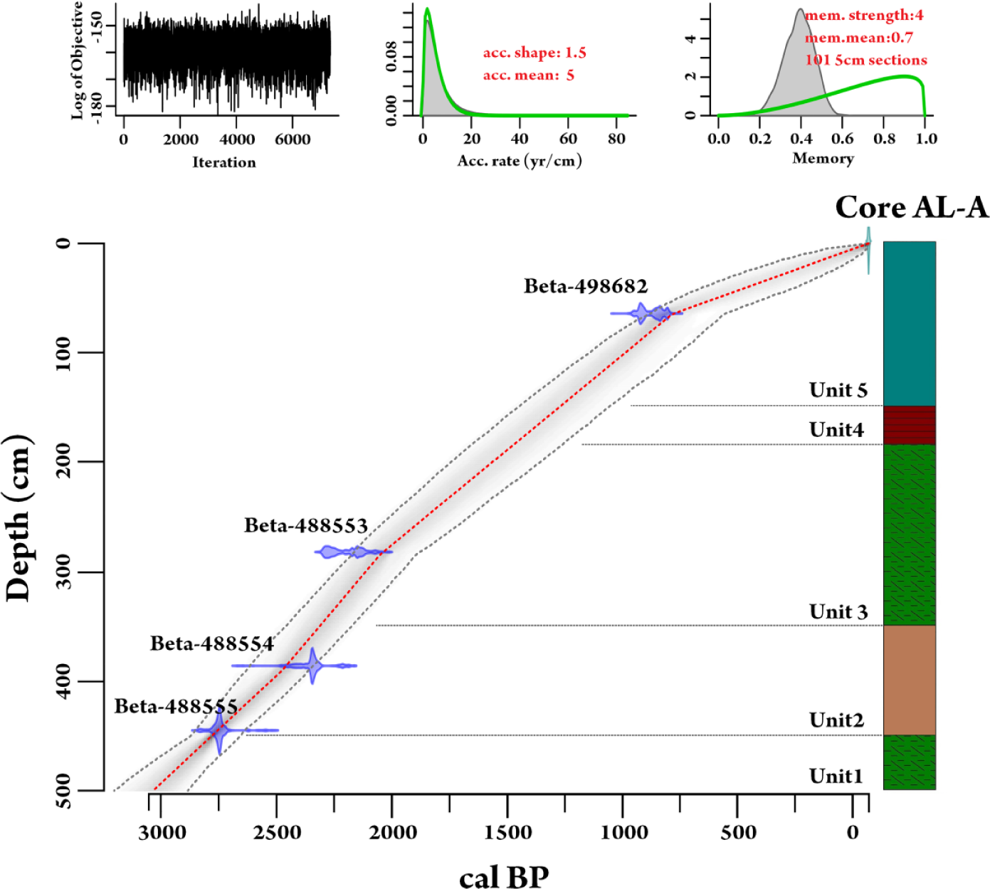
Grain size analysis, moment measures, magnetic susceptibility (MS) measurements, microfossil presence, RGB color profile plot, and mineralogical analysis provided an overview for the different lithological units in cores AL-A, AL-B, and AL-C. For the central core AL-A (5 m), the lithological units are described below.
Unit 1 (5.0–4.5 m) consists of very poorly to poorly sorted grayish brown silty clay (Figure 3). The grain size distribution is coarse, skewed to symmetrical and leptokurtic to platykurtic (Figure 3). The mean TOC content is 2.32% and the carbonate content (CaCO3) ranges from 11.8% to 25.2% with a mean value of 18.5% (Figure 3). The unit is characterized by abundant foraminiferal assemblages and the higher calcite content measured in the core (Table 1 and Figure 4). Clay minerals and quartz also present high values with 10% and 42%, respectively, and quartz values range from 20% to 42% (Table 2).
Log profile of core AL-A, presenting the lithological units, grain size distribution, statistical parameters, total organic carbon, carbonate content, magnetic susceptibility measurements with step of 0.5 cm and RGB profile plot.
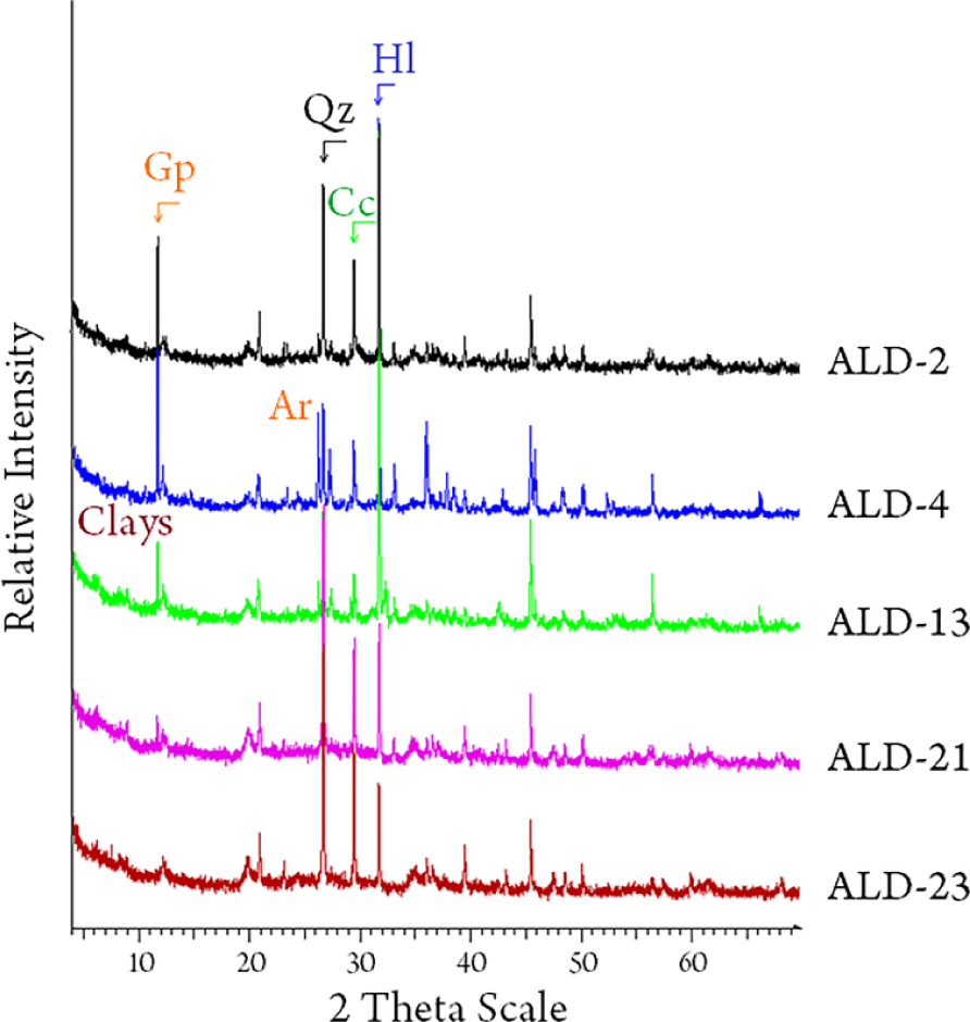
Representative x-ray diffraction samples from each lithological unit, showing the presence of the main minerals recognized. Qz: Quartz, Gp: Gypsum, Hl: Halite, Cc: Calcite, Ar: Aragonite.
Percentages of each mineral recognized from the x-ray diffraction analysis conducted on 29 samples from core AL-A.
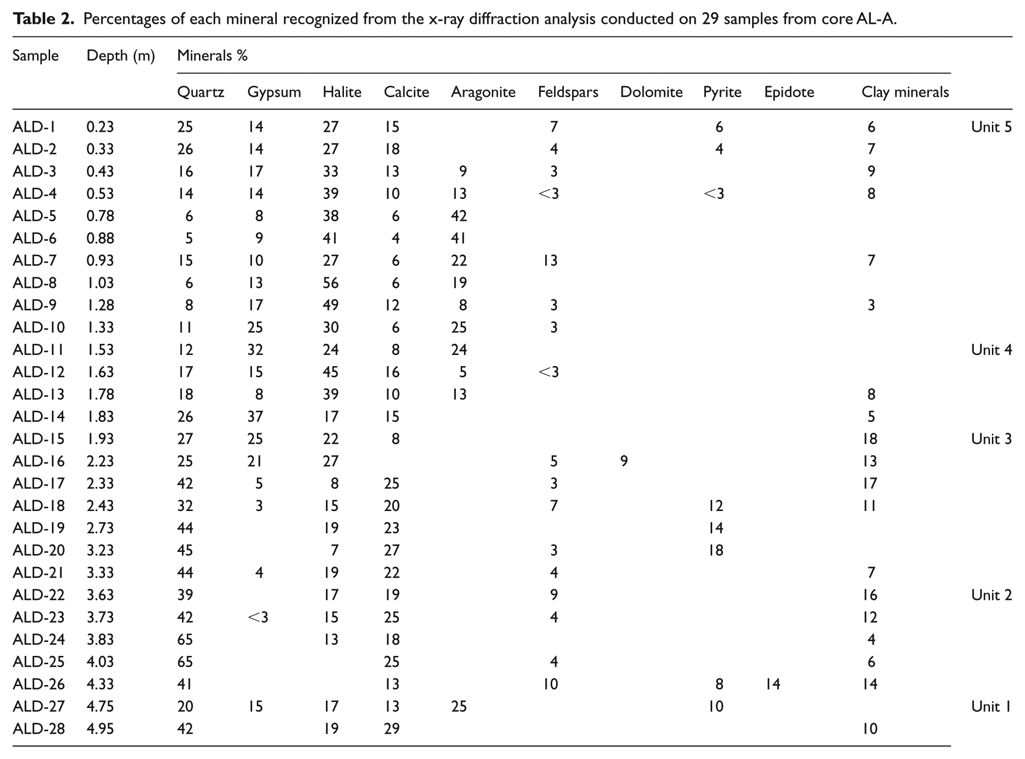
Unit 2 (4.5–3.5 m) consists of very to poorly sorted grayish brown sandy silt (Figure 3). The grain size distribution appears as coarse, skewed to fine skewed and mesokurtic to very platykurtic distribution (Figure 3). Unit 2 is characterized by the highest values in MS measurements (Figure 3). Calcite values range from 13% to 25%, whereas quartz presents the highest values measured in the core with a maximum value of 65% (Table 2). Halite is present, but its content is the lowest measured in the core with 15% value (Table 2 and Figure 4). TOC and carbonate content (CaCO3) content also have their minimum in this unit of core AL-A (Figure 3). Microfaunal assemblages were completely absent in unit 2.
Unit 3 (3.5–1.85 m) consists of very poorly to poorly sorted medium silt to fine silt (Figure 3). The studied samples show a very coarse skewed to symmetrical and leptokurtic to platykurtic distribution (Figure 3). Clay minerals range from 4% to 16% and calcite from 8% to 27% (Table 2). Pyrite is present with a mean value of 14.6% (Table 2). The mineralogy and sedimentary characteristics in this unit are similar to those of unit 1, exhibiting once more abundant foraminiferal assemblages.
Unit 4 (1.85–1.50 m) consists of very poorly to poorly sorted medium silt to fine silt. Between 1.70 and 1.81 m, laminations (mm scale) of organic rich sediments alternating with evaporite deposits were recognized. From 1.56 to 1.67 m, a soft sediment plastic deformation was recognized, probably triggered by a seismic event in the study area. Mean values of TOC and carbonate content (CaCO3) are 2.24% and 23.9%, respectively (Figure 3) with higher carbonate content (CaCO3) in the evaporite layers. Halite and gypsum values range from 17% to 45% and from 8% to 37%, respectively (Table 2 and Figure 4), whereas high aragonite values (24%) were measured at depths 1.75–1.80 m (Table 2 and Figure 4).
Unit 5 (1.5–0.0 m) consists of very poorly sorted to poorly sorted mud to sandy mud (Figure 3). High concentration of halite and gypsum alternate regularly with evaporite and organic layers. Foraminifera are completely absent in unit 5, most likely due to the extreme salinity as indicated by the halite content, especially at 1.00–1.05 m (Figure 4). Gypsum content is also high with values from 8% to 25% (Table 2 and Figure 4). At 0.80 and 1.20 m, beachrock fragments are observed.
The highest accumulation rates of the sequence are attributed to unit 3 (1600–2300 cal. BP) and unit 2 (2300–2800 cal. BP) with 0.24 cm/yr and 0.20 cm/yr, respectively. For unit 1 (2800–3100 cal. BP), the accumulation rate was 0.14 cm/yr, and for unit 4 (1400–1600 cal. BP) and unit 5 (1400 cal. BP to present), 0.16 cm/yr and 0.10 cm/yr, respectively. The mean sedimentation rate for AL-A core is around 0.15 cm/yr.
Cores AL-B and AL-C (Figure 5) show no significant difference from unit 5 of core AL-A. However, the lower parts of both cores are characterized by very stiff sediment indicating that the salt pond margins must show high seasonal variations due to evaporation and precipitation/freshwater input.
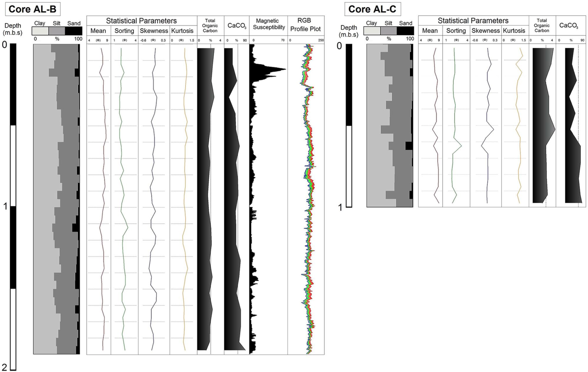
Log profiles of cores AL-B and AL-C, presenting lithological Units, grain size distribution, statistical parameters, total organic carbon, carbonate content (CaCO3), magnetic susceptibility measurements with step of 0.5 cm and RGB profile plot.
XRF core scanning
Principal component analysis has been applied to the XRF results for core AL-A, and the first two principal components that explain 75.71% of the total variance have been extracted (Figure 6a–c). Component 1 explains the 66.43% of the total variance of the data (Figure 6b and c) and is positively associated with the terrigenic/siliciclastic elements such as Al, Si, K, Ti, Mn, Fe, Zn, Rb, and Zr and negatively associated with the mostly evaporitic elements such as S, Br, Sr, and Ca. Component 2 which explains 9.28% of the variance (Figure 6b and c) is positively associated with Sr, Br, and S (Figure 6). Elements Pb and Ca do not seem to be strongly associated with neither two components (Figure 6). The two extracted components have a clear sign between terrestrial (component 1) and evaporitic (component 2) origin.
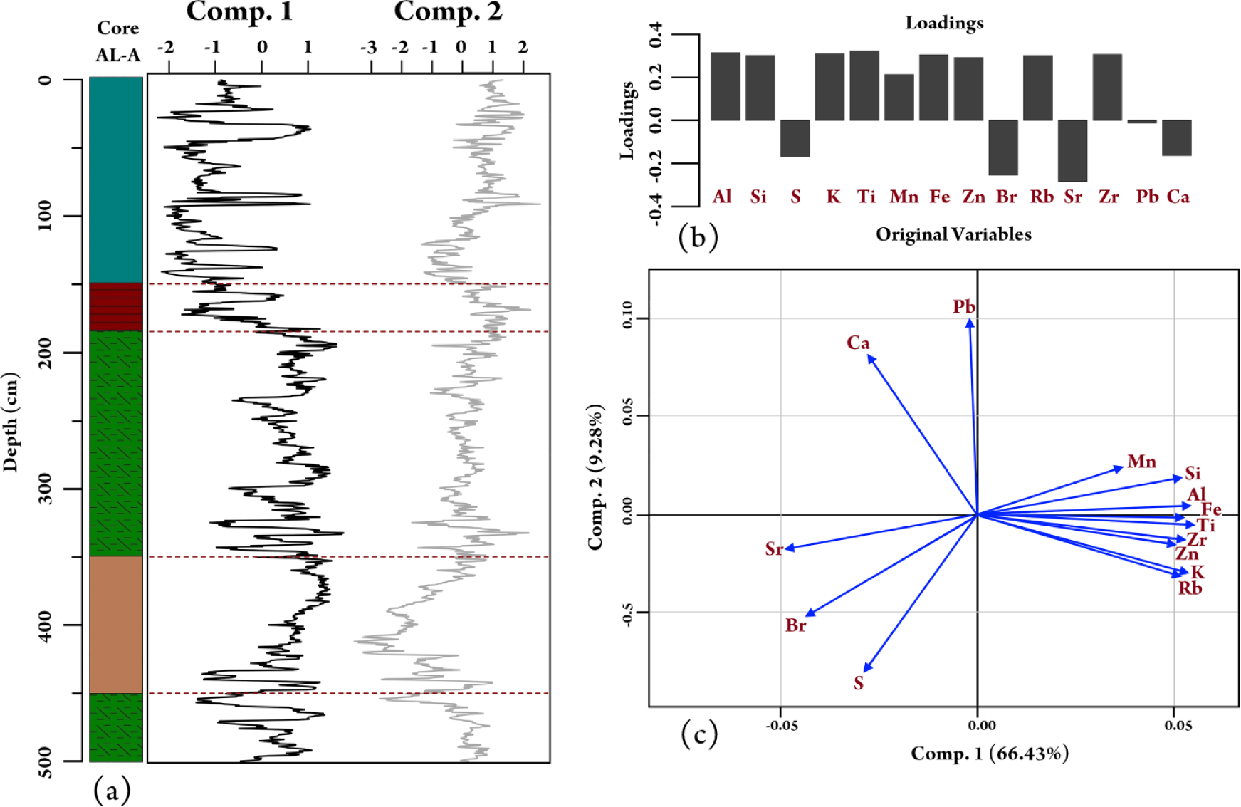
(a) Downcore variation of the loading scores of two extracted factors (components) against depth. (b) and (c) Plot of principal component analysis of x-ray fluorescence data from core AL-A. Component 1 explains the 66.43% of the variance and component 2 the 9.28% of the data.
Plotting the scores of PC1 and PC2 against depth shows a clear dominance of PC1 in unit 4 and a dominance of PC2 in units 1 and 2 (Figure 6a). The interaction between marine and terrestrial environment seems to be balanced in units 5 and 3. In unit 1, PC1 shows higher values in the organic-rich layers, whereas the evaporite-rich layers are characterized with higher PC2 values due to the presence of gypsum, halite, and high sulfur content (Figure 6a).
Micropaleontology
A total of 26 benthic foraminifera species has been identified in core AL-A and two barren intervals are recognized in depths 3.6–4.2 m and 0–1.97 m (Figure 8). In cores AL-B and AL-C, all samples were barren, possibly due to high salinity levels along the entire core. The cluster analysis performed within core AL-A discriminates two main groups (Figure 7). Group A consists of samples from the upper part of the core (2.3–3 m) and group B is mostly associated with samples found in the lower depths of the core (3–3.5 m, 4.3–5 m) but also with samples at depths 1.8–2.3 m.
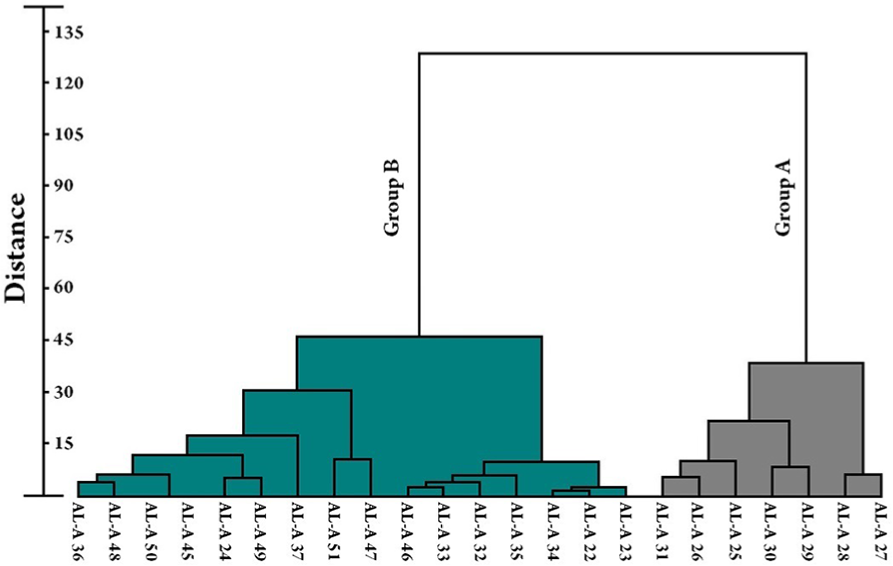
Dendrogram classifications of core AL-A samples, produced by Ward’s method (Euclidean distances as a similarity index).
Group A is characterized by the higher values of the Shannon–Wiener diversity index (Figure 8), used as a heterogeneity evaluation for core AL-A, which is determined by the distribution of the individuals in the different species (Magurran, 1988). The Shannon–Wiener index has been measured only for samples that were not barren, and for which the foraminiferal assemblages were statistically significant, by using Past.exe 1.23 software package (Hammer et al., 2001). The dominant species for group A is Ammonia tepida combined with the miliolid group (Figure 8). Also, from 2.5 to 3 m, the epiphytic foraminifera Peneroplis spp. and Lobatula lobatula were identified (Figure 8), whereas in upper parts of group A (2.3–2.5 m), the higher values of the benthic foraminifera Elphidium spp. and Haynesina germanica were calculated (Figure 8).
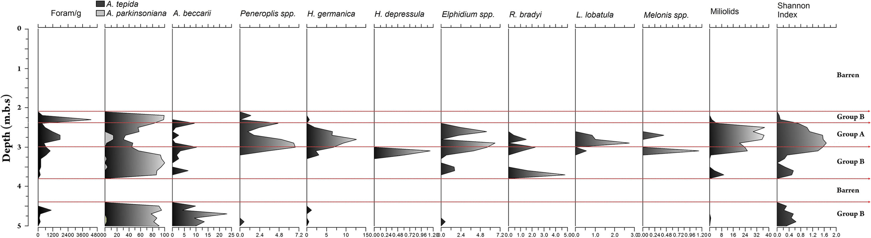
Downcore variation of foram/g, Shannon index, and representative benthic foraminifera species percentages recognized in core AL-A. Barren units and different groups extracted from the statistical analysis are presented at the end of the graph.
Group B is characterized by the dominance of the benthic foraminifera Ammonia tepida and the absence of miliolid (Figure 8). Specifically, at the lower parts of core AL-A (4.3–5 m), the dominance of the typical brackish benthic foraminifera Ammonia tepida is combined with the presence of the Ammonia beccarii (Figure 8). At depths 3–3.5 m, the dominance of Ammonia tepida is still clear, with the sporadic presence of other benthic foraminifera like Rosalina bradyi, Elphidium spp., Haynesina depressula, and Ammonia beccarii (Figure 8). Group B is also characterized by the lower Shannon–Wiener index values (Figure 8), since most of the foraminiferal assemblages are dominated by the presence of Ammonia tepida and the absence of other species. In depths 1.8–2.3 m, the appearance of the ostracod Cyprideis torosa should be noted, with very high values relative to those of Ammonia tepida.
Discussion
For the last 3100 years, Aliki salt pond seems to have gone through four different evolutionary stages, as indicated from the study of core AL-A and by compiling all the sedimentological, geochemical, and micropaleontological data. During that period, the dense human activity in the coastal areas of the Mediterranean region, as well as the constant modification of the environment, makes the identification of paleoclimatic signals difficult (Magny and Nebout, 2013; Pascucci et al., 2018; Roberts et al., 2001, 2011; Zanchetta et al., 2012).
From around 3100 to 2800 cal. BP, the study area can be characterized as a typical microtidal lagoonal environment, as indicated by the dominant presence of Ammonia tepida (Figure 9), a typical taxon that withstands salinity and temperature fluctuations and that flourishes in lagoonal and other near-shore environments (Almogi-Labin et al., 1992; Coccioni, 2000; Frontalini et al., 2009; Jorissen, 1988; Koukousioura et al., 2012; Melis and Violanti, 2006). Also, the co-existence of Ammonia tepida with Ammonia beccarrii indicates brackish conditions (Debenay and Guillou, 2002). Human occupancy in the study area seems to be established at around the end of Mycenaean (900–700/750 BC) to Archaic period (750/700–479 BC), as Thucydides mentions the seaport of Siphai in the History of the Peloponnesian War (4.76). Stable climatic conditions in the Mediterranean region during that time can be imprinted in the Rb/Sr ratio (Figure 9) and may have been drivers in rapid urbanization of the area. The Pb content, which, in ancient times, was produced by silver smelting (Åberg et al., 2001; Hong et al., 1994), shows increase at this period (Figure 9) and can be correlated with the human activity in the study area. Similar to our findings, Pb in soft sediments has been used as a proxy for anthropogenic activity in similar coastal environments by Le Roux et al. (2005) for the harbor in Marseilles and by Hadler et al. (2013) for the Lechaion harbor.
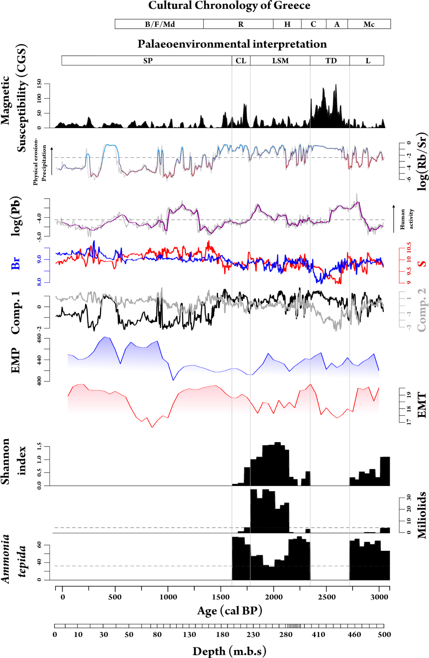
Multi-proxy diagram of the geochemical proxies log(Rb/Sr), log(Pb), Br and S, Factor 1 and 2 with the mean annual Eastern Mediterranean Precipitation (EMP) and Temperature (EMT) (Kaniewski et al., 2013) and Shannon index, miliolids, Ammonia tepida. The cultural chronology of Greece is based on Bintliff (2012), Manning (2010), Demoule and Perlés (1993), and Perlés (2001). The gray lines present the different evolutionary stages of Aliki salt pond for the last 3100 yrs BP. Mc: Mycenaean, A: Archaic, C: Classical, H: Hellenistic, R: Roman, B/F/Md: Byzantine/Frankish/Medieval, L: lagoon, TD: terrestrial deposit, LSM: lagoon/shallow marine, CL: closed lagoon, SP: salt pond.
The highest MS values at around 2700 to 2300 cal. BP (Figure 9) suggest a different sediment source (Mullins, 1977). The increase of MS and the clear decrease of elements like Br and S (Figure 9), which have marine origin, indicate a fluvial terrestrial deposit at this point. Also, the high presence of quartz (Table 2) is clearly correlated with the coarser sediment sequence recognized at this point. Although it can be easily identified by those means, the presence of such deposit is to be explained. Excessive precipitation as indicated by the Rb/Sr ratio (Figure 9) as well as seismic and even human activity would be likely to produce this sediment sequence. What is really important to mention is that around the end of the Classical Period (479–323 BC), Aristotle, in his book History of Animals (2.8.34), mentions the lake of ancient Siphai (ancient Aliki) is well known for its fish around the region: ‘In like manner the grey mullet-as, for instance, the mullet found in the lake at Siphai-have only two fins; and the same is the case with the fish called Ribbon-fish’. Although the exact period of time and the fact that Aristotle is actually speaking about Aliki salt pond cannot be really certified, ancient texts like this can provide really useful information about past evolutionary stages of such a coastal system.
From around 2300 to 1600 cal. BP, the dominance of Ammonia tepida and the miliolid group (Figure 9) indicate a more open lagoonal environment with constant freshwater inflow to the study area. The miliolid group that mostly occupies the infralittoral and upper circalittoral zones (Moulfi-El-Houari et al., 1999; Sgarella and Moncharmont-Zei, 1993) presents variations with the highest values at around 2000 cal. BP. The concomitant presence of Ammonia tepida with Elphidium spp. can be attributed to salinity fluctuations in the study area (Melis and Violanti, 2006; Pavlopoulos et al., 2007, 2010; Ruiz et al., 2006; Triantaphyllou et al., 2010, 2003). The Rb/Sr ratio, which is associated with the chemical weathering (Jin et al., 2001; Unkel et al., 2010), precipitation, and physical erosion in the study area (Unkel et al., 2014), coincides with the mean Eastern Mediterranean Precipitation (EMP) and temperature (EMT) (Kaniewski et al., 2013) (Figure 9) as well as with the relative cold period that followed the Roman Warm time, indicating a more wet/cold climate. The wet climatic conditions that occurred during the Classical and Hellenistic period in different areas in Greece have already been reviewed by Weiberg et al. (2016). Such abrupt climatic changes that have been recorded in the eastern Mediterranean region during that period have been one of the major drivers leading to human migrations. The Pb content presents increasing values during the start of the Roman Period (31
At around 1600 cal. BP, the decrease of the miliolid group and the dominance of Ammonia tepida combined with the presence of the ostracod Cyprideis torosa (Figure 9) provide a clear signal of the closing of the lagoon with salinity fluctuations (Melis and Violanti, 2006; Pavlopoulos et al., 2007, 2010; Ruiz et al., 2006; Triantaphyllou et al., 2003). Although the micropaleontological analysis for core AL-A was only conducted for benthic foraminifera species, the dominance of the ostracod Cyprideis torosa at this point had to be mentioned, since it provides clear evidence of a more restricted environment compared with the rest of the sequence. The beachrock formations that form the barrier of the lagoon (Figure 1d), as discussed above, show a clear uplift due to a tectonic event that seems to have occurred in this time and have separated the lagoon from the marine environment.
After the closing of the lagoon due to the beachrock uplift, the study area seems to take its final form at around 1400 cal. BP (Figure 9). Evaporation and precipitation fluctuations provide the laminated sequences of evaporitic- and organic-rich layers. Gypsum and aragonite high values (Table 1) provide a clear sign of evaporitic depositional environment, whereas aragonite precipitation in Holocene nearshore hypersaline environments is really common in coastal aquatic systems that receive seawater input (Warren, 1990). The increase of Rb/Sr ratio at the organic-rich layers and the mean EMP also provide some paleoenvironmental information. The input of Rb into the sediment represents the clay-rich organic parts, since Rb substitutes K in K-feldspars (Kylander et al., 2011), whereas Sr is linked to the rich authigenic carbonate layers (calcite, evaporites) (Jin et al., 2006). Thus, the Rb/Sr ratio seems to work as an indicator for precipitation/physical erosion in the catchment of the salt pond. The distinct decrease of the Rb/Sr ratio during Byzantine/Frankish/Medieval period (AD 641–1460) (Figure 9) is coinciding with the warm climate prevailing during Medieval Climate Anomaly (AD 950–1250), which has also been documented in the Aegean region (Gogou et al., 2016). The S content is also presented by the highest values during this unit due to high evaporites concentration into the salt pond (Burn and Palmer, 2014). A drastic increase in the Rb/Sr ratio is also recorded around 700–250 cal. BP and may be related to regional climate abnormalities during the ‘Little Ice Age’ period.
Conclusion
Aliki salt pond represents the only existing coastal wetland in the northern part of the Gulf of Corinth. The combined sedimentological, geochemical, and micropaleontological data indicate that the depositional environment of Aliki salt pond is highly influenced by different sedimentological processes, tectonic activity, and climatic conditions. Although the Gulf of Corinth is prone to high hydrodynamic events (tsunamis), no such phenomena were recognized in this study, most likely due to the natural barrier (Domvraina Gulf) of the area. Through a multi-proxy analysis of the three cores retrieved, four different evolutionary stages were recognized for the last 3100 cal. BP. From around 3100 to 1600 cal. BP, a transition from a closed to more open lagoonal environment was recognized. A fluvial terrestrial deposit at around 2500 cal. BP seems to interrupt the sediment sequence and may be attributed to wet climatic conditions during that time. The rapid transition from an open lagoonal environment to a closed/chocked one at around 1600 to 1400 cal. yrs BP can be correlated with a tectonic uplift of the beachrock barrier of Aliki salt pond and marks the establishment of the salt pond environment.
Stable climatic conditions recorded around the end of the Mycenaean period (900–700/750 BC) seem to have played an important role in the urbanization of ancient Siphai. Ancient remnants and historical reports highlight the beginning of human occupancy of the area in different periods and are substantially related to more balanced climatic conditions. A relative cold event recorded around the Hellenistic period seems to also correspond to decreasing human activity. After 1550 cal. BP, more large-scale climatic events like the ‘Medieval Warm Period’ and the ‘Little Ice Age’ seem to drastically affect the sedimentation processes and landform development in the study area, thus forming a more unsustainable environment for urban growth.
Footnotes
Funding
The author(s) disclosed receipt of the following financial support for the research, authorship, and/or publication of this article: This research is co-financed by Greece and the European Union (European Social Fund (ESF)) through the Operational Program ‘Human Resources Development, Education and Lifelong Learning’ in the context of the project ‘Strengthening Human Resources Research Potential via Doctorate Research’ (MIS-5000432), implemented by the State Scholarships Foundation (ΙΚΥ). Laboratory analysis and radiocarbon dating that were conducted for this study were partially funded under the project entitled ‘Holocene Sedimentological Processes and Palaeoenvironmental Changes in Coastal Lagoon Systems of western Greece’ (ΦΚ 5661) and supported by the University of Patras Research Committee via ‘K. Karatheodori’.