
Abstract
A multiproxy study from Sweeton Pond, Ozark County, Missouri, USA, provides a high-resolution 1900-year-long history of vegetation and fire in the southern Missouri Ozarks, where the modern vegetation is oak-hickory (Quercus-Carya) forest. Pollen and charcoal data are compared with dendroecological data to assess how climate and fire shaped local vegetation history. Land use, particularly by the Osage tribe of Native Americans, is assessed from historical and archaeological records. Three cultural periods are superimposed on the paleoenvironmental history: (1) The Pre-Osage period, ending ~1500 CE, was characterized by open oak-hickory forest and frequent low-severity fires, suggesting interannual climate variability as a driver of vegetation and fire occurrence. At ~1360 CE, mesic tree species began to expand, while fire frequency remained low. (2) The Osage period (~1500–1820 CE) was characterized by the continued expansion of mesic, fire-sensitive species, especially elm (Ulmus), in conjunction with cool, effectively wet conditions in the southern Missouri Ozarks. Despite climate conditions less favorable for fire, Osage expansion in the region was accompanied by increased fire and fire-dependent shortleaf pine (Pinus echinata). The expansion of both fire-sensitive and fire-dependent taxa coincident with Osage occupation suggests that anthropogenic fire and land use was local in nature and increased landscape heterogeneity prior to Euro-American settlement. (3) The Euro-American period (since ~1820 CE) was characterized by increased disturbance pollen types (e.g. Ambrosia-type) at the expense of shortleaf pine pollen, resulting from increased settlement size and extensive agricultural and logging activities. During this period, forest clearance led to fuel fragmentation, reducing fire activity; after 1920 CE, fire was actively suppressed.
Keywords
Introduction
The role of fire in shaping the eastern woodlands of North America has long been debated (Abrams, 1992; Day, 1953; Patterson and Sassaman, 1988; Russell, 1983). However, along the western prairie-forest border of this region, ecologists generally agree that fire has had a major influence on forest distribution and composition (e.g. Batek et al., 1999; Grimm, 1984; Williams et al., 2009; Wuenscher and Valiunas, 1967). Sedimentary pollen and charcoal records have been used to elucidate the relationship between vegetation and fire along the prairie-forest border during the Holocene in Wisconsin and Minnesota (Camill et al., 2003; Clark, 1990; Grimm, 1984; Umbanhowar et al., 2006; Williams et al., 2009), and farther east into northern conifer and hardwood forests (Lynch et al., 2006, 2011). In contrast, little is known about the role of fire in shaping the prairie-forest border south of Wisconsin and Minnesota, where prairie borders Quercus-Carya forest, except from historical and dendroecological records that span only the last 300 years (e.g. Batek et al., 1999; Cutter and Guyette, 1994; Guyette et al., 2002; Stambaugh and Guyette, 2006).
In this study, we provide a high-resolution vegetation and fire history from Quercus-Carya forest in the southern Missouri Ozarks for the last 1900 years, based on pollen and charcoal data from Sweeton Pond. The high-resolution of this record is facilitated by a 7.92 m core with a deposition time averaging ~2.4 yr·cm−1. We also address the debate regarding the magnitude and spatial extent of Native American landscape alteration (e.g. Abrams and Nowacki, 2008; Gajewski et al., 2017; Munoz et al., 2014; Vale, 2002), by assessing the influence of Native American and Euro-American land use on the local vegetation and fire history. To assess how land use has altered local vegetation and fire history, we integrate the results of pollen, charcoal, and geochemical analyses from Sweeton Pond with published historical accounts and archaeological research (Figure 1a; Bailey, 1973; McMillan, 2014b; Ponziglione, 1882; Schoolcraft, 1821). Dates are presented as Common Era (CE), calendar years before present (BP), or calibrated years before present (cal. yr BP), where ‘present’ is 1950 CE.
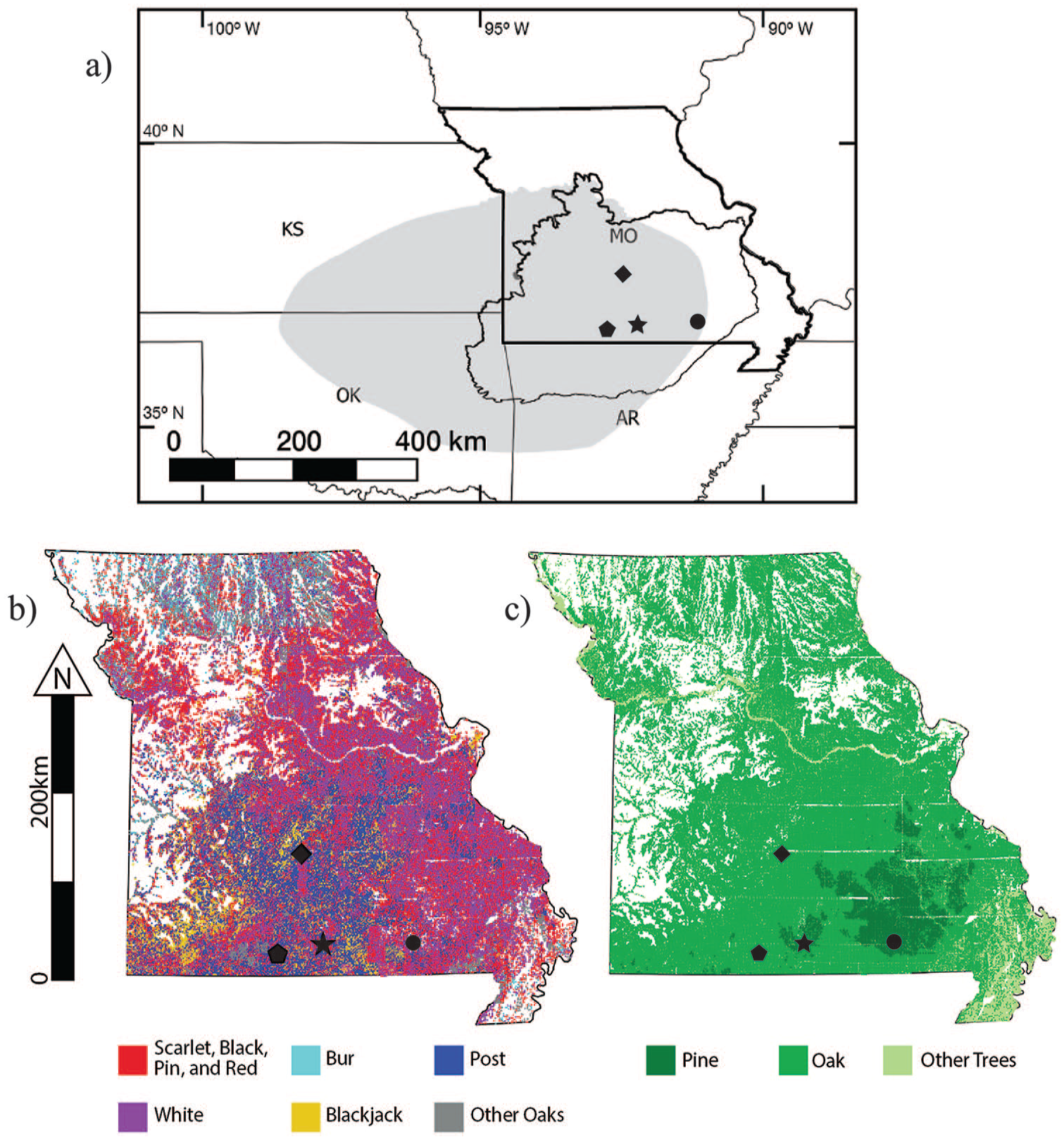
(a) Map of Sweeton Pond (star), Cupola Pond (circle, Jones et al., 2017), and dendroecological studies (diamond, Cutter and Guyette, 1994; pentagon, Guyette and McGinnes, 1982) within the Ozark Highlands (black border not associated with state boundaries), and the extent of Osage occupation (gray, Bailey, 2001). (b, c) Map of oak species recorded in Public Land Surveys from 1815–1850 CE (Missouri Spatial Data Information Service, http://msdis.missouri.edu). (b) Scarlet (Quercus coccinea), black (Q. velutina), pin (Q. palustris), and red oak (Q. rubra) were grouped (red) because of likely misidentification by surveyors. Bur (Q. macrocarpa, light blue), post (Q. stellata, dark blue), white (Q. alba, purple), blackjack (Q. marilandica, yellow), and other oaks (gray) are also plotted. (c) Oak (green), pine (dark green), and other trees (light green) are plotted.
Study area
The Ozarks are a dissected highland biogeographic region located primarily in southern Missouri and northern Arkansas (35–39°N lat.), bordered by the Missouri River to the north and the Arkansas Valley to the south (Figure 1a; King, 1973). The Ozarks are the westernmost extension of the Eastern Deciduous Forest, with prairie to the west. Today, the Missouri Ozarks are dominated by Quercus-Carya forest (Braun, 1950; Dyer, 2006; Hanberry et al., 2014b; King, 1973). Pinus echinata was abundant in southeastern Missouri, until it was heavily logged at the end of the 19th century (Figure 1c; Braun, 1950; Dyer, 2006; Holmes, 1968).
Archaeological investigations from the Ozarks suggest that human occupation of the region was transient throughout the Paleoindian (~10,950–9550 BP), Archaic (~9550–2500 BP), and Woodland (~2500–1050 BP) periods (Klippel et al., 1978; Ray et al., 1998; Wolverton, 2005; Wood and McMillan, 1976). Although the Mississippi and Ohio River Valleys were heavily populated by the agricultural Mississippian societies after 900 CE, 1050 cal. yr BP (peaking by ~1120 CE); the Ozarks were not heavily occupied until major Euro-American settlement in the 19th century CE (Bird et al., 2017; Holmes, 1968; Pauketat, 2003). Archaeological and historical evidence suggests that the Osage tribe of Native Americans arrived in the region between the end of the 15th and the beginning of the 16th centuries CE (Bailey, 2001; McMillan, 2014b) (Figure 1a). The Osage subsisted on mixed hunter-gatherer-horticulturist strategies, living primarily in permanent villages on the prairie-forest border (Bailey, 1973). Osage hunting parties were short, seasonal ventures into the prairie for bison and into the Ozark woodlands for elk and deer, often utilizing fire in the process (Ponziglione, 1882; Schoolcraft, 1821, 1853).
Sweeton Pond is a small, deep sinkhole pond (36.7914°N, 92.2231°W, 304 m elev., 0.5 ha, 14.6 m maximum depth) in northern Ozark County, Missouri (Figure 1). The pond lies in a woodlot dominated by Quercus alba, Carya, Ulmus, Nyssa sylvatica, and Juglans nigra. Cephalanthus occidentalis grows in the littoral zone and Salix nigra is present along the shore. The pond is located near the extreme northwestern limit of P. echinata, which has a modern range in the warm, humid southeastern United States, where January temperatures range from 0°C to 12°C and July temperatures range from 25°C to 30°C, and annual precipitation ranges from 102 to 152 cm·yr−1 (Lawson, 1990; Webb et al., 1993; Williams et al., 2006). The species is shade intolerant and highly dependent on fire for regeneration (Guyette et al., 2007; Lawson, 1990). Locally, Pinus was concentrated in the valleys of the North Fork River to the east of Sweeton Pond and Bryant Creek to the west until ~1870 CE (Figure 1c; Holmes, 1968).
Materials and methods
Public Land Surveys (PLS) vegetation reconstruction
The original PLS from Missouri provide a record of tree distributions from 1815 to 1850 CE, before intensive forest clearance by Euro-American settlers. The surveyors partitioned the land into townships of ~36 square miles (93.2 km2), divided into 36 sections of ~1 square mile (2.6 km2). Surveyors marked two to four ‘bearing trees’ at section corners and two bearing trees at quarter-section corners midway between section corners. They recorded bearing trees in field notes by common name, diameter, and distance and bearing from the corner. The bearing-tree data for Missouri are available from the Missouri Spatial Data Information Service (http://msdis.missouri.edu). For this study, the bearing-tree distributions of Pinus, common Quercus taxa, and other trees were mapped for the entire state of Missouri to reconstruct forest composition immediately prior to Euro-American settlement (Figure 1b and c).
Coring, lithology, and chronology
Two cores, SWP-A and SWP-C, were obtained ~1 m apart with a 5-cm-diameter Wright square-rod piston corer (Wright et al., 1984) in July, 1994 CE. Cores were imaged at the National Lacustrine Core Facility at the University of Minnesota using a Geotek Geoscan-III at a 10 pixel·mm−1 resolution. The two cores were stratigraphically aligned and cut into 1-cm sections to form a continuous 792-cm-long composite core.
Organic, carbonate, and non-carbonate inorganic content percent by mass values were determined by loss-on-ignition analysis (LOI; Heiri et al., 2001). Terrestrial plant remains and charcoal particles were collected for AMS radiocarbon dating during initial sub-sampling and charcoal counting. An age-depth model was developed from a series of 2 calendar ages and 10 uncalibrated AMS radiocarbon dates (Table 1) using Bacon 2.2 (Blaauw and Christen, 2011). Bacon calibrates the radiocarbon dates using Bayesian techniques that consider the stratigraphic ordering of the dates and the prior assumption that dates higher in the sequence must be younger. Consequently, the probability distribution functions of the calibrated ages can be narrower than dates calibrated individually with non-Bayesian techniques (Table 1), especially if the probability distribution functions of the non-Bayesian calibrated dates overlap, as they do from Sweeton Pond. Bacon produces weighted mean ages and 95% highest posterior density (HPD) intervals, essentially Bayesian confidence limits, for sample ages. The age model is based on the IntCal13 calibration curve (Reimer et al., 2013).
Calendar ages and AMS radiocarbon dates from Sweeton Pond, Missouri, US.

Calibrated with CALIB 7.10 using the IntCal13 calibration curve (Reimer et al., 2013; Stuiver et al., 2017). The input data for the Bacon age model are the raw radiocarbon dates, which Bacon calibrates using Bayesian techniques (see text).
Rise in Ambrosia pollen indicates local Euro-American settlement and land clearance (Holmes, 1968).
Dates for the core top and Ambrosia rise are calendar years before present (1950 CE).
Pollen and charcoal analyses
Samples for pollen analysis were prepared with standard procedures using a microsphere tracer and mounted in silicone oil (Faegri et al., 1989). Percentages for terrestrial taxa were calculated based on a sum of at least 300 terrestrial pollen and spores, while percentages for aquatic taxa were based on a denominator of total pollen and spores. Zonation of the pollen data was based on stratigraphically constrained incremental sum-of-squares cluster analysis (CONISS; Grimm, 1987; Grimm et al., 2011).
Samples for charcoal analysis (1 cm3) were treated with a 10% solution of tetrasodium diphosphate (Na4P2O7), and then gently washed through nested 250 and 180 µm sieves. Charcoal was identified and counted at 10–40× magnification (Whitlock and Larsen, 2001). CharAnalysis Version 1.1 (Higuera et al., 2009) and REDFIT spectral analysis (Schulz and Mudelsee, 2002) were used to interpret charcoal data. Sedimentation rates were calculated from a fourth-order polynomial fit to the weighted mean ages from the Bacon age-depth model. In CharAnalysis, charcoal concentration values (particles·cm−3) were divided by an interpolated temporal resolution of 2 yr·sample−1, the median sampling resolution of the entire record, to provide an interpolated charcoal accumulation rate (CHAR, particles·cm−2·yr−1). A 100-yr moving median was used to describe background charcoal (BCHAR). Fire episodes were defined as the positive residual values from interpolated CHAR above the BCHAR values at the 99th percentile. To separate fire-related (signal) from non-fire related variability (noise), charcoal-peak values had to surpass this percentile of a locally defined Gaussian distribution model (Higuera et al., 2009). CHAR data, calculated separately from CharAnalysis, but also using the weighted mean values from the Bacon age-depth model, then underwent spectral analysis using REDFIT, to test for frequently re-occurring fire return intervals (FRI: years between fires) (Brown et al., 2005; Gilman et al., 1963).
Results
Public Land Surveys (PLS) vegetation reconstruction
The bearing-tree maps show that southern and southeastern Missouri were heavily forested prior to intensive Euro-American settlement, whereas northern and western Missouri supported a mosaic of forest and prairie, with trees mainly along river valleys and grasslands generally in upland settings (Figure 1b and c). Quercus was common in forested upland areas, but not in the riparian forest along Missouri and Mississippi rivers. Pinus grew on the more rugged terrain of southeastern Missouri, west of the Mississippi floodplain. Significant disjunct populations of Pinus occurred along the North Fork River and Bryant Creek, which lie ~5 km east and west of Sweeton Pond, respectively (Figure 1c).
Individual maps for Quercus coccinea, Q. velutina, Q. palustris, and Q. rubra were grouped together (henceforth the red oak group) in Figure 1b because they showed considerable variability and misidentification by surveyors. Q. alba and the red oak group were common throughout Missouri. Q. macrocarpa occurred across the landscape in northern Missouri and in mainly riparian habitats throughout the rest of the state. However, the rectangular shape of the Q. macrocarpa distribution in northern Missouri and complete absence in extreme northeastern Missouri suggests that many surveyors misidentified it as Q. alba. Nevertheless, a geographic pattern does exist in the distribution of Quercus species favoring different growing environments. For example, Q. alba was particularly abundant in southcentral Missouri, including the area around Sweeton Pond, while Q. marilandica was most common in drier southwestern Missouri.
Chronology and lithology
Based on the Bacon age-depth model, the basal age of the core is ~1870 cal. yr BP (95% HPD interval: 2000–1750 cal. yr BP; Figure 2). Sediment was generally an organic-rich silty-clay with woody fragments and plant macrofossils throughout. Based on LOI, organic content varied from 2.8% to 41.6% of dry mass, carbonate 0.7–7.5%, and non-carbonate inorganic 57.0–96.3% (Figure 2). Deposition time changed gradually: from 3.1 yr·cm−1 at 792–773 cm depth (~1870–1820 cal. yr BP), to 2.6 yr·cm−1 at 773–234 cm (~1820–420 cal. yr BP), to 2.5 yr·cm−1 at 234–139 cm (~420–180 cal. yr BP), and to 1.6 yr·cm−1 at 139–0 cm (~180–44 cal. yr BP).
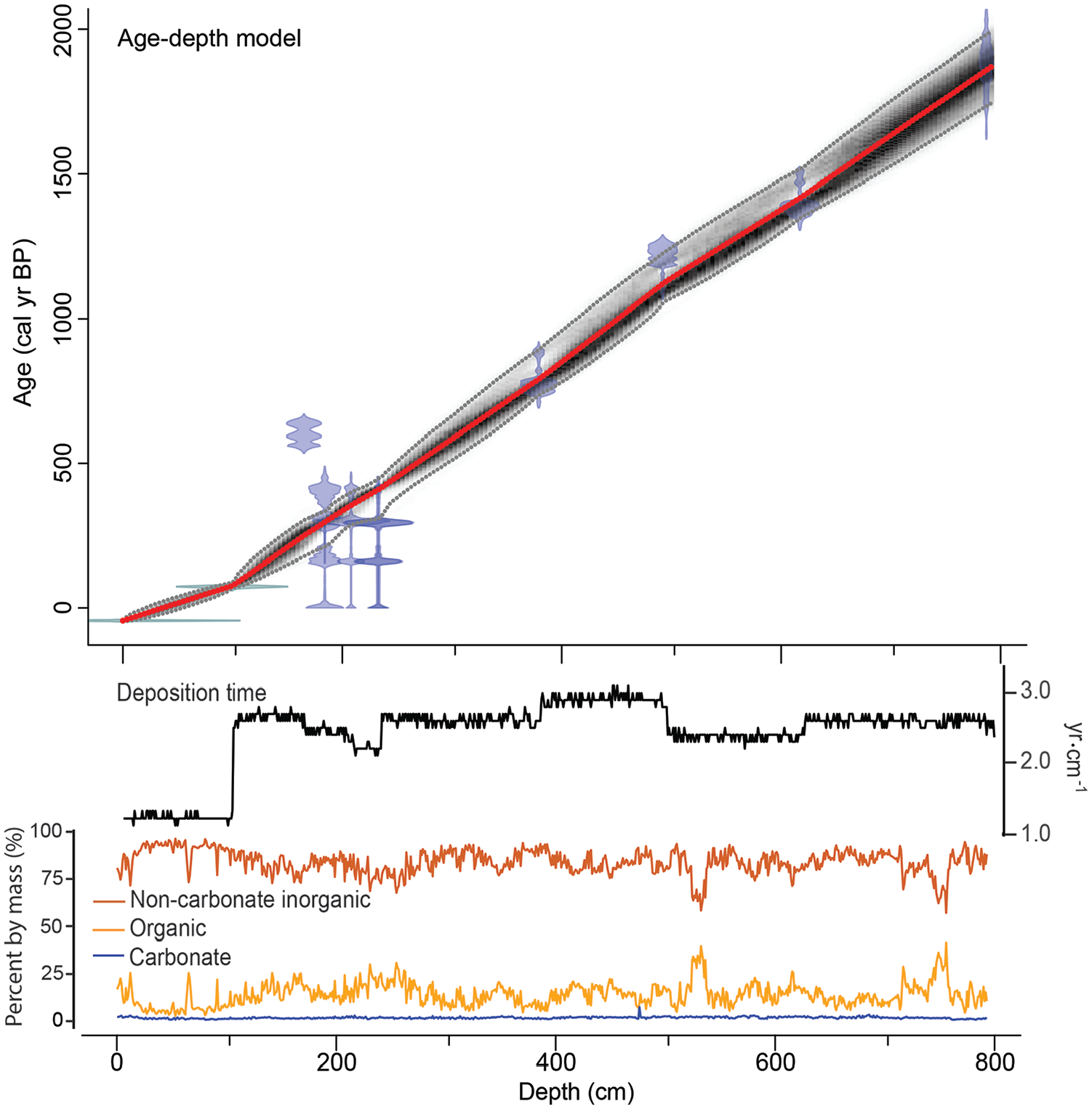
Age-depth model for Sweeton Pond using Bacon 2.2 (Blaauw and Christen, 2011). Bayesian priors were as follows: acc.shape = 1.5, acc.mean = 2.5, mem.strength = 4, mem.mean = 0.7, thick = 5) Blue areas represent the probability distributions of the calibrated dates, the dotted red line shows the weighted mean age for each depth, and gray shading and dotted light gray lines depict the most likely age-depth model and 95% highest posterior density intervals. The deposition time rate (yr·cm−1), percent composition of organic (light orange), carbonate (blue), non-carbonate inorganic (dark orange), and lithologic units are described in the text.
Pollen and charcoal analyses
Based on the CONISS cluster analysis, five stratigraphic zones (SWP-1 to SWP-5) were defined. The salient features are as follows (Figures 3 and 4).
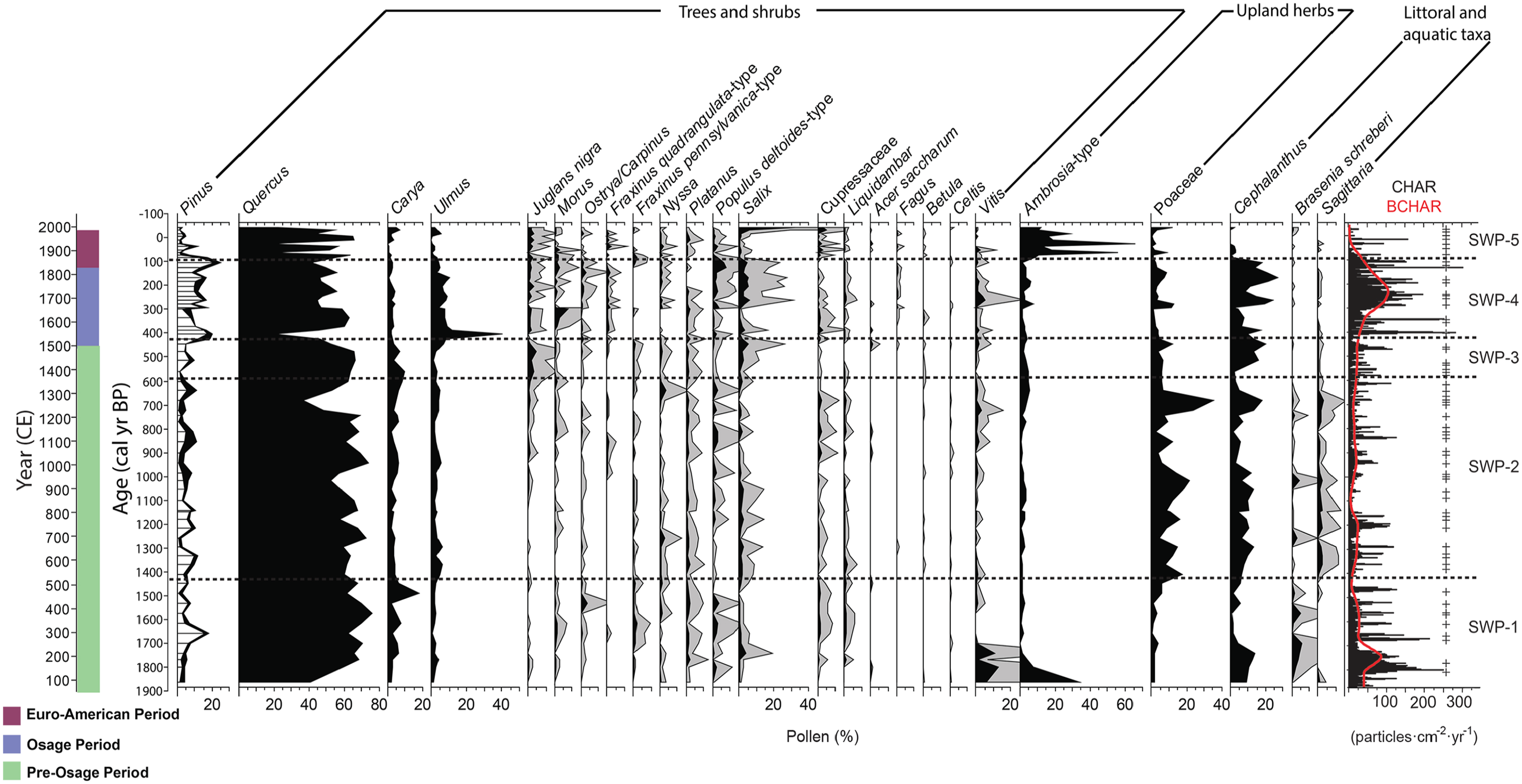
Pollen percentage diagram from Sweeton Pond showing dominant pollen taxa and charcoal data. Rarer taxa are provided with a 5× exaggeration (gray). Pollen zones were identified based on CONISS analysis (Grimm, 1987). Charcoal accumulation rates (CHAR, black line) and background CHAR (red line) describe variations in fire activity, and significant charcoal peaks (+) represent fire episodes. Sociocultural periods used to discuss the record are provided and explained in the text.
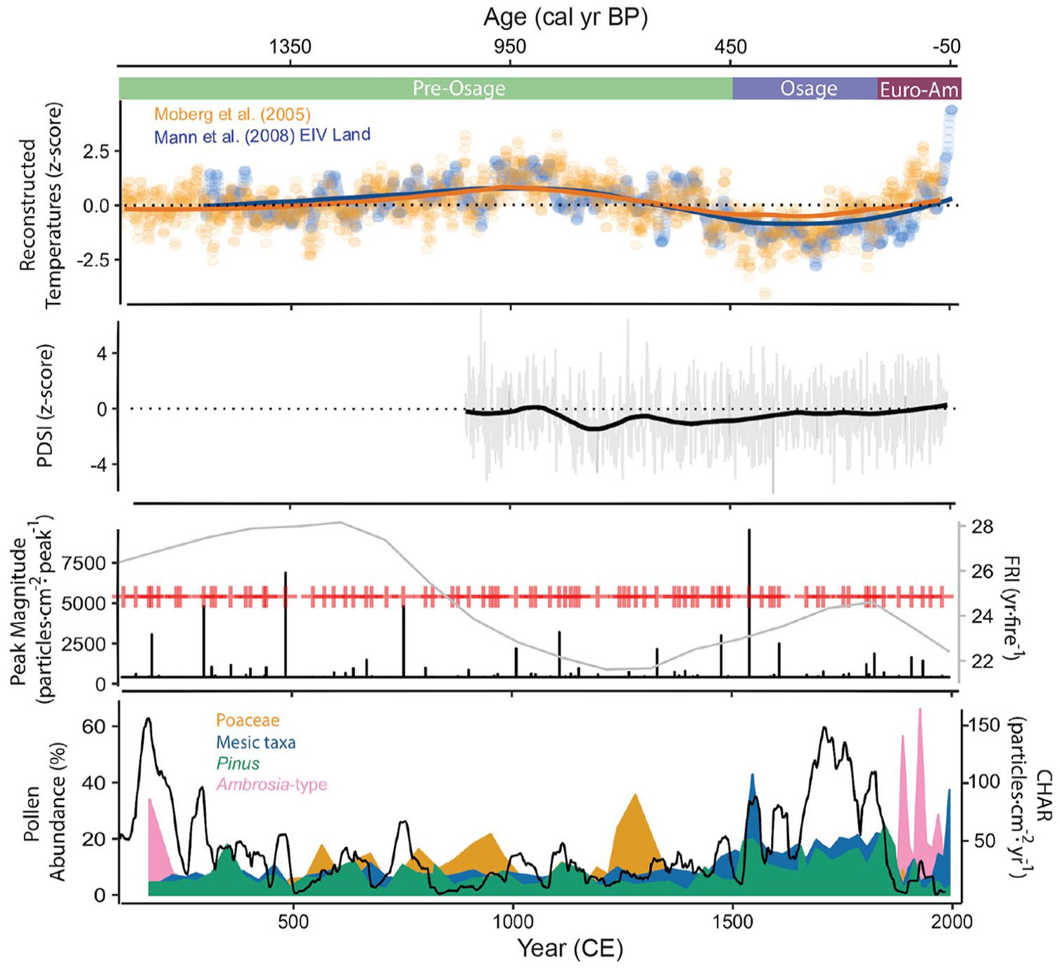
Temperature reconstructions from Moberg et al. (2005) (orange) and Mann et al. (2008) (blue, EIV land) are plotted by z-score. The annual (gray) and smoothed (black) PDSI for the Ozark region is provided, beginning 900 CE (ca. 1050 cal. yr BP) (Cook et al., 2010). Significant peaks are plotted (red+) with their magnitudes (black) and fire return intervals (gray). Percent pollen abundance of Poaceae (orange), mesic taxa (i.e. Ulmus, Fraxinus quadrangulata-type, Juglans nigra, Morus, Ostrya/Carpinus, and Populus deltoides-type combined; blue), Pinus (green), and Ambrosia-type (pink) are overlaid and plotted with charcoal accumulation rate (black).
REDFIT spectral analysis of the CHAR data shows that fire-episode frequencies varied throughout the record, surpassing a chi-square test with 90%, 95%, and 99% confidence intervals (CI; Figure 5). Significant FRIs (>95% CI) are 5–10 yr·fire−1. Highly significant FRIs (>99% CI) are 6–8 yr·fire−1. The only FRI to surpass the 99.87% false alarm CI is 7 yr·fire−1.
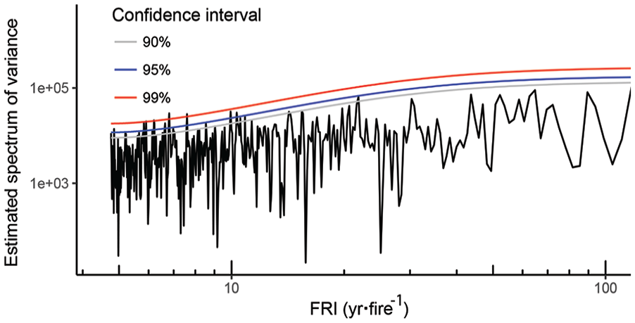
Results of REDFIT spectral analysis are plotted. CI is provided and a false alarm CI of 1-n−1 – where n is the number of data points – is used in the text to highlight frequencies with the least probability of being the result of red noise (Schulz and Mudelsee, 2002; Thomson, 1990). Here, the false alarm CI is 99.87% (n = 792).
Discussion
Northern Hemispheric temperature reconstructions show a warming trend from ~1350 to 600 BP, encompassing the Medieval Climate Anomaly (MCA; ~1000–700 BP). This period was followed by cooler temperatures from ~600 to 50 BP, during the ‘Little Ice Age’ (LIA; ~550–250 BP) (Figure 4; Mann et al., 2008; Moberg et al., 2005). Smoothed Palmer Drought Severity Index (PDSI) values decreased from ~890 to 760 BP, indicating increased summer aridity (Figure 4; Cook et al., 2010). After ~760 BP, smoothed PDSI increased to zero by ~1930 CE (20 BP), suggesting that although summer conditions remained dry, aridity decreased through present.
El Niño–Southern Oscillation (ENSO) was also likely a driver of climatic conditions throughout the Sweeton Pond record, especially given that ENSO frequency has been elevated since ~2000 BP (Moy et al., 2002). In the Ozarks, El Niño events can increase spring precipitation, which can lead to increased fuel biomass, while La Niña events are associated with warmer winters, earlier summers, and effectively drier conditions year-round, which increases fuel flammability (Henson et al., 2017; Newberry et al., 2016).
Synthesizing the paleoecological, historical, and archaeological records with independent climate data allows us to address how changes in climate and land use have altered vegetation and fire history in the Missouri Ozark ecosystem. Here, we delineate three socioecological periods: (1) Pre-Osage, ending as early ~450 cal. yr BP; (2) Osage, ~450–130 cal. yr BP; and (3) Euro-American, since ~130 cal. yr BP.
Pre-Osage period (ending ~450 cal. yr BP, 1500 CE)
From ~1840 to 450 cal. yr BP, the pollen record suggests that Sweeton Pond was surrounded by Quercus-Carya forest (Figure 3). High pollen values of the littoral shrub Cephalanthus and the aquatics Brasenia and Sagittaria in zones SWP-1 and SWP-2 suggest that the pond was initially shallow. At ~1370 cal. yr BP (95% HPD interval: 1420–1280 cal. yr BP), Poaceae pollen increased while Quercus pollen decreased but remained dominant, suggesting formation of either prairie openings, savanna, or parkland vegetation coincident with the warm and dry conditions (Cook et al., 2010; Mann et al., 2008; Moberg et al., 2005). Poaceae pollen reached its highest abundance in the record by ~660 cal. yr BP (95% HPD interval: 750–600 cal. yr BP), then abruptly declined as mesic pollen taxa (i.e. Juglans nigra, Nyssa, and Salix) increased through ~590 cal. yr BP (zone SWP-3). After ~660 cal. yr BP, Cephalanthus, Brasenia, and Sagittaria pollen decreased, suggesting that water depth increased. These changes indicate the development of more mesic vegetation and a shift to more humid conditions between ~660 and 590 cal. yr BP, coincident with a cooler and effectively wetter climate than before (Cook et al., 2010; Mann et al., 2008; Moberg et al., 2005). Following a brief period of elevated CHAR at ~1830–1670 cal. yr BP, CHAR was continuous but low from ~1670 to 450 cal. yr BP, concomitant to a decrease in FRI, suggesting frequent, low-severity fires typical of modern surface fires in open Quercus-Carya forest.
Prior to ~450 BP, human occupation of the region was likely by small, seasonal hunting parties (McMillan, 2014a; Wood and McMillan, 1976). As a result, human influence on the landscape in the southern Missouri Ozarks during this period was indistinguishable from that created by natural disturbance processes (e.g. lightning-ignited fires), in contrast with the great influence of the large Mississippian populations on the landscapes of the Mississippi and Ohio River valleys (Bird et al., 2017; Muñoz et al., 2014).
Osage period (~450–130 cal. yr BP, 1500–1820 CE)
Between ~450 and 130 cal. yr BP, pollen from mesic taxa continued to expand, particularly that of Ulmus, but also Fraxinus quadrangulata-type, Juglans nigra, Morus, Ostrya/Carpinus, and Populus deltoides-type; while Quercus, Carya, and Poaceae pollen declined. These mesic taxa likely grew in riparian habitats or on moist soils and expanded coincident with a cool and effectively wet climate. At the same time, Pinus pollen increased, suggesting that fire-dependent P. echinata expanded in the North Fork and Bryant Creek valleys on either side of Sweeton Pond, forming mixed Quercus-Carya-Pinus forest.
At Cupola Pond, which lies within the main range of Pinus in the Ozarks to the east of Sweeton Pond (Figure 1), a slight increase in Pinus at ~5000 cal. yr BP may represent the establishment of small Pinus populations in the region; however, the certain establishment of Pinus-Quercus forest in the Ozarks occurred less than 2000 years ago, when Pinus increased to about 20% (Jones et al., 2017). At Sweeton Pond, Pinus pollen abundance fluctuated between 5% and 10% until ~420 cal. yr BP (95% HPD interval: 460–370 cal. yr BP), when it reached values of 15–25%. This period of high Pinus pollen abundance is similar to the modern Pinus pollen abundance from Cupola Pond, where Pinus-Quercus forest dominates (Jones et al., 2017), and suggests local presence of Pinus (for eastern Pinus; Williams et al., 2006). Low values of Pinus pollen prior to ~420 cal. yr BP may have derived from small local populations or long-distance transport from the main Ozark range to the east. The subsequent increase in Pinus pollen by ~420 cal. yr BP indicates certain establishment and expansion of P. echinata near Sweeton Pond.
Increased CHAR from ~410 to 130 cal. yr BP suggests increased fire activity occurred in conjunction with the development of mixed Quercus-Carya-Pinus forest, and with a cooler and effectively wetter climate than before. Increased fire activity despite effectively wetter conditions could have resulted from greater fuel biomass or increased ignition. Although fuel loads and fire activity in shortgrass prairie are positively correlated with moisture (Grimm, 2011; Nelson et al., 2004), this relationship may not hold for higher biomass vegetation types, such as tall-grass prairie and savanna (Nelson et al., 2006). Indeed, within the forest but near the prairie-forest border in northwestern Minnesota, Clark (1988a, 1990) documented decreased fire frequency with increased humidity over the past 750 years, suggesting that increased fire ignition was an important driver of increased fire activity near Sweeton Pond after ~410 cal. yr BP.
Notably, fire activity did not increase with the initial expansion of mesic species between ~750 and 590 cal. yr BP, but contemporaneous with the arrival and subsequent expansion of the Osage 150–200 years later. Following French contact in the region at ~1680 CE (270 BP), the Osage expanded their territory and increased the scale of their hunting and warring to provide game and slaves in exchange for French goods, likely utilizing fire in the process (Ponziglione, 1882; Schoolcraft, 1821, 1853).
Given that this region has few lightning-ignited fires (<1 per 4000 km2 annually, accounting for ~1% of fire occurrences in recent decades) (Guyette et al., 2002; Schroeder and Buck, 1970; Stambaugh and Guyette, 2008) and that the arrival of the Osage coincided with increased CHAR and Pinus pollen, we propose that the combination of increased humidity and fire ignition by the Osage promoted the expansion of P. echinata in the North Fork and Bryant Creek valleys. The expansion of both fire-sensitive and fire-dependent tree species coincident with Osage occupation of the area suggest that anthropogenic fire and land use were local in nature and increased landscape heterogeneity prior to Euro-American settlement. This hypothesis aligns with that of Stambaugh and Guyette (2008), who documented decreasing fire activity with distance from the rivers, which were foci for human habitation and travel in the Current River watershed of southeastern Missouri, between 1620 and 1850 CE (330–170 BP). Furthermore, the hypothesis that Osage fire and land use increased landscape heterogeneity in the Ozarks supports the argument that Native American land use altered vegetation and fire history to varying degrees and at varying spatial scales in the region, prior to Euro-American settlement (Gajewski et al., 2017; Munoz et al., 2014; Vale, 2002).
Euro-American period (since ~130 cal. yr BP, 1820 CE)
The forced removal of the Osage from the Missouri Ozarks by 1820 CE, and increased Euro-American settlement of the region preceded dramatic changes in the local vegetation and fire history that only intensified with later population growth following the end of the American Civil War (1861–1865 CE) (Figure 3; Bailey, 2001; Holmes, 1968). After ~1850 CE (100 cal. yr BP; 95% HPD interval: 140–80 cal. yr BP), Ambrosia-type pollen increased dramatically at the expense of Pinus, Quercus, and Carya pollen. By 1880 CE, the timber and mining industries spurred Euro-American immigration to the post-war Missouri Ozarks and most of the P. echinata in Ozark county (immediately south of Sweeton Pond) was removed by logging (Holmes, 1968). This is clearly represented by a sharp decline in Pinus pollen between ~1850 and 1890 CE (100–60 cal. yr BP; ending 95% HPD interval: 80–40 cal. yr BP) from 24.8% to 2.4%. Charcoal is nearly absent after ~1890 CE (60 cal. yr BP; 95% HPD interval: 70–40 cal. yr BP), likely pre-dating the active suppression of wildfires that began in the 1920s CE. Early absence of fire on the landscape probably relates to fuel fragmentation (Cutter and Guyette, 1994; Guyette et al., 2002; Guyette and McGinnes, 1982). Since the beginning of fire suppression efforts, fire-intolerant broadleaf species have been replacing Quercus-Carya-Pinus forest throughout the Missouri Ozarks (Hanberry et al., 2014a, 2014c).
In addition, row-crop farming for wheat and corn led to increased soil runoff in the Sweeton Pond catchment, which is visible after ~1880 CE (70 cal. yr BP; 95% HPD interval: 80–60 cal. yr BP), when deposition time and non-carbonate inorganic matter increased (Figure 2). As erosive row-crop farming was replaced first by pasturing and then by zero-till practices, organic content rebounded and non-carbonate inorganic content decreased to pre-Euro-American settlement levels.
Summary of fire severity and return interval
Despite the variation in vegetation and the magnitude of charcoal peaks throughout the record, the CharAnalysis-reconstructed FRI remained relatively invariant, between 22 and 28 years·fire−1, which suggests that variation in fuel load was not the primary factor driving fire-episode frequency, as it was, for example, in northwestern Minnesota, where FRI varied as much as 35 years·fire−1 with changes in vegetation and climate (Clark, 1988b, 1990). REDFIT spectral analysis of the CHAR data calculated independently of CharAnalysis showed that FRI was close to 5–10 yr·fire−1 (Figure 5). The 5–10 yr·fire−1 FRI from REDFIT is supported by nearby fire-scar records, which suggest a FRI as low as 3–4 yr·fire−1 prior to Euro-American settlement (Cutter and Guyette, 1994; Guyette and McGinnes, 1982). The 5–10 yr periodicity in FRI recorded at Sweeton Pond falls within the ENSO band (Moy et al., 2002), which suggests that ENSO may have been a driving factor for moisture variability for the past 1900 years in the Ozark region. This conclusion is consistent with the findings of Guyette et al. (2006) from 100 km south in the Boston Mountains of Arkansas, USA.
Charcoal-peak magnitude can be affected by fire episode size, severity, proximity to the catchment area, and taphonomic processes (Clark et al., 1998; Higuera et al., 2007; Walsh et al., 2010; Whitlock and Millspaugh, 1996). Given the overestimation of FRI by CharAnalysis as compared with that from REDFIT spectral analysis and nearby fire-scar records, we assume that the charcoal peaks identified by CharAnalysis were produced by fire episodes in close proximity to Sweeton Pond. The local source area (<3 km radius from the site) of charcoal peaks has been noted in other studies (Higuera et al., 2010; Kelly et al., 2011). Furthermore, we doubt that erosion played a significant role in peak magnitude because non-carbonate inorganic content varies little until the establishment of row cropping ~1880 CE, suggesting that the influx of soil surrounding the pond was minimal and that any re-deposition of charcoal particles was likely registered as BCHAR. We therefore interpret high peak magnitudes as fire episodes of greater size or severity, as compared with fire episodes with of low peak magnitude (Higuera et al., 2014).
Median charcoal-peak magnitude was highest in zones SWP-1 (1870–1430 cal. yr BP) and SWP-4 (400–80 cal. yr BP), indicating greater size or severity of fire episodes during these times (Figure 4). In zones SWP-2 and SWP-3 (1430–400 cal. yr BP), median peak magnitude is lower, but these zones still have 8 of the 14 largest charcoal peaks (>1000 particles·cm−2·peak−1). Zones SWP-2 and SWP-3 coincide with a period of increased Northern Hemisphere temperature from ~1050 to 550 BP (Mann et al., 2008, 2009; Moberg et al., 2005), encompassing the MCA. Increased Poaceae pollen at the expense of arboreal taxa in zones SWP-2 and SWP-3, higher Northern Hemisphere temperatures, and low PDSI values suggest that this period was warm with effectively dry summers. The occurrence of high individual charcoal peaks amid generally lower CHAR and median peak magnitudes suggests that surface fires were punctuated by large or severe fire episodes between ~1430 and 400 cal. yr BP.
The highest peak in the record (9132.6 particles·cm−2·peak−1) at ~410 cal. yr BP (95% HPD interval: 450–300 cal. yr BP) occurred in zone SWP-3 and was followed by increased BCHAR during zone SWP-4, suggesting that fire activity increased between ~410 and 80 cal. yr BP. Somewhat paradoxically, increased abundance of mesic arboreal taxa and low reconstructed temperatures suggest that this period was cooler and wetter than before, coincident with LIA (Mann et al., 2008, 2009; Moberg et al., 2005). High BCHAR in zone SWP-4 between ~410 and 80 cal. yr BP and decreased FRIs reconstructed from fire scars during the same time (Guyette et al., 2002) suggest that increased fire activity was likely as a result of increased fire ignition. Given the extremely low modern occurrence of lightning-ignited fires in the region, we ascribe the increase in fire activity during this period first to the Osage, who extensively occupied the area between ~1550 and 1820 CE (400–130 BP) (Bailey, 1973, 2001), and then later to Euro-American land clearance.
Conclusion
Multi-proxy data from Sweeton Pond combined with published dendroecological, archaeological, and historical records, demonstrate that the vegetation and fire history of the southern Missouri Ozarks was altered by past changes in climate and land use over the last 1900 years. Interannual climate variability was the primary driver of changes in vegetation and fire activity prior to ~450 cal. yr BP (1500 CE), when a generally warmer and drier climate than at present favored open Quercus-Carya woodland. After ~450 cal. yr BP, cool temperatures led to an expansion of Quercus-Carya forest and other mesic taxa. The hunting and warring efforts of the Osage, especially following French contact, led to high fire activity between ~410 and 100 cal. yr BP (1540–1820 CE) despite independent evidence of cool and less arid conditions coeval with the LIA. These climate conditions, along with increased fire activity during the Osage occupation increased landscape heterogeneity and facilitated the spread of P. echinata in the area. Fire activity declined after ~1880 CE (~70 cal. yr BP) following displacement of the Osage and expansion of Euro-American agricultural, logging, and mining activities. The change in fire activity to levels well below the range of fire activity from the last 1900 years is attributed to fuel fragmentation and later fire suppression efforts. The Sweeton Pond case study provides an example of how both Native American and Euro-American populations helped shape the local vegetation and fire history through changes in land use practices.
Footnotes
Acknowledgements
The authors thank P Mueller for initial pollen preparation, K Gates for assistance in the design of Figure 1a–c, and C Whitlock for extensive input on the manuscript. Field assistance was provided by P Mueller, RB McMillan, B Styles, T Stafford, and R Toomey. The Sweeton Pond cores are deposited at the National Lacustrine Core Facility (LacCore) at the University of Minnesota. The pollen and charcoal data are deposited in the Neotoma Paleoecology Database (![]() ): Dataset IDs 46128-46132.
): Dataset IDs 46128-46132.
Funding
The author(s) disclosed receipt of the following financial support for the research, authorship, and/or publication of this article: This article benefitted from research supported by the WildFIRE PIRE project (National Science Foundation grant OISE 0966472) and NSF award GSS-1461590.