
Abstract
A multi-proxy study using mineral magnetism, sediment texture, total organic content, palynofacies and diatoms was conducted in one of the highest proglacial lake situated at North Pulu (5098 m a.s.l.) of Ladakh sector of NW Himalaya – a high-altitude cold arid desert. This study presents climatic variations that occurred between 5412 and 419 cal. yr BP (14C AMS chronology). Directly recharged by meltwater from Khardung glacier, this proglacial lake provides a complete record of past climatic variability due to continuous sedimentation and this attribute makes it an exceptionally important geochronological archive for climatic studies. This first high-resolution palaeolimnology record from Karakoram Himalayas shows intermittent warm and cold periods in which the cold events are short but sudden events recorded at 5700, 4600, 4400, 4200, 3800, 3500, 3000, 1800–1700, 1200, 910, 840 and 770–710 cal. yr BP. Between 5412 and 4840 cal. yr BP, an oxic lake condition existed with freeze–thaw action, prominent weathering, more sediment generation and less organic productivity. The following period till 4410 cal. yr BP was cold and dry, a transition phase to the next warmer phase. Between 4410 and 2064 cal. yr BP, climate ameliorated to somewhat moderate warm climate and relatively high lake levels. Glacial melting due to a warm climate resulted in high TOC%, and well-preserved OM indicating reducing conditions in the lake system. From 2064 to 1711 cal. yr BP cold conditions and from 1272 to 1182 cal. yr BP warmer conditions are seen with large appearance in Amphora ovalis indicating increased nutrients input and moderate water levels. This was followed by warmer climatic conditions between 1182 and 958 cal. yr BP. LIA in the region is experienced between 958 and 644 cal. yr BP with anoxic condition. Between 644 and 419 cal. yr BP, climatic condition was again warmer comparatively. However, this warming was not so severe and only had a regional impact.
Introduction
The Tibetan Plateau (TP), a sizeable high-altitude landmass, represents one of the most extraordinary irregularities of the earth’s surface (Molnar, 1989). In several ways, it plays a decisive role in drastic global climate change phenomena (An et al., 2000; Flohn, 1981; Wake and Mayewski, 1996; Ye and Wu, 1998). TP and surrounding areas constitute of the ‘Third Pole’, and is significant as it provides water to billions of people in Asia (Immerzeel et al., 2010). The study area situated in the Ladakh range of Trans-Himalaya is part of the TP. This region experiences the shift of inter-tropical convergence zone lying strategically between the summer monsoon (tropical south western) and the westerly wind system intersection boundary, rendering it a sensitive and complex climate. The moisture availability on the TP is regulated by the interplay of these two different circulation systems (Bothe et al., 2011; Yao et al., 2012). However, the debate on the past interplay of these systems is ongoing (Chen et al., 2008; Wang et al., 2010).
Over the Northern Hemisphere, the Asian monsoon mainly follows solar insolation, with decadal to multi-decadal variations during summer (Cheng et al., 2012; Dykoski et al., 2005; Fleitmann et al., 2003; Severinghaus et al., 2009; Wang et al., 2001; Zhang et al., 2018) and displays strong variations on different time scales (An et al., 2000; Gupta et al., 2013; Zhao and Yu, 2012). Various studies suggest an asynchronous evolution of the Asian monsoon (Bond et al., 2001; Chen et al., 2008; Fleitmann et al., 2003; Long et al., 2010; Mischke and Zhang, 2010; Wang et al., 2005, 2010). A combined response of changes in ice volume, latent heating of the southern Indian Ocean (Clemens et al., 2010), tropical ocean surface feedbacks and seasonal variability (Caley et al., 2014; Shi, 2016; Shi et al., 2012) with external forcing are reported with a regional variability in rainfall during the entire Holocene epoch.
Being the most glaciated region of low to mid-latitudes (outside the Polar region) (Dyurgerov and Meier, 2005; Kääb et al., 2012; Mayewski and Jeschke, 1979), glaciers and lakes are the essential and intertwined ecological entities in this region. Hence, snow and glacial melt are important contributors in hydrologic processes, which are expected to be sternly influenced by changes in temperature and precipitation. The dynamics of lake (Ji et al., 2005; Jiang and Huang, 2004; Yang et al., 2016; Zhu et al., 2006, 2010) and glaciers (Kääb et al., 2012; Kang et al., 2009; Mölg et al., 2014; Yao et al., 2012) have substantial consequence with regard to regional responses to global climate change. Moreover, there are close interactions among lake-level fluctuations, climatic changes and the glaciers shrinkage, which influence each other and affect the socio-economical fabric of this region (Bolch et al., 2012; Harrison et al., 2006; Intergovernmental Panel on Climate Change (IPCC), 2007a, 2007b, 2012; Singh and Bengtsson, 2005; Sun et al., 2018).
Numerous studies have highlighted the critical role of change in temperature, precipitation and evaporation on the TP governing the spatial-temporal dynamics of glaciers (Aizen et al., 2007; Bolch, 2007; Forsythe et al., 2017; Gardelle et al., 2012; Hewitt, 2005; Pratap et al., 2016; Wang et al., 2011a; Yadav et al., 2017; Yao et al., 2012). This dynamics of glaciers have a direct contribution and/or influence in the formation and expansion/shrinkage of glacial lakes (Lei et al., 2013, 2014; Liao et al., 2013; Mishra et al., 2015; Song et al., 2014; Wang et al., 2011b), which is a valuable and sensitive indicator of past climate changes and prevailing climate (Deji et al., 2017; Fouinat et al., 2017; Immerzeel et al., 2010; Juyal et al., 2009; Loibl et al., 2014; Mishra et al., 2018; Pu et al., 2013; Su et al., 2013; Thompson et al., 1997; Yang et al., 2017). The sediments of these types of lakes are widely used for qualitative and even semi-quantitative glacier change research by using a suite of environmental proxies (Ariztegui et al., 1997; Dahl and Nesje, 1996; Huang et al., 2016; Jin et al., 2015; Juyal et al., 2004, 2009; Larsen et al., 2011; Matthews et al., 2000; Opitz et al., 2012; Pu et al., 2013; Stansell et al., 2014). The Indian Summer Monsoon (ISM) effect in the area is only seen in the periods of strengthened monsoons, which penetrates the Himalayan barrier due to northward drift of the ITCZ (Bookhagen et al., 2005); however, a recent study shows that ISM contribution is equally significant (Sharma et al., 2017). In this work, we attempted to study in detail the proglacial lake situated in the northward basin of one of the highest pass of the world Khardung La (La = Pass; altitude of the pass is 5590 m a.s.l.) in point of view for the climate in the last 5412–419 cal. yr BP, using a suite of environmental proxies. The lake deposits were studied for magnetic mineralogy, sediment texture, total organic content, palynofacies and diatoms to understand lake productivity and past climatic variations experienced in the region.
Study area
Ladakh is a high-altitude region in the northernmost part of India, incorporating parts of Trans-Himalayan and Karakoram mountain ranges and the upper Indus river valley. The prominent Ladakh range trending NW-SE is ~350 km in length with varying width ranging from ~50 km in the west and pinching towards the eastern side to ~20 km. It is a tectonically active zone placed between the Indus Suture Zone in the south and the Karakoram Thrust in the north. The Ladakh range is comprised of granite and granodiorite, while the Tethys Himalayan range lying in the south consists of ocean floor sediment. Its position as a continuous chain of the mountain with peaks > 5500 to 7000 m is geographically significant as it acts as a barrier between the two precipitation regimes of the area, namely, the westerlies from the north and the southwest monsoon (Figure 1). The terrain is rugged, and the glacial cover is very less as nearly all the snow/ice covering the peaks of the Ladakh range melt in the summer months with only a few peaks as an exception. The crest line is about 6100 m, which runs parallel to the Indus River. It is a NE-SW running chain of mountains separating the Indus River Valley from the Shyok river catchments/valleys. The mountain peaks are clad with snow in winters and much of the glacial line has receded, as seen as glacial moraines in the down valleys. There are several small glacial lakes in the range, many of which lie on the older moraine deposits. A typical glacial landscape is seen with erratic, moraine (medial and lateral), periglacial polygons and a patterned ground formed by alternating freezing and thawing of soil.
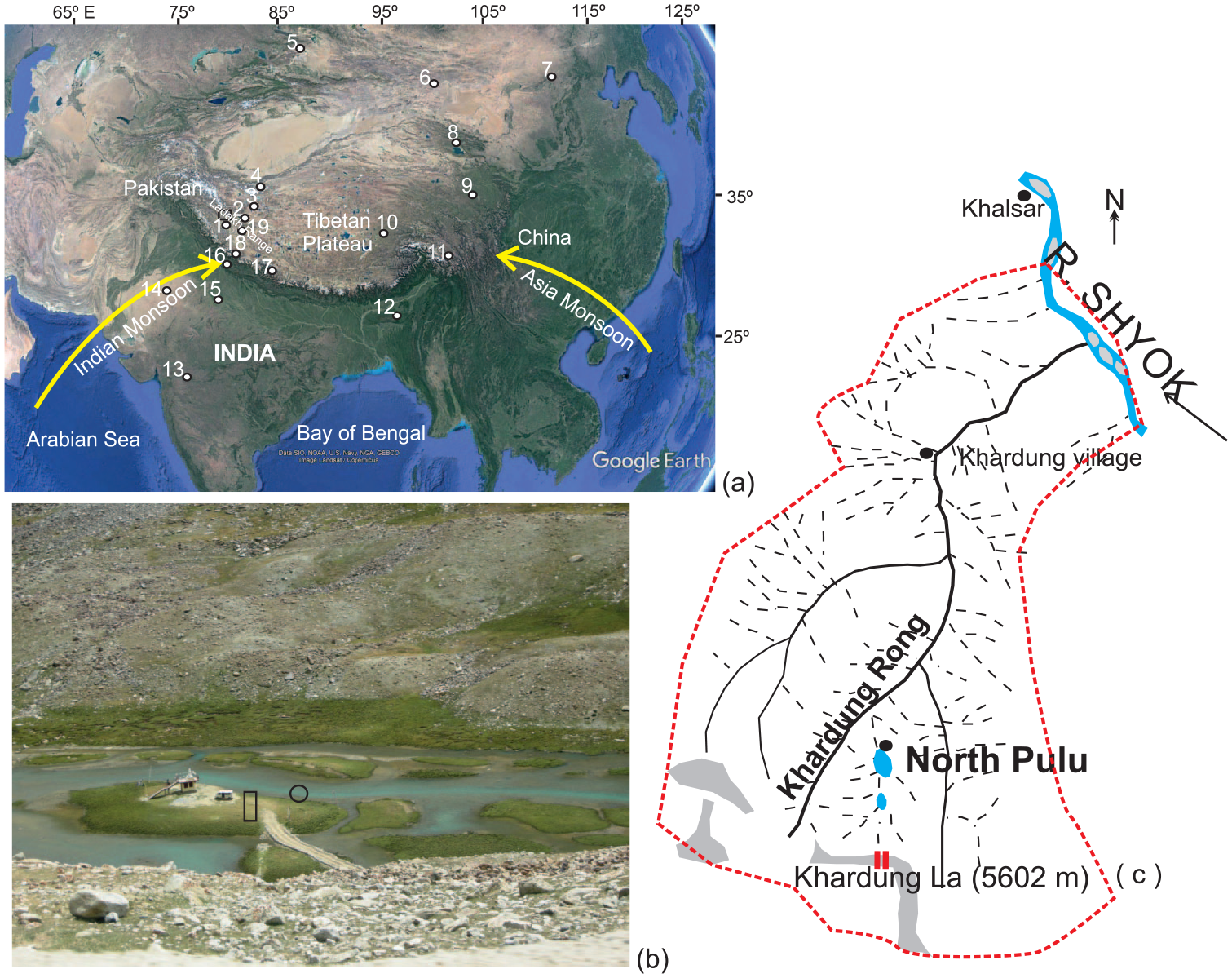
(a) Google image of the TP showing the study area (inside rectangle) and the major precipitation wind direction. Numbers denote other published Holocene records correlated with present study and cited in text (1: Tsokar; 2: Bangong Co; 3: Sumix-Lugmu Co; 4: Guliya ice cap; 5: Lake Manas; 6: Bosten Lake; 7: Daihai Lake; 8: Qinghai Lake; 9: Lake Ximencuo; 10: Ahung Co; 11: Laigu Lake; 12: Mawmluh Cave; 13: Lonar Lake; 14: Lunkaransarpalaeo lake; 15: Kotla Daharpalaeo lake; 16: Sahiya Cave; 17: Lake Rara; 18: Gujjar Hut peat bog; 19: Tso Moriri); (b) North Pulu lake and the location of the pit (cylindrical box) and core (circle) for sampling; and (c) Schematic sketch of the basin showing the drainage pattern.
The two streams originating from the water divide are Khardung rong (28 km) to the north which joins the Shyok River and Sangto Tokpo (26 km) towards the south joining the Indus River. Both these streams host glacial lakes mostly frozen except for few summer months at North Pulu (NP) and South Pulu. NP lake was taken up for the present study (Figure 1b and c).
Material and methods
Samples were collected from the NP (34°17.321′N, 77°35.714′E; altitude: 5098 m a.s.l.; area: ~0.54 sq km) by channel and pit sampling (130 cm) from the raised periphery of the lake and a core (80 cm) from the centre (both separated by a distance of 8 m) from the same lake (Figures 1 and 2). Continuous sampling was done with each sample ranging in thickness from 1.5 to 2 cm. Physical, chemical and biotic proxies were measured for these samples.
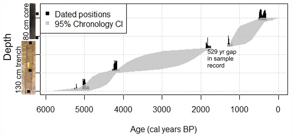
The age–depth graph of the NP section.
Mineral magnetism
Samples were air-dried and packed in standard non-magnetic plastic bottles of 10 cm3. Magnetic susceptibility (χ) at low (0.47 kHz) frequency (χlf) was determined on Bartington Susceptibility Metre (Model MS2) with a dual sensor. Anhysteretic remanent magnetization (ARM) was induced in the samples using a Molspin AF demagnetizer (with an ARM attachment) in a constant biasing field of 0.1 mT superimposed on a decaying alternating field (a.f.) with a peak field of 100 mT at a decay rate of 0.001 mT per cycle. The susceptibility of the ARM (χARM) was calculated by dividing the mass-specific ARM by the size of the biasing field (0.1 mT = 79.6 A m−1; Walden, 1999). Isothermal remanent magnetization (IRM) was induced in selected samples at different field strengths (50, 100, 300, 500, 700 and 800 mT) and backfields of up to 300 mT using an impulse magnetizer (ASC Scientific, USA). Remanence was measured using the JR6 (AGICO). Frequency-dependent susceptibility (χfd%), the S-ratio, SIRM/χlf, χARM/SIRM, B(O)CR and χARM/χlf were used in the analysis. The χfd% value gives a broad estimate of the average size of ferromagnetic grains (Dearing, 1999). The S-ratio is the negative of the ratio of the IRM induced at −300 mT to the SIRM induced at 700 mT (–IRM-300 mT/SIRM 700 mT). The SIRM/χlf ratio gives a determination of grain size. For magnetic mineralogy measurements, the IRM acquisition was performed on all samples. The IRM accusations also show the contribution of magnetite which is the primary mineral contributing to the remanence in these sediments.
Textural analysis
Standard techniques were applied for retrieving sedimentological information (Friedman and Sanders, 1978). For grain size analysis laser-diffraction analyzer, the Coulter LS Particle Size Analyzer was employed. It is the most time-efficient and robust way of obtaining sand, silt and clay fractions distribution. Laser diffraction is used to detect particle sizes in the range of ~0.1 to 2000 µm equivalent spherical diameter using light scattering theory. In this technique, samples are dried and sieved to exclude particles > 2000 µm (2 mm) diameter.
Loss on Ignition
Loss on Ignition (LOI) is used to estimate the combined weight of organic matter, carbonate minerals and moisture present in the sediment. For LOI measurements, 5 g, 200 mesh sample powder was heated in quartz crucibles, and weight loss was measured at 110°C, 550°C and 950°C to determine the moisture, organic carbon and carbonate carbon present, respectively, in the samples (Bengtsson and Enell, 1986; Dean, 1974).
Palynofacies
Samples of 5 gm were taken and treated with 10% HCl and heated in a sand bath for 10–20 min to remove the carbonates from the sediments. After washing with distilled water for two to three times, the samples were treated with a 40% HF solution to dissolve the silicates. The samples are then washed thoroughly, centrifuged and slides are prepared using polyvinyl alcohol and mounted by using Canada balsam (Batten, 1996; Combaz, 1964; Tyson, 1987) and scanned under Olympus BX-51 microscope.
Diatoms
Sample (wet sediment) was treated with cold H2O2 to oxidize organics and 10% HCl to remove carbonates. Permanent Slides were made using Naphrax (R.I-1.74). The diatoms are identified to species level where possible and counted at 100 magnifications using an Olympus BX-51 microscope equipped with an ×100 phase contrast objective. The abundance of species is expressed as a percentage of total values (Battarbee, 1986). The diatom taxonomy follows Round et al. (1990) and Kociolek et al. (2020).
Chronology
Table 1 shows the details of chronology which were obtained from five accelerator mass spectrometer (AMS) radiocarbon dates, two from NP Core and three from NP pit, from Silesian University of Technology, Gliwice, Poland. Standard sample preparation methods were adapted to make graphite targets that were analysed by mass accelerator along with primary and secondary standard and process blanks (Piotrowska, 2013; Ramsey, 2009; Reimer et al., 2013). The dates were calibrated using Bchron, which runs the Compound Poisson–Gamma chronology model of Haslett and Parnell (2008) using IntCal13. The Bchron function fits a compound Poisson–Gamma distribution to the increments between the dated levels. This involves a stochastic linear interpolation step where the age gaps are gamma distributed, and the position gaps are exponential.
Details of the chronology for NP pit and core section.
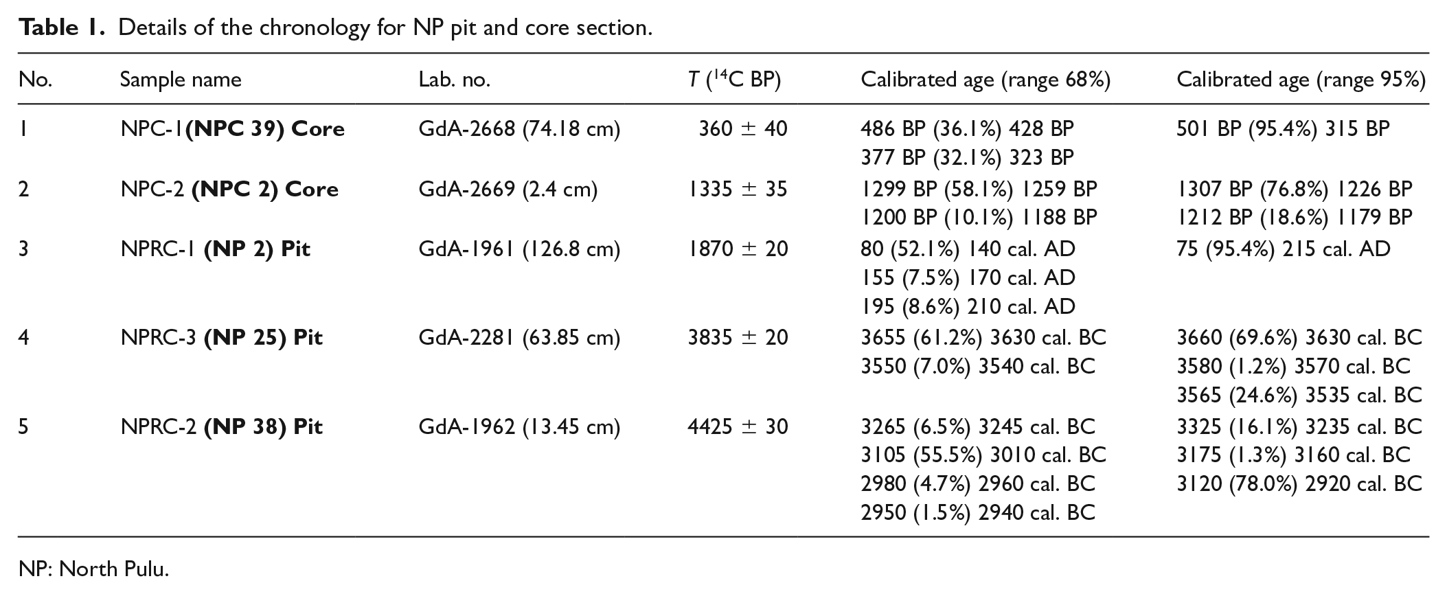
NP: North Pulu.
Results
Based on the frequency and variations of the physical and biotic multi-proxy dataset, TILIA 1.7 software for grouping/cluster analysis using Constrained Incremental Sums of Squares cluster analysis (CONISS) was run, and accordingly three zones were defined (Zones NP-A; NP-B and NP-C) (Figures 5 and 6). A sub-zonation was also possible and NP-A1 to NP-A4; NP-B1 and NP-B2; NP-C1 to NP-C3 sub-zones were assigned. TILIA and TILIA graph software was used for the preparation of a range chart and CONISS was applied for cluster analysis (Grimm, 1987, 1990).
Interpretation of proxies used
The importance of a multi-proxy record is that the different proxies react variably to different environmental factors and consequently exhibit different strengths, weaknesses and responses (Birks and Birks, 2006), hence giving a clearer unbiased picture of palaeoclimatic variations. Nearly 32 proxies, both physical and biotic, were studied.
The formation, transport, deposition and transformation of magnetic content in lake sediments indicate environmental conditions and geomorphic processes in the catchment (Oldfield, 1991; Verosub and Roberts, 1995). The higher values of χlf imply the effectiveness of the erosional processes and the increasing concentration of detrital input from the catchment (Williamson et al., 1998). During the high-intensity erosion, more magnetic particles come as clastic input to the basin, thus increasing the magnetic properties of the sediments. Glacial abrasion is the most influential and powerful mechanical force for the land surface erosion in glacial areas, for example, more the glacial expansion (enhanced glacial erosion), more the generation of magnetic clast, and vice versa. Therefore, glacier advance or retreat can be revealed well by the studies of proglacial lakes (Dahl et al., 2003; Matthews et al., 2000; Nesje et al., 2000). In the present study, the χlf values mostly range from 49–200 (10−8 m3 kg−1), three points exceeding 200 (to 335) (10−8 m3 kg−1) and are considered as short, sharp and sudden (abrupt) events. Similarly, S-ratio, SIRM and B(O)CR are also selectively sensitive for the detrital influx which is the result of either glacial advancement or the glacial melting. χARM and χfd% are the reflection of authigenic contribution not the direct result of catchment erosional processes.
In nature, the particles are generally separated by their sizes, depending on the movements of air and water. The distribution of sizes is related to the availability of different sizes of the parent material, the processes operating, particularly the competency of flow and concentrations of particles in suspension. Hence, the textural analysis was done, which provides basic information in identifying the environment of deposition (Folk and Ward, 1957; Friedman, 1969; Inman, 1949; Krumbein, 1934; Spencer, 1963; Tanner, 1958; Visher, 1969).
In lake and bog systems, the TOC concentration can serve as an indirect indicator of the kind and biomass of local vegetation (Chai, 1990; Zhou et al., 1997, 2004) and thereby potentially reflects changes in the regional precipitation. This method has been widely used for palaeo-environmental investigations (Bendell-Young et al., 2002; Dodson and Ramrath, 2001; Korsman et al., 1999; Phartiyal et al., 2011).
The palynofacies recovered were grouped into oxidized black OM, fully degraded brown OM, partially degraded brown OM, well-preserved OM, amorphous OM, charcoal and palynomorphs (Algae, Fungi, Zooplankton, Spores, Insect and animal elements). On the basis of palynofacies, the characterization of depositional environment, redox conditions, productivity and the stability of the water column (stratified/seasonally stratified/continuous mixed) was done (Tyson, 1995).
Diatoms are a major group of microalgae and the most common types of phytoplankton with a cell wall made up of silica called frustules and are excellent palaeo-environmental indicators. Diatom abundance in the glacial lakes is controlled by water temperature, sediment input and summer ice cover, pH and nutrient flux (Cantonati et al., 2017). The predominant species of diatoms recorded are Encyonema minutum, Stauroneis anceps, Achnanthidium minutissimum, Nitzschia palea, Amphora ovalis, Cymbella lanceolata (Brebissonia lanceolata), Cymbella tumida, Gomphonema truncatum, Pinnularia subcapitata, Eunotia bilunaris, Hantzschia amphioxys, Navicula cincta and Tabellaria flocculosa. Achnanthidium minutissimum is abundant in flowing water and streams, which is a condition of warm climate. Cymbella tumida and Cymbella lanceolata indicate increased lake productivity and resided at the water/sediment interface in shallower water bodies. Hantzschia amphioxys denotes cold climatic conditions. Eunotia bilunaris appearance shows the shallow level of the lake. Stauronesis anceps indicates warmer climatic conditions with moderate to high water levels in the lake. The presence of Stauronesis anceps, Nitzschia palea, Navicula cincta and Achnanthidium minutissimum expresses stress (anthropogenic) conditions.
Figure 3a–c shows all the 32 proxies plotted against the section and core in chronological order. Eleven out of these parameters studied and plotted as seen in the Cluster Tree dendrogram (Figure 4) as the best representative of this dataset. The proxies chosen are χlf, χARM, SIRM, clay%, oxidized black OM, fully degraded brown OM, zooplankton, charcoal, Cymbella tumida and Cymbella lanceolata (Brebissonia lanceolata), Pinnularia subcapitata and Stauroneis anceps (Figures 4 and 5).
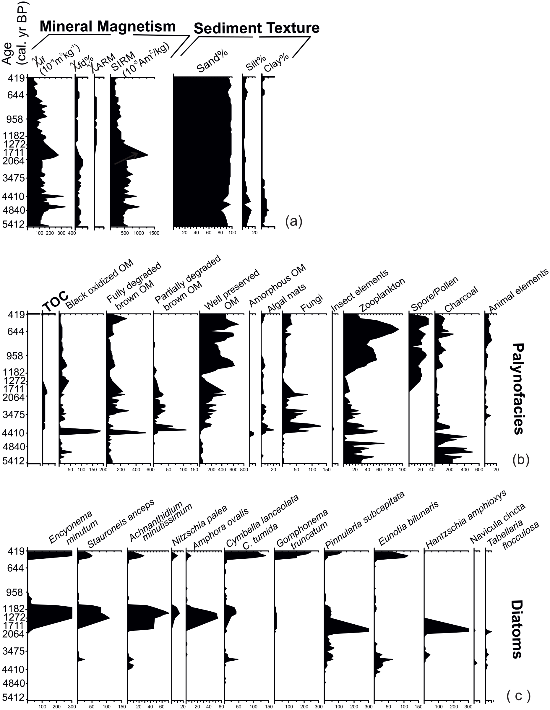
The graphs of various parameters of different proxies: (a) Mineral magnetism: χlf, χARM, SIRM; Textural analysis: sand%, silt%, clay%; (b) Total Organic Content (TOC%); Palynofacies: Oxidized black OM, Fully degraded brown OM, Partially degraded brown OM, Well-preserved OM, Amorphous OM, Algal Mats, Fungi, Insects elements, Zooplankton; (c) Diatoms: Encyonema minutum, Stauroneis anceps, Achnanthidium minutissimum, Nitzschia palea, Amphora ovalis, Cymbella lanceolata, (Brebissonia lanceolata), Cymbella tumida, Gomphonema truncatum, Pinnularia subcapitata, Eunotia bilunaris, Hantzschia amphioxys, Navicula cincta and Tabellaria flocculosa for pit and core both are plotted against the chronology.
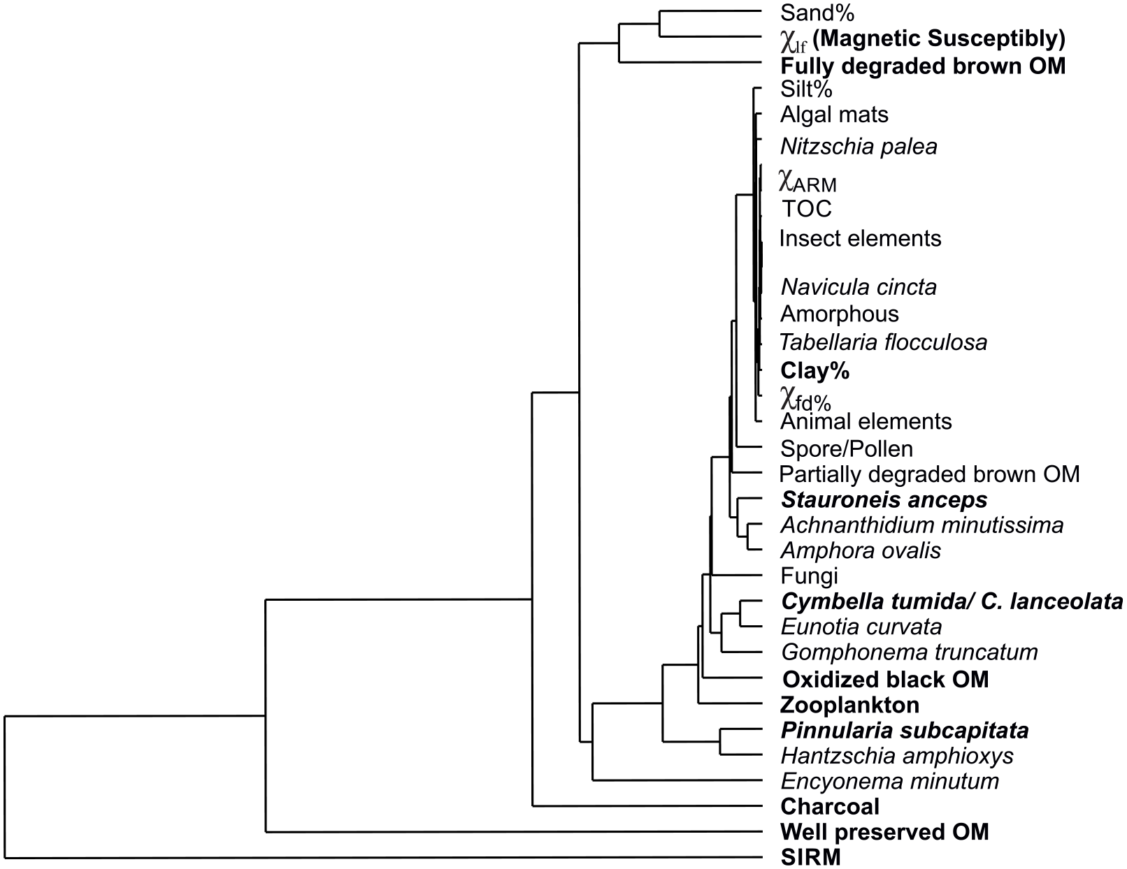
Tree diagram is showing the affinity of the studied parameters. The cluster analysis was done by CONISS. SIRM is making the most discrete cluster in the analysis. Well-preserved OM and charcoal make another independent cluster. Sand% and χlf are making a very close cluster compared with other parameters. Clay%, TOC, χARM, χfd%, partially degraded brown OM and amorphous OM form a single cluster.
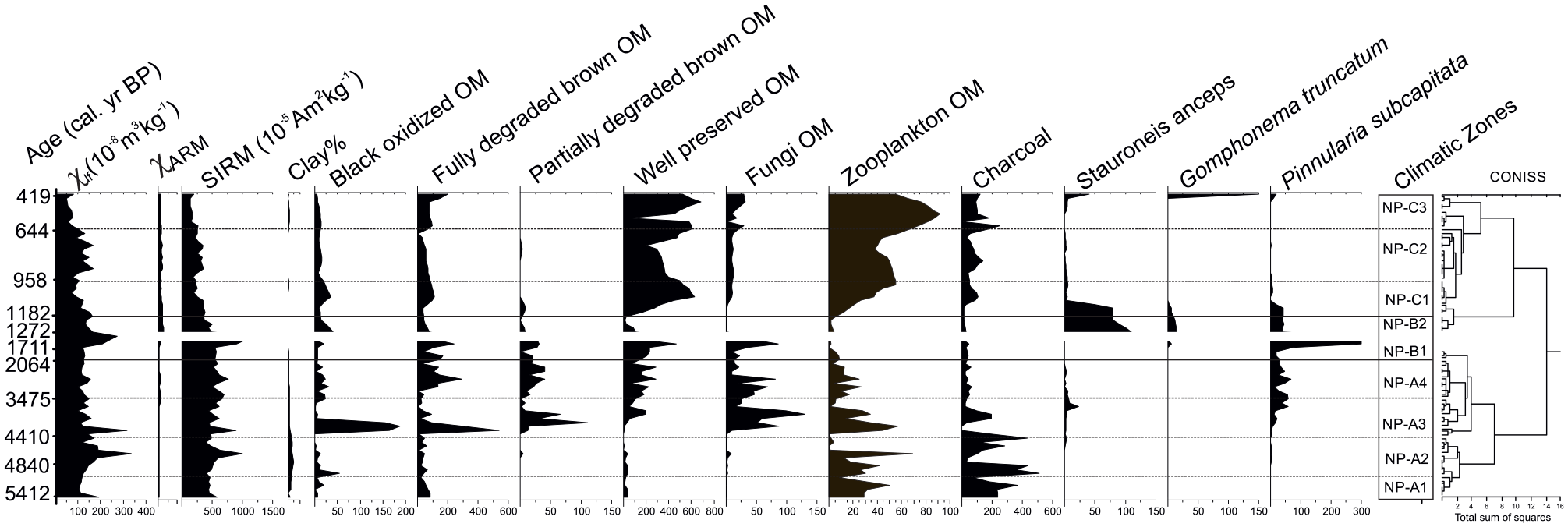
The climatic zones and sub-zones on the basis of represented parameters.
Zone NP-A1 (5412–4840 cal. yr BP)
This zone constituting of a 572-year period, records fluctuating χlf, χARM, SIRM, S-ratios (0.7–1.0) values, high sand%, increase in silt and clay% and very low TOC (0.4–0.7%) values (Figure 3a and b). An increasing trend of oxidized black OM, absence of partially degraded brown OM, small quantity of well-preserved OM and ample of zooplanktons is also recorded (Figure 3b). The most characteristic feature of this zone is the presence of a high number of charcoal specks that increase towards the upper part of the zone. The zone is completely devoid of diatoms.
This period was a mild cold period, as indicated by χlf, χARM, SIRM trends. The freeze–thaw action and enhanced weathering during this cold phase generated a higher amount of sediment. The low value of TOC percent, small amount of well-preserved organic matter, increasing trend of oxidized black OM and high number of charcoal all indicate unfavourable climatic condition for organic productivity and anoxic lake condition.
Zone NP-A2 (4840–4410 cal. yr BP)
This 430-year period shows relatively high χlf values (with one high peak (335 × 10−8 m3 kg−1) at 4678 cal. yr BP), increasing clay and sand percentage and sharp fluctuations in silt component (Figure 3a). TOC shows a very slight increase, while the oxidized black OM appear but with a decreasing trend and almost disappears towards the top. The well-preserved OM shows sharp decreasing trend and a remarkable abatement of zooplankton is recorded (Figure 3b). The charcoal number decreases at the commencement of this period but dramatically shows an increasing trend in the upper part of the zone. Eunotia bilunaris appears in a very minute number (Figure 3c).
This zone is colder than the preceding zone and records minor fluctuations. The influx of more coarser grain size is seen as higher proportion of sand percentages which is responsible for higher magnetic susceptibility (χlf) values too. However, clay also shows a relative increment in percentage. The abrupt phase at 4678 cal. yr BP denotes a sharp and sudden climate event. The decline in well-preserved OM indicates oxidizing conditions and the decreasing trend of oxidized black OM and charcoal support it. This oxidizing condition could be due to the lowering of lake levels. The charcoal population has a fluctuating status and may be due to increased aeolian activity. The appearance of Eunotia bilunaris also indicates the shallow level of the lake, as these are epipelic species that live in association with fine-grained substrata in shallower lakes. All these variations collectively indicate a glacial advancement due to a cooler climate.
Zone NP-A3 (4410–3475 cal. yr BP)
This 935-year period shows sharp fluctuations in diatom proxy response (Figure 3c) along with a slight decrease in χlf values (but one sharp peak 315 × 10−8 m3 kg−1) recorded at 4400 cal. yr BP. The magnetic parameters in this zone show elucidatory variations in values. χlf shows increased values at 4200, 3800 and 3500 cal. yr BP. All other magnetic parameters follow the same pattern with SIRM showing a slight increase. There is a sharp increase in sand%, while silt% and clay% decrease (Figure 3a). High TOC values, increasing trend of well-preserved OM, decrease in charcoal and an abrupt advent of partially degraded OM and fungal elements along with exiguous algal mats are seen (Figure 3b). Diatom genera namely, Achnanthidium minutissimum, Cymbella spp., Pinnularia subcapitata, Eunotia bilunaris, Hantzschia amphioxys and Stauroneis anceps are seen, although lower in number/counts.
This was a period of the overall cooler conditions marking a transition phase to the overlying moderate warm climatic conditions and high lake levels. A relative decrease in values of χlf as compared with the previous zone can be understood as a lower concentration of magnetic mineral reaching in the lake basin. The abrupt high peak demonstrates the sudden, short-lived colder climatic phase. The increase in SIRM value points to enhanced clastic input by glacial activity. χfd% does not show a considerable decrease as compared with SIRM enhancement. This mutual contradiction can be explained as the authigenic influence of restricted bottom water conditions that may have arisen due to the less oxygenated cooler environment. High TOC%, increasing trend of well-preserved OM and decreasing charcoal represent reducing conditions, that is, high lake-level conditions prevailed. A significant detrital influx is seen but a considerable reducing condition also prevailed. This can be due to two opposite processes prevailing in the catchment, that is, glacial advance and glacial melting. The most distinctive feature of this zone is the cyclicity which holds a clue to tangle this conundrum of the glacial condition of an advance and melting. The cyclicity recorded at 4400, 4200, 3800, 3500 cal. yr BP (higher χlf values) and at 4300, 3900, 3700 cal. yr BP (lower χlf values) can be seen sharply in magnetic parameters (Figures 4 and 5). This is present but rather subtle in other proxies too. The cyclicity ranging from 100 to 200 years in the colder and warmer phases generates fluctuations in all proxies; however, varying intensity among proxies could be due to the response of different proxies. This difference can be associated with the climate and non-climate variability also. The first appearance of Achnanthidium minutissimum, Cymbella spp., Pinnularia subcapitata, Eunotia bilunaris, Hantzschia amphioxys and Stauroneis anceps depicts additional climatic inferences. Achnanthidium spp. is abundant in flowing waters/streams, which is a condition of warm climate. Stauroneis anceps indicates warmer climatic conditions with moderate to high water levels in the lake. Hence, the fluctuations do show fluctuating coal and warm conditions in this zone.
Zone NP-A4 (3475–2064 cal. yr BP)
It is a 1411-year period showing a decreasing trend in χlf, χARM, SIRM values. Only one peak of higher value (155 × 10−8 m3 kg−1) at 3004 cal. yr BP and one trough of lower value (98 × 10−8 m3 kg−1) at 3239 cal. yr BP is recorded. An increase in sand% and silt% and very less clay content is seen. TOC% and fully degraded brown OM show an increasing trend whereas partially degraded material, well-preserved OM and zooplankton show a decreasing trend. There is a great reduction in the charcoal percentage too. Achnanthidium minutissimum, Cymbella spp. and Hantzschia amphioxys sharply wear off completely towards to top of the zone, whereas Pinnularia subcapitata remains in the same and Eunotia bilunaris shows a remarkable waning too.
The overall, climatic condition is indicative of a warmer trend but decreasing towards the top. The peak and trough show the same cyclicity of that in the previous zone. The centennial-scale cyclicity occurs with a time-lapse of ~200 years. The circulation and redox potential of the water body, that is, lake, have useful inferences to understand fluctuations in the climate. The consistent higher TOC% is the indication of a stagnant water body with moderate to high levels. This also coincides with higher well-preserved OM, an elucidative sign of anoxic condition in the lake, which may be due to higher lake level. The abrupt disappearance of Achnanthidium minutissimum, towards the top, a genus of running water, supports the stagnant condition of the lake. The high level of the lake is also evident from the continuous decreasing trend and finally waning of and Eunotia bilunaris in this zone, which is generally associated with shallower water bodies. The complete disappearance of Cymbella spp. in this zone also hints of the warm climatic condition and increased lake levels.
Zone NP-B (B1: 2064–1711; 439-year gap in sediment record; B2: 1272–1182 cal. yr BP)
This zone comprises of an 882-year period, divided into NP-B1 and B2. We miss the sediment record from 1711 to 1272 years, a total of 439 years (due to the gap in sample collection from pit section and the core raised). NP-B1 shows very sharp increasing trends in χlf, SIRM values, sand, silt and clay% which decreases in NP-B2. In zone NP-B1, a sharp higher value of χlf is recorded with the value of 272 × 10−8 m3 kg−1 at 1711 cal. yr BP, which is the boundary of the zone. Palynofacies follow a decreasing trend in which charcoal and fungal elements record the lowest percentage. Encyonema minutum, Stauroneis anceps, Achnanthidium minutissimum and Amphora ovalis dramatically appear in a large number (NP-B2). Pinnularia subcapitata and Hantzschia amphioxys fluctuate from higher to lower numbers.
Very sharp, decreasing trends in χlf, SIRM, sand, silt indicates warmer conditions (NP-B2). The sudden large appearance in the Amphora ovalis is seen. Amphora ovalis is mostly free-living benthos of alkaline water and mostly prefers higher trophic levels with medium to high electrolyte content and is present in oligotrophic to mesotrophic water (Levkov, 2009). Its presence indicates increased nutrient input into the lake with the warmer climatic condition and moderate water level in the lake. The overall condition, during 2064–1711 cal. yr BP represents the colder phase, and conditions improve during 1272–1182 cal. yr BP.
Zone NP-C1 (1182–958 cal. yr BP)
This 224-year period is showing decreasing trend in χlf and SIRM, consistent sand, silt and clay percentage compared with the previous period. An increasing trend of oxidized black OM, fully degraded brown OM, charcoal and fungal elements are recorded. Well-preserved palynofacies element and zooplankton shows a remarkable increase in this period. Encyonema minutum, Stauroneis anceps, Achnanthidium minutissimum and Amphora ovalis drastically decrease in number. During the 224 years between 1182 and 958 cal. yr BP, a decreasing trend of χlf and SIRM indicates warmer climatic conditions at the basal levels of this zone. SIRM decreases relatively and shows lesser decline representing the ferromagnetic and anti-ferromagnetic mineral concentration. The mineral concentration could either be detrital or both. The χlf and SIRM show higher values at the base of this zone and lower values at upper horizons grading to a colder climatic condition. The remarkable increase in well-preserved OM is a token of reducing condition hence high lake levels due to glacial melting. In contrast, the oxidized black OM and charcoal have also increased in this zone, which indicates oxidizing conditions. The sudden decrease in the Amphora ovalis and Achnanthidium minutissimum towards the top indicates the low water level in the lake with reduced nutrient runoff and cold climatic conditions at the end of this period.
Zone NP-C2 (958–644 cal. yr BP)
A 314-year period with increasing χlf and SIRM, granulometric percentages remaining the same as of previous zones is recorded. At 913, 845, 778, 711 cal. yr BP, χlf shows a sudden rise in values up to 167, 148, 169, 137 × 10−8 m3 kg−1, respectively. Well-preserved matter and zooplanktons are showing an increasing trend while Oxidized Black and fully degraded brown OM shows a decrease. Diatoms completely disappeared in this zone.
The return of cold climate is seen with an overall increasing trend of proxy data, with fluctuations in χlf, SIRM indicating enhanced weathering. In this cold climate condition, the increasing trend in well-preserved OM indicates the anoxic condition of the lake which may be due to enhancement of influx of organic matter from the catchment. The complete disappearance of diatoms from this zone also indicates the return of severe cold climate; moreover the increasing influx of organic matter from the catchment may have led to alkaline condition.
Zone NP-C3 (644–419 cal. yr BP)
This 225-year period shows a decreasing trend in χlf and SIRM with the lowest values. Sand, silt and clay percentages show consistency with previous zones. Well-preserved OM and zooplankton follow the same increasing trend. Encyonema minutum, Cymbella spp. and Gomphonema truncatum reach exceptional values at the completion of this zone. Stauroneis anceps, Achnanthidium minutissimum, Nitzchia palea, Pinnularia subcapitata and Eunotia curvata are also present considerably.
During the period between 644 and 419 cal. yr BP, warm climatic condition is recorded. Decreasing trend of χlf and SIRM and increasing trend of well-preserved OM indicate the warm climate with reducing the condition of the lake. Increase in the diatoms like Gomphonema truncatum and Nitzschia palea also indicates eutrophic (increased nutrient runoff) and alkaline conditions of the water. Moreover, diatoms like Achnanthidium minutissimum and Stauroneis anceps further indicate warm climatic conditions with higher water levels.
Discussion
The present study presents a high-resolution multi-proxy data from an eventful last five millennia period, from a glacial lake in Ladakh, western part of the TP, where there is still a gap in the climate dataset considering the well-studied lakes of the TP (northern and eastern part) and in the south the Lesser Himalayan and the Higher Himalayan lakes (Figure 1 – locations of well-studied lakes). Glacial lakes are directly influenced by sub-aerial glacial meltwater (Carrivick and Tweed, 2013; Song et al., 2017), and the characteristics and conduct of proglacial lakes are intrinsically linked to climate. As they are also concomitant to wider geological systems through glacier dynamics, glacial meltwater and sediment fluxes (Ashraf et al., 2017; Carrivick and Tweed, 2013; Huang et al., 2016; Juyal et al., 2009; Larsen et al., 2011; Wang et al., 2014), they were taken up for this study. Contemporary deglaciation nowadays is producing an increased number and size of proglacial lakes around the world, including Himalaya (Gardelle et al., 2011) and Tibet (Chen et al., 2007; Wang et al., 2011c). These lakes are significant important geochronological archives providing short-term inter-seasonal and inter-annual patterns along with the long-term trends of glacier-derived meltwater fluctuation as well.
NP lake is a high-altitude proglacial lake at 5098 m a.s.l. formed by the deglaciation in the Ladakh range. This lake is directly influenced by sub-aerial glacial meltwater and can be intrinsically linked to climate. Based on the frequency and variations of the physical and biotic multi-proxy dataset, three zones and their subsequent sub-zones were defined from 5412 to last 419 cal. yr BP.
Our results (Figure 6) suggest cold conditions at 5400–4800 cal. yr BP and severely cold and dry conditions between 4800 and 4400 cal. yr BP in Ladakh Himalaya. During this cold period, low lake levels were experienced (Figures 5 and 6). Biome reconstruction also advocates for a reduction in moisture availability after ~6200 cal. yr BP from the Tso Moriri (Lei et al., 2014, b). Similarly, Wünnemann et al. (2010) observed a declined detrital input due to reduced meltwater flux and a gradual shrinking of the Tso Kar after 7000 cal. yr BP with lowest stand at ~4200 cal. yr BP. These conditions also coincide with the south-eastern TP proglacial Laigu Lake dataset (Huang et al., 2016). The magnetic susceptibility from NP and Laigu responds similarly and expresses a glacial expansion and increase in glacial erosion at ~4500–3900 cal. yr BP. Other studies on Holocene climatic record also demonstrate that TP experienced a prominent climate change around 4600 cal. yr BP. Lake sediment archives confess of a decreasing monsoonal dynamics and a trend towards dryer and colder conditions since 4700 cal. yr BP (Morrill et al., 2006) and between 4400 and 3900 cal. yr BP and in Qinghai lake (Chen et al., 1990; Ji et al., 2005; Lister et al., 1991; Shen et al., 2005a, 2005b). The sudden start of glacier activity, that is, neoglaciation at 4300 cal. yr BP and continuous escalation till 3800 cal. yr BP reported from Laigu Lake, strengthens our results of colder climate in Ladakh range; hence, this was a regional scale cooling phase. During this period, around 4300 cal. yr BP marks the end of Holocene Climate Optimum (Wu and Liu, 2004) which also records maximum aridity in Holocene (Fontes et al., 1993). These conditions are the consequence of a decrease in summer insolation that reduced both temperatures and precipitation (Bosmans et al., 2012). The abrupt high peak at 4600 cal. yr BP in NP-A-2 zone reflects a sharp very severe cold event in the 4700–4400 cal. yr BP cold phase. A cyclicity in the colder fluctuations is seen which falls at 5700, 4600, 4400, 4200, 3800, 3500, 3000, 1800–1700, 1200, 910, 840 and 770–710 cal. yr BP in NP record. The 4400, 4200 and 3800 cal. yr BP events are coincident with the Bosten lake in northwestern China (Wünnemann et al., 2006). Multi-centennial trend to drier and possibly cooler conditions in the Indus Valley region started around ~4100 years ago as inferred from the Sahiya δ18O record (Kathayat et al., 2017). From 4400–3400 cal. yr BP, a transition phase showing slightly warmer condition than the previous zone and with cold events at 4200, 3800, 3600 and 3000 cal. yr BP as stated above. Biotic proxies indicate less oxygenated conditions and high lake levels. The ‘weak monsoon’ term is given to 4.2 ka event as is recorded from Tso Kar lake (Wünnemann et al., 2010), Daihai lake, Inner Mongolia China (Xiao et al., 2018); Mawmluh Cave speleothem, northeast India (Berkelhammer et al., 2012); Lonar Lake, Central India (Anoop et al., 2013; Menzel et al., 2014; Prasad et al., 2014); Sahiya Cave, North India (Kathayat et al., 2017); Lake Rara, Nepal Himalaya (Nakamura et al., 2016; Yasuda and Tabata, 1988) and Central Higher Himalaya (Phadtare, 2000). This shift of climate to dryer and colder conditions coincided with the collapse of Neolithic culture in central China (Shao et al., 2006; Wu and Liu, 2004), Indus Valley civilization (Berkelhammer et al., 2012; Dixit et al., 2014; Enzel et al., 1999; MacDonald, 2011; Singh et al., 1974; Staubwasser et al., 2003; Swain et al., 1983). Similarly, regression of steppe and alpine meadow cover an indication of colder climate in Bangong Co basin, from ~ 5700 to ~ 3800 yr BP, (Gasse et al., 1996); cold event between 4200 and 2800 cal. yr BP at Lake Ximencuo (Mischke et al., 2010) (for location refer to Figure 1) indicates a regional scale cold and dry period covering a large part of the Himalaya, Ladakh, Tibet and China. Based on the various proxies, the interval 3800–3200 yr BP is interpreted as an arid episode with peak aridity at ~3800 yr BP (Gasse and Campo, 1994; Gasse et al., 1996; Mischke et al., 2002; Rhodes et al., 1996). The diffuse reflectance spectroscopy data from Qinghai Lake (Ji et al., 2005), alkenone-based reconstruction (Liu et al., 2006) and fluvial sediments (Liu et al., 2011) show a low stand between ~3700 and ~2300 cal. yr BP. The low lake level began to rise after ~2400 cal. yr BP, reaching the highest point at the 1770 cal. yr BP (Liu et al., 2016) also corresponding to the ‘Roman Warm Period’ (150 BC–AD 270). This is also been reported in studies from Qinghai Lake (Ji et al., 2005; Liu et al., 2006, 2008) and western China (Yang et al., 2002) too. A large amount of Gramineae and Cyperaceae indicating maximum aridity around 3500 yr BP (Campo et al., 1996) with a minor amplitude wet episode at ~3300 to ~2100 yr BP (Gasse et al., 1996) is recorded. The period from 2064 to 1182 cal. yr BP (NP-B) hints at warmer and oxidizing climatic conditions (Figure 6) synchronous with a warm and wet climate at Qinghai Lake during 2100–1500 cal. yr BP, after which the lake levels declined gradually from 1770 to 320 yr BP (Ji et al., 2005). The 1182–958 cal. yr BP period is a warm phase followed by the return of cold climate during 958–644 cal. yr BP, the expression of the ‘Little Ice Age’ over Trans-Himalaya. This cold, dry stage is also recorded in the redness curve of Qinghai Lake (Dark Ages Cold Dry Period (AD 900–1400)) (Liu et al., 2006); in the pollen record of Bangong Tso (Gasse et al., 1996) (Figure 6). Warm conditions prevailed again between 644 and 419 cal. yr BP with reducing lake conditions. This continuous increase in aridity (reduction of precipitation) and warming (increase in temperatures) is responsible for the substantial loss of ice/snow cover over the entire Ladakh range in the recent times, probably hinting of the warm period continuing from 419 cal. yr BP till today.
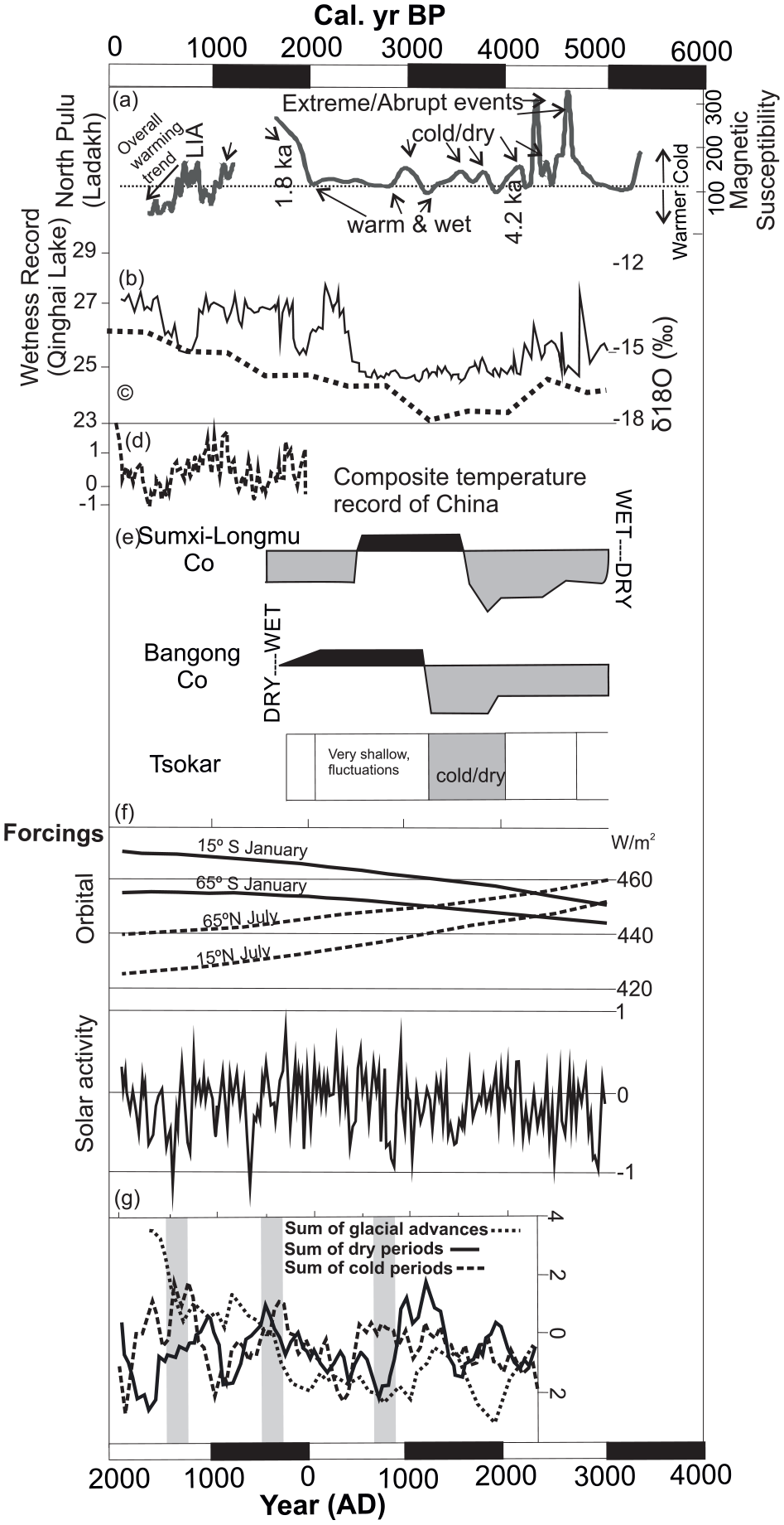
Comparative sketch of the NP record with the other indices and records: (a) Magnetic susceptibility of NP; (b) wetness record of Lake Qinghai (Ji et al., 2005); (c) average of δ18O‰ from Guliya core (Thompson et al., 1997); (d) the composite temperature record in China (Yang et al., 2002); (e) reconstruction of wet–dry record from Sumxi-Longmu Co (Fontes et al., 1993), Bangong Co (Gasse et al., 1996), Tsokar (Wünnemann et al., 2010); (f) orbital forcing, solar activity in northern hemisphere; and (g) sum of the glacial advances, cold periods and dry periods in northern hemisphere (Wanner et al., 2008).
Conclusion
Present work is the high-resolution record from Ladakh, Trans-Himalaya, using glacial lake sediment as an archive and using multi-proxy high-resolution data. The intermittent warm and cold periods are recorded in which the cold events are seen as short-lived, sudden events at 5700, 4600, 4400, 4200, 3800, 3500, 3000, 1800–1700, 1200, 910, 840 and 770–710 cal. yr BP in this NP record. From 5600 cal. yr BP, the conditions in the Ladakh range ameliorated continuously, but the short-lived, sudden (abrupt) cold events did appear. This record is synchronous with the cold and dry period pertaining after the mid-Holocene warming (4800–4200 cal. yr BP) to a great extent. The cold and dry period followed by a warmer phase (4200–2000 cal. yr BP) was responsible for the expansion of human activity (civilizations) in the TP region, including the Indian subcontinent. This ~2000–800 cal. yr BP event was restricted spatially to this region only. At 900–700 cal. yr BP, the LIA is observed, with the anoxic condition of the lake. From 600–300 cal. yr BP, warm climatic condition prevailed, which did not have a widespread impact. This warm climatic condition may have been the reason for the total melting of the ice cover of the entire Ladakh range, where no glaciers are seen today.
Footnotes
Acknowledgements
Special thanks to Dr Anupam Sharma for assistance in the field. We are thankful to DC, Leh and Wild Life Department, Jammu (J&K), for the permission to carry out studies in the protected sanctuary area.
Funding
The author(s) disclosed receipt of the following financial support for the research, authorship and/or publication of this article: This work was performed under the auspices of Birbal Sahni Institute of Palaeosciences, Lucknow, India (BSIP/RDCC/18/17-18) and funded by SERB, Department of Science and Technology, New Delhi (Project No. SR/DGH-69/13).